Total solar eclipse of 06/04/1388
| Day of week: | Wednesday |
| Maximum duration of eclipse: | 03m20s |
| Maximum width of eclipse path: | 302 km |
| Saros cycle: | 127 |
| Coverage: | 100% |
| Magnitude: | 1.0552 |
| Gamma: | 0.7944 |
Wo kann man die Sonnenfinsternis vom 06/04/1388 sehen?
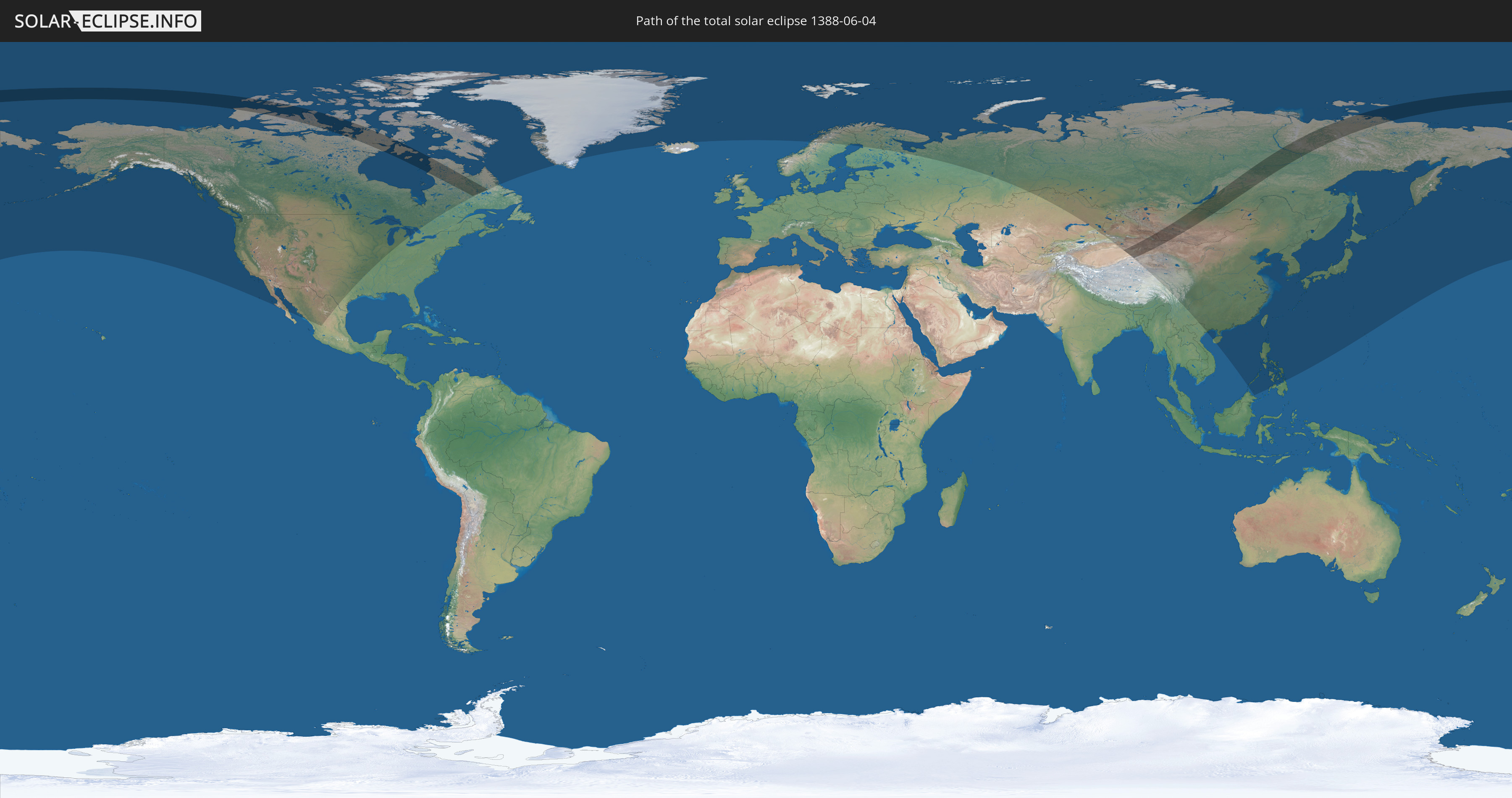
Die Sonnenfinsternis am 06/04/1388 kann man in 22 Ländern als partielle Sonnenfinsternis beobachten.
Der Finsternispfad verläuft durch 4 Länder. Nur in diesen Ländern ist sie als total Sonnenfinsternis zu sehen.
In den folgenden Ländern ist die Sonnenfinsternis total zu sehen
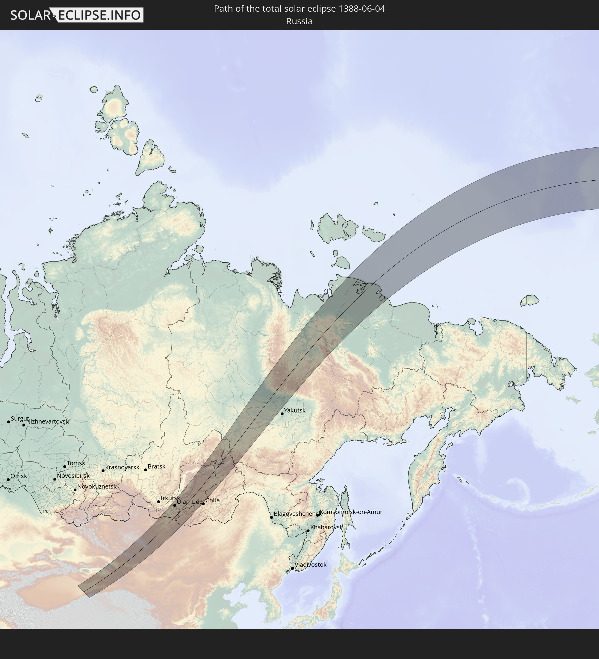 Russia
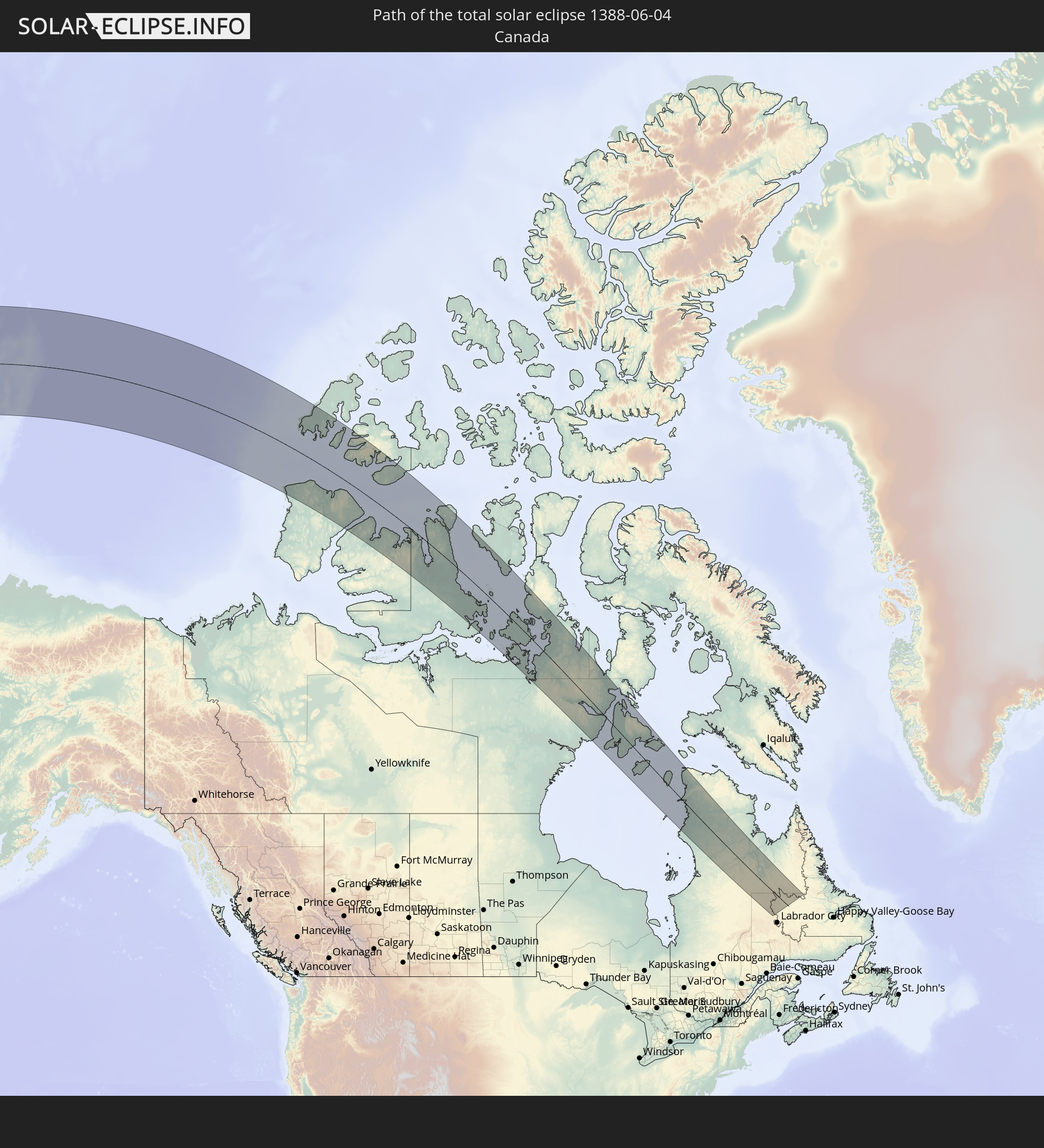 Canada
 China
China
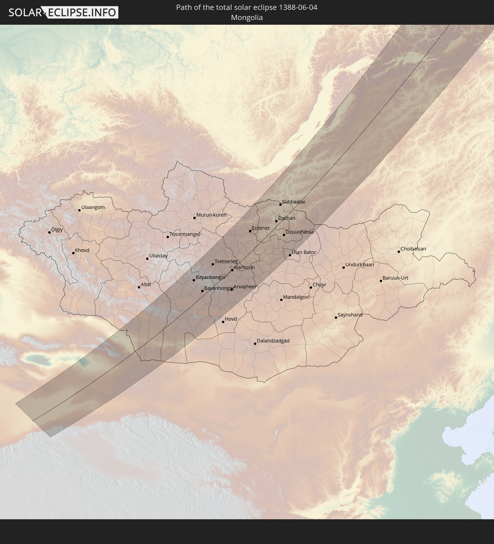 Mongolia
In den folgenden Ländern ist die Sonnenfinsternis partiell zu sehen


How will be the weather during the total solar eclipse on 06/04/1388?
Where is the best place to see the total solar eclipse of 06/04/1388?
The following maps show the average cloud coverage for the day of the total solar eclipse.
With the help of these maps, it is possible to find the place along the eclipse path, which has the best
chance of a cloudless sky.
Nevertheless, you should consider local circumstances and inform about the weather of your chosen
observation site.
The data is provided by NASAs satellites
AQUA and TERRA.
The cloud maps are averaged over a period of 19 years (2000 - 2019).


Detailed country maps
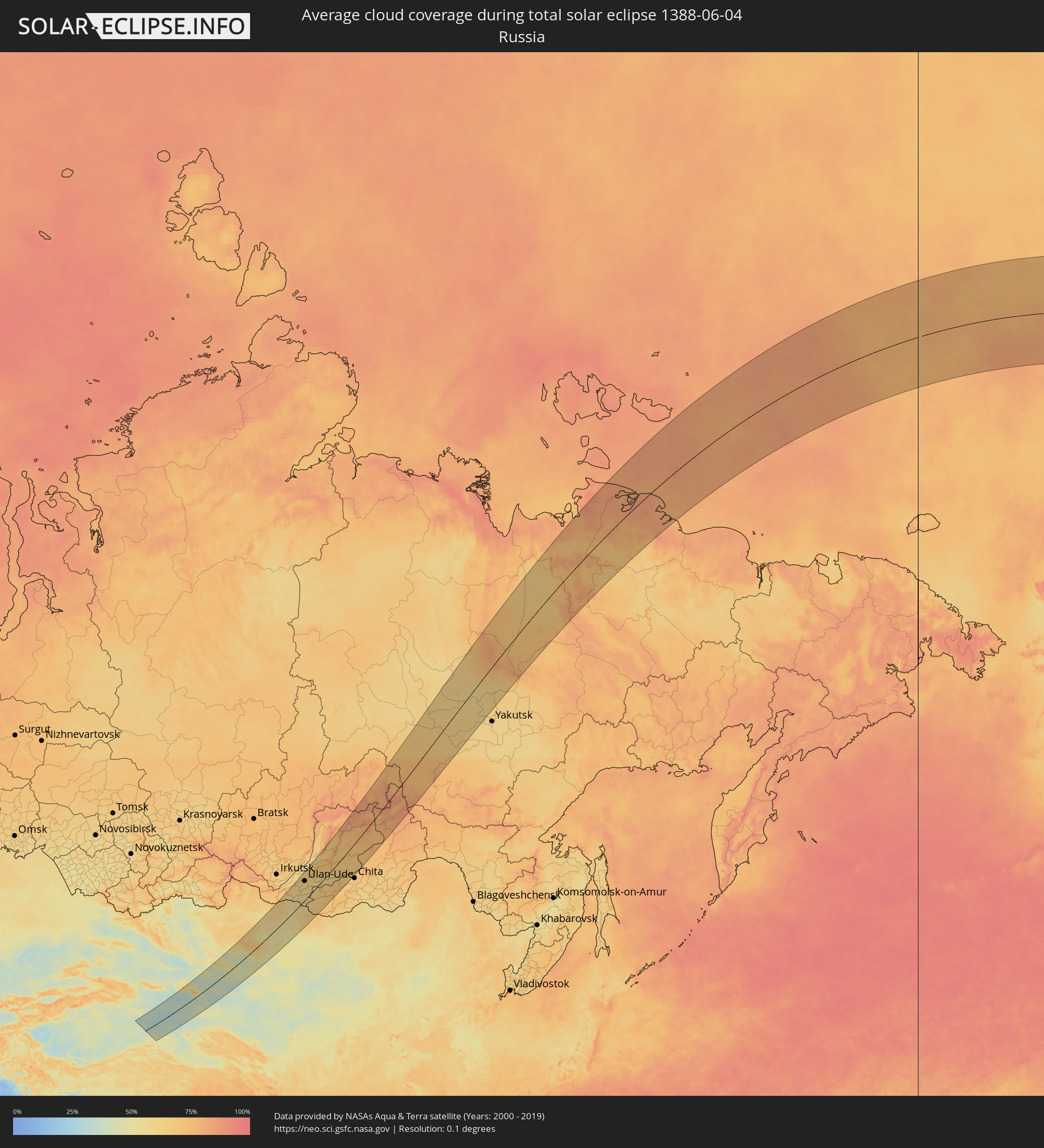 Russia
 Canada
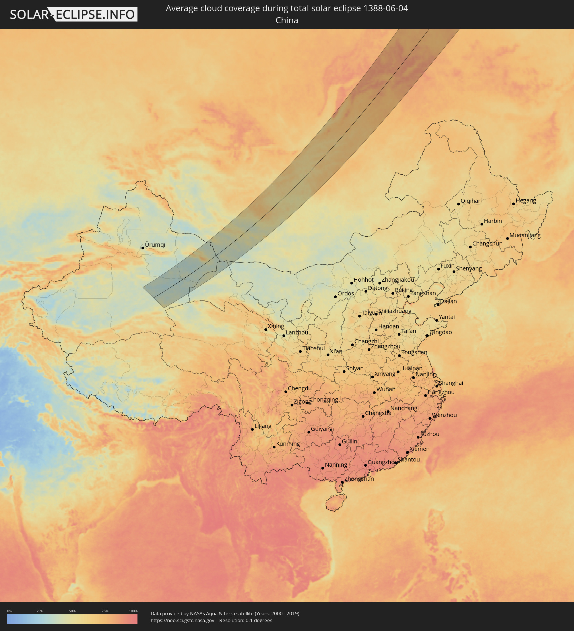 China
China
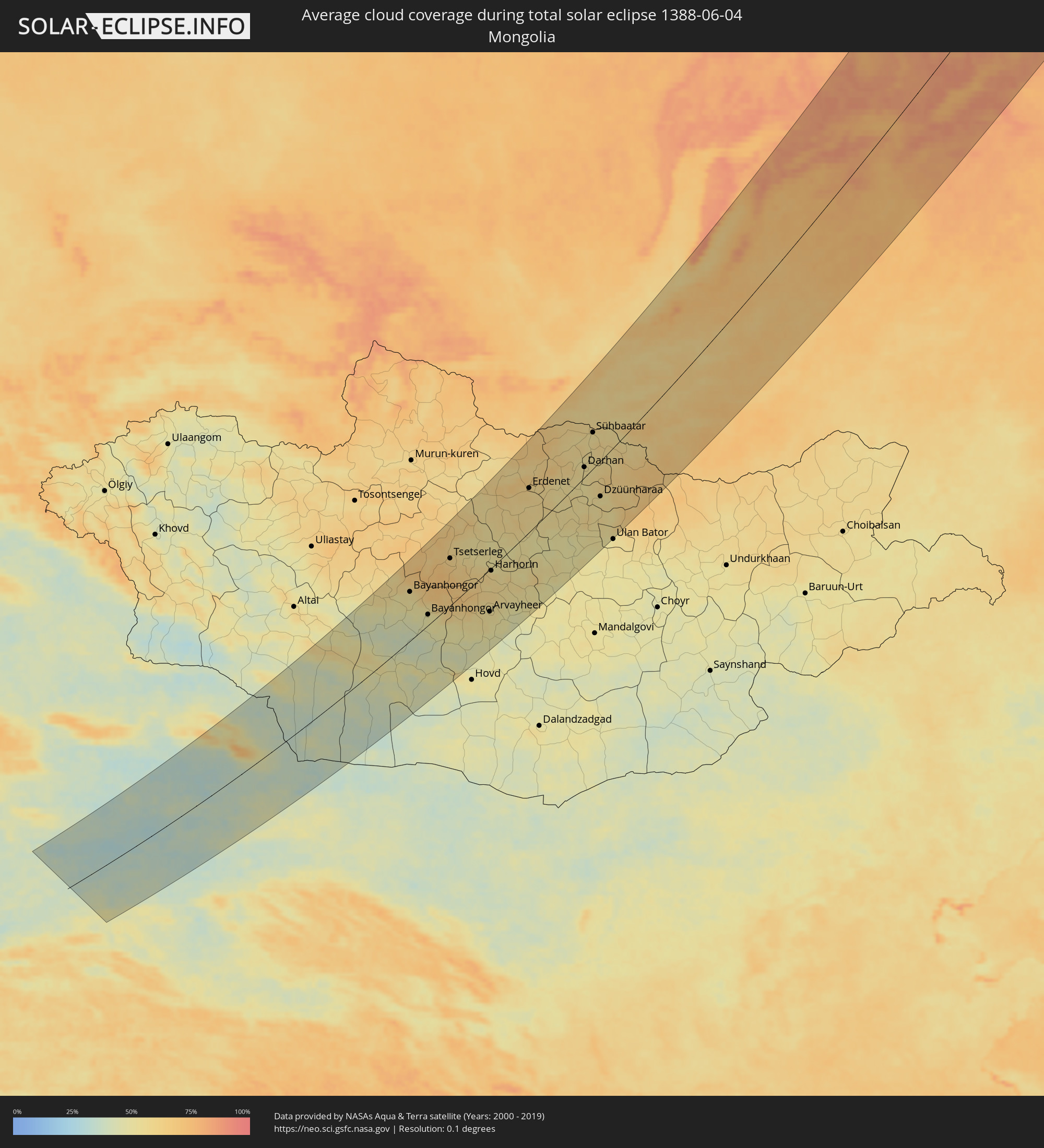 Mongolia
Cities inside the path of the eclipse
The following table shows all locations with a population of more than 5,000 inside the eclipse path. Cities which have more than 100,000 inhabitants are marked bold. A click at the locations opens a detailed map.
| City | Type | Eclipse duration | Local time of max. eclipse | Distance to central line | Ø Cloud coverage |
 Hami, Xinjiang Uyghur Autonomous Region
|
total | - | 06:42:18 UTC+08:00 | 88 km | 36% |
 Bayanhongor, Bayanhongor
|
total | - | 05:52:48 UTC+07:07 | 95 km | 53% |
|
Bayanhongor, Bayanhongor
|
total | - | 05:51:52 UTC+07:07 | 23 km | 48% |
|
Tsetserleg, Arhangay
|
total | - | 05:53:33 UTC+07:07 | 92 km | 61% |
|
Arvayheer, Övörhangay
|
total | - | 05:51:26 UTC+07:07 | 79 km | 54% |
|
Kharkhorin, Övörhangay
|
total | - | 05:52:48 UTC+07:07 | 24 km | 58% |
|
Harhorin, Övörhangay
|
total | - | 05:52:49 UTC+07:07 | 23 km | 58% |
|
Bulgan, Bulgan
|
total | - | 05:55:05 UTC+07:07 | 89 km | 59% |
|
Erdenet, Orhon
|
total | - | 05:55:19 UTC+07:07 | 79 km | 59% |
 Petropavlovka, Respublika Buryatiya
|
total | - | 05:47:07 UTC+06:57 | 136 km | 61% |
|
Darhan, Darhan Uul
|
total | - | 05:55:43 UTC+07:07 | 20 km | 54% |
|
Sühbaatar, Selenge
|
total | - | 05:56:51 UTC+07:07 | 63 km | 54% |
|
Kyakhta, Respublika Buryatiya
|
total | - | 05:46:34 UTC+06:57 | 57 km | 58% |
|
Dzüünharaa, Selenge
|
total | - | 05:54:38 UTC+07:07 | 62 km | 53% |
|
Gusinoozyorsk, Respublika Buryatiya
|
total | - | 05:48:02 UTC+06:57 | 126 km | 59% |
|
Ivolginsk, Respublika Buryatiya
|
total | - | 05:48:42 UTC+06:57 | 118 km | 60% |
|
Sokol, Respublika Buryatiya
|
total | - | 05:48:46 UTC+06:57 | 115 km | 58% |
|
Zarechnyy, Respublika Buryatiya
|
total | - | 05:48:50 UTC+06:57 | 116 km | 59% |
|
Bichura, Respublika Buryatiya
|
total | - | 05:46:47 UTC+06:57 | 29 km | 58% |
|
Ulan-Ude, Respublika Buryatiya
|
total | - | 05:48:47 UTC+06:57 | 110 km | 57% |
|
Turuntayevo, Respublika Buryatiya
|
total | - | 05:49:24 UTC+06:57 | 133 km | 62% |
|
Mukhorshibir’, Respublika Buryatiya
|
total | - | 05:47:30 UTC+06:57 | 45 km | 63% |
|
Onokhoy, Respublika Buryatiya
|
total | - | 05:48:55 UTC+06:57 | 91 km | 59% |
|
Zaigrayevo, Respublika Buryatiya
|
total | - | 05:48:44 UTC+06:57 | 74 km | 57% |
|
Krasnyy Chikoy, Transbaikal Territory
|
total | - | 07:28:11 UTC+08:38 | 63 km | 61% |
|
Petrovsk-Zabaykal’skiy, Transbaikal Territory
|
total | - | 07:29:40 UTC+08:38 | 13 km | 61% |
|
Ust’-Barguzin, Respublika Buryatiya
|
total | - | 05:51:17 UTC+06:57 | 151 km | 56% |
|
Barguzin, Respublika Buryatiya
|
total | - | 05:51:36 UTC+06:57 | 134 km | 62% |
|
Khorinsk, Respublika Buryatiya
|
total | - | 05:49:11 UTC+06:57 | 21 km | 60% |
|
Bada, Transbaikal Territory
|
total | - | 07:29:47 UTC+08:38 | 41 km | 59% |
|
Kizhinga, Respublika Buryatiya
|
total | - | 05:48:39 UTC+06:57 | 22 km | 59% |
|
Kurumkan, Respublika Buryatiya
|
total | - | 05:52:45 UTC+06:57 | 149 km | 66% |
|
Khilok, Transbaikal Territory
|
total | - | 07:29:42 UTC+08:38 | 74 km | 64% |
|
Sosnovo-Ozerskoye, Respublika Buryatiya
|
total | - | 05:49:42 UTC+06:57 | 43 km | 62% |
|
Taksimo, Respublika Buryatiya
|
total | - | 05:56:20 UTC+06:57 | 64 km | 78% |
|
Kuanda, Transbaikal Territory
|
total | - | 07:38:16 UTC+08:38 | 11 km | 78% |
|
Olyokminsk, Sakha
|
total | - | 07:46:08 UTC+08:38 | 75 km | 66% |
|
Berdigestyakh, Sakha
|
total | - | 07:50:47 UTC+08:38 | 76 km | 63% |
|
Namtsy, Sakha
|
total | - | 07:52:51 UTC+08:38 | 152 km | 65% |