Total solar eclipse of 06/07/1434
| Day of week: | Saturday |
| Maximum duration of eclipse: | 06m45s |
| Maximum width of eclipse path: | 239 km |
| Saros cycle: | 118 |
| Coverage: | 100% |
| Magnitude: | 1.0735 |
| Gamma: | -0.0847 |
Wo kann man die Sonnenfinsternis vom 06/07/1434 sehen?
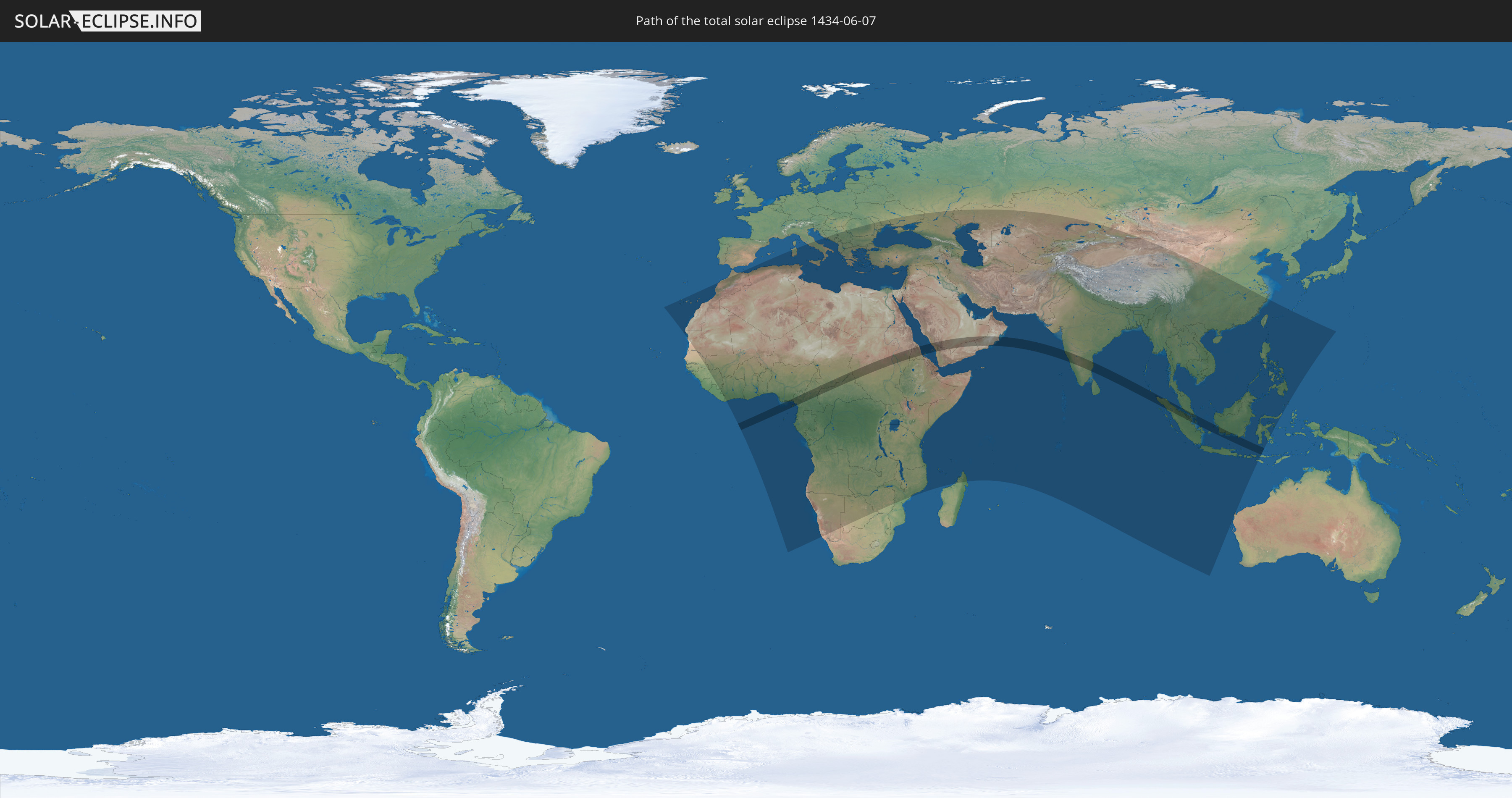
Die Sonnenfinsternis am 06/07/1434 kann man in 116 Ländern als partielle Sonnenfinsternis beobachten.
Der Finsternispfad verläuft durch 14 Länder. Nur in diesen Ländern ist sie als total Sonnenfinsternis zu sehen.
In den folgenden Ländern ist die Sonnenfinsternis total zu sehen
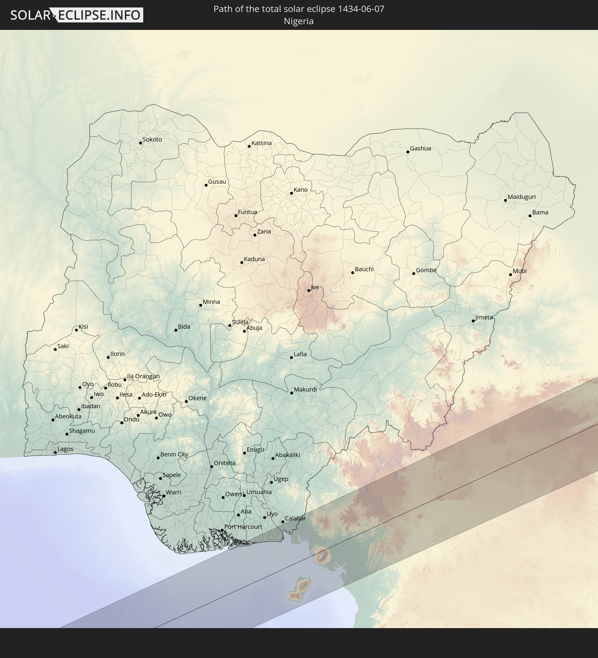 Nigeria
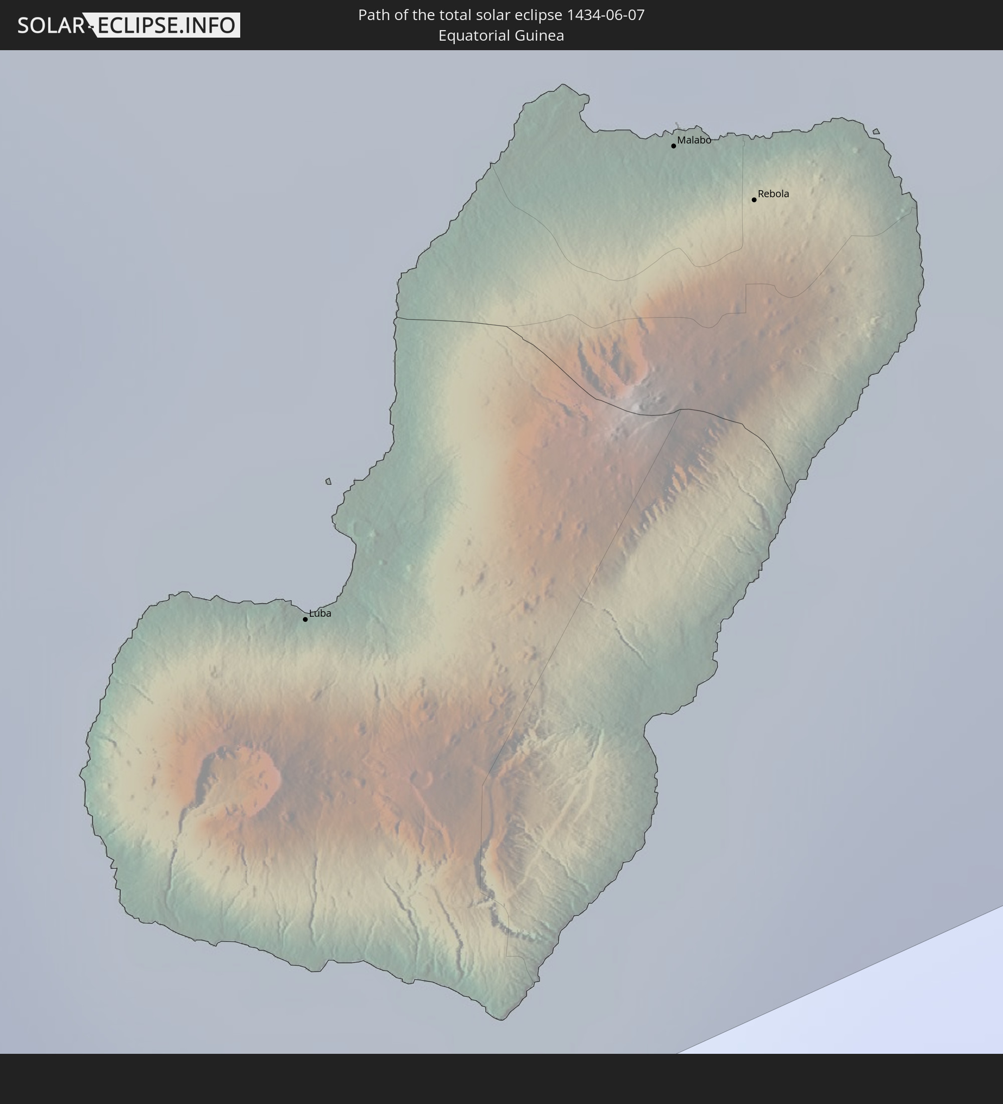 Equatorial Guinea
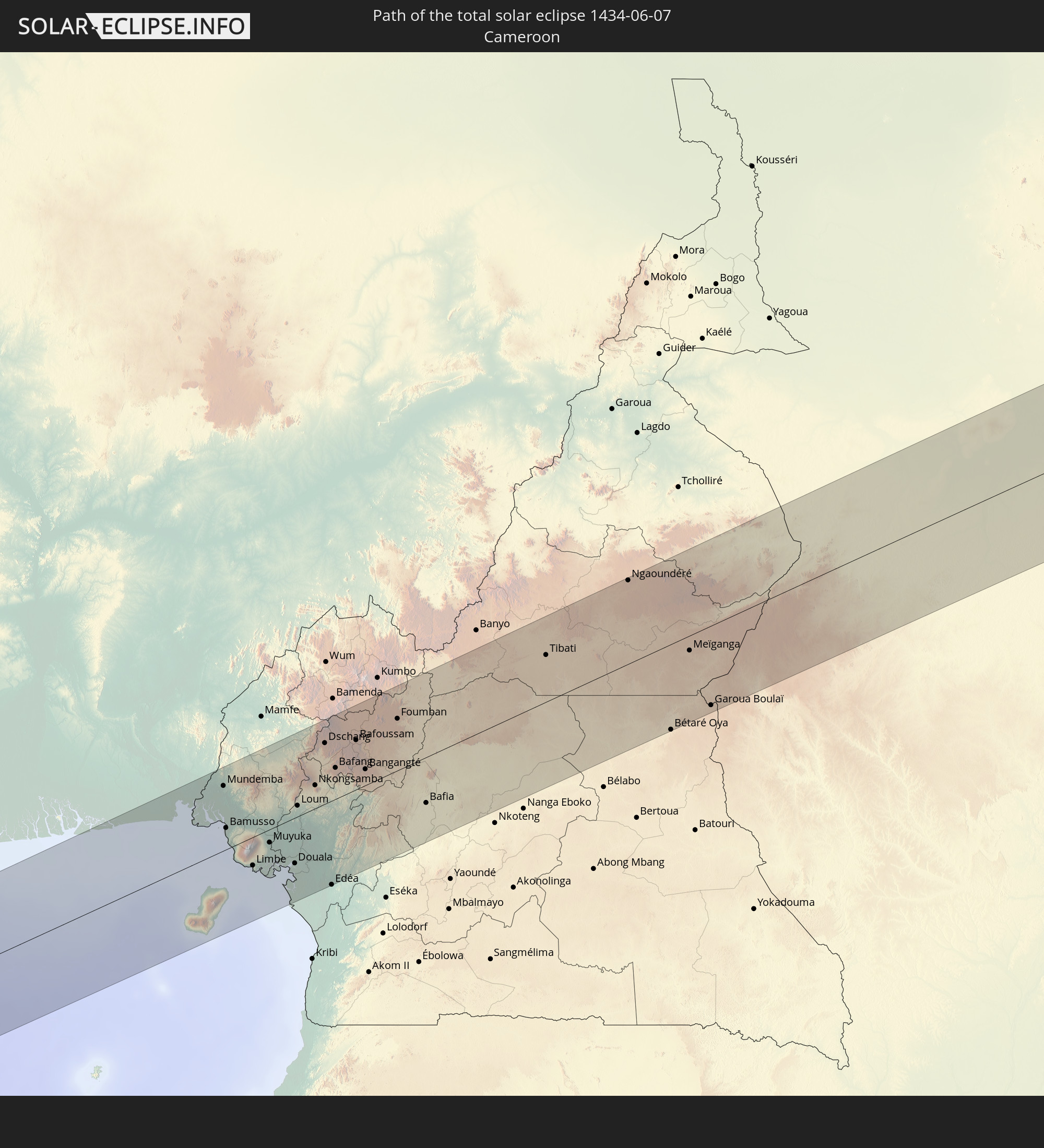 Cameroon
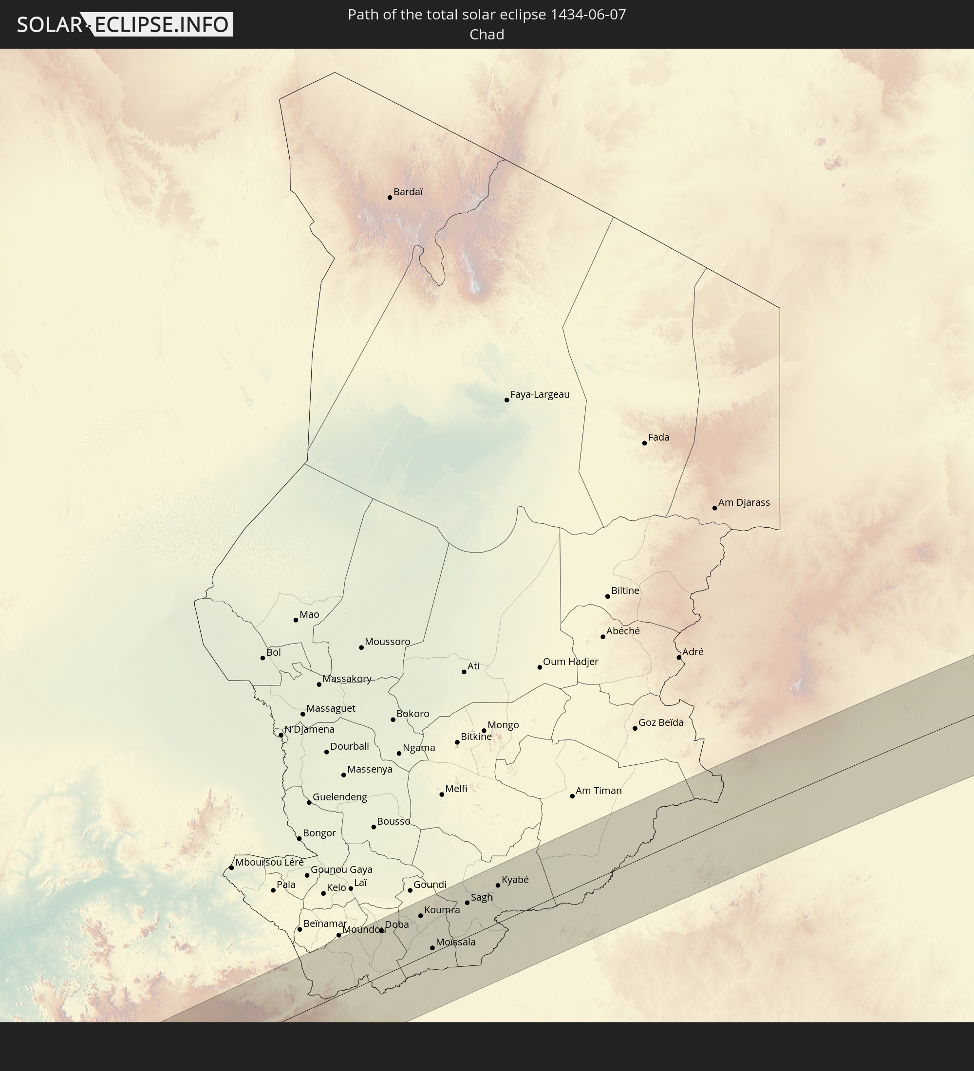 Chad
Chad
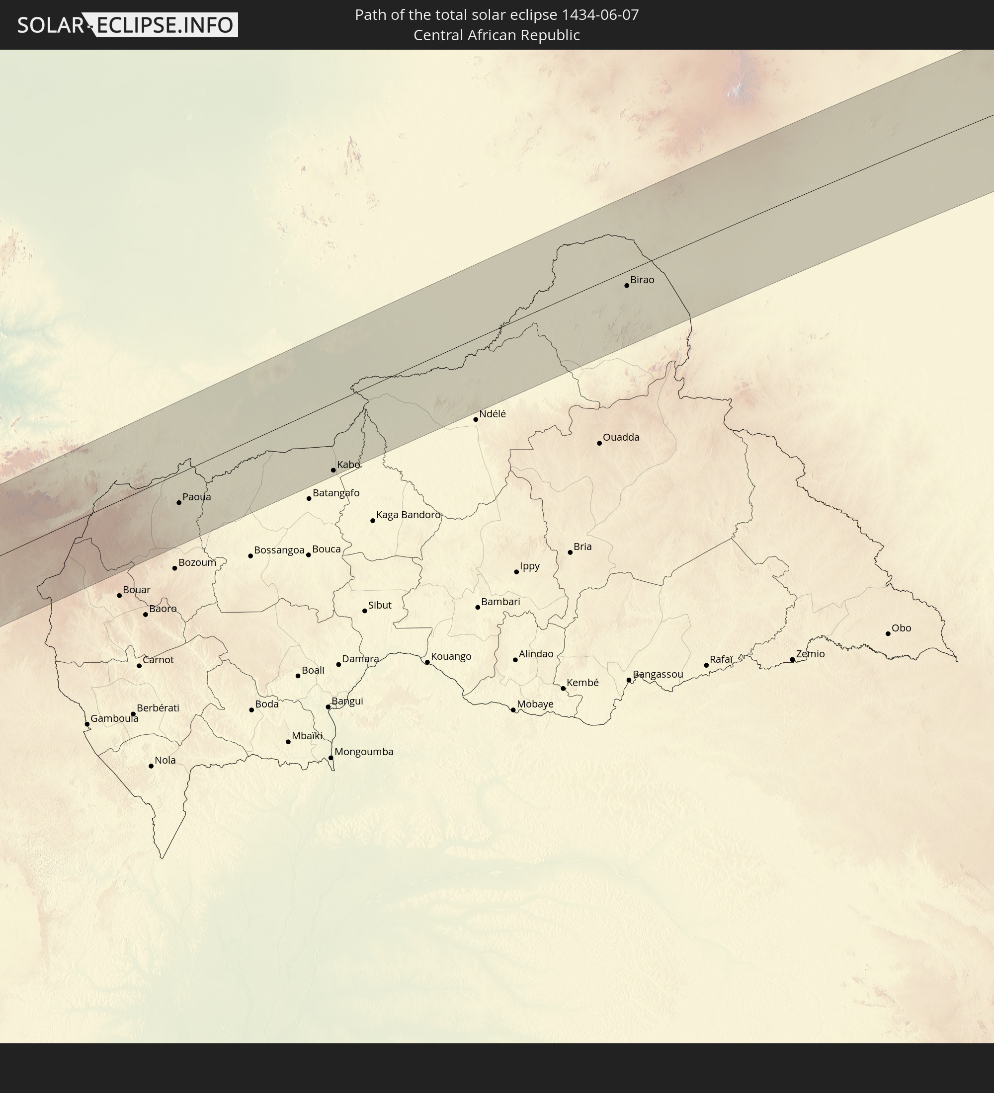 Central African Republic
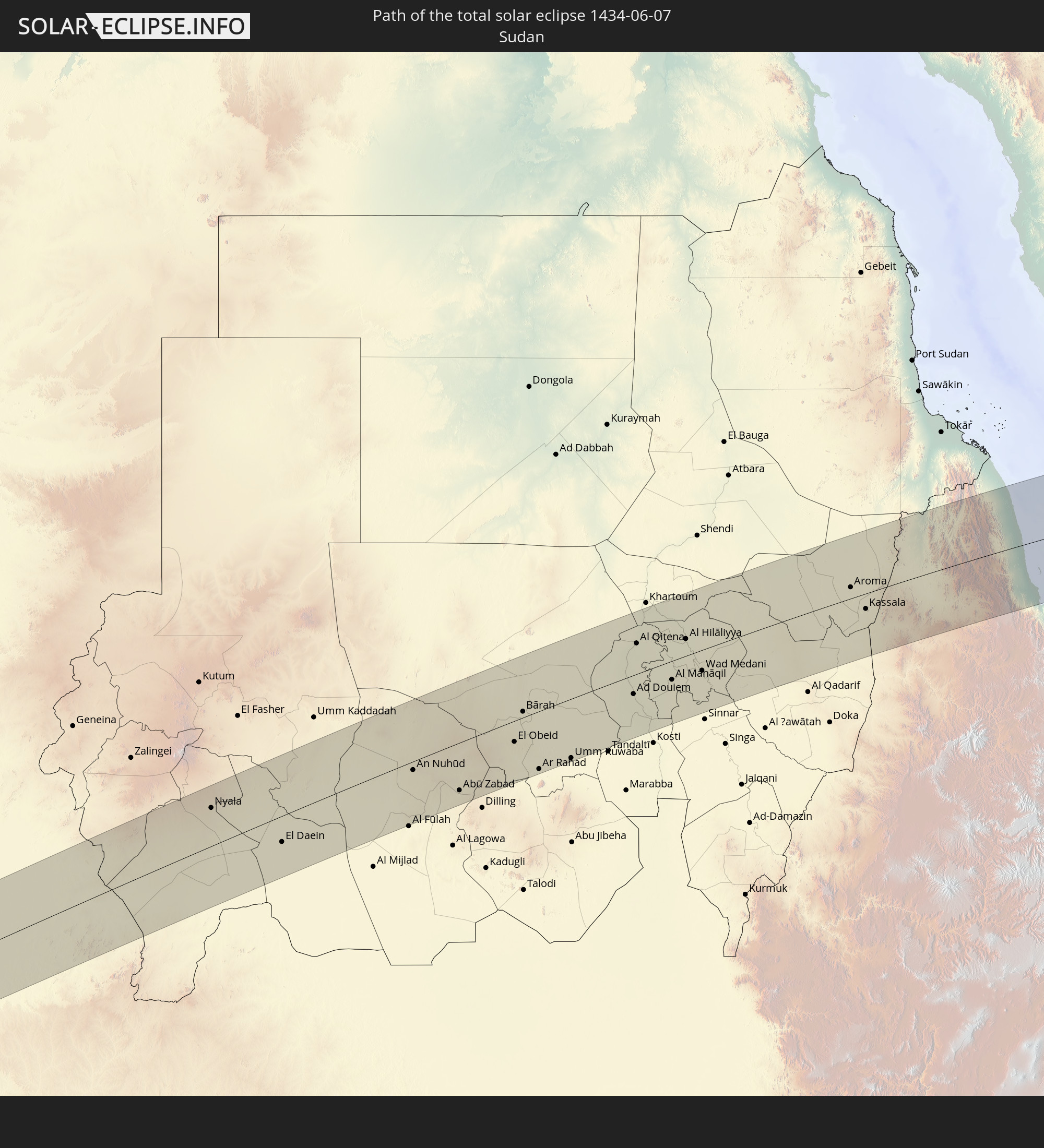 Sudan
Sudan
 Saudi Arabia
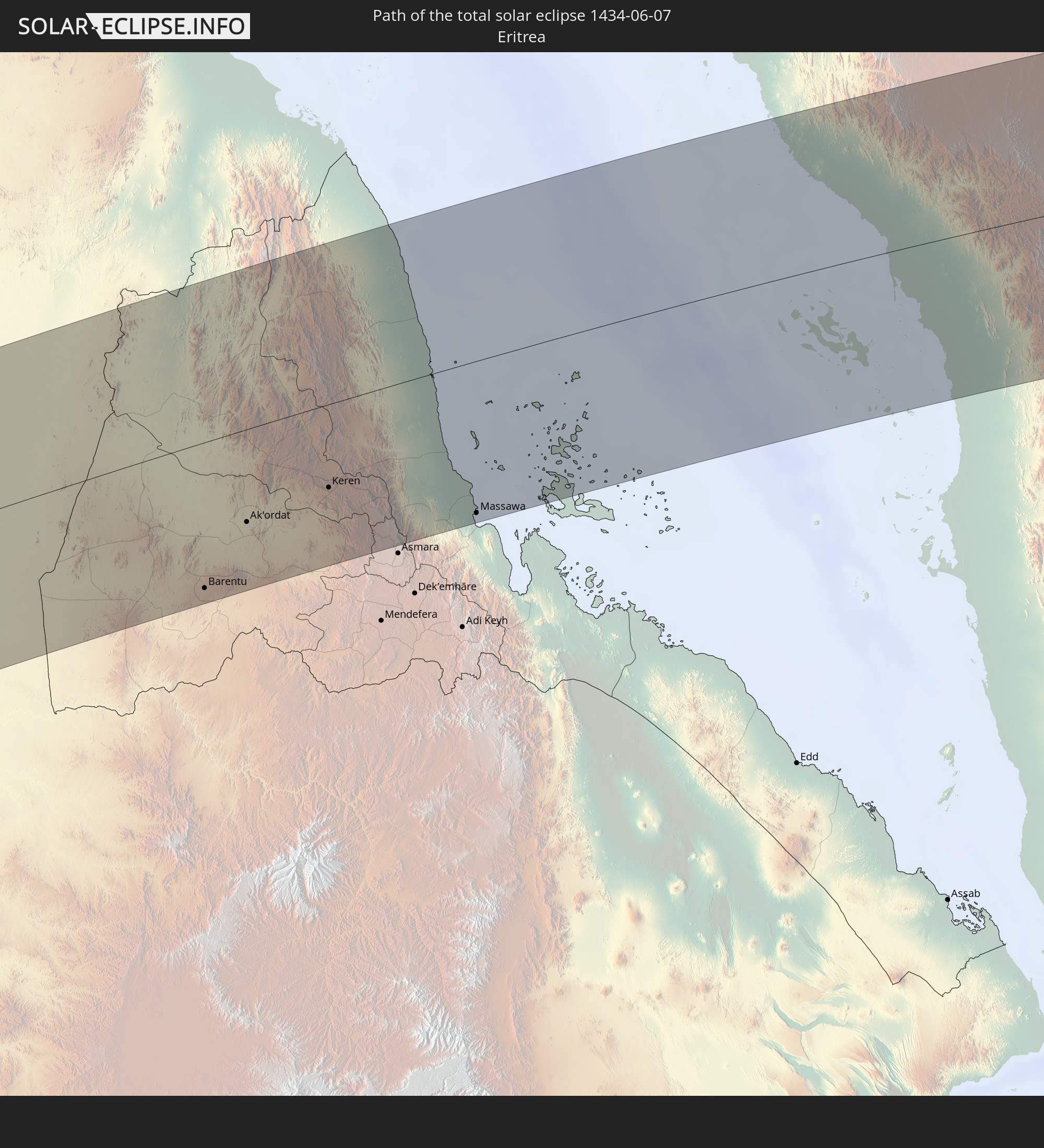 Eritrea
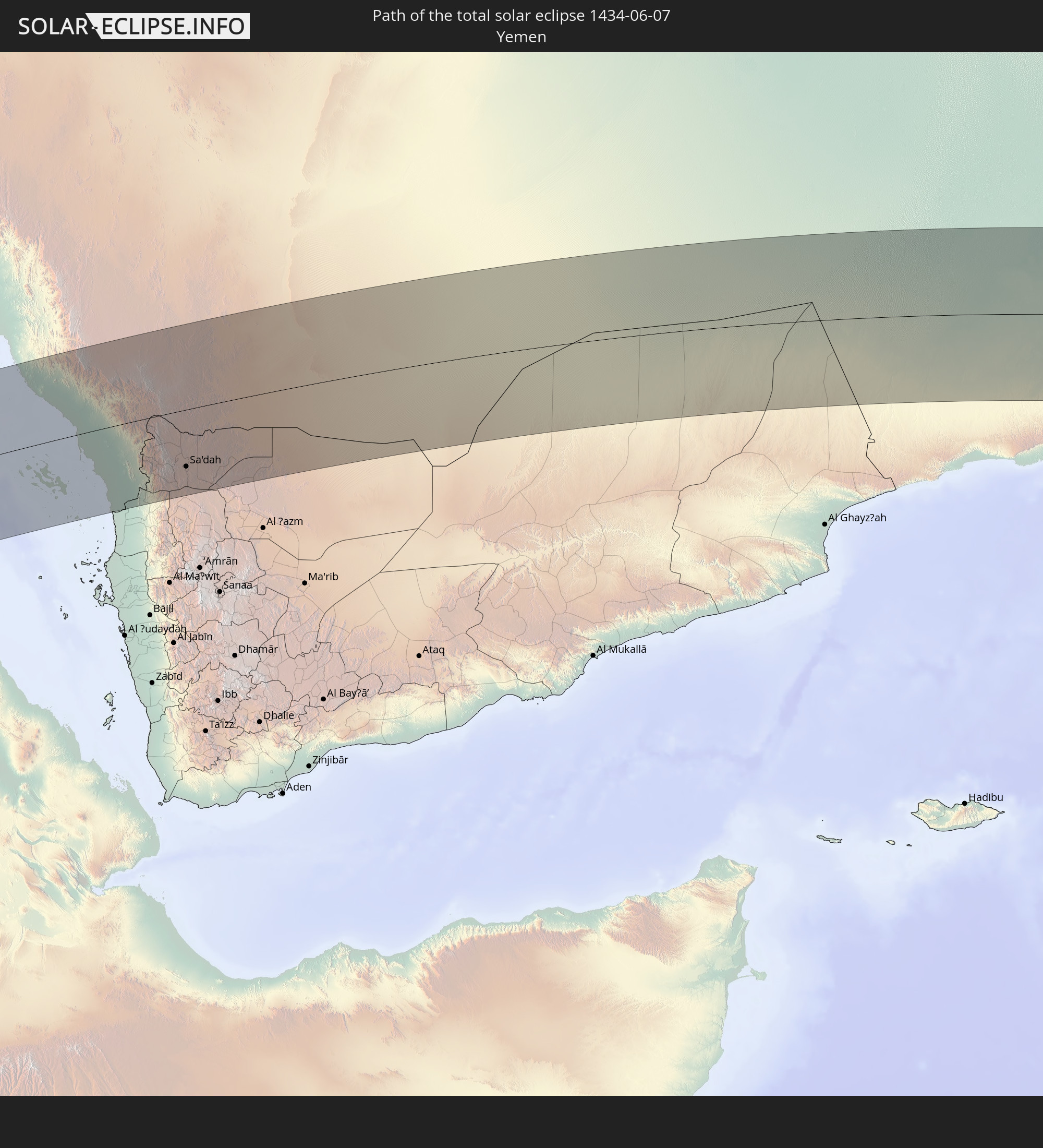 Yemen
Yemen
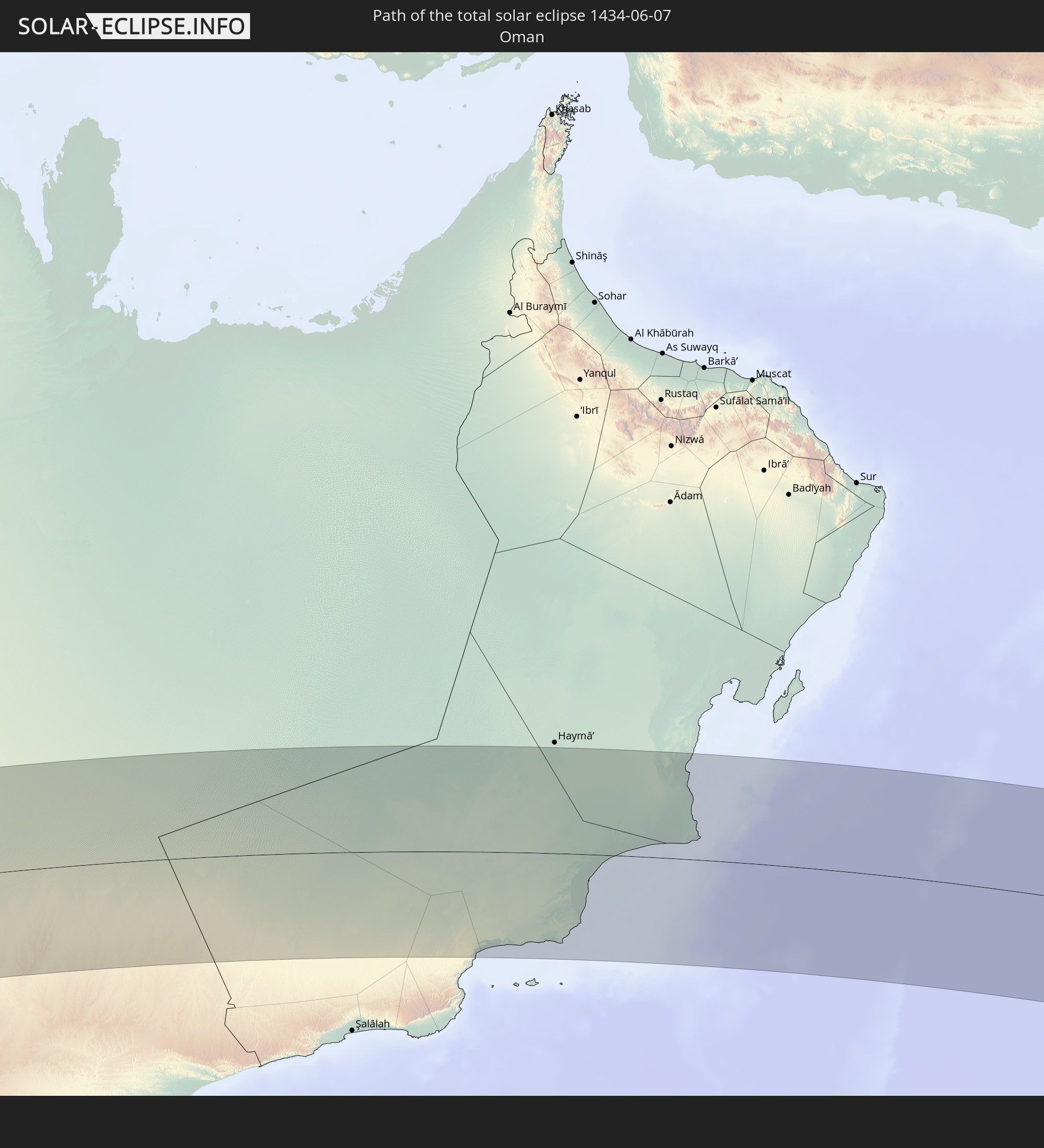 Oman
Oman
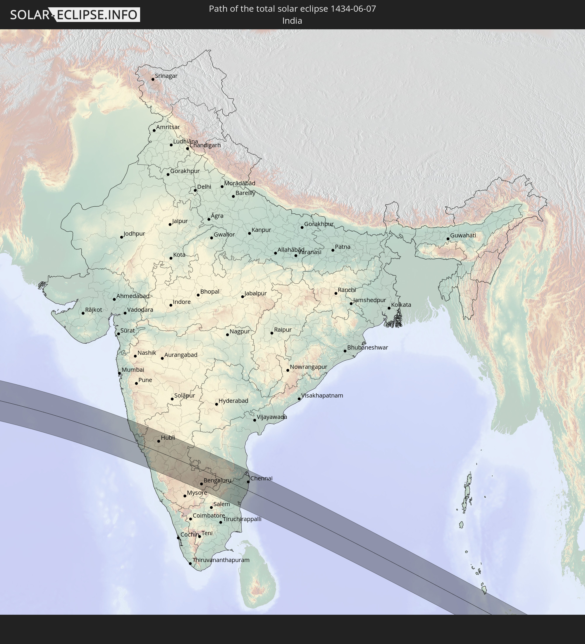 India
India
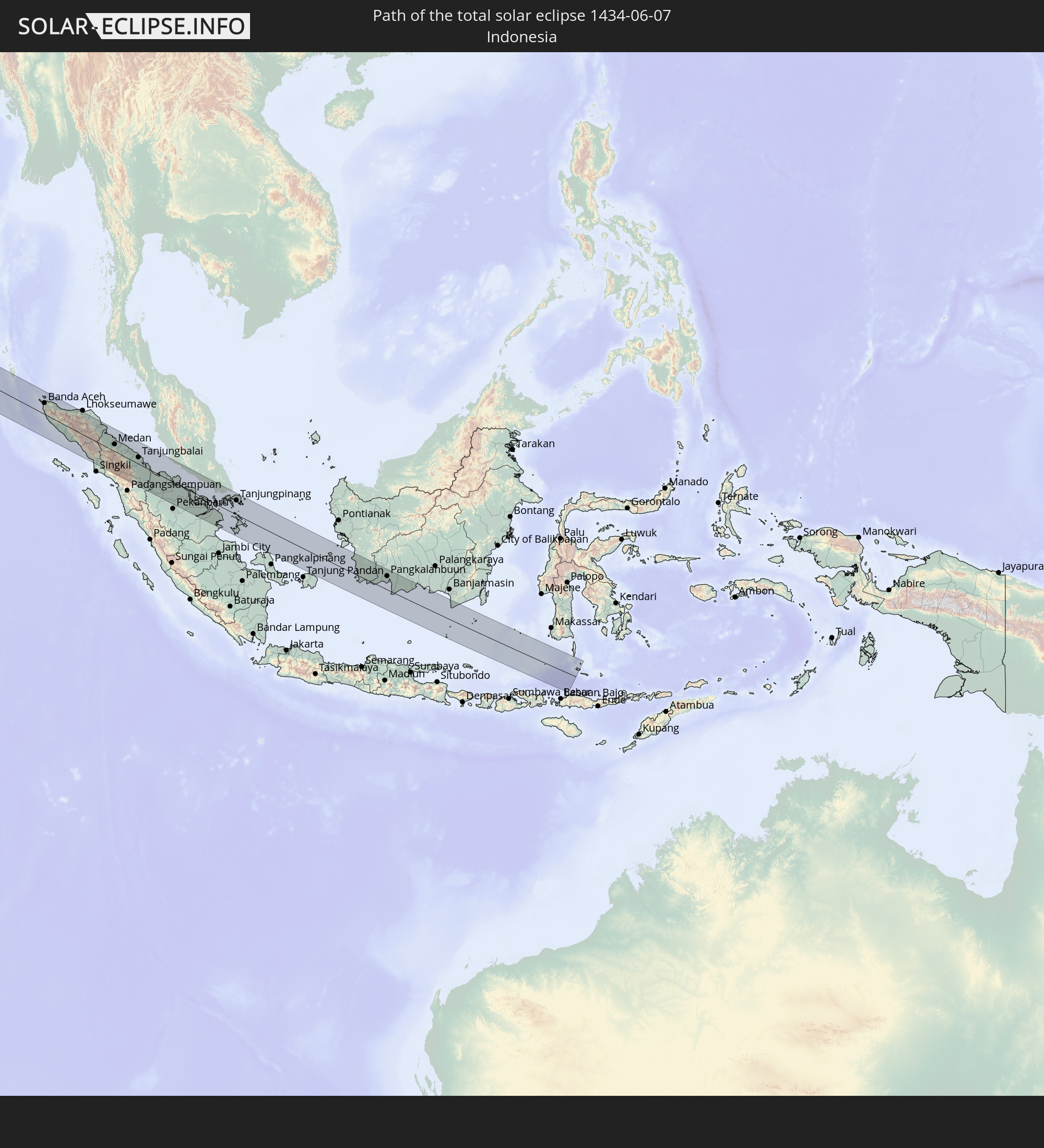 Indonesia
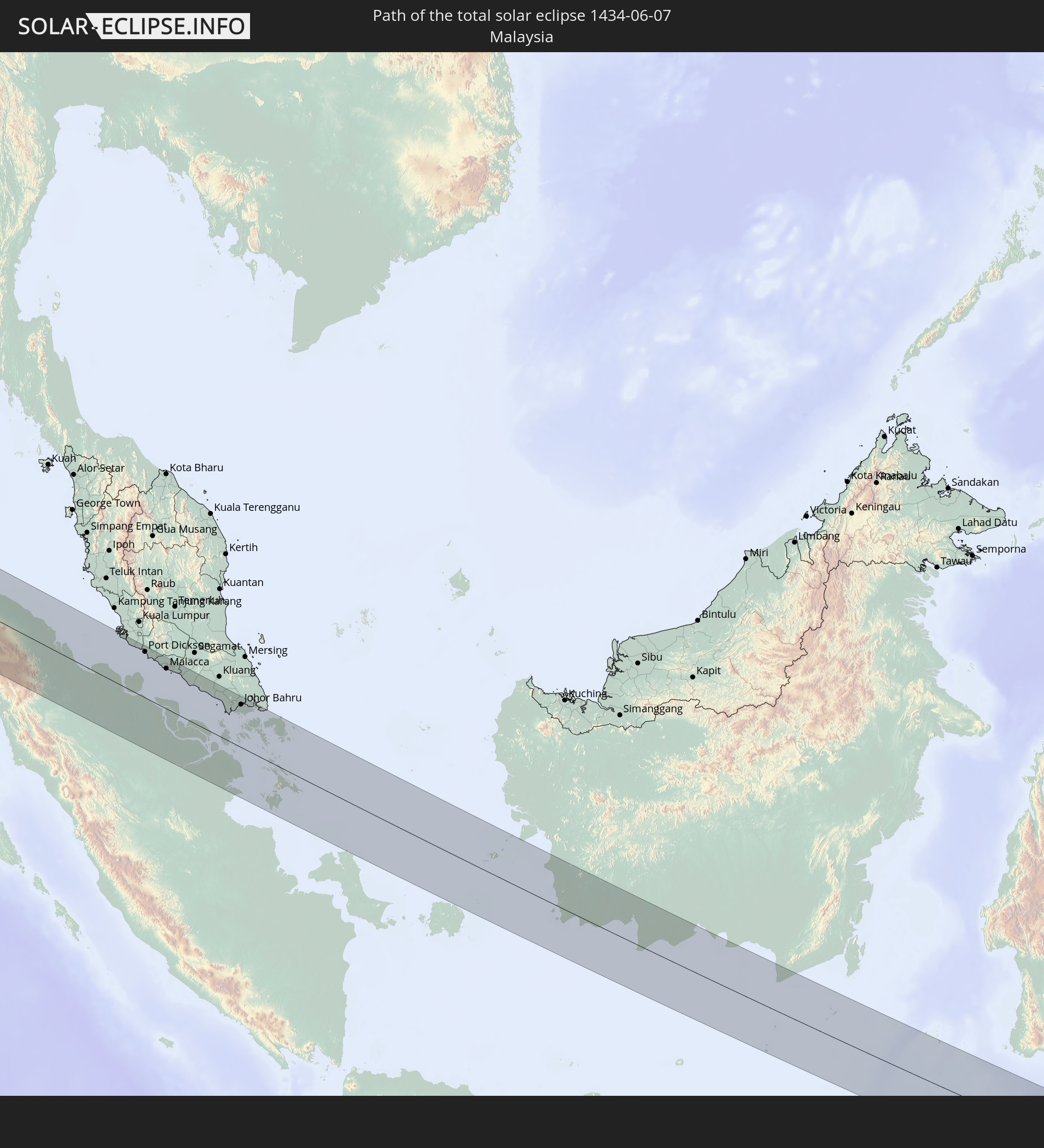 Malaysia
 Singapore
In den folgenden Ländern ist die Sonnenfinsternis partiell zu sehen
 Russia
 Spain
Spain
 Senegal
 Mauritania
 Guinea
 Morocco
 Mali
Mali
 Liberia
 Algeria
 Ivory Coast
 Burkina Faso
 Ghana
Ghana
 Togo
Togo
 Niger
Niger
 Benin
Benin
 Nigeria
 Equatorial Guinea
 São Tomé and Príncipe
 Italy
Italy
 Tunisia
 Cameroon
 Gabon
Gabon
 Libya
Libya
 Republic of the Congo
 Angola
 Namibia
 Democratic Republic of the Congo
 Vatican City
 Chad
Chad
 Croatia
 Malta
Malta
 Central African Republic
 Bosnia and Herzegovina
 South Africa
 Montenegro
 Serbia
 Albania
 Greece
 Botswana
 Romania
 Republic of Macedonia
 Sudan
Sudan
 Zambia
 Ukraine
 Bulgaria
 Egypt
Egypt
 Zimbabwe
 Turkey
 Moldova
 Rwanda
 Burundi
 Tanzania
 Uganda
 Mozambique
 Cyprus
 Malawi
 Ethiopia
 Kenya
Kenya
 State of Palestine
 Israel
 Saudi Arabia
 Jordan
 Lebanon
 Syria
Syria
 Eritrea
 Iraq
Iraq
 Georgia
 French Southern and Antarctic Lands
 Somalia
 Djibouti
 Yemen
Yemen
 Madagascar
 Comoros
 Armenia
 Iran
Iran
 Azerbaijan
 Mayotte
 Seychelles
 Kazakhstan
 Kuwait
 Bahrain
 Qatar
Qatar
 United Arab Emirates
 Oman
Oman
 Turkmenistan
 Uzbekistan
 Mauritius
 Afghanistan
 Pakistan
 Tajikistan
 India
India
 Kyrgyzstan
 British Indian Ocean Territory
 Maldives
 China
China
 Sri Lanka
 Nepal
Nepal
 Bangladesh
 Bhutan
 Myanmar
 Indonesia
 Cocos Islands
 Thailand
 Malaysia
 Laos
Laos
 Vietnam
 Cambodia
 Singapore
 Christmas Island
 Australia
 Macau
Macau
 Hong Kong
 Brunei
 Taiwan
 Philippines
 Japan
Japan
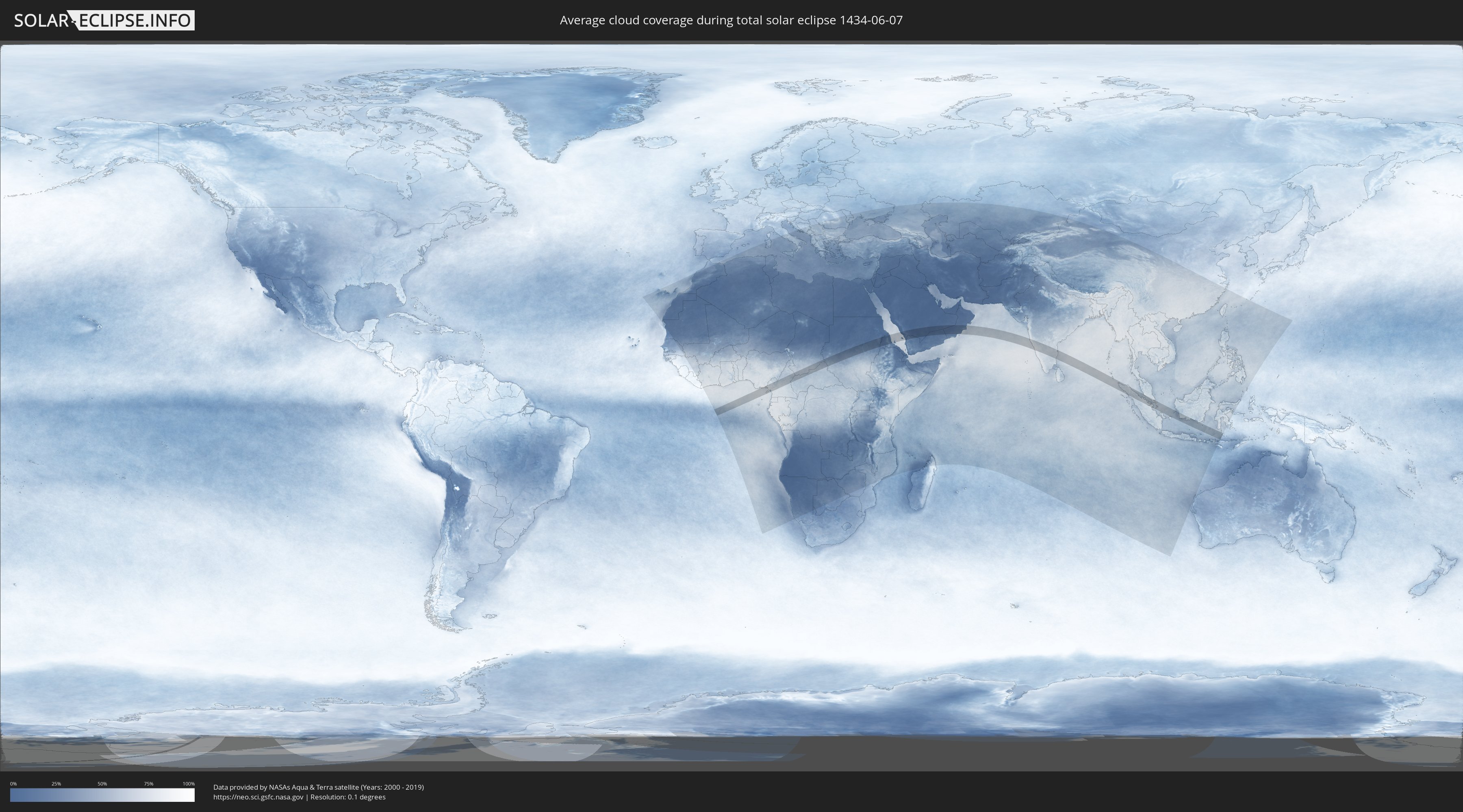
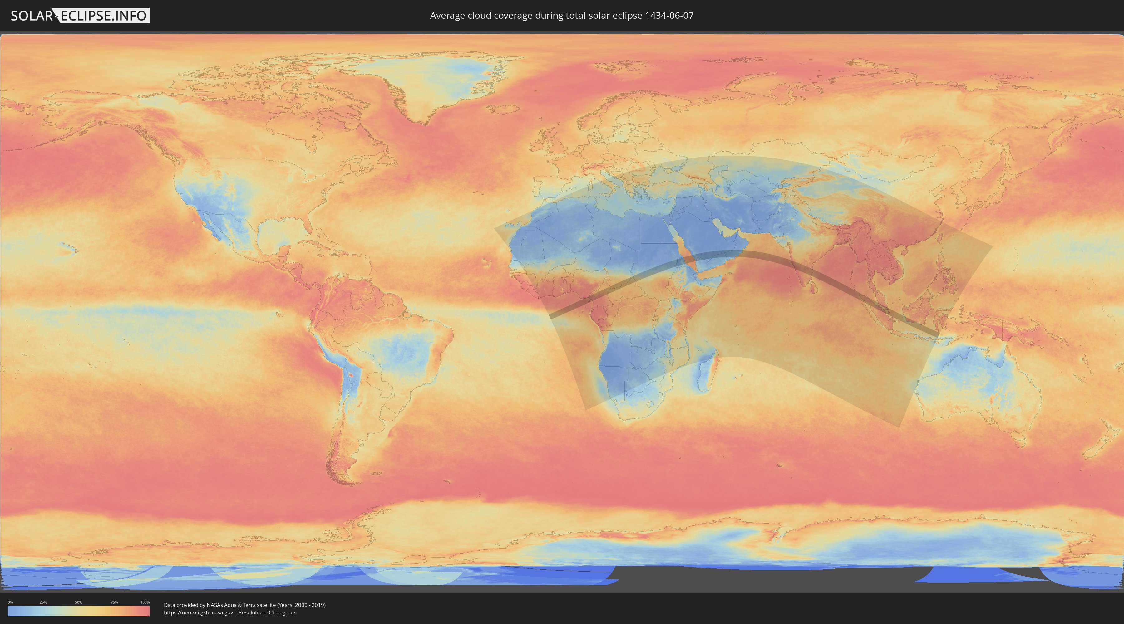
How will be the weather during the total solar eclipse on 06/07/1434?
Where is the best place to see the total solar eclipse of 06/07/1434?
The following maps show the average cloud coverage for the day of the total solar eclipse.
With the help of these maps, it is possible to find the place along the eclipse path, which has the best
chance of a cloudless sky.
Nevertheless, you should consider local circumstances and inform about the weather of your chosen
observation site.
The data is provided by NASAs satellites
AQUA and TERRA.
The cloud maps are averaged over a period of 19 years (2000 - 2019).
Detailed country maps
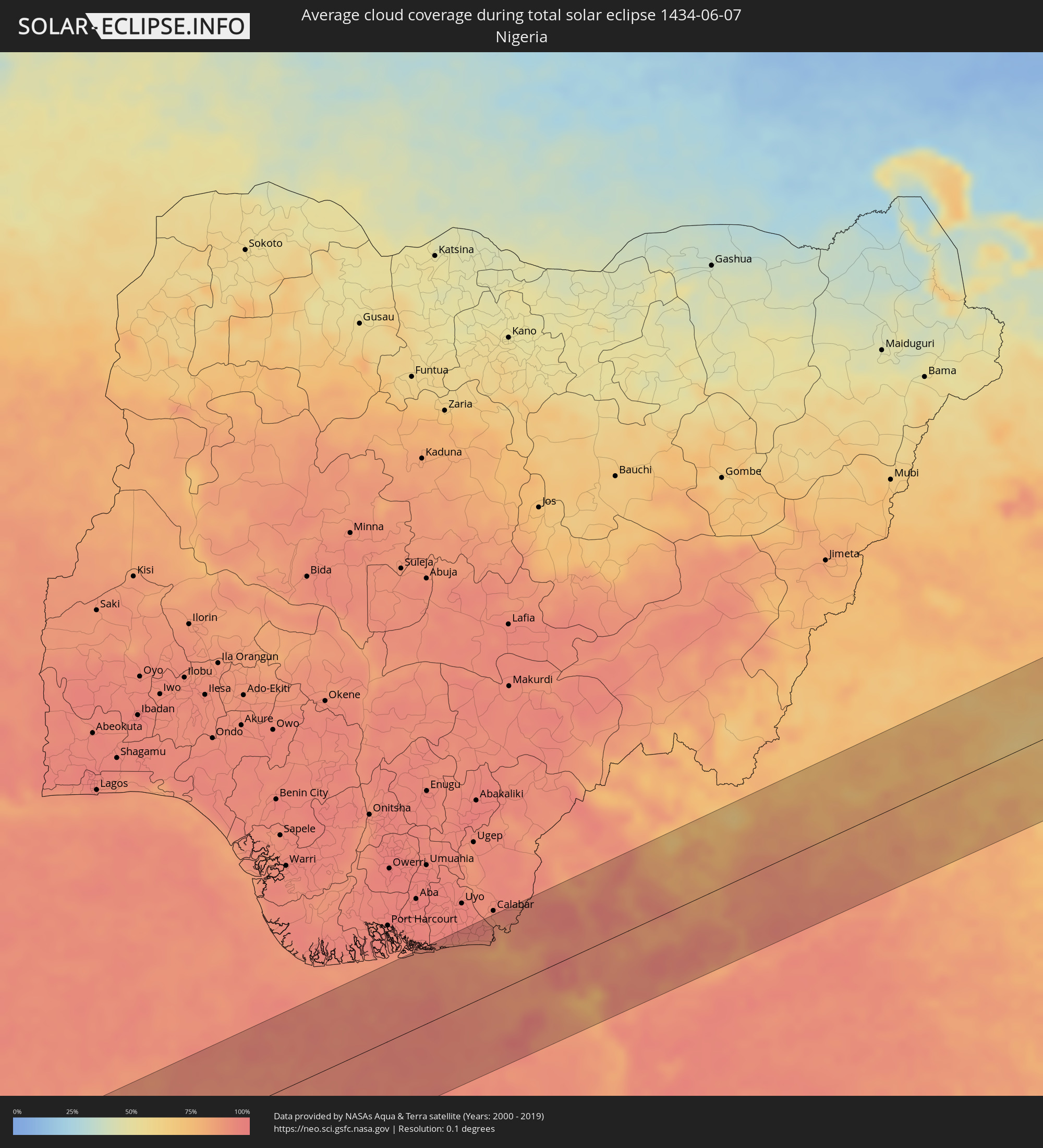 Nigeria
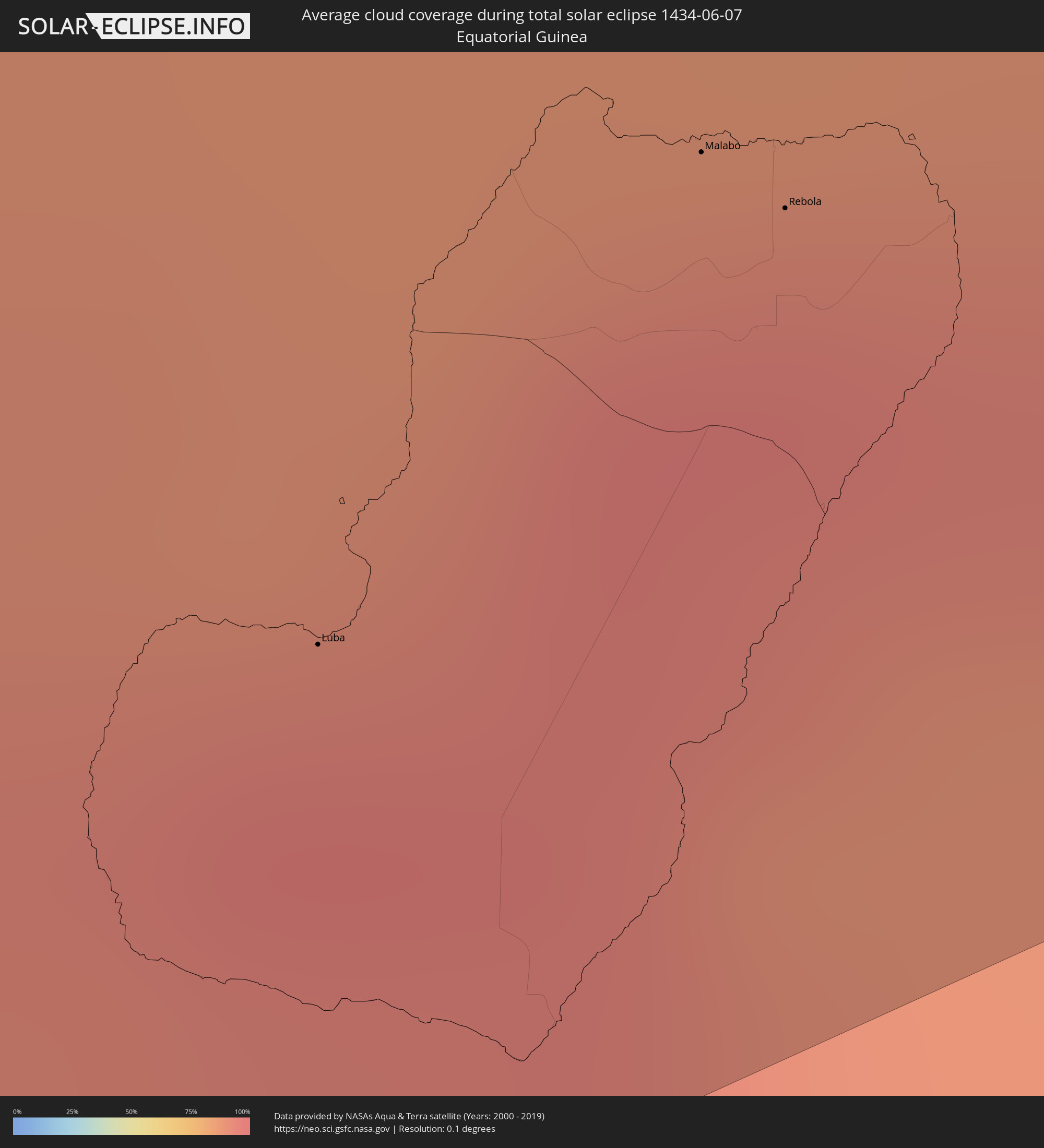 Equatorial Guinea
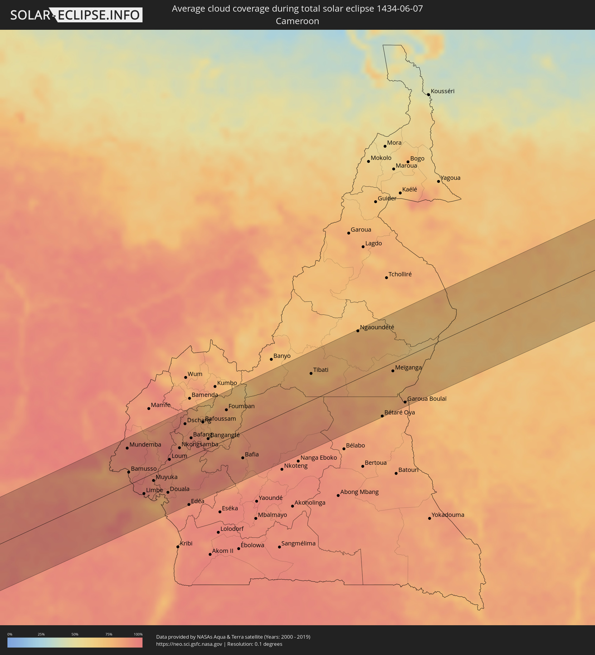 Cameroon
 Chad
Chad
 Central African Republic
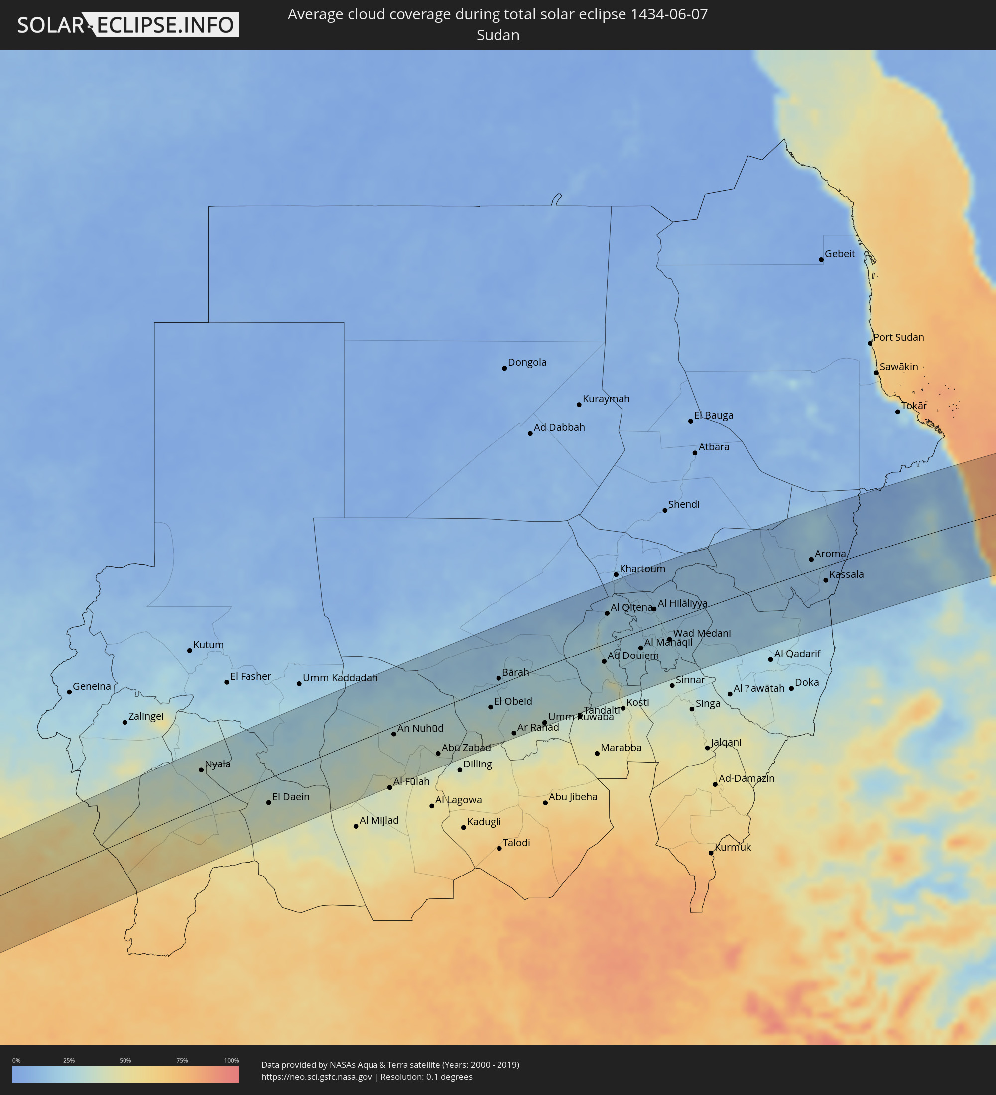 Sudan
Sudan
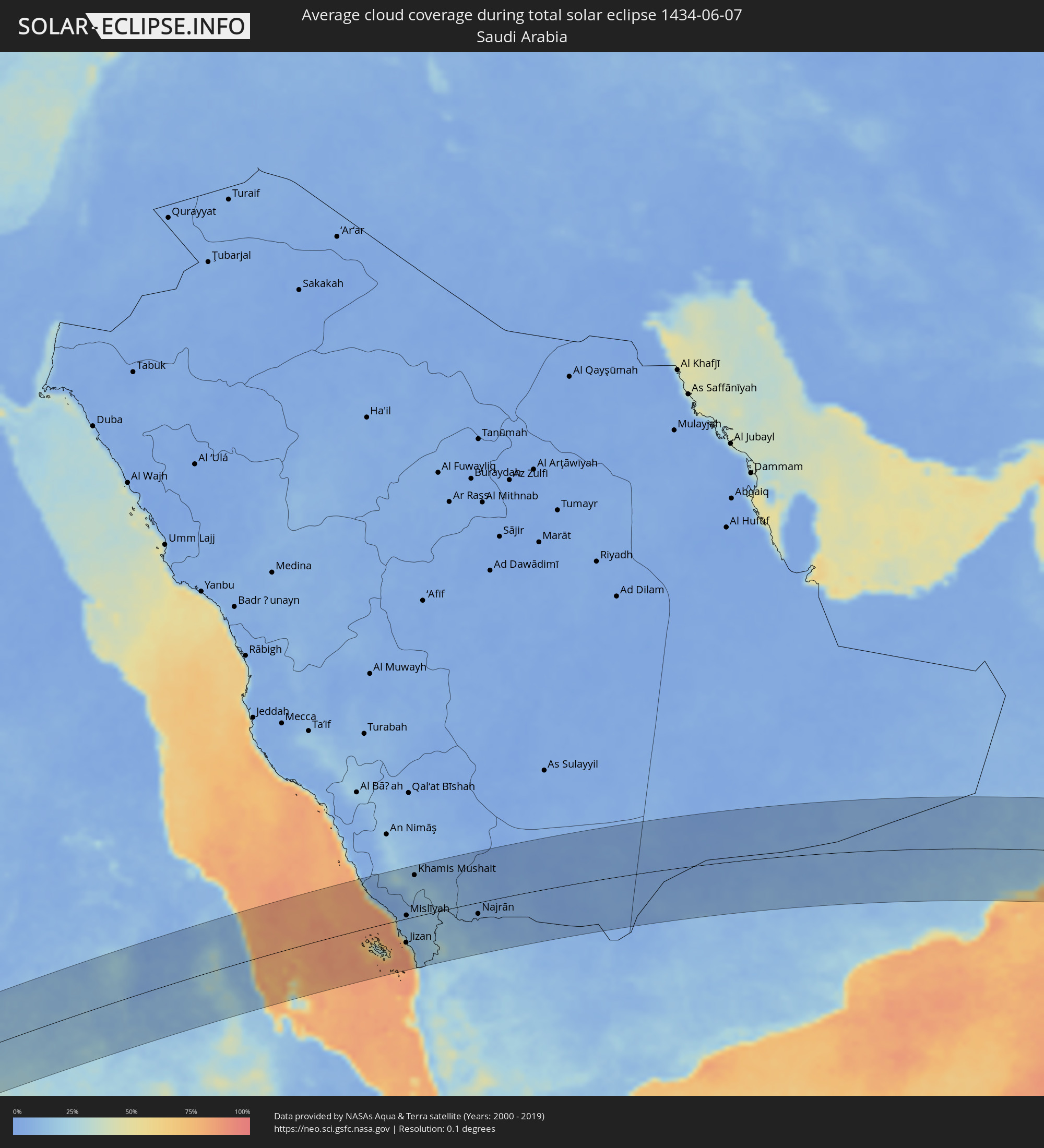 Saudi Arabia
 Eritrea
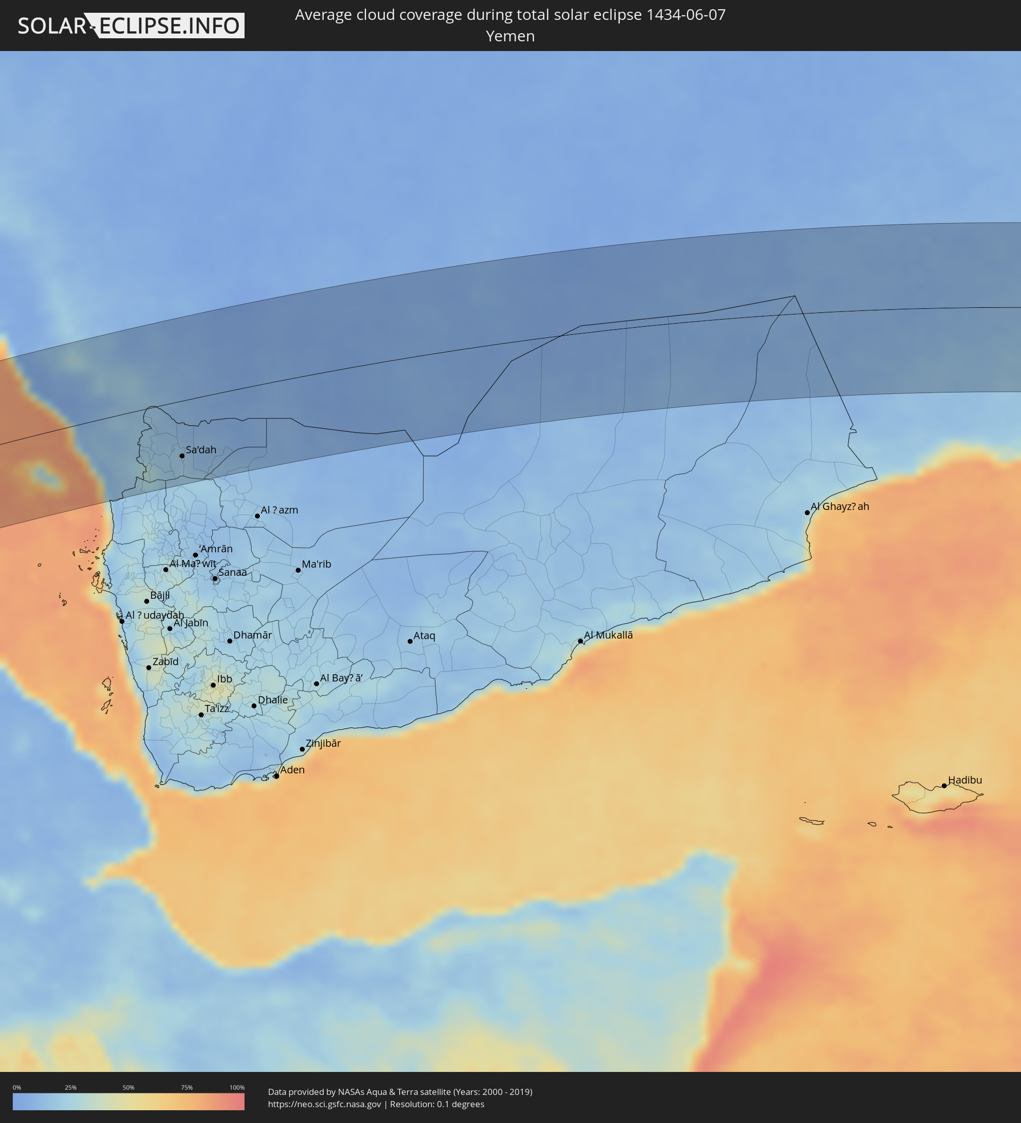 Yemen
Yemen
 Oman
Oman
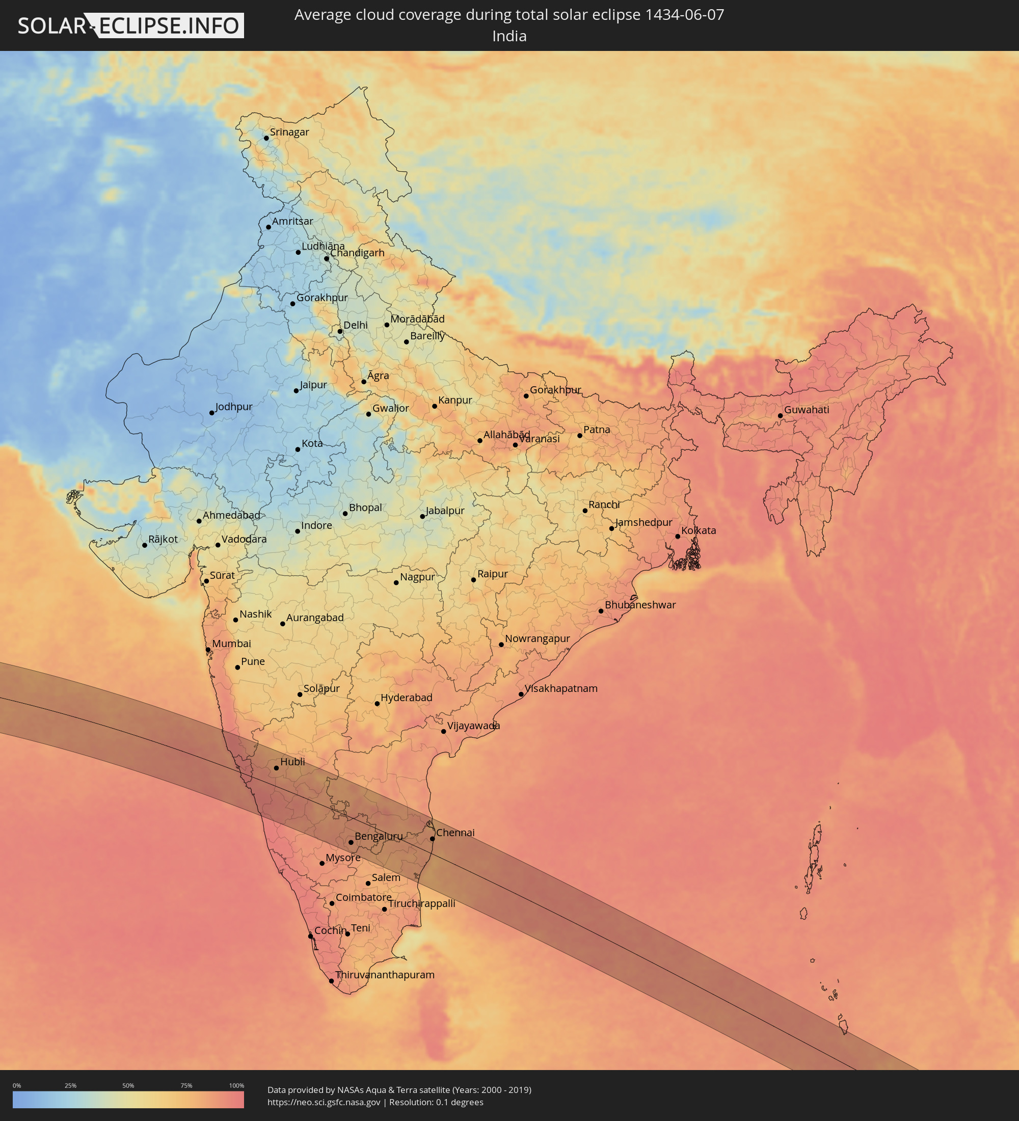 India
India
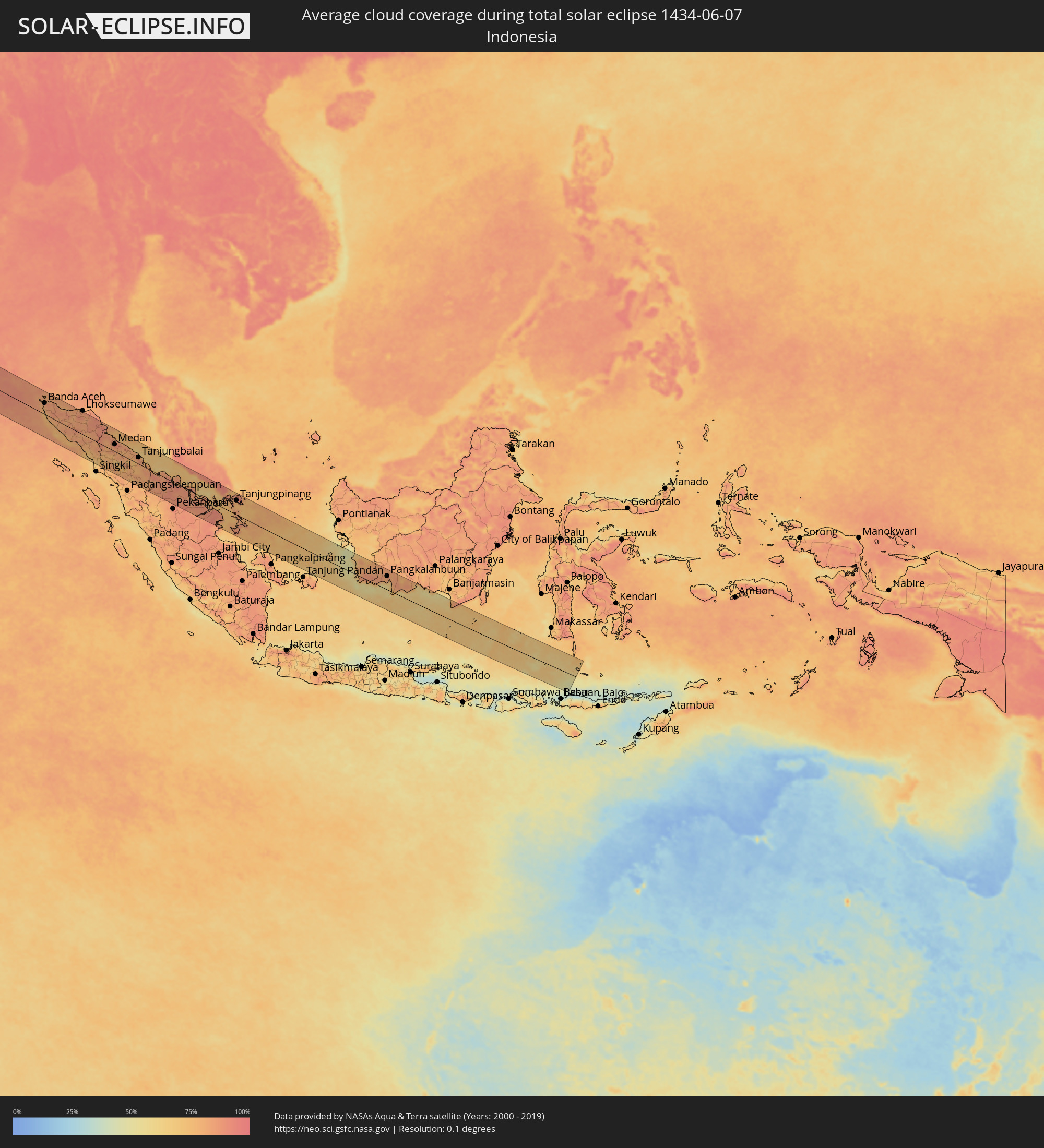 Indonesia
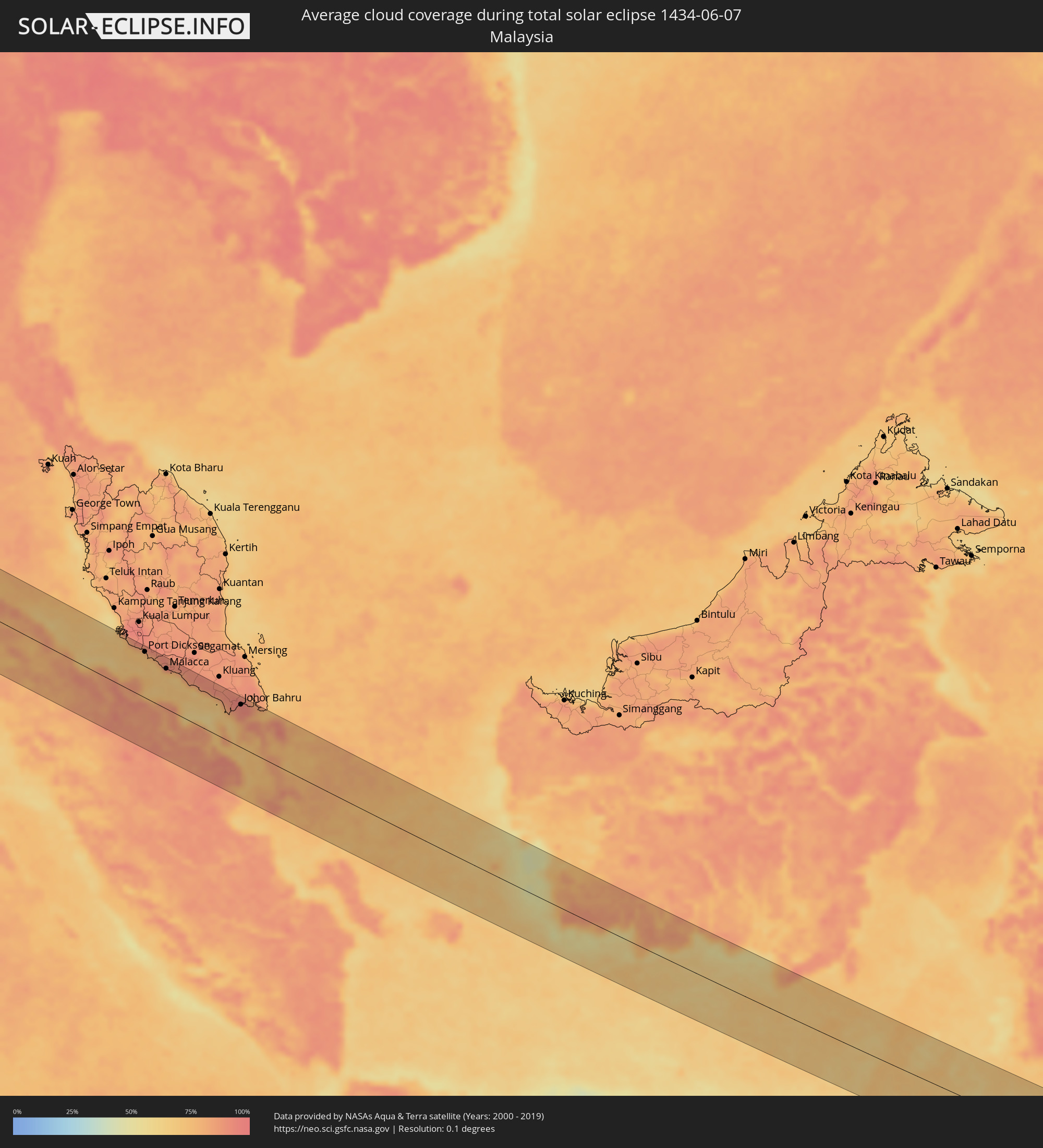 Malaysia
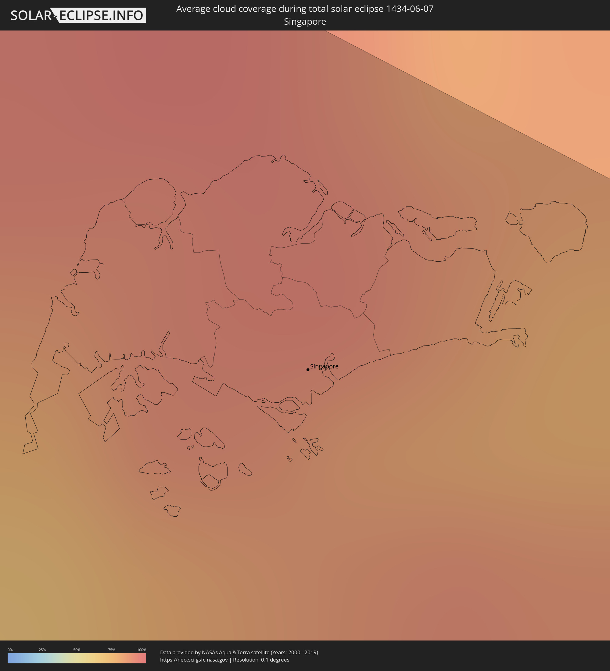 Singapore
Cities inside the path of the eclipse
The following table shows all locations with a population of more than 5,000 inside the eclipse path. Cities which have more than 100,000 inhabitants are marked bold. A click at the locations opens a detailed map.
| City | Type | Eclipse duration | Local time of max. eclipse | Distance to central line | Ø Cloud coverage |
|
Eket, Akwa Ibom
|
total | - | 06:34:34 UTC+00:13 | 89 km | 89% |
|
Esuk Oron, Akwa Ibom
|
total | - | 06:34:45 UTC+00:13 | 90 km | 91% |
|
Ikang, Cross River
|
total | - | 06:34:51 UTC+00:13 | 76 km | 87% |
|
Luba, Bioko Sur
|
total | - | 06:34:21 UTC+00:13 | 60 km | 94% |
|
Malabo, Bioko Norte
|
total | - | 06:34:33 UTC+00:13 | 41 km | 91% |
|
Rebola, Bioko Norte
|
total | - | 06:34:33 UTC+00:13 | 47 km | 96% |
|
Limbe, South-West
|
total | - | 06:34:49 UTC+00:13 | 33 km | 83% |
|
Kumba, South-West
|
total | - | 06:35:09 UTC+00:13 | 18 km | 91% |
|
Douala, Littoral
|
total | - | 06:35:02 UTC+00:13 | 54 km | 84% |
|
Loum, Littoral
|
total | - | 06:35:19 UTC+00:13 | 13 km | 91% |
|
Nkongsamba, Littoral
|
total | - | 06:35:30 UTC+00:13 | 27 km | 92% |
|
Dschang, West
|
total | - | 06:35:45 UTC+00:13 | 71 km | 88% |
|
Edéa, Littoral
|
total | - | 06:35:08 UTC+00:13 | 99 km | 89% |
|
Bafang, West
|
total | - | 06:35:41 UTC+00:13 | 37 km | 91% |
|
Mbouda, West
|
total | - | 06:35:56 UTC+00:13 | 80 km | 80% |
|
Bafoussam, West
|
total | - | 06:35:56 UTC+00:13 | 58 km | 81% |
|
Bangangté, West
|
total | - | 06:35:50 UTC+00:13 | 19 km | 88% |
|
Foumbot, West
|
total | - | 06:36:03 UTC+00:13 | 51 km | 77% |
|
Foumban, West
|
total | - | 06:36:16 UTC+00:13 | 61 km | 79% |
|
Bafia, Centre
|
total | - | 06:36:01 UTC+00:13 | 54 km | 88% |
|
Ngaoundéré, Adamaoua
|
total | - | 06:38:30 UTC+00:13 | 98 km | 76% |
|
Meïganga, Adamaoua
|
total | - | 06:38:33 UTC+00:13 | 17 km | 75% |
|
Paoua, Ouham-Pendé
|
total | - | 06:40:23 UTC+00:13 | 43 km | 73% |
|
Bébédja, Logone Oriental
|
total | - | 07:27:52 UTC+01:00 | 96 km | 73% |
|
Doba, Logone Oriental
|
total | - | 07:28:04 UTC+01:00 | 81 km | 74% |
|
Béboto, Logone Oriental
|
total | - | 07:27:56 UTC+01:00 | 38 km | 75% |
|
Koumra, Mandoul
|
total | - | 07:28:47 UTC+01:00 | 75 km | 76% |
|
Moïssala, Mandoul
|
total | - | 07:28:38 UTC+01:00 | 7 km | 71% |
|
Sagh, Moyen-Chari
|
total | - | 07:29:36 UTC+01:00 | 60 km | 73% |
|
Kabo, Ouham
|
total | - | 06:42:23 UTC+00:13 | 97 km | 68% |
|
Kyabé, Moyen-Chari
|
total | - | 07:30:16 UTC+01:00 | 66 km | 71% |
|
Birao, Vakaga
|
total | - | 06:47:58 UTC+00:13 | 21 km | 61% |
|
El Daein, Eastern Darfur
|
total | - | 08:49:17 UTC+02:10 | 46 km | 38% |
|
An Nuhūd, West Kordofan State
|
total | - | 08:53:18 UTC+02:10 | 15 km | 35% |
|
Abū Zabad, West Kordofan State
|
total | - | 08:54:16 UTC+02:10 | 85 km | 35% |
|
El Obeid, North Kordofan
|
total | - | 08:56:20 UTC+02:10 | 37 km | 29% |
|
Bārah, North Kordofan
|
total | - | 08:56:55 UTC+02:10 | 10 km | 22% |
|
Ar Rahad, North Kordofan
|
total | - | 08:56:42 UTC+02:10 | 103 km | 39% |
|
Umm Ruwaba, North Kordofan
|
total | - | 08:57:45 UTC+02:10 | 105 km | 37% |
|
Ad Douiem, White Nile
|
total | - | 09:00:20 UTC+02:10 | 34 km | 31% |
|
Al Qiţena, White Nile
|
total | - | 09:01:02 UTC+02:10 | 54 km | 23% |
|
Al Manāqil, Al Jazīrah
|
total | - | 09:01:41 UTC+02:10 | 34 km | 24% |
|
Kināna, Sinnār
|
total | - | 09:01:52 UTC+02:10 | 62 km | 24% |
|
Al Hilāliyya, Al Jazīrah
|
total | - | 09:02:36 UTC+02:10 | 30 km | 18% |
|
Al Hasaheisa, Al Jazīrah
|
total | - | 09:02:35 UTC+02:10 | 8 km | 24% |
|
Wad Medani, Al Jazīrah
|
total | - | 09:02:45 UTC+02:10 | 37 km | 23% |
|
Aroma, Kassala
|
total | - | 09:08:38 UTC+02:10 | 20 km | 18% |
|
Kassala, Kassala
|
total | - | 09:08:56 UTC+02:10 | 28 km | 17% |
|
Barentu, Gash-Barka
|
total | - | 09:28:16 UTC+02:27 | 103 km | 14% |
|
Ak’ordat, Gash-Barka
|
total | - | 09:29:10 UTC+02:27 | 66 km | 14% |
|
Keren, Anseba
|
total | - | 09:30:31 UTC+02:27 | 59 km | 25% |
|
Massawa, Northern Red Sea
|
total | - | 09:32:39 UTC+02:27 | 108 km | 49% |
|
Farasān, Jizan
|
total | - | 10:19:00 UTC+03:06 | 64 km | 45% |
|
Ad Darb, Jizan
|
total | - | 10:19:53 UTC+03:06 | 43 km | 6% |
|
Abha, 'Asir
|
total | - | 10:20:45 UTC+03:06 | 90 km | 21% |
|
Jizan, Jizan
|
total | - | 10:20:09 UTC+03:06 | 54 km | 44% |
|
Mislīyah, Jizan
|
total | - | 10:20:28 UTC+03:06 | 7 km | 12% |
|
Şabyā, Jizan
|
total | - | 10:20:28 UTC+03:06 | 28 km | 15% |
|
Mizhirah, Jizan
|
total | - | 10:20:33 UTC+03:06 | 66 km | 37% |
|
Khamis Mushait, 'Asir
|
total | - | 10:21:21 UTC+03:06 | 94 km | 15% |
|
Abū ‘Arīsh, Jizan
|
total | - | 10:20:52 UTC+03:06 | 53 km | 14% |
|
Al Jarādīyah, Jizan
|
total | - | 10:20:52 UTC+03:06 | 97 km | 14% |
|
Şāmitah, Jizan
|
total | - | 10:20:57 UTC+03:06 | 96 km | 14% |
|
Sa'dah, Şa‘dah
|
total | - | 10:23:09 UTC+03:06 | 78 km | 21% |
|
Najrān, Najran
|
total | - | 10:24:20 UTC+03:06 | 26 km | 9% |
|
Belgaum, Karnataka
|
total | - | 14:05:35 UTC+05:21 | 87 km | 87% |
|
Hubli, Karnataka
|
total | - | 14:07:31 UTC+05:21 | 59 km | 86% |
|
Shimoga, Karnataka
|
total | - | 14:09:50 UTC+05:21 | 70 km | 91% |
|
Gadag, Karnataka
|
total | - | 14:08:35 UTC+05:21 | 87 km | 82% |
|
Bhadrāvati, Karnataka
|
total | - | 14:10:14 UTC+05:21 | 73 km | 90% |
|
Hospet, Karnataka
|
total | - | 14:10:26 UTC+05:21 | 101 km | 80% |
|
Bellary, Karnataka
|
total | - | 14:11:44 UTC+05:21 | 110 km | 76% |
|
Tumkūr, Karnataka
|
total | - | 14:13:51 UTC+05:21 | 66 km | 88% |
|
Bengaluru, Karnataka
|
total | - | 14:15:16 UTC+05:21 | 83 km | 84% |
|
Anantapur, Andhra Pradesh
|
total | - | 14:13:40 UTC+05:21 | 92 km | 82% |
|
Vellore, Tamil Nadu
|
total | - | 14:18:34 UTC+05:21 | 21 km | 83% |
|
Tirupati, Andhra Pradesh
|
total | - | 14:18:28 UTC+05:21 | 65 km | 83% |
|
Cuddalore, Tamil Nadu
|
total | - | 14:20:58 UTC+05:21 | 111 km | 77% |
|
Puducherry, Pondicherry
|
total | - | 14:20:55 UTC+05:21 | 89 km | 83% |
|
Āvadi, Tamil Nadu
|
total | - | 14:20:21 UTC+05:21 | 43 km | 83% |
|
Chennai, Tamil Nadu
|
total | - | 14:20:42 UTC+05:21 | 48 km | 84% |
|
Banda Aceh, Aceh
|
total | - | 16:35:20 UTC+07:07 | 52 km | 82% |
|
Langsa, Aceh
|
total | - | 16:38:30 UTC+07:07 | 84 km | 90% |
|
Binjai, North Sumatra
|
total | - | 16:39:30 UTC+07:07 | 25 km | 86% |
|
Kabanjahe, North Sumatra
|
total | - | 16:39:50 UTC+07:07 | 24 km | 75% |
|
Medan, North Sumatra
|
total | - | 16:39:40 UTC+07:07 | 33 km | 91% |
|
Belawan, North Sumatra
|
total | - | 16:39:33 UTC+07:07 | 53 km | 84% |
|
Percut, North Sumatra
|
total | - | 16:39:47 UTC+07:07 | 47 km | 86% |
|
Pematangsiantar, North Sumatra
|
total | - | 16:40:23 UTC+07:07 | 8 km | 83% |
|
Tebingtinggi, North Sumatra
|
total | - | 16:40:13 UTC+07:07 | 33 km | 81% |
|
Kisaran, North Sumatra
|
total | - | 16:40:47 UTC+07:07 | 23 km | 84% |
|
Tanjungbalai, North Sumatra
|
total | - | 16:40:56 UTC+07:07 | 31 km | 81% |
|
Rantauprapat, North Sumatra
|
total | - | 16:41:29 UTC+07:07 | 53 km | 82% |
|
Balaipungut, Riau
|
total | - | 16:43:05 UTC+07:07 | 80 km | 88% |
|
Dumai, Riau
|
total | - | 16:42:51 UTC+07:07 | 13 km | 90% |
|
Banting, Selangor
|
total | - | 16:30:26 UTC+06:55 | 104 km | 83% |
|
Tanjung Sepat, Selangor
|
total | - | 16:30:34 UTC+06:55 | 91 km | 78% |
|
Port Dickson, Negeri Sembilan
|
total | - | 16:30:48 UTC+06:55 | 92 km | 72% |
|
Kampong Masjid Tanah, Melaka
|
total | - | 16:31:06 UTC+06:55 | 89 km | 83% |
|
Sungai Udang, Melaka
|
total | - | 16:31:10 UTC+06:55 | 83 km | 72% |
|
Alor Gajah, Melaka
|
total | - | 16:31:09 UTC+06:55 | 97 km | 91% |
|
Malacca, Melaka
|
total | - | 16:31:16 UTC+06:55 | 81 km | 73% |
|
Batu Berendam, Melaka
|
total | - | 16:31:15 UTC+06:55 | 86 km | 73% |
|
Muar, Johor
|
total | - | 16:31:34 UTC+06:55 | 82 km | 74% |
|
Bakri, Johor
|
total | - | 16:31:37 UTC+06:55 | 87 km | 84% |
|
Batu Pahat, Johor
|
total | - | 16:31:53 UTC+06:55 | 82 km | 84% |
|
Pontian Kechil, Johor
|
total | - | 16:32:21 UTC+06:55 | 69 km | 78% |
|
Pekan Nenas, Johor
|
total | - | 16:32:25 UTC+06:55 | 78 km | 87% |
|
Taman Senai, Johor
|
total | - | 16:32:26 UTC+06:55 | 93 km | 94% |
|
Johor Bahru, Johor
|
total | - | 16:32:34 UTC+06:55 | 86 km | 93% |
|
Ulu Tiram, Johor
|
total | - | 16:32:32 UTC+06:55 | 102 km | 95% |
|
Singapore, Central Singapore
|
total | - | 16:32:43 UTC+06:55 | 73 km | 82% |
|
Tanjungpinang, Riau Islands
|
total | - | 16:45:01 UTC+07:07 | 67 km | 86% |
|
Kijang, Riau Islands
|
total | - | 16:45:07 UTC+07:07 | 74 km | 88% |