Total solar eclipse of 06/21/1610
| Day of week: | Monday |
| Maximum duration of eclipse: | 05m59s |
| Maximum width of eclipse path: | 400 km |
| Saros cycle: | 111 |
| Coverage: | 100% |
| Magnitude: | 1.0705 |
| Gamma: | -0.8193 |
Wo kann man die Sonnenfinsternis vom 06/21/1610 sehen?

Die Sonnenfinsternis am 06/21/1610 kann man in 23 Ländern als partielle Sonnenfinsternis beobachten.
Der Finsternispfad verläuft durch 2 Länder. Nur in diesen Ländern ist sie als total Sonnenfinsternis zu sehen.
In den folgenden Ländern ist die Sonnenfinsternis total zu sehen
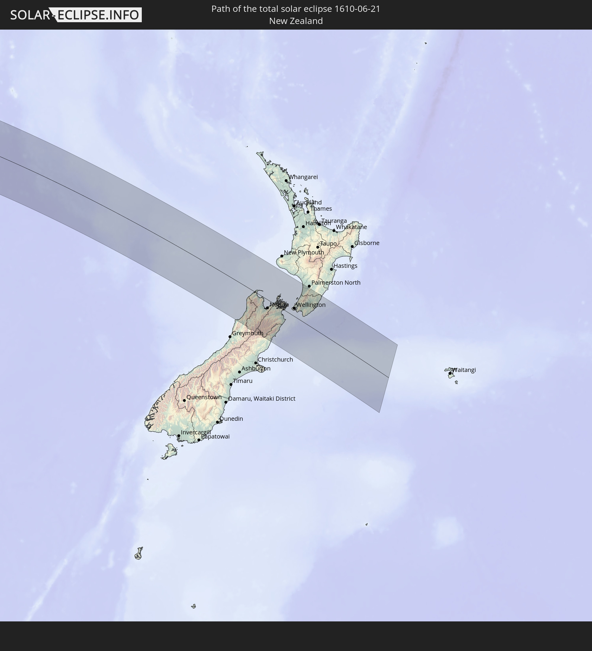 New Zealand
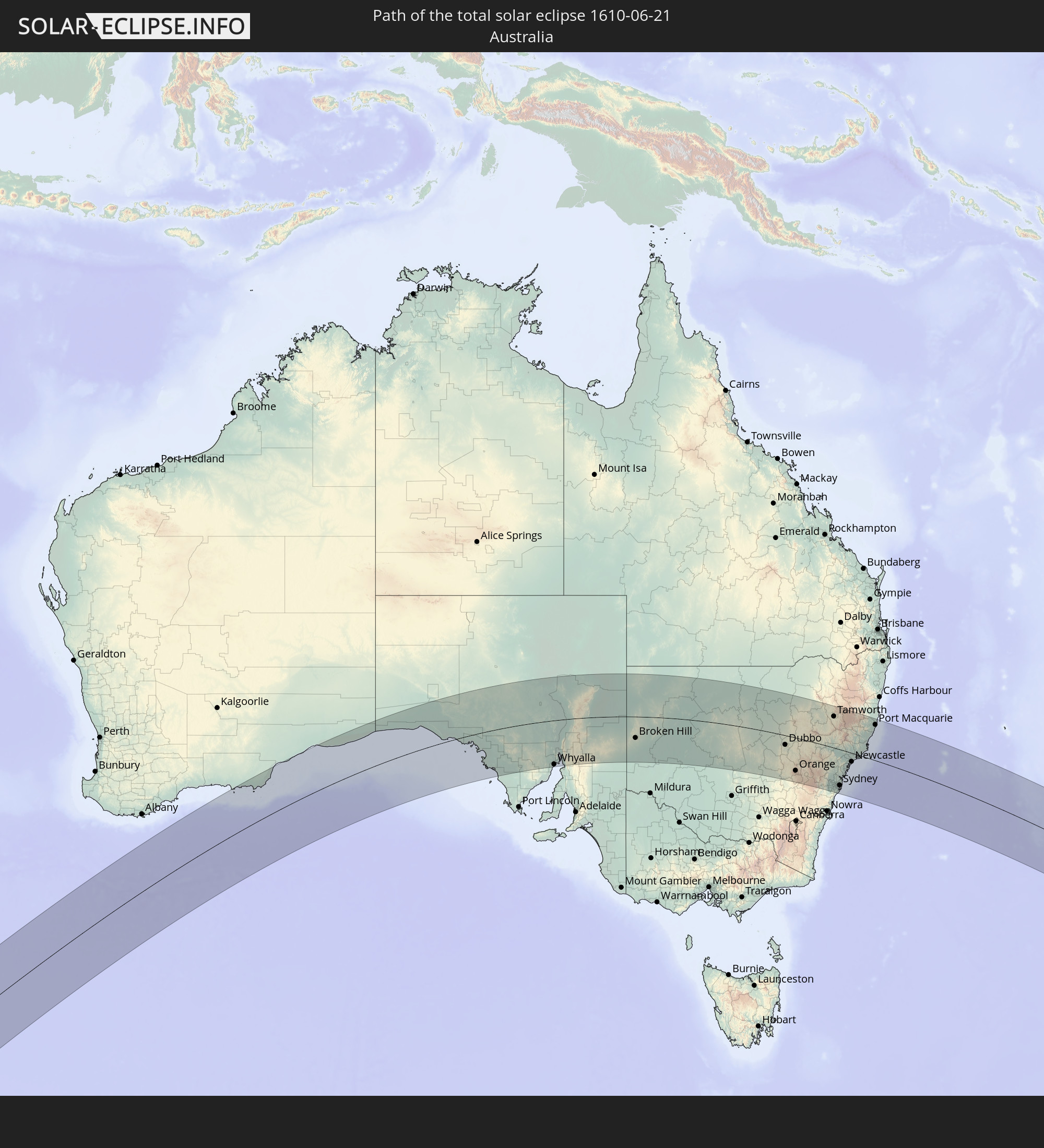 Australia
In den folgenden Ländern ist die Sonnenfinsternis partiell zu sehen


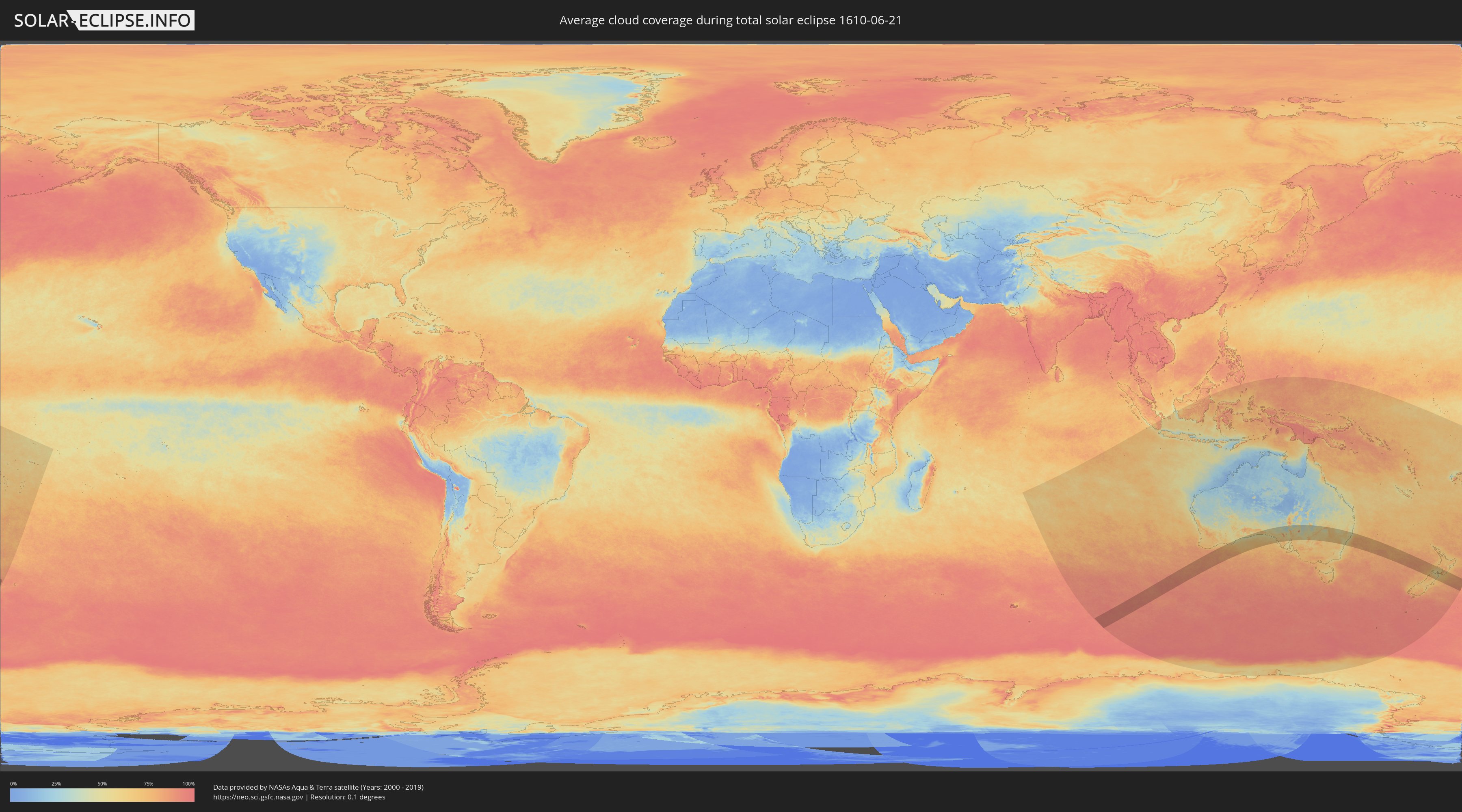
How will be the weather during the total solar eclipse on 06/21/1610?
Where is the best place to see the total solar eclipse of 06/21/1610?
The following maps show the average cloud coverage for the day of the total solar eclipse.
With the help of these maps, it is possible to find the place along the eclipse path, which has the best
chance of a cloudless sky.
Nevertheless, you should consider local circumstances and inform about the weather of your chosen
observation site.
The data is provided by NASAs satellites
AQUA and TERRA.
The cloud maps are averaged over a period of 19 years (2000 - 2019).

Detailed country maps
 New Zealand
 Australia
Cities inside the path of the eclipse
The following table shows all locations with a population of more than 5,000 inside the eclipse path. Cities which have more than 100,000 inhabitants are marked bold. A click at the locations opens a detailed map.
| City | Type | Eclipse duration | Local time of max. eclipse | Distance to central line | Ø Cloud coverage |
 Whyalla, South Australia
|
total | - | 12:55:38 UTC+09:30 | 197 km | 55% |
|
Port Augusta, South Australia
|
total | - | 12:56:23 UTC+09:30 | 140 km | 62% |
|
Broken Hill, New South Wales
|
total | - | 13:05:26 UTC+09:30 | 96 km | 55% |
|
Parkes, New South Wales
|
total | - | 13:49:46 UTC+10:00 | 147 km | 66% |
|
Dubbo, New South Wales
|
total | - | 13:51:20 UTC+10:00 | 41 km | 66% |
|
Orange, New South Wales
|
total | - | 13:51:35 UTC+10:00 | 143 km | 69% |
|
Bathurst, New South Wales
|
total | - | 13:52:29 UTC+10:00 | 146 km | 75% |
|
Mudgee, New South Wales
|
total | - | 13:53:07 UTC+10:00 | 57 km | 65% |
|
Kelso, New South Wales
|
total | - | 13:52:31 UTC+10:00 | 146 km | 75% |
|
Lithgow, New South Wales
|
total | - | 13:53:33 UTC+10:00 | 140 km | 68% |
|
Gunnedah, New South Wales
|
total | - | 13:55:42 UTC+10:00 | 132 km | 55% |
|
Katoomba, New South Wales
|
total | - | 13:53:43 UTC+10:00 | 161 km | 59% |
|
Blaxland, New South Wales
|
total | - | 13:54:16 UTC+10:00 | 157 km | 53% |
|
Glenmore Park, New South Wales
|
total | - | 13:54:22 UTC+10:00 | 159 km | 60% |
|
Cambridge Park, New South Wales
|
total | - | 13:54:31 UTC+10:00 | 153 km | 58% |
|
Narellan, New South Wales
|
total | - | 13:54:18 UTC+10:00 | 183 km | 61% |
|
Narellan Vale, New South Wales
|
total | - | 13:54:19 UTC+10:00 | 185 km | 61% |
|
South Windsor, New South Wales
|
total | - | 13:54:47 UTC+10:00 | 137 km | 59% |
|
Campbelltown, New South Wales
|
total | - | 13:54:27 UTC+10:00 | 185 km | 58% |
|
Leumeah, New South Wales
|
total | - | 13:54:29 UTC+10:00 | 183 km | 58% |
|
Riverstone, New South Wales
|
total | - | 13:54:51 UTC+10:00 | 143 km | 60% |
|
Ingleburn, New South Wales
|
total | - | 13:54:36 UTC+10:00 | 176 km | 53% |
|
Muswellbrook, New South Wales
|
total | - | 13:56:01 UTC+10:00 | 10 km | 59% |
|
Glenfield, New South Wales
|
total | - | 13:54:41 UTC+10:00 | 172 km | 53% |
|
Cabramatta West, New South Wales
|
total | - | 13:54:46 UTC+10:00 | 164 km | 57% |
|
Rouse Hill, New South Wales
|
total | - | 13:54:57 UTC+10:00 | 141 km | 60% |
|
Blacktown, New South Wales
|
total | - | 13:54:53 UTC+10:00 | 150 km | 60% |
|
South Tamworth, New South Wales
|
total | - | 13:56:58 UTC+10:00 | 134 km | 61% |
|
Stanhope Gardens, New South Wales
|
total | - | 13:54:56 UTC+10:00 | 145 km | 60% |
|
Tamworth, New South Wales
|
total | - | 13:56:59 UTC+10:00 | 137 km | 61% |
|
Fairfield Heights, New South Wales
|
total | - | 13:54:51 UTC+10:00 | 160 km | 57% |
|
Chipping Norton, New South Wales
|
total | - | 13:54:50 UTC+10:00 | 164 km | 55% |
|
Northmead, New South Wales
|
total | - | 13:55:00 UTC+10:00 | 150 km | 57% |
|
Heathcote, New South Wales
|
total | - | 13:54:49 UTC+10:00 | 181 km | 48% |
|
Bankstown, New South Wales
|
total | - | 13:55:00 UTC+10:00 | 163 km | 55% |
|
Berala, New South Wales
|
total | - | 13:55:02 UTC+10:00 | 158 km | 55% |
|
Ermington, New South Wales
|
total | - | 13:55:07 UTC+10:00 | 152 km | 57% |
|
Beecroft, New South Wales
|
total | - | 13:55:11 UTC+10:00 | 144 km | 58% |
|
Kirrawee, New South Wales
|
total | - | 13:54:58 UTC+10:00 | 175 km | 53% |
|
Oatley, New South Wales
|
total | - | 13:55:01 UTC+10:00 | 169 km | 53% |
|
Pennant Hills, New South Wales
|
total | - | 13:55:13 UTC+10:00 | 143 km | 58% |
|
Belfield, New South Wales
|
total | - | 13:55:06 UTC+10:00 | 160 km | 55% |
|
Gymea, New South Wales
|
total | - | 13:55:00 UTC+10:00 | 174 km | 53% |
|
Gymea Bay, New South Wales
|
total | - | 13:54:59 UTC+10:00 | 176 km | 50% |
|
Hornsby Heights, New South Wales
|
total | - | 13:55:19 UTC+10:00 | 135 km | 58% |
|
Hornsby, New South Wales
|
total | - | 13:55:18 UTC+10:00 | 139 km | 58% |
|
Macquarie Park, New South Wales
|
total | - | 13:55:16 UTC+10:00 | 146 km | 57% |
|
Mount Colah, New South Wales
|
total | - | 13:55:21 UTC+10:00 | 136 km | 58% |
|
Caringbah, New South Wales
|
total | - | 13:55:03 UTC+10:00 | 175 km | 53% |
|
Summer Hill, New South Wales
|
total | - | 13:55:13 UTC+10:00 | 158 km | 55% |
|
Pymble, New South Wales
|
total | - | 13:55:21 UTC+10:00 | 142 km | 58% |
|
Hunters Hill, New South Wales
|
total | - | 13:55:17 UTC+10:00 | 151 km | 57% |
|
Arncliffe, New South Wales
|
total | - | 13:55:12 UTC+10:00 | 162 km | 55% |
|
Brighton-Le-Sands, New South Wales
|
total | - | 13:55:11 UTC+10:00 | 165 km | 55% |
|
Killara, New South Wales
|
total | - | 13:55:22 UTC+10:00 | 144 km | 56% |
|
Lilyfield, New South Wales
|
total | - | 13:55:17 UTC+10:00 | 155 km | 57% |
|
Singleton, New South Wales
|
total | - | 13:56:20 UTC+10:00 | 16 km | 59% |
|
Lane Cove North, New South Wales
|
total | - | 13:55:21 UTC+10:00 | 148 km | 56% |
|
Lindfield, New South Wales
|
total | - | 13:55:22 UTC+10:00 | 145 km | 56% |
|
Camperdown, New South Wales
|
total | - | 13:55:18 UTC+10:00 | 156 km | 57% |
|
Chatswood, New South Wales
|
total | - | 13:55:23 UTC+10:00 | 147 km | 56% |
|
Artarmon, New South Wales
|
total | - | 13:55:22 UTC+10:00 | 148 km | 56% |
|
Wollstonecraft, New South Wales
|
total | - | 13:55:22 UTC+10:00 | 150 km | 56% |
|
Mascot, New South Wales
|
total | - | 13:55:18 UTC+10:00 | 160 km | 57% |
|
Botany, New South Wales
|
total | - | 13:55:17 UTC+10:00 | 162 km | 57% |
|
Haberfield, New South Wales
|
total | - | 13:55:21 UTC+10:00 | 155 km | 57% |
|
Alexandria, New South Wales
|
total | - | 13:55:20 UTC+10:00 | 157 km | 57% |
|
North Sydney, New South Wales
|
total | - | 13:55:24 UTC+10:00 | 150 km | 56% |
|
Sydney, New South Wales
|
total | - | 13:55:22 UTC+10:00 | 153 km | 57% |
|
Forestville, New South Wales
|
total | - | 13:55:27 UTC+10:00 | 142 km | 56% |
|
Cammeray, New South Wales
|
total | - | 13:55:26 UTC+10:00 | 148 km | 56% |
|
Matraville, New South Wales
|
total | - | 13:55:21 UTC+10:00 | 161 km | 55% |
|
Woollahra, New South Wales
|
total | - | 13:55:25 UTC+10:00 | 155 km | 57% |
|
Bondi Junction, New South Wales
|
total | - | 13:55:26 UTC+10:00 | 155 km | 57% |
|
Allambie Heights, New South Wales
|
total | - | 13:55:32 UTC+10:00 | 141 km | 56% |
|
Bellevue Hill, New South Wales
|
total | - | 13:55:27 UTC+10:00 | 153 km | 54% |
|
Balgowlah, New South Wales
|
total | - | 13:55:32 UTC+10:00 | 144 km | 54% |
|
Bronte, New South Wales
|
total | - | 13:55:28 UTC+10:00 | 155 km | 54% |
|
North Bondi, New South Wales
|
total | - | 13:55:29 UTC+10:00 | 153 km | 54% |
|
Freshwater, New South Wales
|
total | - | 13:55:36 UTC+10:00 | 142 km | 54% |
|
Narrabeen, New South Wales
|
total | - | 13:55:40 UTC+10:00 | 134 km | 55% |
|
Dee Why, New South Wales
|
total | - | 13:55:39 UTC+10:00 | 138 km | 54% |
|
Umina, New South Wales
|
total | - | 13:55:51 UTC+10:00 | 114 km | 52% |
|
Newport, New South Wales
|
total | - | 13:55:46 UTC+10:00 | 127 km | 55% |
|
Narara, New South Wales
|
total | - | 13:56:02 UTC+10:00 | 100 km | 51% |
|
Cessnock, New South Wales
|
total | - | 13:56:30 UTC+10:00 | 39 km | 57% |
|
Berkeley Vale, New South Wales
|
total | - | 13:56:14 UTC+10:00 | 92 km | 51% |
|
Bateau Bay, New South Wales
|
total | - | 13:56:16 UTC+10:00 | 95 km | 51% |
|
Gorokan, New South Wales
|
total | - | 13:56:27 UTC+10:00 | 80 km | 52% |
|
Maitland, New South Wales
|
total | - | 13:56:58 UTC+10:00 | 23 km | 58% |
|
Rathmines, New South Wales
|
total | - | 13:56:47 UTC+10:00 | 55 km | 51% |
|
Eleebana, New South Wales
|
total | - | 13:56:55 UTC+10:00 | 48 km | 51% |
|
Belmont North, New South Wales
|
total | - | 13:56:57 UTC+10:00 | 50 km | 51% |
|
Raymond Terrace, New South Wales
|
total | - | 13:57:20 UTC+10:00 | 19 km | 54% |
|
Newcastle, New South Wales
|
total | - | 13:57:14 UTC+10:00 | 38 km | 54% |
|
Port Stephens, New South Wales
|
total | - | 13:57:59 UTC+10:00 | 7 km | 51% |
|
Nelson Bay, New South Wales
|
total | - | 13:58:07 UTC+10:00 | 5 km | 51% |
|
Taree, New South Wales
|
total | - | 13:59:22 UTC+10:00 | 89 km | 49% |
|
Forster, New South Wales
|
total | - | 13:59:16 UTC+10:00 | 62 km | 51% |
|
Port Macquarie, New South Wales
|
total | - | 14:00:37 UTC+10:00 | 153 km | 47% |
 Port Motueka, Tasman
|
total | - | 15:48:23 UTC+11:30 | 32 km | 56% |
|
Richmond, Tasman
|
total | - | 15:48:17 UTC+11:30 | 44 km | 56% |
|
Nelson, Nelson
|
total | - | 15:48:27 UTC+11:30 | 33 km | 57% |
|
Blenheim, Marlborough
|
total | - | 15:48:44 UTC+11:30 | 27 km | 54% |
|
Wellington, Wellington
|
total | - | 15:49:42 UTC+11:30 | 31 km | 69% |
|
Porirua, Wellington
|
total | - | 15:49:57 UTC+11:30 | 49 km | 72% |
|
Petone, Wellington
|
total | - | 15:49:51 UTC+11:30 | 41 km | 74% |
|
Lower Hutt, Wellington
|
total | - | 15:49:54 UTC+11:30 | 44 km | 74% |
|
Paraparaumu, Wellington
|
total | - | 15:50:21 UTC+11:30 | 77 km | 76% |
|
Upper Hutt, Wellington
|
total | - | 15:50:07 UTC+11:30 | 57 km | 78% |
|
Otaki, Wellington
|
total | - | 15:50:39 UTC+11:30 | 98 km | 80% |
|
Levin, Manawatu-Wanganui
|
total | - | 15:50:54 UTC+11:30 | 115 km | 77% |
|
Masterton, Wellington
|
total | - | 15:50:49 UTC+11:30 | 101 km | 69% |