Total solar eclipse of 04/10/1679
| Day of week: | Monday |
| Maximum duration of eclipse: | 04m17s |
| Maximum width of eclipse path: | 233 km |
| Saros cycle: | 114 |
| Coverage: | 100% |
| Magnitude: | 1.0565 |
| Gamma: | 0.607 |
Wo kann man die Sonnenfinsternis vom 04/10/1679 sehen?
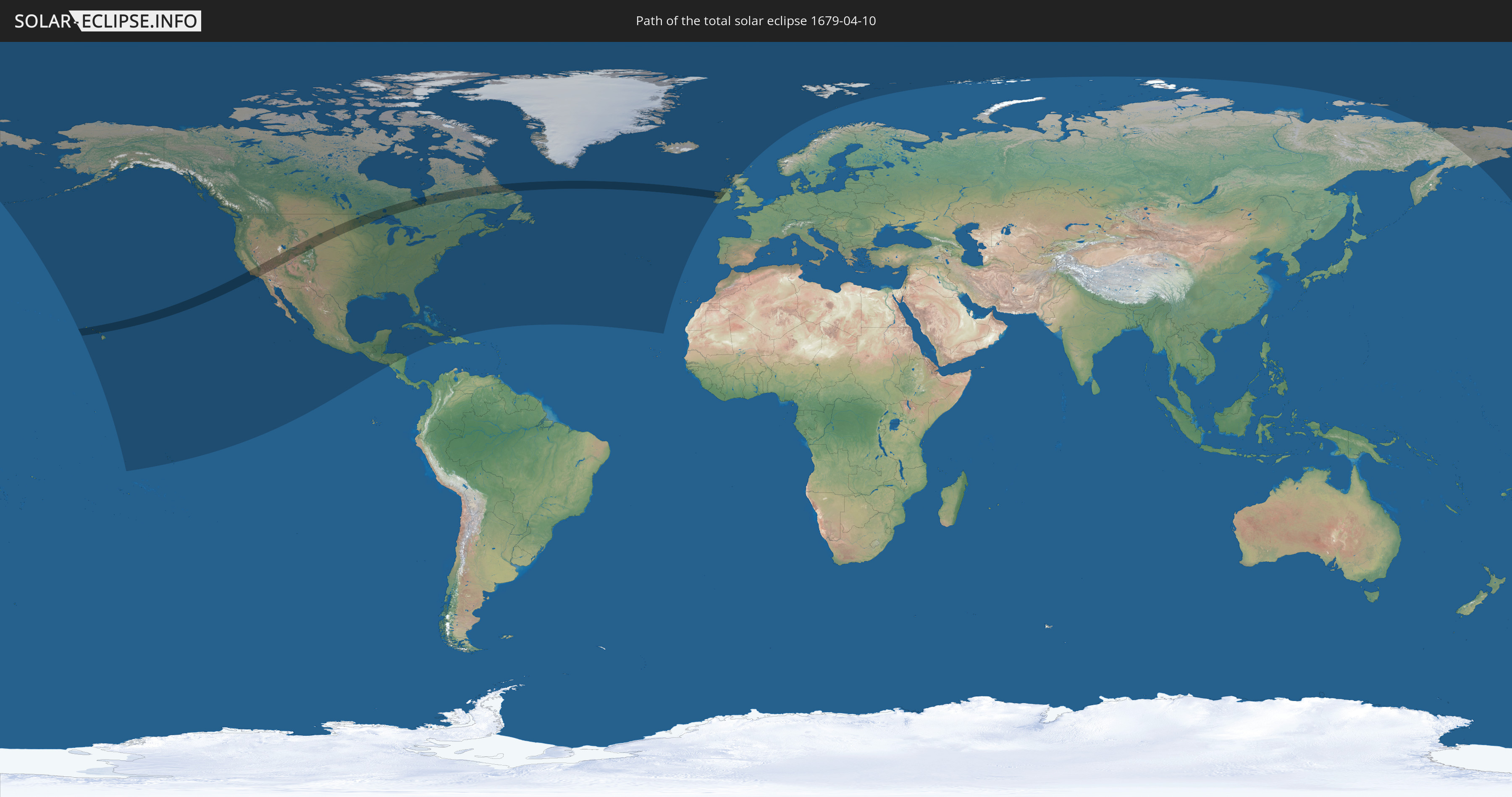
Die Sonnenfinsternis am 04/10/1679 kann man in 27 Ländern als partielle Sonnenfinsternis beobachten.
Der Finsternispfad verläuft durch 3 Länder. Nur in diesen Ländern ist sie als total Sonnenfinsternis zu sehen.
In den folgenden Ländern ist die Sonnenfinsternis total zu sehen
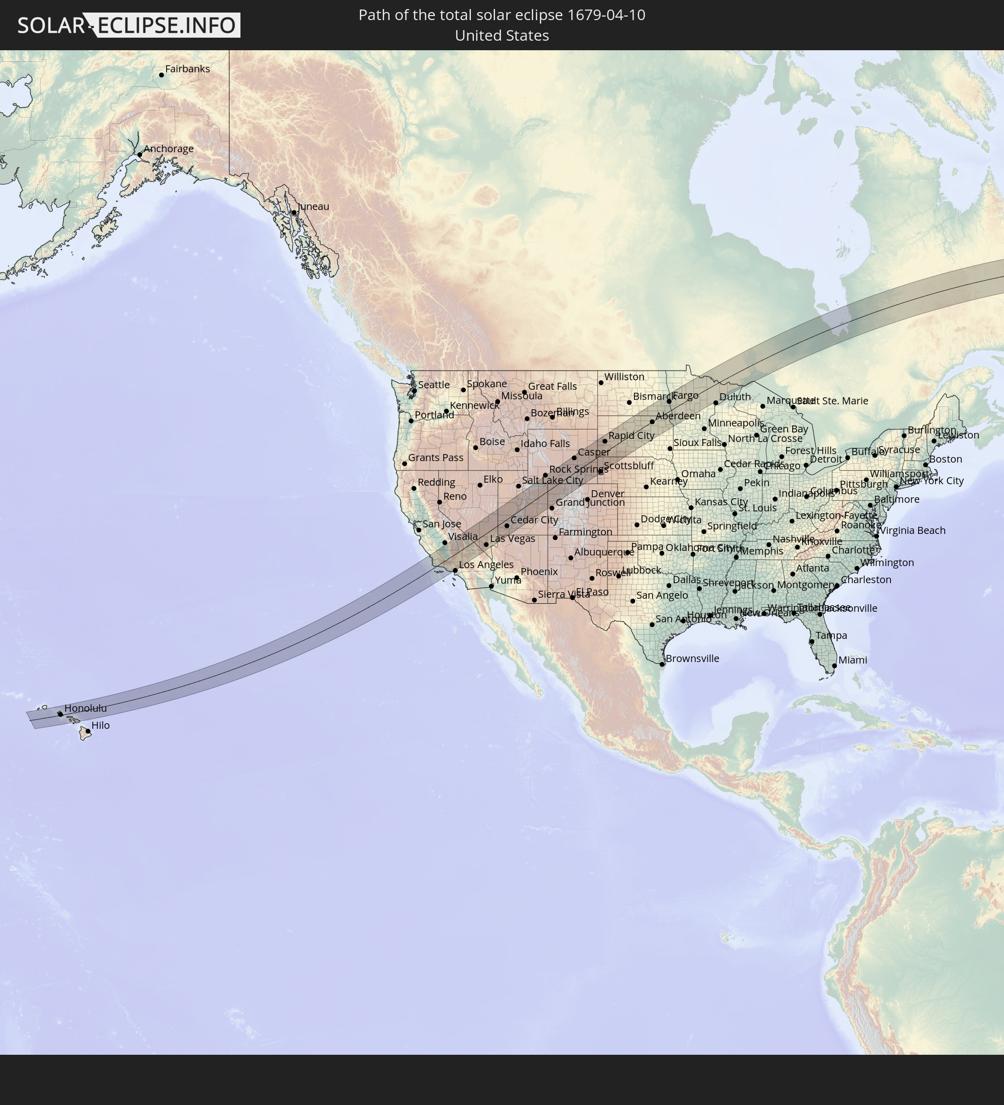 United States
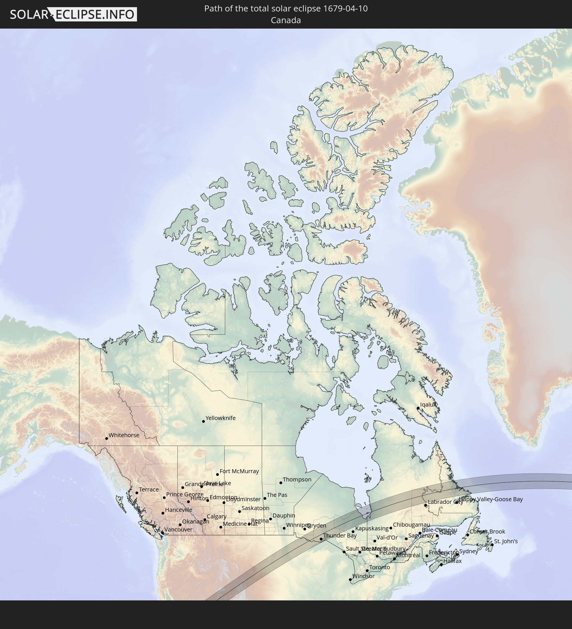 Canada
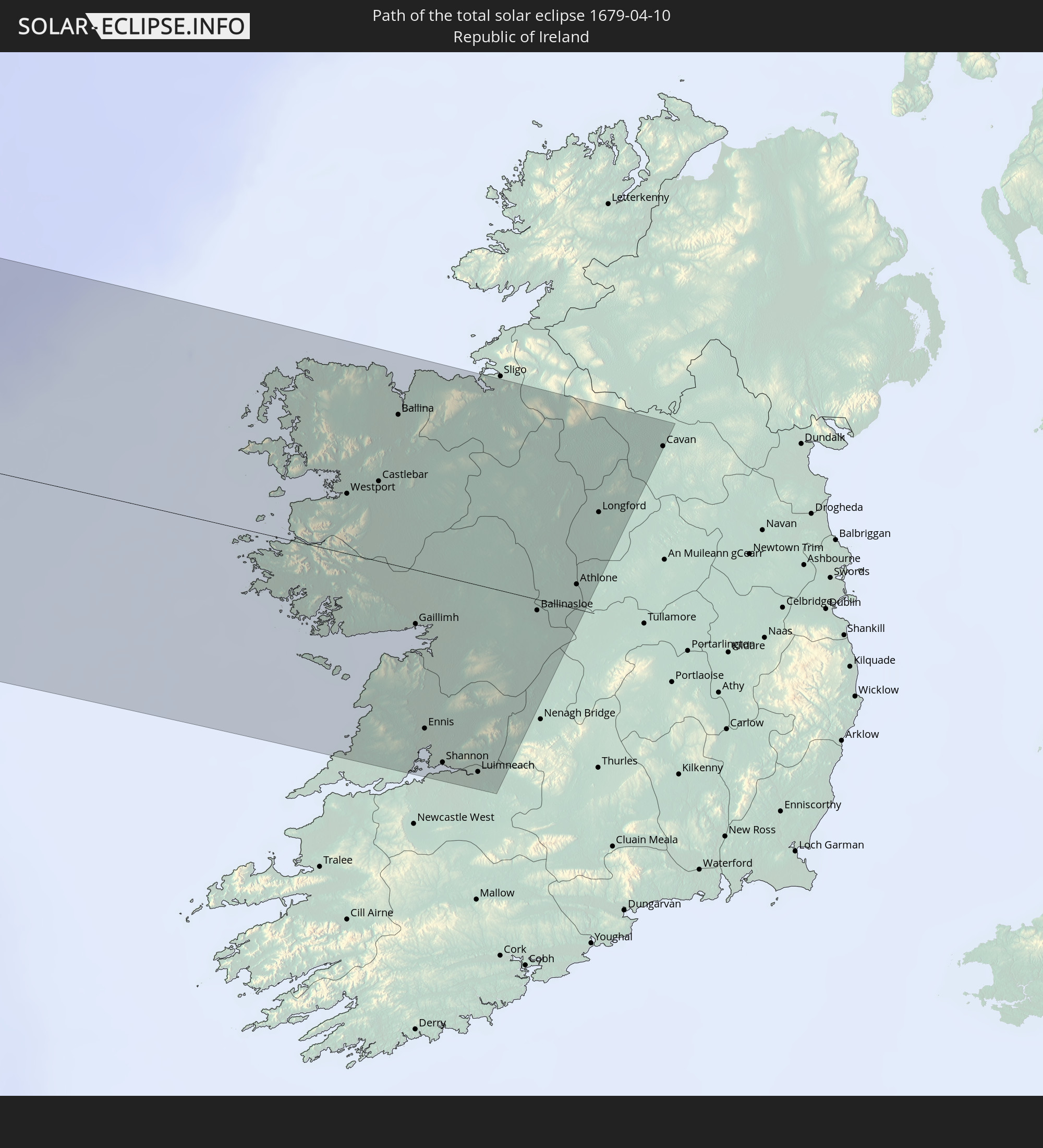 Republic of Ireland
In den folgenden Ländern ist die Sonnenfinsternis partiell zu sehen
 Russia
 United States
 Kiribati
 French Polynesia
 Canada
 Mexico
 Greenland
 Guatemala
 El Salvador
 Honduras
 Belize
 Nicaragua
 Cuba
Cuba
 Cayman Islands
 The Bahamas
 Jamaica
 Haiti
Haiti
 Turks and Caicos Islands
 Dominican Republic
 Bermuda
 Saint Pierre and Miquelon
 Portugal
 Iceland
 Republic of Ireland
 Svalbard and Jan Mayen
 United Kingdom
 Faroe Islands
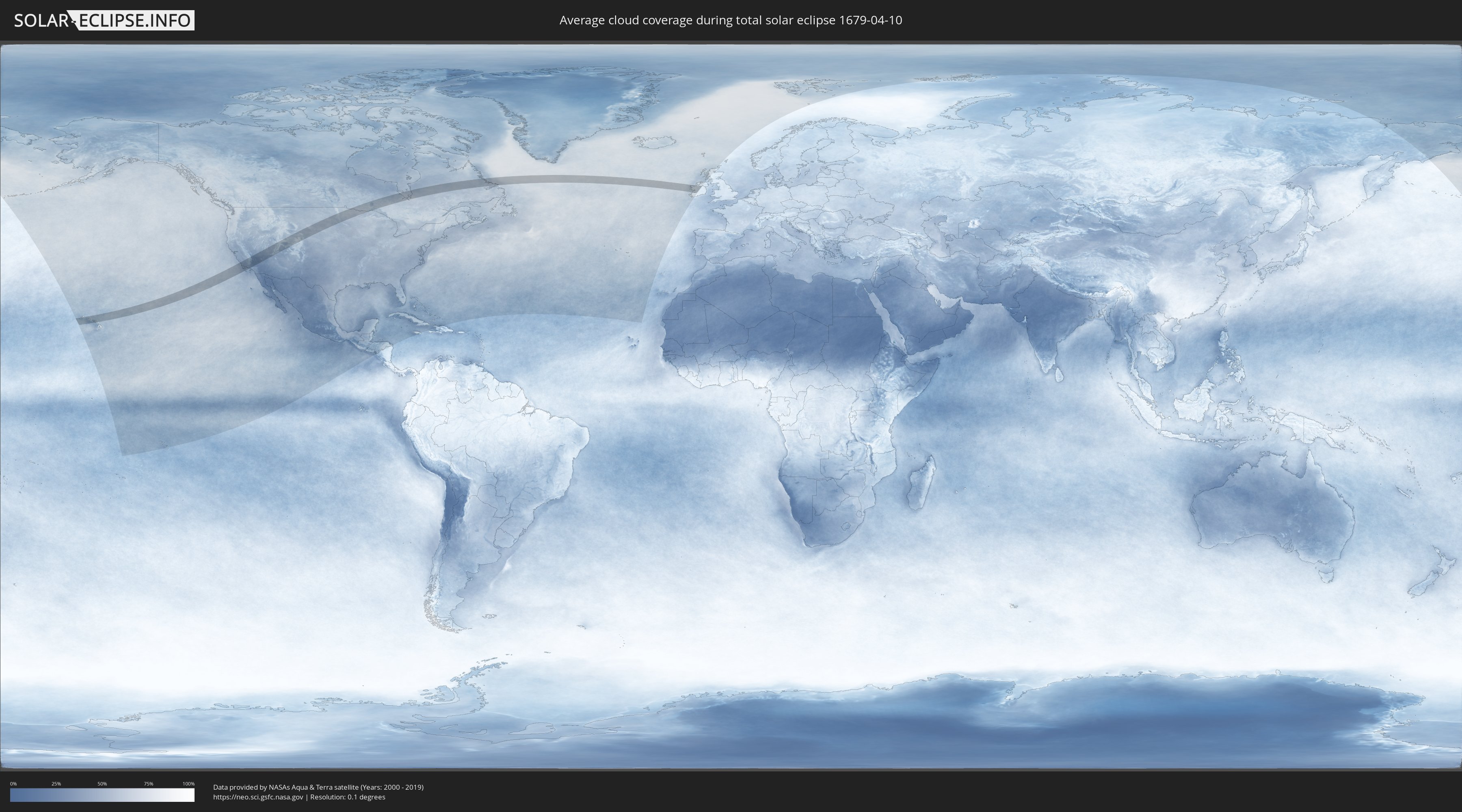
How will be the weather during the total solar eclipse on 04/10/1679?
Where is the best place to see the total solar eclipse of 04/10/1679?
The following maps show the average cloud coverage for the day of the total solar eclipse.
With the help of these maps, it is possible to find the place along the eclipse path, which has the best
chance of a cloudless sky.
Nevertheless, you should consider local circumstances and inform about the weather of your chosen
observation site.
The data is provided by NASAs satellites
AQUA and TERRA.
The cloud maps are averaged over a period of 19 years (2000 - 2019).

Detailed country maps
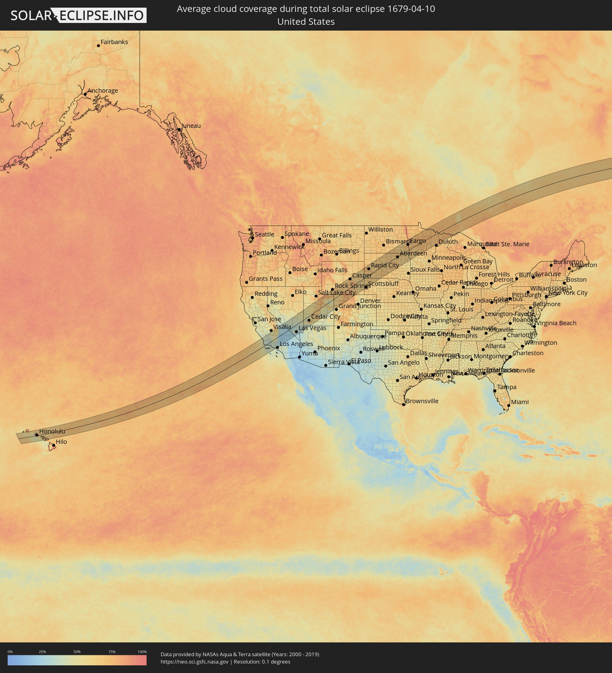 United States
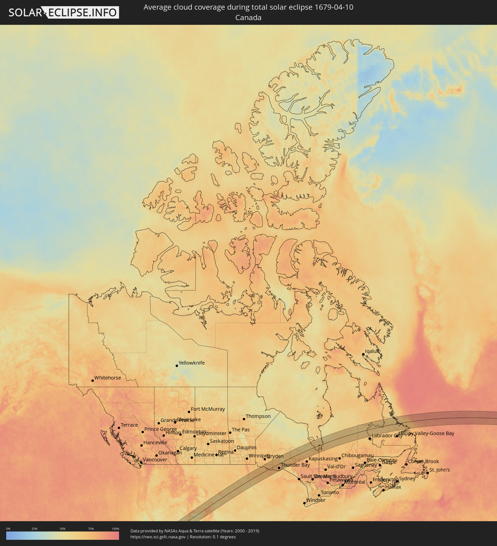 Canada
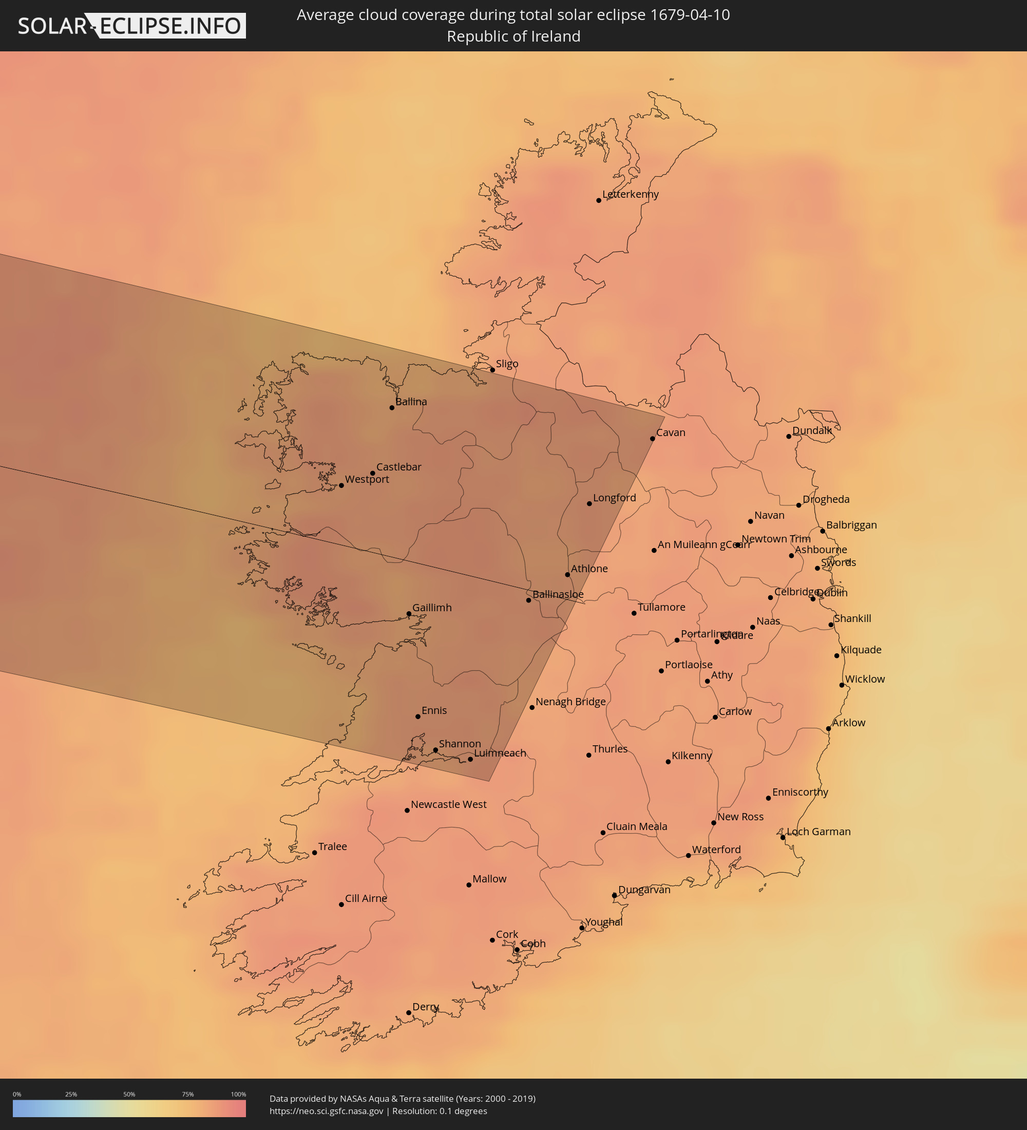 Republic of Ireland
Cities inside the path of the eclipse
The following table shows all locations with a population of more than 5,000 inside the eclipse path. Cities which have more than 100,000 inhabitants are marked bold. A click at the locations opens a detailed map.
| City | Type | Eclipse duration | Local time of max. eclipse | Distance to central line | Ø Cloud coverage |
|
Waianae, Hawaii
|
total | - | 06:03:05 UTC-10:30 | 21 km | 68% |
|
Mā‘ili, Hawaii
|
total | - | 06:03:03 UTC-10:30 | 19 km | 68% |
|
Pearl City, Hawaii
|
total | - | 06:03:01 UTC-10:30 | 13 km | 69% |
|
‘Aiea, Hawaii
|
total | - | 06:03:00 UTC-10:30 | 11 km | 72% |
|
Honolulu, Hawaii
|
total | - | 06:02:54 UTC-10:30 | 1 km | 66% |
|
Marine Corps Base Hawaii - MCBH, Hawaii
|
total | - | 06:03:03 UTC-10:30 | 14 km | 77% |
|
Kailua, Hawaii
|
total | - | 06:03:00 UTC-10:30 | 9 km | 77% |
|
Lahaina, Hawaii
|
total | - | 06:02:20 UTC-10:30 | 69 km | 55% |
|
Kahului, Hawaii
|
total | - | 06:02:20 UTC-10:30 | 71 km | 76% |
|
Morro Bay, California
|
total | - | 09:14:40 UTC-08:00 | 119 km | 40% |
|
Los Osos, California
|
total | - | 09:14:36 UTC-08:00 | 113 km | 40% |
|
San Luis Obispo, California
|
total | - | 09:14:46 UTC-08:00 | 102 km | 37% |
|
Arroyo Grande, California
|
total | - | 09:14:34 UTC-08:00 | 84 km | 40% |
|
Lompoc, California
|
total | - | 09:13:55 UTC-08:00 | 32 km | 40% |
|
Santa Maria, California
|
total | - | 09:14:28 UTC-08:00 | 60 km | 40% |
|
Santa Barbara, California
|
total | - | 09:14:30 UTC-08:00 | 26 km | 40% |
|
Carpinteria, California
|
total | - | 09:14:41 UTC-08:00 | 37 km | 38% |
|
Taft, California
|
total | - | 09:16:02 UTC-08:00 | 30 km | 38% |
|
Wasco, California
|
total | - | 09:16:57 UTC-08:00 | 66 km | 42% |
|
Delano, California
|
total | - | 09:17:22 UTC-08:00 | 78 km | 44% |
|
Oxnard, California
|
total | - | 09:14:47 UTC-08:00 | 73 km | 35% |
|
Lindsay, California
|
total | - | 09:18:19 UTC-08:00 | 110 km | 48% |
|
Santa Paula, California
|
total | - | 09:15:12 UTC-08:00 | 64 km | 37% |
|
Bakersfield, California
|
total | - | 09:16:59 UTC-08:00 | 29 km | 47% |
|
Porterville, California
|
total | - | 09:18:10 UTC-08:00 | 94 km | 48% |
|
Thousand Oaks, California
|
total | - | 09:15:10 UTC-08:00 | 92 km | 35% |
|
Arvin, California
|
total | - | 09:16:57 UTC-08:00 | 5 km | 48% |
|
Malibu Beach, California
|
total | - | 09:15:08 UTC-08:00 | 112 km | 40% |
|
West Hills, California
|
total | - | 09:15:28 UTC-08:00 | 99 km | 36% |
|
Santa Clarita, California
|
total | - | 09:15:56 UTC-08:00 | 86 km | 36% |
|
Tehachapi, California
|
total | - | 09:17:19 UTC-08:00 | 21 km | 39% |
|
Van Nuys, California
|
total | - | 09:15:43 UTC-08:00 | 110 km | 34% |
|
La Crescenta-Montrose, California
|
total | - | 09:16:04 UTC-08:00 | 116 km | 38% |
|
Rosamond, California
|
total | - | 09:17:14 UTC-08:00 | 61 km | 27% |
|
Lancaster, California
|
total | - | 09:17:00 UTC-08:00 | 77 km | 28% |
|
Vincent, California
|
total | - | 09:16:41 UTC-08:00 | 97 km | 29% |
|
California City, California
|
total | - | 09:17:55 UTC-08:00 | 45 km | 26% |
|
Lake Los Angeles, California
|
total | - | 09:17:15 UTC-08:00 | 101 km | 25% |
|
Ridgecrest, California
|
total | - | 09:19:11 UTC-08:00 | 14 km | 22% |
|
Barstow Heights, California
|
total | - | 09:18:44 UTC-08:00 | 115 km | 24% |
|
Pahrump, Nevada
|
total | - | 09:22:28 UTC-08:00 | 44 km | 29% |
|
Enterprise, Nevada
|
total | - | 09:23:12 UTC-08:00 | 98 km | 29% |
|
Las Vegas, Nevada
|
total | - | 09:23:36 UTC-08:00 | 89 km | 32% |
|
Henderson, Nevada
|
total | - | 09:23:36 UTC-08:00 | 110 km | 28% |
|
Mesquite, Nevada
|
total | - | 09:26:11 UTC-08:00 | 84 km | 34% |
|
Saint George, Utah
|
total | - | 10:27:23 UTC-07:00 | 81 km | 38% |
|
Hurricane, Utah
|
total | - | 10:27:56 UTC-07:00 | 89 km | 36% |
|
Cedar City, Utah
|
total | - | 10:29:05 UTC-07:00 | 54 km | 53% |
|
Santaquin, Utah
|
total | - | 10:34:40 UTC-07:00 | 94 km | 67% |
|
Payson, Utah
|
total | - | 10:34:51 UTC-07:00 | 98 km | 74% |
|
Provo, Utah
|
total | - | 10:35:15 UTC-07:00 | 111 km | 61% |
|
Rock Springs, Wyoming
|
total | - | 10:41:00 UTC-07:00 | 116 km | 67% |
|
Craig, Colorado
|
total | - | 10:41:58 UTC-07:00 | 61 km | 68% |
|
Rawlins, Wyoming
|
total | - | 10:44:19 UTC-07:00 | 41 km | 62% |
|
Steamboat Springs, Colorado
|
total | - | 10:43:03 UTC-07:00 | 98 km | 78% |
|
Casper, Wyoming
|
total | - | 10:47:17 UTC-07:00 | 97 km | 61% |
|
Laramie, Wyoming
|
total | - | 10:46:14 UTC-07:00 | 80 km | 60% |
|
Rapid City, South Dakota
|
total | - | 10:53:43 UTC-07:00 | 68 km | 71% |
|
Pierre, South Dakota
|
total | - | 11:58:41 UTC-06:00 | 31 km | 61% |
|
Aberdeen, South Dakota
|
total | - | 12:02:55 UTC-06:00 | 6 km | 67% |
|
Fargo, North Dakota
|
total | - | 12:07:03 UTC-06:00 | 59 km | 70% |
|
Fergus Falls, Minnesota
|
total | - | 12:07:37 UTC-06:00 | 26 km | 65% |
|
Alexandria, Minnesota
|
total | - | 12:08:22 UTC-06:00 | 91 km | 65% |
|
Bemidji, Minnesota
|
total | - | 12:10:35 UTC-06:00 | 42 km | 75% |
|
Brainerd, Minnesota
|
total | - | 12:10:42 UTC-06:00 | 91 km | 70% |
|
Grand Rapids, Minnesota
|
total | - | 12:12:31 UTC-06:00 | 32 km | 71% |
|
Fort Frances, Ontario
|
total | - | 12:13:47 UTC-06:00 | 95 km | 71% |
|
Hibbing, Minnesota
|
total | - | 12:13:36 UTC-06:00 | 35 km | 69% |
|
Thunder Bay, Ontario
|
total | - | 13:20:02 UTC-05:00 | 72 km | 76% |
|
Westport, Connaught
|
total | - | 18:51:21 UTC-00:25 | 26 km | 83% |
|
Castlebar, Connaught
|
total | - | 18:51:16 UTC-00:25 | 35 km | 84% |
|
Ballina, Connaught
|
total | - | 18:50:57 UTC-00:25 | 66 km | 80% |
|
Gaillimh, Connaught
|
total | - | 18:51:52 UTC-00:25 | 24 km | 80% |
|
Ennis, Munster
|
total | - | 18:52:20 UTC-00:25 | 69 km | 84% |
|
Shannon, Munster
|
total | - | 18:52:28 UTC-00:25 | 82 km | 83% |
|
Tuam, Connaught
|
total | - | 18:51:35 UTC-00:25 | 6 km | 83% |
|
Luimneach, Munster
|
total | - | 18:52:29 UTC-00:25 | 83 km | 85% |
|
Loughrea, Connaught
|
total | - | 18:51:53 UTC-00:25 | 24 km | 84% |
|
Ballinasloe, Connaught
|
total | - | 18:51:41 UTC-00:25 | 5 km | 85% |
|
Roscommon, Connaught
|
total | - | 18:51:21 UTC-00:25 | 29 km | 81% |
|
Athlone, Leinster
|
total | - | 18:51:32 UTC-00:25 | 11 km | 85% |
|
Longford, Leinster
|
total | - | 18:51:11 UTC-00:25 | 45 km | 86% |
|
Cavan, Ulster
|
total | - | 18:50:49 UTC-00:25 | 81 km | 85% |