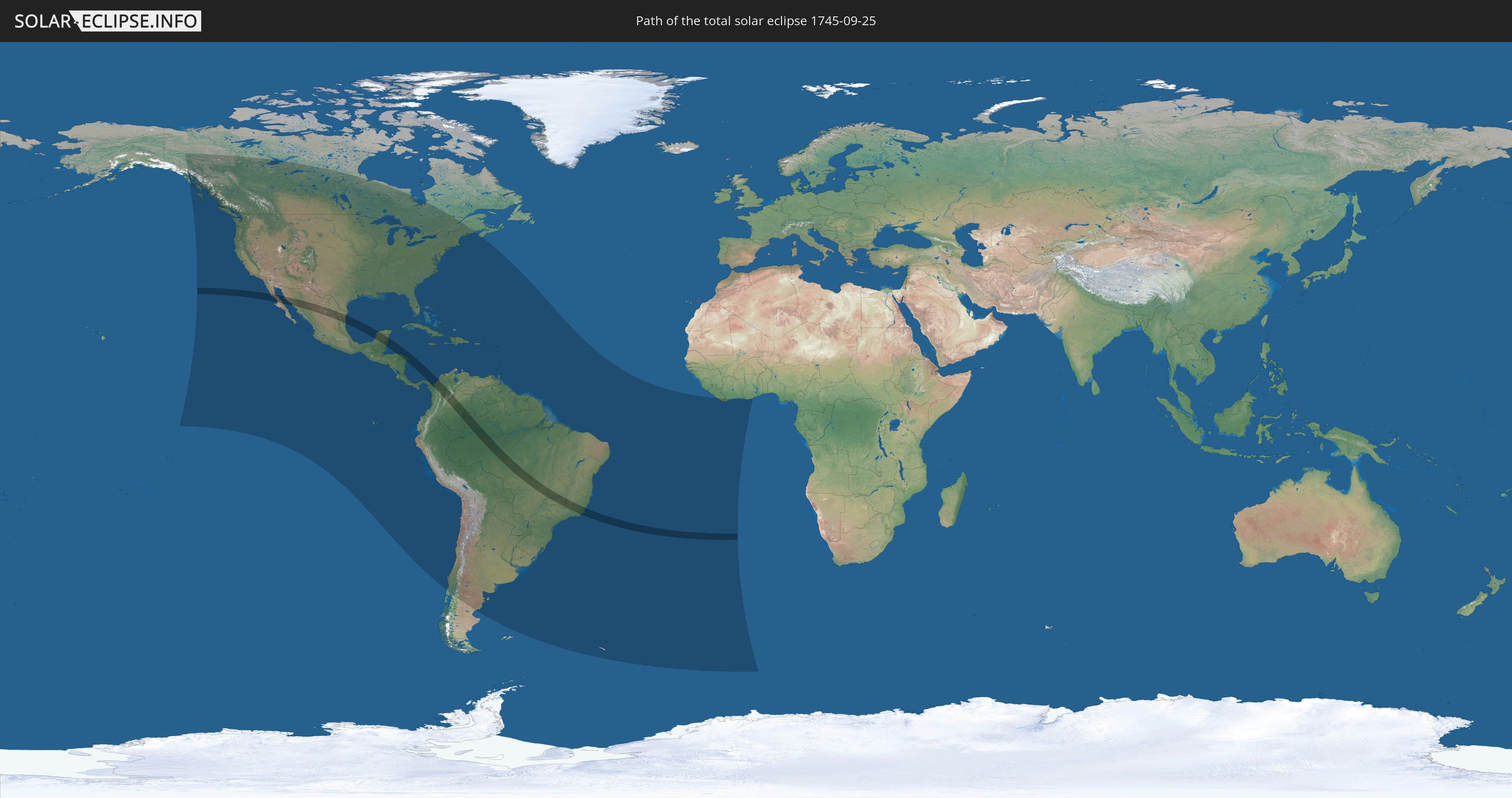
Total solar eclipse of 09/25/1745
| Day of week: | Saturday |
| Maximum duration of eclipse: | 05m21s |
| Maximum width of eclipse path: | 214 km |
| Saros cycle: | 130 |
| Coverage: | 100% |
| Magnitude: | 1.0655 |
| Gamma: | 0.0269 |
Wo kann man die Sonnenfinsternis vom 09/25/1745 sehen?
Die Sonnenfinsternis am 09/25/1745 kann man in 56 Ländern als partielle Sonnenfinsternis beobachten.
Der Finsternispfad verläuft durch 7 Länder. Nur in diesen Ländern ist sie als total Sonnenfinsternis zu sehen.
In den folgenden Ländern ist die Sonnenfinsternis total zu sehen
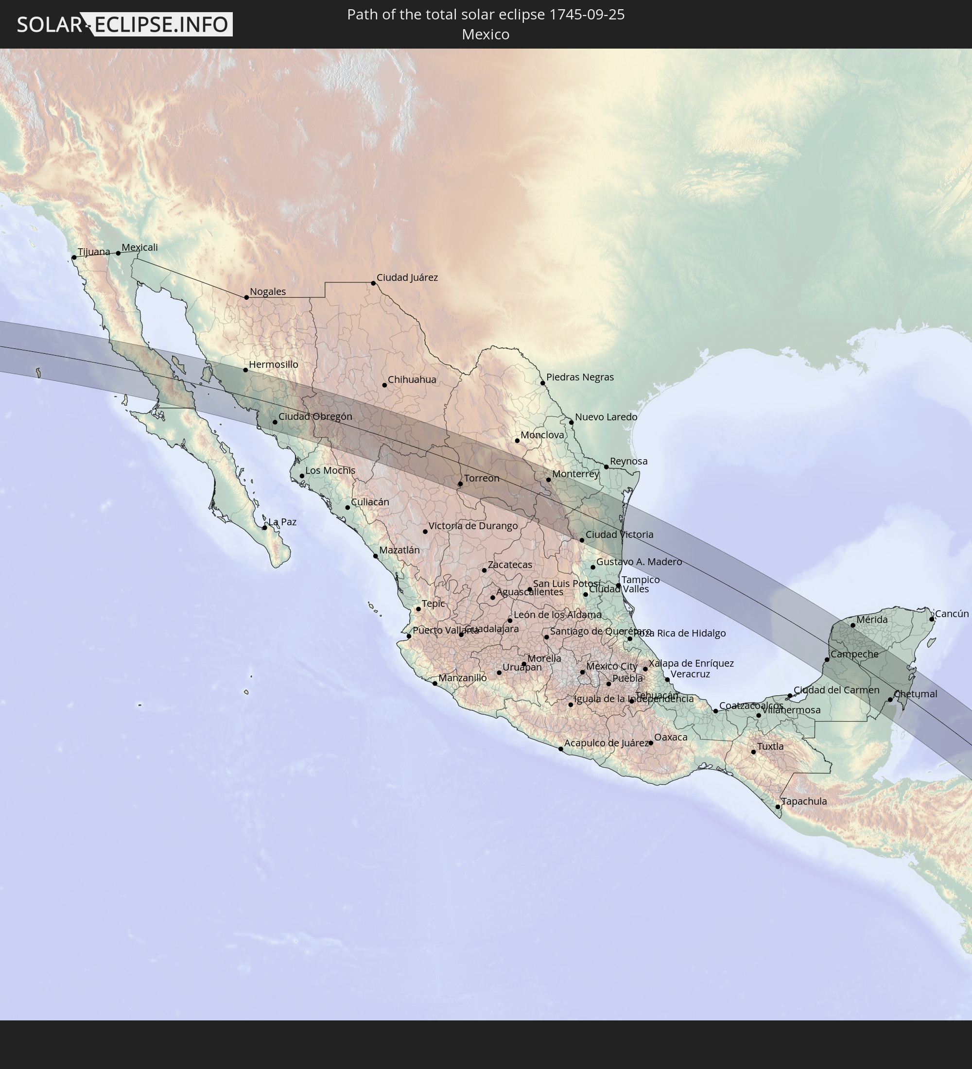 Mexico
 Honduras
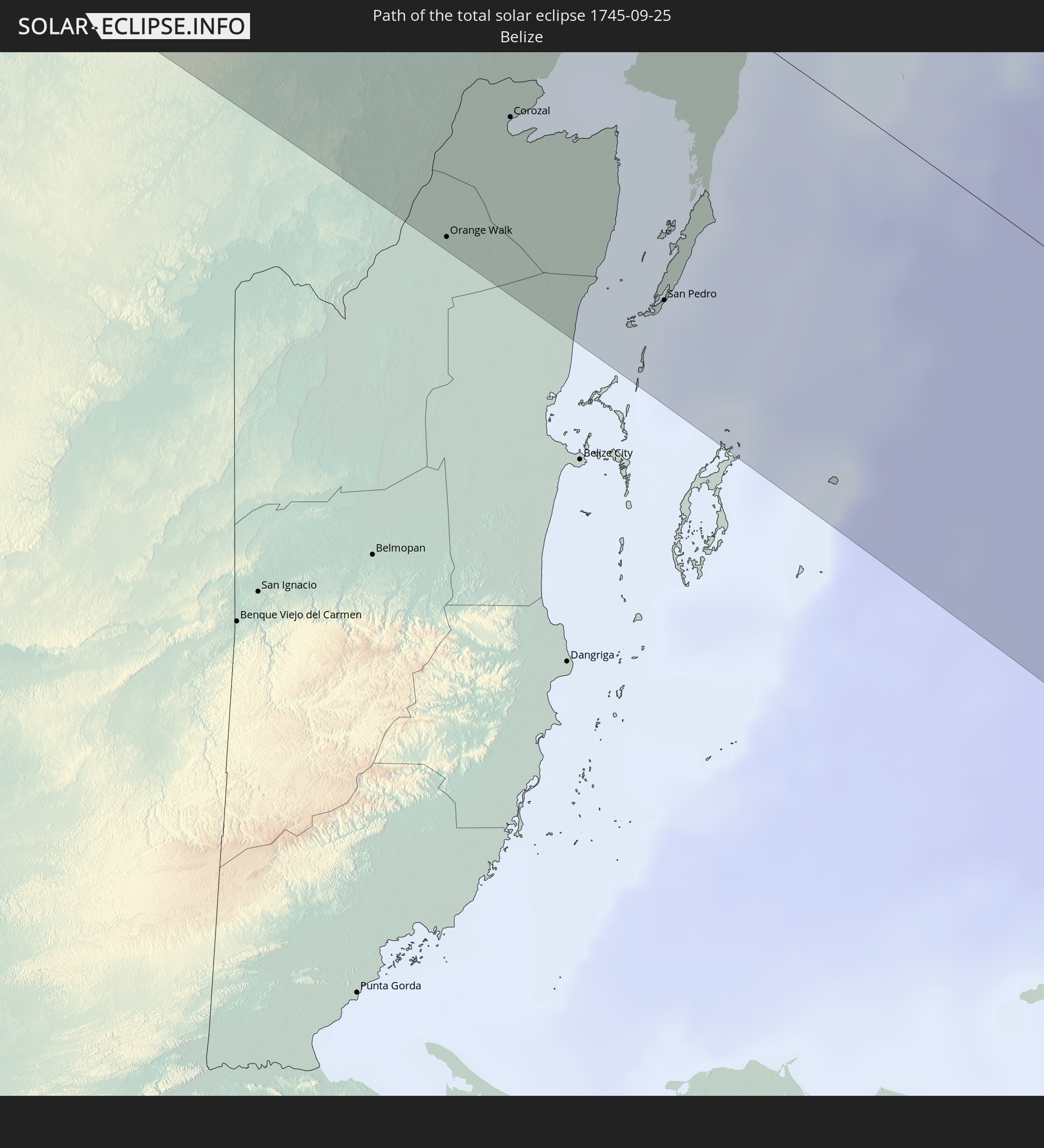 Belize
 Nicaragua
 Panama
 Colombia
 Brazil
In den folgenden Ländern ist die Sonnenfinsternis partiell zu sehen
 United States
 United States Minor Outlying Islands
 Canada
 Mexico
 Chile
Chile
 Greenland
 Guatemala
 Ecuador
 El Salvador
 Honduras
 Belize
 Nicaragua
 Costa Rica
 Cuba
Cuba
 Panama
 Colombia
 Cayman Islands
 Peru
Peru
 The Bahamas
 Jamaica
 Haiti
Haiti
 Brazil
 Argentina
 Venezuela
 Turks and Caicos Islands
 Dominican Republic
 Aruba
Aruba
 Bolivia
 Puerto Rico
 United States Virgin Islands
 Bermuda
 British Virgin Islands
 Anguilla
 Collectivity of Saint Martin
 Saint Barthélemy
 Saint Kitts and Nevis
 Paraguay
 Antigua and Barbuda
 Montserrat
 Trinidad and Tobago
 Guadeloupe
 Grenada
 Dominica
 Saint Vincent and the Grenadines
 Guyana
 Martinique
 Saint Lucia
 Barbados
 Uruguay
 Suriname
 French Guiana
 South Georgia and the South Sandwich Islands
 Saint Helena, Ascension and Tristan da Cunha
 Liberia
 Ivory Coast
 Ghana
Ghana
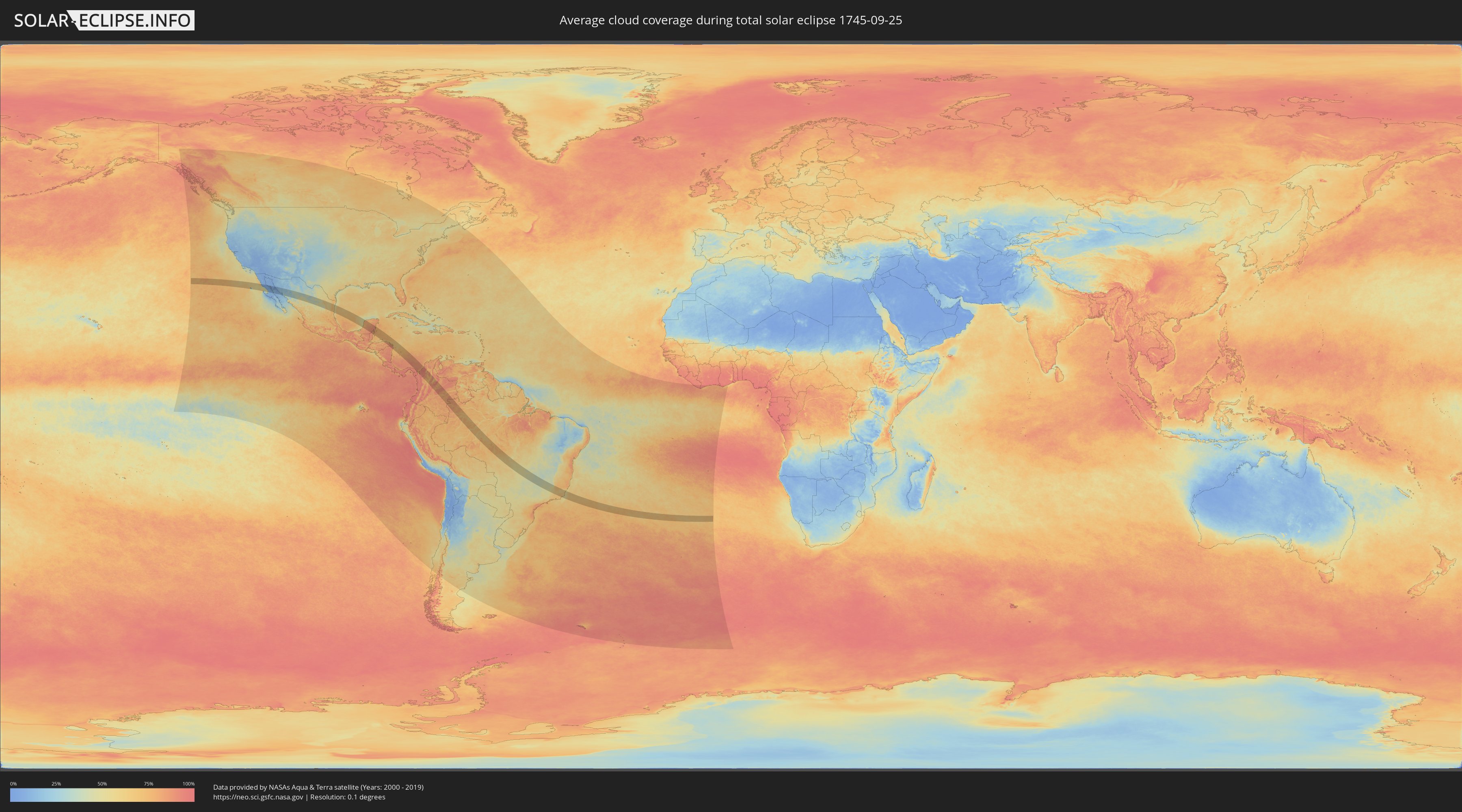
How will be the weather during the total solar eclipse on 09/25/1745?
Where is the best place to see the total solar eclipse of 09/25/1745?
The following maps show the average cloud coverage for the day of the total solar eclipse.
With the help of these maps, it is possible to find the place along the eclipse path, which has the best
chance of a cloudless sky.
Nevertheless, you should consider local circumstances and inform about the weather of your chosen
observation site.
The data is provided by NASAs satellites
AQUA and TERRA.
The cloud maps are averaged over a period of 19 years (2000 - 2019).

Detailed country maps
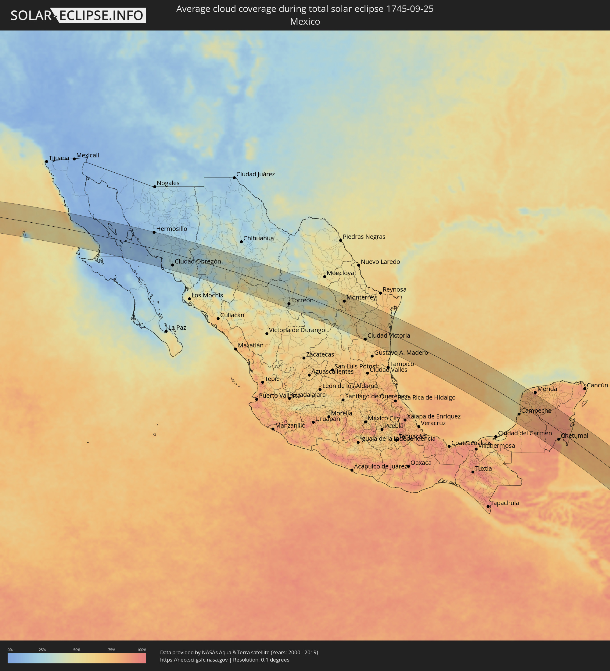 Mexico
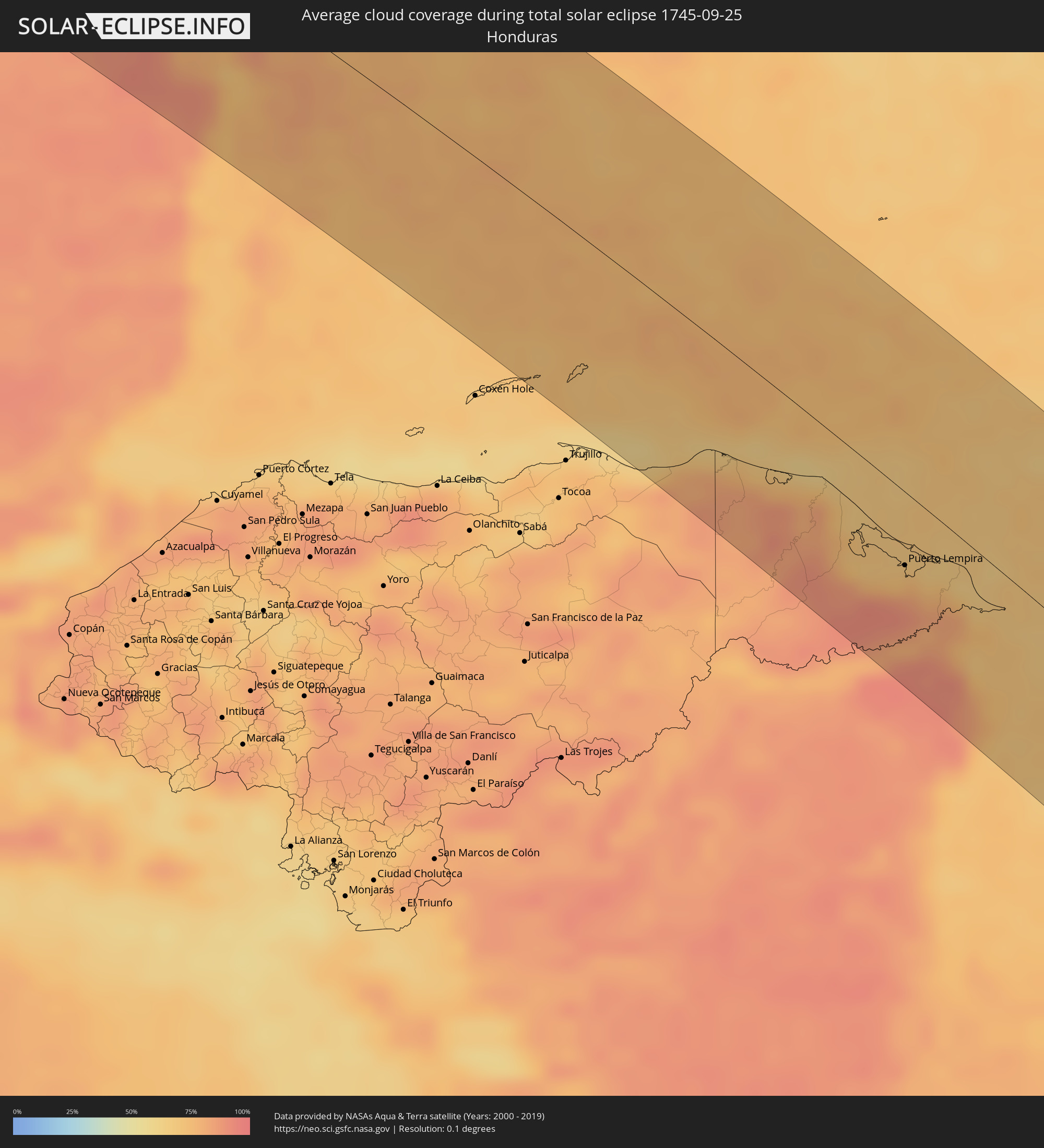 Honduras
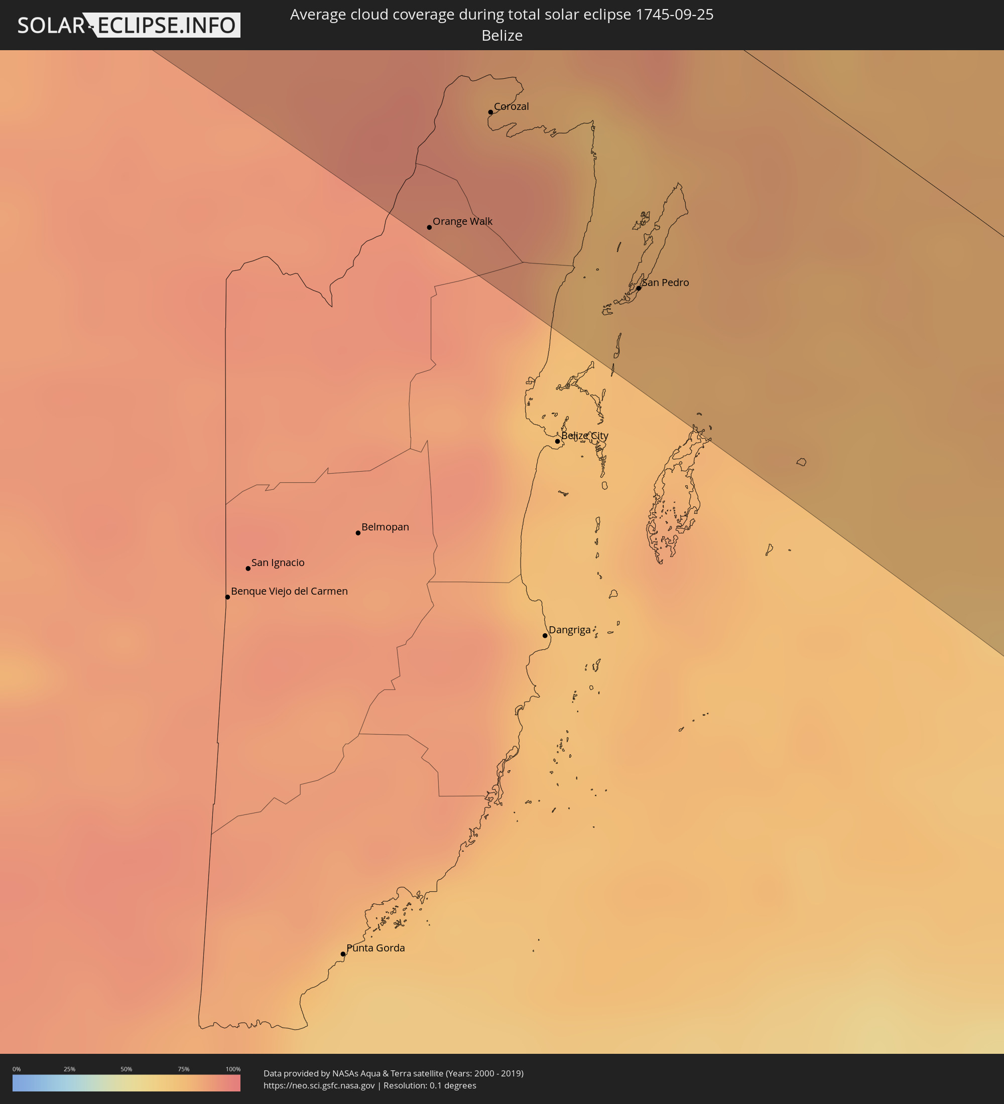 Belize
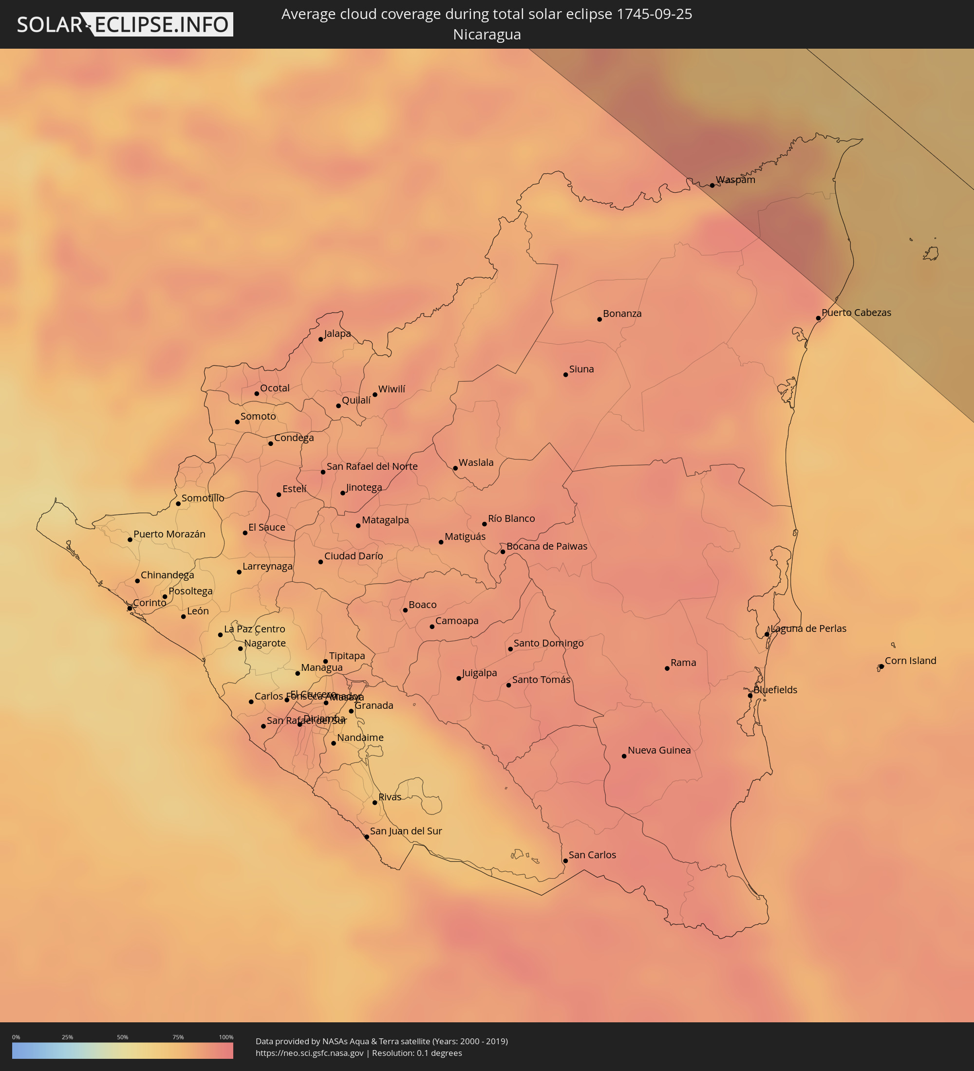 Nicaragua
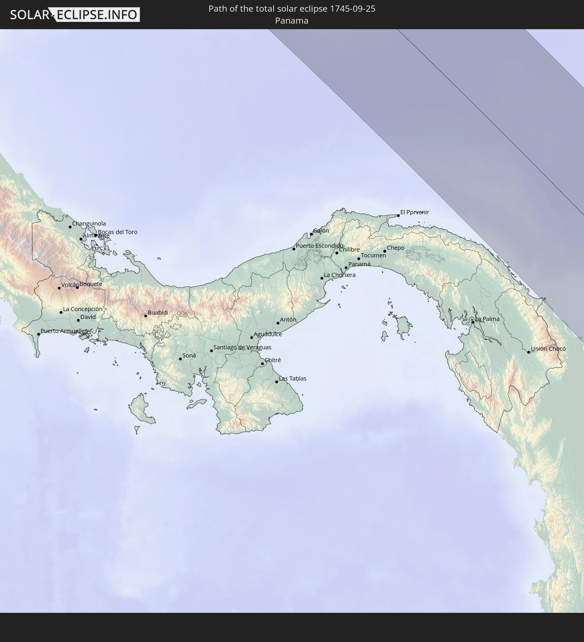
 Panama
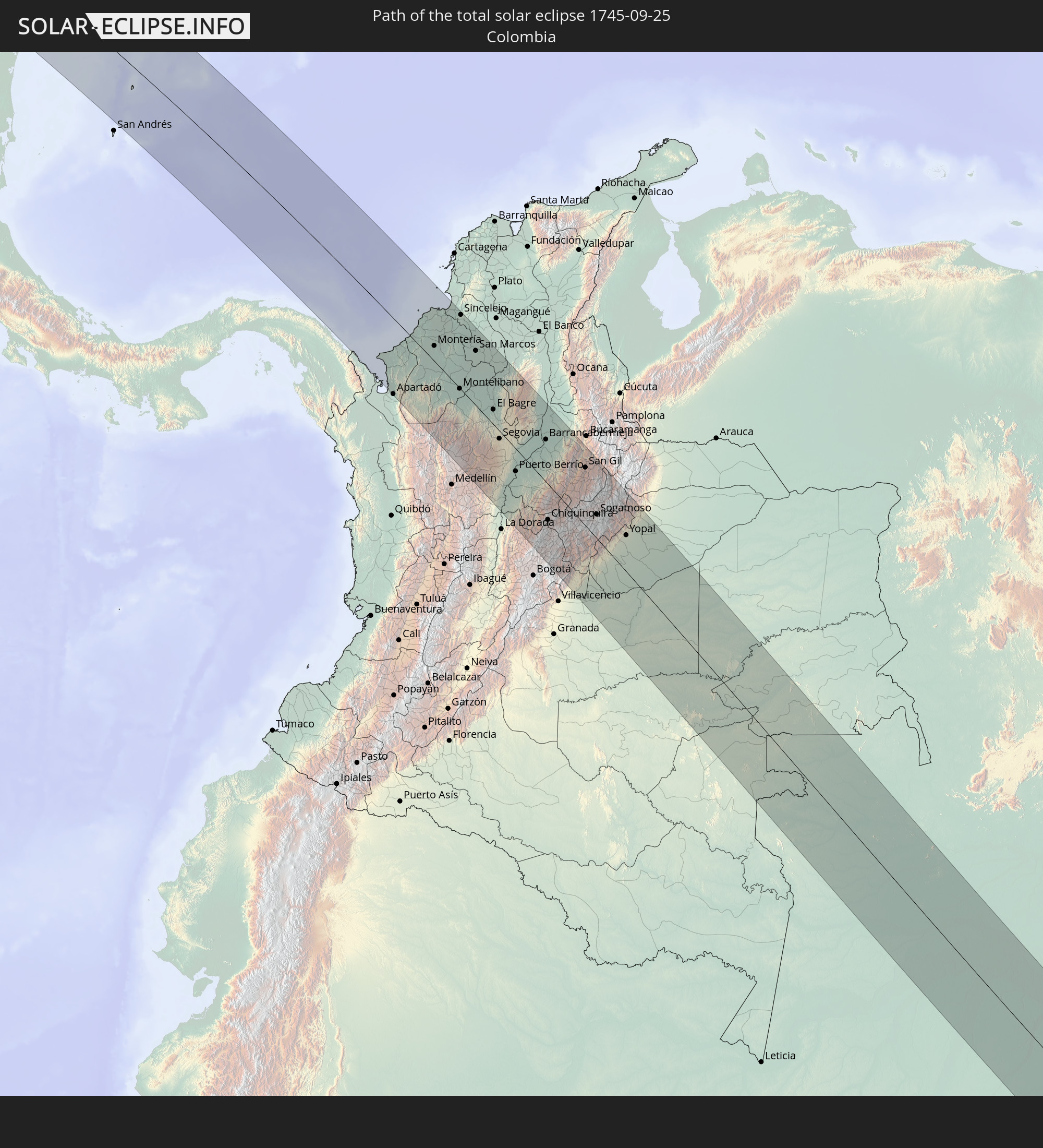
 Colombia
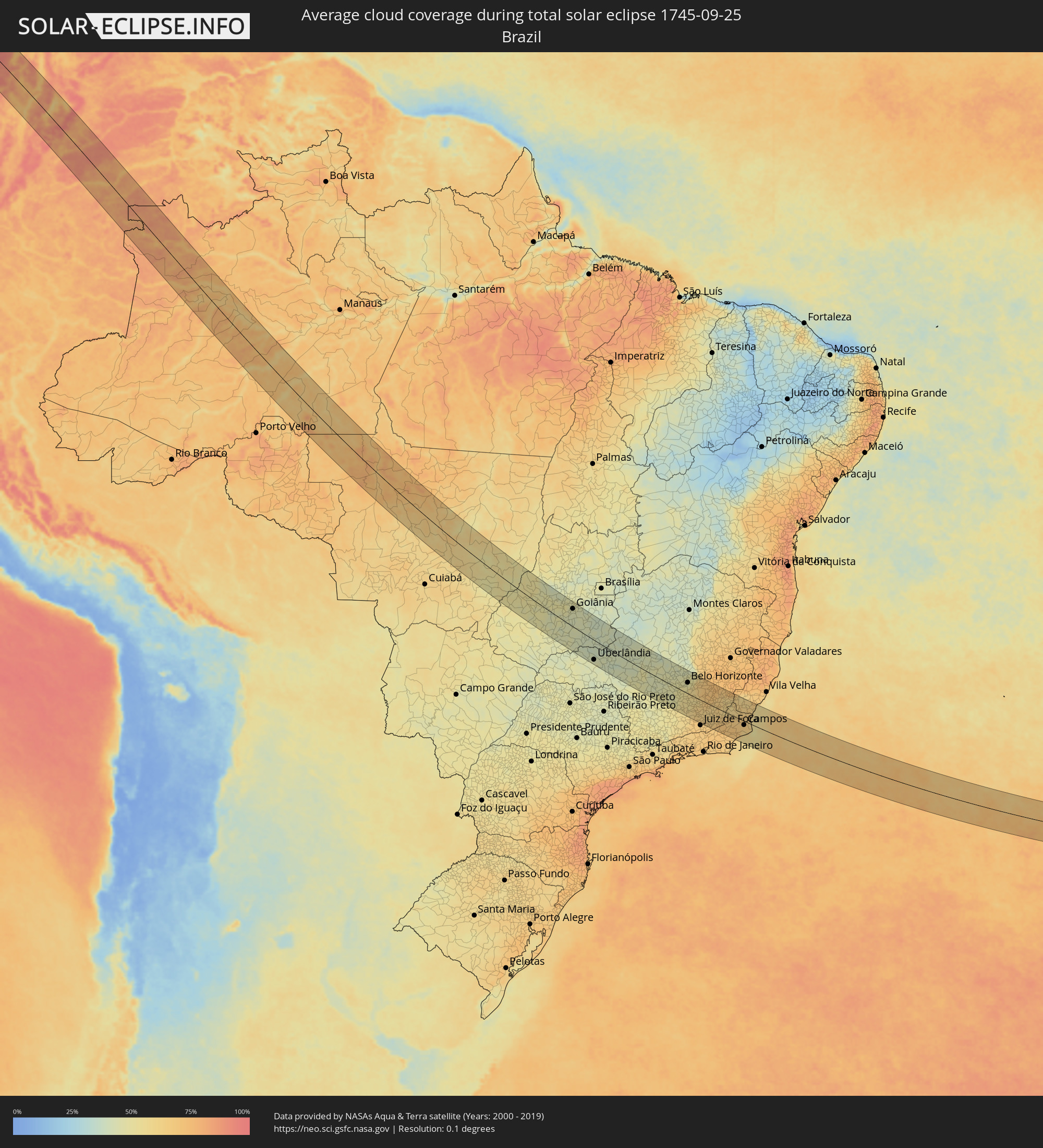 Brazil
Cities inside the path of the eclipse
The following table shows all locations with a population of more than 5,000 inside the eclipse path. Cities which have more than 100,000 inhabitants are marked bold. A click at the locations opens a detailed map.
| City | Type | Eclipse duration | Local time of max. eclipse | Distance to central line | Ø Cloud coverage |
|
Miguel Alemán (La Doce), Sonora
|
total | - | 07:28:23 UTC-07:23 | 45 km | 16% |
|
Hermosillo, Sonora
|
total | - | 07:28:36 UTC-07:23 | 85 km | 20% |
|
Heroica Guaymas, Sonora
|
total | - | 07:29:00 UTC-07:23 | 40 km | 13% |
|
Pueblo Yaqui, Sonora
|
total | - | 07:29:43 UTC-07:23 | 79 km | 28% |
|
Ciudad Obregón, Sonora
|
total | - | 07:29:44 UTC-07:23 | 62 km | 31% |
|
Hidalgo del Parral, Chihuahua
|
total | - | 07:51:12 UTC-07:05 | 1 km | 46% |
|
Torreon, Coahuila
|
total | - | 08:22:49 UTC-06:36 | 69 km | 39% |
|
Matamoros, Coahuila
|
total | - | 08:22:59 UTC-06:36 | 65 km | 41% |
|
Parras de la Fuente, Coahuila
|
total | - | 08:23:58 UTC-06:36 | 36 km | 49% |
|
Saltillo, Coahuila
|
total | - | 08:25:03 UTC-06:36 | 7 km | 56% |
|
García, Nuevo León
|
total | - | 08:25:11 UTC-06:36 | 62 km | 56% |
|
Mitras Poniente, Nuevo León
|
total | - | 08:25:22 UTC-06:36 | 65 km | 62% |
|
Monterrey, Nuevo León
|
total | - | 08:25:32 UTC-06:36 | 59 km | 62% |
|
Apodaca, Nuevo León
|
total | - | 08:25:38 UTC-06:36 | 74 km | 61% |
|
Fraccionamiento Real Palmas, Nuevo León
|
total | - | 08:25:32 UTC-06:36 | 89 km | 58% |
|
Santiago, Nuevo León
|
total | - | 08:25:51 UTC-06:36 | 40 km | 67% |
|
Allende, Nuevo León
|
total | - | 08:26:05 UTC-06:36 | 30 km | 64% |
|
Cadereyta, Nuevo León
|
total | - | 08:25:55 UTC-06:36 | 63 km | 59% |
|
Montemorelos, Nuevo León
|
total | - | 08:26:19 UTC-06:36 | 29 km | 62% |
|
Linares, Nuevo León
|
total | - | 08:26:48 UTC-06:36 | 5 km | 55% |
|
Ciudad Victoria, Tamaulipas
|
total | - | 08:28:01 UTC-06:36 | 91 km | 59% |
|
San Fernando, Tamaulipas
|
total | - | 08:28:13 UTC-06:36 | 63 km | 69% |
|
Campeche, Campeche
|
total | - | 08:41:48 UTC-06:36 | 49 km | 77% |
|
Calkiní, Campeche
|
total | - | 08:41:50 UTC-06:36 | 27 km | 78% |
|
Maxcanú, Yucatán
|
total | - | 08:41:39 UTC-06:36 | 50 km | 77% |
|
Hunucmá, Yucatán
|
total | - | 08:41:20 UTC-06:36 | 97 km | 77% |
|
Uman, Yucatán
|
total | - | 08:41:39 UTC-06:36 | 92 km | 80% |
|
Ticul, Yucatán
|
total | - | 08:42:29 UTC-06:36 | 59 km | 79% |
|
Oxkutzkab, Yucatán
|
total | - | 08:42:45 UTC-06:36 | 57 km | 81% |
|
Tecax, Yucatán
|
total | - | 08:43:02 UTC-06:36 | 55 km | 81% |
|
Peto, Yucatán
|
total | - | 08:43:37 UTC-06:36 | 69 km | 82% |
|
Orange Walk, Orange Walk
|
total | - | 09:30:25 UTC-05:52 | 98 km | 89% |
|
Bacalar, Quintana Roo
|
total | - | 09:35:38 UTC-05:47 | 33 km | 86% |
|
Corozal, Corozal
|
total | - | 09:30:16 UTC-05:52 | 59 km | 83% |
|
Chetumal, Quintana Roo
|
total | - | 09:35:58 UTC-05:47 | 43 km | 78% |
|
Felipe Carrillo Puerto, Quintana Roo
|
total | - | 09:35:00 UTC-05:47 | 70 km | 87% |
|
San Pedro, Belize
|
total | - | 09:31:28 UTC-05:52 | 77 km | 75% |
|
Waspam, Atlántico Norte (RAAN)
|
total | - | 09:49:32 UTC-05:45 | 98 km | 91% |
|
Puerto Lempira, Gracias a Dios
|
total | - | 09:45:22 UTC-05:48 | 39 km | 74% |
|
Turbo, Antioquia
|
total | - | 11:02:02 UTC-04:56 | 97 km | 87% |
|
Apartadó, Antioquia
|
total | - | 11:02:37 UTC-04:56 | 105 km | 93% |
|
Tierralta, Córdoba
|
total | - | 11:03:03 UTC-04:56 | 37 km | 92% |
|
Montería, Córdoba
|
total | - | 11:02:16 UTC-04:56 | 21 km | 93% |
|
Lorica, Córdoba
|
total | - | 11:01:27 UTC-04:56 | 64 km | 88% |
|
Cereté, Córdoba
|
total | - | 11:02:10 UTC-04:56 | 39 km | 96% |
|
Ciénaga de Oro, Córdoba
|
total | - | 11:02:29 UTC-04:56 | 52 km | 93% |
|
Planeta Rica, Córdoba
|
total | - | 11:03:26 UTC-04:56 | 19 km | 91% |
|
Tolú, Sucre
|
total | - | 11:01:19 UTC-04:56 | 105 km | 86% |
|
Sahagún, Córdoba
|
total | - | 11:02:39 UTC-04:56 | 71 km | 91% |
|
Montelíbano, Córdoba
|
total | - | 11:04:33 UTC-04:56 | 1 km | 90% |
|
Yarumal, Antioquia
|
total | - | 11:06:31 UTC-04:56 | 78 km | 82% |
|
Chinú, Córdoba
|
total | - | 11:02:26 UTC-04:56 | 87 km | 92% |
|
Sincelejo, Sucre
|
total | - | 11:02:03 UTC-04:56 | 102 km | 94% |
|
Caucasia, Antioquia
|
total | - | 11:04:56 UTC-04:56 | 18 km | 78% |
|
Ayapel, Córdoba
|
total | - | 11:04:24 UTC-04:56 | 47 km | 83% |
|
San Marcos, Sucre
|
total | - | 11:03:45 UTC-04:56 | 75 km | 72% |
|
San Benito Abad, Sucre
|
total | - | 11:03:25 UTC-04:56 | 103 km | 71% |
|
El Bagre, Antioquia
|
total | - | 11:06:21 UTC-04:56 | 20 km | 74% |
|
San Carlos, Antioquia
|
total | - | 11:06:03 UTC-04:56 | 37 km | 77% |
|
Segovia, Antioquia
|
total | - | 11:07:34 UTC-04:56 | 10 km | 77% |
|
Puerto Boyacá, Boyacá
|
total | - | 11:09:56 UTC-04:56 | 84 km | 67% |
|
Puerto Berrío, Antioquia
|
total | - | 11:09:15 UTC-04:56 | 31 km | 65% |
|
La Mesa, Cundinamarca
|
total | - | 11:12:33 UTC-04:56 | 82 km | 89% |
|
Barrancabermeja, Santander
|
total | - | 11:09:05 UTC-04:56 | 57 km | 76% |
|
Chiquinquirá, Boyacá
|
total | - | 11:12:02 UTC-04:56 | 48 km | 83% |
|
Barbosa, Santander
|
total | - | 11:11:46 UTC-04:56 | 8 km | 75% |
|
Tunja, Boyacá
|
total | - | 11:13:00 UTC-04:56 | 17 km | 87% |
|
Socorro, Santander
|
total | - | 11:11:20 UTC-04:56 | 61 km | 60% |
|
San Gil, Santander
|
total | - | 11:11:22 UTC-04:56 | 78 km | 65% |
|
Duitama, Boyacá
|
total | - | 11:13:01 UTC-04:56 | 32 km | 83% |
|
Sogamoso, Boyacá
|
total | - | 11:13:25 UTC-04:56 | 32 km | 85% |
|
Yopal, Casanare
|
total | - | 11:15:08 UTC-04:56 | 49 km | 81% |
|
Villanueva, Casanare
|
total | - | 11:16:01 UTC-04:56 | 80 km | 76% |
|
Sinop, Mato Grosso
|
total | - | 13:37:07 UTC-03:38 | 97 km | 68% |
|
Trindade, Goiás
|
total | - | 14:25:48 UTC-03:06 | 63 km | 46% |
|
Goiânia, Goiás
|
total | - | 14:26:11 UTC-03:06 | 74 km | 43% |
|
Aparecida de Goiânia, Goiás
|
total | - | 14:26:23 UTC-03:06 | 61 km | 43% |
|
Itumbiara, Goiás
|
total | - | 14:28:28 UTC-03:06 | 87 km | 43% |
|
Caldas Novas, Goiás
|
total | - | 14:28:27 UTC-03:06 | 10 km | 40% |
|
Uberlândia, Minas Gerais
|
total | - | 14:30:23 UTC-03:06 | 81 km | 43% |
|
Araguari, Minas Gerais
|
total | - | 14:30:11 UTC-03:06 | 50 km | 38% |
|
Catalão, Goiás
|
total | - | 14:29:56 UTC-03:06 | 9 km | 41% |
|
Patrocínio, Minas Gerais
|
total | - | 14:32:11 UTC-03:06 | 14 km | 42% |
|
Araxá, Minas Gerais
|
total | - | 14:32:59 UTC-03:06 | 73 km | 44% |
|
Patos de Minas, Minas Gerais
|
total | - | 14:32:24 UTC-03:06 | 47 km | 41% |
|
Divinópolis, Minas Gerais
|
total | - | 14:36:16 UTC-03:06 | 22 km | 46% |
|
Pará de Minas, Minas Gerais
|
total | - | 14:36:20 UTC-03:06 | 20 km | 48% |
|
Itaúna, Minas Gerais
|
total | - | 14:36:36 UTC-03:06 | 0 km | 47% |
|
Esmeraldas, Minas Gerais
|
total | - | 14:36:36 UTC-03:06 | 44 km | 48% |
|
São João del Rei, Minas Gerais
|
total | - | 14:38:04 UTC-03:06 | 89 km | 55% |
|
Sete Lagoas, Minas Gerais
|
total | - | 14:36:23 UTC-03:06 | 77 km | 43% |
|
Betim, Minas Gerais
|
total | - | 14:36:58 UTC-03:06 | 29 km | 52% |
|
Ribeirão das Neves, Minas Gerais
|
total | - | 14:36:54 UTC-03:06 | 55 km | 47% |
|
Ibirité, Minas Gerais
|
total | - | 14:37:12 UTC-03:06 | 31 km | 50% |
|
Belo Horizonte, Minas Gerais
|
total | - | 14:37:15 UTC-03:06 | 47 km | 47% |
|
Santa Luzia, Minas Gerais
|
total | - | 14:37:12 UTC-03:06 | 66 km | 48% |
|
Conselheiro Lafaiete, Minas Gerais
|
total | - | 14:38:11 UTC-03:06 | 19 km | 55% |
|
Barbacena, Minas Gerais
|
total | - | 14:38:45 UTC-03:06 | 75 km | 59% |
|
Ouro Preto, Minas Gerais
|
total | - | 14:38:16 UTC-03:06 | 20 km | 60% |
|
João Monlevade, Minas Gerais
|
total | - | 14:38:06 UTC-03:06 | 94 km | 66% |
|
Ubá, Minas Gerais
|
total | - | 14:39:40 UTC-03:06 | 26 km | 60% |
|
Viçosa, Minas Gerais
|
total | - | 14:39:23 UTC-03:06 | 14 km | 65% |
|
Cataguases, Minas Gerais
|
total | - | 14:40:12 UTC-03:06 | 41 km | 64% |
|
Muriaé, Minas Gerais
|
total | - | 14:40:22 UTC-03:06 | 1 km | 60% |
|
Itaperuna, Rio de Janeiro
|
total | - | 14:41:00 UTC-03:06 | 14 km | 61% |
|
Campos, Rio de Janeiro
|
total | - | 14:42:08 UTC-03:06 | 17 km | 66% |
|
Cachoeiro de Itapemirim, Espírito Santo
|
total | - | 14:41:35 UTC-03:06 | 84 km | 61% |