Total solar eclipse of 08/29/1867
| Day of week: | Thursday |
| Maximum duration of eclipse: | 02m51s |
| Maximum width of eclipse path: | 189 km |
| Saros cycle: | 123 |
| Coverage: | 100% |
| Magnitude: | 1.0344 |
| Gamma: | -0.794 |
Wo kann man die Sonnenfinsternis vom 08/29/1867 sehen?

Die Sonnenfinsternis am 08/29/1867 kann man in 22 Ländern als partielle Sonnenfinsternis beobachten.
Der Finsternispfad verläuft durch 3 Länder. Nur in diesen Ländern ist sie als total Sonnenfinsternis zu sehen.
In den folgenden Ländern ist die Sonnenfinsternis total zu sehen
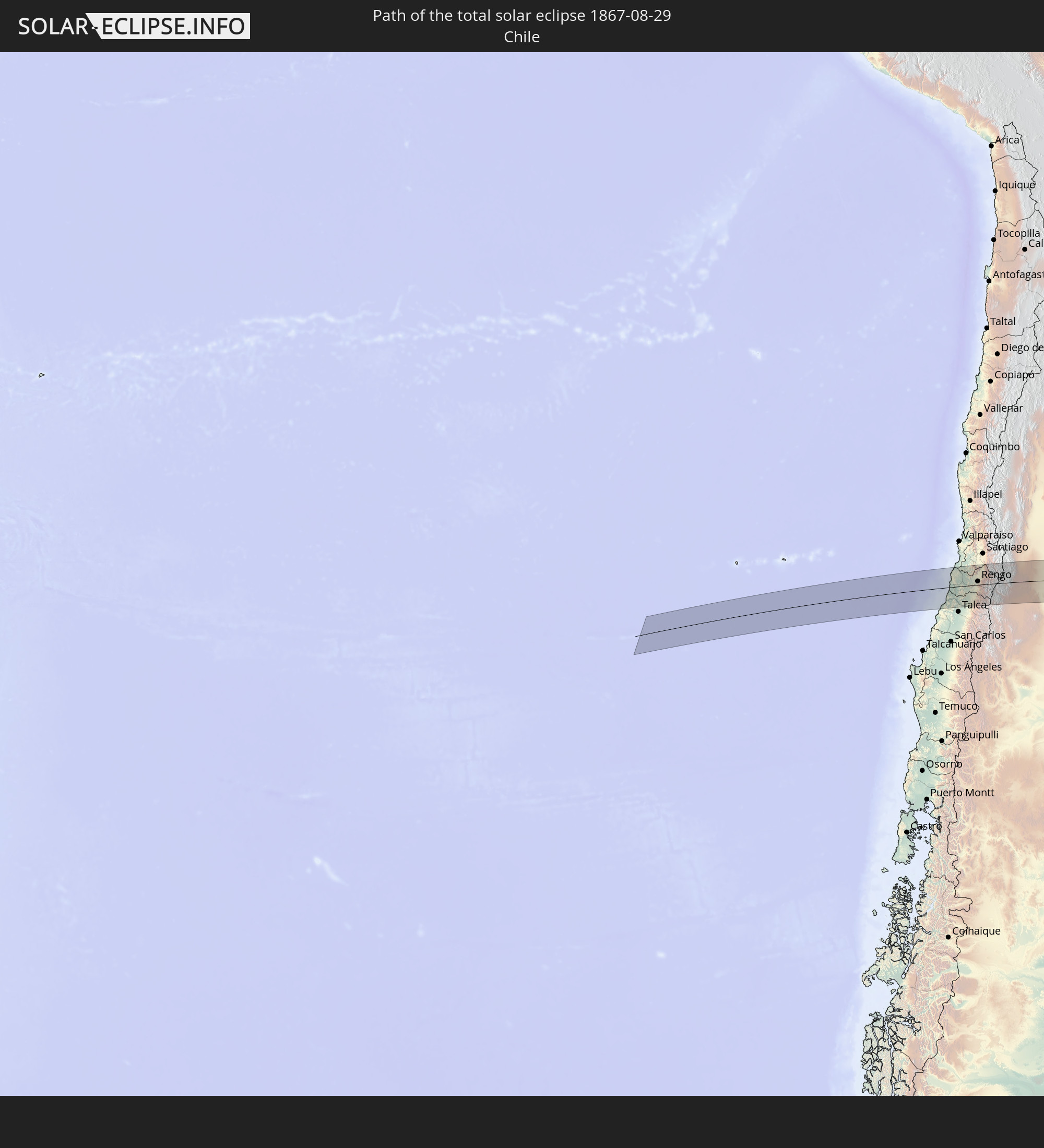 Chile
Chile
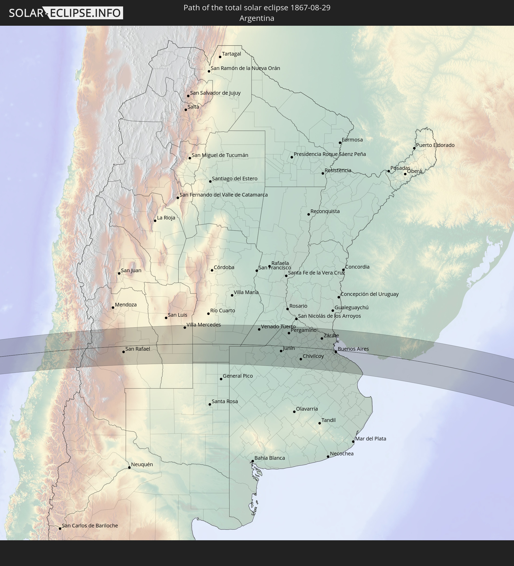 Argentina
 Uruguay
In den folgenden Ländern ist die Sonnenfinsternis partiell zu sehen


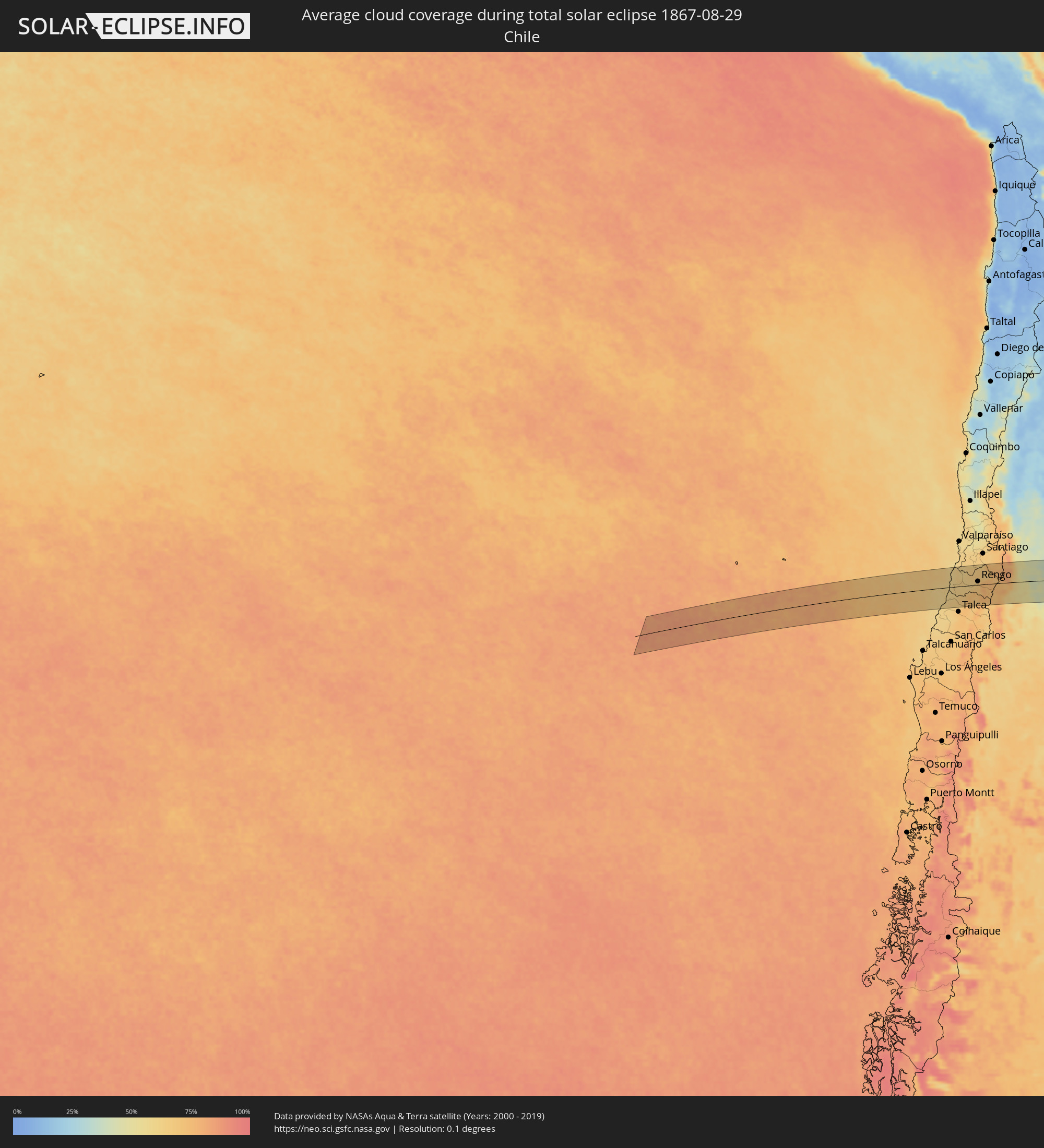
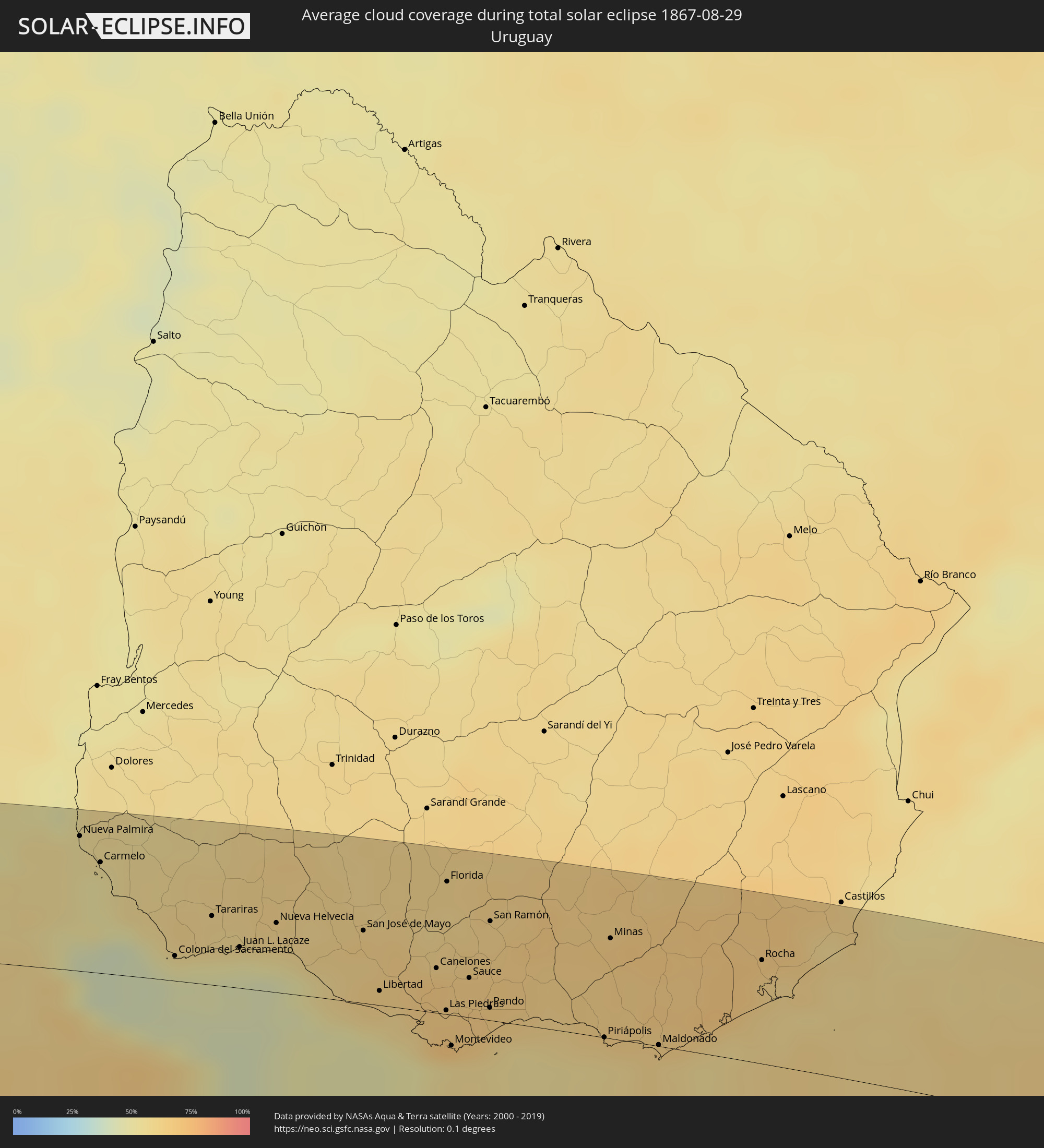
How will be the weather during the total solar eclipse on 08/29/1867?
Where is the best place to see the total solar eclipse of 08/29/1867?
The following maps show the average cloud coverage for the day of the total solar eclipse.
With the help of these maps, it is possible to find the place along the eclipse path, which has the best
chance of a cloudless sky.
Nevertheless, you should consider local circumstances and inform about the weather of your chosen
observation site.
The data is provided by NASAs satellites
AQUA and TERRA.
The cloud maps are averaged over a period of 19 years (2000 - 2019).


Detailed country maps
 Chile
Chile
 Argentina
 Uruguay
Cities inside the path of the eclipse
The following table shows all locations with a population of more than 5,000 inside the eclipse path. Cities which have more than 100,000 inhabitants are marked bold. A click at the locations opens a detailed map.
| City | Type | Eclipse duration | Local time of max. eclipse | Distance to central line | Ø Cloud coverage |
 Santa Cruz, O'Higgins
|
total | - | 07:29:55 UTC-04:42 | 9 km | 63% |
|
Rauco, Maule
|
total | - | 07:30:23 UTC-04:42 | 41 km | 71% |
|
Molina, Maule
|
total | - | 07:30:42 UTC-04:42 | 63 km | 72% |
|
Curicó, Maule
|
total | - | 07:30:32 UTC-04:42 | 48 km | 74% |
|
Teno, Maule
|
total | - | 07:30:25 UTC-04:42 | 36 km | 73% |
|
San Vicente, O'Higgins
|
total | - | 07:29:48 UTC-04:42 | 11 km | 62% |
|
San Vicente de Tagua Tagua, O'Higgins
|
total | - | 07:29:48 UTC-04:42 | 11 km | 62% |
|
Chimbarongo, O'Higgins
|
total | - | 07:30:15 UTC-04:42 | 20 km | 73% |
|
Rengo, O'Higgins
|
total | - | 07:29:55 UTC-04:42 | 13 km | 65% |
|
Rancagua, O'Higgins
|
total | - | 07:29:38 UTC-04:42 | 38 km | 67% |
|
Graneros, O'Higgins
|
total | - | 07:29:29 UTC-04:42 | 49 km | 67% |
|
Machalí, O'Higgins
|
total | - | 07:29:43 UTC-04:42 | 36 km | 66% |
 San Rafael, Mendoza Province
|
total | - | 07:58:11 UTC-04:16 | 26 km | 47% |
|
Villa Mercedes, San Luis Province
|
total | - | 07:59:15 UTC-04:16 | 70 km | 50% |
|
Justo Daract, San Luis Province
|
total | - | 07:59:48 UTC-04:16 | 49 km | 56% |
|
Coronel Moldes, Cordoba Province
|
total | - | 08:00:00 UTC-04:16 | 75 km | 56% |
|
Villa Huidobro, Cordoba Province
|
total | - | 08:01:55 UTC-04:16 | 60 km | 66% |
|
Vicuña Mackenna, Cordoba Province
|
total | - | 08:00:40 UTC-04:16 | 42 km | 60% |
|
Huinca Renancó, Cordoba Province
|
total | - | 08:02:08 UTC-04:16 | 60 km | 63% |
|
Realicó, La Pampa Province
|
total | - | 08:02:34 UTC-04:16 | 82 km | 66% |
|
Adelia María, Cordoba Province
|
total | - | 08:00:35 UTC-04:16 | 75 km | 60% |
|
General Levalle, Cordoba Province
|
total | - | 08:01:17 UTC-04:16 | 32 km | 64% |
|
Laboulaye, Cordoba Province
|
total | - | 08:02:00 UTC-04:16 | 20 km | 65% |
|
Canals, Cordoba Province
|
total | - | 08:01:39 UTC-04:16 | 83 km | 62% |
|
Rufino, Santa Fe Province
|
total | - | 08:02:56 UTC-04:16 | 6 km | 67% |
|
Arias, Cordoba Province
|
total | - | 08:02:17 UTC-04:16 | 76 km | 63% |
|
Venado Tuerto, Santa Fe Province
|
total | - | 08:02:55 UTC-04:16 | 66 km | 59% |
|
Villa Cañás, Santa Fe Province
|
total | - | 08:03:44 UTC-04:16 | 38 km | 60% |
|
Lincoln, Buenos Aires
|
total | - | 08:05:10 UTC-04:16 | 57 km | 62% |
|
Junín, Buenos Aires
|
total | - | 08:05:23 UTC-04:16 | 23 km | 64% |
|
Pergamino, Buenos Aires
|
total | - | 08:04:43 UTC-04:16 | 56 km | 64% |
|
Chacabuco, Buenos Aires
|
total | - | 08:06:01 UTC-04:16 | 27 km | 60% |
|
Chivilcoy, Buenos Aires
|
total | - | 08:06:57 UTC-04:16 | 52 km | 65% |
|
Mercedes, Buenos Aires
|
total | - | 08:07:16 UTC-04:16 | 21 km | 62% |
|
Luján, Buenos Aires
|
total | - | 08:07:32 UTC-04:16 | 10 km | 62% |
|
Zárate, Buenos Aires
|
total | - | 08:06:52 UTC-04:16 | 43 km | 59% |
|
Campana, Buenos Aires
|
total | - | 08:07:04 UTC-04:16 | 36 km | 61% |
|
Pontevedra, Buenos Aires
|
total | - | 08:08:18 UTC-04:16 | 26 km | 59% |
|
Morón, Buenos Aires
|
total | - | 08:08:15 UTC-04:16 | 15 km | 59% |
|
Tigre, Buenos Aires
|
total | - | 08:07:57 UTC-04:16 | 11 km | 57% |
|
San Isidro, Buenos Aires
|
total | - | 08:08:05 UTC-04:16 | 6 km | 58% |
|
Villa Santa Rita, Buenos Aires F.D.
|
total | - | 08:08:22 UTC-04:16 | 9 km | 63% |
|
Villa Lugano, Buenos Aires F.D.
|
total | - | 08:08:29 UTC-04:16 | 16 km | 62% |
|
Colegiales, Buenos Aires F.D.
|
total | - | 08:08:20 UTC-04:16 | 4 km | 60% |
 Nueva Palmira, Colonia
|
total | - | 08:39:14 UTC-03:44 | 74 km | 53% |
|
Adrogué, Buenos Aires
|
total | - | 08:08:47 UTC-04:16 | 29 km | 61% |
|
Retiro, Buenos Aires F.D.
|
total | - | 08:08:26 UTC-04:16 | 5 km | 60% |
|
Buenos Aires, Buenos Aires F.D.
|
total | - | 08:08:30 UTC-04:16 | 8 km | 60% |
|
Carmelo, Colonia
|
total | - | 08:39:35 UTC-03:44 | 61 km | 51% |
|
Quilmes, Buenos Aires
|
total | - | 08:08:49 UTC-04:16 | 20 km | 59% |
|
La Plata, Buenos Aires
|
total | - | 08:09:31 UTC-04:16 | 38 km | 66% |
|
Colonia del Sacramento, Colonia
|
total | - | 08:40:53 UTC-03:44 | 14 km | 45% |
|
Tarariras, Colonia
|
total | - | 08:40:51 UTC-03:44 | 38 km | 57% |
|
Juan L. Lacaze, Colonia
|
total | - | 08:41:18 UTC-03:44 | 22 km | 49% |
|
Rosario, Colonia
|
total | - | 08:41:17 UTC-03:44 | 35 km | 57% |
|
Nueva Helvecia, Colonia
|
total | - | 08:41:24 UTC-03:44 | 38 km | 58% |
|
San José de Mayo, San José
|
total | - | 08:42:09 UTC-03:44 | 39 km | 63% |
|
Libertad, San José
|
total | - | 08:42:44 UTC-03:44 | 8 km | 61% |
|
Santa Lucía, Canelones
|
total | - | 08:42:45 UTC-03:44 | 31 km | 65% |
|
Delta del Tigre, San José
|
total | - | 08:43:17 UTC-03:44 | 4 km | 55% |
|
Canelones, Canelones
|
total | - | 08:43:01 UTC-03:44 | 24 km | 66% |
|
La Paz, Canelones
|
total | - | 08:43:28 UTC-03:44 | 1 km | 69% |
|
Las Piedras, Canelones
|
total | - | 08:43:25 UTC-03:44 | 2 km | 67% |
|
Progreso, Canelones
|
total | - | 08:43:19 UTC-03:44 | 9 km | 67% |
|
Florida, Florida
|
total | - | 08:42:26 UTC-03:44 | 72 km | 59% |
|
Montevideo, Montevideo
|
total | - | 08:43:44 UTC-03:44 | 17 km | 56% |
|
Sauce, Canelones
|
total | - | 08:43:21 UTC-03:44 | 21 km | 66% |
|
Paso de Carrasco, Canelones
|
total | - | 08:43:51 UTC-03:44 | 10 km | 57% |
|
Joaquín Suárez, Canelones
|
total | - | 08:43:41 UTC-03:44 | 4 km | 66% |
|
Colonia Nicolich, Canelones
|
total | - | 08:43:49 UTC-03:44 | 5 km | 63% |
|
Pando, Canelones
|
total | - | 08:43:45 UTC-03:44 | 7 km | 66% |
|
San Ramón, Canelones
|
total | - | 08:43:05 UTC-03:44 | 54 km | 62% |
|
Piriápolis, Maldonado
|
total | - | 08:44:55 UTC-03:44 | 0 km | 55% |
|
Minas, Lavalleja
|
total | - | 08:44:12 UTC-03:44 | 54 km | 65% |
|
Pan de Azúcar, Maldonado
|
total | - | 08:44:50 UTC-03:44 | 10 km | 62% |
|
Maldonado, Maldonado
|
total | - | 08:45:25 UTC-03:44 | 1 km | 61% |
|
Punta del Este, Maldonado
|
total | - | 08:45:31 UTC-03:44 | 4 km | 59% |
|
San Carlos, Maldonado
|
total | - | 08:45:18 UTC-03:44 | 13 km | 64% |
|
Rocha, Rocha
|
total | - | 08:45:38 UTC-03:44 | 56 km | 62% |