Total solar eclipse of 08/18/1868
| Day of week: | Tuesday |
| Maximum duration of eclipse: | 06m47s |
| Maximum width of eclipse path: | 245 km |
| Saros cycle: | 133 |
| Coverage: | 100% |
| Magnitude: | 1.0756 |
| Gamma: | -0.0443 |
Wo kann man die Sonnenfinsternis vom 08/18/1868 sehen?
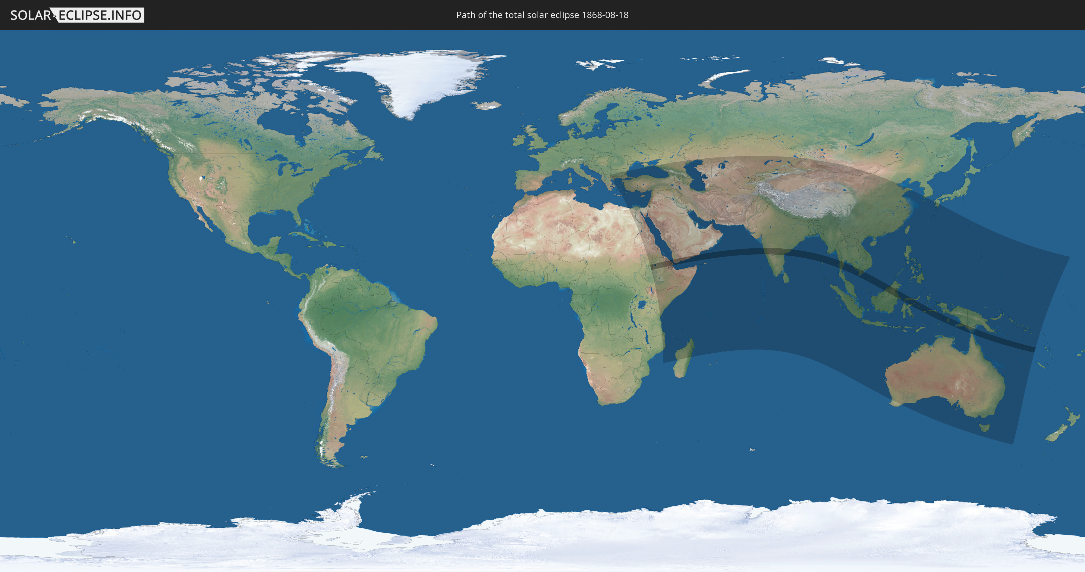
Die Sonnenfinsternis am 08/18/1868 kann man in 83 Ländern als partielle Sonnenfinsternis beobachten.
Der Finsternispfad verläuft durch 14 Länder. Nur in diesen Ländern ist sie als total Sonnenfinsternis zu sehen.
In den folgenden Ländern ist die Sonnenfinsternis total zu sehen
 Ethiopia
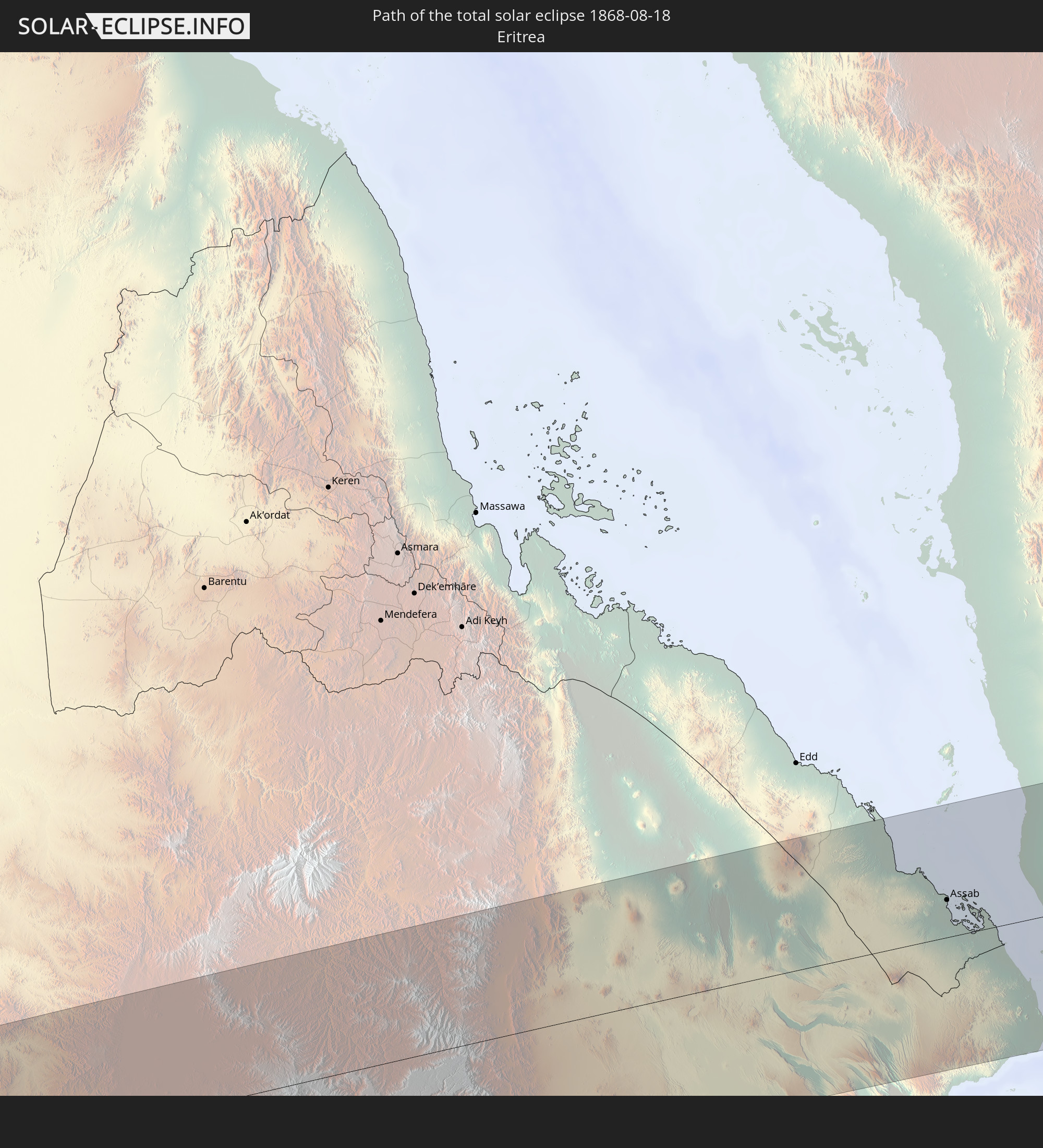 Eritrea
 Djibouti
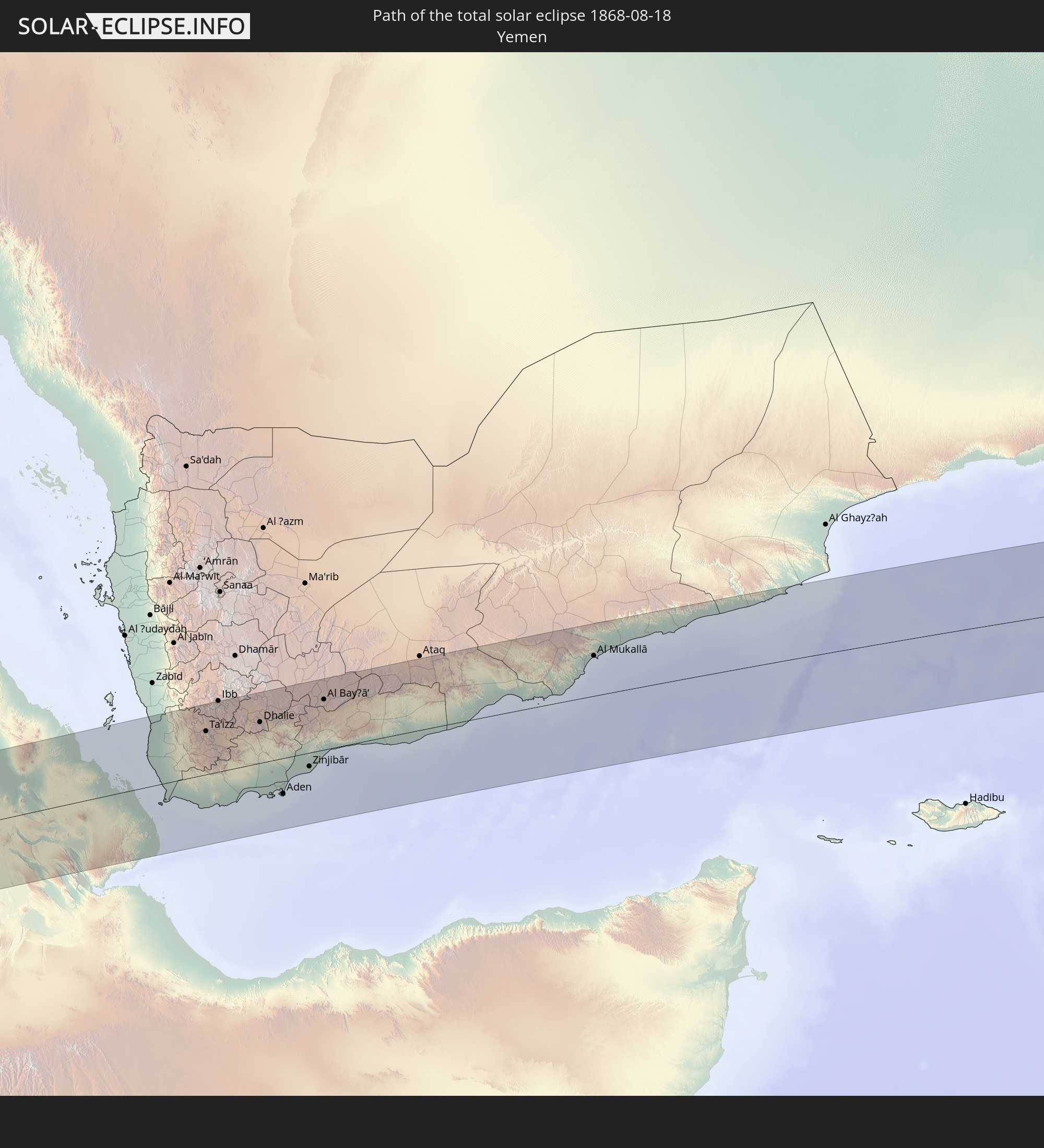 Yemen
Yemen
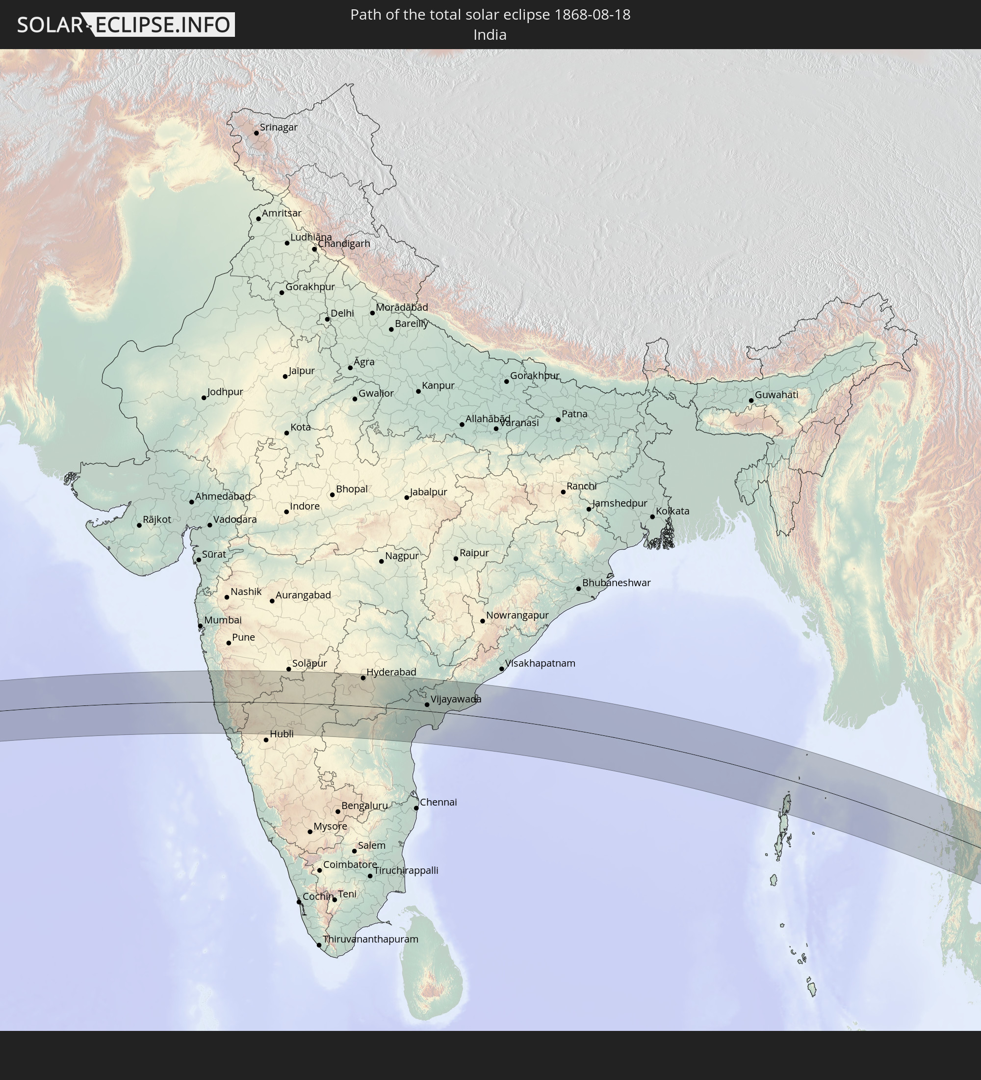 India
India
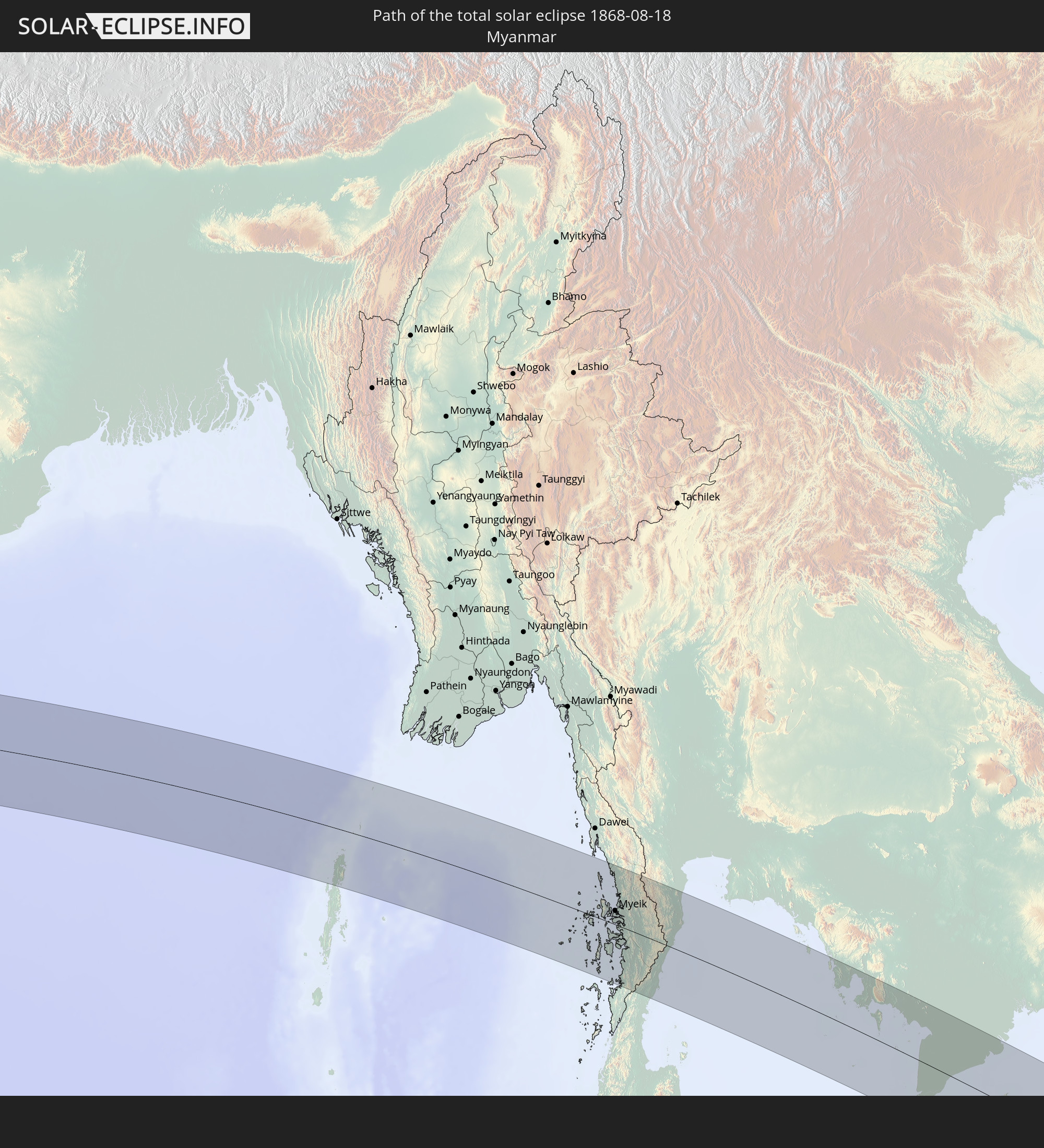 Myanmar
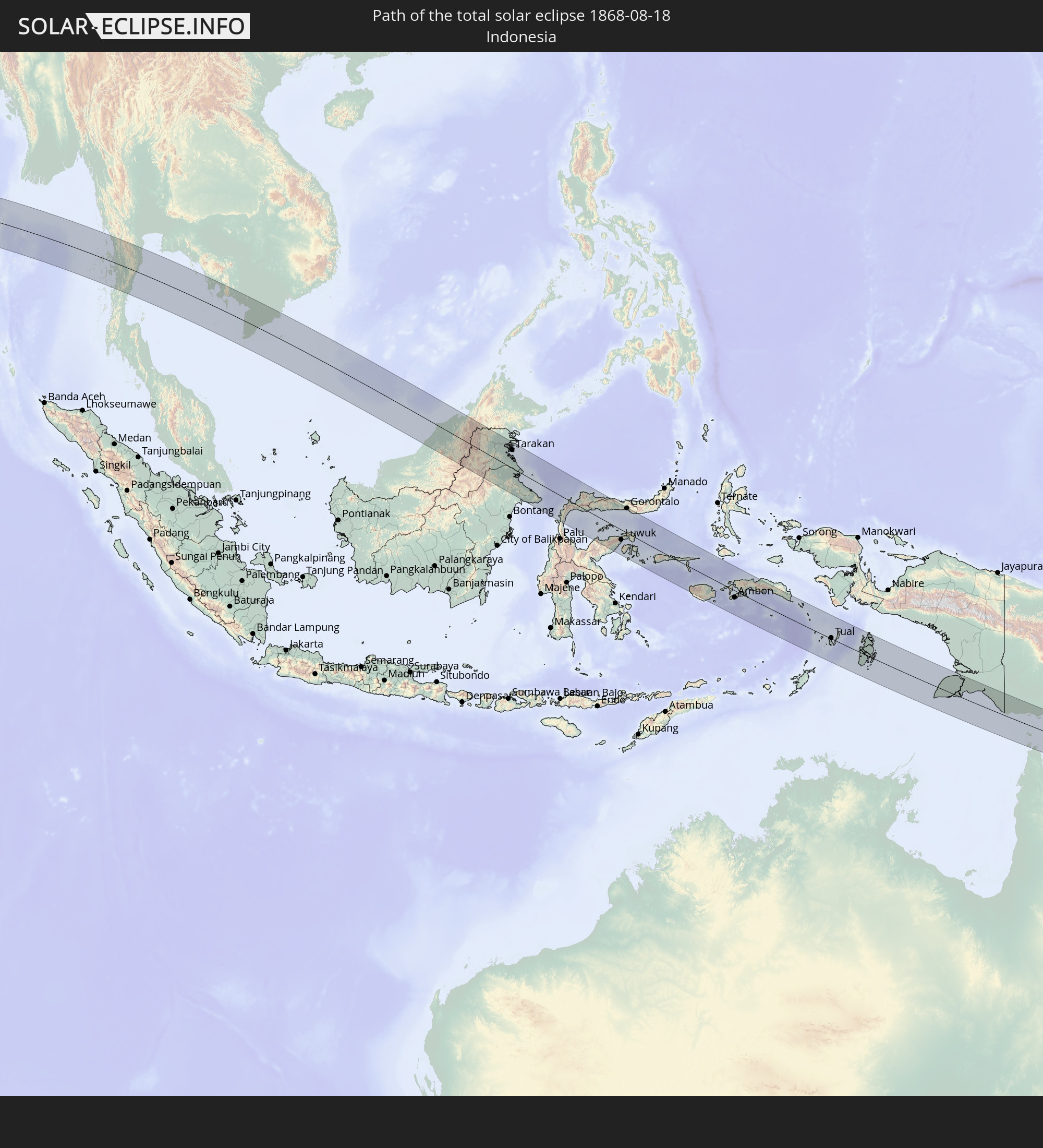 Indonesia
 Thailand
 Malaysia
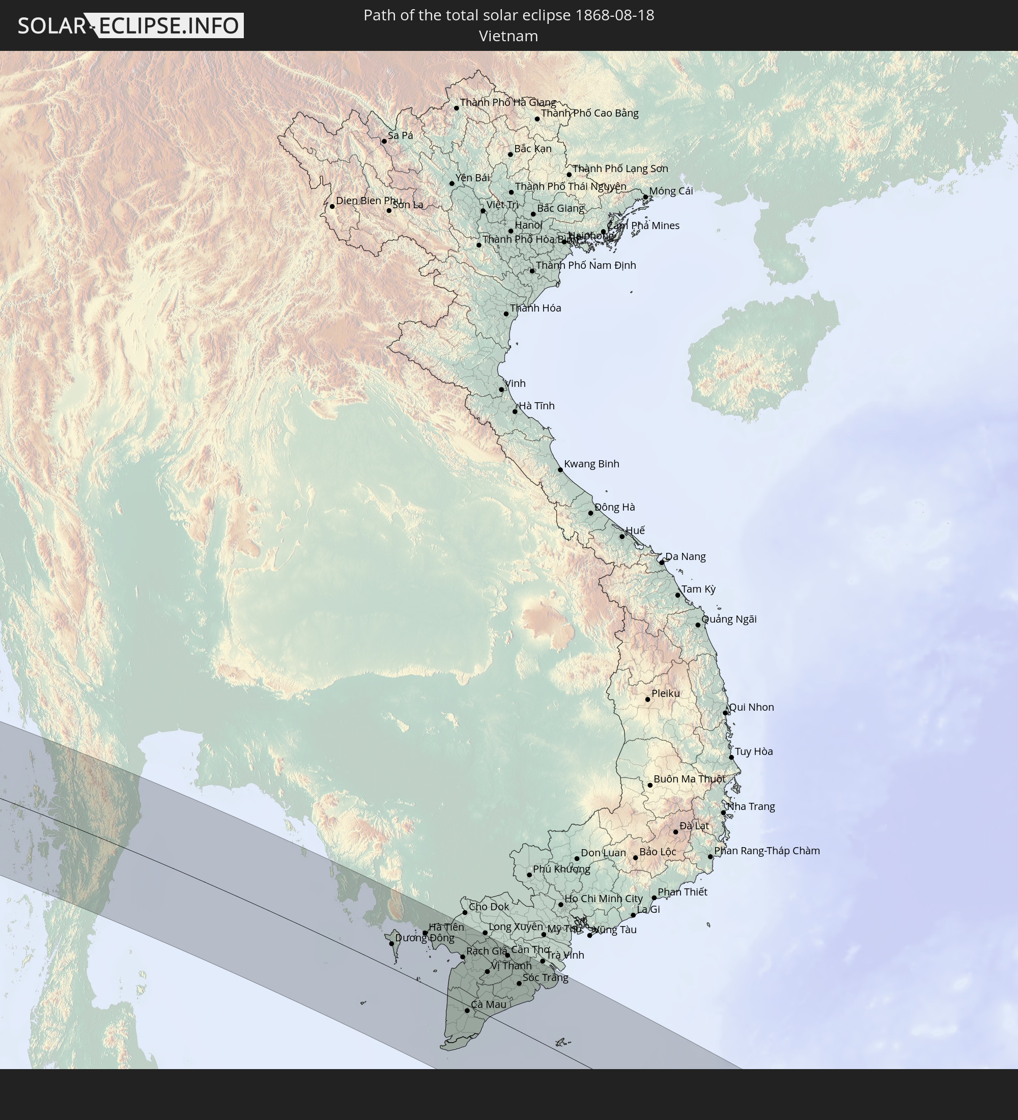 Vietnam
 Cambodia
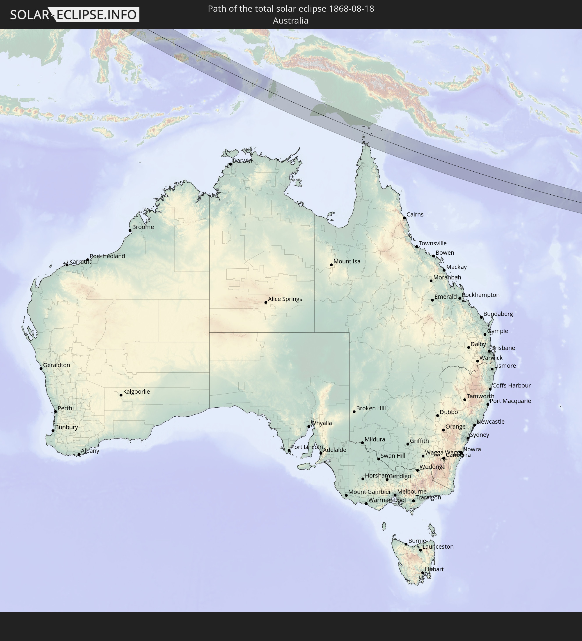 Australia
 Brunei
 Papua New Guinea
In den folgenden Ländern ist die Sonnenfinsternis partiell zu sehen
 Russia
 Greece
 Republic of Macedonia
 Sudan
Sudan
 Ukraine
 Bulgaria
 Egypt
Egypt
 Turkey
 Tanzania
 Mozambique
 Cyprus
 Ethiopia
 Kenya
Kenya
 State of Palestine
 Israel
 Saudi Arabia
 Jordan
 Lebanon
 Syria
Syria
 Eritrea
 Iraq
Iraq
 Georgia
 French Southern and Antarctic Lands
 Somalia
 Djibouti
 Yemen
Yemen
 Madagascar
 Comoros
 Armenia
 Iran
Iran
 Azerbaijan
 Mayotte
 Seychelles
 Kazakhstan
 Kuwait
 Bahrain
 Qatar
Qatar
 United Arab Emirates
 Oman
Oman
 Turkmenistan
 Uzbekistan
 Mauritius
 Afghanistan
 Pakistan
 Tajikistan
 India
India
 Kyrgyzstan
 British Indian Ocean Territory
 Maldives
 China
China
 Sri Lanka
 Nepal
Nepal
 Mongolia
 Bangladesh
 Bhutan
 Myanmar
 Indonesia
 Cocos Islands
 Thailand
 Malaysia
 Laos
Laos
 Vietnam
 Cambodia
 Singapore
 Christmas Island
 Australia
 Macau
Macau
 Hong Kong
 Brunei
 Taiwan
 Philippines
 Japan
Japan
 East Timor
 South Korea
 Palau
Palau
 Federated States of Micronesia
 Papua New Guinea
 Guam
Guam
 Northern Mariana Islands
 Solomon Islands
 New Caledonia
 Marshall Islands
 Nauru
Nauru
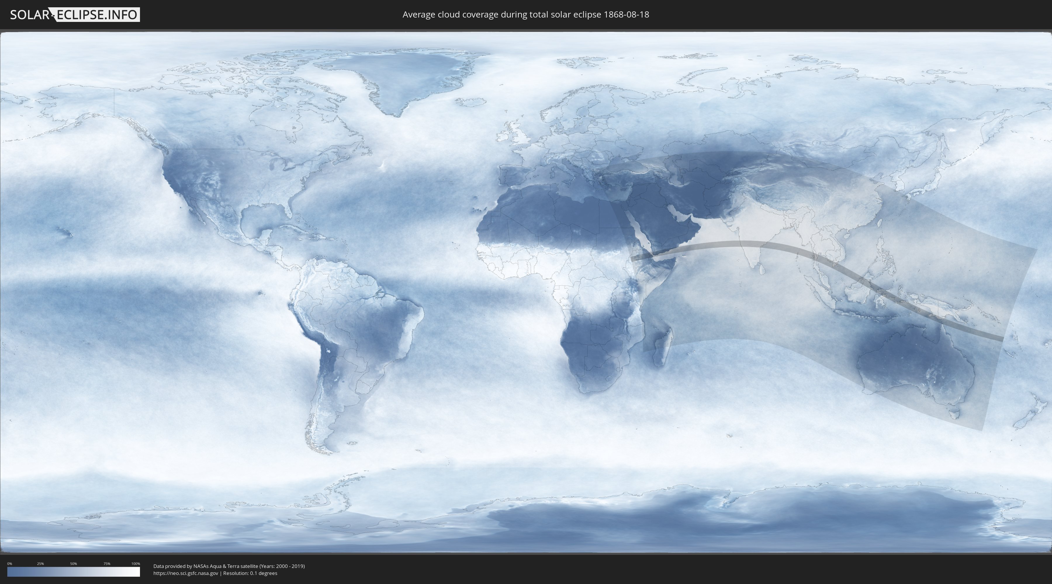
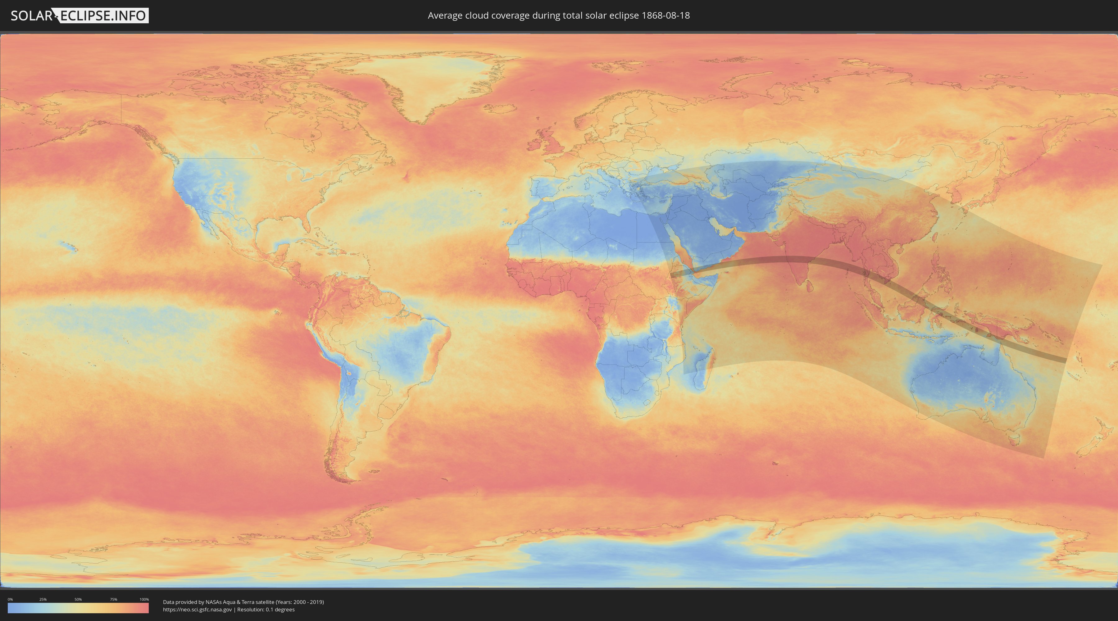
How will be the weather during the total solar eclipse on 08/18/1868?
Where is the best place to see the total solar eclipse of 08/18/1868?
The following maps show the average cloud coverage for the day of the total solar eclipse.
With the help of these maps, it is possible to find the place along the eclipse path, which has the best
chance of a cloudless sky.
Nevertheless, you should consider local circumstances and inform about the weather of your chosen
observation site.
The data is provided by NASAs satellites
AQUA and TERRA.
The cloud maps are averaged over a period of 19 years (2000 - 2019).
Detailed country maps
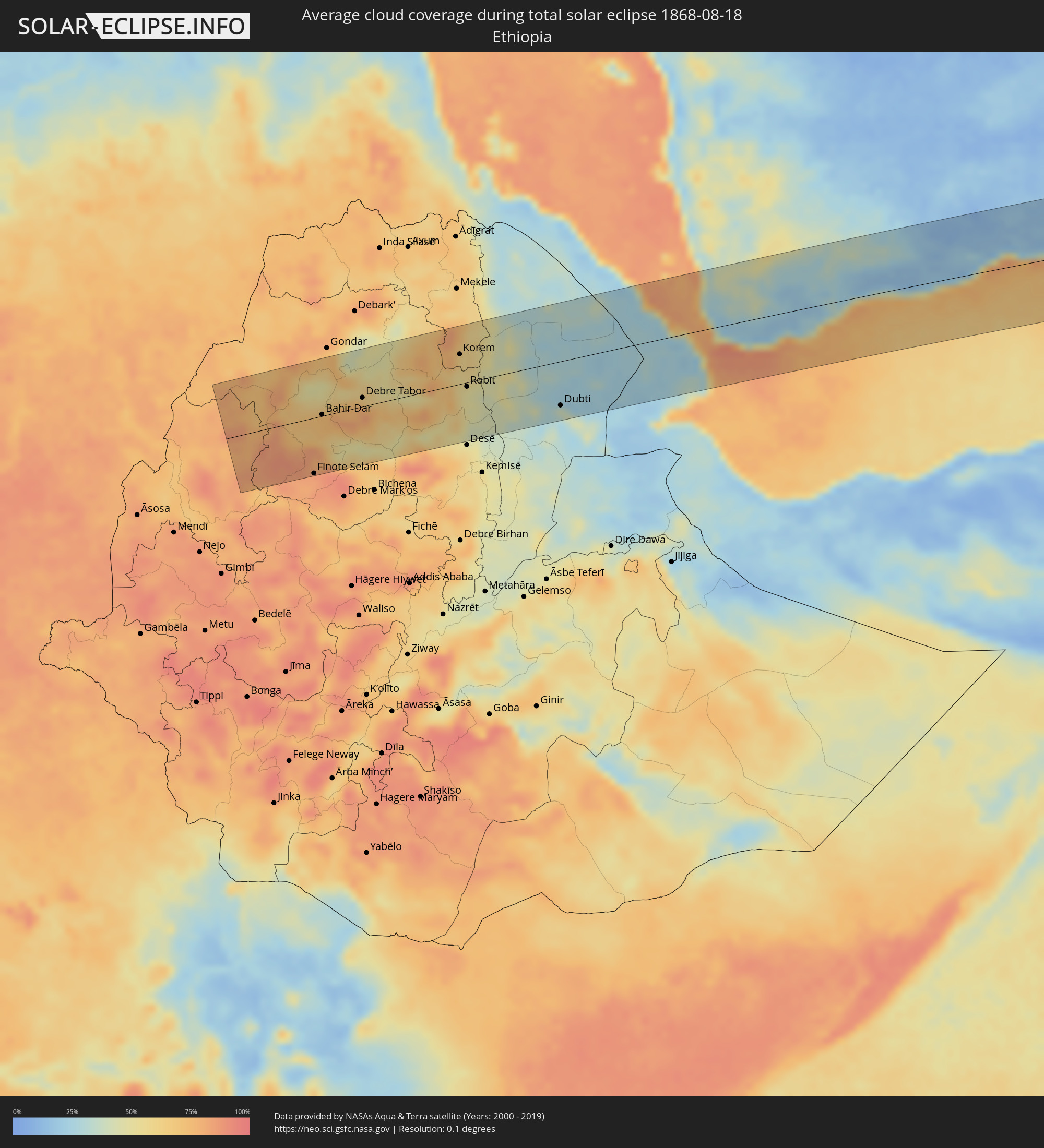 Ethiopia
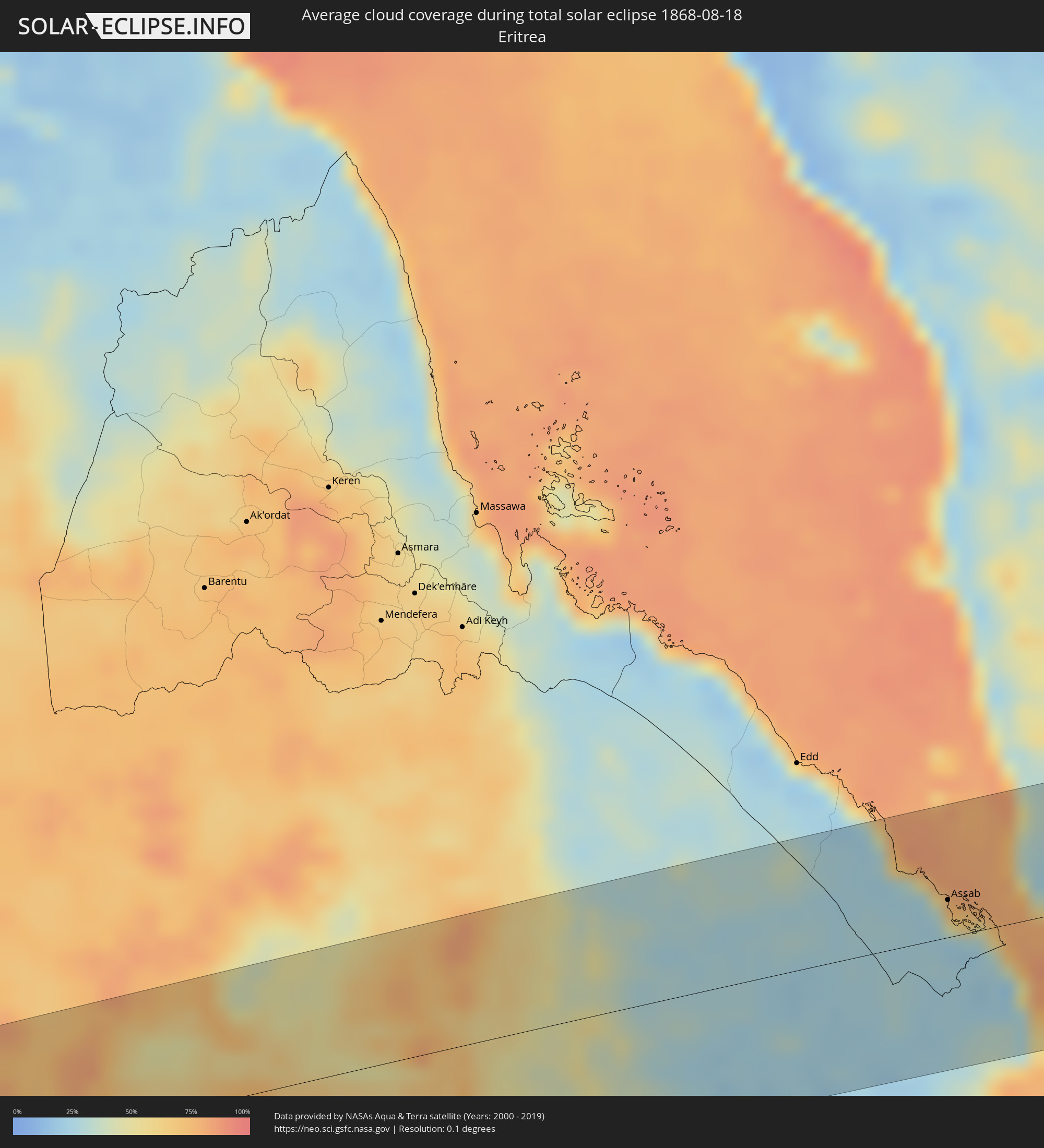 Eritrea
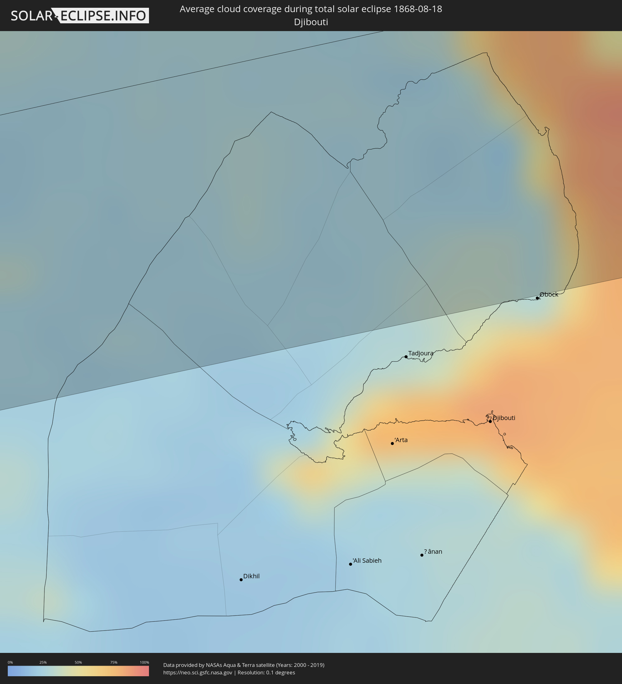 Djibouti
 Yemen
Yemen
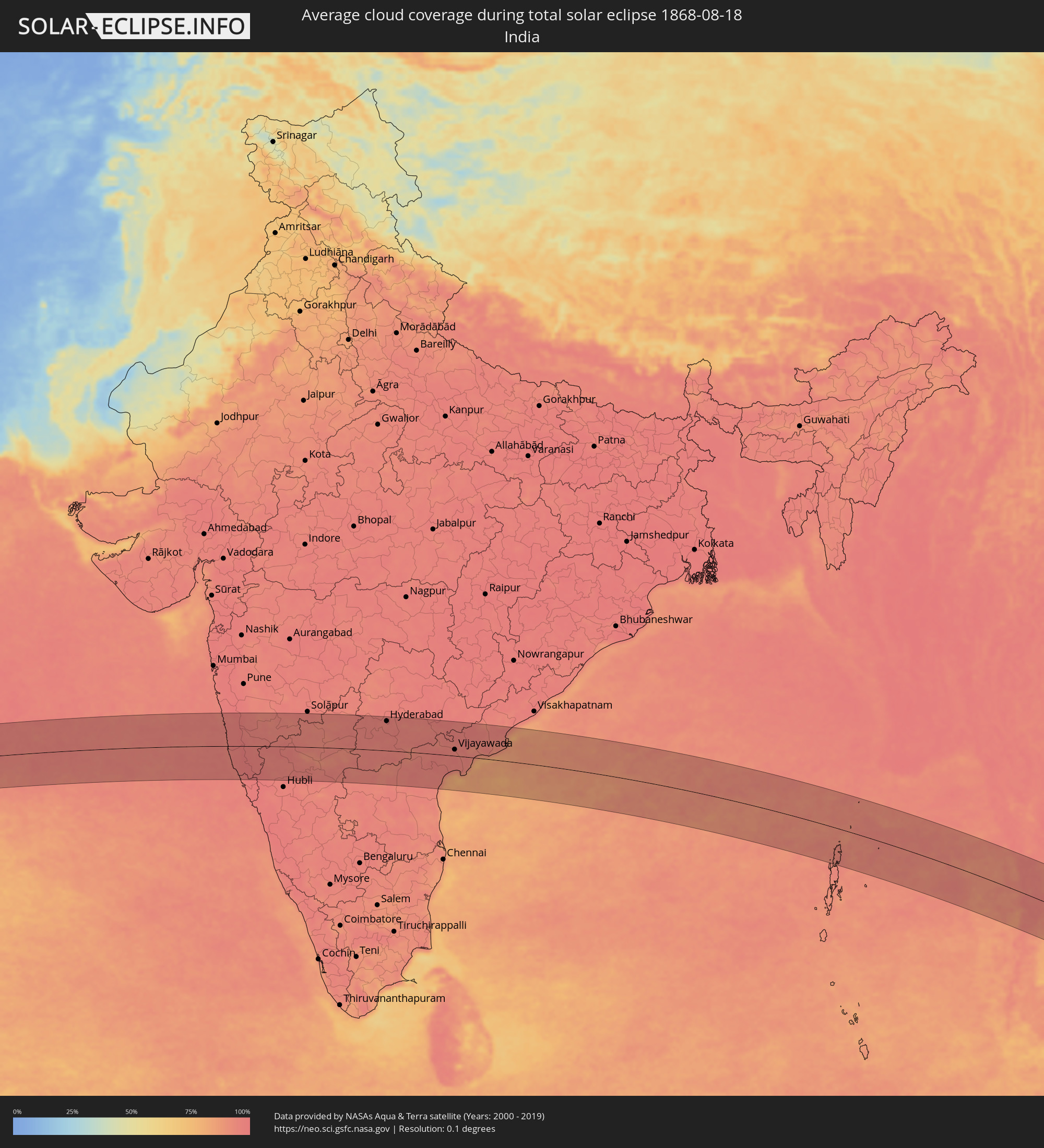 India
India
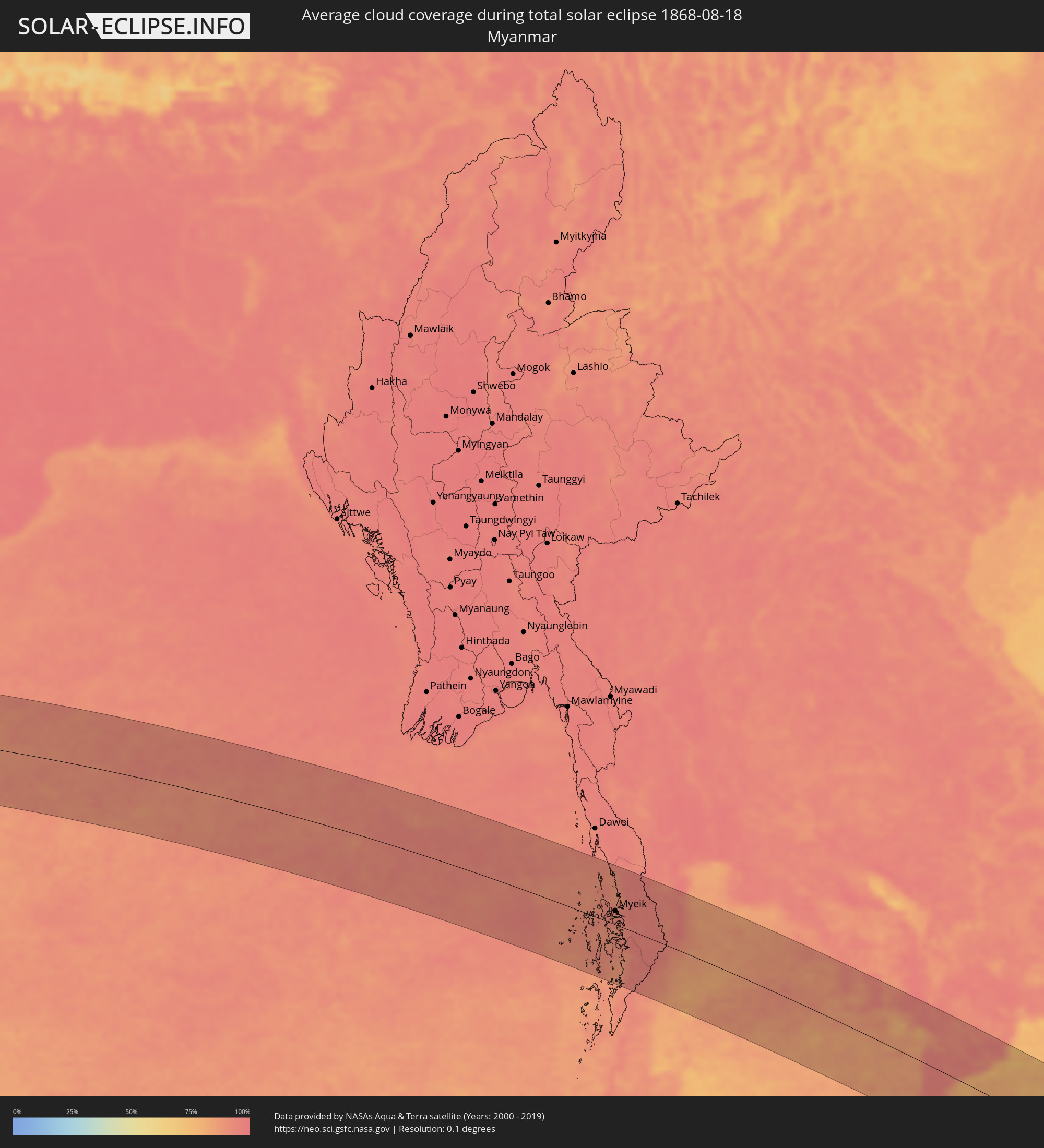 Myanmar
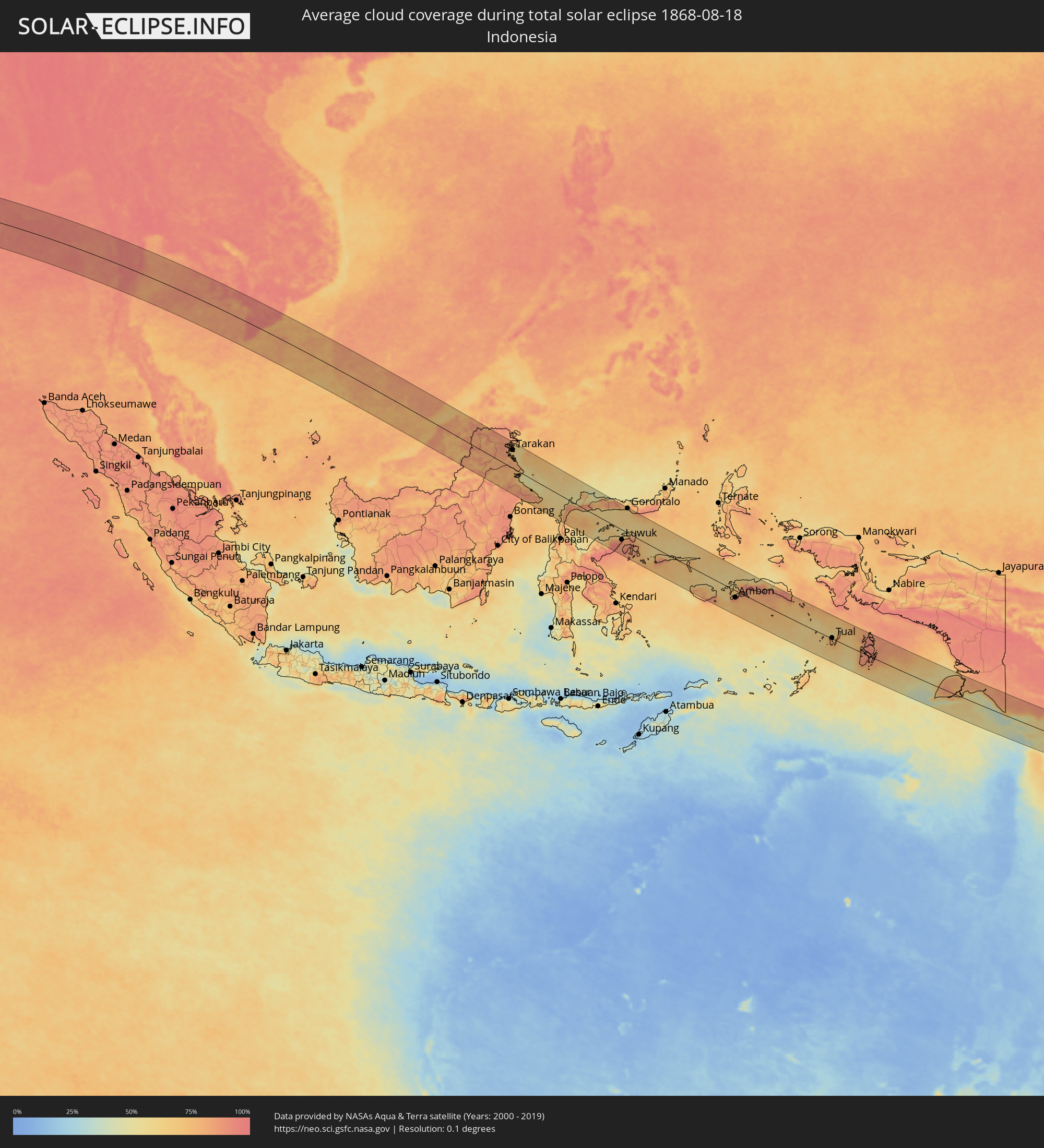 Indonesia
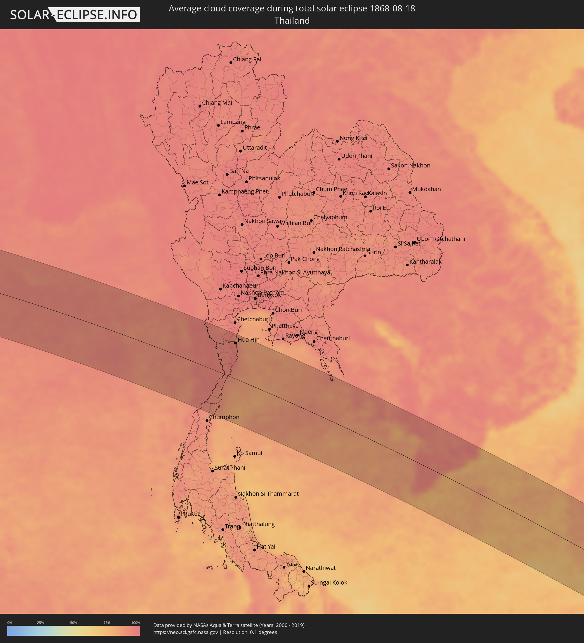 Thailand
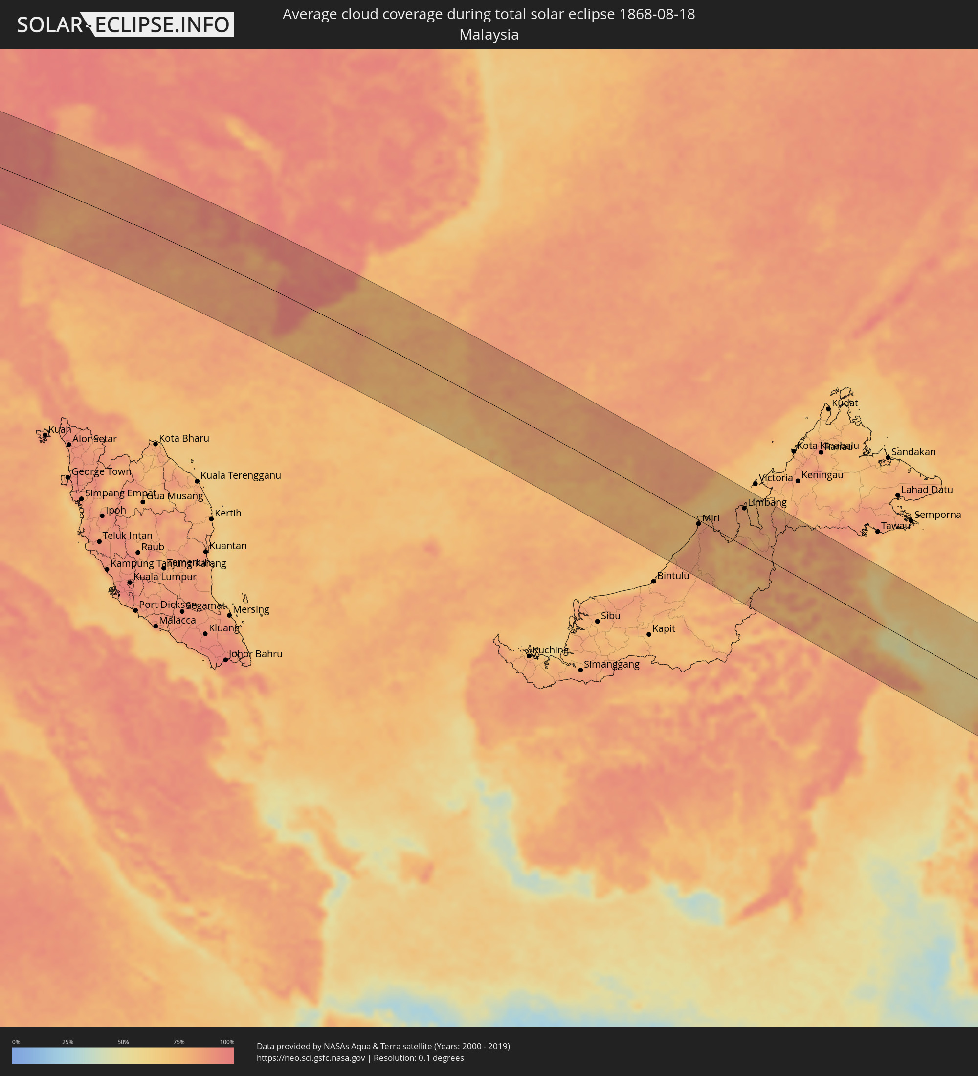 Malaysia
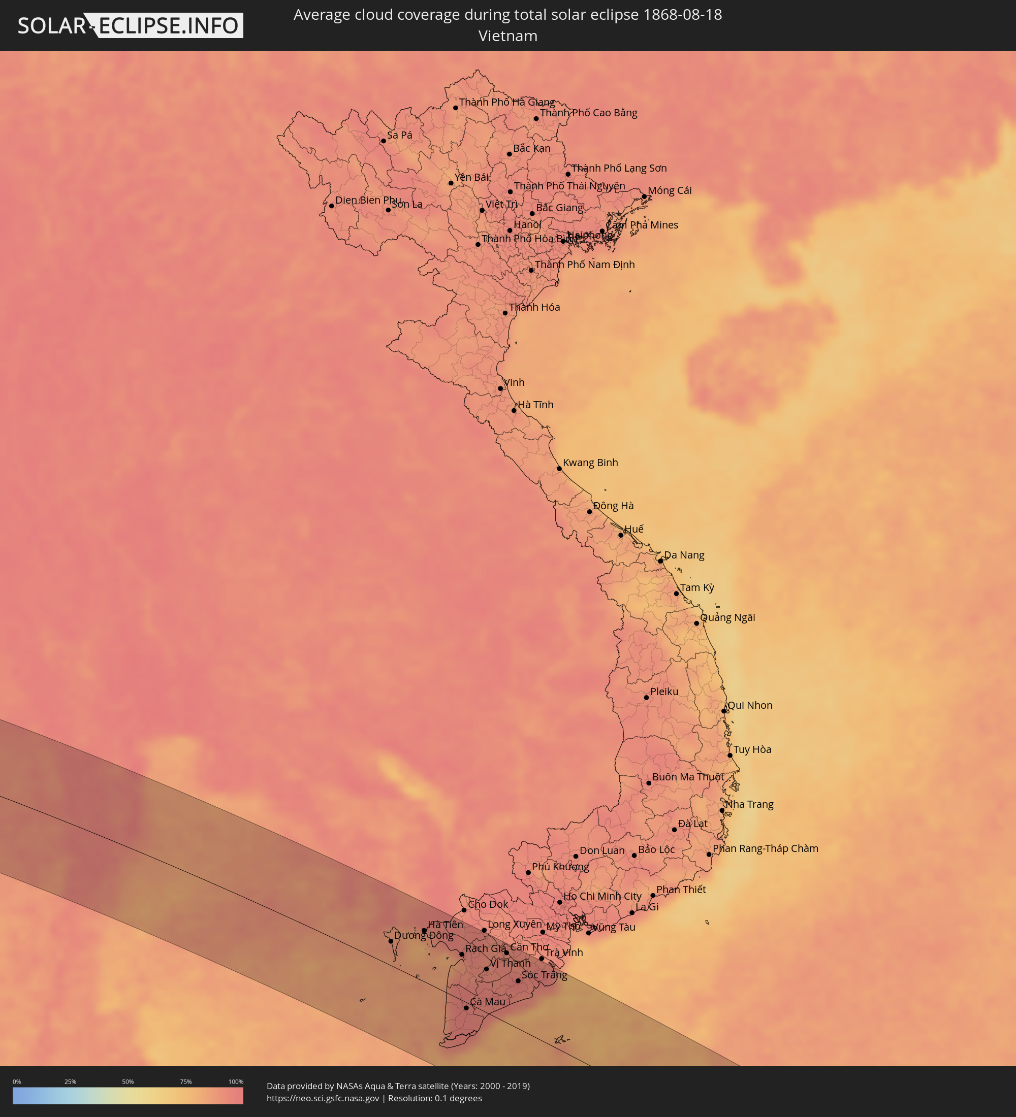 Vietnam
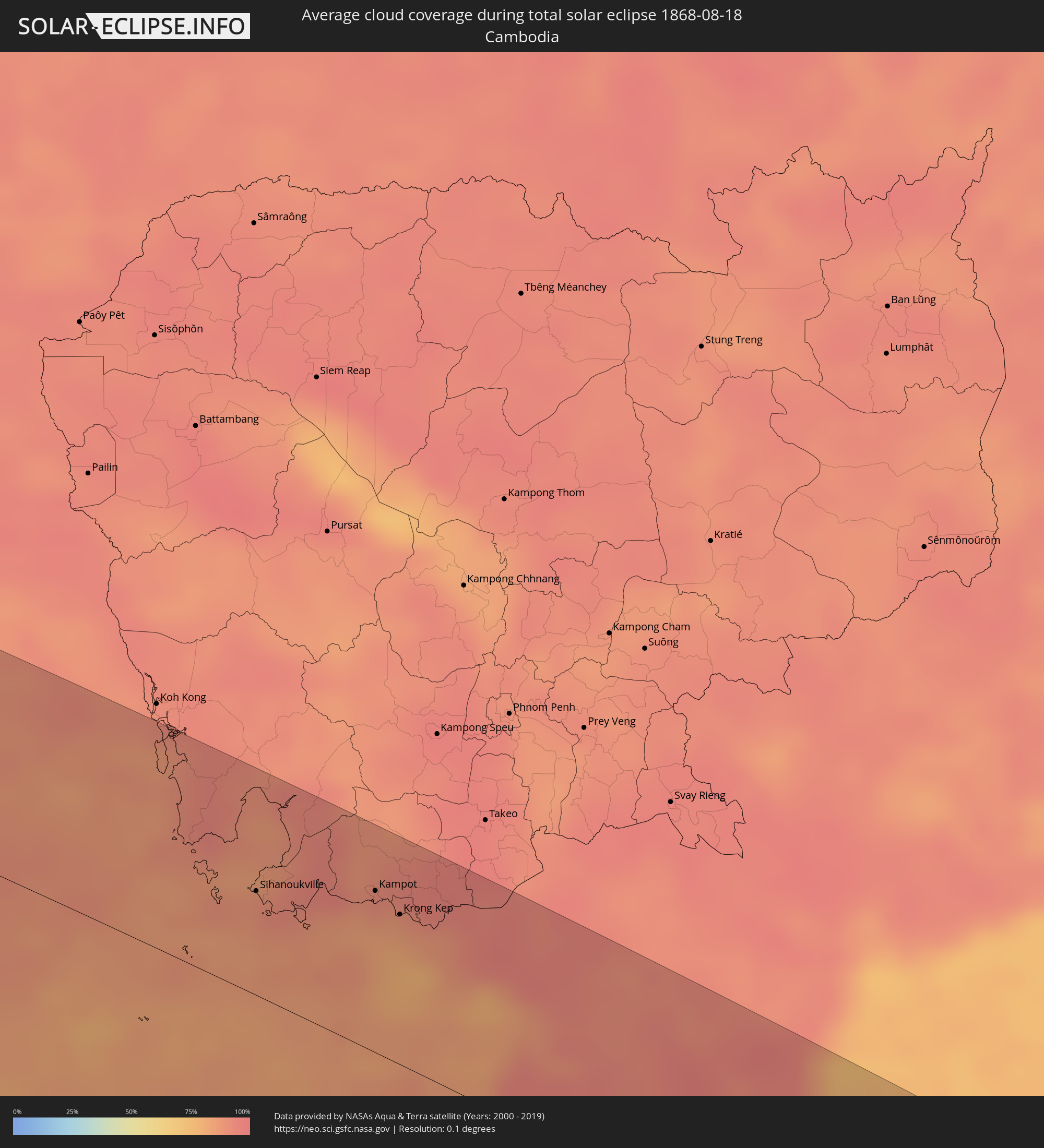 Cambodia
 Australia
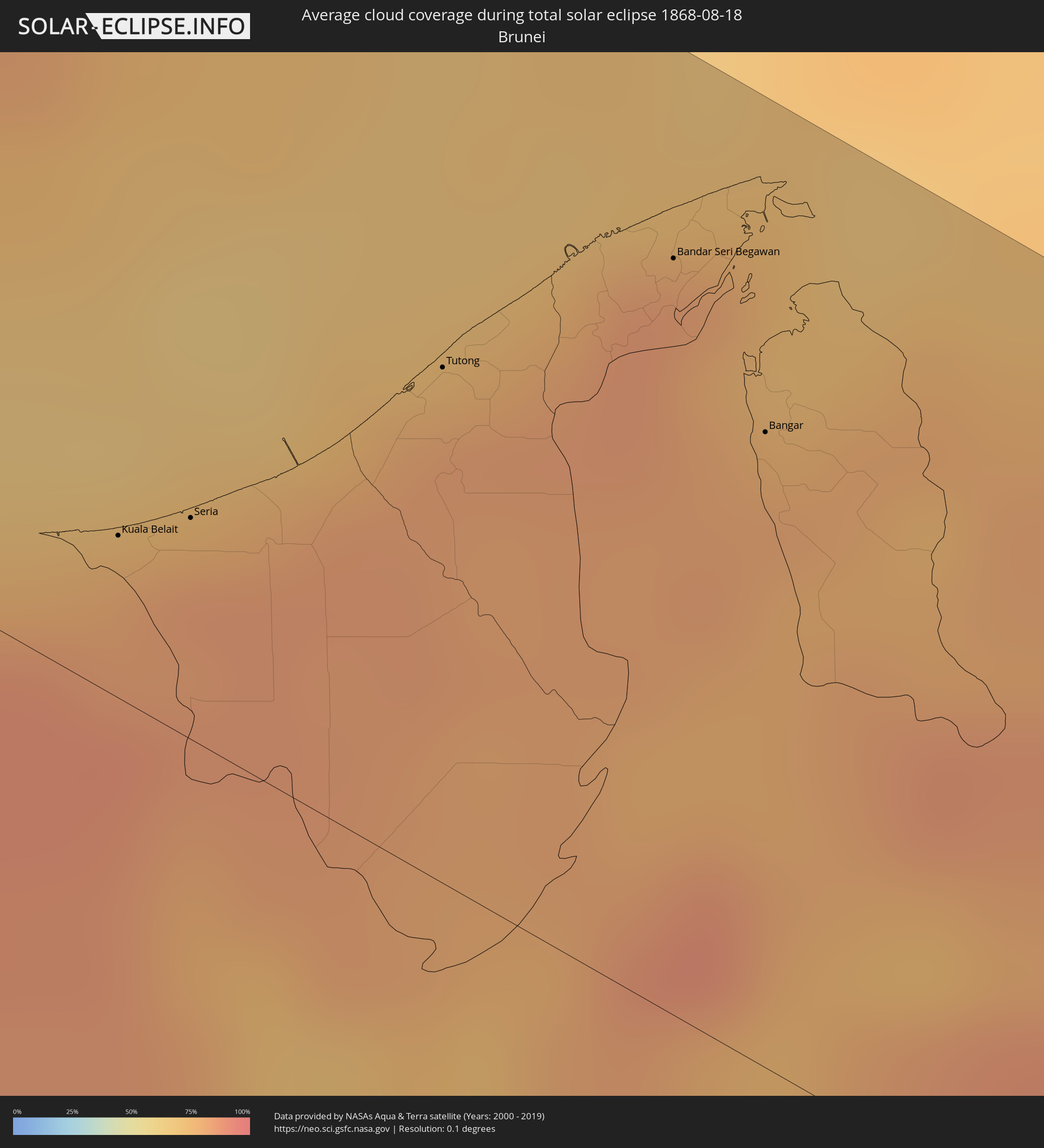 Brunei
 Papua New Guinea
Cities inside the path of the eclipse
The following table shows all locations with a population of more than 5,000 inside the eclipse path. Cities which have more than 100,000 inhabitants are marked bold. A click at the locations opens a detailed map.
| City | Type | Eclipse duration | Local time of max. eclipse | Distance to central line | Ø Cloud coverage |
|
Burē, Amhara
|
total | - | 05:56:40 UTC+02:27 | 87 km | 82% |
|
Finote Selam, Amhara
|
total | - | 05:56:40 UTC+02:27 | 92 km | 83% |
|
Bahir Dar, Amhara
|
total | - | 05:56:45 UTC+02:27 | 2 km | 72% |
|
Addiet Canna, Amhara
|
total | - | 05:56:43 UTC+02:27 | 36 km | 63% |
|
Werota, Amhara
|
total | - | 05:56:48 UTC+02:27 | 30 km | 70% |
|
Ādīs Zemen, Amhara
|
total | - | 05:56:50 UTC+02:27 | 49 km | 57% |
|
Debre Tabor, Amhara
|
total | - | 05:56:48 UTC+02:27 | 15 km | 73% |
|
Lalībela, Amhara
|
total | - | 05:56:53 UTC+02:27 | 9 km | 57% |
|
Korem, Tigray
|
total | - | 05:56:59 UTC+02:27 | 49 km | 67% |
|
Maych’ew, Tigray
|
total | - | 05:57:02 UTC+02:27 | 79 km | 76% |
|
Robīt, Amhara
|
total | - | 05:56:56 UTC+02:27 | 7 km | 51% |
|
Semera, Āfar
|
total | - | 05:57:04 UTC+02:27 | 64 km | 32% |
|
Dubti, Āfar
|
total | - | 05:57:05 UTC+02:27 | 72 km | 34% |
|
Assab, Southern Red Sea
|
total | - | 05:57:32 UTC+02:27 | 27 km | 35% |
|
Ta‘izz, Ta‘izz
|
total | - | 06:37:30 UTC+03:06 | 60 km | 39% |
|
Dhī as Sufāl, Ibb
|
total | - | 06:37:34 UTC+03:06 | 86 km | 43% |
|
Dhalie, Aḑ Ḑāli‘
|
total | - | 06:37:42 UTC+03:06 | 57 km | 27% |
|
Laḩij, Laḩij
|
total | - | 06:37:39 UTC+03:06 | 16 km | 26% |
|
Aden, Aden
|
total | - | 06:37:39 UTC+03:06 | 50 km | 70% |
|
Zinjibār, Abyan
|
total | - | 06:37:48 UTC+03:06 | 19 km | 68% |
|
Al Bayḑā’, Al Bayḑāʼ
|
total | - | 06:38:00 UTC+03:06 | 70 km | 31% |
|
Jawf al Maqbābah, Abyan
|
total | - | 06:38:03 UTC+03:06 | 48 km | 17% |
|
Al Mukallā, Muḩāfaz̧at Ḩaḑramawt
|
total | - | 06:39:25 UTC+03:06 | 56 km | 79% |
|
Kolhāpur, Maharashtra
|
total | - | 09:20:17 UTC+05:21 | 9 km | 96% |
|
Ichalkaranji, Maharashtra
|
total | - | 09:20:41 UTC+05:21 | 9 km | 97% |
|
Belgaum, Karnataka
|
total | - | 09:20:52 UTC+05:21 | 85 km | 98% |
|
Sāngli, Maharashtra
|
total | - | 09:20:51 UTC+05:21 | 27 km | 96% |
|
Bijapur, Karnataka
|
total | - | 09:22:54 UTC+05:21 | 26 km | 95% |
|
Gulbarga, Karnataka
|
total | - | 09:24:54 UTC+05:21 | 87 km | 93% |
|
Ādoni, Andhra Pradesh
|
total | - | 09:26:02 UTC+05:21 | 101 km | 94% |
|
Rāichūr, Karnataka
|
total | - | 09:26:04 UTC+05:21 | 36 km | 96% |
|
Hyderabad, Telangana
|
total | - | 09:27:59 UTC+05:21 | 101 km | 95% |
|
Nandyāl, Andhra Pradesh
|
total | - | 09:28:28 UTC+05:21 | 110 km | 95% |
|
Secunderabad, Telangana
|
total | - | 09:28:07 UTC+05:21 | 115 km | 96% |
|
Ongole, Andhra Pradesh
|
total | - | 09:31:40 UTC+05:21 | 96 km | 94% |
|
Khammam, Telangana
|
total | - | 09:31:23 UTC+05:21 | 99 km | 96% |
|
Guntur, Andhra Pradesh
|
total | - | 09:32:18 UTC+05:21 | 4 km | 96% |
|
Vijayawada, Andhra Pradesh
|
total | - | 09:32:38 UTC+05:21 | 21 km | 95% |
|
Ellore, Andhra Pradesh
|
total | - | 09:33:32 UTC+05:21 | 49 km | 95% |
|
Machilīpatnam, Andhra Pradesh
|
total | - | 09:33:47 UTC+05:21 | 9 km | 95% |
|
Rājahmundry, Andhra Pradesh
|
total | - | 09:34:53 UTC+05:21 | 88 km | 95% |
|
Kākināda, Andhra Pradesh
|
total | - | 09:35:53 UTC+05:21 | 89 km | 95% |
|
Myeik, Tanintharyi
|
total | - | 11:24:39 UTC+06:24 | 29 km | 92% |
|
Bang Saphan, Prachuap Khiri Khan
|
total | - | 11:45:53 UTC+06:42 | 61 km | 91% |
|
Prachuap Khiri Khan, Prachuap Khiri Khan
|
total | - | 11:45:55 UTC+06:42 | 13 km | 90% |
|
Kui Buri, Prachuap Khiri Khan
|
total | - | 11:45:48 UTC+06:42 | 43 km | 95% |
|
Sam Roi Yot, Prachuap Khiri Khan
|
total | - | 11:45:38 UTC+06:42 | 63 km | 96% |
|
Pran Buri, Prachuap Khiri Khan
|
total | - | 11:45:35 UTC+06:42 | 76 km | 95% |
|
Hua Hin, Prachuap Khiri Khan
|
total | - | 11:45:31 UTC+06:42 | 98 km | 91% |
|
Cha-am, Phetchaburi
|
total | - | 11:45:17 UTC+06:42 | 122 km | 91% |
|
Sihanoukville, Preah Sihanouk
|
total | - | 11:57:45 UTC+06:42 | 56 km | 88% |
|
Dương Đông, Kiến Giang
|
total | - | 12:24:02 UTC+07:06 | 37 km | 87% |
|
Kampot, Kampot
|
total | - | 11:59:31 UTC+06:42 | 87 km | 88% |
|
Krong Kep, Kep
|
total | - | 12:00:03 UTC+06:42 | 81 km | 83% |
|
Hà Tiên, Kiến Giang
|
total | - | 12:25:15 UTC+07:06 | 79 km | 85% |
|
Rạch Giá, Kiến Giang
|
total | - | 12:27:20 UTC+07:06 | 71 km | 88% |
|
Cà Mau, Cà Mau
|
total | - | 12:28:38 UTC+07:06 | 9 km | 95% |
|
Vị Thanh, Hau Giang
|
total | - | 12:28:41 UTC+07:06 | 67 km | 93% |
|
Thành phố Bạc Liêu, Bạc Liêu
|
total | - | 12:30:02 UTC+07:06 | 31 km | 94% |
|
Cần Thơ, Cần Thơ
|
total | - | 12:29:12 UTC+07:06 | 108 km | 94% |
|
Sóc Trăng, Sóc Trăng
|
total | - | 12:30:16 UTC+07:06 | 73 km | 94% |
|
Miri, Sarawak
|
total | - | 13:12:13 UTC+07:21 | 8 km | 84% |
|
Kuala Belait, Belait
|
total | - | 13:30:50 UTC+07:39 | 20 km | 79% |
|
Seria, Belait
|
total | - | 13:31:01 UTC+07:39 | 28 km | 83% |
|
Tutong, Tutong
|
total | - | 13:31:30 UTC+07:39 | 64 km | 82% |
|
Bandar Seri Begawan, Brunei and Muara
|
total | - | 13:31:59 UTC+07:39 | 94 km | 85% |
|
Limbang, Sarawak
|
total | - | 13:14:01 UTC+07:21 | 79 km | 80% |
|
Bangar, Temburong
|
total | - | 13:32:33 UTC+07:39 | 79 km | 80% |
|
Sembakung, East Kalimantan
|
total | - | 13:56:28 UTC+07:57 | 113 km | 83% |
|
Tanjung Selor, North Kalimantan
|
total | - | 13:58:00 UTC+07:57 | 25 km | 82% |
|
Tarakan, North Kalimantan
|
total | - | 13:57:51 UTC+07:57 | 83 km | 65% |
|
Luwuk, Central Sulawesi
|
total | - | 14:13:06 UTC+07:57 | 46 km | 84% |
|
Gorontalo, Gorontalo
|
total | - | 14:11:54 UTC+07:57 | 114 km | 62% |
|
Ambon, Maluku
|
total | - | 15:49:46 UTC+09:22 | 32 km | 85% |
|
Amahai, Maluku
|
total | - | 15:50:29 UTC+09:22 | 40 km | 80% |
|
Tual, Maluku
|
total | - | 15:57:27 UTC+09:22 | 3 km | 66% |