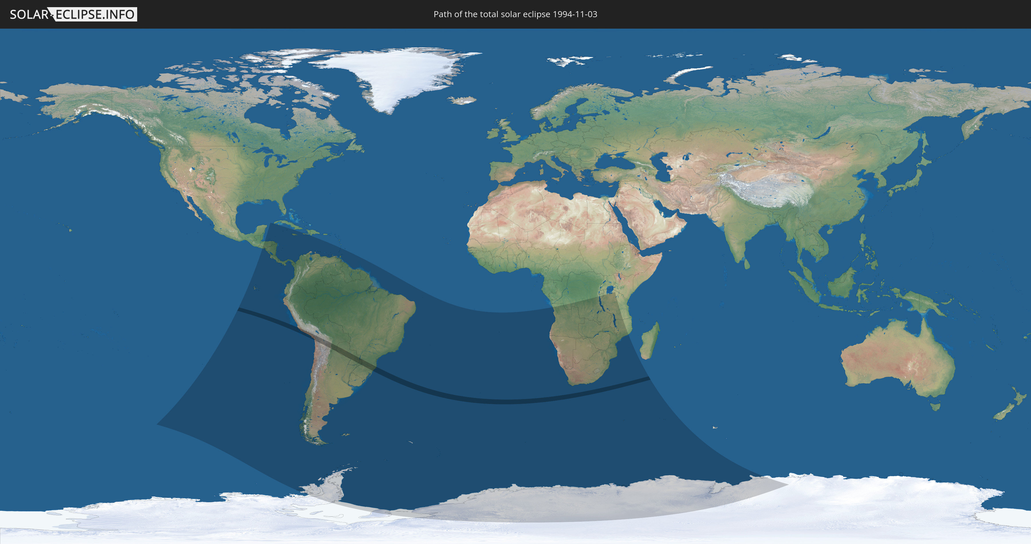
Total solar eclipse of 11/03/1994
Wo kann man die Sonnenfinsternis vom 11/03/1994 sehen?
Die Sonnenfinsternis am 11/03/1994 kann man in 47 Ländern als partielle Sonnenfinsternis beobachten.
Der Finsternispfad verläuft durch 7 Länder. Nur in diesen Ländern ist sie als total Sonnenfinsternis zu sehen.
In den folgenden Ländern ist die Sonnenfinsternis total zu sehen
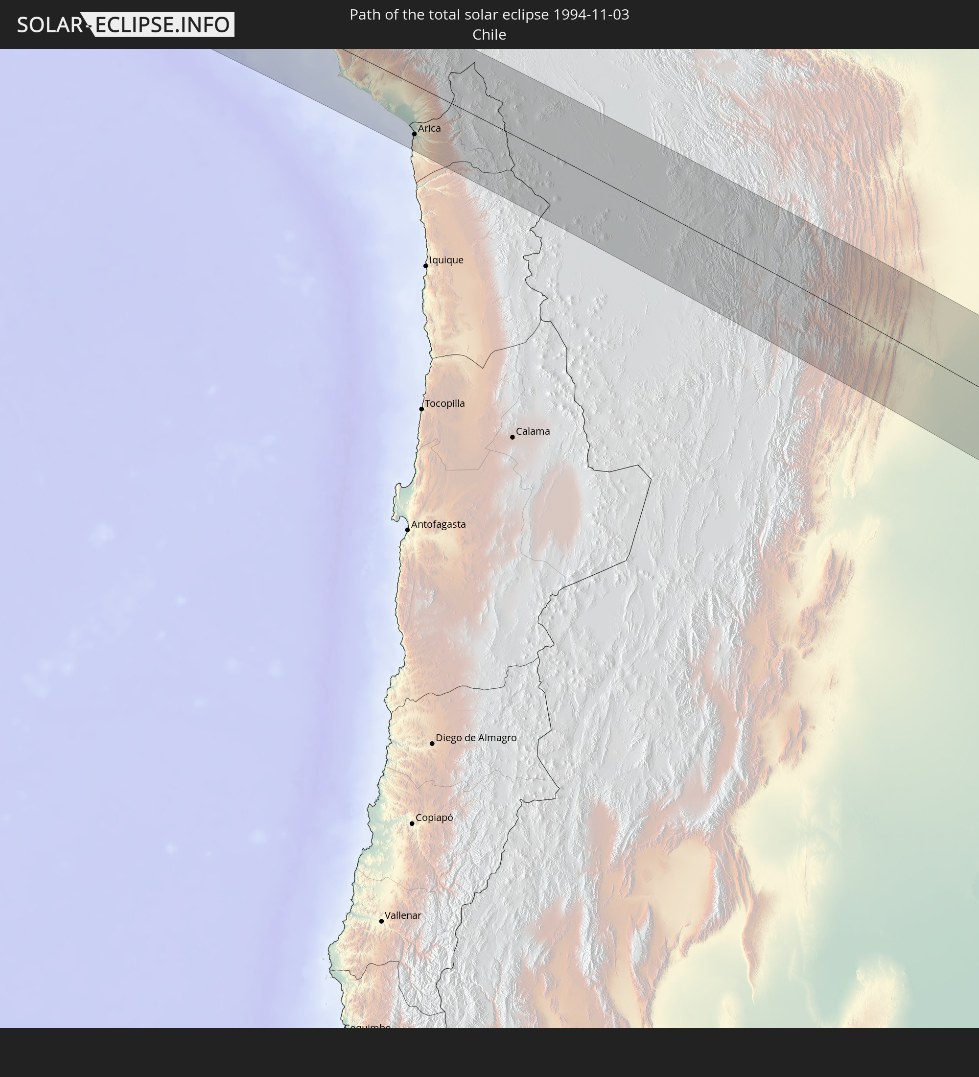 Chile
Chile
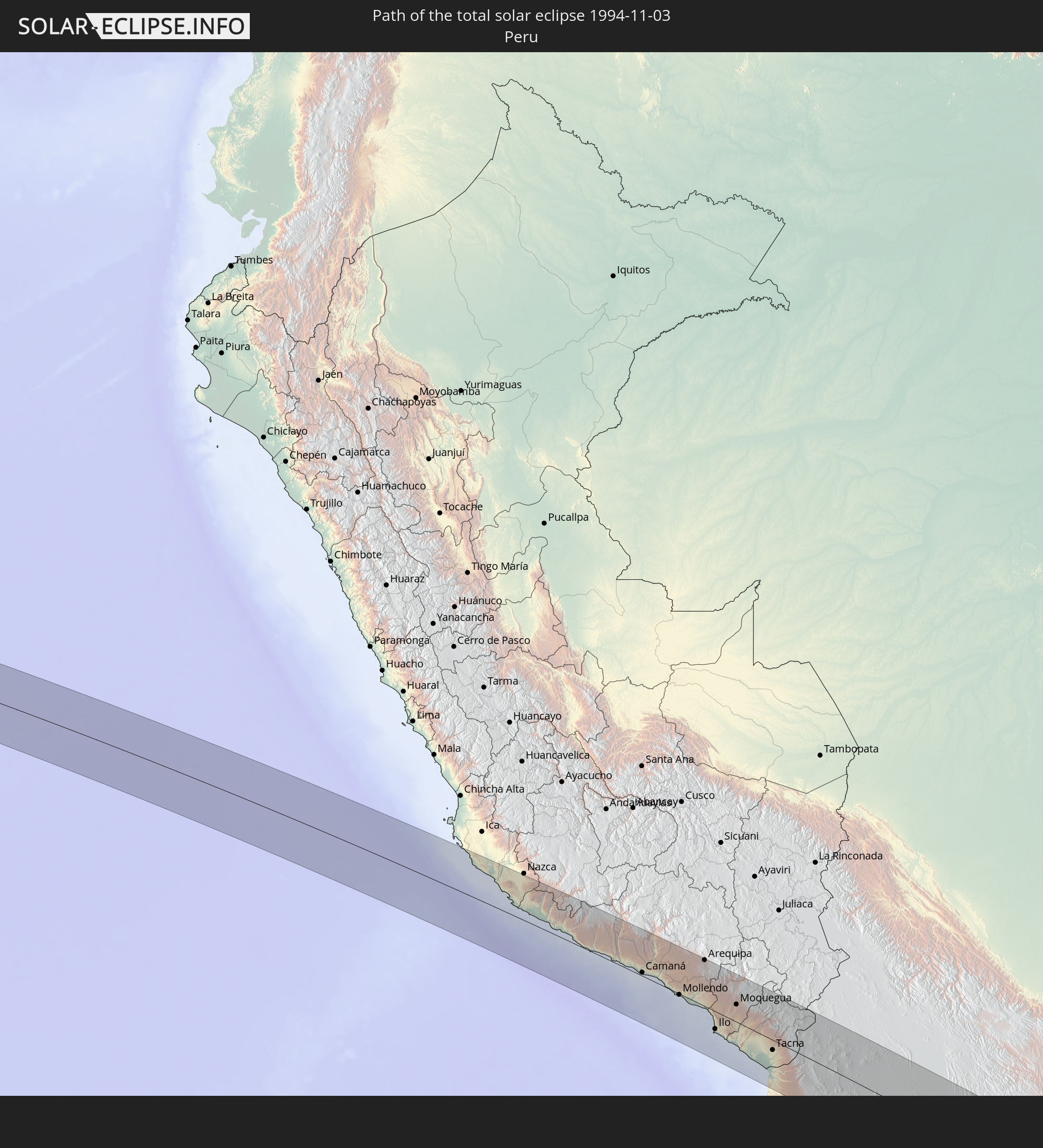 Peru
Peru
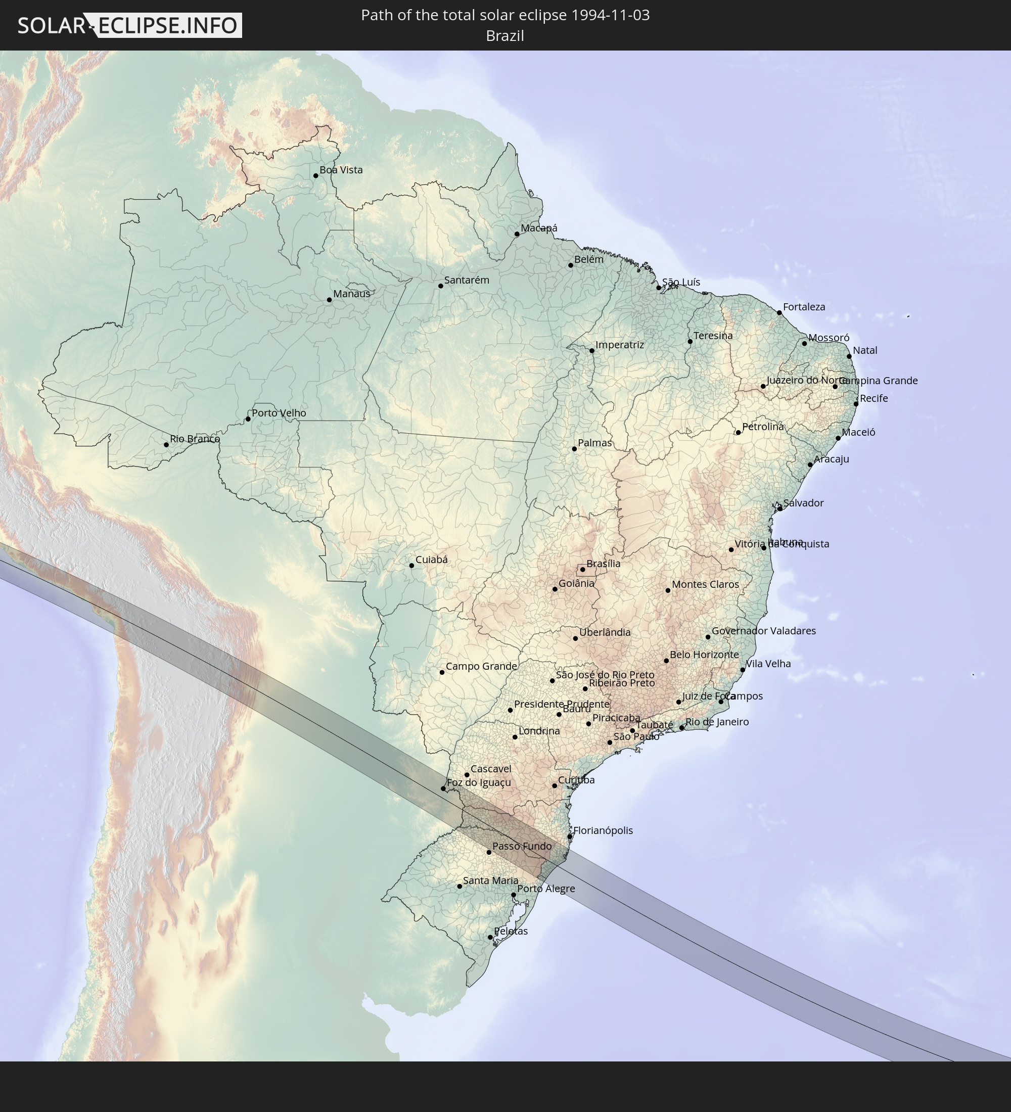 Brazil
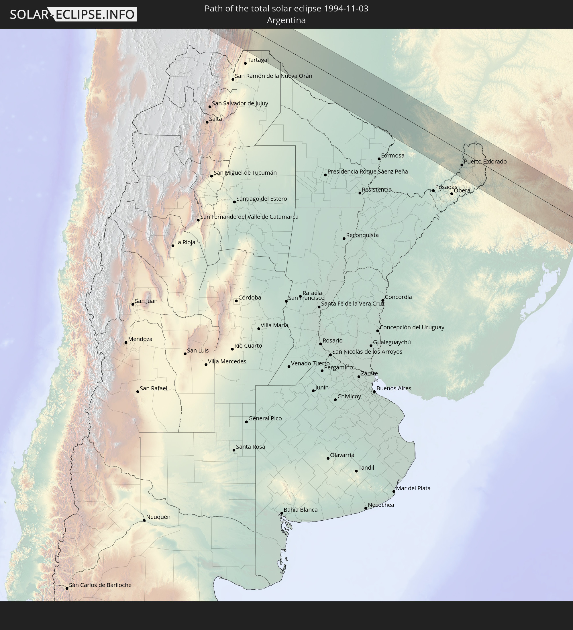 Argentina
 Bolivia
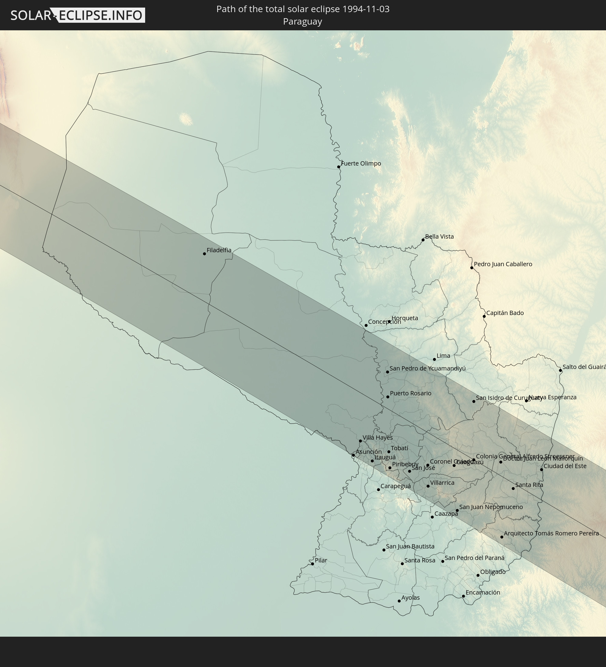 Paraguay
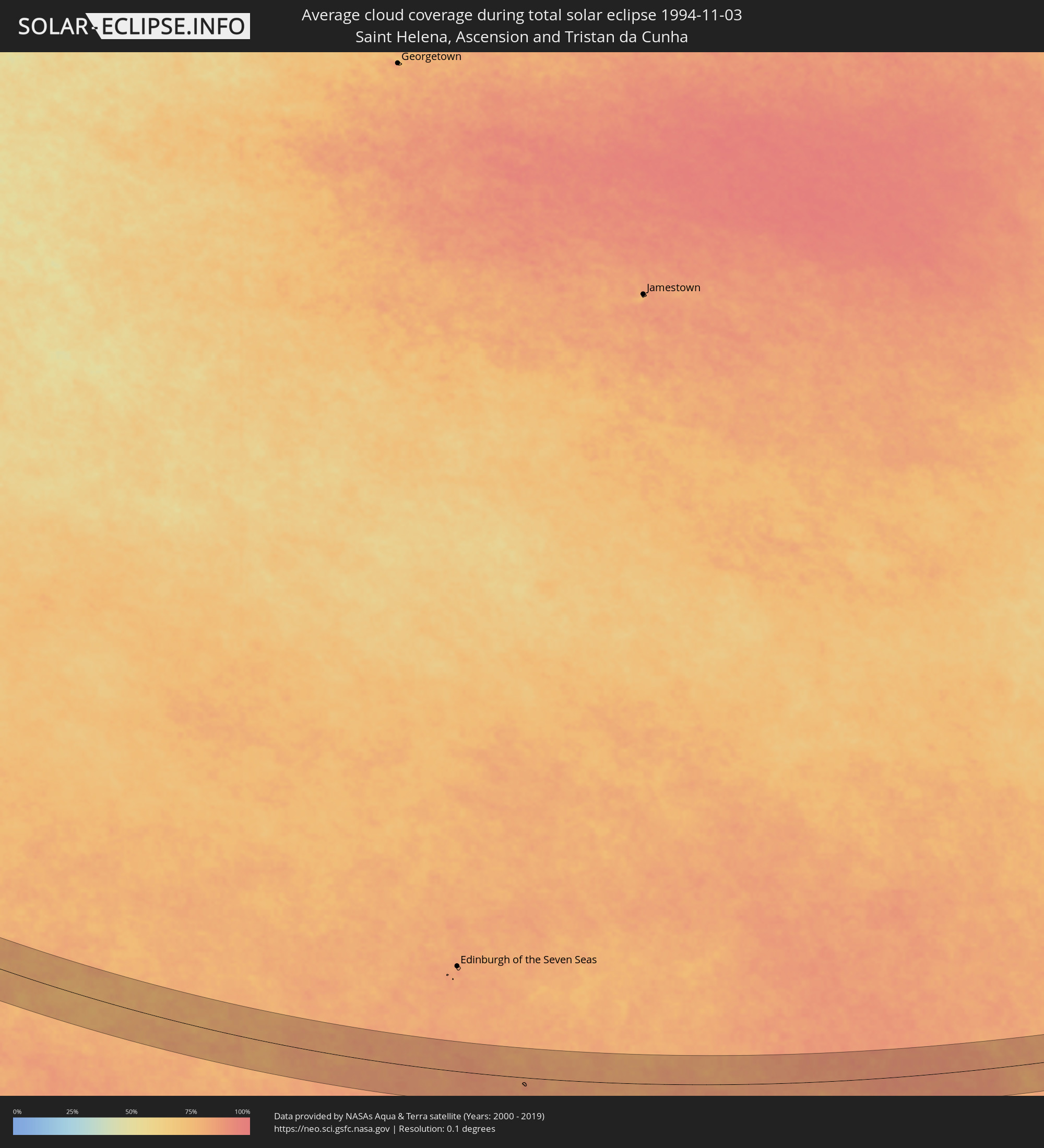
 Saint Helena, Ascension and Tristan da Cunha
In den folgenden Ländern ist die Sonnenfinsternis partiell zu sehen
 Antarctica
 United States Minor Outlying Islands
 Chile
Chile
 Ecuador
 El Salvador
 Honduras
 Nicaragua
 Costa Rica
 Cuba
Cuba
 Panama
 Colombia
 Cayman Islands
 Peru
Peru
 Jamaica
 Haiti
Haiti
 Brazil
 Argentina
 Venezuela
 Dominican Republic
 Aruba
Aruba
 Bolivia
 Paraguay
 Trinidad and Tobago
 Grenada
 Saint Vincent and the Grenadines
 Falkland Islands
 Guyana
 Uruguay
 Suriname
 French Guiana
 South Georgia and the South Sandwich Islands
 Saint Helena, Ascension and Tristan da Cunha
 Bouvet Island
 Angola
 Namibia
 Democratic Republic of the Congo
 South Africa
 Botswana
 Zambia
 Zimbabwe
 Lesotho
 Burundi
 Tanzania
 Mozambique
 Swaziland
 Malawi
 French Southern and Antarctic Lands
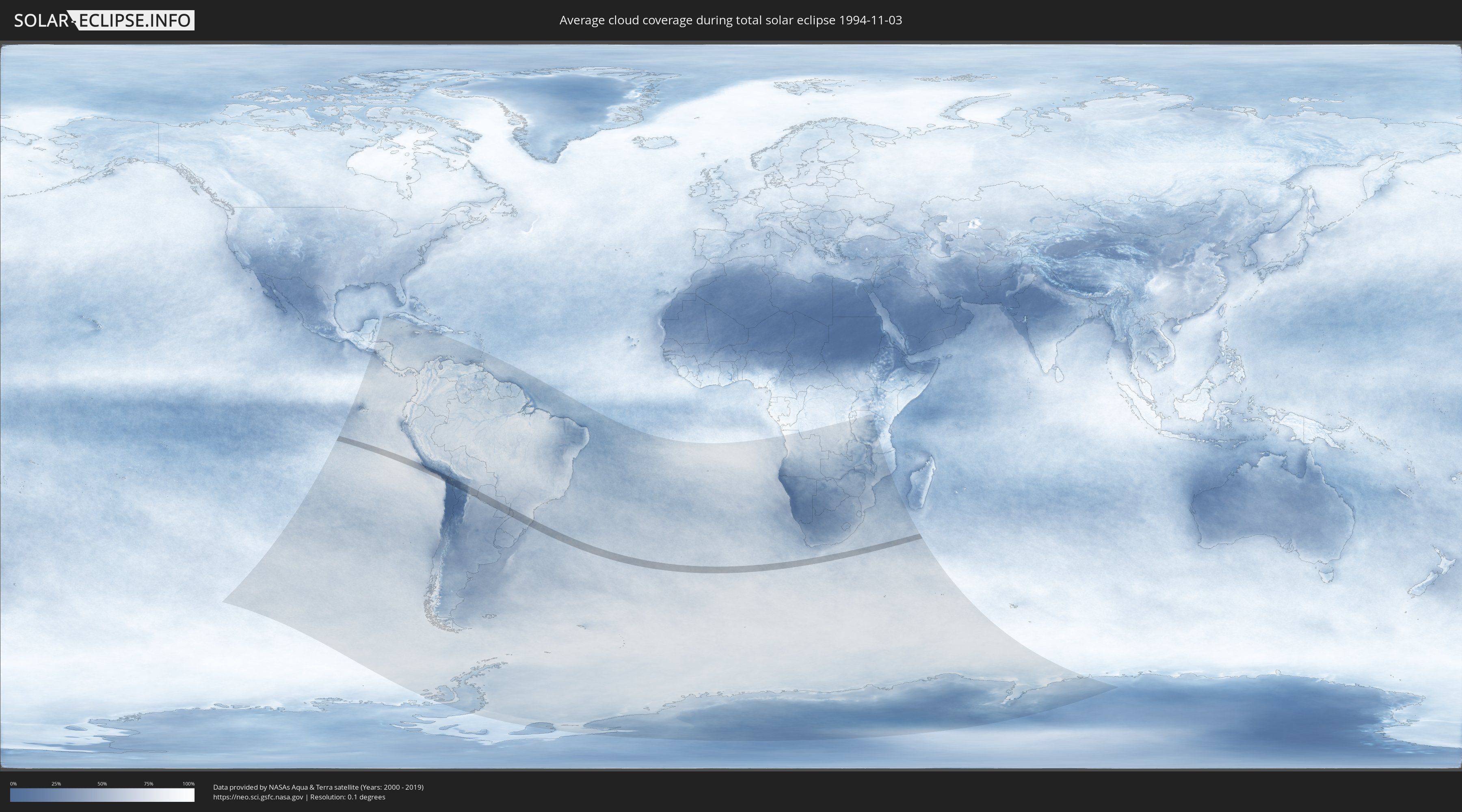
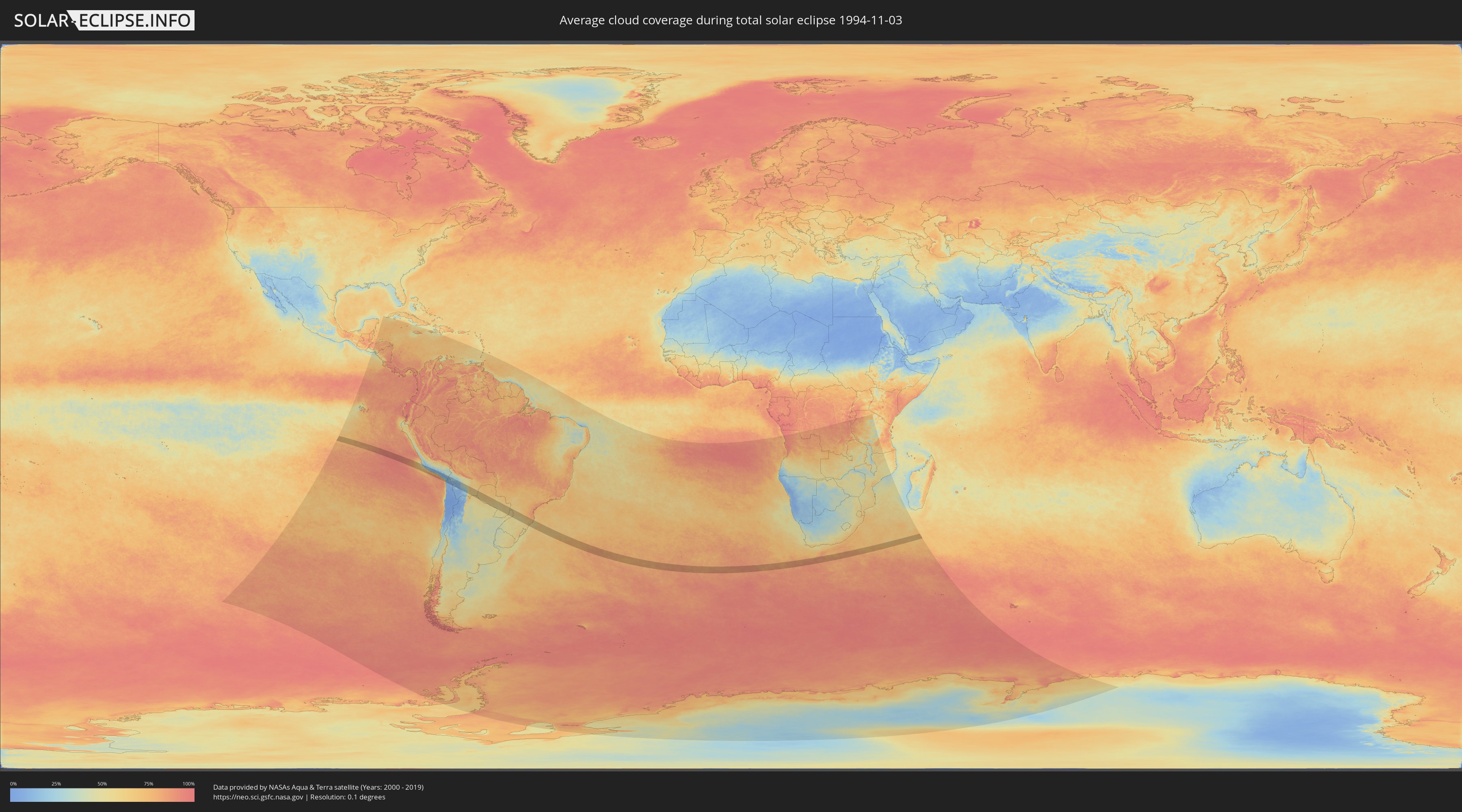
How will be the weather during the total solar eclipse on 11/03/1994?
Where is the best place to see the total solar eclipse of 11/03/1994?
The following maps show the average cloud coverage for the day of the total solar eclipse.
With the help of these maps, it is possible to find the place along the eclipse path, which has the best
chance of a cloudless sky.
Nevertheless, you should consider local circumstances and inform about the weather of your chosen
observation site.
The data is provided by NASAs satellites
AQUA and TERRA.
The cloud maps are averaged over a period of 19 years (2000 - 2019).
Detailed country maps
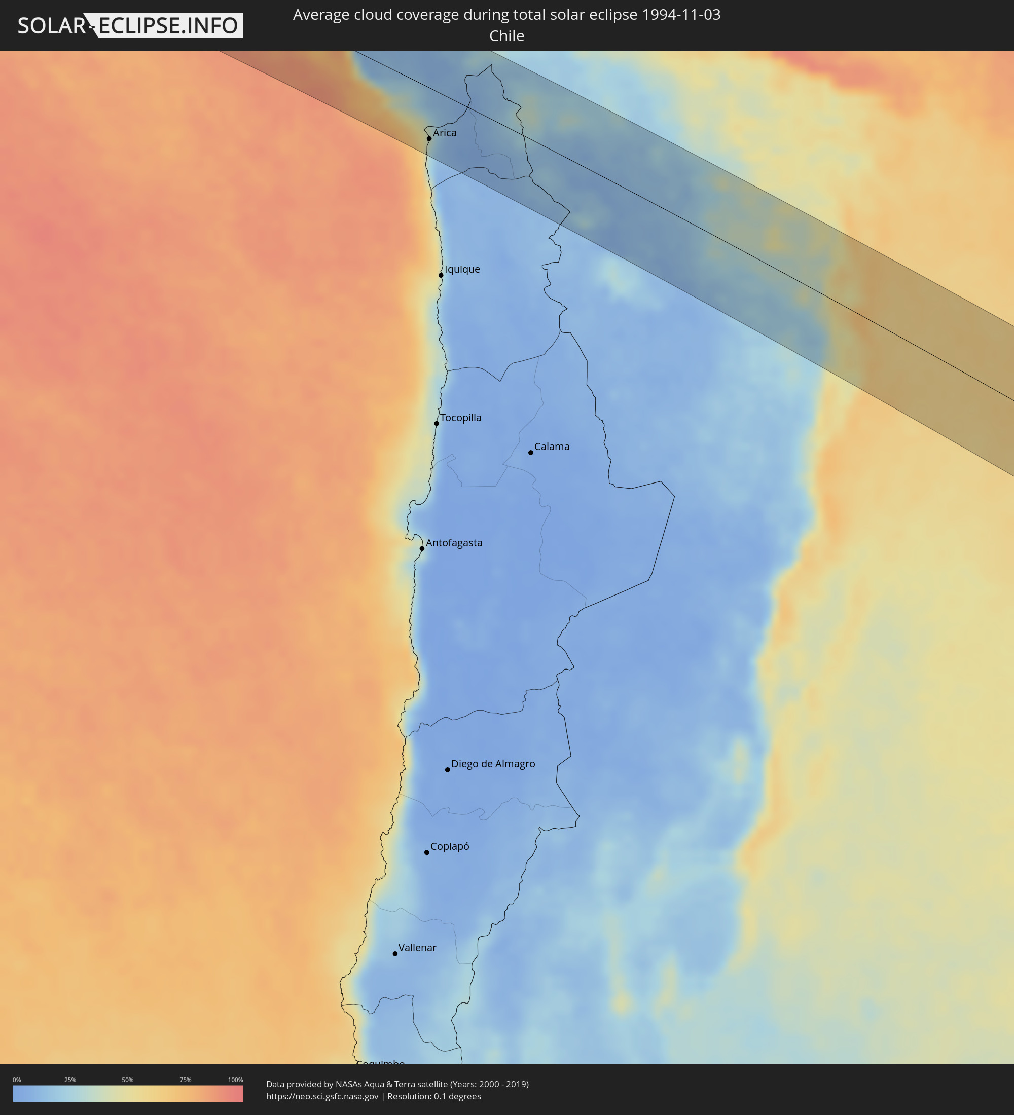 Chile
Chile
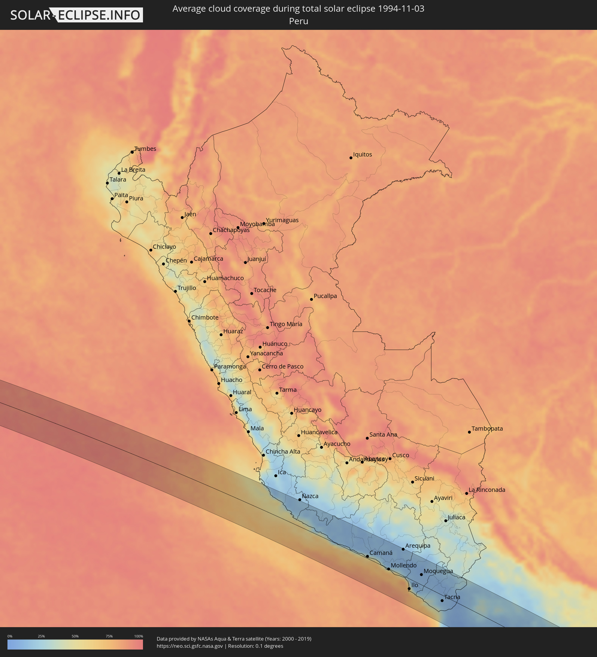 Peru
Peru
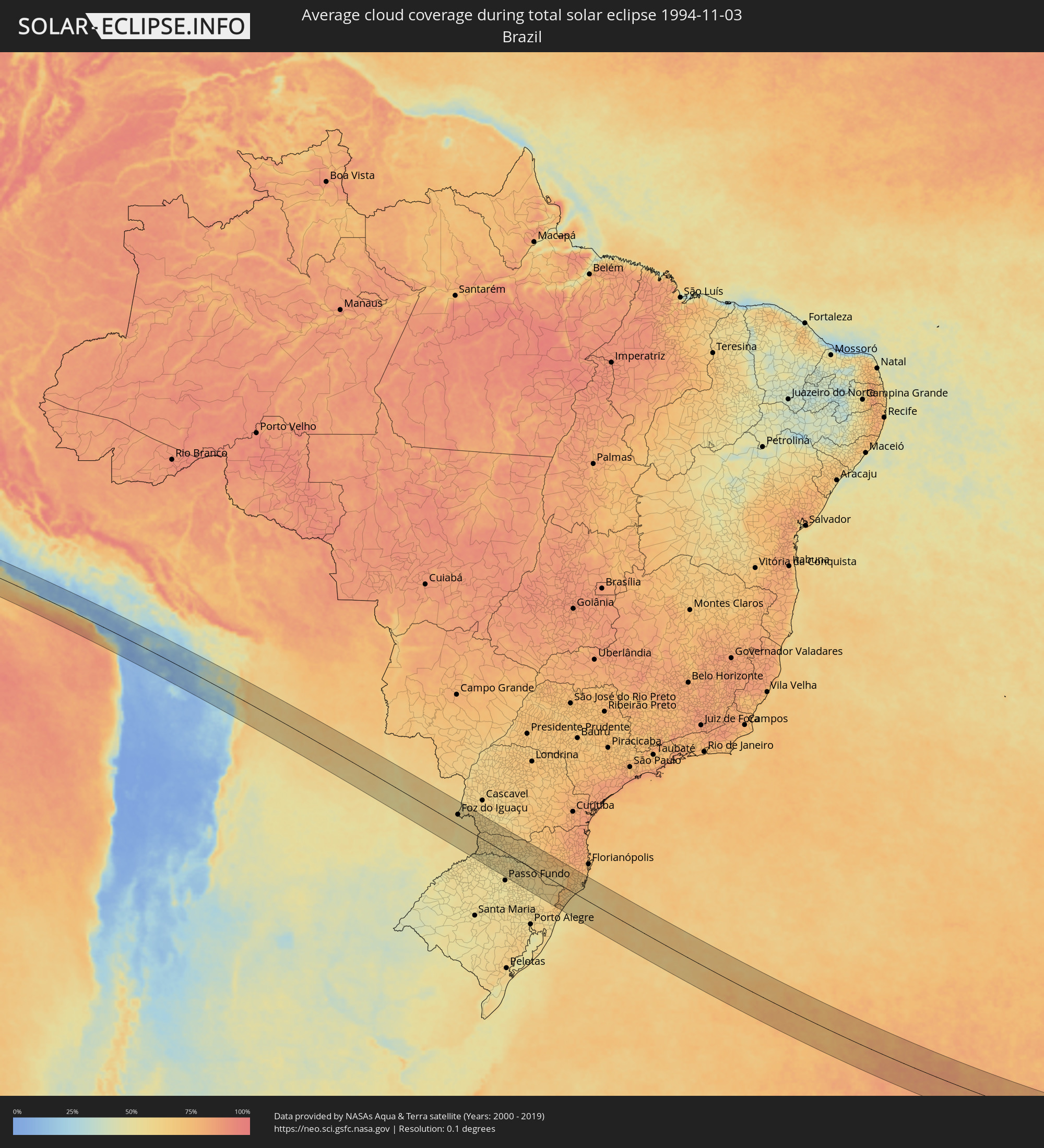 Brazil
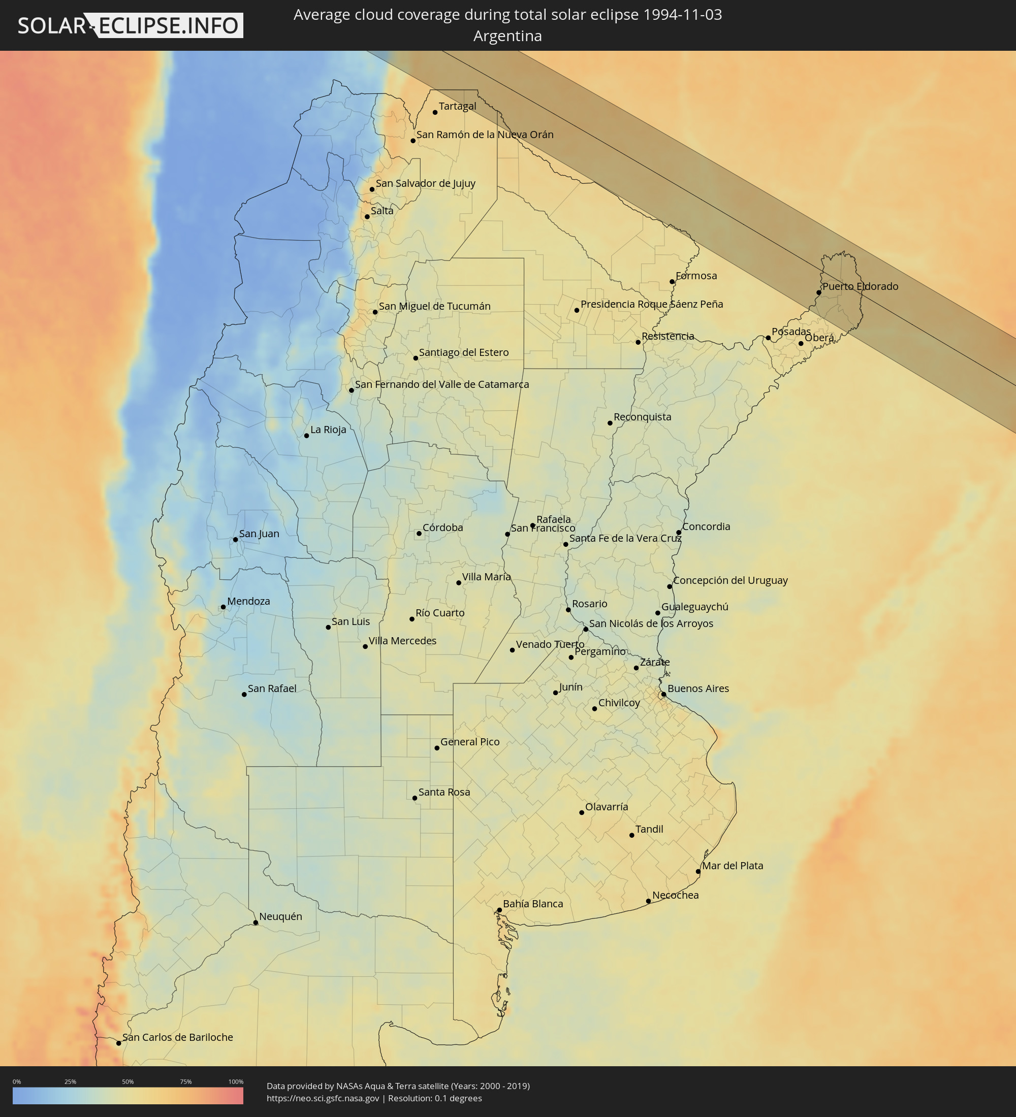 Argentina
 Bolivia
 Paraguay
 Saint Helena, Ascension and Tristan da Cunha
Cities inside the path of the eclipse
The following table shows all locations with a population of more than 5,000 inside the eclipse path. Cities which have more than 100,000 inhabitants are marked bold. A click at the locations opens a detailed map.
| City | Type | Eclipse duration | Local time of max. eclipse | Distance to central line | Ø Cloud coverage |
|
Minas de Marcona, Ica
|
total | - | 07:12:35 UTC-05:00 | 39 km | 25% |
|
Camaná, Arequipa
|
total | - | 07:15:40 UTC-05:00 | 6 km | 64% |
|
Mollendo, Arequipa
|
total | - | 07:16:37 UTC-05:00 | 2 km | 70% |
|
Punta de Bombón, Arequipa
|
total | - | 07:16:57 UTC-05:00 | 6 km | 72% |
|
Cocachacra, Arequipa
|
total | - | 07:16:52 UTC-05:00 | 4 km | 68% |
|
Arequipa, Arequipa
|
total | - | 07:16:08 UTC-05:00 | 83 km | 15% |
|
Ilo, Moquegua
|
total | - | 07:17:51 UTC-05:00 | 32 km | 55% |
|
Pacocha, Moquegua
|
total | - | 07:17:47 UTC-05:00 | 26 km | 55% |
|
Moquegua, Moquegua
|
total | - | 07:17:34 UTC-05:00 | 31 km | 12% |
|
Torata, Moquegua
|
total | - | 07:17:28 UTC-05:00 | 48 km | 11% |
|
Ilabaya, Tacna
|
total | - | 07:18:09 UTC-05:00 | 29 km | 11% |
|
Arica, Arica y Parinacota
|
total | - | 09:19:41 UTC-03:00 | 66 km | 31% |
|
Tacna, Tacna
|
total | - | 07:19:07 UTC-05:00 | 18 km | 21% |
|
Colchani, Potosí
|
total | - | 08:24:56 UTC-04:00 | 82 km | 8% |
|
Challapata, Oruro
|
total | - | 08:23:08 UTC-04:00 | 63 km | 18% |
|
Potosí, Potosí
|
total | - | 08:25:00 UTC-04:00 | 47 km | 37% |
|
Yacuiba, Tarija
|
total | - | 08:30:33 UTC-04:00 | 87 km | 59% |
|
Villamontes, Tarija
|
total | - | 08:29:40 UTC-04:00 | 3 km | 61% |
|
Filadelfia, Boquerón
|
total | - | 09:35:09 UTC-03:00 | 68 km | 64% |
|
Colonia Menno, Boquerón
|
total | - | 09:35:28 UTC-03:00 | 76 km | 64% |
|
Nanawa, Presidente Hayes
|
total | - | 09:42:39 UTC-03:00 | 92 km | 51% |
|
Asunción, Asunción
|
total | - | 09:42:45 UTC-03:00 | 93 km | 54% |
|
Benjamín Aceval, Presidente Hayes
|
total | - | 09:42:19 UTC-03:00 | 58 km | 52% |
|
Colonia Mariano Roque Alonso, Central
|
total | - | 09:42:39 UTC-03:00 | 76 km | 54% |
|
Villa Hayes, Presidente Hayes
|
total | - | 09:42:35 UTC-03:00 | 68 km | 52% |
|
Fernando de la Mora, Central
|
total | - | 09:42:58 UTC-03:00 | 91 km | 55% |
|
San Lorenzo, Central
|
total | - | 09:42:59 UTC-03:00 | 91 km | 55% |
|
Limpio, Central
|
total | - | 09:42:44 UTC-03:00 | 73 km | 54% |
|
Capiatá, Central
|
total | - | 09:43:05 UTC-03:00 | 89 km | 53% |
|
Areguá, Central
|
total | - | 09:43:06 UTC-03:00 | 82 km | 51% |
|
Emboscada, Cordillera
|
total | - | 09:42:54 UTC-03:00 | 64 km | 50% |
|
Itauguá, Central
|
total | - | 09:43:17 UTC-03:00 | 86 km | 54% |
|
Ypacarai, Central
|
total | - | 09:43:23 UTC-03:00 | 86 km | 54% |
|
Caacupé, Cordillera
|
total | - | 09:43:33 UTC-03:00 | 76 km | 56% |
|
San Pedro de Ycuamandiyú, San Pedro
|
total | - | 09:41:36 UTC-03:00 | 51 km | 57% |
|
Puerto Rosario, San Pedro
|
total | - | 09:42:10 UTC-03:00 | 16 km | 53% |
|
Tobatí, Cordillera
|
total | - | 09:43:26 UTC-03:00 | 59 km | 55% |
|
Piribebuy, Cordillera
|
total | - | 09:43:49 UTC-03:00 | 81 km | 56% |
|
Eusebio Ayala, Cordillera
|
total | - | 09:43:48 UTC-03:00 | 69 km | 57% |
|
San José, Caaguazú
|
total | - | 09:44:20 UTC-03:00 | 69 km | 53% |
|
Coronel Oviedo, Caaguazú
|
total | - | 09:44:36 UTC-03:00 | 46 km | 54% |
|
Villarrica, Guairá
|
total | - | 09:45:05 UTC-03:00 | 75 km | 55% |
|
Caaguazú, Caaguazú
|
total | - | 09:45:12 UTC-03:00 | 25 km | 59% |
|
San Juan Nepomuceno, Caazapá
|
total | - | 09:46:18 UTC-03:00 | 84 km | 53% |
|
Repatriación, Caaguazú
|
total | - | 09:45:26 UTC-03:00 | 29 km | 59% |
|
Colonia General Alfredo Stroessner, Caaguazú
|
total | - | 09:45:32 UTC-03:00 | 0 km | 61% |
|
San Isidro de Curuguaty, Canindeyú
|
total | - | 09:44:12 UTC-03:00 | 81 km | 62% |
|
Doctor Juan León Mallorquín, Alto Paraná
|
total | - | 09:46:12 UTC-03:00 | 19 km | 58% |
|
Arquitecto Tomás Romero Pereira, Itapúa
|
total | - | 09:47:55 UTC-03:00 | 84 km | 58% |
|
Santa Rita, Alto Paraná
|
total | - | 09:47:05 UTC-03:00 | 8 km | 59% |
|
El Alcázar, Misiones Province
|
total | - | 09:48:55 UTC-03:00 | 84 km | 52% |
|
Montecarlo, Misiones Province
|
total | - | 09:48:46 UTC-03:00 | 67 km | 51% |
|
Puerto Piray, Misiones Province
|
total | - | 09:48:41 UTC-03:00 | 55 km | 53% |
|
Puerto Eldorado, Misiones Province
|
total | - | 09:48:37 UTC-03:00 | 49 km | 52% |
|
Puerto Esperanza, Misiones Province
|
total | - | 09:48:02 UTC-03:00 | 10 km | 57% |
|
Puerto Libertad, Misiones Province
|
total | - | 09:47:57 UTC-03:00 | 2 km | 57% |
|
Presidente Franco, Alto Paraná
|
total | - | 09:47:22 UTC-03:00 | 39 km | 57% |
|
Ciudad del Este, Alto Paraná
|
total | - | 09:47:20 UTC-03:00 | 42 km | 57% |
|
Foz do Iguaçu, Paraná
|
total | - | 10:47:25 UTC-02:00 | 39 km | 57% |
|
Puerto Iguazú, Misiones Province
|
total | - | 09:47:32 UTC-03:00 | 35 km | 56% |
|
Colonia Wanda, Misiones Province
|
total | - | 09:48:20 UTC-03:00 | 7 km | 57% |
|
São Miguel do Iguaçu, Paraná
|
total | - | 10:47:38 UTC-02:00 | 76 km | 58% |
|
San Vicente, Misiones Province
|
total | - | 09:49:46 UTC-03:00 | 40 km | 57% |
|
San Pedro, Misiones Province
|
total | - | 09:49:49 UTC-03:00 | 39 km | 57% |
|
Medianeira, Paraná
|
total | - | 10:47:46 UTC-02:00 | 89 km | 60% |
|
Bernardo de Irigoyen, Misiones Province
|
total | - | 09:49:57 UTC-03:00 | 20 km | 60% |
|
Frederico Westphalen, Rio Grande do Sul
|
total | - | 10:52:03 UTC-02:00 | 73 km | 55% |
|
Francisco Beltrão, Paraná
|
total | - | 10:50:35 UTC-02:00 | 66 km | 58% |
|
São Lourenço dOeste, Santa Catarina
|
total | - | 10:51:20 UTC-02:00 | 50 km | 59% |
|
Pato Branco, Paraná
|
total | - | 10:51:25 UTC-02:00 | 72 km | 60% |
|
Chapecó, Santa Catarina
|
total | - | 10:52:51 UTC-02:00 | 9 km | 57% |
|
Xanxerê, Santa Catarina
|
total | - | 10:52:51 UTC-02:00 | 23 km | 61% |
|
Erechim, Rio Grande do Sul
|
total | - | 10:54:14 UTC-02:00 | 43 km | 58% |
|
Concórdia, Santa Catarina
|
total | - | 10:54:00 UTC-02:00 | 8 km | 57% |
|
Palmas, Paraná
|
total | - | 10:52:53 UTC-02:00 | 82 km | 62% |
|
Capinzal, Santa Catarina
|
total | - | 10:54:50 UTC-02:00 | 18 km | 56% |
|
Lagoa Vermelha, Rio Grande do Sul
|
total | - | 10:56:20 UTC-02:00 | 60 km | 58% |
|
Joaçaba, Santa Catarina
|
total | - | 10:54:45 UTC-02:00 | 40 km | 57% |
|
Celso Ramos, Santa Catarina
|
total | - | 10:55:44 UTC-02:00 | 4 km | 58% |
|
Campos Novos, Santa Catarina
|
total | - | 10:55:33 UTC-02:00 | 32 km | 61% |
|
Videira, Santa Catarina
|
total | - | 10:55:04 UTC-02:00 | 74 km | 62% |
|
Estrela, Rio Grande do Sul
|
total | - | 10:57:03 UTC-02:00 | 17 km | 60% |
|
Vacaria, Rio Grande do Sul
|
total | - | 10:57:46 UTC-02:00 | 60 km | 58% |
|
Curitibanos, Santa Catarina
|
total | - | 10:56:26 UTC-02:00 | 76 km | 67% |
|
Lages, Santa Catarina
|
total | - | 10:57:41 UTC-02:00 | 37 km | 65% |
|
São Joaquim, Santa Catarina
|
total | - | 10:59:05 UTC-02:00 | 11 km | 60% |
|
Torres, Rio Grande do Sul
|
total | - | 11:01:03 UTC-02:00 | 79 km | 58% |
|
Sombrio, Santa Catarina
|
total | - | 11:00:53 UTC-02:00 | 52 km | 62% |
|
Araranguá, Santa Catarina
|
total | - | 11:00:49 UTC-02:00 | 29 km | 63% |
|
Forquilhinha, Santa Catarina
|
total | - | 11:00:34 UTC-02:00 | 10 km | 64% |
|
Criciúma, Santa Catarina
|
total | - | 11:00:38 UTC-02:00 | 2 km | 63% |
|
Orleans, Santa Catarina
|
total | - | 11:00:17 UTC-02:00 | 37 km | 68% |
|
Braço do Norte, Santa Catarina
|
total | - | 11:00:22 UTC-02:00 | 51 km | 68% |
|
São José, Santa Catarina
|
total | - | 11:00:16 UTC-02:00 | 57 km | 69% |
|
Tubarão, Santa Catarina
|
total | - | 11:00:56 UTC-02:00 | 40 km | 63% |
|
Laguna, Santa Catarina
|
total | - | 11:01:21 UTC-02:00 | 50 km | 59% |
|
Imbituba, Santa Catarina
|
total | - | 11:01:10 UTC-02:00 | 79 km | 63% |