Total solar eclipse of 04/08/2024
274 people have seen this solar eclipse.
| Day of week: | Monday |
| Maximum duration of eclipse: | 04m28s |
| Maximum width of eclipse path: | 198 km |
| Saros cycle: | 139 |
| Coverage: | 100% |
| Magnitude: | 1.0566 |
| Gamma: | 0.3431 |
Wo kann man die Sonnenfinsternis vom 04/08/2024 sehen?
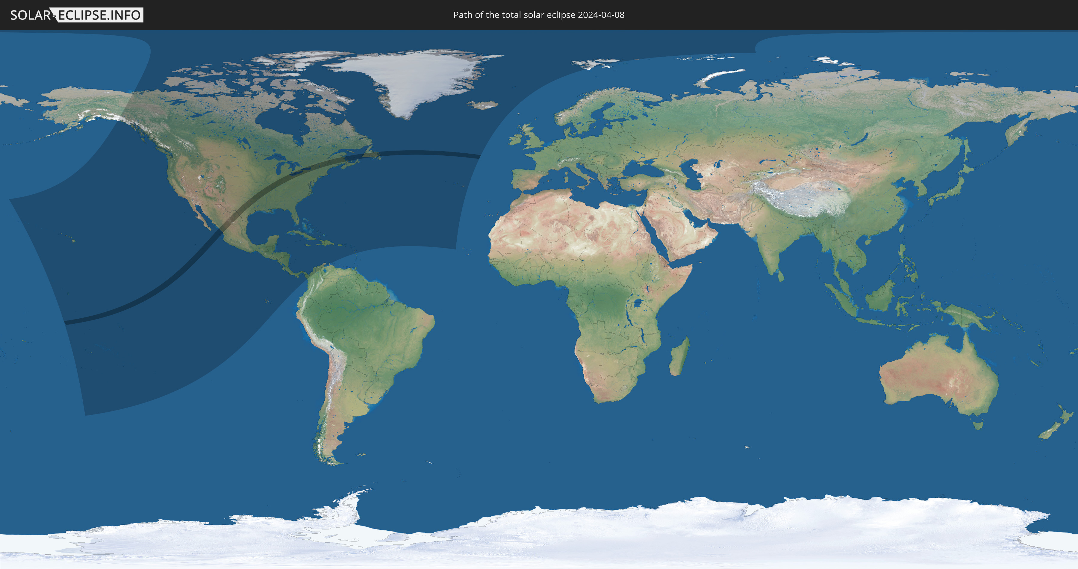
Die Sonnenfinsternis am 04/08/2024 kann man in 43 Ländern als partielle Sonnenfinsternis beobachten.
Der Finsternispfad verläuft durch 3 Länder. Nur in diesen Ländern ist sie als total Sonnenfinsternis zu sehen.
In den folgenden Ländern ist die Sonnenfinsternis total zu sehen
 United States
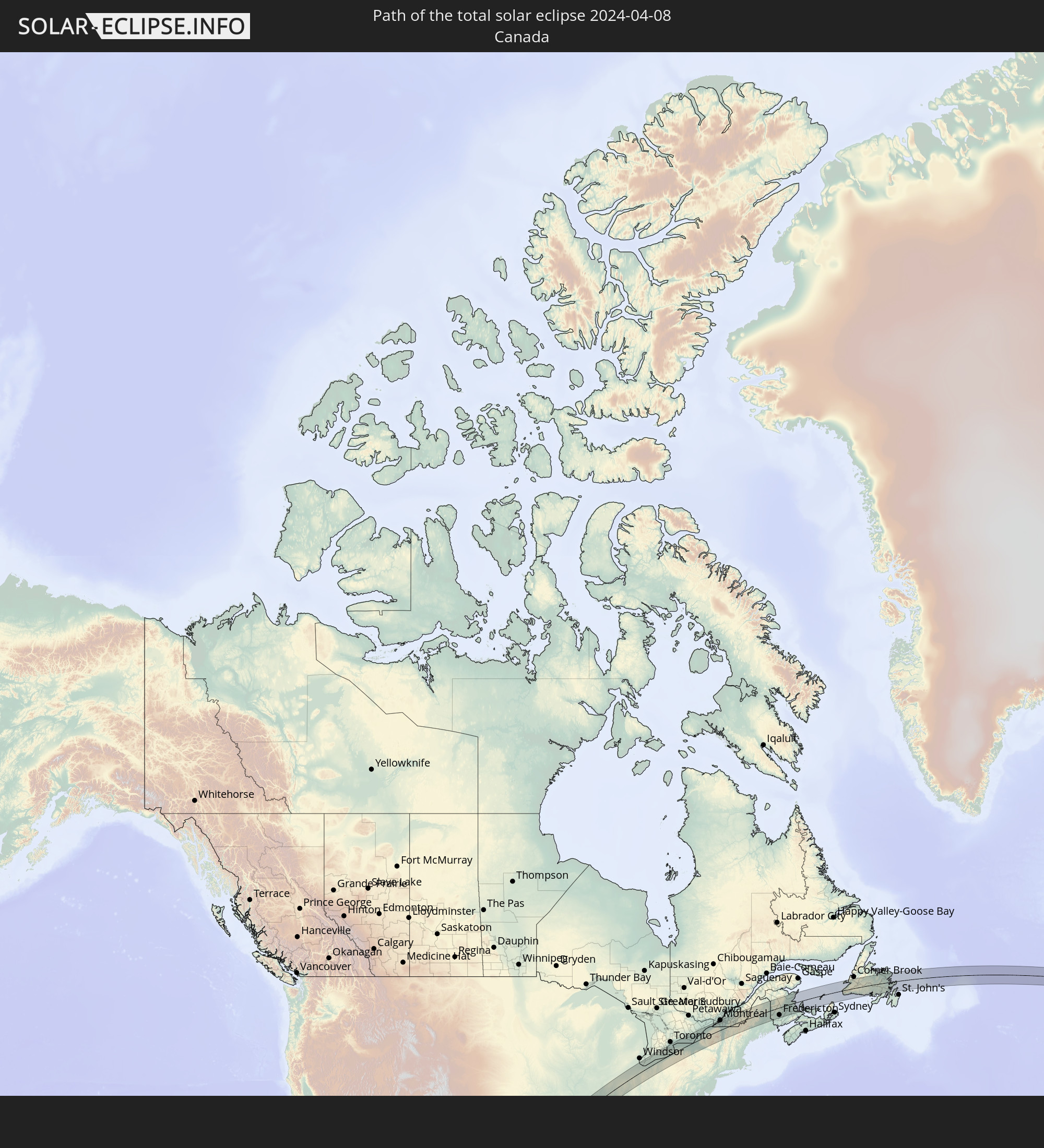 Canada
 Mexico
In den folgenden Ländern ist die Sonnenfinsternis partiell zu sehen
 United States
 United States Minor Outlying Islands
 Kiribati
 Cook Islands
 French Polynesia
 Canada
 Pitcairn Islands
 Mexico
 Greenland
 Guatemala
 Ecuador
 El Salvador
 Honduras
 Belize
 Nicaragua
 Costa Rica
 Cuba
Cuba
 Panama
 Colombia
 Cayman Islands
 The Bahamas
 Jamaica
 Haiti
Haiti
 Venezuela
 Turks and Caicos Islands
 Dominican Republic
 Aruba
Aruba
 Puerto Rico
 United States Virgin Islands
 Bermuda
 British Virgin Islands
 Anguilla
 Collectivity of Saint Martin
 Saint Barthélemy
 Saint Kitts and Nevis
 Antigua and Barbuda
 Montserrat
 Guadeloupe
 Dominica
 Saint Pierre and Miquelon
 Portugal
 Iceland
 Svalbard and Jan Mayen
How will be the weather during the total solar eclipse on 04/08/2024?
Where is the best place to see the total solar eclipse of 04/08/2024?
The following maps show the average cloud coverage for the day of the total solar eclipse.
With the help of these maps, it is possible to find the place along the eclipse path, which has the best
chance of a cloudless sky.
Nevertheless, you should consider local circumstances and inform about the weather of your chosen
observation site.
The data is provided by NASAs satellites
AQUA and TERRA.
The cloud maps are averaged over a period of 19 years (2000 - 2019).


Detailed country maps
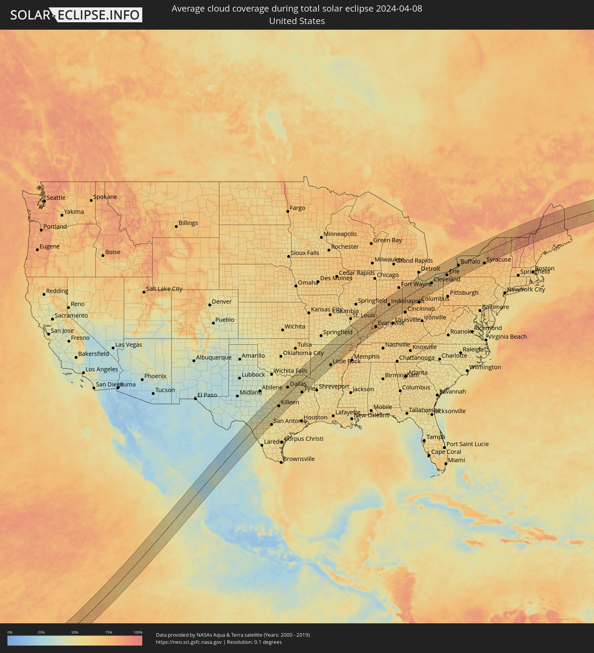 United States
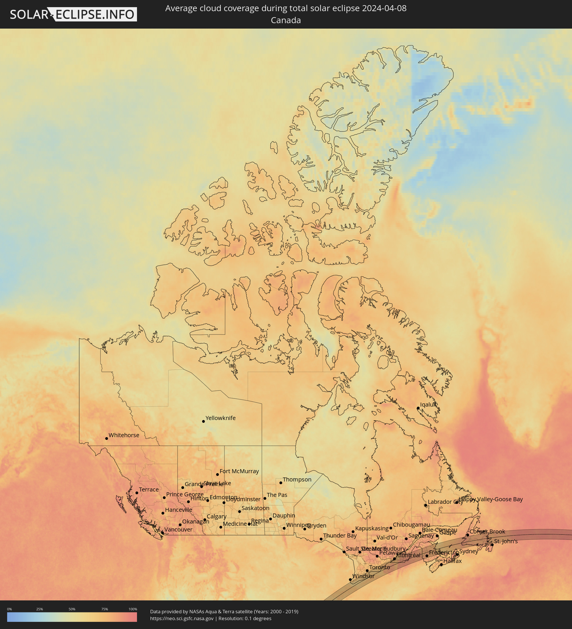 Canada
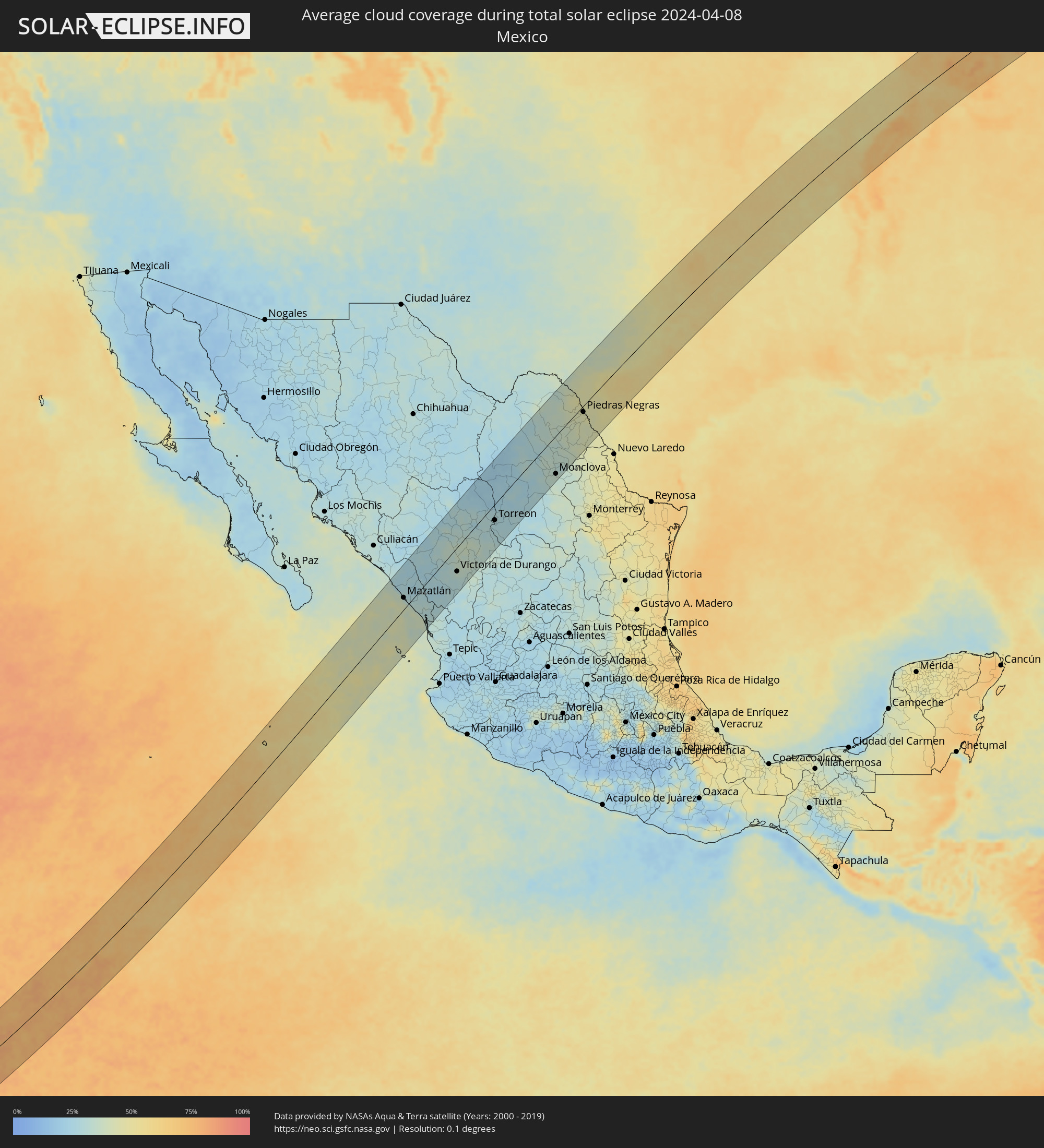 Mexico
Cities inside the path of the eclipse
The following table shows all locations with a population of more than 5,000 inside the eclipse path. Cities which have more than 100,000 inhabitants are marked bold. A click at the locations opens a detailed map.
| City | Type | Eclipse duration | Local time of max. eclipse | Distance to central line | Ø Cloud coverage |
|
Mazatlán, Sinaloa
|
total | - | 12:09:31 UTC-06:00 | 26 km | 35% |
|
Fraccionamiento los Ángeles, Sinaloa
|
total | - | 12:09:33 UTC-06:00 | 17 km | 30% |
|
Villa Unión, Sinaloa
|
total | - | 12:09:44 UTC-06:00 | 8 km | 30% |
|
Concordia, Sinaloa
|
total | - | 12:10:11 UTC-06:00 | 3 km | 28% |
|
Tayoltita, Durango
|
total | - | 13:12:00 UTC-05:00 | 52 km | 24% |
|
Isla del Bosque, Sinaloa
|
total | - | 12:09:26 UTC-06:00 | 54 km | 35% |
|
Escuinapa de Hidalgo, Sinaloa
|
total | - | 12:09:45 UTC-06:00 | 52 km | 30% |
|
Santiago Papasquiaro, Durango
|
total | - | 13:14:40 UTC-05:00 | 81 km | 30% |
|
Pueblo Nuevo, Durango
|
total | - | 13:11:28 UTC-05:00 | 43 km | 27% |
|
San Miguel de Papasquiaro, Durango
|
total | - | 13:14:23 UTC-05:00 | 59 km | 30% |
|
Nuevo Ideal, Durango
|
total | - | 13:14:55 UTC-05:00 | 43 km | 31% |
|
Canatlán, Durango
|
total | - | 13:14:43 UTC-05:00 | 6 km | 32% |
|
Victoria de Durango, Durango
|
total | - | 13:13:55 UTC-05:00 | 52 km | 35% |
|
Guadalupe Victoria, Durango
|
total | - | 13:15:37 UTC-05:00 | 62 km | 35% |
|
Peñón Blanco, Durango
|
total | - | 13:16:27 UTC-05:00 | 44 km | 35% |
|
Cuencamé, Durango
|
total | - | 13:17:09 UTC-05:00 | 63 km | 32% |
|
Bermejillo, Durango
|
total | - | 13:19:14 UTC-05:00 | 5 km | 28% |
|
Poanas, Durango
|
total | - | 13:19:02 UTC-05:00 | 4 km | 28% |
|
Ciudad Lerdo, Coahuila
|
total | - | 13:18:43 UTC-05:00 | 27 km | 28% |
|
Gomez Palacio, Durango
|
total | - | 13:18:50 UTC-05:00 | 27 km | 28% |
|
Tlahualilo de Zaragoza, Durango
|
total | - | 13:19:56 UTC-05:00 | 8 km | 22% |
|
Nazareno, Durango
|
total | - | 13:18:38 UTC-05:00 | 45 km | 27% |
|
Torreon, Coahuila
|
total | - | 13:18:54 UTC-05:00 | 35 km | 28% |
|
San Antonio del Coyote, Coahuila
|
total | - | 13:19:25 UTC-05:00 | 34 km | 28% |
|
Coyote, Coahuila
|
total | - | 13:19:25 UTC-05:00 | 34 km | 28% |
|
Matamoros, Coahuila
|
total | - | 13:19:11 UTC-05:00 | 51 km | 27% |
|
San Pedro, Coahuila
|
total | - | 13:19:02 UTC-05:00 | 58 km | 27% |
|
Concordia, Coahuila
|
total | - | 13:19:51 UTC-05:00 | 40 km | 28% |
|
San Buenaventura, Coahuila
|
total | - | 13:24:52 UTC-05:00 | 62 km | 33% |
|
Melchor Múzquiz, Coahuila
|
total | - | 13:26:26 UTC-05:00 | 3 km | 33% |
|
Ciudad Frontera, Coahuila
|
total | - | 13:24:47 UTC-05:00 | 79 km | 34% |
|
Castaños, Coahuila
|
total | - | 13:24:34 UTC-05:00 | 91 km | 33% |
|
Palau, Coahuila
|
total | - | 13:26:36 UTC-05:00 | 9 km | 32% |
|
Monclova, Coahuila
|
total | - | 13:24:48 UTC-05:00 | 83 km | 35% |
|
Minas de Barroterán, Coahuila
|
total | - | 13:26:24 UTC-05:00 | 37 km | 36% |
|
Nueva Rosita, Coahuila
|
total | - | 13:27:02 UTC-05:00 | 20 km | 35% |
|
Ciudad Sabinas, Coahuila
|
total | - | 13:27:03 UTC-05:00 | 34 km | 38% |
|
Ciudad Acuña, Coahuila
|
total | - | 13:29:57 UTC-05:00 | 64 km | 43% |
|
Zaragoza, Coahuila
|
total | - | 13:28:31 UTC-05:00 | 0 km | 41% |
|
Del Rio, Texas
|
total | - | 13:30:07 UTC-05:00 | 64 km | 41% |
|
Allende, Coahuila
|
total | - | 13:28:22 UTC-05:00 | 17 km | 40% |
|
Nava, Coahuila
|
total | - | 13:28:39 UTC-05:00 | 17 km | 40% |
|
Villa Union, Coahuila
|
total | - | 13:28:22 UTC-05:00 | 36 km | 43% |
|
Piedras Negras, Coahuila
|
total | - | 13:29:33 UTC-05:00 | 13 km | 43% |
|
Copperas Cove, Texas
|
total | - | 13:38:04 UTC-05:00 | 10 km | 52% |
|
Austin, Texas
|
total | - | 13:36:55 UTC-05:00 | 88 km | 57% |
|
Killeen, Texas
|
total | - | 13:38:21 UTC-05:00 | 23 km | 53% |
|
Round Rock, Texas
|
total | - | 13:37:26 UTC-05:00 | 73 km | 59% |
|
Temple, Texas
|
total | - | 13:38:58 UTC-05:00 | 50 km | 56% |
|
Fort Worth, Texas
|
total | - | 13:41:35 UTC-05:00 | 77 km | 58% |
|
Burleson, Texas
|
total | - | 13:41:18 UTC-05:00 | 62 km | 55% |
|
Keller, Texas
|
total | - | 13:42:02 UTC-05:00 | 88 km | 58% |
|
Waco, Texas
|
total | - | 13:40:01 UTC-05:00 | 28 km | 56% |
|
Mansfield, Texas
|
total | - | 13:41:38 UTC-05:00 | 52 km | 59% |
|
Arlington, Texas
|
total | - | 13:41:57 UTC-05:00 | 63 km | 60% |
|
Flower Mound, Texas
|
total | - | 13:42:24 UTC-05:00 | 85 km | 61% |
|
Carrollton, Texas
|
total | - | 13:42:39 UTC-05:00 | 66 km | 63% |
|
DeSoto, Texas
|
total | - | 13:42:08 UTC-05:00 | 35 km | 60% |
|
Frisco, Texas
|
total | - | 13:43:04 UTC-05:00 | 78 km | 61% |
|
Dallas, Texas
|
total | - | 13:42:31 UTC-05:00 | 47 km | 60% |
|
Plano, Texas
|
total | - | 13:43:04 UTC-05:00 | 59 km | 62% |
|
McKinney, Texas
|
total | - | 13:43:28 UTC-05:00 | 68 km | 59% |
|
Mesquite, Texas
|
total | - | 13:42:50 UTC-05:00 | 32 km | 62% |
|
Rowlett, Texas
|
total | - | 13:43:06 UTC-05:00 | 41 km | 61% |
|
Tyler, Texas
|
total | - | 13:44:20 UTC-05:00 | 86 km | 56% |
|
Texarkana, Texas
|
total | - | 13:48:01 UTC-05:00 | 78 km | 57% |
|
Hot Springs, Arkansas
|
total | - | 13:51:10 UTC-05:00 | 50 km | 52% |
|
Conway, Arkansas
|
total | - | 13:52:57 UTC-05:00 | 38 km | 54% |
|
Little Rock, Arkansas
|
total | - | 13:52:44 UTC-05:00 | 76 km | 53% |
|
Jonesboro, Arkansas
|
total | - | 13:56:42 UTC-05:00 | 76 km | 72% |
|
Cape Girardeau, Missouri
|
total | - | 14:00:18 UTC-05:00 | 16 km | 62% |
|
Evansville, Indiana
|
total | - | 14:04:03 UTC-05:00 | 62 km | 69% |
|
Terre Haute, Indiana
|
total | - | 15:05:44 UTC-04:00 | 65 km | 66% |
|
Bloomington, Indiana
|
total | - | 15:06:46 UTC-04:00 | 7 km | 65% |
|
Indianapolis, Indiana
|
total | - | 15:07:52 UTC-04:00 | 29 km | 68% |
|
Carmel, Indiana
|
total | - | 15:08:07 UTC-04:00 | 47 km | 68% |
|
Greenwood, Indiana
|
total | - | 15:07:48 UTC-04:00 | 13 km | 70% |
|
Columbus, Indiana
|
total | - | 15:07:42 UTC-04:00 | 34 km | 68% |
|
Anderson, Indiana
|
total | - | 15:08:52 UTC-04:00 | 37 km | 70% |
|
Muncie, Indiana
|
total | - | 15:09:22 UTC-04:00 | 31 km | 71% |
|
Richmond, Indiana
|
total | - | 15:09:46 UTC-04:00 | 26 km | 73% |
|
Hamilton, Ohio
|
total | - | 15:09:53 UTC-04:00 | 82 km | 68% |
|
Middletown, Ohio
|
total | - | 15:10:14 UTC-04:00 | 79 km | 68% |
|
Dayton, Ohio
|
total | - | 15:10:44 UTC-04:00 | 66 km | 67% |
|
Lima, Ohio
|
total | - | 15:11:39 UTC-04:00 | 21 km | 73% |
|
Fairborn, Ohio
|
total | - | 15:11:02 UTC-04:00 | 68 km | 71% |
|
Springfield, Ohio
|
total | - | 15:11:25 UTC-04:00 | 69 km | 73% |
|
Findlay, Ohio
|
total | - | 15:12:31 UTC-04:00 | 29 km | 74% |
|
Toledo, Ohio
|
total | - | 15:13:06 UTC-04:00 | 83 km | 68% |
|
Marion, Ohio
|
total | - | 15:12:55 UTC-04:00 | 38 km | 71% |
|
Dublin, Ohio
|
total | - | 15:12:34 UTC-04:00 | 84 km | 70% |
|
Delaware, Ohio
|
total | - | 15:12:47 UTC-04:00 | 68 km | 71% |
|
Westerville, Ohio
|
total | - | 15:12:51 UTC-04:00 | 90 km | 69% |
|
Mansfield, Ohio
|
total | - | 15:13:54 UTC-04:00 | 49 km | 70% |
|
Lorain, Ohio
|
total | - | 15:14:51 UTC-04:00 | 2 km | 63% |
|
Westlake, Ohio
|
total | - | 15:15:13 UTC-04:00 | 9 km | 67% |
|
Strongsville, Ohio
|
total | - | 15:15:14 UTC-04:00 | 26 km | 70% |
|
Cleveland, Ohio
|
total | - | 15:15:33 UTC-04:00 | 14 km | 66% |
|
Euclid, Ohio
|
total | - | 15:15:51 UTC-04:00 | 13 km | 62% |
|
Massillon, Ohio
|
total | - | 15:15:20 UTC-04:00 | 89 km | 71% |
|
Akron, Ohio
|
total | - | 15:15:31 UTC-04:00 | 62 km | 68% |
|
Mentor, Ohio
|
total | - | 15:16:09 UTC-04:00 | 14 km | 62% |
|
St. Thomas, Ontario
|
total | - | 15:17:02 UTC-04:00 | 86 km | 71% |
|
Aylmer, Ontario
|
total | - | 15:17:17 UTC-04:00 | 77 km | 69% |
|
Warren, Ohio
|
total | - | 15:16:36 UTC-04:00 | 77 km | 68% |
|
Norfolk County, Ontario
|
total | - | 15:18:07 UTC-04:00 | 59 km | 70% |
|
Brant, Ontario
|
total | - | 15:18:19 UTC-04:00 | 87 km | 70% |
|
Brantford, Ontario
|
total | - | 15:18:26 UTC-04:00 | 84 km | 70% |
|
Erie, Pennsylvania
|
total | - | 15:18:07 UTC-04:00 | 21 km | 68% |
|
Ancaster, Ontario
|
total | - | 15:18:50 UTC-04:00 | 81 km | 72% |
|
Hamilton, Ontario
|
total | - | 15:19:02 UTC-04:00 | 78 km | 71% |
|
Welland, Ontario
|
total | - | 15:19:41 UTC-04:00 | 29 km | 71% |
|
St. Catharines, Ontario
|
total | - | 15:19:47 UTC-04:00 | 47 km | 69% |
|
Port Colborne, Ontario
|
total | - | 15:19:39 UTC-04:00 | 20 km | 69% |
|
Thorold, Ontario
|
total | - | 15:19:48 UTC-04:00 | 40 km | 71% |
|
Niagara Falls, Ontario
|
total | - | 15:19:58 UTC-04:00 | 33 km | 70% |
|
Niagara Falls, New York
|
total | - | 15:19:59 UTC-04:00 | 32 km | 70% |
|
Fort Erie, Ontario
|
total | - | 15:20:03 UTC-04:00 | 8 km | 70% |
|
Buffalo, New York
|
total | - | 15:20:07 UTC-04:00 | 5 km | 70% |
|
North Tonawanda, New York
|
total | - | 15:20:12 UTC-04:00 | 19 km | 70% |
|
Cobourg, Ontario
|
total | - | 15:21:30 UTC-04:00 | 83 km | 70% |
|
Rochester, New York
|
total | - | 15:21:51 UTC-04:00 | 17 km | 70% |
|
Belleville, Ontario
|
total | - | 15:22:33 UTC-04:00 | 75 km | 70% |
|
Prince Edward, Ontario
|
total | - | 15:22:39 UTC-04:00 | 54 km | 69% |
|
Greater Napanee, Ontario
|
total | - | 15:23:07 UTC-04:00 | 68 km | 74% |
|
Kingston, Ontario
|
total | - | 15:23:41 UTC-04:00 | 49 km | 73% |
|
Syracuse, New York
|
total | - | 15:23:40 UTC-04:00 | 81 km | 73% |
|
Brockville, Ontario
|
total | - | 15:24:45 UTC-04:00 | 58 km | 78% |
|
Cornwall, Ontario
|
total | - | 15:26:00 UTC-04:00 | 69 km | 74% |
|
Les Coteaux, Quebec
|
total | - | 15:26:39 UTC-04:00 | 80 km | 73% |
|
Salaberry-de-Valleyfield, Quebec
|
total | - | 15:26:45 UTC-04:00 | 73 km | 75% |
|
Vaudreuil-Dorion, Quebec
|
total | - | 15:26:54 UTC-04:00 | 85 km | 75% |
|
Pincourt, Quebec
|
total | - | 15:26:57 UTC-04:00 | 82 km | 75% |
|
L'Île-Perrot, Quebec
|
total | - | 15:26:59 UTC-04:00 | 81 km | 74% |
|
Notre-Dame-de-l'Île-Perrot, Quebec
|
total | - | 15:27:00 UTC-04:00 | 78 km | 74% |
|
Beauharnois, Quebec
|
total | - | 15:27:04 UTC-04:00 | 71 km | 74% |
|
Beaconsfield, Quebec
|
total | - | 15:27:06 UTC-04:00 | 83 km | 74% |
|
Kirkland, Quebec
|
total | - | 15:27:06 UTC-04:00 | 85 km | 73% |
|
Pointe-Claire, Quebec
|
total | - | 15:27:09 UTC-04:00 | 83 km | 73% |
|
Dorval, Quebec
|
total | - | 15:27:13 UTC-04:00 | 81 km | 73% |
|
Châteauguay, Quebec
|
total | - | 15:27:13 UTC-04:00 | 74 km | 73% |
|
Mercier, Quebec
|
total | - | 15:27:12 UTC-04:00 | 67 km | 74% |
|
Côte-Saint-Luc, Quebec
|
total | - | 15:27:20 UTC-04:00 | 80 km | 76% |
|
Mont-Royal, Quebec
|
total | - | 15:27:21 UTC-04:00 | 85 km | 77% |
|
Saint-Raymond, Quebec
|
total | - | 15:27:24 UTC-04:00 | 78 km | 77% |
|
Westmount, Quebec
|
total | - | 15:27:24 UTC-04:00 | 80 km | 77% |
|
Montréal, Quebec
|
total | - | 15:27:25 UTC-04:00 | 82 km | 77% |
|
Saint-Constant, Quebec
|
total | - | 15:27:25 UTC-04:00 | 67 km | 75% |
|
Delson, Quebec
|
total | - | 15:27:26 UTC-04:00 | 66 km | 75% |
|
Candiac, Quebec
|
total | - | 15:27:29 UTC-04:00 | 67 km | 75% |
|
La Prairie, Quebec
|
total | - | 15:27:30 UTC-04:00 | 70 km | 75% |
|
Saint-Bruno-de-Montarville, Quebec
|
total | - | 15:27:42 UTC-04:00 | 77 km | 76% |
|
Sainte-Julie, Quebec
|
total | - | 15:27:44 UTC-04:00 | 82 km | 77% |
|
Carignan, Quebec
|
total | - | 15:27:44 UTC-04:00 | 67 km | 76% |
|
Chambly, Quebec
|
total | - | 15:27:46 UTC-04:00 | 66 km | 76% |
|
Saint-Basile-le-Grand, Quebec
|
total | - | 15:27:46 UTC-04:00 | 75 km | 76% |
|
Saint-Jean-sur-Richelieu, Quebec
|
total | - | 15:27:45 UTC-04:00 | 51 km | 76% |
|
Otterburn Park, Quebec
|
total | - | 15:27:51 UTC-04:00 | 73 km | 75% |
|
Burlington, Vermont
|
total | - | 15:27:39 UTC-04:00 | 35 km | 74% |
|
Mont-Saint-Hilaire, Quebec
|
total | - | 15:27:52 UTC-04:00 | 76 km | 77% |
|
Beloeil, Quebec
|
total | - | 15:27:52 UTC-04:00 | 76 km | 77% |
|
Saint-Hyacinthe, Quebec
|
total | - | 15:28:09 UTC-04:00 | 75 km | 76% |
|
Cowansville, Quebec
|
total | - | 15:28:19 UTC-04:00 | 24 km | 85% |
|
Granby, Quebec
|
total | - | 15:28:22 UTC-04:00 | 44 km | 85% |
|
Drummondville, Quebec
|
total | - | 15:28:43 UTC-04:00 | 86 km | 80% |
|
Magog, Quebec
|
total | - | 15:29:00 UTC-04:00 | 13 km | 86% |
|
Rock Forest, Quebec
|
total | - | 15:29:11 UTC-04:00 | 18 km | 85% |
|
Asbestos, Quebec
|
total | - | 15:29:19 UTC-04:00 | 58 km | 86% |
|
Sherbrooke, Quebec
|
total | - | 15:29:18 UTC-04:00 | 19 km | 85% |
|
Thetford-Mines, Quebec
|
total | - | 15:30:02 UTC-04:00 | 74 km | 85% |
|
Saint-Georges, Quebec
|
total | - | 15:30:43 UTC-04:00 | 58 km | 87% |
|
Fredericton, New Brunswick
|
total | - | 16:34:50 UTC-03:00 | 63 km | 80% |
|
Oromocto, New Brunswick
|
total | - | 16:35:02 UTC-03:00 | 80 km | 79% |
|
Miramichi, New Brunswick
|
total | - | 16:35:52 UTC-03:00 | 25 km | 79% |
|
Lutes Mountain, New Brunswick
|
total | - | 16:36:32 UTC-03:00 | 84 km | 80% |
|
Summerside, Prince Edward Island
|
total | - | 16:37:33 UTC-03:00 | 80 km | 73% |
|
Grand Falls-Windsor, Newfoundland and Labrador
|
total | - | 17:13:18 UTC-02:30 | 63 km | 82% |