Total solar eclipse of 01/08/2103
| Day of week: | Monday |
| Maximum duration of eclipse: | 02m57s |
| Maximum width of eclipse path: | 140 km |
| Saros cycle: | 133 |
| Coverage: | 100% |
| Magnitude: | 1.0381 |
| Gamma: | -0.414 |
Wo kann man die Sonnenfinsternis vom 01/08/2103 sehen?
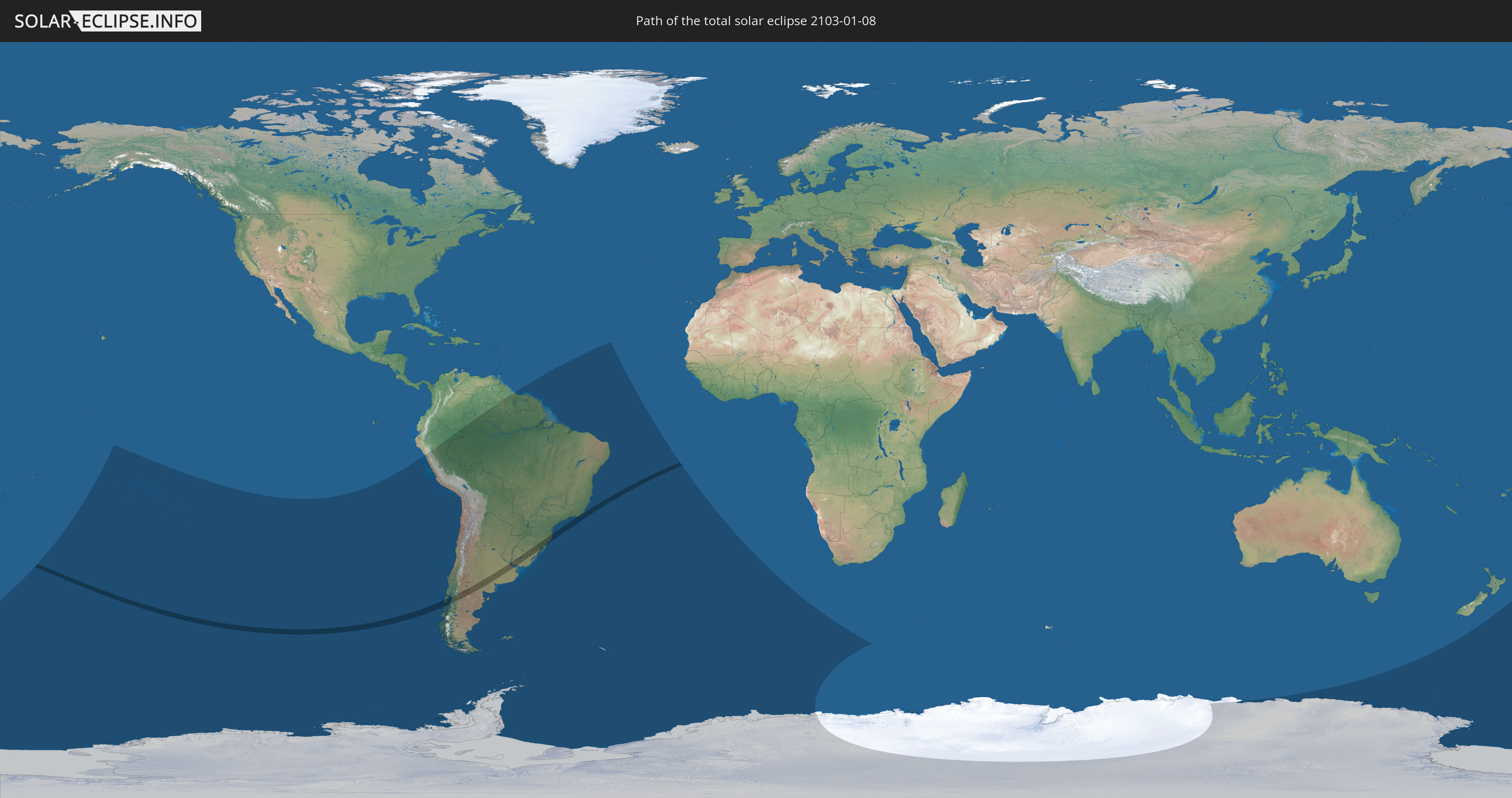
Die Sonnenfinsternis am 01/08/2103 kann man in 22 Ländern als partielle Sonnenfinsternis beobachten.
Der Finsternispfad verläuft durch 4 Länder. Nur in diesen Ländern ist sie als total Sonnenfinsternis zu sehen.
In den folgenden Ländern ist die Sonnenfinsternis total zu sehen
 Chile
Chile
 Brazil
 Argentina
 Uruguay
In den folgenden Ländern ist die Sonnenfinsternis partiell zu sehen
 Antarctica
 New Zealand
 Kiribati
 Cook Islands
 French Polynesia
 Pitcairn Islands
 Chile
Chile
 Colombia
 Peru
Peru
 Brazil
 Argentina
 Venezuela
 Bolivia
 Paraguay
 Falkland Islands
 Guyana
 Uruguay
 Suriname
 French Guiana
 South Georgia and the South Sandwich Islands
 Saint Helena, Ascension and Tristan da Cunha
 Bouvet Island
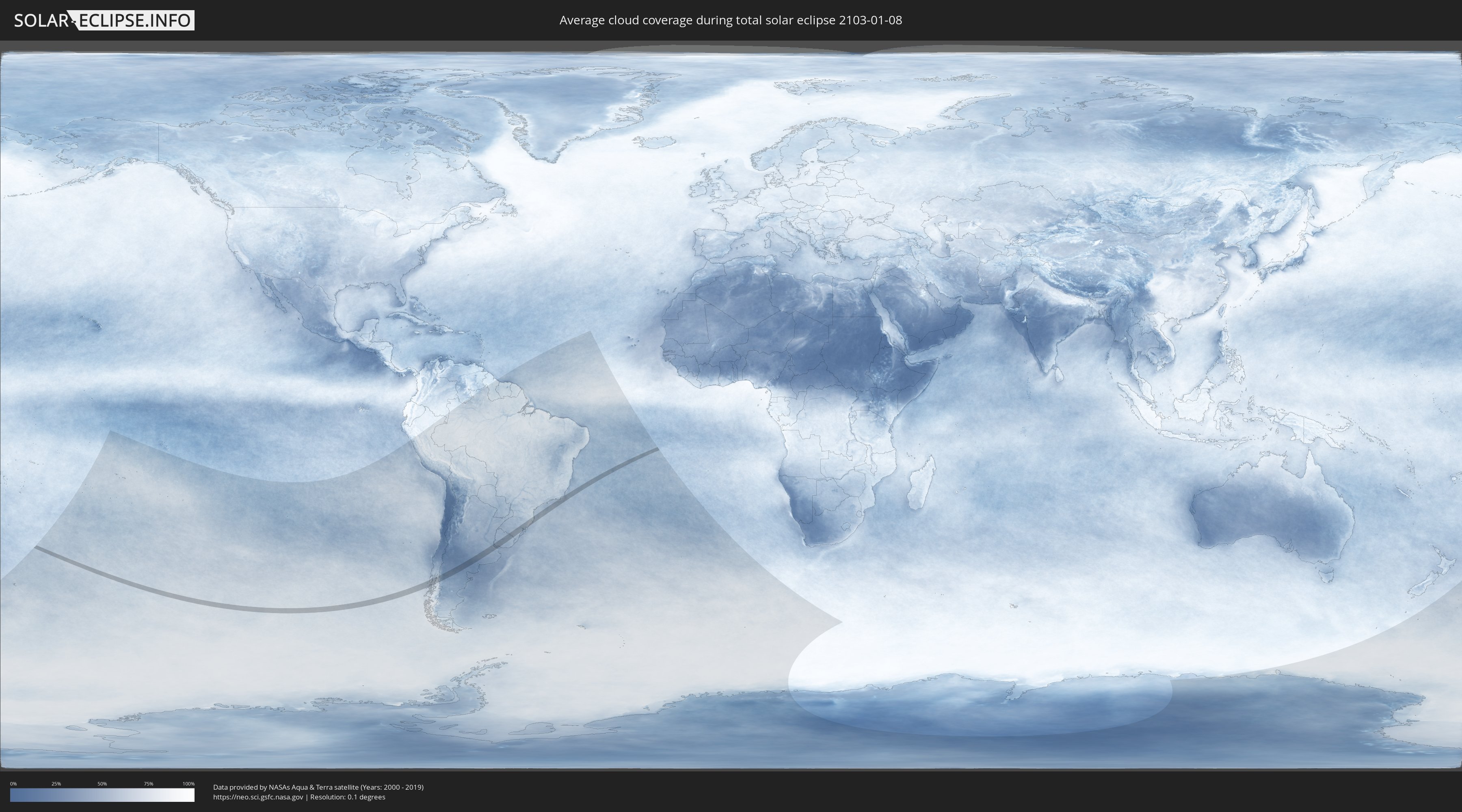
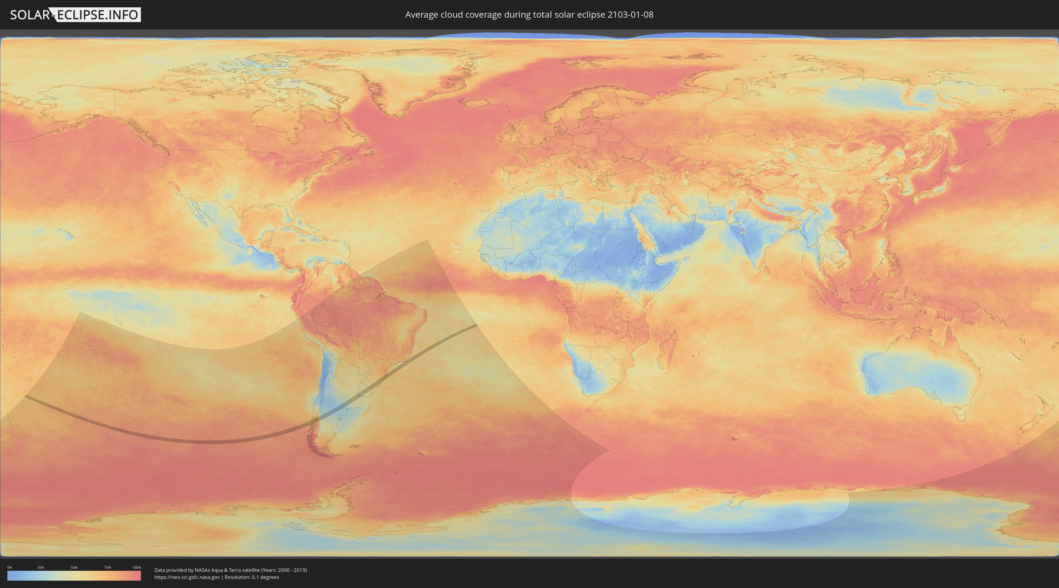
How will be the weather during the total solar eclipse on 01/08/2103?
Where is the best place to see the total solar eclipse of 01/08/2103?
The following maps show the average cloud coverage for the day of the total solar eclipse.
With the help of these maps, it is possible to find the place along the eclipse path, which has the best
chance of a cloudless sky.
Nevertheless, you should consider local circumstances and inform about the weather of your chosen
observation site.
The data is provided by NASAs satellites
AQUA and TERRA.
The cloud maps are averaged over a period of 19 years (2000 - 2019).
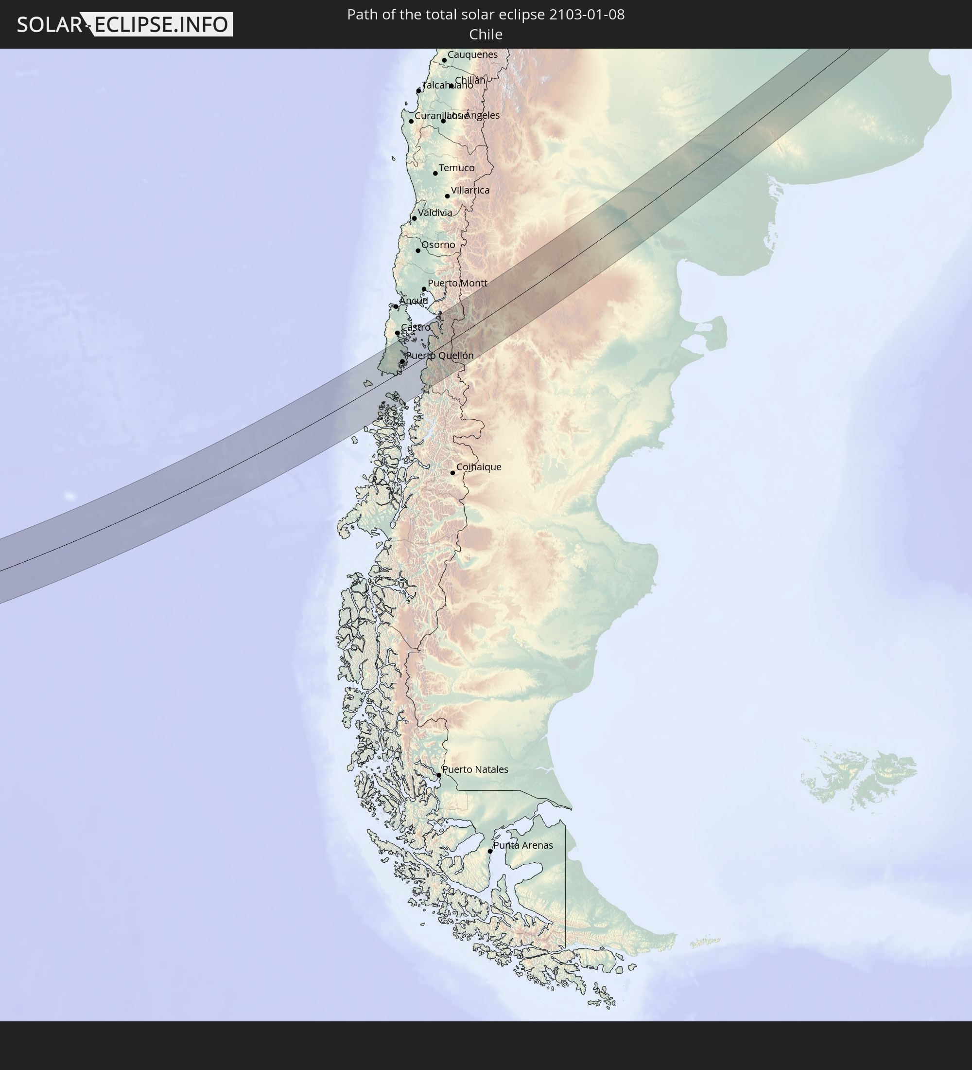
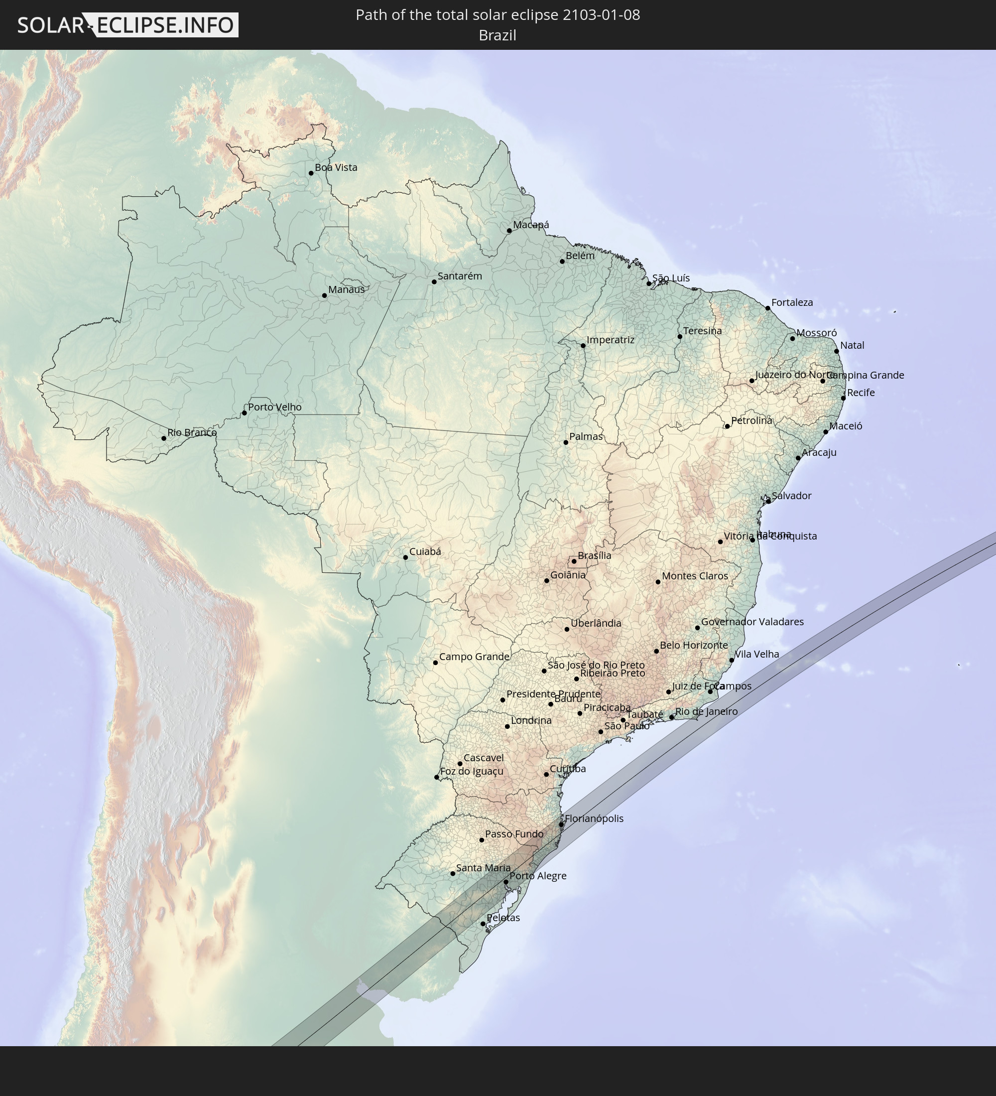
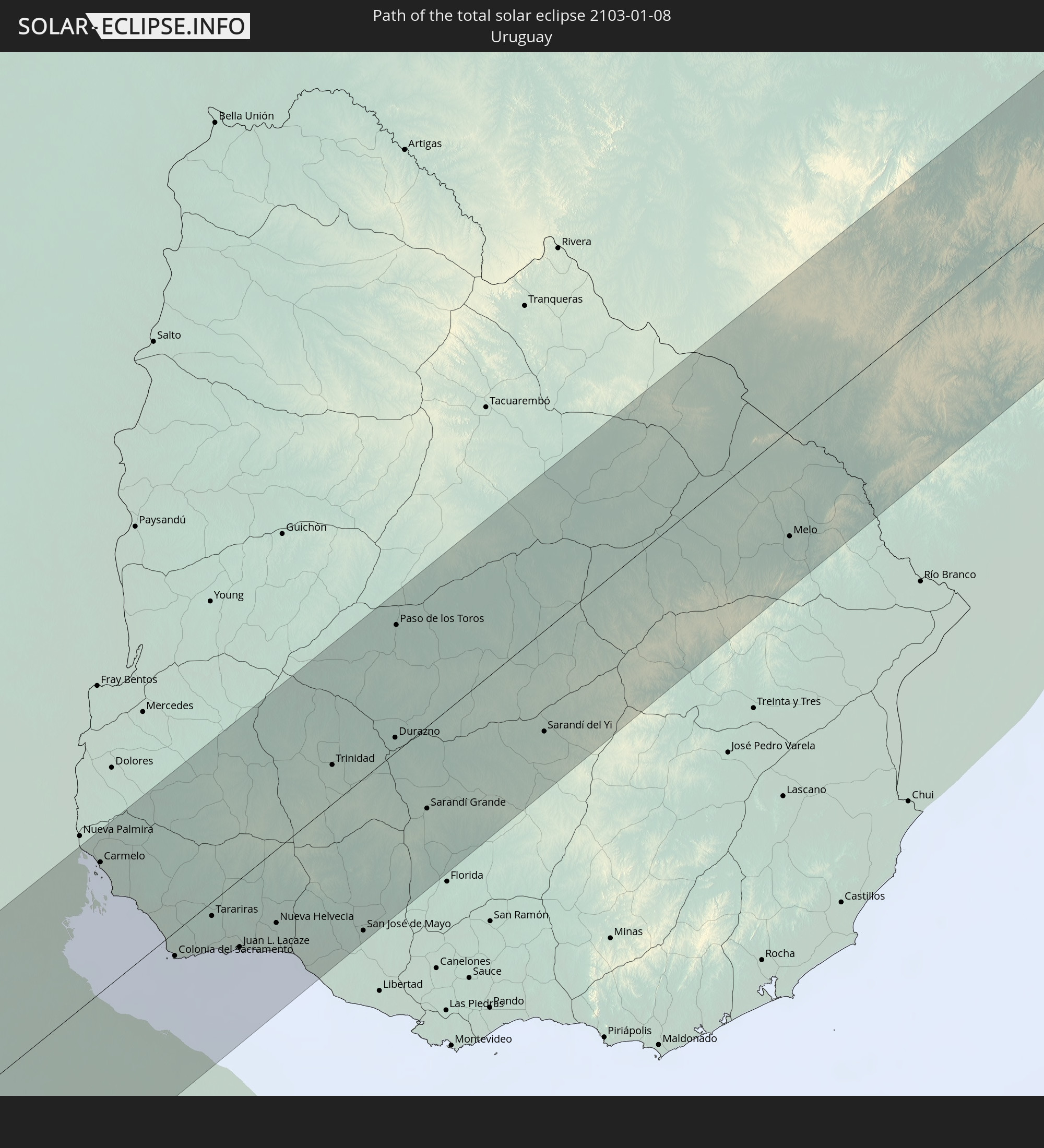
Detailed country maps
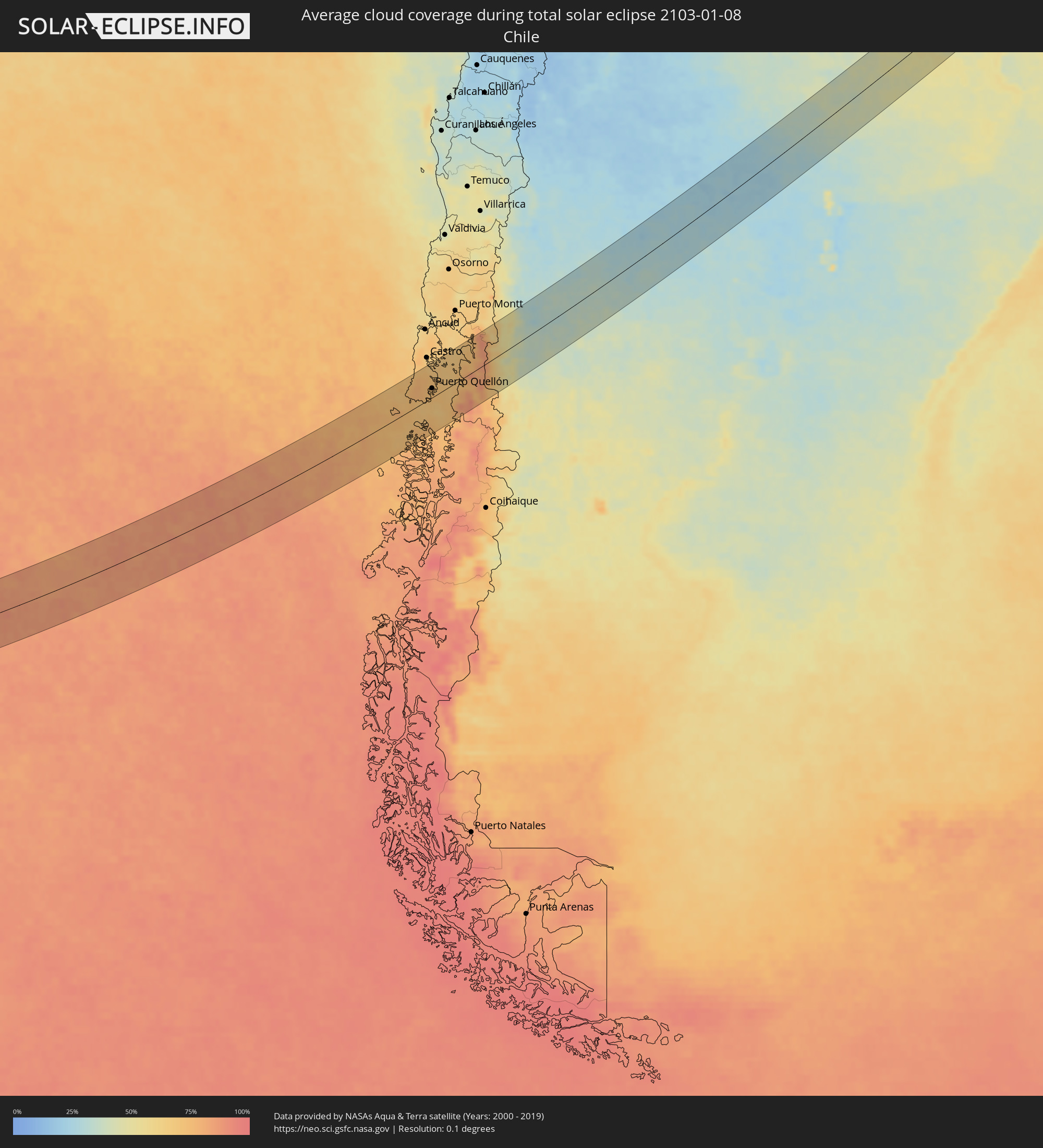 Chile
Chile
 Brazil
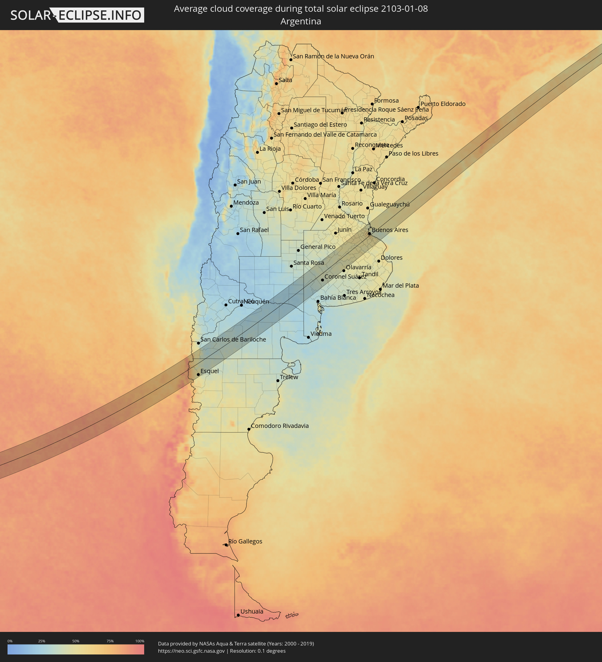 Argentina
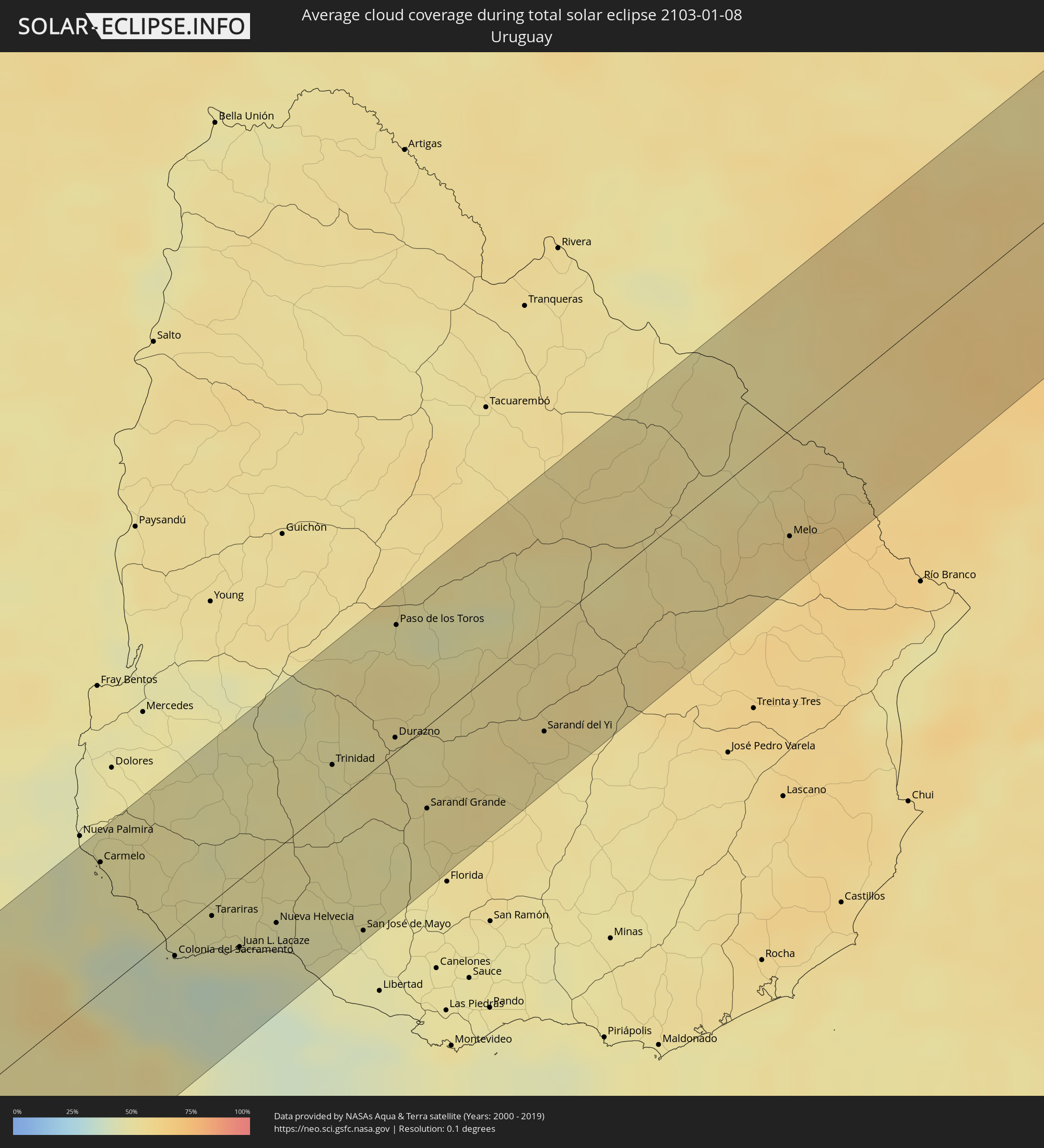 Uruguay
Cities inside the path of the eclipse
The following table shows all locations with a population of more than 5,000 inside the eclipse path. Cities which have more than 100,000 inhabitants are marked bold. A click at the locations opens a detailed map.
| City | Type | Eclipse duration | Local time of max. eclipse | Distance to central line | Ø Cloud coverage |
|
Puerto Quellón, Los Lagos
|
total | - | 15:15:59 UTC-03:00 | 18 km | 72% |
|
El Bolsón, Río Negro Province
|
total | - | 15:20:49 UTC-03:00 | 36 km | 50% |
|
Esquel, Chubut Province
|
total | - | 15:19:44 UTC-03:00 | 62 km | 49% |
|
Ingeniero Jacobacci, Río Negro Province
|
total | - | 15:24:43 UTC-03:00 | 3 km | 34% |
|
Fray Luis Beltrán, Río Negro Province
|
total | - | 15:33:14 UTC-03:00 | 1 km | 27% |
|
Lamarque, Río Negro Province
|
total | - | 15:33:09 UTC-03:00 | 14 km | 27% |
|
Choele Choel, Río Negro Province
|
total | - | 15:33:25 UTC-03:00 | 1 km | 26% |
|
Guatraché, La Pampa Province
|
total | - | 15:38:55 UTC-03:00 | 28 km | 29% |
|
Coronel Suárez, Buenos Aires
|
total | - | 15:41:16 UTC-03:00 | 39 km | 36% |
|
Veinticinco de Mayo, Buenos Aires
|
total | - | 15:46:49 UTC-03:00 | 39 km | 49% |
|
Mercedes, Buenos Aires
|
total | - | 15:49:01 UTC-03:00 | 65 km | 54% |
|
Luján, Buenos Aires
|
total | - | 15:49:31 UTC-03:00 | 53 km | 50% |
|
Pontevedra, Buenos Aires
|
total | - | 15:49:39 UTC-03:00 | 15 km | 54% |
|
Morón, Buenos Aires
|
total | - | 15:49:55 UTC-03:00 | 18 km | 55% |
|
Tigre, Buenos Aires
|
total | - | 15:50:21 UTC-03:00 | 36 km | 54% |
|
San Isidro, Buenos Aires
|
total | - | 15:50:19 UTC-03:00 | 29 km | 56% |
|
Villa Santa Rita, Buenos Aires F.D.
|
total | - | 15:50:08 UTC-03:00 | 14 km | 59% |
|
Villa Lugano, Buenos Aires F.D.
|
total | - | 15:50:01 UTC-03:00 | 8 km | 56% |
|
Colegiales, Buenos Aires F.D.
|
total | - | 15:50:14 UTC-03:00 | 15 km | 58% |
|
Adrogué, Buenos Aires
|
total | - | 15:49:55 UTC-03:00 | 8 km | 55% |
|
Retiro, Buenos Aires F.D.
|
total | - | 15:50:17 UTC-03:00 | 11 km | 58% |
|
Buenos Aires, Buenos Aires F.D.
|
total | - | 15:50:14 UTC-03:00 | 8 km | 58% |
|
Carmelo, Colonia
|
total | - | 15:51:24 UTC-03:00 | 55 km | 47% |
|
Quilmes, Buenos Aires
|
total | - | 15:50:10 UTC-03:00 | 9 km | 59% |
|
La Plata, Buenos Aires
|
total | - | 15:50:10 UTC-03:00 | 43 km | 54% |
|
Colonia del Sacramento, Colonia
|
total | - | 15:51:05 UTC-03:00 | 10 km | 39% |
|
Tarariras, Colonia
|
total | - | 15:51:39 UTC-03:00 | 6 km | 46% |
|
Juan L. Lacaze, Colonia
|
total | - | 15:51:34 UTC-03:00 | 29 km | 44% |
|
Rosario, Colonia
|
total | - | 15:51:51 UTC-03:00 | 26 km | 47% |
|
Nueva Helvecia, Colonia
|
total | - | 15:52:00 UTC-03:00 | 31 km | 45% |
|
Trinidad, Flores
|
total | - | 15:53:41 UTC-03:00 | 17 km | 48% |
|
Trinidad, Flores
|
total | - | 15:53:39 UTC-03:00 | 14 km | 48% |
|
San José de Mayo, San José
|
total | - | 15:52:28 UTC-03:00 | 65 km | 47% |
|
Durazno, Durazno
|
total | - | 15:54:18 UTC-03:00 | 6 km | 51% |
|
Paso de los Toros, Tacuarembó
|
total | - | 15:55:17 UTC-03:00 | 55 km | 49% |
|
Sarandí Grande, Florida
|
total | - | 15:53:53 UTC-03:00 | 35 km | 53% |
|
Sarandí del Yi, Durazno
|
total | - | 15:55:14 UTC-03:00 | 44 km | 53% |
|
Melo, Cerro Largo
|
total | - | 15:58:18 UTC-03:00 | 46 km | 59% |
|
Bagé, Rio Grande do Sul
|
total | - | 16:00:07 UTC-03:00 | 39 km | 55% |
|
Herval, Rio Grande do Sul
|
total | - | 15:59:35 UTC-03:00 | 63 km | 60% |
|
Canguçu, Rio Grande do Sul
|
total | - | 16:01:16 UTC-03:00 | 52 km | 64% |
|
Encruzilhada do Sul, Rio Grande do Sul
|
total | - | 16:02:49 UTC-03:00 | 12 km | 62% |
|
Rio Pardo, Rio Grande do Sul
|
total | - | 16:03:52 UTC-03:00 | 51 km | 58% |
|
Butiá, Rio Grande do Sul
|
total | - | 16:04:00 UTC-03:00 | 15 km | 61% |
|
Taquari, Rio Grande do Sul
|
total | - | 16:04:37 UTC-03:00 | 37 km | 54% |
|
Camaquã, Rio Grande do Sul
|
total | - | 16:02:54 UTC-03:00 | 57 km | 61% |
|
Teutônia, Rio Grande do Sul
|
total | - | 16:05:14 UTC-03:00 | 64 km | 60% |
|
São Jerônimo, Rio Grande do Sul
|
total | - | 16:04:28 UTC-03:00 | 14 km | 59% |
|
Charqueadas, Rio Grande do Sul
|
total | - | 16:04:33 UTC-03:00 | 9 km | 58% |
|
Garibaldi, Rio Grande do Sul
|
total | - | 16:05:46 UTC-03:00 | 64 km | 64% |
|
Carlos Barbosa, Rio Grande do Sul
|
total | - | 16:05:44 UTC-03:00 | 58 km | 64% |
|
Montenegro, Rio Grande do Sul
|
total | - | 16:05:07 UTC-03:00 | 22 km | 61% |
|
Tapes, Rio Grande do Sul
|
total | - | 16:03:32 UTC-03:00 | 67 km | 54% |
|
São Sebastião do Caí, Rio Grande do Sul
|
total | - | 16:05:21 UTC-03:00 | 25 km | 64% |
|
Farroupilha, Rio Grande do Sul
|
total | - | 16:05:58 UTC-03:00 | 55 km | 64% |
|
Portão, Rio Grande do Sul
|
total | - | 16:05:16 UTC-03:00 | 7 km | 62% |
|
Porto Alegre, Rio Grande do Sul
|
total | - | 16:04:44 UTC-03:00 | 22 km | 63% |
|
Flores da Cunha, Rio Grande do Sul
|
total | - | 16:06:26 UTC-03:00 | 62 km | 65% |
|
Caxias do Sul, Rio Grande do Sul
|
total | - | 16:06:12 UTC-03:00 | 50 km | 66% |
|
Ivoti, Rio Grande do Sul
|
total | - | 16:05:31 UTC-03:00 | 12 km | 64% |
|
Sapucaia, Rio Grande do Sul
|
total | - | 16:05:07 UTC-03:00 | 10 km | 63% |
|
Novo Hamburgo, Rio Grande do Sul
|
total | - | 16:05:24 UTC-03:00 | 3 km | 63% |
|
São Marcos, Rio Grande do Sul
|
total | - | 16:06:37 UTC-03:00 | 60 km | 65% |
|
Viamão, Rio Grande do Sul
|
total | - | 16:04:49 UTC-03:00 | 39 km | 64% |
|
Gravataí, Rio Grande do Sul
|
total | - | 16:05:04 UTC-03:00 | 29 km | 64% |
|
Parobé, Rio Grande do Sul
|
total | - | 16:05:42 UTC-03:00 | 11 km | 62% |
|
Canela, Rio Grande do Sul
|
total | - | 16:06:10 UTC-03:00 | 11 km | 63% |
|
Igrejinha, Rio Grande do Sul
|
total | - | 16:05:50 UTC-03:00 | 9 km | 62% |
|
Três Coroas, Rio Grande do Sul
|
total | - | 16:05:56 UTC-03:00 | 5 km | 64% |
|
Torres, Rio Grande do Sul
|
total | - | 16:07:01 UTC-03:00 | 53 km | 65% |
|
Araranguá, Santa Catarina
|
total | - | 16:07:50 UTC-03:00 | 33 km | 69% |
|
Forquilhinha, Santa Catarina
|
total | - | 16:08:10 UTC-03:00 | 18 km | 72% |
|
Criciúma, Santa Catarina
|
total | - | 16:08:21 UTC-03:00 | 18 km | 73% |
|
Braço do Norte, Santa Catarina
|
total | - | 16:09:09 UTC-03:00 | 5 km | 71% |
|
São José, Santa Catarina
|
total | - | 16:09:15 UTC-03:00 | 10 km | 70% |
|
Tubarão, Santa Catarina
|
total | - | 16:08:57 UTC-03:00 | 22 km | 69% |
|
Laguna, Santa Catarina
|
total | - | 16:09:04 UTC-03:00 | 37 km | 66% |
|
Santo Amaro da Imperatriz, Santa Catarina
|
total | - | 16:10:21 UTC-03:00 | 32 km | 81% |
|
Imbituba, Santa Catarina
|
total | - | 16:09:32 UTC-03:00 | 22 km | 67% |
|
Biguaçu, Santa Catarina
|
total | - | 16:10:45 UTC-03:00 | 42 km | 77% |
|
Tijucas, Santa Catarina
|
total | - | 16:11:10 UTC-03:00 | 63 km | 73% |
|
Campinas, Santa Catarina
|
total | - | 16:10:37 UTC-03:00 | 30 km | 76% |
|
Freguesia do Ribeirao da Ilha, Santa Catarina
|
total | - | 16:10:27 UTC-03:00 | 17 km | 75% |
|
Florianópolis, Santa Catarina
|
total | - | 16:10:39 UTC-03:00 | 26 km | 73% |
|
Ribeirão da Ilha, Santa Catarina
|
total | - | 16:10:30 UTC-03:00 | 16 km | 72% |
|
Arraial do Cabo, Rio de Janeiro
|
total | - | 16:21:09 UTC-03:00 | 43 km | 63% |
|
Cabo Frio, Rio de Janeiro
|
total | - | 16:21:16 UTC-03:00 | 50 km | 63% |
|
Armação de Búzios, Rio de Janeiro
|
total | - | 16:21:32 UTC-03:00 | 54 km | 61% |