Total solar eclipse of 07/06/2187
| Day of week: | Friday |
| Maximum duration of eclipse: | 04m06s |
| Maximum width of eclipse path: | 211 km |
| Saros cycle: | 149 |
| Coverage: | 100% |
| Magnitude: | 1.0548 |
| Gamma: | 0.5109 |
Wo kann man die Sonnenfinsternis vom 07/06/2187 sehen?

Die Sonnenfinsternis am 07/06/2187 kann man in 120 Ländern als partielle Sonnenfinsternis beobachten.
Der Finsternispfad verläuft durch 20 Länder. Nur in diesen Ländern ist sie als total Sonnenfinsternis zu sehen.
In den folgenden Ländern ist die Sonnenfinsternis total zu sehen
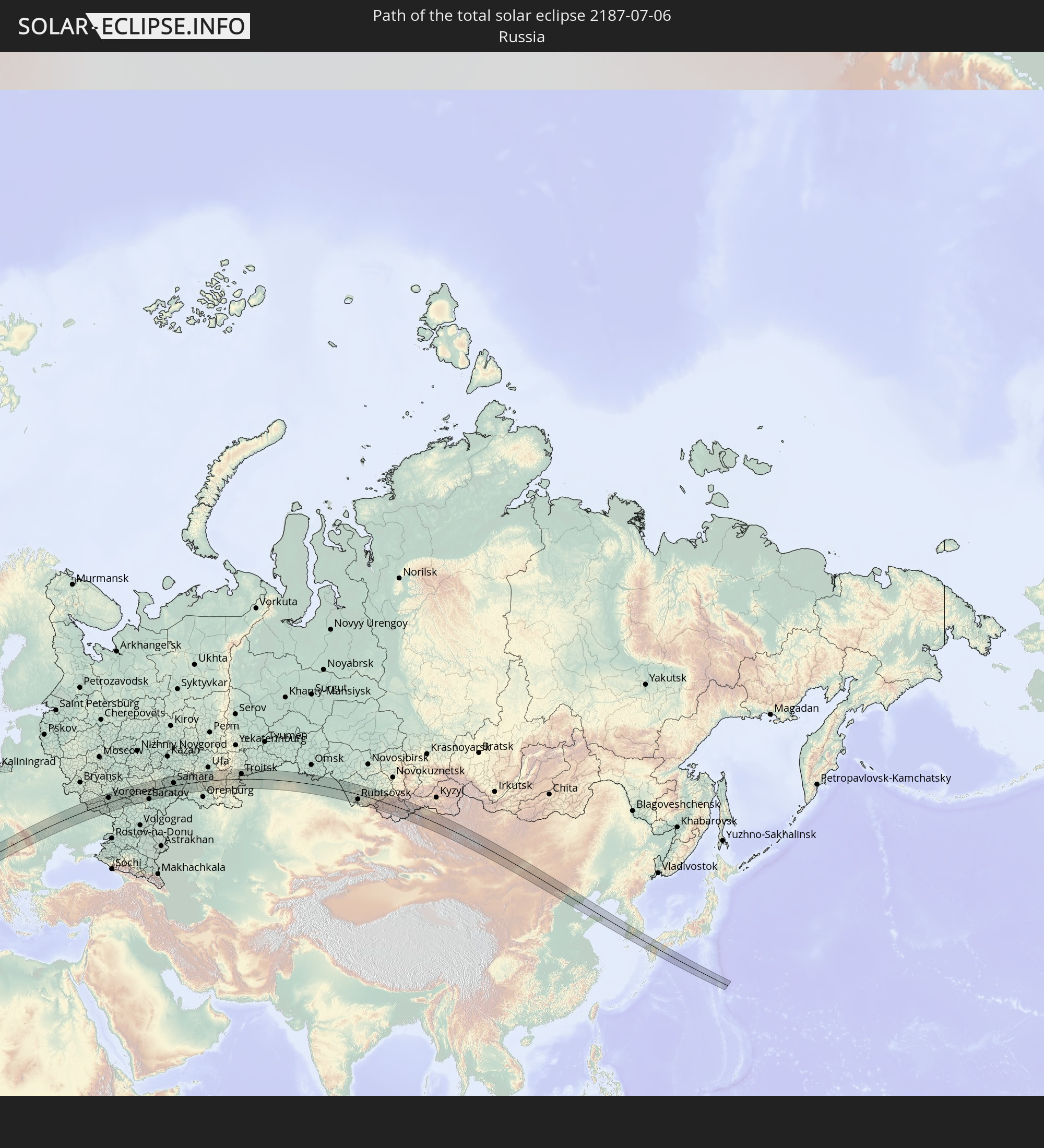 Russia
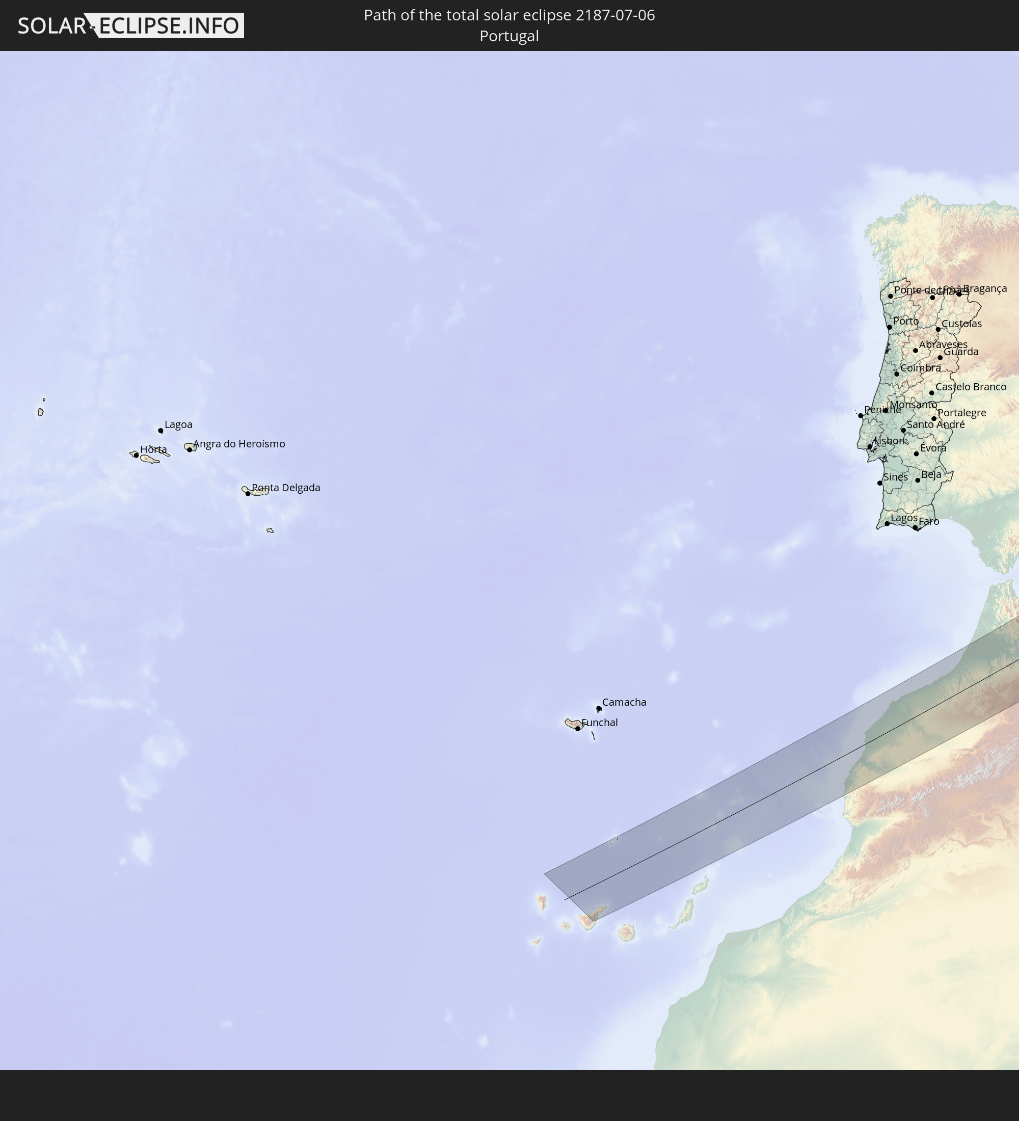 Portugal
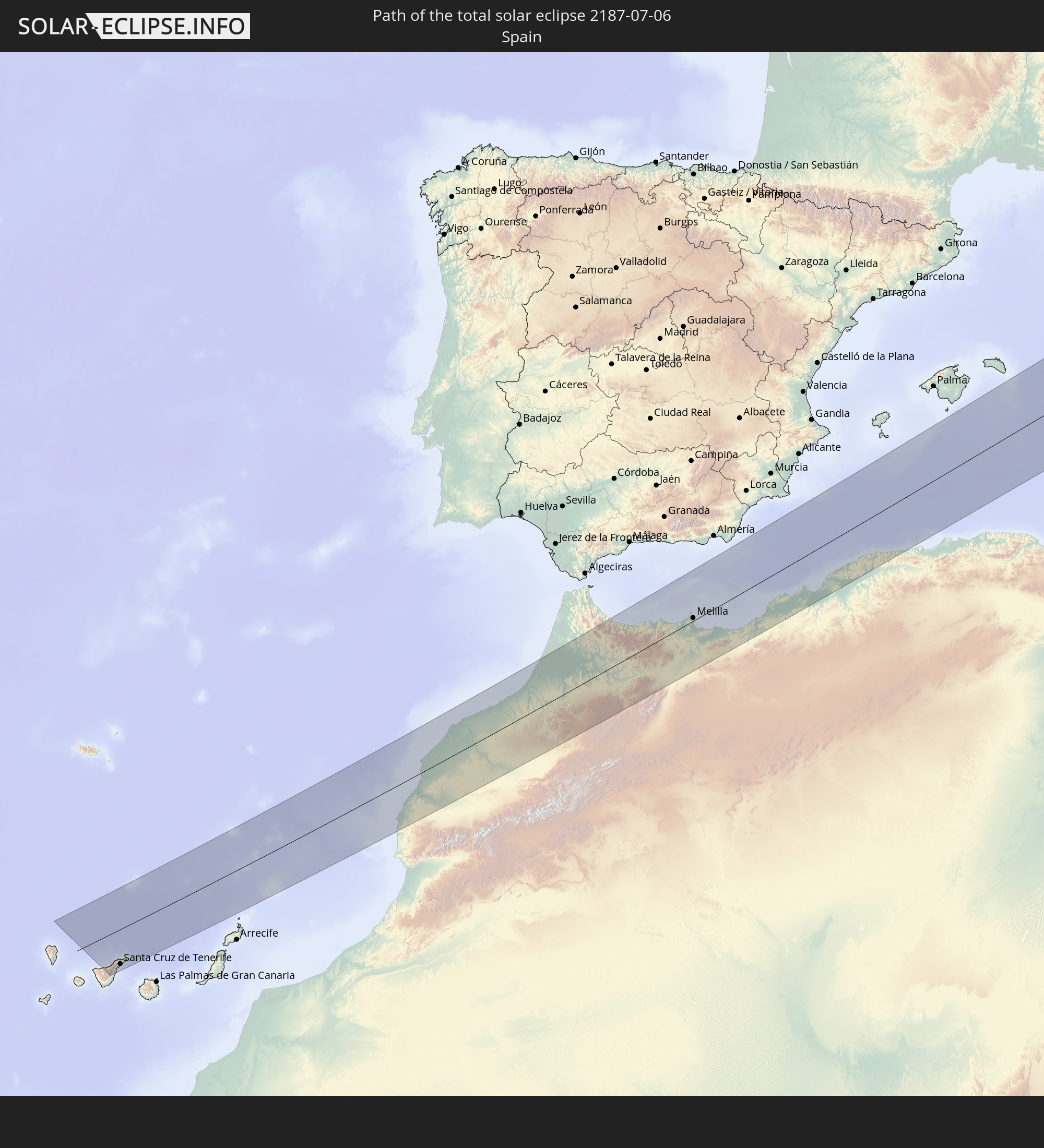 Spain
Spain
 Morocco
 Algeria
 France
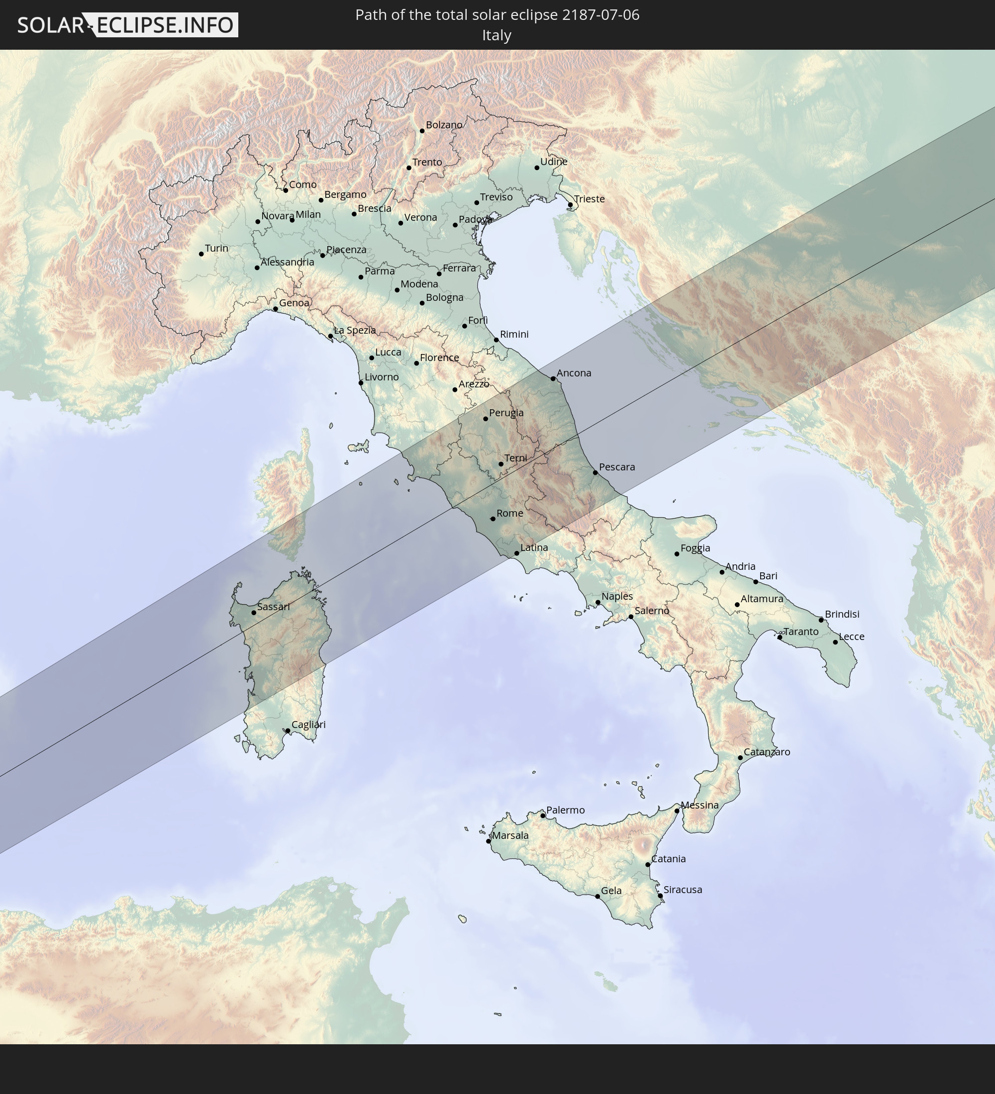 Italy
Italy
 Vatican City
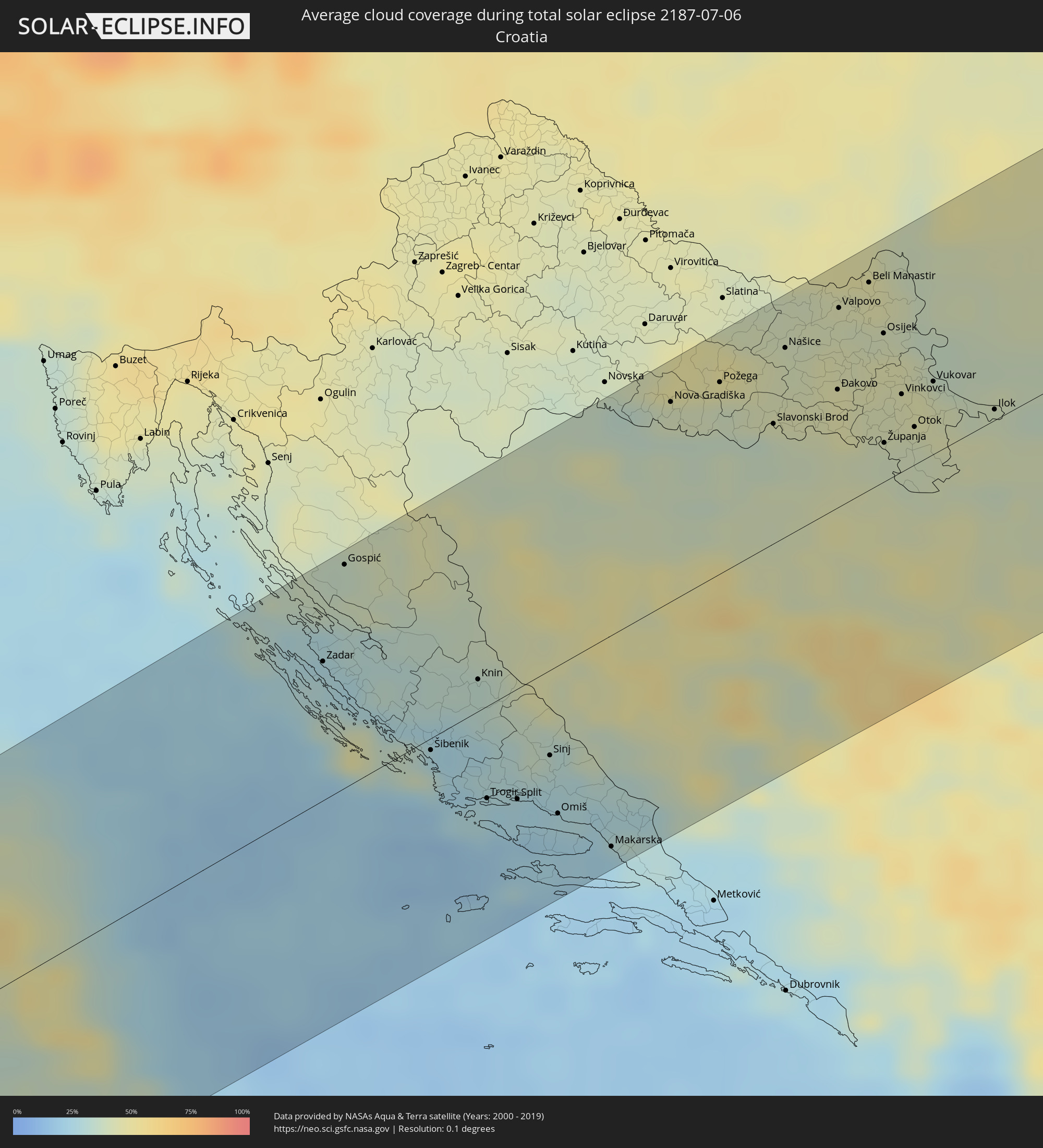
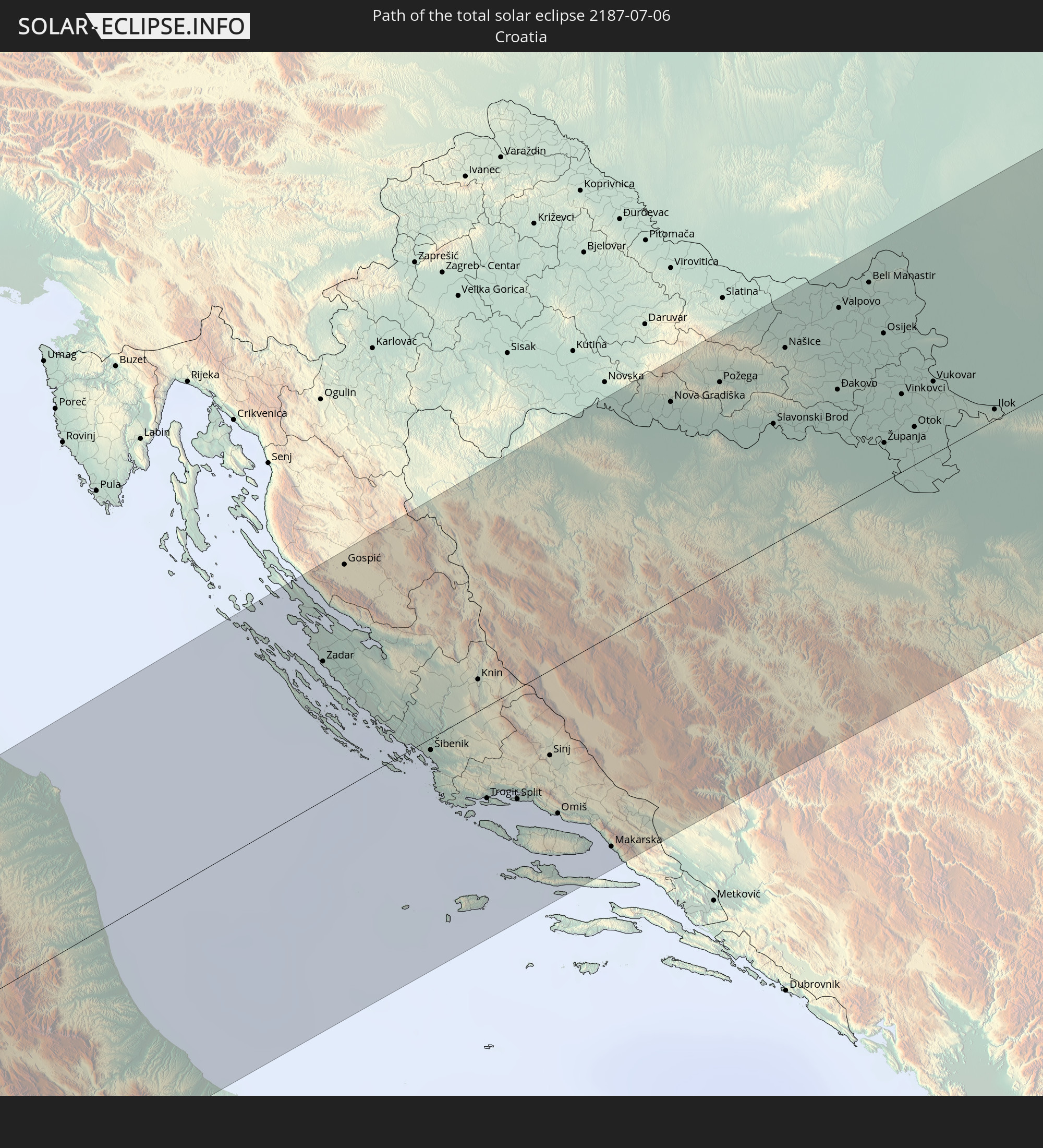 Croatia
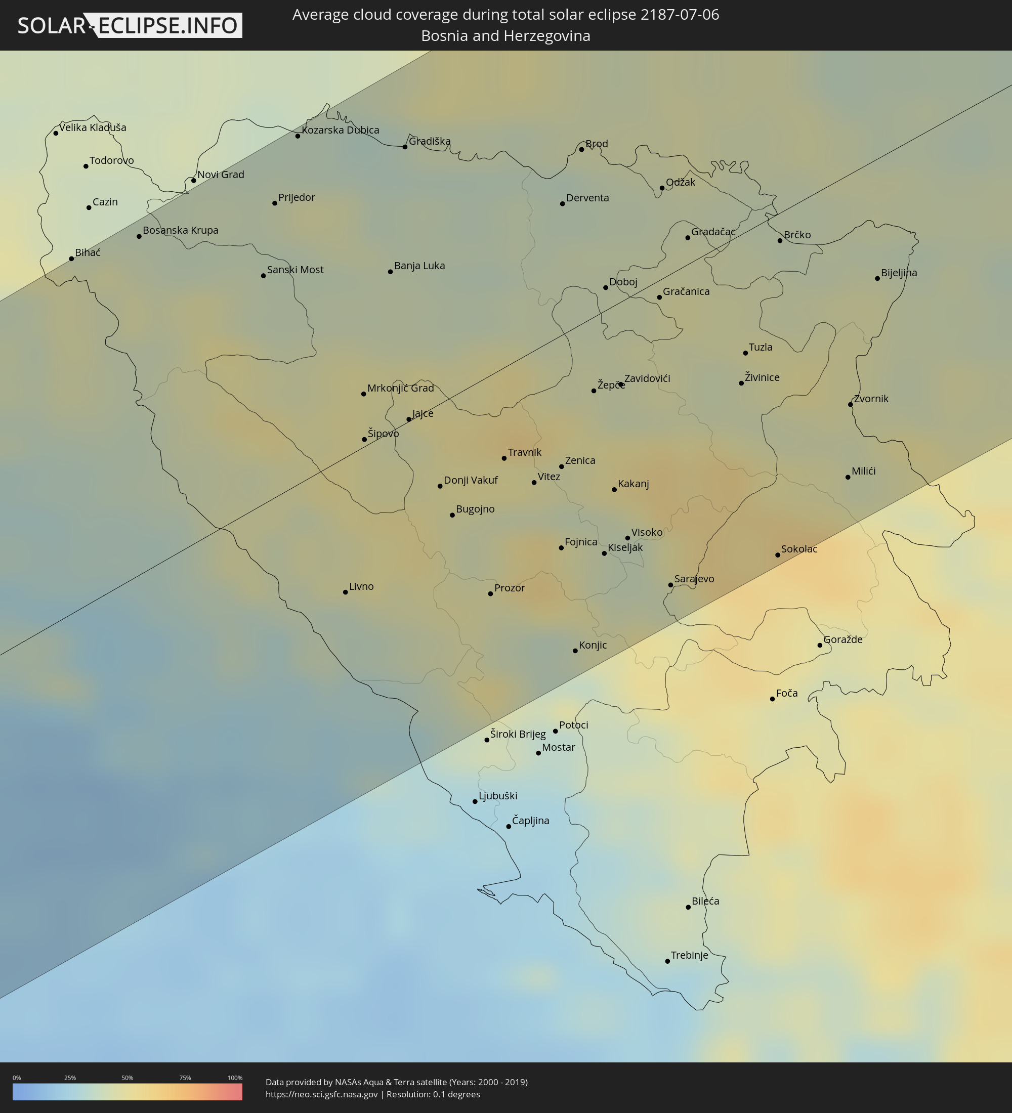
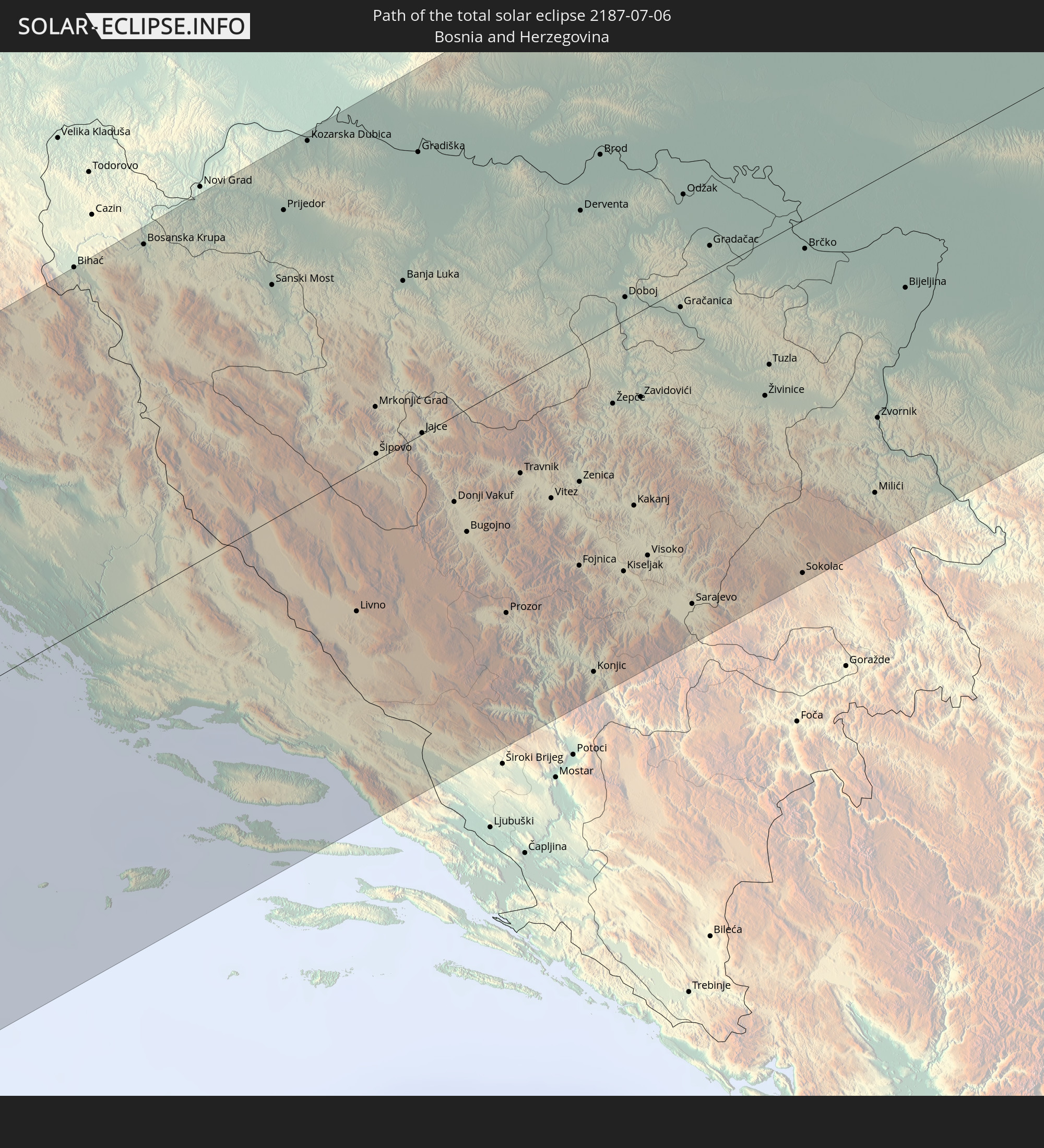 Bosnia and Herzegovina
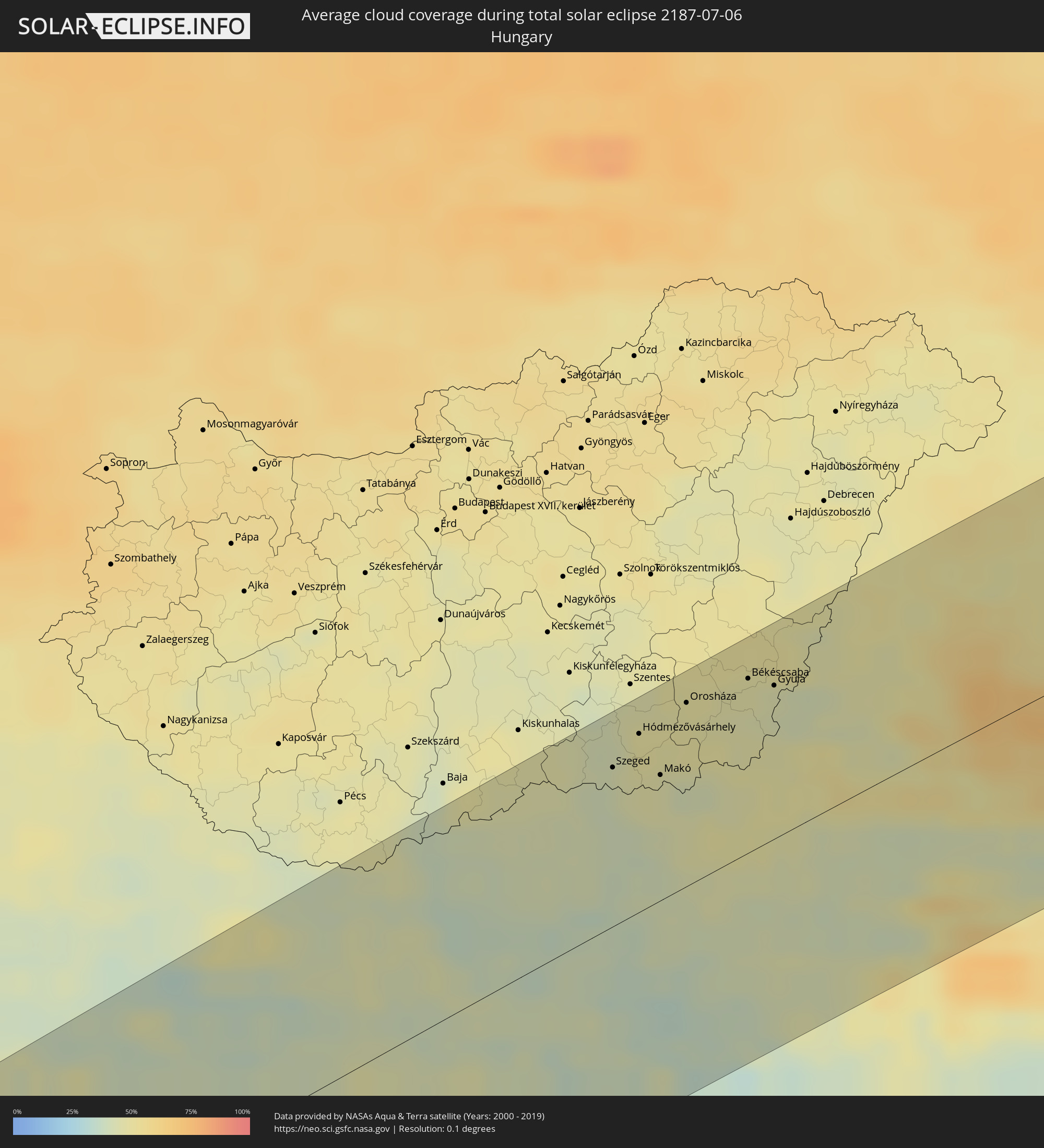
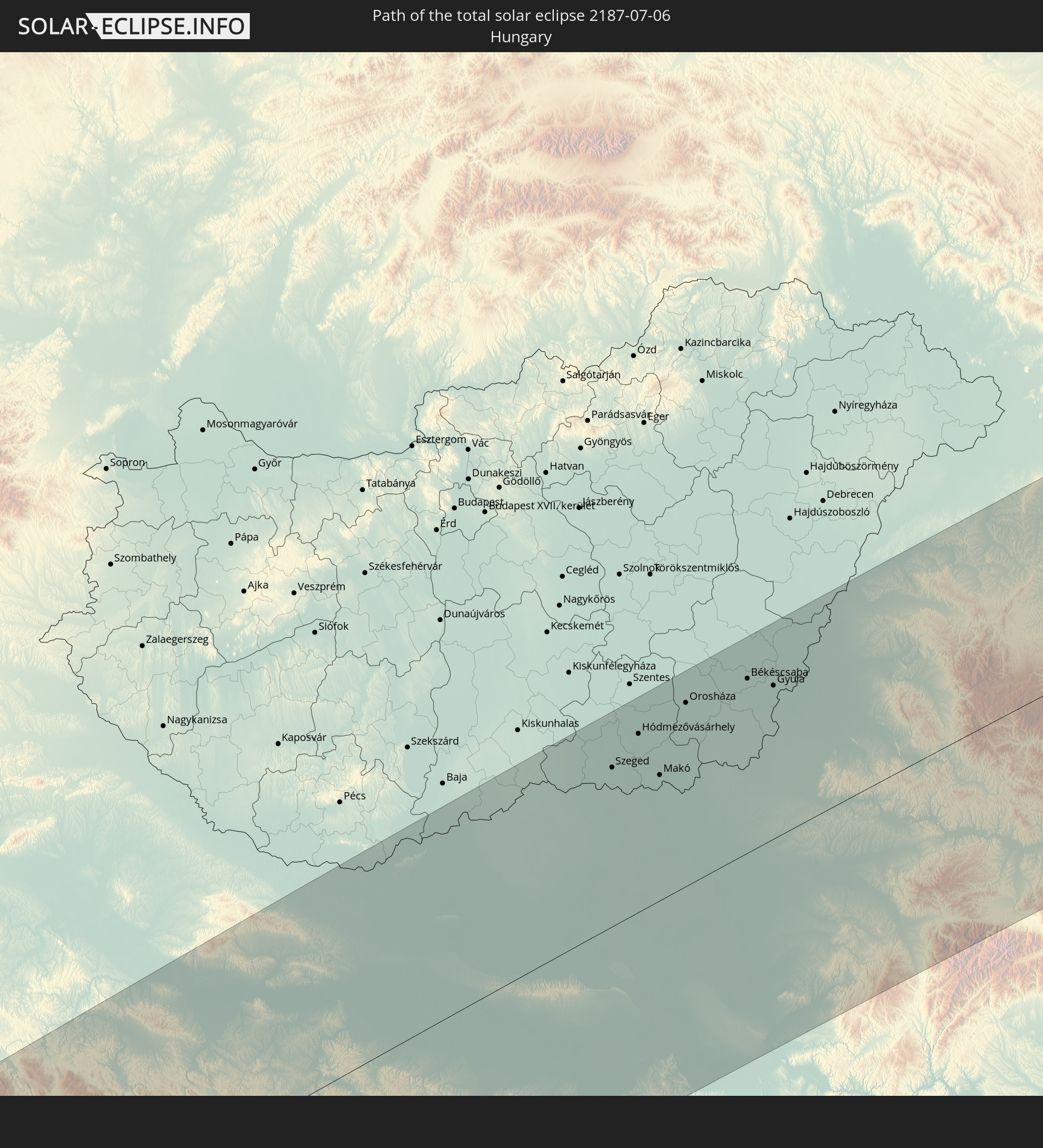 Hungary
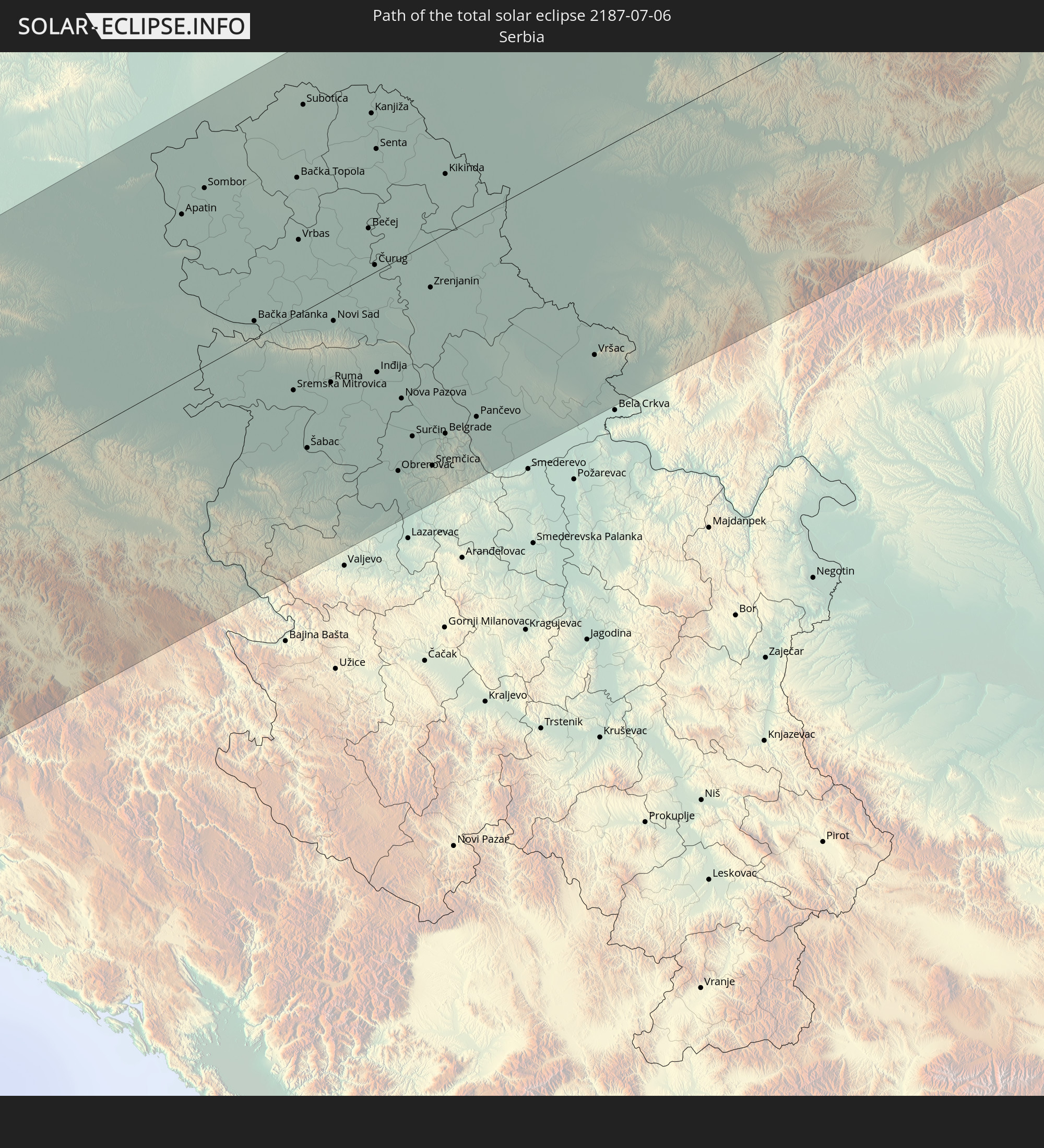 Serbia
 Romania
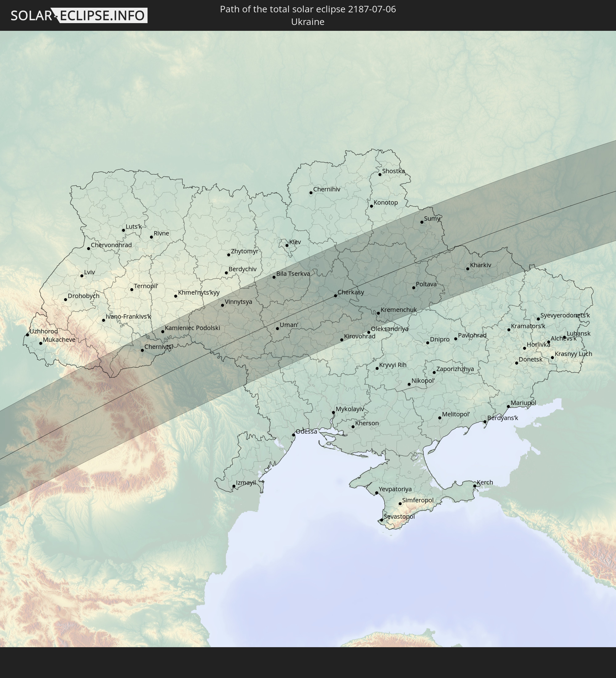 Ukraine
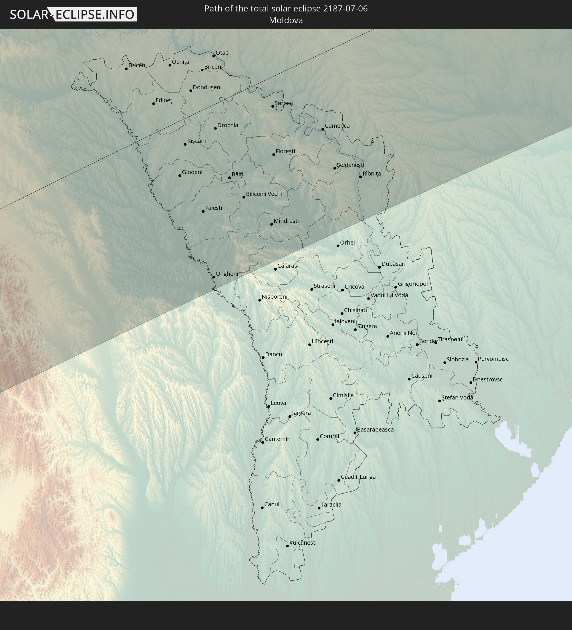 Moldova
 Kazakhstan
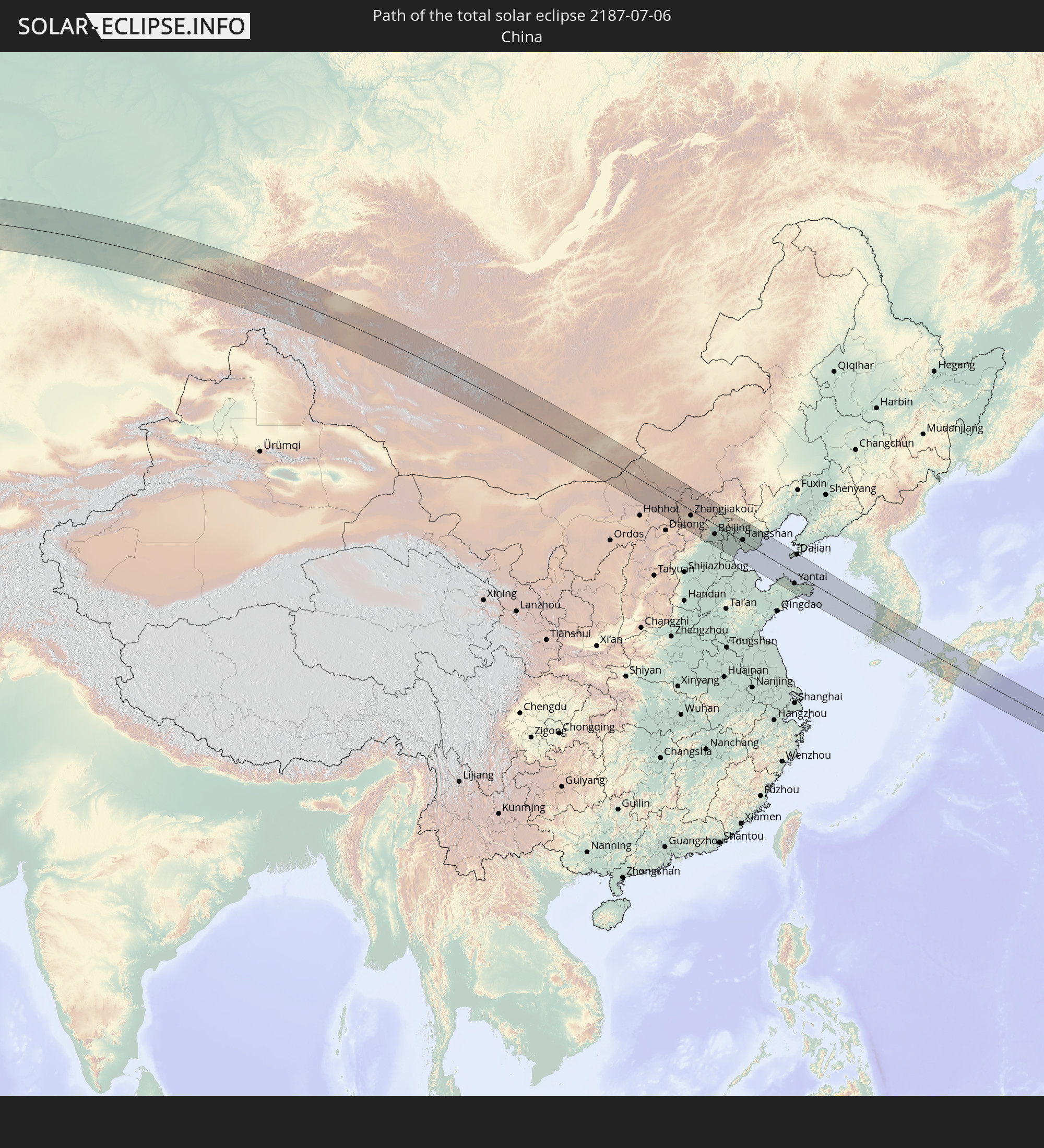 China
China
 Mongolia
 Japan
Japan
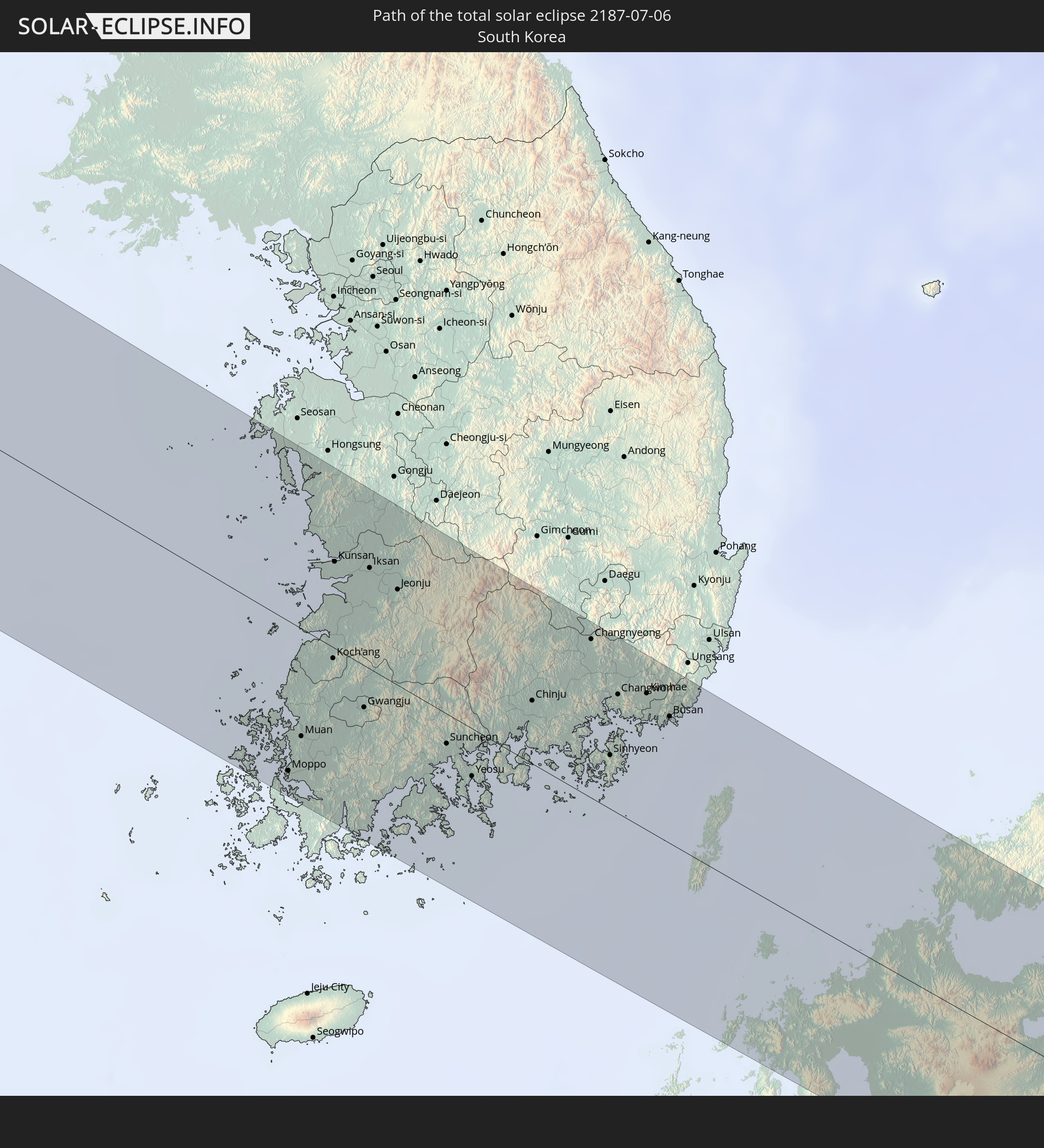 South Korea
In den folgenden Ländern ist die Sonnenfinsternis partiell zu sehen
 Russia
 United States
 Canada
 Greenland
 Portugal
 Iceland
 Spain
Spain
 Mauritania
 Morocco
 Mali
Mali
 Republic of Ireland
 Svalbard and Jan Mayen
 Algeria
 United Kingdom
 Ivory Coast
 Faroe Islands
 Burkina Faso
 Gibraltar
 France
 Isle of Man
 Ghana
Ghana
 Guernsey
 Jersey
 Togo
Togo
 Niger
Niger
 Benin
Benin
 Andorra
 Belgium
 Nigeria
 Netherlands
 Norway
 Equatorial Guinea
 Luxembourg
 Germany
 Switzerland
 Italy
Italy
 Monaco
 Tunisia
 Denmark
 Cameroon
 Libya
Libya
 Liechtenstein
 Austria
 Sweden
 Czechia
 San Marino
 Vatican City
 Slovenia
 Chad
Chad
 Croatia
 Poland
 Malta
Malta
 Central African Republic
 Bosnia and Herzegovina
 Hungary
 Slovakia
 Montenegro
 Serbia
 Albania
 Åland Islands
 Greece
 Romania
 Republic of Macedonia
 Finland
 Lithuania
 Latvia
 Estonia
 Sudan
Sudan
 Ukraine
 Bulgaria
 Belarus
 Egypt
Egypt
 Turkey
 Moldova
 Cyprus
 State of Palestine
 Israel
 Saudi Arabia
 Jordan
 Lebanon
 Syria
Syria
 Eritrea
 Iraq
Iraq
 Georgia
 Armenia
 Iran
Iran
 Azerbaijan
 Kazakhstan
 Kuwait
 Bahrain
 Qatar
Qatar
 United Arab Emirates
 Oman
Oman
 Turkmenistan
 Uzbekistan
 Afghanistan
 Pakistan
 Tajikistan
 India
India
 Kyrgyzstan
 China
China
 Nepal
Nepal
 Mongolia
 Bangladesh
 Bhutan
 Myanmar
 Indonesia
 Thailand
 Malaysia
 Laos
Laos
 Vietnam
 Cambodia
 Macau
Macau
 Hong Kong
 Brunei
 Taiwan
 Philippines
 Japan
Japan
 North Korea
 South Korea
How will be the weather during the total solar eclipse on 07/06/2187?
Where is the best place to see the total solar eclipse of 07/06/2187?
The following maps show the average cloud coverage for the day of the total solar eclipse.
With the help of these maps, it is possible to find the place along the eclipse path, which has the best
chance of a cloudless sky.
Nevertheless, you should consider local circumstances and inform about the weather of your chosen
observation site.
The data is provided by NASAs satellites
AQUA and TERRA.
The cloud maps are averaged over a period of 19 years (2000 - 2019).


Detailed country maps
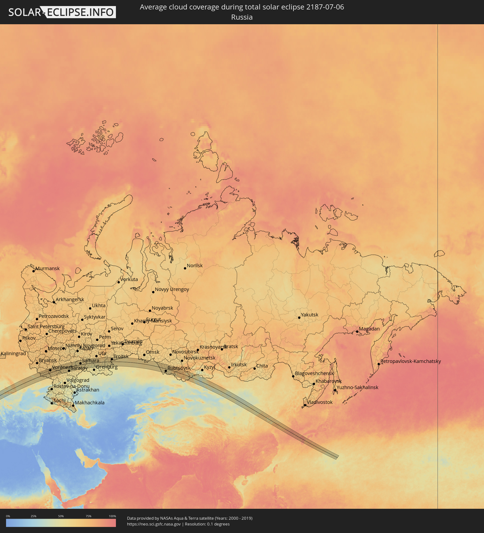 Russia
 Portugal
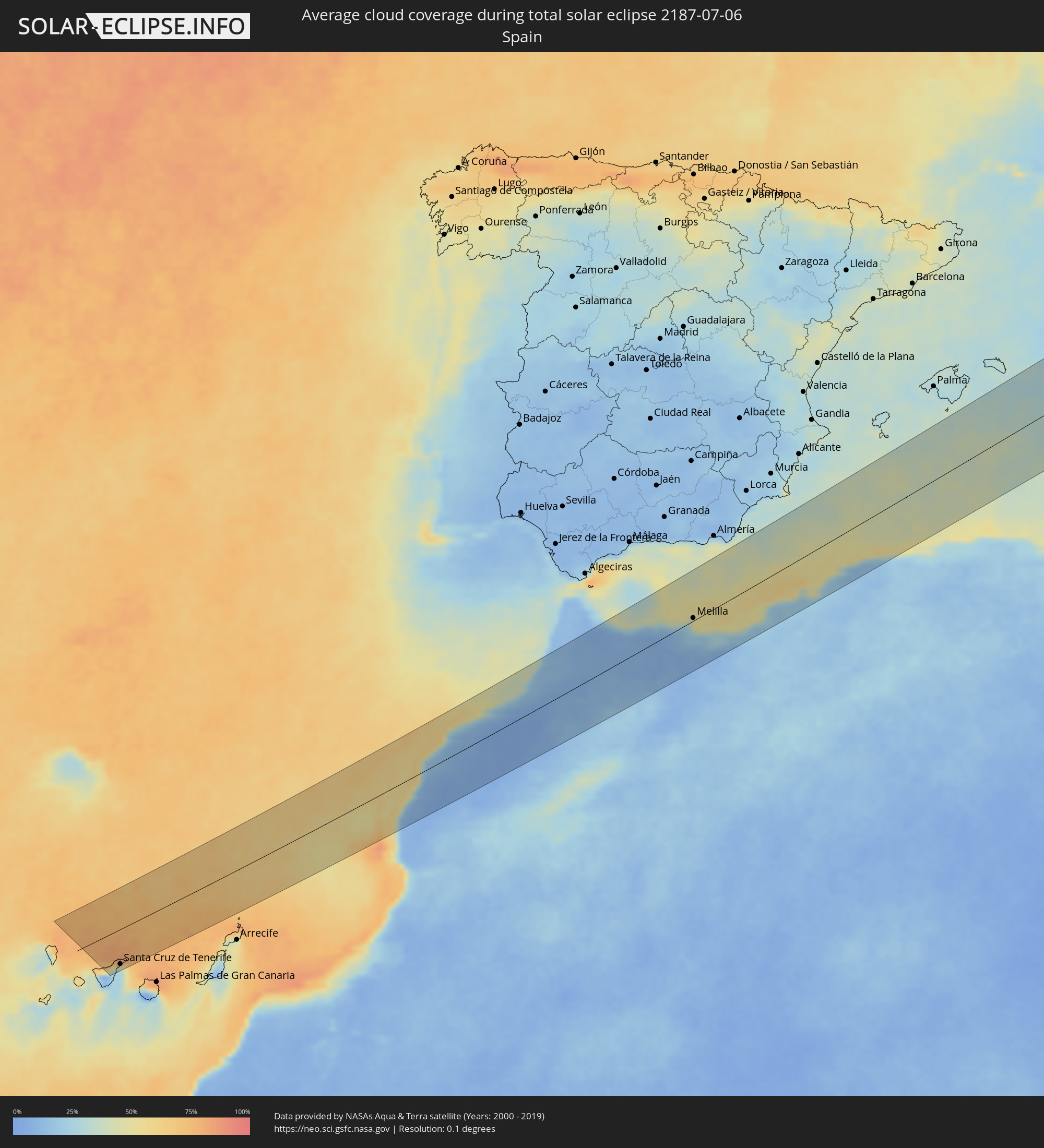 Spain
Spain
 Morocco
 Algeria
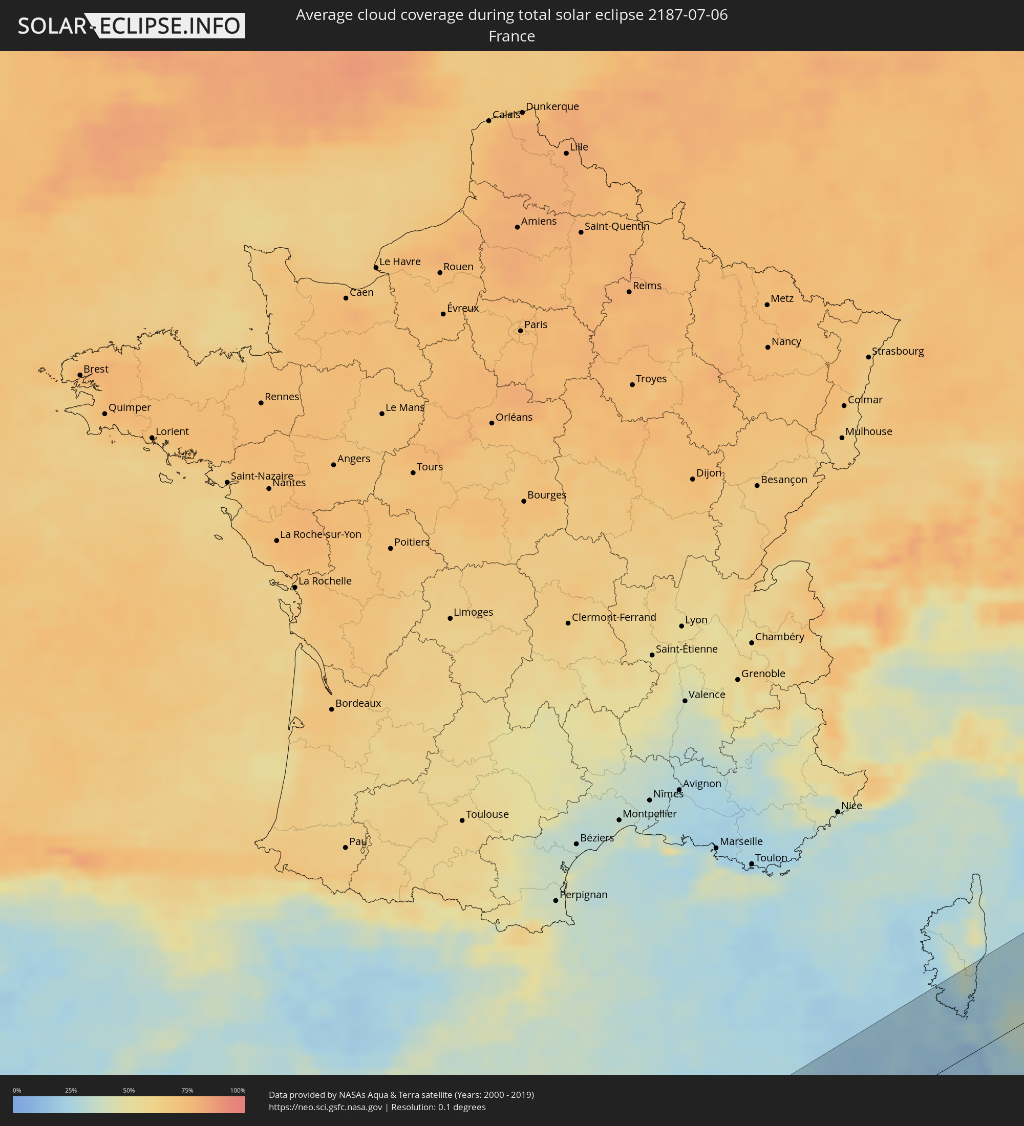 France
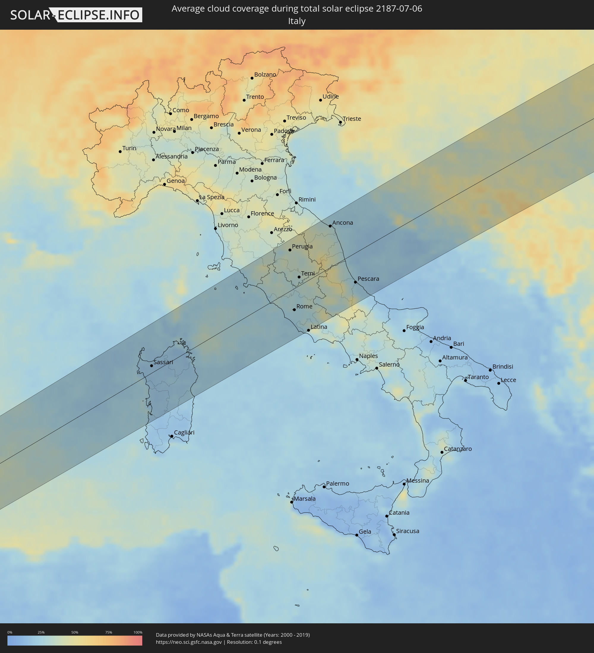 Italy
Italy
 Vatican City
 Croatia
 Bosnia and Herzegovina
 Hungary
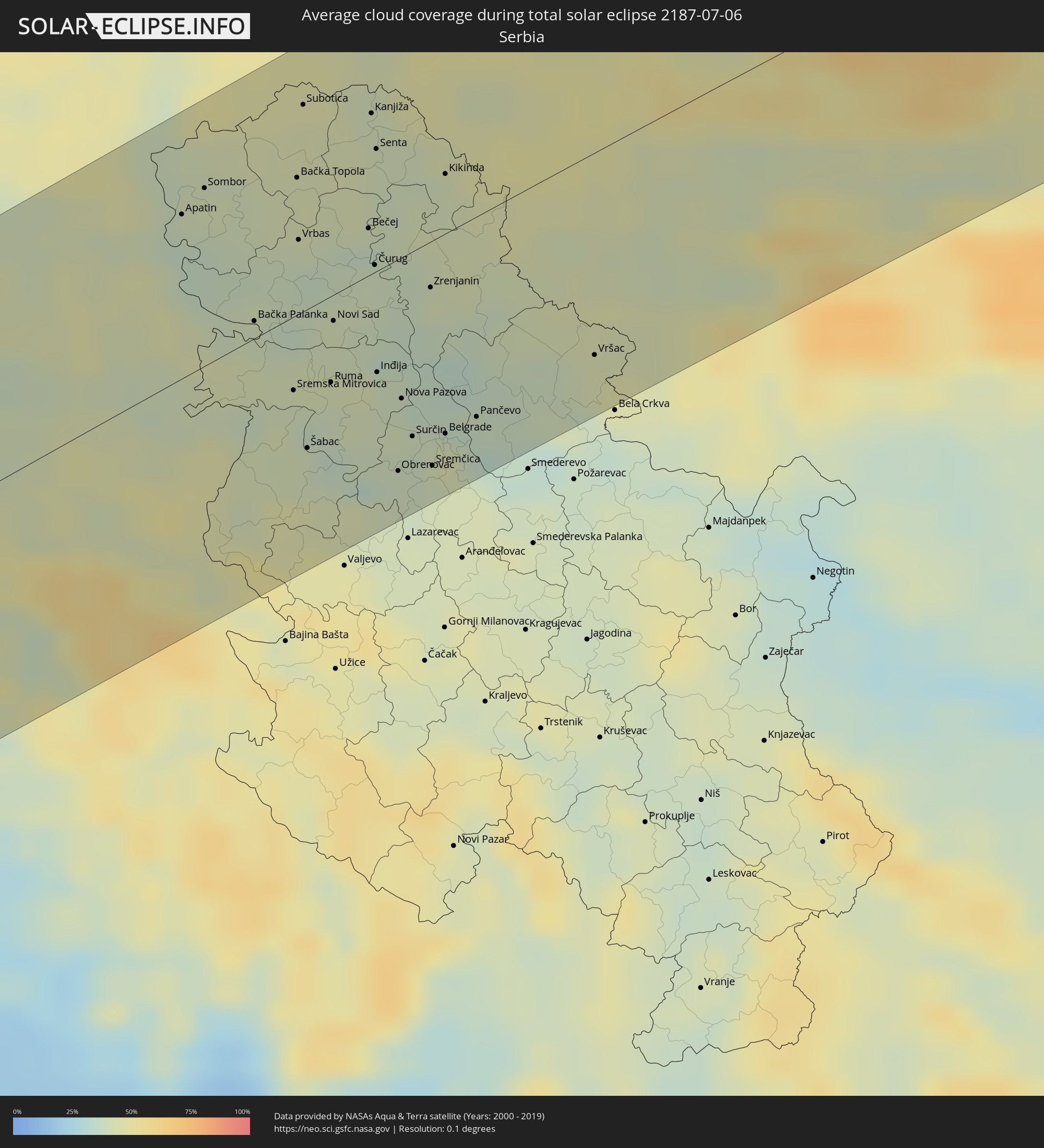 Serbia
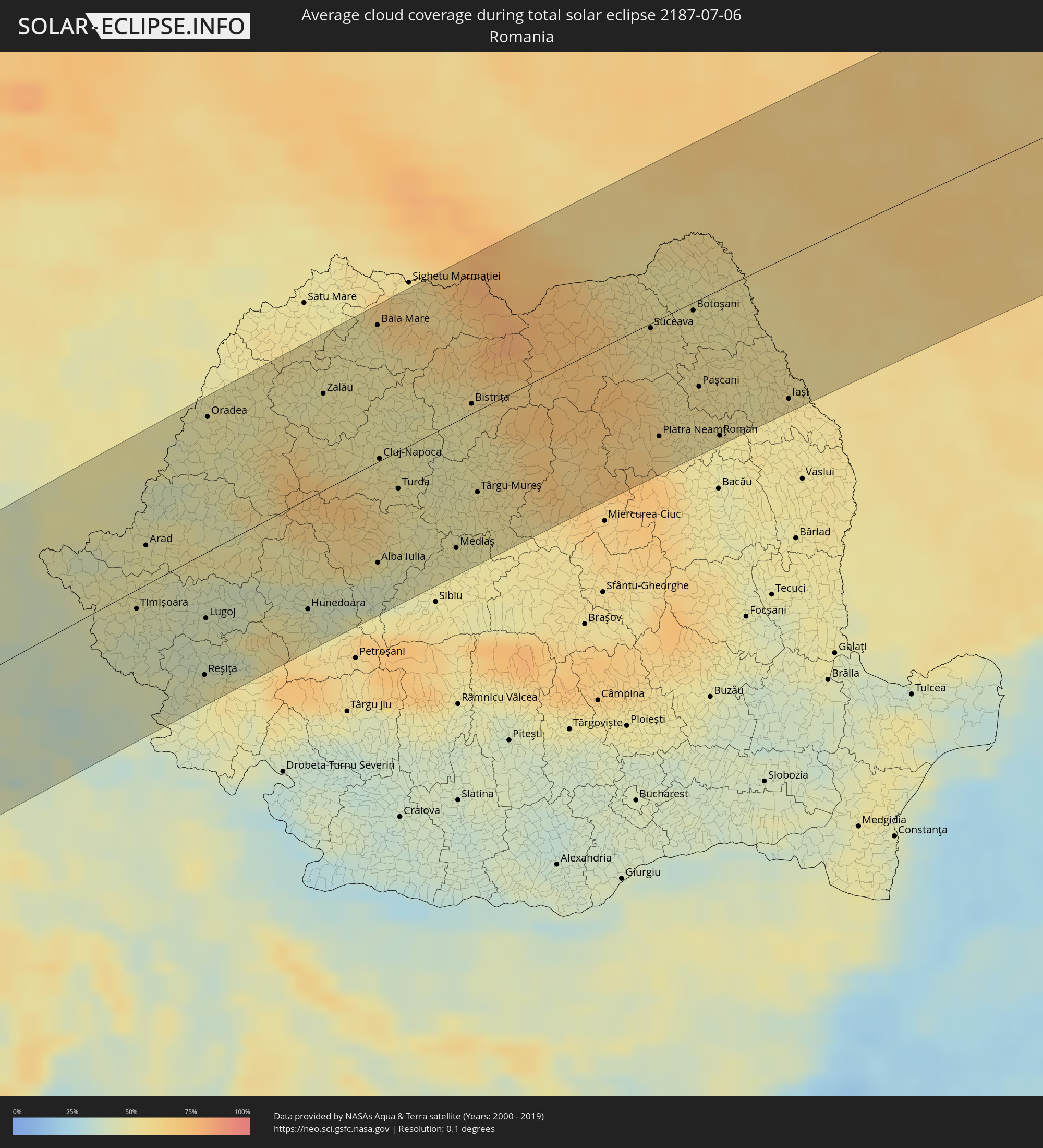 Romania
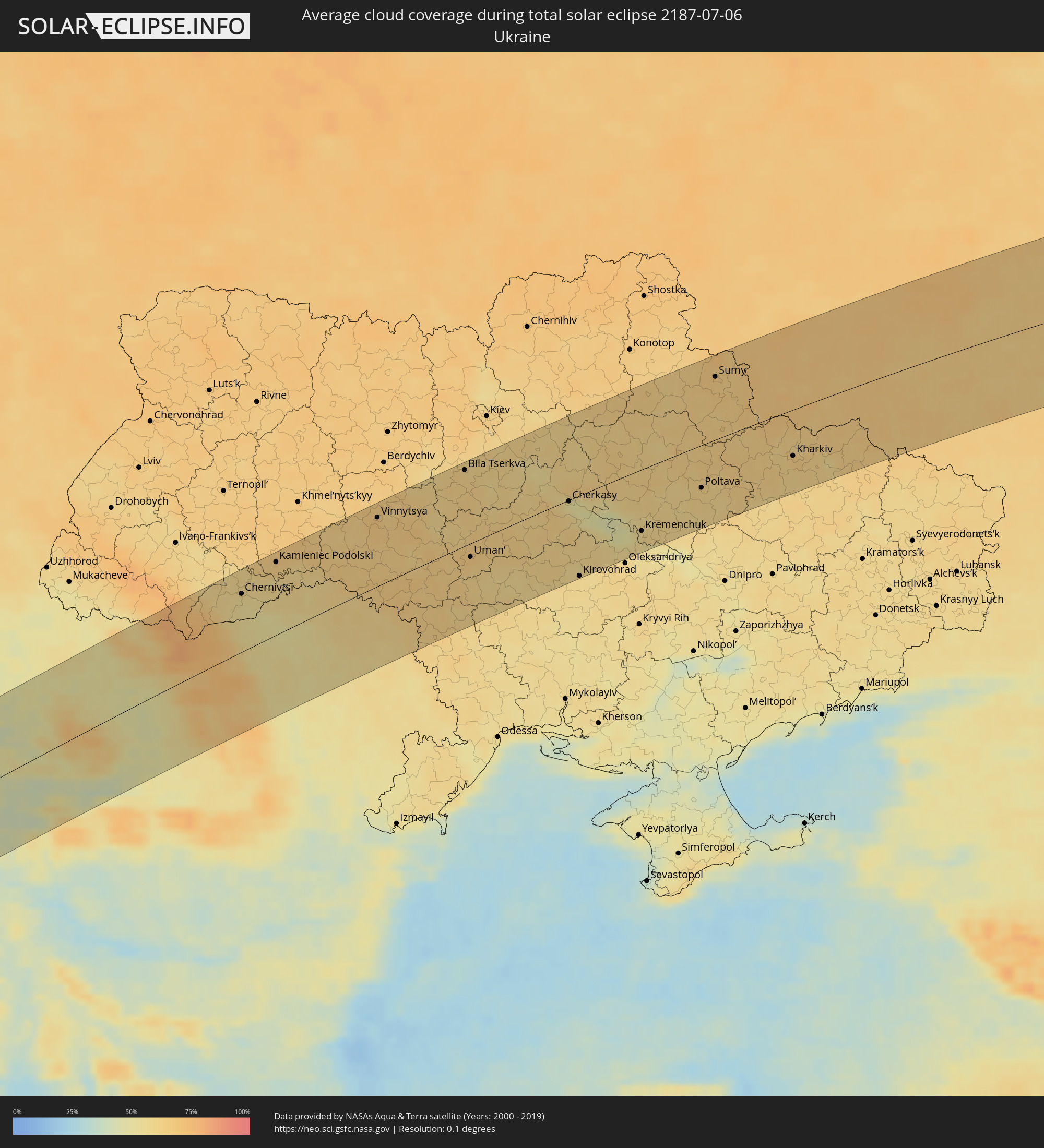 Ukraine
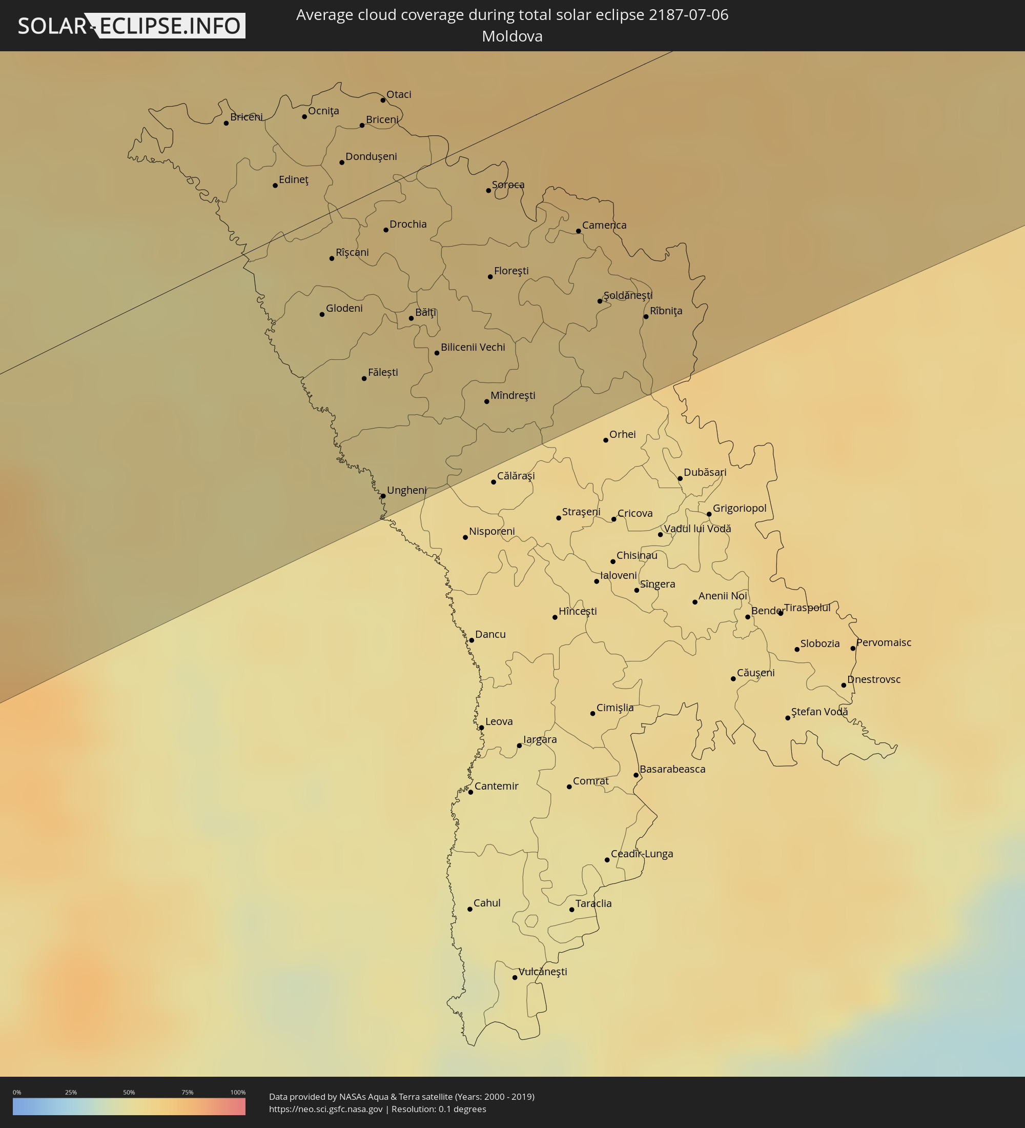 Moldova
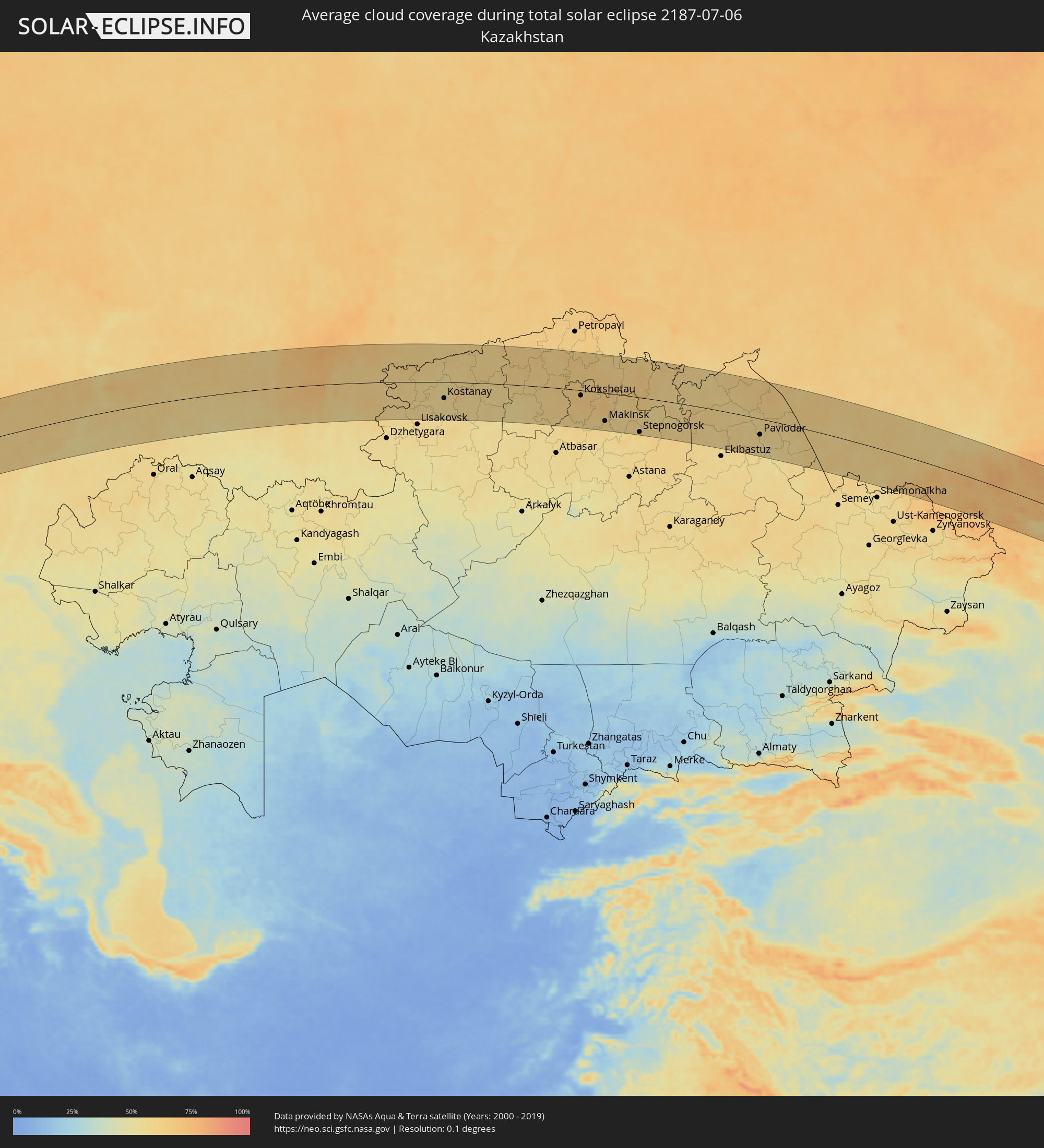 Kazakhstan
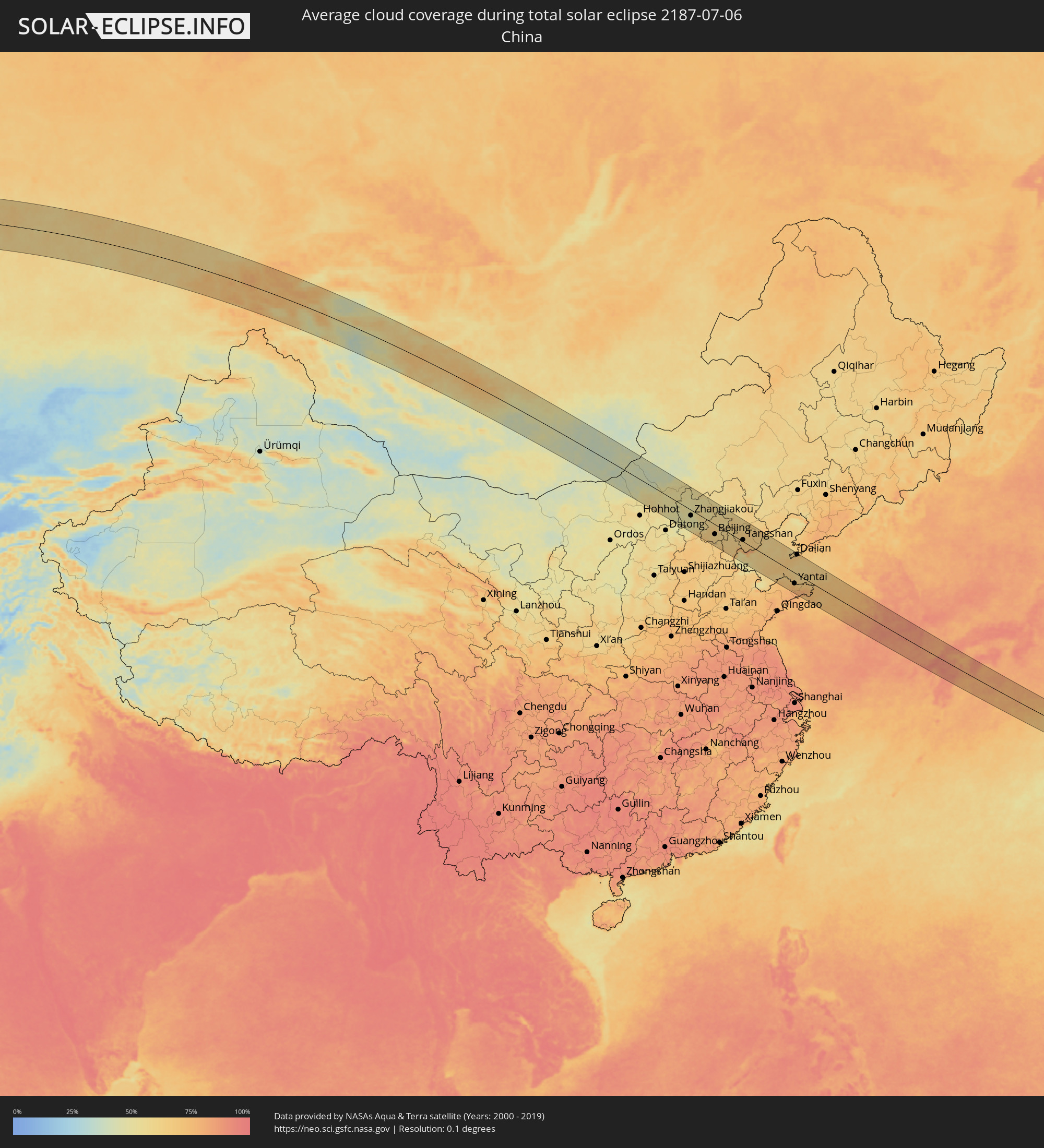 China
China
 Mongolia
 Japan
Japan
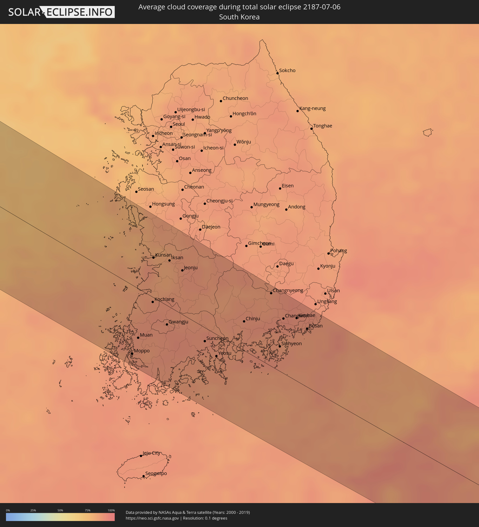 South Korea
Cities inside the path of the eclipse
The following table shows all locations with a population of more than 5,000 inside the eclipse path. Cities which have more than 100,000 inhabitants are marked bold. A click at the locations opens a detailed map.
| City | Type | Eclipse duration | Local time of max. eclipse | Distance to central line | Ø Cloud coverage |
|
La Orotava, Canary Islands
|
total | - | 06:20:44 UTC+00:00 | 70 km | 40% |
|
Santa Úrsula, Canary Islands
|
total | - | 06:20:45 UTC+00:00 | 69 km | 40% |
|
La Victoria de Acentejo, Canary Islands
|
total | - | 06:20:45 UTC+00:00 | 71 km | 40% |
|
La Matanza de Acentejo, Canary Islands
|
total | - | 06:20:46 UTC+00:00 | 69 km | 51% |
|
Sauzal, Canary Islands
|
total | - | 06:20:46 UTC+00:00 | 68 km | 51% |
|
Güimar, Canary Islands
|
total | - | 06:20:37 UTC+00:00 | 84 km | 24% |
|
Tacoronte, Canary Islands
|
total | - | 06:20:46 UTC+00:00 | 67 km | 51% |
|
Candelaria, Canary Islands
|
total | - | 06:20:39 UTC+00:00 | 81 km | 26% |
|
Tegueste, Canary Islands
|
total | - | 06:20:46 UTC+00:00 | 64 km | 36% |
|
Santa Cruz de Tenerife, Canary Islands
|
total | - | 06:20:42 UTC+00:00 | 71 km | 36% |
|
Safi, Doukkala-Abda
|
total | - | 07:22:32 UTC+01:00 | 2 km | 21% |
|
El Jadida, Doukkala-Abda
|
total | - | 07:23:28 UTC+01:00 | 63 km | 42% |
|
Casablanca, Grand Casablanca
|
total | - | 07:23:42 UTC+01:00 | 54 km | 24% |
|
Mohammedia, Grand Casablanca
|
total | - | 07:23:47 UTC+01:00 | 52 km | 24% |
|
Khouribga, Chaouia-Ouardigha
|
total | - | 07:22:47 UTC+01:00 | 53 km | 5% |
|
Rabat, Rabat-Salé-Zemmour-Zaër
|
total | - | 07:24:05 UTC+01:00 | 57 km | 18% |
|
Kenitra, Gharb-Chrarda-Beni Hssen
|
total | - | 07:24:21 UTC+01:00 | 73 km | 20% |
|
Meknès, Meknès-Tafilalet
|
total | - | 07:23:48 UTC+01:00 | 17 km | 10% |
|
Fes, Fès-Boulemane
|
total | - | 07:23:55 UTC+01:00 | 27 km | 11% |
|
Taza, Taza-Al Hoceima-Taounate
|
total | - | 07:24:03 UTC+01:00 | 56 km | 9% |
|
Al Hoceïma, Taza-Al Hoceima-Taounate
|
total | - | 07:25:19 UTC+01:00 | 50 km | 33% |
|
Melilla, Melilla
|
total | - | 07:25:20 UTC+01:00 | 11 km | 49% |
|
Nedroma, Tlemcen
|
total | - | 07:24:58 UTC+01:00 | 78 km | 17% |
|
Remchi, Tlemcen
|
total | - | 07:25:02 UTC+01:00 | 86 km | 19% |
|
Beni Saf, Aïn Témouchent
|
total | - | 07:25:20 UTC+01:00 | 69 km | 28% |
|
Aïn Temouchent, Aïn Témouchent
|
total | - | 07:25:20 UTC+01:00 | 76 km | 21% |
|
Hammam Bou Hadjar, Aïn Témouchent
|
total | - | 07:25:26 UTC+01:00 | 77 km | 20% |
|
Oran, Oran
|
total | - | 07:25:51 UTC+01:00 | 60 km | 22% |
|
Sidi ech Chahmi, Oran
|
total | - | 07:25:48 UTC+01:00 | 70 km | 20% |
|
Aïn el Bya, Oran
|
total | - | 07:26:00 UTC+01:00 | 67 km | 22% |
|
Mostaganem, Mostaganem
|
total | - | 07:26:11 UTC+01:00 | 73 km | 24% |
|
’Aïn Merane, Relizane
|
total | - | 07:26:33 UTC+01:00 | 88 km | 14% |
|
Sidi Akkacha, Chlef
|
total | - | 07:26:58 UTC+01:00 | 74 km | 23% |
|
Sassari, Sardinia
|
total | - | 07:34:27 UTC+01:00 | 19 km | 18% |
|
Porto-Vecchio, Corsica
|
total | - | 07:35:58 UTC+01:00 | 65 km | 19% |
|
Grosseto, Tuscany
|
total | - | 07:38:26 UTC+01:00 | 102 km | 26% |
|
Acilia-Castel Fusano-Ostia Antica, Latium
|
total | - | 07:37:29 UTC+01:00 | 48 km | 21% |
|
Perugia, Umbria
|
total | - | 07:39:31 UTC+01:00 | 79 km | 35% |
|
Vatican City
|
total | - | 07:37:45 UTC+01:00 | 39 km | 25% |
|
Rome, Latium
|
total | - | 07:37:45 UTC+01:00 | 43 km | 25% |
|
Terni, Umbria
|
total | - | 07:38:49 UTC+01:00 | 16 km | 30% |
|
Foligno, Umbria
|
total | - | 07:39:26 UTC+01:00 | 51 km | 32% |
|
Guidonia Montecelio, Latium
|
total | - | 07:38:00 UTC+01:00 | 42 km | 25% |
|
Velletri, Latium
|
total | - | 07:37:34 UTC+01:00 | 74 km | 31% |
|
Ancona, The Marches
|
total | - | 07:40:48 UTC+01:00 | 79 km | 32% |
|
Pescara, Abruzzo
|
total | - | 07:39:26 UTC+01:00 | 58 km | 24% |
|
Zadar, Zadarska
|
total | - | 07:42:31 UTC+01:00 | 59 km | 29% |
|
Bihać, Federation of Bosnia and Herzegovina
|
total | - | 07:43:56 UTC+01:00 | 101 km | 44% |
|
Šibenik, Šibensko-Kniniska
|
total | - | 07:42:18 UTC+01:00 | 13 km | 34% |
|
Split, Splitsko-Dalmatinska
|
total | - | 07:42:17 UTC+01:00 | 49 km | 26% |
|
Prijedor, Republic of Srspka
|
total | - | 07:44:41 UTC+01:00 | 87 km | 38% |
|
Makarska, Splitsko-Dalmatinska
|
total | - | 07:42:19 UTC+01:00 | 91 km | 23% |
|
Banja Luka, Republic of Srspka
|
total | - | 07:44:41 UTC+01:00 | 46 km | 41% |
|
Bugojno, Federation of Bosnia and Herzegovina
|
total | - | 07:43:44 UTC+01:00 | 41 km | 42% |
|
Travnik, Federation of Bosnia and Herzegovina
|
total | - | 07:44:08 UTC+01:00 | 26 km | 43% |
|
Požega, Požeško-Slavonska
|
total | - | 07:45:51 UTC+01:00 | 81 km | 39% |
|
Zenica, Federation of Bosnia and Herzegovina
|
total | - | 07:44:15 UTC+01:00 | 38 km | 40% |
|
Slavonski Brod, Slavonski Brod-Posavina
|
total | - | 07:45:47 UTC+01:00 | 51 km | 38% |
|
Doboj, Republic of Srspka
|
total | - | 07:45:11 UTC+01:00 | 6 km | 43% |
|
Sarajevo, Federation of Bosnia and Herzegovina
|
total | - | 07:44:01 UTC+01:00 | 90 km | 48% |
|
Đakovo, Osječko-Baranjska
|
total | - | 07:46:16 UTC+01:00 | 50 km | 46% |
|
Tuzla, Federation of Bosnia and Herzegovina
|
total | - | 07:45:16 UTC+01:00 | 35 km | 42% |
|
Osijek, Osječko-Baranjska
|
total | - | 07:46:50 UTC+01:00 | 62 km | 42% |
|
Županja, Vukovar-Sirmium
|
total | - | 07:46:06 UTC+01:00 | 16 km | 39% |
|
Vinkovci, Vukovar-Sirmium
|
total | - | 07:46:30 UTC+01:00 | 33 km | 44% |
|
Brčko, Brčko
|
total | - | 07:45:52 UTC+01:00 | 8 km | 42% |
|
Vukovar, Vukovar-Sirmium
|
total | - | 07:46:43 UTC+01:00 | 31 km | 43% |
|
Sombor, Vojvodina
|
total | - | 07:47:27 UTC+01:00 | 68 km | 41% |
|
Bijeljina, Republic of Srspka
|
total | - | 07:45:58 UTC+01:00 | 34 km | 45% |
|
Bácsalmás, Bács-Kiskun
|
total | - | 07:48:09 UTC+01:00 | 94 km | 45% |
|
Sremska Mitrovica, Vojvodina
|
total | - | 07:46:35 UTC+01:00 | 28 km | 40% |
|
Subotica, Vojvodina
|
total | - | 07:48:20 UTC+01:00 | 79 km | 43% |
|
Šabac, Central Serbia
|
total | - | 07:46:17 UTC+01:00 | 54 km | 40% |
|
Ruma, Vojvodina
|
total | - | 07:46:47 UTC+01:00 | 33 km | 39% |
|
Novi Sad, Vojvodina
|
total | - | 07:47:10 UTC+01:00 | 10 km | 41% |
|
Szeged, Csongrád
|
total | - | 07:48:55 UTC+01:00 | 77 km | 43% |
|
Mindszent, Csongrád
|
total | - | 07:49:21 UTC+01:00 | 102 km | 45% |
|
Hódmezővásárhely, Csongrád
|
total | - | 07:49:18 UTC+01:00 | 86 km | 48% |
|
Zrenjanin, Vojvodina
|
total | - | 07:47:45 UTC+01:00 | 27 km | 42% |
|
Belgrade, Central Serbia
|
total | - | 07:46:56 UTC+01:00 | 77 km | 43% |
|
Kikinda, Vojvodina
|
total | - | 07:48:30 UTC+01:00 | 25 km | 41% |
|
Makó, Csongrád
|
total | - | 07:49:06 UTC+01:00 | 61 km | 45% |
|
Pančevo, Vojvodina
|
total | - | 07:47:10 UTC+01:00 | 77 km | 36% |
|
Orosháza, Bekes
|
total | - | 07:49:46 UTC+01:00 | 89 km | 48% |
|
Mezőkovácsháza, Bekes
|
total | - | 07:49:42 UTC+01:00 | 62 km | 48% |
|
Mezőberény, Bekes
|
total | - | 07:50:25 UTC+01:00 | 98 km | 48% |
|
Békéscsaba, Bekes
|
total | - | 07:50:16 UTC+01:00 | 83 km | 47% |
|
Timişoara, Timiş
|
total | - | 08:48:57 UTC+02:00 | 18 km | 45% |
|
Vésztő, Bekes
|
total | - | 07:50:45 UTC+01:00 | 100 km | 50% |
|
Vršac, Vojvodina
|
total | - | 07:48:02 UTC+01:00 | 80 km | 43% |
|
Arad, Arad
|
total | - | 08:49:40 UTC+02:00 | 26 km | 48% |
|
Sarkad, Bekes
|
total | - | 07:50:35 UTC+01:00 | 79 km | 50% |
|
Oradea, Bihor
|
total | - | 08:51:26 UTC+02:00 | 89 km | 50% |
|
Baia Mare, Satu Mare
|
total | - | 08:53:41 UTC+02:00 | 90 km | 59% |
|
Cluj-Napoca, Cluj
|
total | - | 08:52:22 UTC+02:00 | 9 km | 51% |
|
Bistriţa, Bistriţa-Năsăud
|
total | - | 08:53:40 UTC+02:00 | 7 km | 52% |
|
Târgu-Mureş, Mureş
|
total | - | 08:52:50 UTC+02:00 | 58 km | 54% |
|
Chernivtsi, Chernivtsi
|
total | - | 08:56:39 UTC+02:00 | 73 km | 56% |
|
Suceava, Suceava
|
total | - | 08:55:58 UTC+02:00 | 20 km | 54% |
|
Piatra Neamţ, Neamţ
|
total | - | 08:54:59 UTC+02:00 | 78 km | 62% |
|
Kamieniec Podolski, Khmelnytskyi
|
total | - | 08:57:49 UTC+02:00 | 91 km | 64% |
|
Botoşani, Botoşani
|
total | - | 08:56:31 UTC+02:00 | 12 km | 51% |
|
Edineţ, Raionul Edineţ
|
total | - | 08:57:44 UTC+02:00 | 18 km | 58% |
|
Rîşcani, Rîşcani
|
total | - | 08:57:39 UTC+02:00 | 15 km | 57% |
|
Iaşi, Iaşi
|
total | - | 08:56:32 UTC+02:00 | 94 km | 55% |
|
Briceni, Donduşeni
|
total | - | 08:58:22 UTC+02:00 | 26 km | 62% |
|
Fălești, Făleşti
|
total | - | 08:57:15 UTC+02:00 | 58 km | 55% |
|
Ungheni, Ungheni
|
total | - | 08:56:48 UTC+02:00 | 99 km | 55% |
|
Drochia, Drochia
|
total | - | 08:58:01 UTC+02:00 | 24 km | 59% |
|
Bălţi, Bălţi
|
total | - | 08:57:43 UTC+02:00 | 47 km | 59% |
|
Sîngerei, Sîngerei
|
total | - | 08:57:45 UTC+02:00 | 67 km | 56% |
|
Soroca, Raionul Soroca
|
total | - | 08:58:38 UTC+02:00 | 23 km | 60% |
|
Floreşti, Floreşti
|
total | - | 08:58:16 UTC+02:00 | 44 km | 59% |
|
Vinnytsya, Vinnyts'ka
|
total | - | 09:00:23 UTC+02:00 | 85 km | 66% |
|
Rîbniţa, Stînga Nistrului
|
total | - | 08:58:48 UTC+02:00 | 79 km | 60% |
|
Bila Tserkva, Kiev
|
total | - | 09:02:49 UTC+02:00 | 95 km | 62% |
|
Uman’, Cherkasy
|
total | - | 09:01:25 UTC+02:00 | 20 km | 63% |
|
Cherkasy, Cherkasy
|
total | - | 09:04:18 UTC+02:00 | 4 km | 55% |
|
Kirovohrad, Kirovohrad
|
total | - | 09:03:15 UTC+02:00 | 102 km | 57% |
|
Kremenchuk, Poltava
|
total | - | 09:05:18 UTC+02:00 | 77 km | 57% |
|
Poltava, Poltava
|
total | - | 09:07:16 UTC+02:00 | 56 km | 62% |
|
Sumy, Sumy
|
total | - | 09:09:18 UTC+02:00 | 79 km | 65% |
|
Kharkiv, Kharkiv
|
total | - | 09:09:46 UTC+02:00 | 57 km | 65% |
|
Belgorod, Belgorod
|
total | - | 10:10:57 UTC+03:00 | 6 km | 66% |
|
Staryy Oskol, Belgorod
|
total | - | 10:13:18 UTC+03:00 | 42 km | 68% |
|
Voronezh, Voronezj
|
total | - | 10:15:22 UTC+03:00 | 51 km | 70% |
|
Penza, Penza
|
total | - | 10:24:21 UTC+03:00 | 101 km | 69% |
|
Saratov, Saratov
|
total | - | 11:24:12 UTC+04:00 | 96 km | 58% |
|
Balakovo, Saratov
|
total | - | 11:27:09 UTC+04:00 | 70 km | 57% |
|
Syzran’, Samara
|
total | - | 11:28:59 UTC+04:00 | 45 km | 62% |
|
Tol’yatti, Samara
|
total | - | 11:30:28 UTC+04:00 | 74 km | 61% |
|
Samara, Samara
|
total | - | 11:31:21 UTC+04:00 | 31 km | 62% |
|
Sterlitamak, Bashkortostan
|
total | - | 12:39:55 UTC+05:00 | 21 km | 63% |
|
Magnitogorsk, Chelyabinsk
|
total | - | 12:44:27 UTC+05:00 | 17 km | 66% |
|
Komsomolets, Qostanay
|
total | - | 12:49:00 UTC+05:00 | 15 km | 60% |
|
Kachar, Qostanay
|
total | - | 12:50:12 UTC+05:00 | 28 km | 60% |
|
Rudnyy, Qostanay
|
total | - | 12:50:35 UTC+05:00 | 72 km | 59% |
|
Kostanay, Qostanay
|
total | - | 12:51:21 UTC+05:00 | 46 km | 58% |
|
Kokshetau, Aqmola
|
total | - | 13:00:04 UTC+05:00 | 15 km | 66% |
|
Taiynsha, Soltüstik Qazaqstan
|
total | - | 13:00:24 UTC+05:00 | 52 km | 62% |
|
Shchuchinsk, Aqmola
|
total | - | 13:01:22 UTC+05:00 | 49 km | 64% |
|
Makinsk, Aqmola
|
total | - | 13:01:51 UTC+05:00 | 79 km | 62% |
|
Stepnogorsk, Aqmola
|
total | - | 13:04:11 UTC+05:00 | 97 km | 61% |
|
Aksu, Pavlodar
|
total | - | 13:11:53 UTC+05:00 | 72 km | 59% |
|
Pavlodar, Pavlodar
|
total | - | 13:11:46 UTC+05:00 | 45 km | 59% |
|
Ulaangom, Uvs
|
total | - | 15:33:58 UTC+07:00 | 36 km | 53% |
|
Uliastay, Dzabkhan
|
total | - | 15:42:16 UTC+07:00 | 49 km | 60% |
|
Tosontsengel, Dzabkhan
|
total | - | 15:42:13 UTC+07:00 | 102 km | 59% |
|
Bayanhongor, Bayanhongor
|
total | - | 16:46:59 UTC+08:00 | 42 km | 58% |
|
Bayanhongor, Bayanhongor
|
total | - | 16:48:19 UTC+08:00 | 71 km | 51% |
|
Tsetserleg, Arhangay
|
total | - | 16:47:02 UTC+08:00 | 82 km | 57% |
|
Arvayheer, Övörhangay
|
total | - | 16:50:01 UTC+08:00 | 21 km | 62% |
|
Kharkhorin, Övörhangay
|
total | - | 16:48:37 UTC+08:00 | 103 km | 57% |
|
Harhorin, Övörhangay
|
total | - | 16:48:38 UTC+08:00 | 104 km | 57% |
|
Mandalgovi, Middle Govĭ
|
total | - | 16:53:31 UTC+08:00 | 94 km | 50% |
|
Jining, Inner Mongolia
|
total | - | 17:04:58 UTC+08:00 | 81 km | 53% |
|
Zhangjiakou, Hebei
|
total | - | 17:06:07 UTC+08:00 | 26 km | 47% |
|
Zhangjiakou Shi Xuanhua Qu, Hebei
|
total | - | 17:06:30 UTC+08:00 | 43 km | 48% |
|
Beijing, Beijing
|
total | - | 17:08:05 UTC+08:00 | 48 km | 60% |
|
Langfang, Hebei
|
total | - | 17:08:47 UTC+08:00 | 71 km | 62% |
|
Tianjin, Tianjin
|
total | - | 17:09:29 UTC+08:00 | 85 km | 64% |
|
Tanggu, Tianjin
|
total | - | 17:09:50 UTC+08:00 | 75 km | 73% |
|
Tangshan, Hebei
|
total | - | 17:09:07 UTC+08:00 | 16 km | 63% |
|
Qinhuangdao, Hebei
|
total | - | 17:09:07 UTC+08:00 | 99 km | 65% |
|
Yantai, Shandong
|
total | - | 17:13:04 UTC+08:00 | 56 km | 73% |
|
Dalian, Liaoning
|
total | - | 17:11:06 UTC+08:00 | 93 km | 69% |
|
Moppo, Jeollanam-do
|
total | - | 18:17:19 UTC+09:00 | 83 km | 88% |
|
Kunsan, Jeollabuk-do
|
total | - | 18:15:48 UTC+09:00 | 47 km | 83% |
|
Gwangju, Gwangju
|
total | - | 18:16:53 UTC+09:00 | 23 km | 88% |
|
Iksan, Jeollabuk-do
|
total | - | 18:15:52 UTC+09:00 | 57 km | 83% |
|
Jeonju, Jeollabuk-do
|
total | - | 18:16:02 UTC+09:00 | 54 km | 87% |
|
Suncheon, Jeollanam-do
|
total | - | 18:17:10 UTC+09:00 | 18 km | 87% |
|
Yeosu, Jeollanam-do
|
total | - | 18:17:24 UTC+09:00 | 33 km | 87% |
|
Chinju, Gyeongsangnam-do
|
total | - | 18:16:52 UTC+09:00 | 36 km | 88% |
|
Changwon, Gyeongsangnam-do
|
total | - | 18:16:50 UTC+09:00 | 68 km | 90% |
|
Kimhae, Gyeongsangnam-do
|
total | - | 18:16:49 UTC+09:00 | 75 km | 89% |
|
Busan, Busan
|
total | - | 18:16:59 UTC+09:00 | 72 km | 87% |
|
Sasebo, Nagasaki
|
total | - | 18:19:22 UTC+09:00 | 89 km | 87% |
|
Saga, Saga Prefecture
|
total | - | 18:19:15 UTC+09:00 | 54 km | 85% |
|
Fukuoka, Fukuoka
|
total | - | 18:18:48 UTC+09:00 | 12 km | 91% |
|
Ōmuta, Fukuoka
|
total | - | 18:19:29 UTC+09:00 | 69 km | 85% |
|
Kurume, Fukuoka
|
total | - | 18:19:08 UTC+09:00 | 41 km | 88% |
|
Kumamoto, Kumamoto
|
total | - | 18:19:44 UTC+09:00 | 77 km | 87% |
|
Kitakyushu, Fukuoka
|
total | - | 18:18:28 UTC+09:00 | 37 km | 89% |
|
Ube, Yamaguchi
|
total | - | 18:18:19 UTC+09:00 | 60 km | 81% |
|
Yamaguchi, Yamaguchi
|
total | - | 18:18:01 UTC+09:00 | 93 km | 89% |
|
Ōita, Oita
|
total | - | 18:19:09 UTC+09:00 | 10 km | 86% |
|
Nobeoka, Miyazaki
|
total | - | 18:19:55 UTC+09:00 | 53 km | 82% |