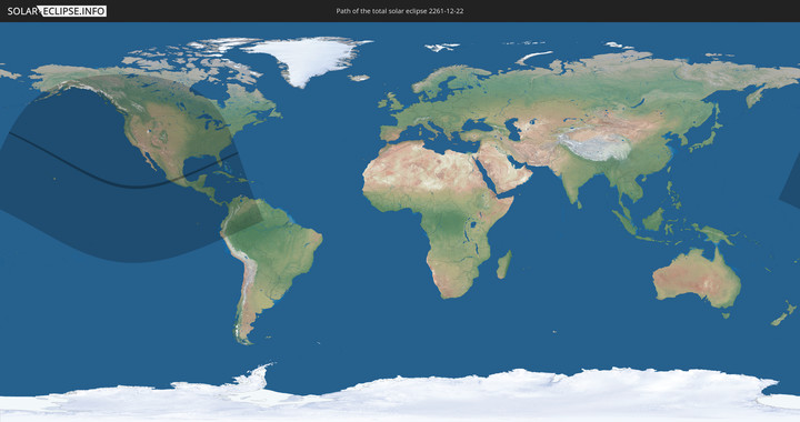
Total solar eclipse of 12/22/2261
| Day of week: | Sunday |
| Maximum duration of eclipse: | 03m17s |
| Maximum width of eclipse path: | 147 km |
| Saros cycle: | 136 |
| Coverage: | 100% |
| Magnitude: | 1.0337 |
| Gamma: | 0.636 |
Wo kann man die Sonnenfinsternis vom 12/22/2261 sehen?
Die Sonnenfinsternis am 12/22/2261 kann man in 28 Ländern als partielle Sonnenfinsternis beobachten.
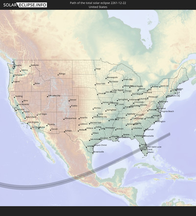
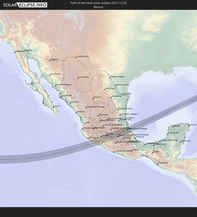
Der Finsternispfad verläuft durch 2 Länder. Nur in diesen Ländern ist sie als total Sonnenfinsternis zu sehen.
In den folgenden Ländern ist die Sonnenfinsternis total zu sehen
In den folgenden Ländern ist die Sonnenfinsternis partiell zu sehen
 United States
 United States Minor Outlying Islands
 Kiribati
 French Polynesia
 Canada
 Mexico
 Greenland
 Guatemala
 Ecuador
 El Salvador
 Honduras
 Belize
 Nicaragua
 Costa Rica
 Cuba
Cuba
 Panama
 Colombia
 Cayman Islands
 Peru
Peru
 The Bahamas
 Jamaica
 Haiti
Haiti
 Brazil
 Venezuela
 Turks and Caicos Islands
 Dominican Republic
 Aruba
Aruba
 Marshall Islands
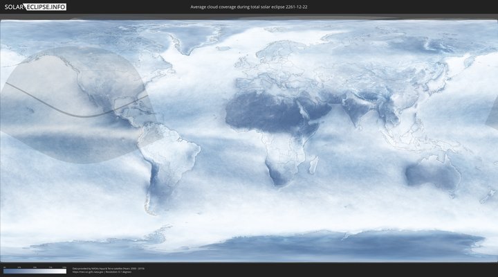
How will be the weather during the total solar eclipse on 12/22/2261?
Where is the best place to see the total solar eclipse of 12/22/2261?
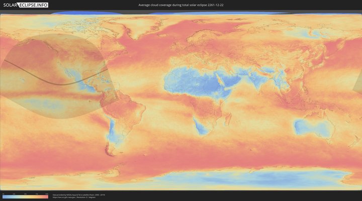
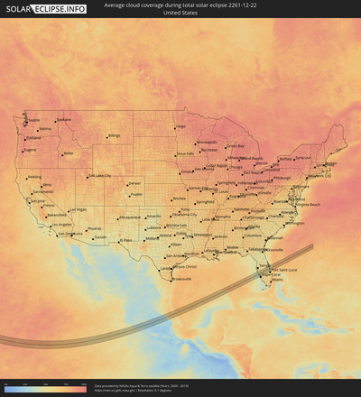
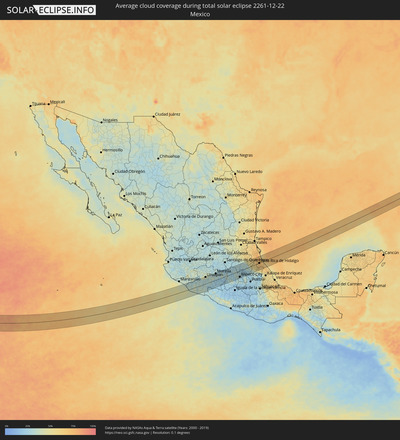
The following maps show the average cloud coverage for the day of the total solar eclipse.
With the help of these maps, it is possible to find the place along the eclipse path, which has the best
chance of a cloudless sky.
Nevertheless, you should consider local circumstances and inform about the weather of your chosen
observation site.
The data is provided by NASAs satellites
AQUA and TERRA.
The cloud maps are averaged over a period of 19 years (2000 - 2019).
Detailed country maps
Cities inside the path of the eclipse
The following table shows all locations with a population of more than 5,000 inside the eclipse path. Cities which have more than 100,000 inhabitants are marked bold. A click at the locations opens a detailed map.
| City | Type | Eclipse duration | Local time of max. eclipse | Distance to central line | Ø Cloud coverage |
 Coahuayana Viejo, Michoacán
|
total | - | 15:22:59 UTC-06:00 | 45 km | 31% |
 Coalcomán de Vázquez Pallares, Michoacán
|
total | - | 15:24:00 UTC-06:00 | 30 km | 31% |
 Aguililla, Michoacán
|
total | - | 15:24:47 UTC-06:00 | 13 km | 33% |
 Felipe Carrillo Puerto, Michoacán
|
total | - | 15:24:43 UTC-06:00 | 55 km | 31% |
 Tancítaro, Michoacán
|
total | - | 15:25:19 UTC-06:00 | 61 km | 30% |
 Apatzingán, Michoacán
|
total | - | 15:25:28 UTC-06:00 | 35 km | 31% |
 Arteaga, Michoacán
|
total | - | 15:25:57 UTC-06:00 | 44 km | 35% |
 La Mira Tumbiscatio, Michoacán
|
total | - | 15:25:49 UTC-06:00 | 10 km | 31% |
 Nueva Italia de Ruiz, Michoacán
|
total | - | 15:26:01 UTC-06:00 | 19 km | 32% |
 Uruapan, Michoacán
|
total | - | 15:25:53 UTC-06:00 | 58 km | 35% |
 Lombardía, Michoacán
|
total | - | 15:26:02 UTC-06:00 | 31 km | 29% |
 Taretán, Michoacán
|
total | - | 15:26:12 UTC-06:00 | 45 km | 29% |
 Tingambato, Michoacán
|
total | - | 15:26:14 UTC-06:00 | 60 km | 37% |
 La Huacana, Michoacán
|
total | - | 15:26:36 UTC-06:00 | 2 km | 31% |
 Ario de Rosales, Michoacán
|
total | - | 15:26:40 UTC-06:00 | 24 km | 35% |
 Pátzcuaro, Michoacán
|
total | - | 15:26:42 UTC-06:00 | 53 km | 34% |
 Puruarán, Michoacán
|
total | - | 15:27:05 UTC-06:00 | 6 km | 27% |
 Pedernales, Michoacán
|
total | - | 15:27:10 UTC-06:00 | 9 km | 27% |
 Tacámbaro de Codallos, Michoacán
|
total | - | 15:27:08 UTC-06:00 | 18 km | 28% |
 Morelia, Michoacán
|
total | - | 15:27:25 UTC-06:00 | 57 km | 29% |
 Indaparapeo, Michoacán
|
total | - | 15:27:47 UTC-06:00 | 58 km | 25% |
 Zinapécuaro, Michoacán
|
total | - | 15:28:00 UTC-06:00 | 60 km | 23% |
 Ciudad Hidalgo, Michoacán
|
total | - | 15:28:36 UTC-06:00 | 33 km | 31% |
 Tuxpan, Michoacán
|
total | - | 15:28:50 UTC-06:00 | 16 km | 27% |
 Maravatío de Ocampo, Michoacán
|
total | - | 15:28:42 UTC-06:00 | 49 km | 24% |
 Luvianos, México
|
total | - | 15:29:17 UTC-06:00 | 54 km | 25% |
 Heróica Zitácuaro, Michoacán
|
total | - | 15:29:06 UTC-06:00 | 2 km | 27% |
 Colorines, México
|
total | - | 15:29:29 UTC-06:00 | 34 km | 29% |
 Valle de Bravo, México
|
total | - | 15:29:38 UTC-06:00 | 35 km | 30% |
 El Oro de Hidalgo, México
|
total | - | 15:29:19 UTC-06:00 | 28 km | 26% |
 Temascalcingo de José María Velazco, México
|
total | - | 15:29:29 UTC-06:00 | 35 km | 25% |
 Jesús del Monte, México
|
total | - | 15:29:56 UTC-06:00 | 48 km | 29% |
 Atlacomulco de Fabela, México
|
total | - | 15:29:47 UTC-06:00 | 18 km | 25% |
 La Concepción de los Baños, México
|
total | - | 15:29:52 UTC-06:00 | 5 km | 24% |
 Barrio de México, México
|
total | - | 15:30:08 UTC-06:00 | 37 km | 30% |
 San Pedro Los Baños, México
|
total | - | 15:29:58 UTC-06:00 | 2 km | 24% |
 Emiliano Zapata (Santo Domingo), México
|
total | - | 15:30:03 UTC-06:00 | 8 km | 24% |
 Ixtlahuaca de Rayón, México
|
total | - | 15:30:06 UTC-06:00 | 10 km | 24% |
 La Cabecera, México
|
total | - | 15:30:15 UTC-06:00 | 33 km | 26% |
 Fraccionamiento Colinas del Sol, México
|
total | - | 15:30:15 UTC-06:00 | 31 km | 26% |
 Santa Cruz Cuauhtenco, México
|
total | - | 15:30:20 UTC-06:00 | 45 km | 32% |
 Toluca, México
|
total | - | 15:30:27 UTC-06:00 | 43 km | 27% |
 Zaragoza de Guadalupe, Morelos
|
total | - | 15:30:32 UTC-06:00 | 58 km | 29% |
 San Bartolomé Tlaltelulco, Morelos
|
total | - | 15:30:32 UTC-06:00 | 51 km | 25% |
 Santa María Nativitas, México
|
total | - | 15:30:32 UTC-06:00 | 52 km | 25% |
 San Nicolás Tolentino, México
|
total | - | 15:30:34 UTC-06:00 | 39 km | 24% |
 Ex-Rancho San Dimas, México
|
total | - | 15:30:40 UTC-06:00 | 59 km | 25% |
 Atizapán, México
|
total | - | 15:30:39 UTC-06:00 | 51 km | 24% |
 La Constitución Toltepec, México
|
total | - | 15:30:36 UTC-06:00 | 41 km | 23% |
 Jilotepec de Molina Enríquez, México
|
total | - | 15:30:19 UTC-06:00 | 21 km | 30% |
 Xonacatlán, México
|
total | - | 15:30:37 UTC-06:00 | 36 km | 26% |
 Ocoyoacac, México
|
total | - | 15:30:49 UTC-06:00 | 53 km | 23% |
 San Francisco Chimalpa, Morelos
|
total | - | 15:30:55 UTC-06:00 | 39 km | 31% |
 Tula de Allende, Hidalgo
|
total | - | 15:30:36 UTC-06:00 | 24 km | 28% |
 Tepeji de Ocampo, Hidalgo
|
total | - | 15:30:41 UTC-06:00 | 9 km | 30% |
 Cuajimalpa, Mexico City
|
total | - | 15:31:03 UTC-06:00 | 50 km | 31% |
 Tezontepec de Aldama, Hidalgo
|
total | - | 15:30:39 UTC-06:00 | 36 km | 30% |
 Ciudad López Mateos, México
|
total | - | 15:31:00 UTC-06:00 | 28 km | 31% |
 Presas, Hidalgo
|
total | - | 15:30:42 UTC-06:00 | 32 km | 30% |
 San Mateo Xoloc, México
|
total | - | 15:30:57 UTC-06:00 | 15 km | 30% |
 Doxey, Hidalgo
|
total | - | 15:30:45 UTC-06:00 | 24 km | 27% |
 Santa Cruz del Monte, México
|
total | - | 15:30:57 UTC-06:00 | 10 km | 29% |
 Atitalaquia, Hidalgo
|
total | - | 15:30:48 UTC-06:00 | 20 km | 27% |
 Vista Hermosa, México
|
total | - | 15:31:06 UTC-06:00 | 36 km | 29% |
 Huehuetoca, México
|
total | - | 15:30:58 UTC-06:00 | 4 km | 29% |
 Teoloyucan, México
|
total | - | 15:31:03 UTC-06:00 | 14 km | 29% |
 Tetepango, Hidalgo
|
total | - | 15:30:54 UTC-06:00 | 22 km | 27% |
 Tequixquiac, México
|
total | - | 15:31:01 UTC-06:00 | 2 km | 25% |
 Mexico City, Mexico City
|
total | - | 15:31:19 UTC-06:00 | 49 km | 25% |
 Ajacuba, Hidalgo
|
total | - | 15:30:58 UTC-06:00 | 20 km | 26% |
 Tepatepec, Hidalgo
|
total | - | 15:30:56 UTC-06:00 | 34 km | 28% |
 Ecatepec, México
|
total | - | 15:31:19 UTC-06:00 | 32 km | 28% |
 San Francisco Zacacalco, Morelos
|
total | - | 15:31:18 UTC-06:00 | 3 km | 24% |
 Tizayuca, Hidalgo
|
total | - | 15:31:21 UTC-06:00 | 12 km | 25% |
 Santa María Chimalhuacán, México
|
total | - | 15:31:37 UTC-06:00 | 56 km | 24% |
 Actopan, Hidalgo
|
total | - | 15:31:11 UTC-06:00 | 31 km | 31% |
 San Agustín Tlaxiaca, Hidalgo
|
total | - | 15:31:22 UTC-06:00 | 13 km | 26% |
 Chiautla, México
|
total | - | 15:31:40 UTC-06:00 | 46 km | 26% |
 Zapotlán de Juárez, Hidalgo
|
total | - | 15:31:29 UTC-06:00 | 2 km | 23% |
 Teotihuacán de Arista, México
|
total | - | 15:31:38 UTC-06:00 | 32 km | 25% |
 Acayuca, Hidalgo
|
total | - | 15:31:29 UTC-06:00 | 2 km | 23% |
 Pachuca de Soto, Hidalgo
|
total | - | 15:31:37 UTC-06:00 | 7 km | 25% |
 Atotonilco el Grande, Hidalgo
|
total | - | 15:31:39 UTC-06:00 | 22 km | 33% |
 Ciudad Sahagun, Hidalgo
|
total | - | 15:32:05 UTC-06:00 | 34 km | 23% |
 Calpulalpan, Tlaxcala
|
total | - | 15:32:11 UTC-06:00 | 54 km | 28% |
 Tulancingo, Hidalgo
|
total | - | 15:32:17 UTC-06:00 | 11 km | 33% |
 Huauchinango, Puebla
|
total | - | 15:32:45 UTC-06:00 | 14 km | 48% |
 Tenango de las Flores, Puebla
|
total | - | 15:32:50 UTC-06:00 | 13 km | 51% |
 Zacatlán, Puebla
|
total | - | 15:33:02 UTC-06:00 | 42 km | 35% |
 Xicotepec de Juárez, Puebla
|
total | - | 15:32:51 UTC-06:00 | 7 km | 54% |
 La Ceiba, Veracruz
|
total | - | 15:32:40 UTC-06:00 | 40 km | 63% |
 Filomeno Mata, Puebla
|
total | - | 15:33:19 UTC-06:00 | 25 km | 58% |
 Álamo, Veracruz
|
total | - | 15:32:58 UTC-06:00 | 47 km | 70% |
 Venustiano Carranza, Puebla
|
total | - | 15:33:12 UTC-06:00 | 5 km | 64% |
 Tihuatlan, Veracruz
|
total | - | 15:33:19 UTC-06:00 | 22 km | 72% |
 Poza Rica de Hidalgo, Veracruz
|
total | - | 15:33:32 UTC-06:00 | 0 km | 70% |
 Tuxpan de Rodríguez Cano, Veracruz
|
total | - | 15:33:23 UTC-06:00 | 42 km | 69% |
 Papantla de Olarte, Veracruz
|
total | - | 15:33:48 UTC-06:00 | 14 km | 68% |
 Gutiérrez Zamora, Veracruz
|
total | - | 15:34:11 UTC-06:00 | 23 km | 66% |
 Vega de San Marcos, Veracruz
|
total | - | 15:34:33 UTC-06:00 | 56 km | 67% |
 Siesta Key, Florida
|
total | - | 16:46:39 UTC-05:00 | 34 km | 52% |
 Sarasota, Florida
|
total | - | 16:46:36 UTC-05:00 | 40 km | 52% |
 North Sarasota, Florida
|
total | - | 16:46:35 UTC-05:00 | 43 km | 57% |
 Gulf Gate Estates, Florida
|
total | - | 16:46:41 UTC-05:00 | 31 km | 52% |
 Southgate, Florida
|
total | - | 16:46:38 UTC-05:00 | 36 km | 52% |
 South Gate Ridge, Florida
|
total | - | 16:46:40 UTC-05:00 | 33 km | 52% |
 Osprey, Florida
|
total | - | 16:46:45 UTC-05:00 | 24 km | 47% |
 Bee Ridge, Florida
|
total | - | 16:46:41 UTC-05:00 | 32 km | 52% |
 Sarasota Springs, Florida
|
total | - | 16:46:40 UTC-05:00 | 35 km | 52% |
 Laurel, Florida
|
total | - | 16:46:48 UTC-05:00 | 18 km | 44% |
 Fruitville, Florida
|
total | - | 16:46:40 UTC-05:00 | 36 km | 52% |
 Venice, Florida
|
total | - | 16:46:51 UTC-05:00 | 13 km | 44% |
 South Venice, Florida
|
total | - | 16:46:55 UTC-05:00 | 7 km | 49% |
 Venice Gardens, Florida
|
total | - | 16:46:54 UTC-05:00 | 8 km | 49% |
 Englewood, Florida
|
total | - | 16:47:02 UTC-05:00 | 5 km | 45% |
 Rotonda, Florida
|
total | - | 16:47:09 UTC-05:00 | 16 km | 47% |
 Warm Mineral Springs, Florida
|
total | - | 16:47:02 UTC-05:00 | 0 km | 51% |
 North Port, Florida
|
total | - | 16:47:04 UTC-05:00 | 2 km | 48% |
 Port Charlotte, Florida
|
total | - | 16:47:14 UTC-05:00 | 16 km | 54% |
 Punta Gorda Isles, Florida
|
total | - | 16:47:17 UTC-05:00 | 22 km | 49% |
 Punta Gorda, Florida
|
total | - | 16:47:18 UTC-05:00 | 22 km | 53% |
 Arcadia, Florida
|
total | - | 16:47:13 UTC-05:00 | 2 km | 58% |
 Southeast Arcadia, Florida
|
total | - | 16:47:15 UTC-05:00 | 6 km | 58% |
 Wauchula, Florida
|
total | - | 16:46:59 UTC-05:00 | 28 km | 57% |
 Avon Park, Florida
|
total | - | 16:47:11 UTC-05:00 | 20 km | 58% |
 Sebring, Florida
|
total | - | 16:47:19 UTC-05:00 | 7 km | 54% |
 West Melbourne, Florida
|
total | - | 16:47:25 UTC-05:00 | 28 km | 61% |
 South Patrick Shores, Florida
|
total | - | 16:47:20 UTC-05:00 | 39 km | 55% |
 Melbourne, Florida
|
total | - | 16:47:26 UTC-05:00 | 28 km | 60% |
 Fellsmere, Florida
|
total | - | 16:47:42 UTC-05:00 | 4 km | 58% |
 Satellite Beach, Florida
|
total | - | 16:47:22 UTC-05:00 | 36 km | 55% |
 Palm Bay, Florida
|
total | - | 16:47:29 UTC-05:00 | 22 km | 58% |
 Indian Harbour Beach, Florida
|
total | - | 16:47:24 UTC-05:00 | 33 km | 60% |
 Micco, Florida
|
total | - | 16:47:41 UTC-05:00 | 3 km | 57% |
 West Vero Corridor, Florida
|
total | - | 16:47:53 UTC-05:00 | 22 km | 62% |
 Sebastian, Florida
|
total | - | 16:47:45 UTC-05:00 | 5 km | 56% |
 Vero Beach South, Florida
|
total | - | 16:47:57 UTC-05:00 | 28 km | 60% |
 Gifford, Florida
|
total | - | 16:47:55 UTC-05:00 | 22 km | 57% |
 Lakewood Park, Florida
|
total | - | 16:48:01 UTC-05:00 | 35 km | 63% |
 Vero Beach, Florida
|
total | - | 16:47:57 UTC-05:00 | 26 km | 60% |
 Florida Ridge, Florida
|
total | - | 16:48:00 UTC-05:00 | 32 km | 60% |
 Lakewood Park, Florida
|
total | - | 16:48:05 UTC-05:00 | 43 km | 63% |
 Fort Pierce North, Florida
|
total | - | 16:48:06 UTC-05:00 | 44 km | 63% |
