Annular solar eclipse of 11/21/2272
| Day of week: | Thursday |
| Maximum duration of eclipse: | 06m15s |
| Maximum width of eclipse path: | 402 km |
| Saros cycle: | 137 |
| Coverage: | 92.8% |
| Magnitude: | 0.9275 |
| Gamma: | -0.7327 |
Wo kann man die Sonnenfinsternis vom 11/21/2272 sehen?

Die Sonnenfinsternis am 11/21/2272 kann man in 13 Ländern als partielle Sonnenfinsternis beobachten.
Der Finsternispfad verläuft durch 3 Länder. Nur in diesen Ländern ist sie als annular Sonnenfinsternis zu sehen.
In den folgenden Ländern ist die Sonnenfinsternis annular zu sehen
 Antarctica
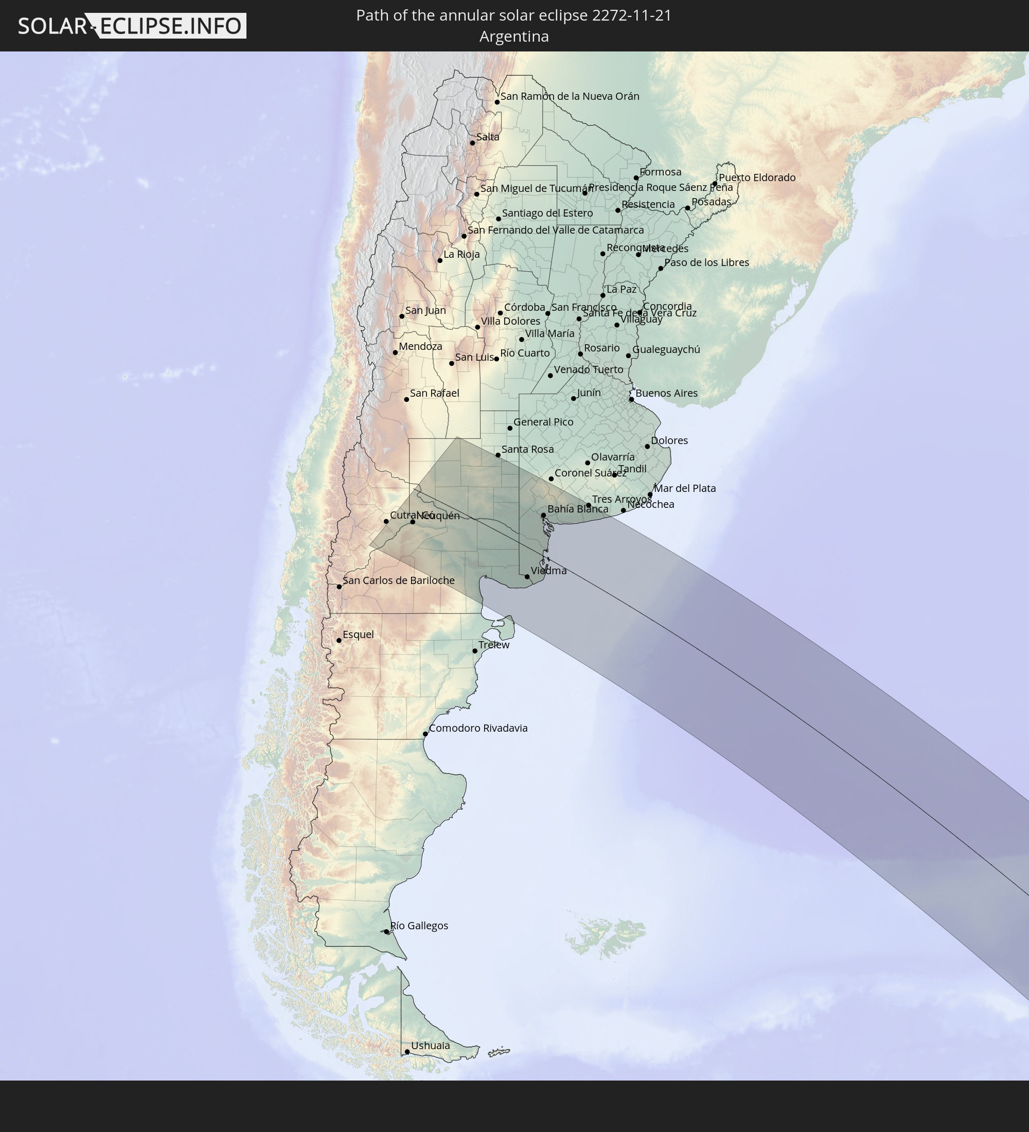 Argentina
 South Georgia and the South Sandwich Islands
In den folgenden Ländern ist die Sonnenfinsternis partiell zu sehen


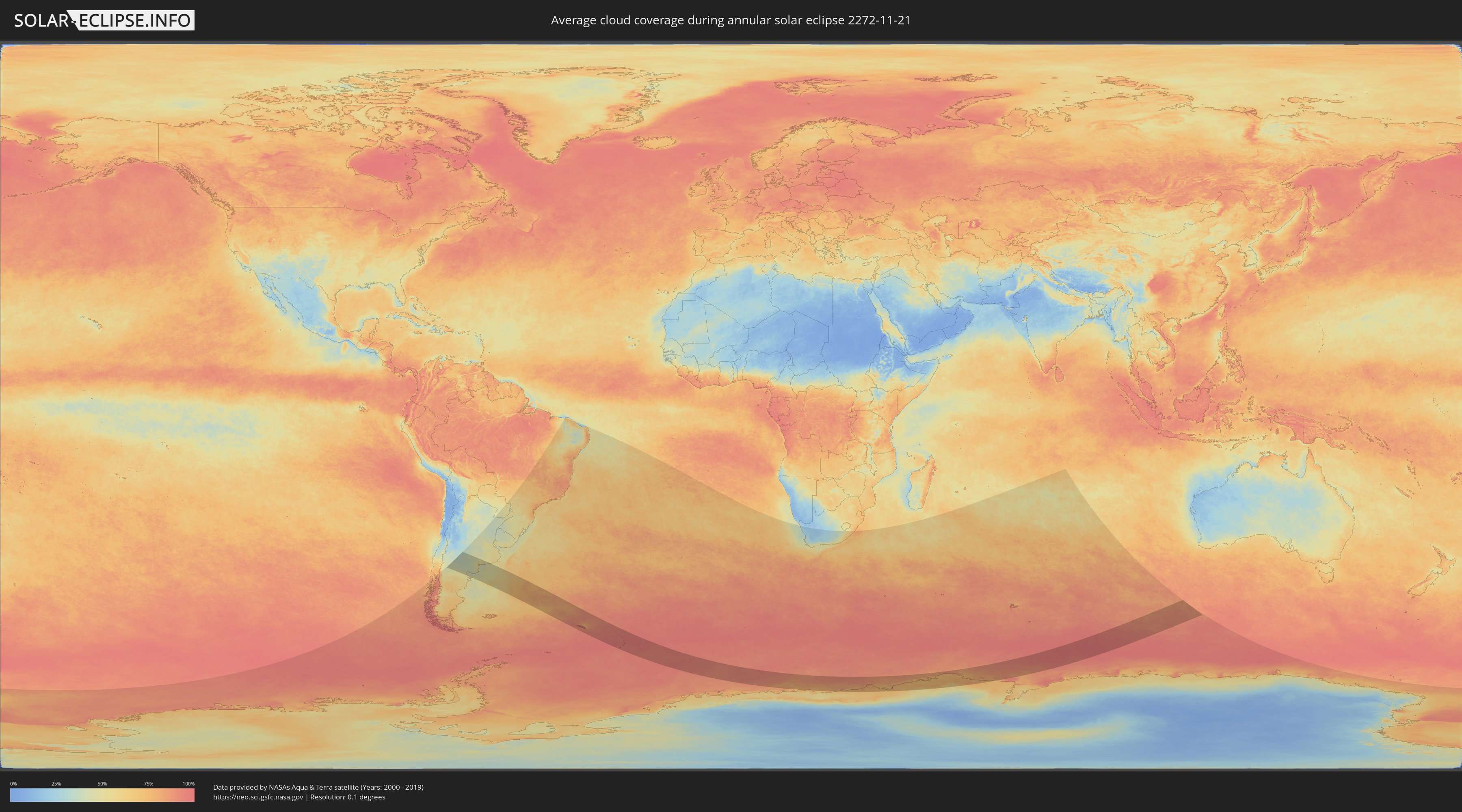
How will be the weather during the annular solar eclipse on 11/21/2272?
Where is the best place to see the annular solar eclipse of 11/21/2272?
The following maps show the average cloud coverage for the day of the annular solar eclipse.
With the help of these maps, it is possible to find the place along the eclipse path, which has the best
chance of a cloudless sky.
Nevertheless, you should consider local circumstances and inform about the weather of your chosen
observation site.
The data is provided by NASAs satellites
AQUA and TERRA.
The cloud maps are averaged over a period of 19 years (2000 - 2019).

Detailed country maps
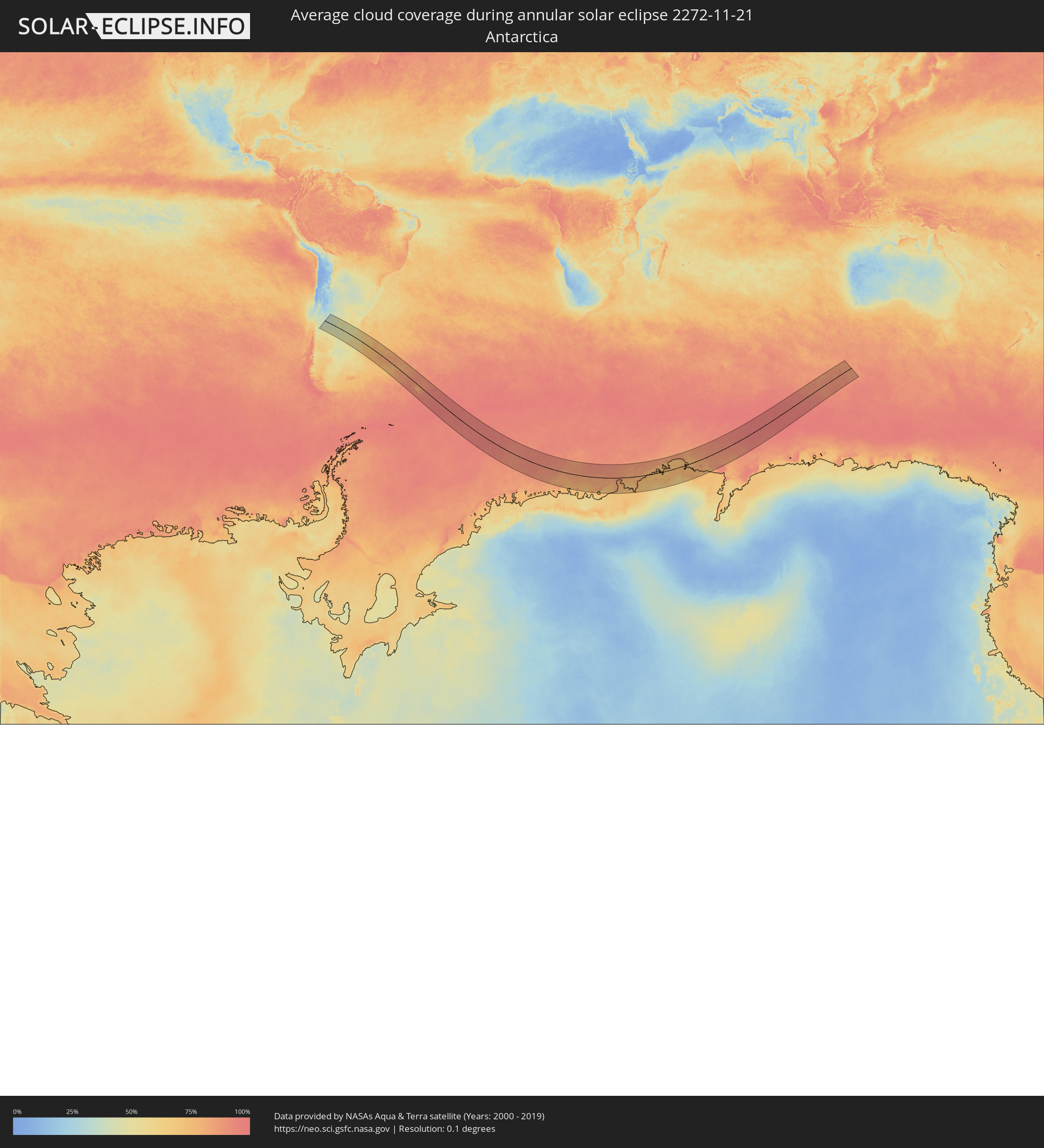 Antarctica
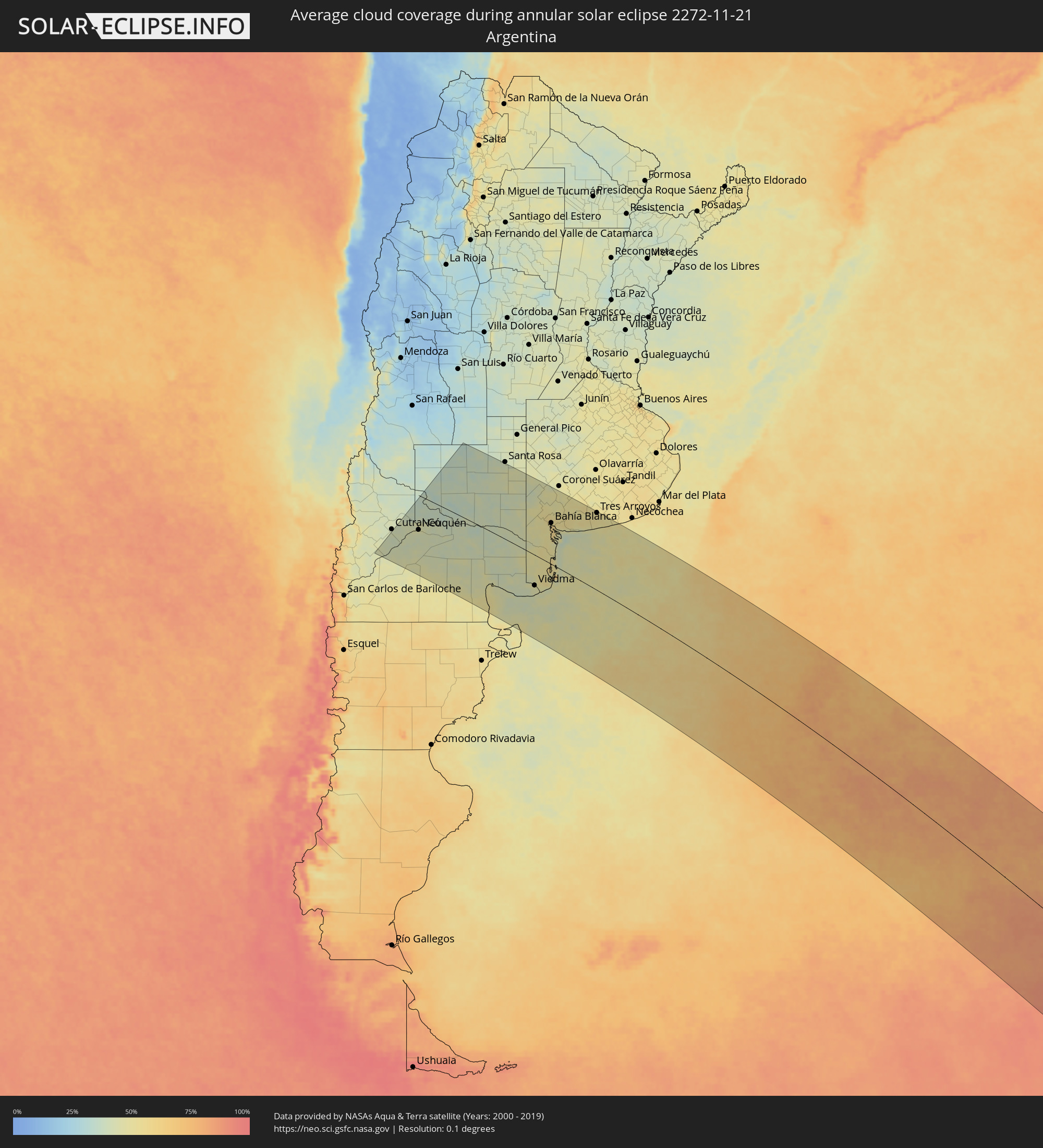 Argentina
 South Georgia and the South Sandwich Islands
Cities inside the path of the eclipse
The following table shows all locations with a population of more than 5,000 inside the eclipse path. Cities which have more than 100,000 inhabitants are marked bold. A click at the locations opens a detailed map.
| City | Type | Eclipse duration | Local time of max. eclipse | Distance to central line | Ø Cloud coverage |
 Senillosa, Neuquén Province
|
annular | - | 06:14:10 UTC-03:00 | 138 km | 43% |
|
Plottier, Neuquén Province
|
annular | - | 06:14:01 UTC-03:00 | 126 km | 43% |
|
Centenario, Neuquén Province
|
annular | - | 06:13:47 UTC-03:00 | 109 km | 44% |
|
Cinco Saltos, Río Negro Province
|
annular | - | 06:13:44 UTC-03:00 | 105 km | 44% |
|
Neuquén, Neuquén Province
|
annular | - | 06:13:55 UTC-03:00 | 118 km | 42% |
|
Cipolletti, Río Negro Province
|
annular | - | 06:13:51 UTC-03:00 | 113 km | 45% |
|
General Fernández Oro, Río Negro Province
|
annular | - | 06:13:51 UTC-03:00 | 113 km | 42% |
|
Allen, Río Negro Province
|
annular | - | 06:13:50 UTC-03:00 | 111 km | 42% |
|
Catriel, Río Negro Province
|
annular | - | 06:12:22 UTC-03:00 | 20 km | 38% |
|
Veinticinco de Mayo, La Pampa Province
|
annular | - | 06:12:11 UTC-03:00 | 25 km | 39% |
|
General Roca, Río Negro Province
|
annular | - | 06:13:48 UTC-03:00 | 108 km | 44% |
|
Cervantes, Río Negro Province
|
annular | - | 06:13:43 UTC-03:00 | 102 km | 42% |
|
Ingeniero Luis A. Huergo, Río Negro Province
|
annular | - | 06:13:42 UTC-03:00 | 101 km | 41% |
|
Villa Regina, Río Negro Province
|
annular | - | 06:13:38 UTC-03:00 | 94 km | 41% |
|
Fray Luis Beltrán, Río Negro Province
|
annular | - | 06:13:21 UTC-03:00 | 65 km | 44% |
|
Lamarque, Río Negro Province
|
annular | - | 06:13:28 UTC-03:00 | 75 km | 43% |
|
Choele Choel, Río Negro Province
|
annular | - | 06:13:15 UTC-03:00 | 57 km | 44% |
|
Victorica, La Pampa Province
|
annular | - | 06:09:03 UTC-03:00 | 258 km | 40% |
|
San Antonio Oeste, Río Negro Province
|
annular | - | 06:14:59 UTC-03:00 | 171 km | 51% |
|
General Acha, La Pampa Province
|
annular | - | 06:10:12 UTC-03:00 | 174 km | 42% |
|
General Conesa, Río Negro Province
|
annular | - | 06:13:53 UTC-03:00 | 88 km | 43% |
|
Guatraché, La Pampa Province
|
annular | - | 06:10:08 UTC-03:00 | 188 km | 40% |
|
Viedma, Río Negro Province
|
annular | - | 06:14:21 UTC-03:00 | 99 km | 47% |
|
Bahía Blanca, Buenos Aires
|
annular | - | 06:11:05 UTC-03:00 | 135 km | 53% |
|
Punta Alta, Buenos Aires
|
annular | - | 06:11:14 UTC-03:00 | 130 km | 48% |
|
Coronel Dorrego, Buenos Aires
|
annular | - | 06:10:43 UTC-03:00 | 178 km | 51% |
|
Tres Arroyos, Buenos Aires
|
annular | - | 06:09:52 UTC-03:00 | 252 km | 52% |
 Grytviken
|
annular | - | 07:38:13 UTC-02:00 | 122 km | 92% |