Total solar eclipse of 08/02/2418
| Day of week: | Thursday |
| Maximum duration of eclipse: | 03m50s |
| Maximum width of eclipse path: | 137 km |
| Saros cycle: | 152 |
| Coverage: | 100% |
| Magnitude: | 1.0406 |
| Gamma: | -0.1242 |
Wo kann man die Sonnenfinsternis vom 08/02/2418 sehen?

Die Sonnenfinsternis am 08/02/2418 kann man in 52 Ländern als partielle Sonnenfinsternis beobachten.
Der Finsternispfad verläuft durch 6 Länder. Nur in diesen Ländern ist sie als total Sonnenfinsternis zu sehen.
In den folgenden Ländern ist die Sonnenfinsternis total zu sehen
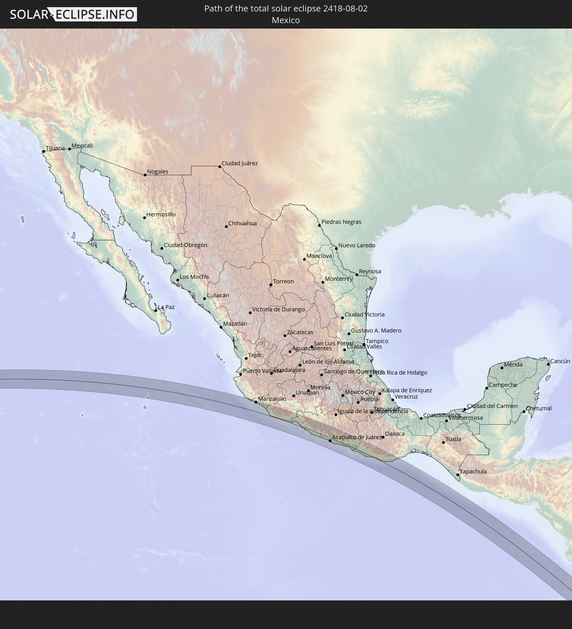 Mexico
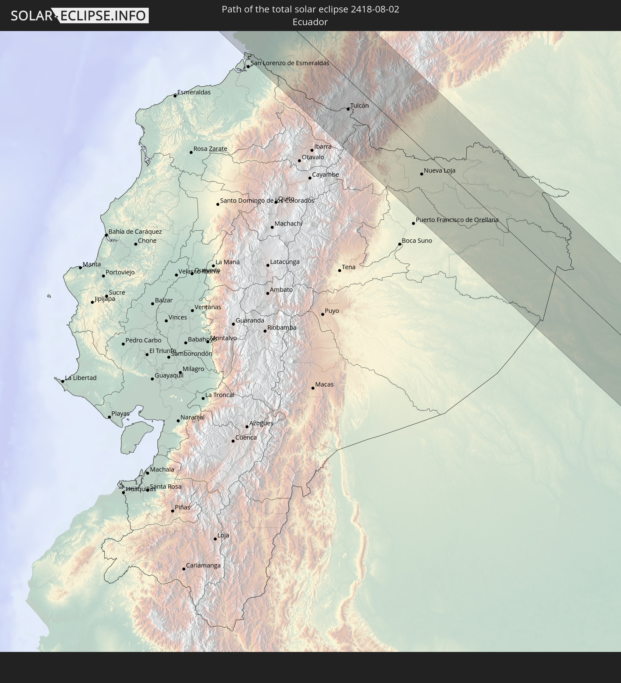 Ecuador
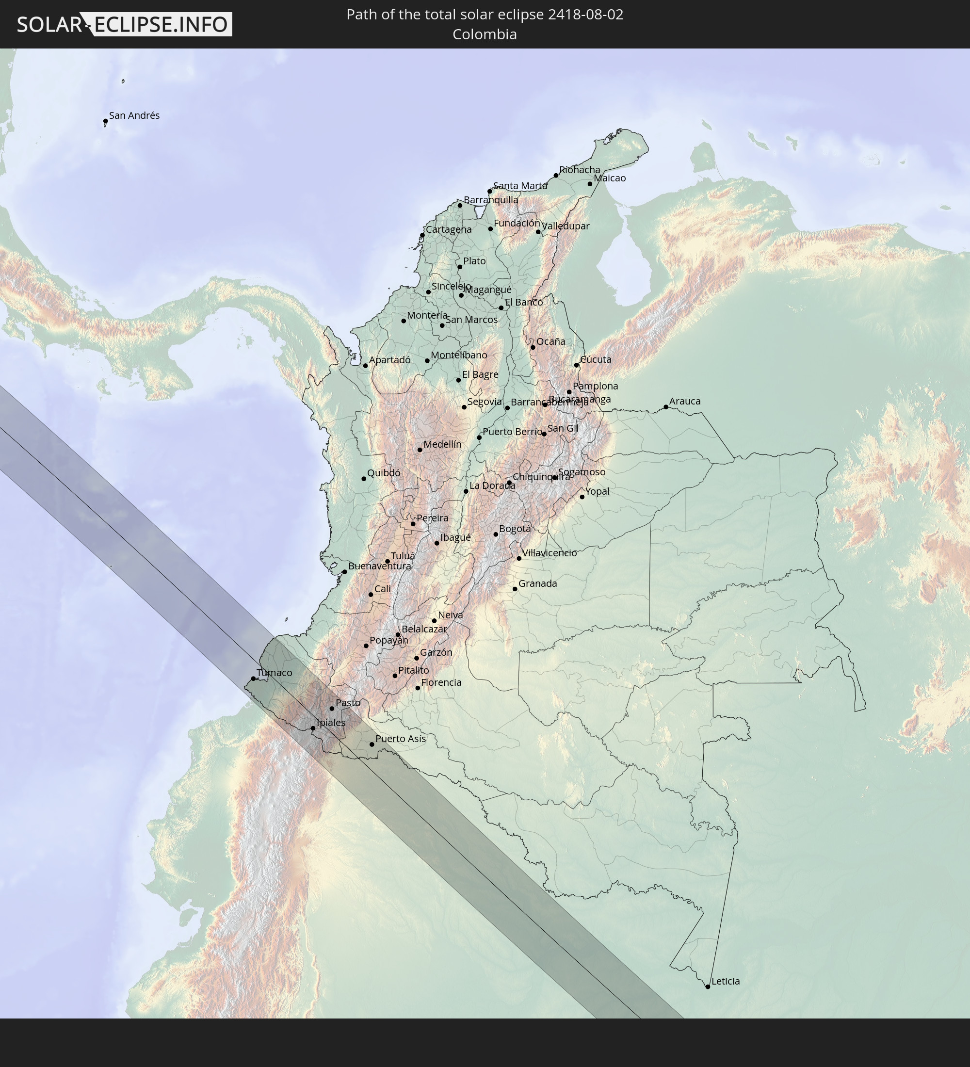 Colombia
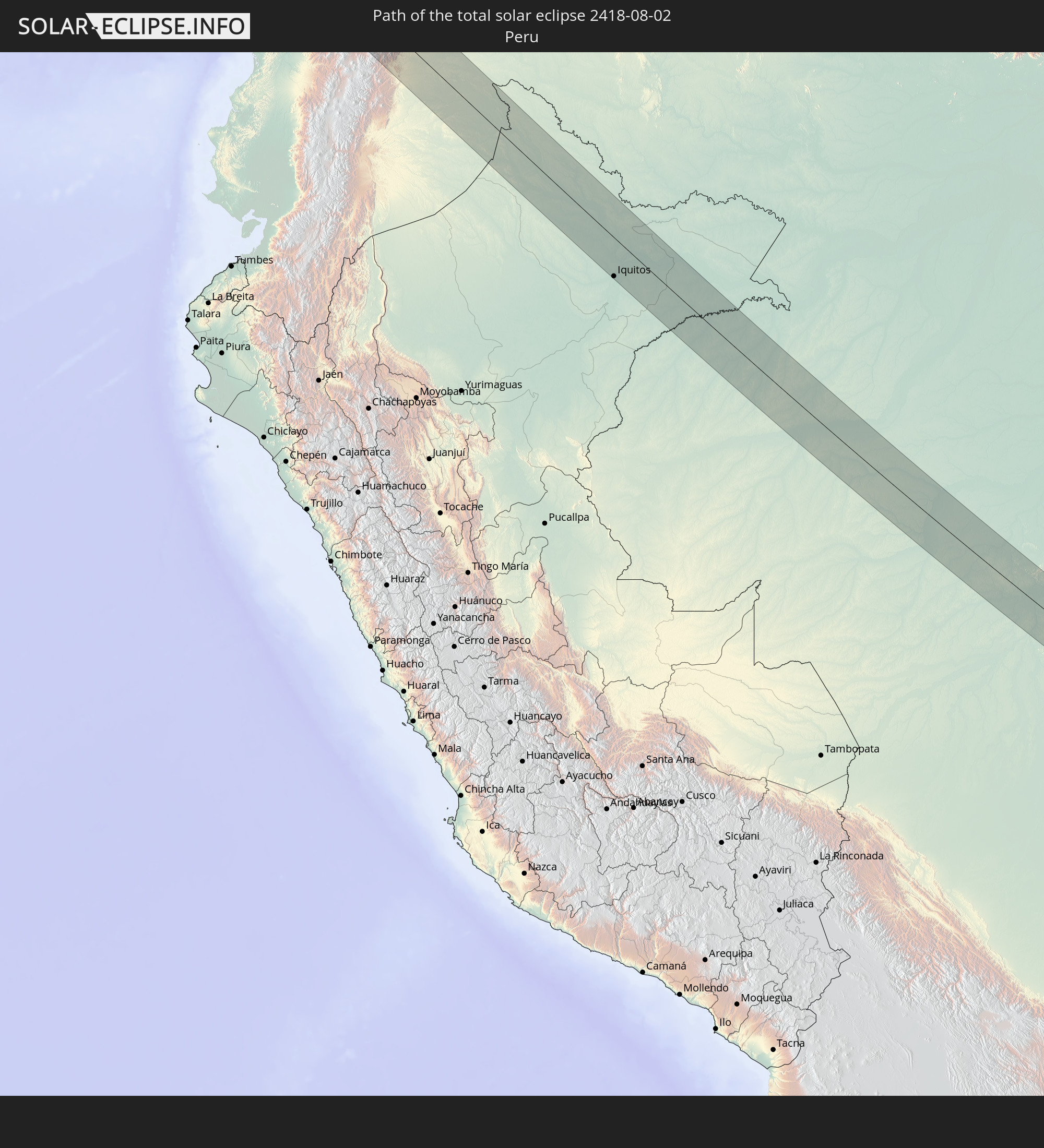 Peru
Peru
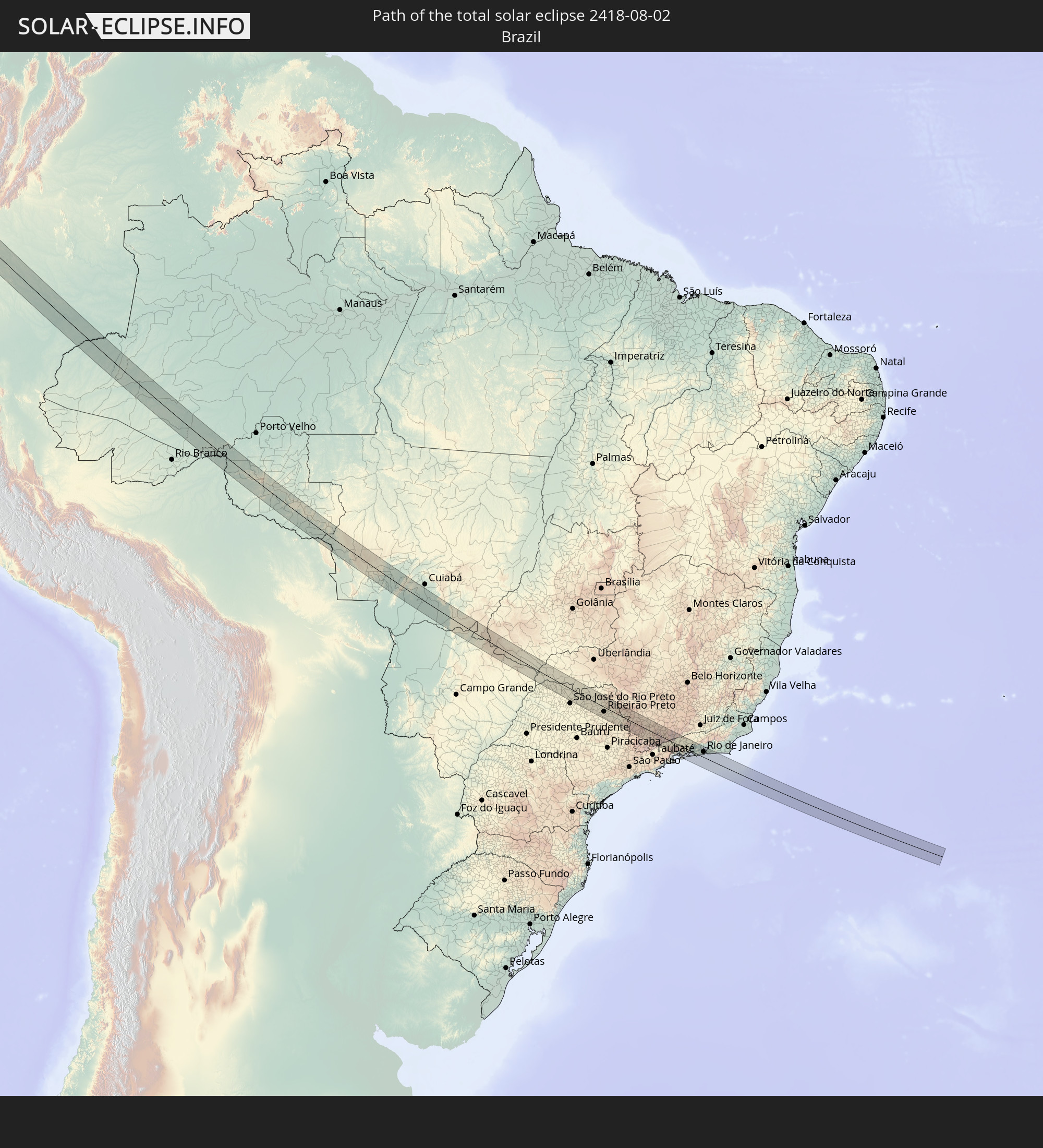 Brazil
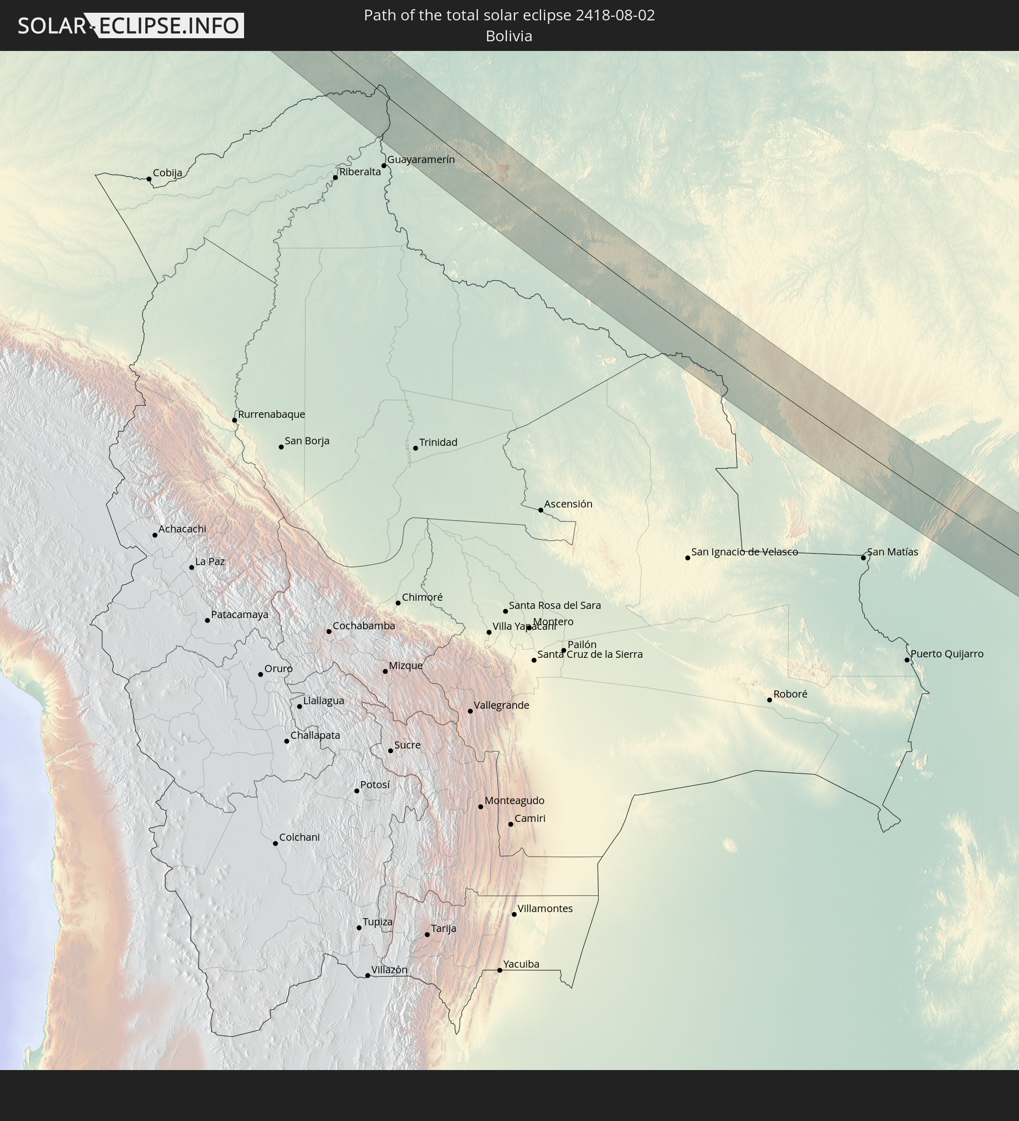 Bolivia
In den folgenden Ländern ist die Sonnenfinsternis partiell zu sehen
 United States
 United States Minor Outlying Islands
 French Polynesia
 Canada
 Mexico
 Chile
Chile
 Guatemala
 Ecuador
 El Salvador
 Honduras
 Belize
 Nicaragua
 Costa Rica
 Cuba
Cuba
 Panama
 Colombia
 Cayman Islands
 Peru
Peru
 The Bahamas
 Jamaica
 Haiti
Haiti
 Brazil
 Argentina
 Venezuela
 Turks and Caicos Islands
 Dominican Republic
 Aruba
Aruba
 Bolivia
 Puerto Rico
 United States Virgin Islands
 Bermuda
 British Virgin Islands
 Anguilla
 Collectivity of Saint Martin
 Saint Barthélemy
 Saint Kitts and Nevis
 Paraguay
 Antigua and Barbuda
 Montserrat
 Trinidad and Tobago
 Guadeloupe
 Grenada
 Dominica
 Saint Vincent and the Grenadines
 Falkland Islands
 Guyana
 Martinique
 Saint Lucia
 Barbados
 Uruguay
 Suriname
 French Guiana
How will be the weather during the total solar eclipse on 08/02/2418?
Where is the best place to see the total solar eclipse of 08/02/2418?
The following maps show the average cloud coverage for the day of the total solar eclipse.
With the help of these maps, it is possible to find the place along the eclipse path, which has the best
chance of a cloudless sky.
Nevertheless, you should consider local circumstances and inform about the weather of your chosen
observation site.
The data is provided by NASAs satellites
AQUA and TERRA.
The cloud maps are averaged over a period of 19 years (2000 - 2019).


Detailed country maps
 Mexico
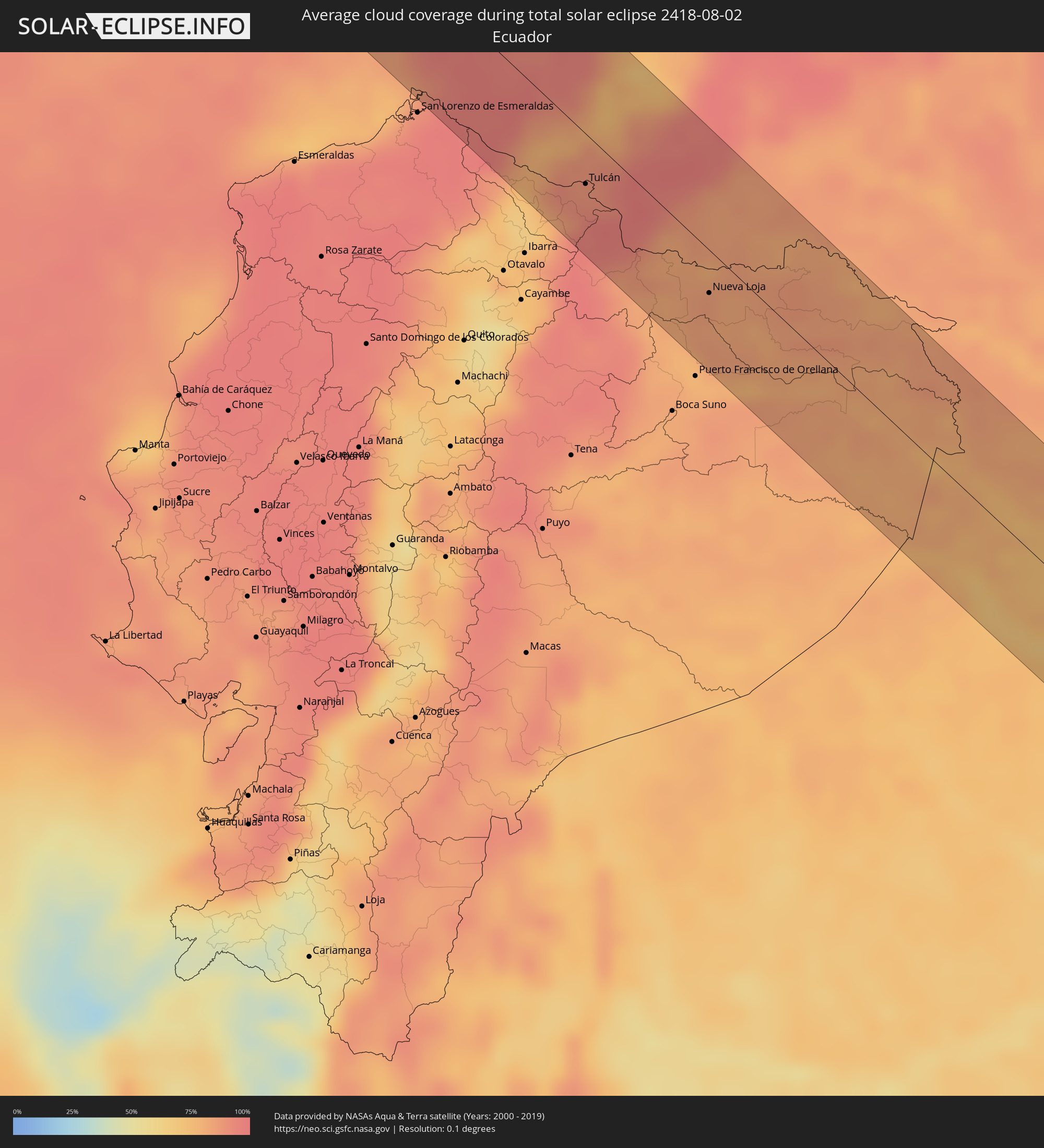 Ecuador
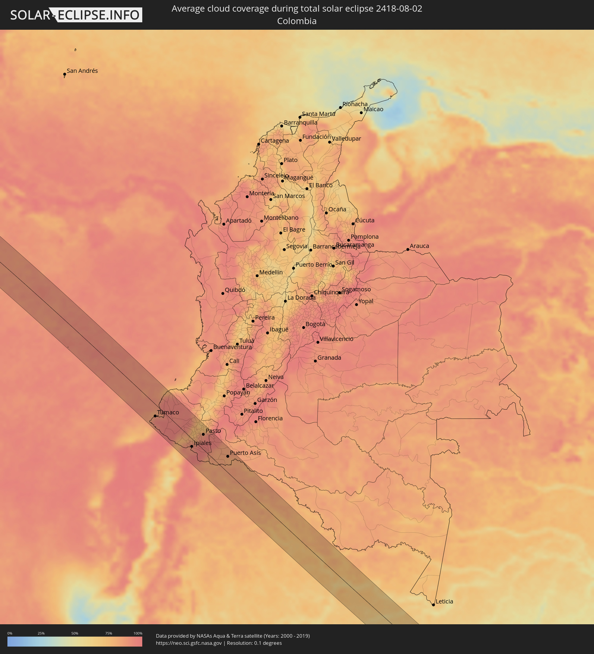 Colombia
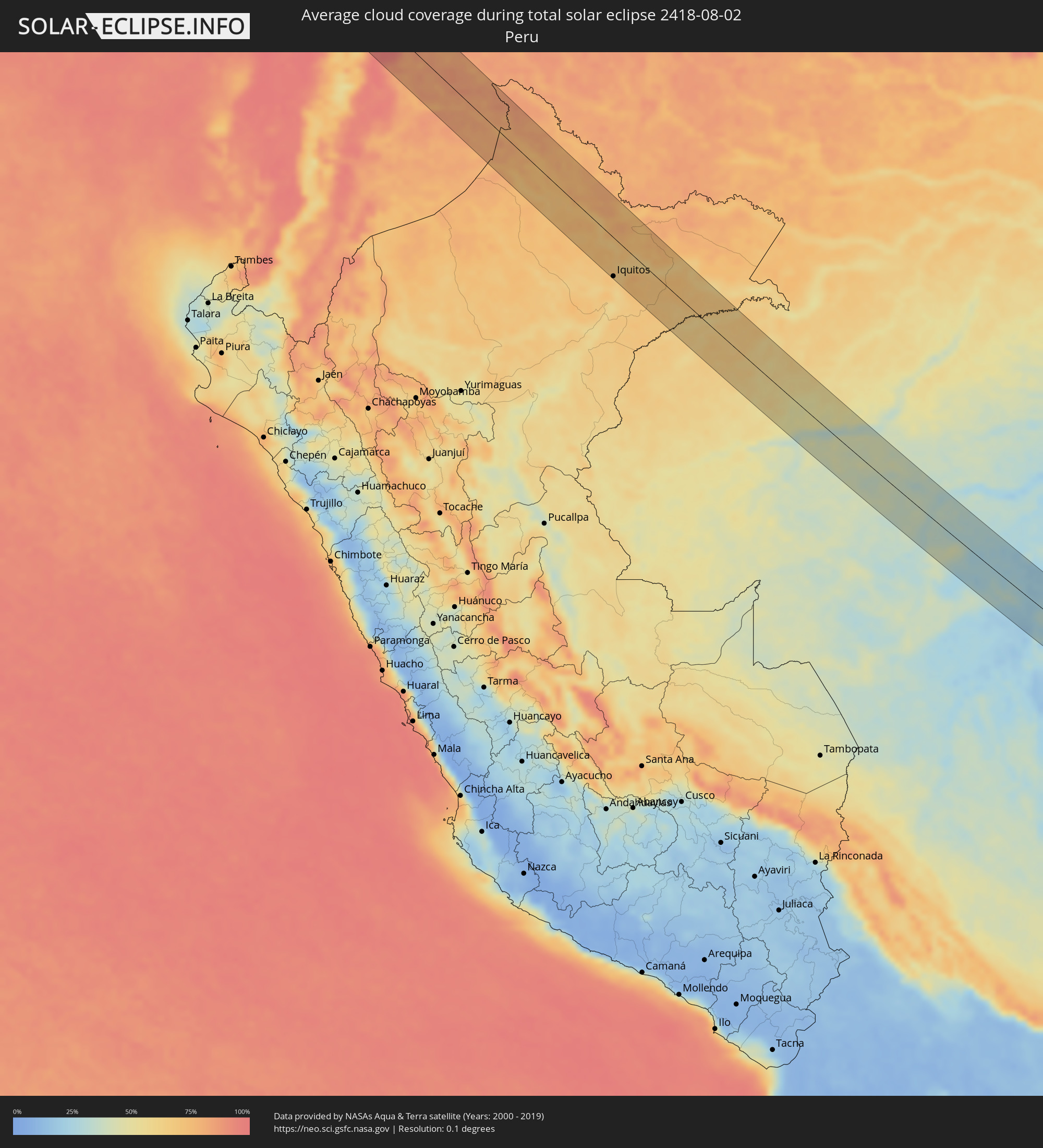 Peru
Peru
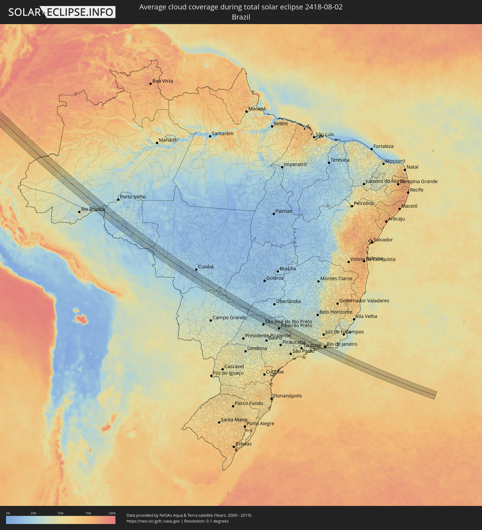 Brazil
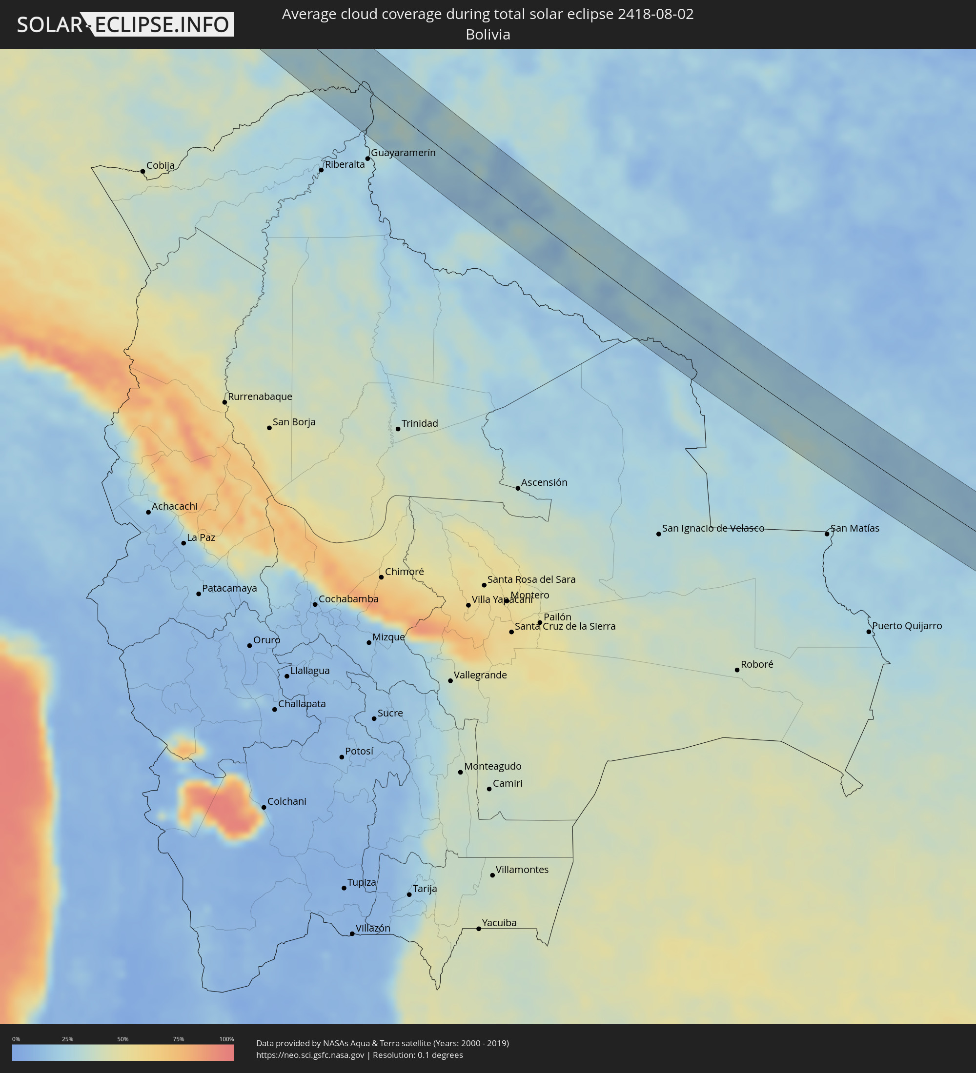 Bolivia
Cities inside the path of the eclipse
The following table shows all locations with a population of more than 5,000 inside the eclipse path. Cities which have more than 100,000 inhabitants are marked bold. A click at the locations opens a detailed map.
| City | Type | Eclipse duration | Local time of max. eclipse | Distance to central line | Ø Cloud coverage |
|
San Patricio, Jalisco
|
total | - | 11:00:52 UTC-06:00 | 63 km | 59% |
|
Manzanillo, Colima
|
total | - | 11:01:55 UTC-06:00 | 56 km | 69% |
|
El Colomo, Colima
|
total | - | 11:02:03 UTC-06:00 | 59 km | 69% |
|
Armeria, Colima
|
total | - | 11:02:51 UTC-06:00 | 54 km | 59% |
|
Tecoman, Colima
|
total | - | 11:03:04 UTC-06:00 | 55 km | 65% |
|
Coahuayana Viejo, Michoacán
|
total | - | 11:03:44 UTC-06:00 | 44 km | 60% |
|
Coalcomán de Vázquez Pallares, Michoacán
|
total | - | 11:04:54 UTC-06:00 | 62 km | 69% |
|
Arteaga, Michoacán
|
total | - | 11:07:25 UTC-06:00 | 47 km | 69% |
|
Buenos Aires, Michoacán
|
total | - | 11:07:47 UTC-06:00 | 12 km | 59% |
|
Ciudad Lázaro Cárdenas, Michoacán
|
total | - | 11:08:00 UTC-06:00 | 9 km | 60% |
|
San José Ixtapa (Barrio Viejo), Guerrero
|
total | - | 11:09:46 UTC-06:00 | 2 km | 58% |
|
Ixtapa-Zihuatanejo, Guerrero
|
total | - | 11:10:00 UTC-06:00 | 2 km | 60% |
|
San Jeronimito, Guerrero
|
total | - | 11:10:36 UTC-06:00 | 2 km | 67% |
|
Petatlán, Guerrero
|
total | - | 11:10:49 UTC-06:00 | 2 km | 60% |
|
El Súchil, Guerrero
|
total | - | 11:12:45 UTC-06:00 | 11 km | 59% |
|
Técpan de Galeana, Guerrero
|
total | - | 11:12:47 UTC-06:00 | 11 km | 59% |
|
San Jerónimo de Juárez, Guerrero
|
total | - | 11:13:16 UTC-06:00 | 13 km | 59% |
|
Atoyac de Álvarez, Guerrero
|
total | - | 11:13:17 UTC-06:00 | 5 km | 58% |
|
Coyuca de Benítez, Guerrero
|
total | - | 11:14:23 UTC-06:00 | 11 km | 55% |
|
Acapulco de Juárez, Guerrero
|
total | - | 11:15:04 UTC-06:00 | 18 km | 60% |
|
Kilómetro 30, Guerrero
|
total | - | 11:15:10 UTC-06:00 | 0 km | 55% |
|
Xaltianguis, Guerrero
|
total | - | 11:15:12 UTC-06:00 | 13 km | 58% |
|
Tierra Colorada, Guerrero
|
total | - | 11:15:35 UTC-06:00 | 27 km | 51% |
|
El Ocotito, Guerrero
|
total | - | 11:15:31 UTC-06:00 | 36 km | 51% |
|
Petaquillas, Guerrero
|
total | - | 11:15:21 UTC-06:00 | 63 km | 65% |
|
San Marcos, Guerrero
|
total | - | 11:16:24 UTC-06:00 | 4 km | 50% |
|
Cruz Grande, Guerrero
|
total | - | 11:17:10 UTC-06:00 | 1 km | 48% |
|
Ayutla de los Libres, Guerrero
|
total | - | 11:16:56 UTC-06:00 | 25 km | 55% |
|
Copala, Guerrero
|
total | - | 11:17:41 UTC-06:00 | 6 km | 51% |
|
Marquelia, Guerrero
|
total | - | 11:18:08 UTC-06:00 | 2 km | 49% |
|
San Luis Acatlán, Guerrero
|
total | - | 11:18:02 UTC-06:00 | 24 km | 55% |
|
Cuajinicuilapa de Santa Maria, Guerrero
|
total | - | 11:19:18 UTC-06:00 | 5 km | 59% |
|
Ometepec, Guerrero
|
total | - | 11:19:01 UTC-06:00 | 27 km | 48% |
|
Pinotepa, Oaxaca
|
total | - | 11:20:23 UTC-06:00 | 7 km | 52% |
|
Jamiltepec, Oaxaca
|
total | - | 11:21:03 UTC-06:00 | 12 km | 56% |
|
Puerto Escondido, Oaxaca
|
total | - | 11:23:32 UTC-06:00 | 5 km | 60% |
|
Brisas de Zicatela, Oaxaca
|
total | - | 11:23:40 UTC-06:00 | 4 km | 60% |
|
San Pedro Pochutla, Oaxaca
|
total | - | 11:25:16 UTC-06:00 | 23 km | 59% |
|
Crucecita, Oaxaca
|
total | - | 11:26:04 UTC-06:00 | 41 km | 60% |
|
Santa María Xadani, Oaxaca
|
total | - | 11:25:58 UTC-06:00 | 62 km | 62% |
|
Tumaco, Nariño
|
total | - | 13:32:37 UTC-05:00 | 31 km | 91% |
|
Francisco Pizarro, Nariño
|
total | - | 13:32:15 UTC-05:00 | 1 km | 88% |
|
Barbacoas, Nariño
|
total | - | 13:34:10 UTC-05:00 | 10 km | 93% |
|
San Gabriel, Carchi
|
total | - | 13:36:42 UTC-05:00 | 53 km | 89% |
|
Cumbal, Nariño
|
total | - | 13:36:13 UTC-05:00 | 25 km | 88% |
|
Tulcán, Carchi
|
total | - | 13:36:32 UTC-05:00 | 27 km | 89% |
|
Ipiales, Nariño
|
total | - | 13:36:38 UTC-05:00 | 20 km | 91% |
|
Pupiales, Nariño
|
total | - | 13:36:34 UTC-05:00 | 16 km | 91% |
|
Túquerres, Nariño
|
total | - | 13:36:13 UTC-05:00 | 3 km | 82% |
|
Samaniego, Nariño
|
total | - | 13:35:49 UTC-05:00 | 25 km | 73% |
|
Guaitarilla, Nariño
|
total | - | 13:36:17 UTC-05:00 | 12 km | 82% |
|
Ancuya, Nariño
|
total | - | 13:36:07 UTC-05:00 | 25 km | 77% |
|
Olaya Herrera, Nariño
|
total | - | 13:36:11 UTC-05:00 | 26 km | 80% |
|
Sandoná, Nariño
|
total | - | 13:36:09 UTC-05:00 | 30 km | 77% |
|
El Tambo, Nariño
|
total | - | 13:36:03 UTC-05:00 | 47 km | 75% |
|
Pasto, Nariño
|
total | - | 13:36:38 UTC-05:00 | 39 km | 90% |
|
Sibundoy, Putumayo
|
total | - | 13:37:20 UTC-05:00 | 65 km | 95% |
|
Valle del Guamuez, Putumayo
|
total | - | 13:38:40 UTC-05:00 | 5 km | 84% |
|
San Miguel, Putumayo
|
total | - | 13:38:53 UTC-05:00 | 4 km | 80% |
|
Nueva Loja, Sucumbios
|
total | - | 13:39:22 UTC-05:00 | 23 km | 85% |
|
Orito, Putumayo
|
total | - | 13:38:23 UTC-05:00 | 26 km | 84% |
|
Puerto Asís, Putumayo
|
total | - | 13:39:20 UTC-05:00 | 42 km | 81% |
|
Iquitos, Loreto
|
total | - | 13:52:05 UTC-05:00 | 60 km | 69% |
|
Lucas, Mato Grosso
|
total | - | 15:26:35 UTC-04:00 | 11 km | 21% |
|
Paranaíba, Mato Grosso do Sul
|
total | - | 15:31:40 UTC-04:00 | 44 km | 25% |
|
Iturama, Minas Gerais
|
total | - | 16:32:14 UTC-03:00 | 2 km | 25% |
|
Frutal, Minas Gerais
|
total | - | 16:33:00 UTC-03:00 | 37 km | 26% |
|
Olímpia, São Paulo
|
total | - | 16:33:19 UTC-03:00 | 31 km | 31% |
|
Barretos, São Paulo
|
total | - | 16:33:24 UTC-03:00 | 4 km | 28% |
|
Bebedouro, São Paulo
|
total | - | 16:33:37 UTC-03:00 | 30 km | 30% |
|
Guaíra, São Paulo
|
total | - | 16:33:25 UTC-03:00 | 40 km | 28% |
|
Pitangueiras, São Paulo
|
total | - | 16:33:45 UTC-03:00 | 23 km | 30% |
|
Sertãozinho, São Paulo
|
total | - | 16:33:55 UTC-03:00 | 24 km | 30% |
|
Orlândia, São Paulo
|
total | - | 16:33:47 UTC-03:00 | 22 km | 33% |
|
São Joaquim da Barra, São Paulo
|
total | - | 16:33:44 UTC-03:00 | 37 km | 33% |
|
Ribeirão Preto, São Paulo
|
total | - | 16:34:00 UTC-03:00 | 20 km | 33% |
|
Jardinópolis, São Paulo
|
total | - | 16:33:58 UTC-03:00 | 2 km | 33% |
|
Cravinhos, São Paulo
|
total | - | 16:34:06 UTC-03:00 | 32 km | 34% |
|
Serrana, São Paulo
|
total | - | 16:34:06 UTC-03:00 | 12 km | 35% |
|
Batatais, São Paulo
|
total | - | 16:33:59 UTC-03:00 | 20 km | 33% |
|
Mococa, São Paulo
|
total | - | 16:34:27 UTC-03:00 | 9 km | 35% |
|
São Sebastião do Paraíso, Minas Gerais
|
total | - | 16:34:15 UTC-03:00 | 46 km | 35% |
|
Vargem Grande do Sul, São Paulo
|
total | - | 16:34:38 UTC-03:00 | 40 km | 40% |
|
São José do Rio Pardo, São Paulo
|
total | - | 16:34:33 UTC-03:00 | 16 km | 39% |
|
Guaxupé, Minas Gerais
|
total | - | 16:34:31 UTC-03:00 | 21 km | 39% |
|
Poços de Caldas, Minas Gerais
|
total | - | 16:34:45 UTC-03:00 | 20 km | 41% |
|
Alfenas, Minas Gerais
|
total | - | 16:34:51 UTC-03:00 | 45 km | 35% |
|
Pouso Alegre, Minas Gerais
|
total | - | 16:35:08 UTC-03:00 | 34 km | 40% |
|
Machado, Minas Gerais
|
total | - | 16:34:57 UTC-03:00 | 22 km | 41% |
|
Santa Rita do Sapucaí, Minas Gerais
|
total | - | 16:35:14 UTC-03:00 | 25 km | 40% |
|
Itajubá, Minas Gerais
|
total | - | 16:35:22 UTC-03:00 | 31 km | 40% |
|
Lorena, São Paulo
|
total | - | 16:35:35 UTC-03:00 | 46 km | 44% |
|
São Lourenço, Minas Gerais
|
total | - | 16:35:25 UTC-03:00 | 18 km | 41% |
|
Cruzeiro, São Paulo
|
total | - | 16:35:35 UTC-03:00 | 24 km | 43% |
|
Resende, Rio de Janeiro
|
total | - | 16:35:44 UTC-03:00 | 11 km | 44% |
|
Angra dos Reis, Rio de Janeiro
|
total | - | 16:35:56 UTC-03:00 | 37 km | 47% |
|
Volta Redonda, Rio de Janeiro
|
total | - | 16:35:51 UTC-03:00 | 21 km | 46% |
|
Barra do Piraí, Rio de Janeiro
|
total | - | 16:35:56 UTC-03:00 | 39 km | 44% |
|
Itaguaí, Rio de Janeiro
|
total | - | 16:36:03 UTC-03:00 | 2 km | 44% |
|
Japeri, Rio de Janeiro
|
total | - | 16:36:02 UTC-03:00 | 29 km | 45% |
|
Nova Iguaçu, Rio de Janeiro
|
total | - | 16:36:08 UTC-03:00 | 26 km | 48% |
|
Rio de Janeiro, Rio de Janeiro
|
total | - | 16:36:14 UTC-03:00 | 23 km | 44% |
|
Maricá, Rio de Janeiro
|
total | - | 16:36:21 UTC-03:00 | 38 km | 47% |