Annular solar eclipse of 09/15/2509
| Day of week: | Sunday |
| Maximum duration of eclipse: | 03m58s |
| Maximum width of eclipse path: | 171 km |
| Saros cycle: | 162 |
| Coverage: | 96% |
| Magnitude: | 0.9604 |
| Gamma: | -0.5679 |
Wo kann man die Sonnenfinsternis vom 09/15/2509 sehen?
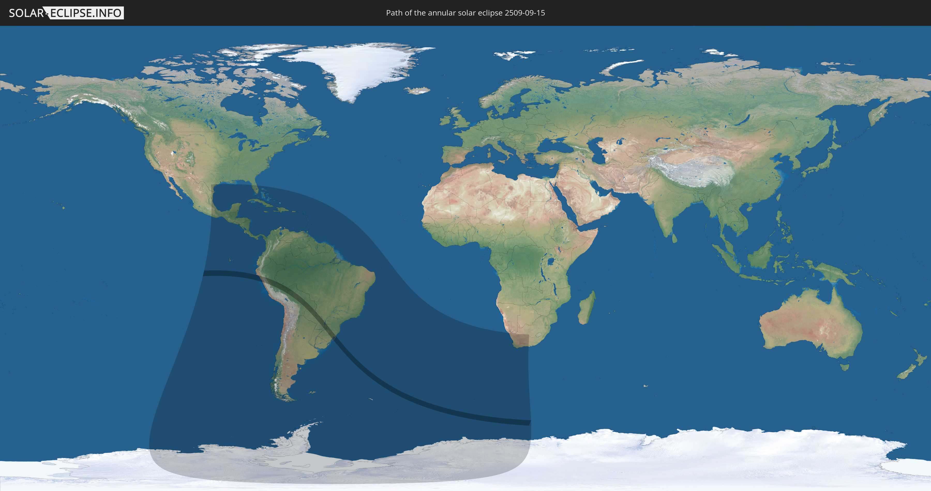
Die Sonnenfinsternis am 09/15/2509 kann man in 54 Ländern als partielle Sonnenfinsternis beobachten.
Der Finsternispfad verläuft durch 5 Länder. Nur in diesen Ländern ist sie als annular Sonnenfinsternis zu sehen.
In den folgenden Ländern ist die Sonnenfinsternis annular zu sehen
 Peru
Peru
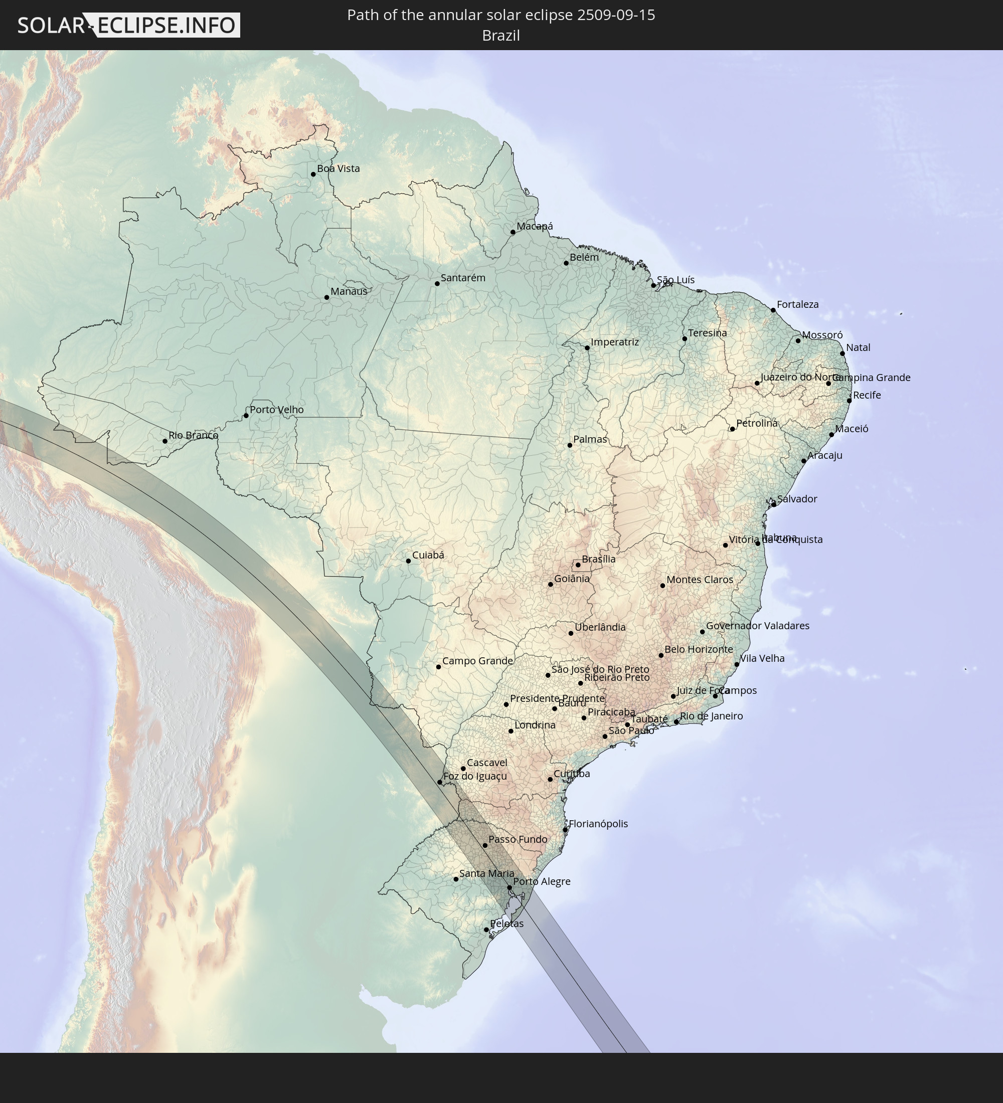 Brazil
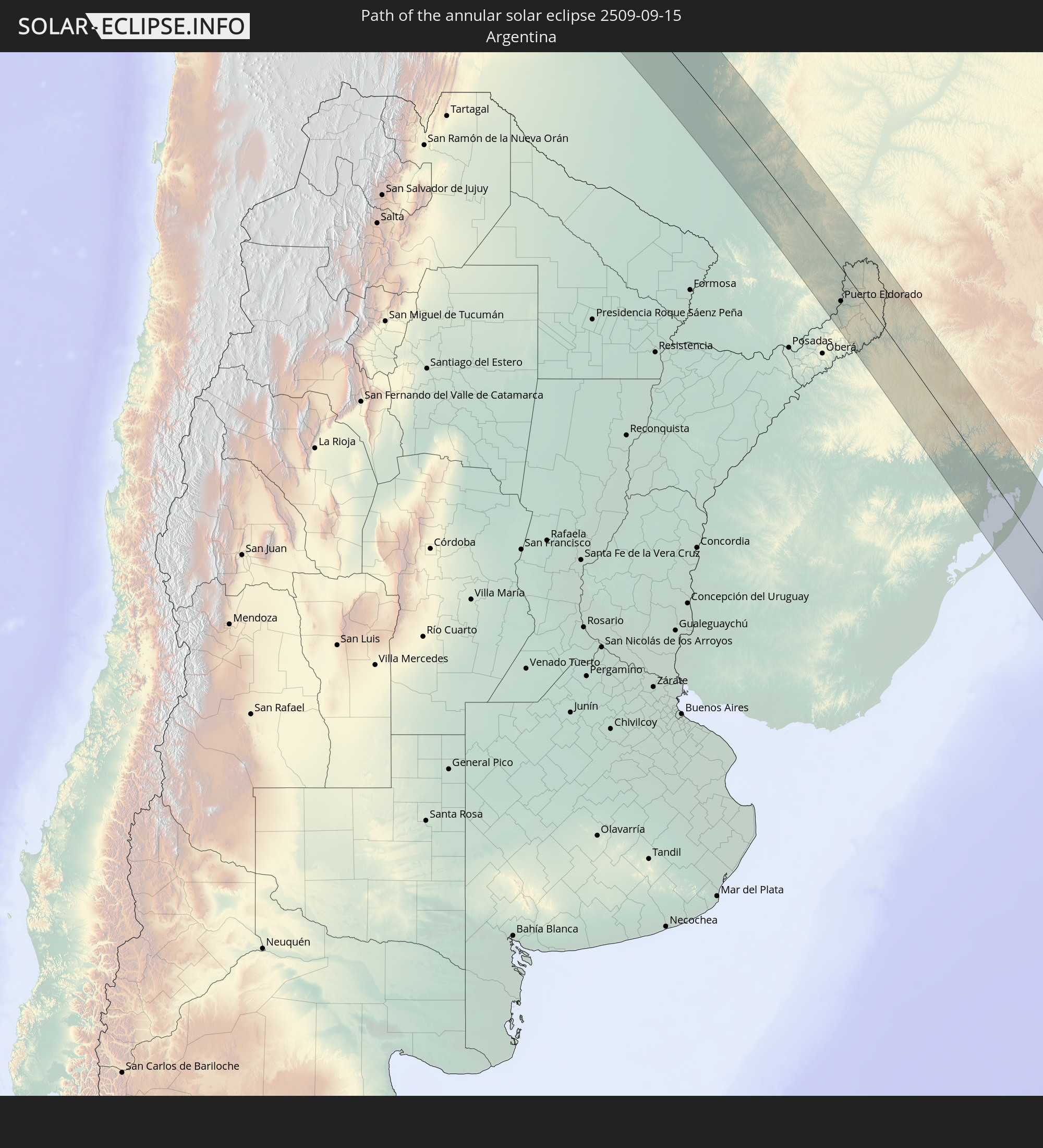 Argentina
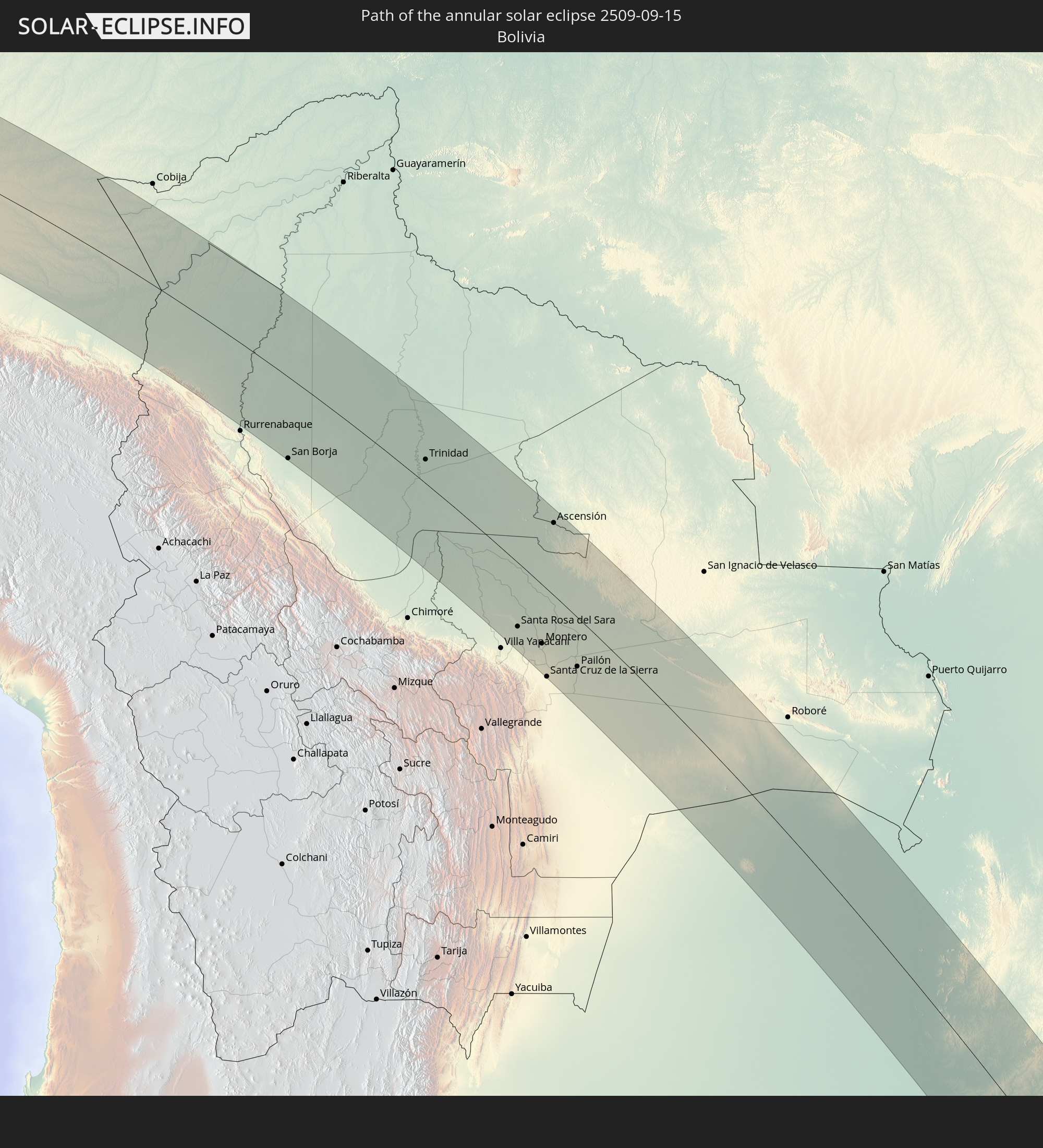 Bolivia
 Paraguay
In den folgenden Ländern ist die Sonnenfinsternis partiell zu sehen
 Antarctica
 United States
 United States Minor Outlying Islands
 Mexico
 Chile
Chile
 Guatemala
 Ecuador
 El Salvador
 Honduras
 Belize
 Nicaragua
 Costa Rica
 Cuba
Cuba
 Panama
 Colombia
 Cayman Islands
 Peru
Peru
 The Bahamas
 Jamaica
 Haiti
Haiti
 Brazil
 Argentina
 Venezuela
 Turks and Caicos Islands
 Dominican Republic
 Aruba
Aruba
 Bolivia
 Puerto Rico
 United States Virgin Islands
 British Virgin Islands
 Anguilla
 Collectivity of Saint Martin
 Saint Barthélemy
 Saint Kitts and Nevis
 Paraguay
 Antigua and Barbuda
 Montserrat
 Trinidad and Tobago
 Guadeloupe
 Grenada
 Dominica
 Saint Vincent and the Grenadines
 Falkland Islands
 Guyana
 Martinique
 Saint Lucia
 Barbados
 Uruguay
 Suriname
 French Guiana
 South Georgia and the South Sandwich Islands
 Saint Helena, Ascension and Tristan da Cunha
 Bouvet Island
 South Africa
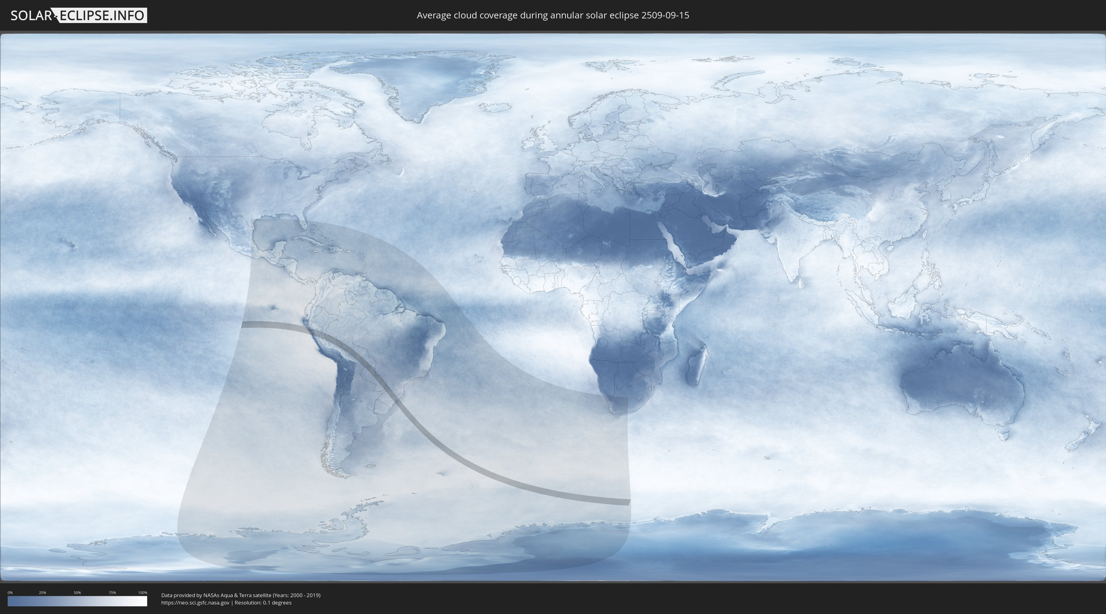
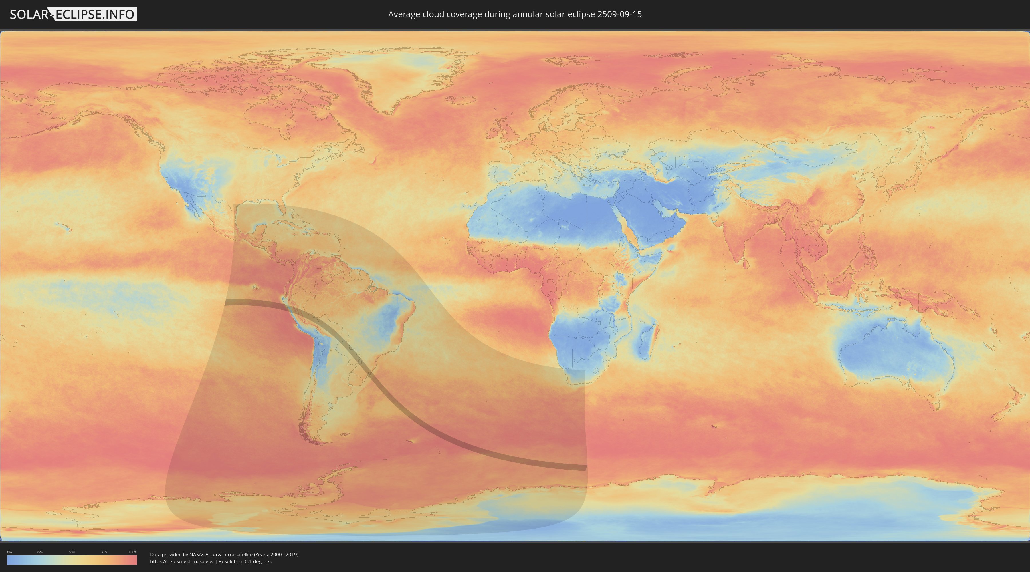
How will be the weather during the annular solar eclipse on 09/15/2509?
Where is the best place to see the annular solar eclipse of 09/15/2509?
The following maps show the average cloud coverage for the day of the annular solar eclipse.
With the help of these maps, it is possible to find the place along the eclipse path, which has the best
chance of a cloudless sky.
Nevertheless, you should consider local circumstances and inform about the weather of your chosen
observation site.
The data is provided by NASAs satellites
AQUA and TERRA.
The cloud maps are averaged over a period of 19 years (2000 - 2019).
Detailed country maps
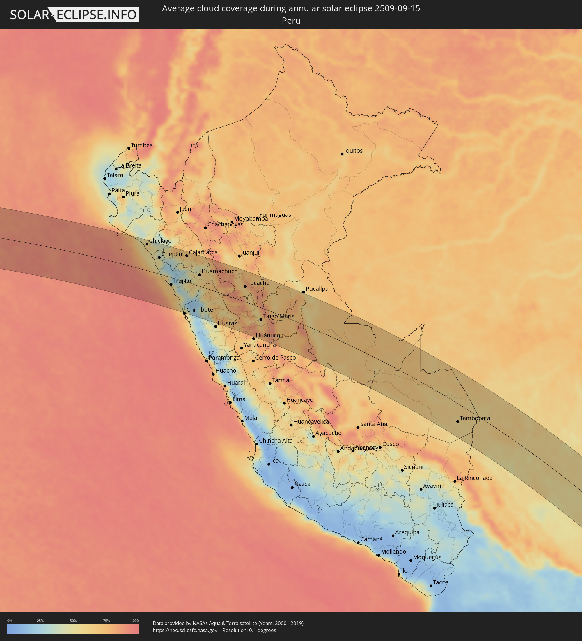 Peru
Peru
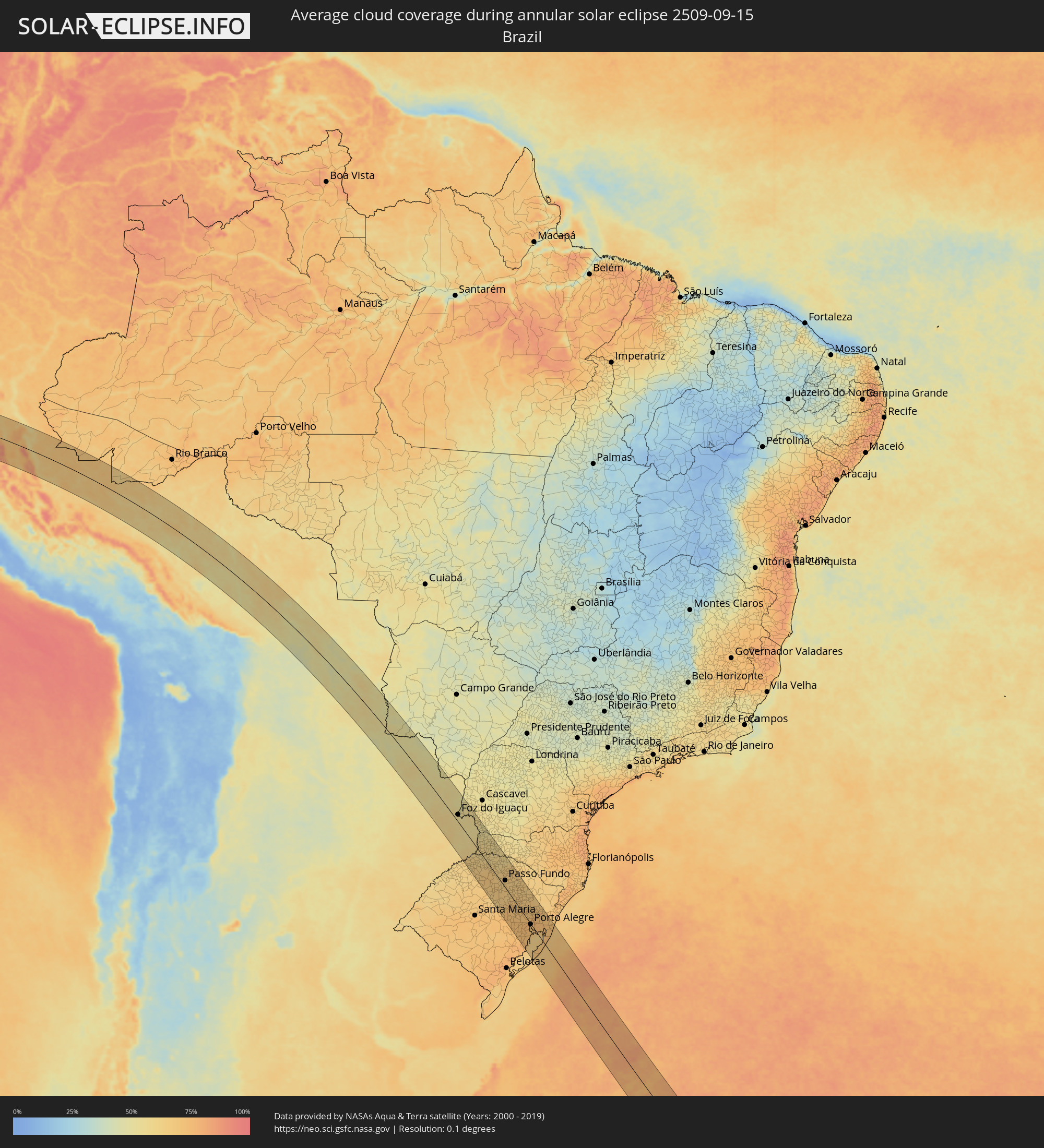 Brazil
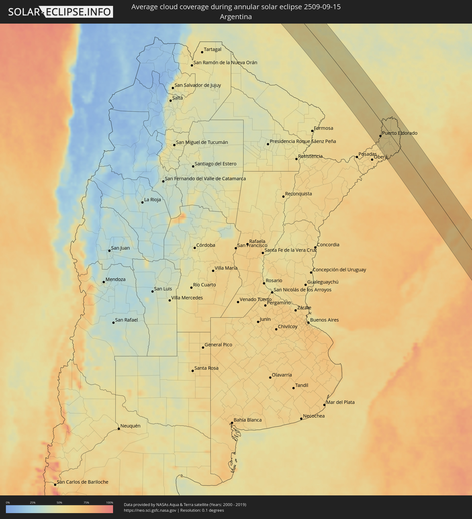 Argentina
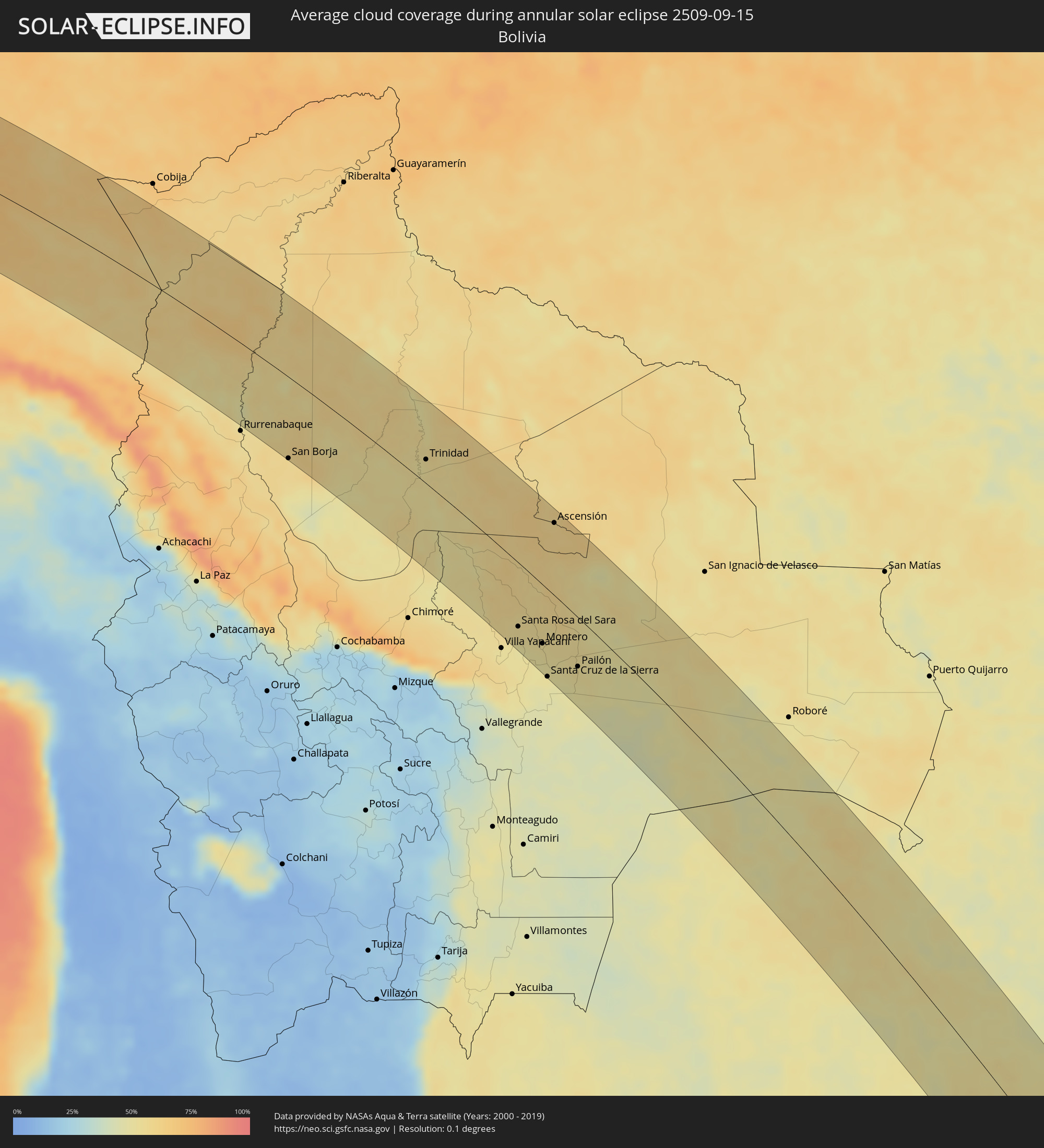 Bolivia
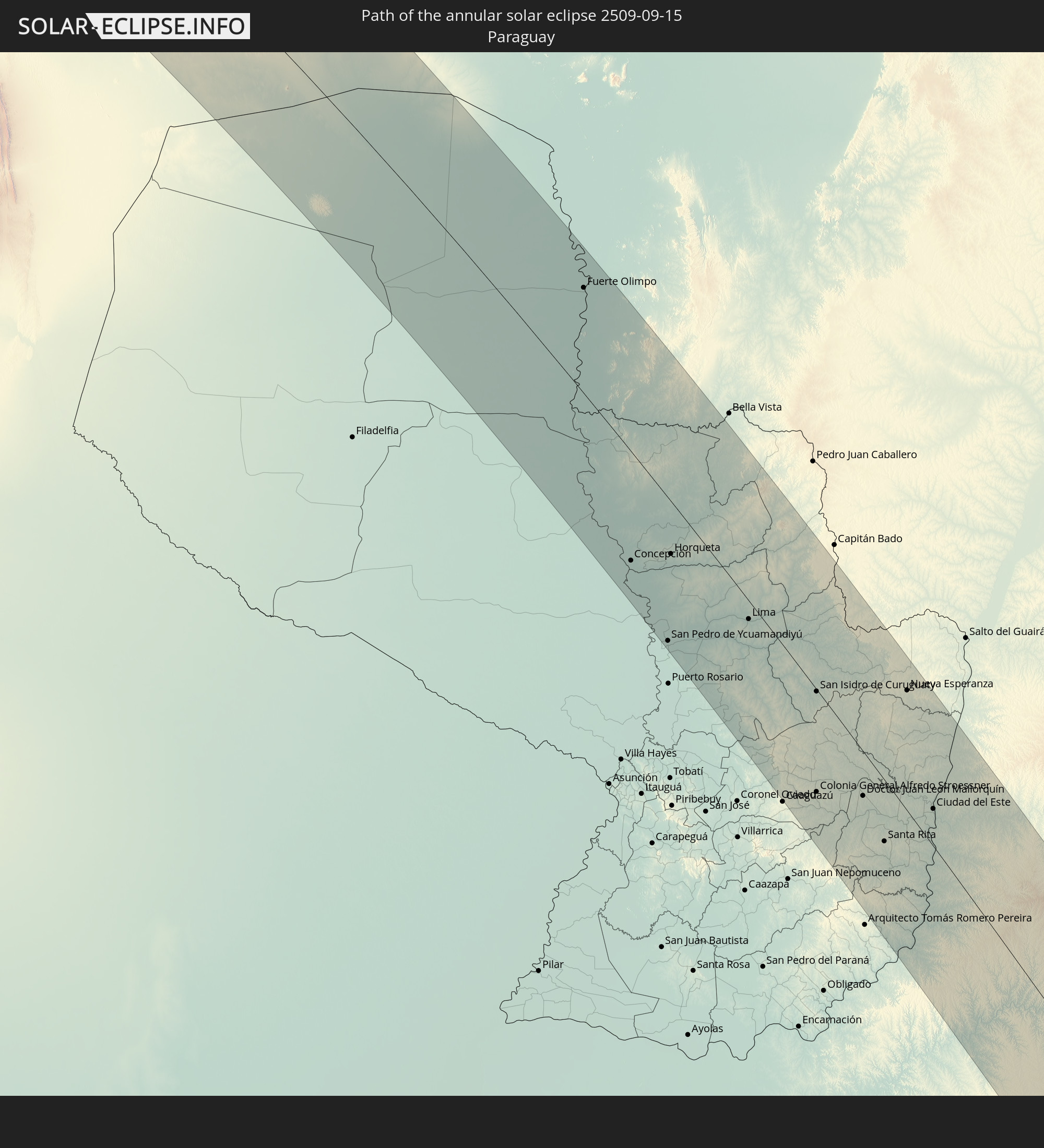
 Paraguay
Cities inside the path of the eclipse
The following table shows all locations with a population of more than 5,000 inside the eclipse path. Cities which have more than 100,000 inhabitants are marked bold. A click at the locations opens a detailed map.
| City | Type | Eclipse duration | Local time of max. eclipse | Distance to central line | Ø Cloud coverage |
|
Pimentel, Lambayeque
|
annular | - | 07:53:28 UTC-05:00 | 85 km | 62% |
|
Monsefú, Lambayeque
|
annular | - | 07:53:35 UTC-05:00 | 83 km | 60% |
|
Eten, Lambayeque
|
annular | - | 07:53:38 UTC-05:00 | 79 km | 60% |
|
Chiclayo, Lambayeque
|
annular | - | 07:53:26 UTC-05:00 | 94 km | 58% |
|
San José, Lambayeque
|
annular | - | 07:53:24 UTC-05:00 | 98 km | 61% |
|
Santa Rosa, Lambayeque
|
annular | - | 07:53:26 UTC-05:00 | 96 km | 58% |
|
Reque, Lambayeque
|
annular | - | 07:53:37 UTC-05:00 | 85 km | 54% |
|
Saña, Lambayeque
|
annular | - | 07:53:55 UTC-05:00 | 86 km | 51% |
|
Pacasmayo, La Libertad
|
annular | - | 07:54:42 UTC-05:00 | 35 km | 55% |
|
San Pedro de Lloc, La Libertad
|
annular | - | 07:54:49 UTC-05:00 | 34 km | 51% |
|
Pacanga, La Libertad
|
annular | - | 07:54:23 UTC-05:00 | 62 km | 54% |
|
Guadalupe, La Libertad
|
annular | - | 07:54:32 UTC-05:00 | 54 km | 54% |
|
Chepén, La Libertad
|
annular | - | 07:54:33 UTC-05:00 | 58 km | 49% |
|
Paiján, La Libertad
|
annular | - | 07:55:30 UTC-05:00 | 7 km | 67% |
|
Oyotún, Lambayeque
|
annular | - | 07:54:03 UTC-05:00 | 103 km | 49% |
|
Santiago de Cao, La Libertad
|
annular | - | 07:55:56 UTC-05:00 | 15 km | 69% |
|
Chocope, La Libertad
|
annular | - | 07:55:41 UTC-05:00 | 4 km | 60% |
|
Chicama, La Libertad
|
annular | - | 07:55:50 UTC-05:00 | 0 km | 39% |
|
Ascope, La Libertad
|
annular | - | 07:55:40 UTC-05:00 | 15 km | 43% |
|
Trujillo, La Libertad
|
annular | - | 07:56:24 UTC-05:00 | 25 km | 64% |
|
Moche, La Libertad
|
annular | - | 07:56:31 UTC-05:00 | 30 km | 65% |
|
Salaverry, La Libertad
|
annular | - | 07:56:38 UTC-05:00 | 35 km | 65% |
|
Laredo, La Libertad
|
annular | - | 07:56:26 UTC-05:00 | 20 km | 64% |
|
Virú, La Libertad
|
annular | - | 07:57:11 UTC-05:00 | 48 km | 63% |
|
Puerto Santa, Ancash
|
annular | - | 07:58:16 UTC-05:00 | 106 km | 66% |
|
Coishco, Ancash
|
annular | - | 07:58:21 UTC-05:00 | 108 km | 66% |
|
Otuzco, La Libertad
|
annular | - | 07:56:28 UTC-05:00 | 12 km | 45% |
|
Cajamarca, Cajamarca
|
annular | - | 07:55:20 UTC-05:00 | 93 km | 57% |
|
Quiruvilca, La Libertad
|
annular | - | 07:56:58 UTC-05:00 | 18 km | 59% |
|
Santiago de Chuco, La Libertad
|
annular | - | 07:57:17 UTC-05:00 | 0 km | 55% |
|
Huamachuco, La Libertad
|
annular | - | 07:56:49 UTC-05:00 | 40 km | 58% |
|
Cajabamba, Cajamarca
|
annular | - | 07:56:31 UTC-05:00 | 60 km | 53% |
|
Carás, Ancash
|
annular | - | 07:59:13 UTC-05:00 | 83 km | 38% |
|
Yauya, Ancash
|
annular | - | 07:59:39 UTC-05:00 | 59 km | 63% |
|
Tocache, San Martín
|
annular | - | 07:59:05 UTC-05:00 | 53 km | 61% |
|
Uchiza, San Martín
|
annular | - | 07:59:37 UTC-05:00 | 27 km | 66% |
|
Tingo María, Huanuco
|
annular | - | 08:01:37 UTC-05:00 | 42 km | 63% |
|
Campoverde, Ucayali
|
annular | - | 08:01:29 UTC-05:00 | 90 km | 78% |
|
Tambopata, Madre de Dios
|
annular | - | 08:16:42 UTC-05:00 | 57 km | 61% |
|
Puerto Maldonado, Madre de Dios
|
annular | - | 08:16:46 UTC-05:00 | 40 km | 57% |
|
Reyes, El Beni
|
annular | - | 09:23:09 UTC-04:00 | 85 km | 53% |
|
San Borja, El Beni
|
annular | - | 09:25:02 UTC-04:00 | 100 km | 58% |
|
Trinidad, El Beni
|
annular | - | 09:28:10 UTC-04:00 | 28 km | 54% |
|
Santa Rosa del Sara, Santa Cruz
|
annular | - | 09:35:27 UTC-04:00 | 71 km | 54% |
|
Portachuelo, Santa Cruz
|
annular | - | 09:36:20 UTC-04:00 | 77 km | 50% |
|
Montero, Santa Cruz
|
annular | - | 09:36:33 UTC-04:00 | 65 km | 52% |
|
Mineros, Santa Cruz
|
annular | - | 09:36:05 UTC-04:00 | 46 km | 54% |
|
La Bélgica, Santa Cruz
|
annular | - | 09:37:05 UTC-04:00 | 80 km | 49% |
|
Santa Cruz de la Sierra, Santa Cruz
|
annular | - | 09:37:42 UTC-04:00 | 96 km | 50% |
|
Warnes, Santa Cruz
|
annular | - | 09:37:06 UTC-04:00 | 73 km | 51% |
|
Ascensión, Santa Cruz
|
annular | - | 09:33:05 UTC-04:00 | 81 km | 60% |
|
Cotoca, Santa Cruz
|
annular | - | 09:37:59 UTC-04:00 | 89 km | 49% |
|
San Julian, Santa Cruz
|
annular | - | 09:38:13 UTC-04:00 | 73 km | 50% |
|
Pailón, Santa Cruz
|
annular | - | 09:38:07 UTC-04:00 | 54 km | 53% |
|
Fuerte Olimpo, Alto Paraguay
|
annular | - | 10:54:35 UTC-03:00 | 65 km | 48% |
|
Concepción, Concepción
|
annular | - | 11:00:55 UTC-03:00 | 65 km | 54% |
|
San Pedro de Ycuamandiyú, San Pedro
|
annular | - | 11:03:08 UTC-03:00 | 84 km | 53% |
|
Horqueta, Concepción
|
annular | - | 11:01:27 UTC-03:00 | 31 km | 55% |
|
Lima, San Pedro
|
annular | - | 11:04:04 UTC-03:00 | 11 km | 53% |
|
San Isidro de Curuguaty, Canindeyú
|
annular | - | 11:06:39 UTC-03:00 | 1 km | 54% |
|
Colonia General Alfredo Stroessner, Caaguazú
|
annular | - | 11:08:36 UTC-03:00 | 58 km | 58% |
|
Doctor Juan León Mallorquín, Alto Paraná
|
annular | - | 11:09:28 UTC-03:00 | 25 km | 56% |
|
Santa Rita, Alto Paraná
|
annular | - | 11:10:42 UTC-03:00 | 34 km | 59% |
|
Nueva Esperanza, Canindeyú
|
annular | - | 11:08:10 UTC-03:00 | 68 km | 54% |
|
El Alcázar, Misiones Province
|
annular | - | 11:13:17 UTC-03:00 | 75 km | 55% |
|
Montecarlo, Misiones Province
|
annular | - | 11:13:03 UTC-03:00 | 60 km | 57% |
|
Puerto Piray, Misiones Province
|
annular | - | 11:12:54 UTC-03:00 | 51 km | 57% |
|
Puerto Eldorado, Misiones Province
|
annular | - | 11:12:48 UTC-03:00 | 45 km | 57% |
|
Dos de Mayo, Misiones Province
|
annular | - | 11:14:12 UTC-03:00 | 84 km | 58% |
|
Puerto Esperanza, Misiones Province
|
annular | - | 11:11:57 UTC-03:00 | 18 km | 58% |
|
Puerto Libertad, Misiones Province
|
annular | - | 11:11:49 UTC-03:00 | 7 km | 56% |
|
Presidente Franco, Alto Paraná
|
annular | - | 11:10:57 UTC-03:00 | 19 km | 53% |
|
Ciudad del Este, Alto Paraná
|
annular | - | 11:10:55 UTC-03:00 | 21 km | 53% |
|
Foz do Iguaçu, Paraná
|
annular | - | 11:11:02 UTC-03:00 | 20 km | 53% |
|
Puerto Iguazú, Misiones Province
|
annular | - | 11:11:11 UTC-03:00 | 18 km | 54% |
|
Colonia Wanda, Misiones Province
|
annular | - | 11:12:18 UTC-03:00 | 5 km | 56% |
|
El Soberbio, Misiones Province
|
annular | - | 11:15:42 UTC-03:00 | 63 km | 64% |
|
San Vicente, Misiones Province
|
annular | - | 11:14:18 UTC-03:00 | 13 km | 56% |
|
San Pedro, Misiones Province
|
annular | - | 11:14:21 UTC-03:00 | 12 km | 56% |
|
Medianeira, Paraná
|
annular | - | 11:11:22 UTC-03:00 | 77 km | 56% |
|
Bernardo de Irigoyen, Misiones Province
|
annular | - | 11:14:22 UTC-03:00 | 50 km | 55% |
|
Panambi, Rio Grande do Sul
|
annular | - | 11:19:11 UTC-03:00 | 71 km | 67% |
|
Frederico Westphalen, Rio Grande do Sul
|
annular | - | 11:17:18 UTC-03:00 | 2 km | 62% |
|
Palmeira das Missões, Rio Grande do Sul
|
annular | - | 11:18:39 UTC-03:00 | 30 km | 68% |
|
Carazinho, Rio Grande do Sul
|
annular | - | 11:20:27 UTC-03:00 | 13 km | 66% |
|
Chapecó, Santa Catarina
|
annular | - | 11:18:08 UTC-03:00 | 77 km | 57% |
|
Soledade, Rio Grande do Sul
|
annular | - | 11:22:07 UTC-03:00 | 25 km | 67% |
|
Santa Cruz do Sul, Rio Grande do Sul
|
annular | - | 11:24:13 UTC-03:00 | 75 km | 74% |
|
Passo Fundo, Rio Grande do Sul
|
annular | - | 11:21:06 UTC-03:00 | 19 km | 64% |
|
Erechim, Rio Grande do Sul
|
annular | - | 11:19:57 UTC-03:00 | 70 km | 64% |
|
Marau, Rio Grande do Sul
|
annular | - | 11:21:52 UTC-03:00 | 23 km | 65% |
|
Venâncio Aires, Rio Grande do Sul
|
annular | - | 11:24:24 UTC-03:00 | 50 km | 72% |
|
Butiá, Rio Grande do Sul
|
annular | - | 11:25:54 UTC-03:00 | 64 km | 73% |
|
Lajeado, Rio Grande do Sul
|
annular | - | 11:24:31 UTC-03:00 | 23 km | 69% |
|
Guaporé, Rio Grande do Sul
|
annular | - | 11:23:18 UTC-03:00 | 23 km | 67% |
|
Taquari, Rio Grande do Sul
|
annular | - | 11:25:24 UTC-03:00 | 36 km | 73% |
|
Teutônia, Rio Grande do Sul
|
annular | - | 11:24:45 UTC-03:00 | 9 km | 71% |
|
Charqueadas, Rio Grande do Sul
|
annular | - | 11:26:09 UTC-03:00 | 27 km | 74% |
|
Veranópolis, Rio Grande do Sul
|
annular | - | 11:24:06 UTC-03:00 | 44 km | 66% |
|
Garibaldi, Rio Grande do Sul
|
annular | - | 11:24:50 UTC-03:00 | 25 km | 69% |
|
Bento Gonçalves, Rio Grande do Sul
|
annular | - | 11:24:40 UTC-03:00 | 31 km | 68% |
|
Carlos Barbosa, Rio Grande do Sul
|
annular | - | 11:24:58 UTC-03:00 | 25 km | 69% |
|
Montenegro, Rio Grande do Sul
|
annular | - | 11:25:53 UTC-03:00 | 3 km | 73% |
|
Tapes, Rio Grande do Sul
|
annular | - | 11:28:05 UTC-03:00 | 54 km | 71% |
|
São Sebastião do Caí, Rio Grande do Sul
|
annular | - | 11:25:49 UTC-03:00 | 16 km | 70% |
|
Farroupilha, Rio Grande do Sul
|
annular | - | 11:25:06 UTC-03:00 | 42 km | 67% |
|
Portão, Rio Grande do Sul
|
annular | - | 11:26:18 UTC-03:00 | 19 km | 74% |
|
Porto Alegre, Rio Grande do Sul
|
annular | - | 11:27:02 UTC-03:00 | 1 km | 74% |
|
Flores da Cunha, Rio Grande do Sul
|
annular | - | 11:24:58 UTC-03:00 | 67 km | 68% |
|
Caxias do Sul, Rio Grande do Sul
|
annular | - | 11:25:17 UTC-03:00 | 59 km | 68% |
|
Sapucaia, Rio Grande do Sul
|
annular | - | 11:26:45 UTC-03:00 | 18 km | 75% |
|
Novo Hamburgo, Rio Grande do Sul
|
annular | - | 11:26:27 UTC-03:00 | 30 km | 74% |
|
São Marcos, Rio Grande do Sul
|
annular | - | 11:25:03 UTC-03:00 | 80 km | 67% |
|
Viamão, Rio Grande do Sul
|
annular | - | 11:27:30 UTC-03:00 | 13 km | 75% |
|
Gravataí, Rio Grande do Sul
|
annular | - | 11:27:16 UTC-03:00 | 24 km | 75% |
|
Parobé, Rio Grande do Sul
|
annular | - | 11:26:53 UTC-03:00 | 56 km | 72% |
|
Canela, Rio Grande do Sul
|
annular | - | 11:26:20 UTC-03:00 | 76 km | 69% |
|
Igrejinha, Rio Grande do Sul
|
annular | - | 11:26:51 UTC-03:00 | 63 km | 72% |
|
Três Coroas, Rio Grande do Sul
|
annular | - | 11:26:45 UTC-03:00 | 68 km | 71% |