Total solar eclipse of 12/09/2569
| Day of week: | Saturday |
| Maximum duration of eclipse: | 03m27s |
| Maximum width of eclipse path: | 155 km |
| Saros cycle: | 151 |
| Coverage: | 100% |
| Magnitude: | 1.0431 |
| Gamma: | -0.3687 |
Wo kann man die Sonnenfinsternis vom 12/09/2569 sehen?
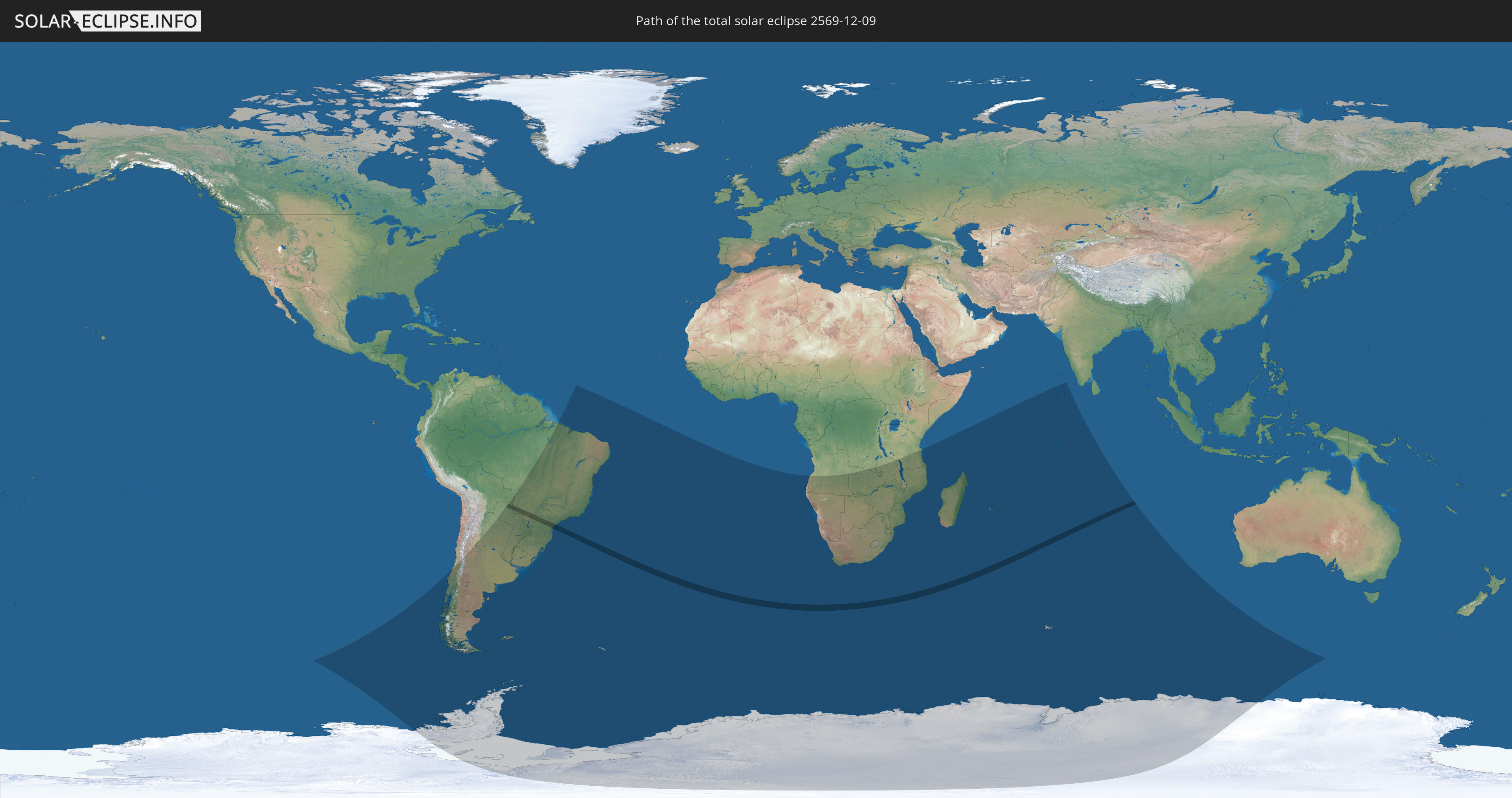
Die Sonnenfinsternis am 12/09/2569 kann man in 33 Ländern als partielle Sonnenfinsternis beobachten.
Der Finsternispfad verläuft durch 2 Länder. Nur in diesen Ländern ist sie als total Sonnenfinsternis zu sehen.
In den folgenden Ländern ist die Sonnenfinsternis total zu sehen
 Brazil
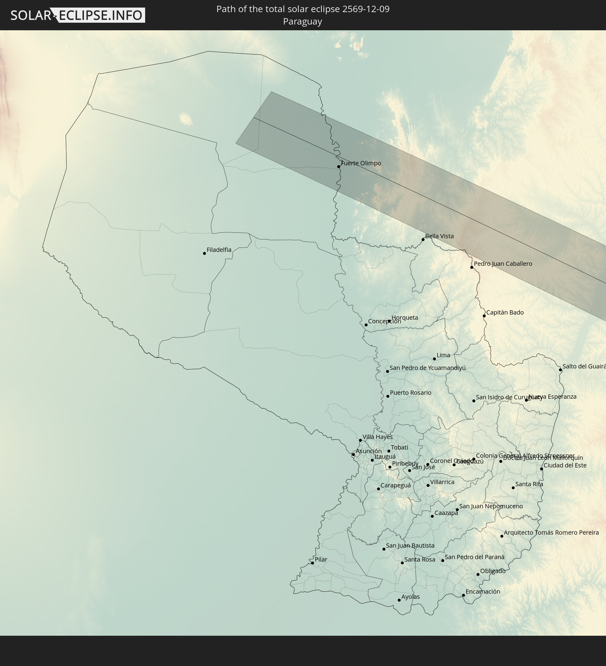 Paraguay
In den folgenden Ländern ist die Sonnenfinsternis partiell zu sehen
 Antarctica
 Chile
Chile
 Brazil
 Argentina
 Bolivia
 Paraguay
 Falkland Islands
 Uruguay
 South Georgia and the South Sandwich Islands
 Saint Helena, Ascension and Tristan da Cunha
 Bouvet Island
 Angola
 Namibia
 Democratic Republic of the Congo
 South Africa
 Botswana
 Zambia
 Zimbabwe
 Lesotho
 Tanzania
 Mozambique
 Swaziland
 Malawi
 French Southern and Antarctic Lands
 Madagascar
 Comoros
 Mayotte
 Seychelles
 Réunion
 Mauritius
 British Indian Ocean Territory
 Heard Island and McDonald Islands
 Maldives
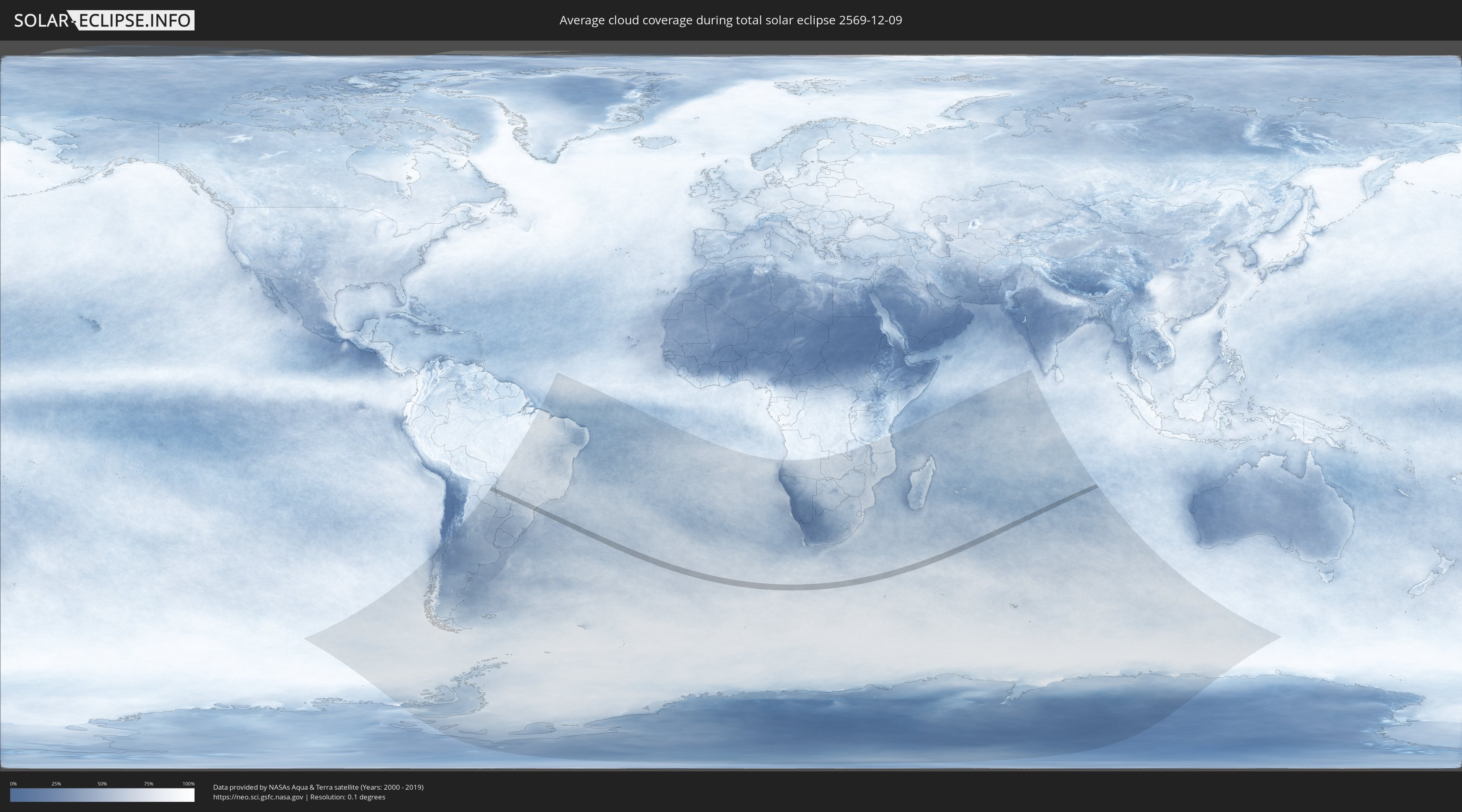
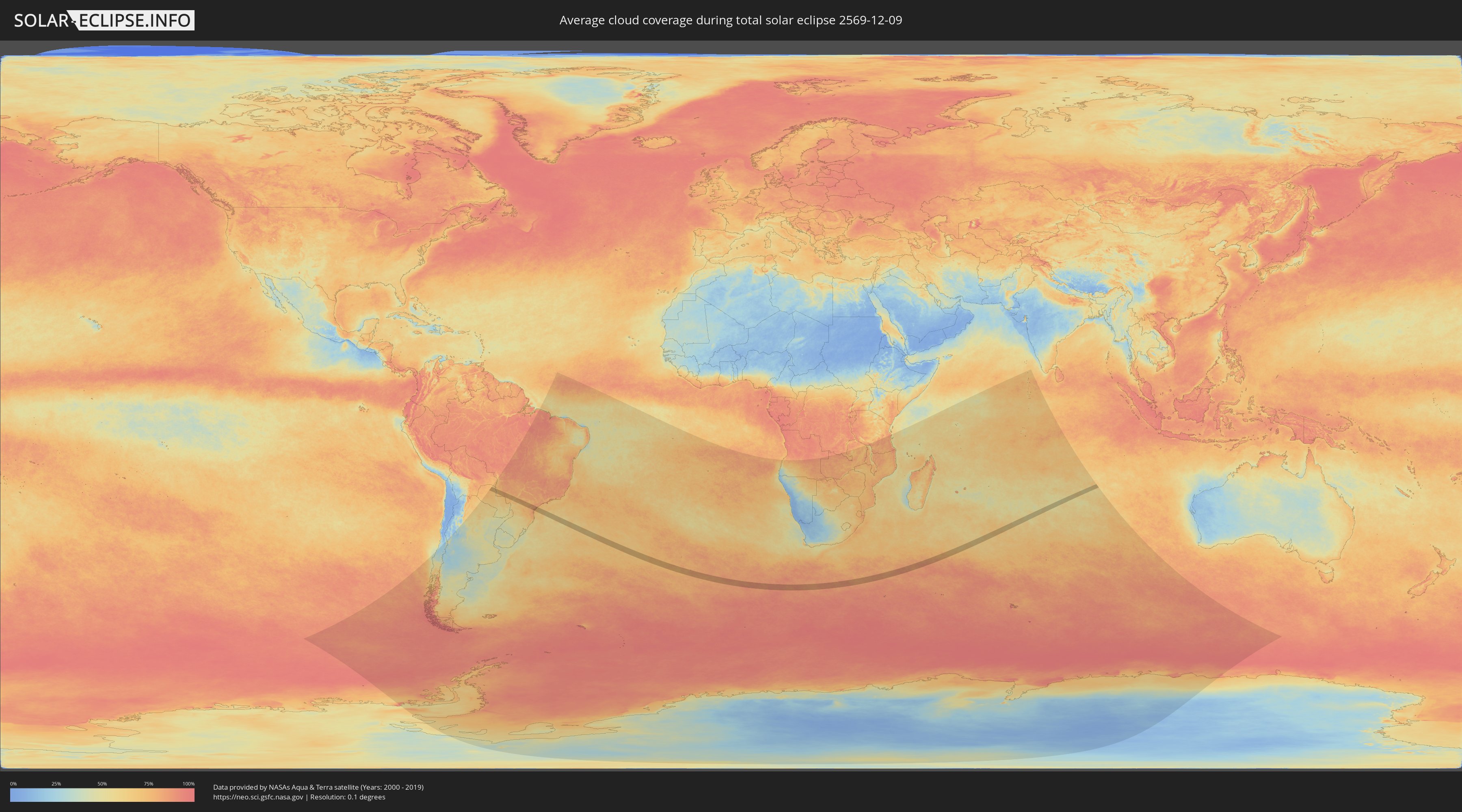
How will be the weather during the total solar eclipse on 12/09/2569?
Where is the best place to see the total solar eclipse of 12/09/2569?
The following maps show the average cloud coverage for the day of the total solar eclipse.
With the help of these maps, it is possible to find the place along the eclipse path, which has the best
chance of a cloudless sky.
Nevertheless, you should consider local circumstances and inform about the weather of your chosen
observation site.
The data is provided by NASAs satellites
AQUA and TERRA.
The cloud maps are averaged over a period of 19 years (2000 - 2019).
Detailed country maps
 Brazil
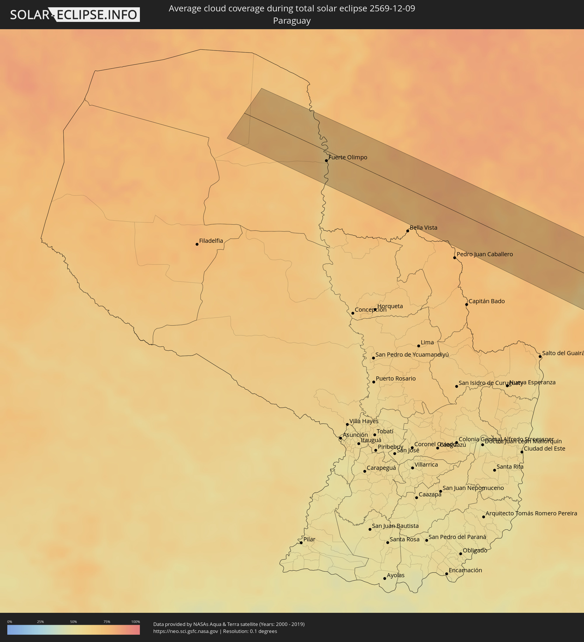 Paraguay
Cities inside the path of the eclipse
The following table shows all locations with a population of more than 5,000 inside the eclipse path. Cities which have more than 100,000 inhabitants are marked bold. A click at the locations opens a detailed map.
| City | Type | Eclipse duration | Local time of max. eclipse | Distance to central line | Ø Cloud coverage |
|
Fuerte Olimpo, Alto Paraguay
|
total | - | 06:12:53 UTC-03:00 | 16 km | 64% |
|
Bonito, Mato Grosso do Sul
|
total | - | 05:12:34 UTC-04:00 | 37 km | 75% |
|
Jardim, Mato Grosso do Sul
|
total | - | 05:12:46 UTC-04:00 | 16 km | 78% |
|
Guia Lopes da Laguna, Mato Grosso do Sul
|
total | - | 05:12:45 UTC-04:00 | 20 km | 78% |
|
Maracaju, Mato Grosso do Sul
|
total | - | 05:12:39 UTC-04:00 | 46 km | 76% |
|
Caarapó, Mato Grosso do Sul
|
total | - | 05:13:27 UTC-04:00 | 41 km | 69% |
|
Dourados, Mato Grosso do Sul
|
total | - | 05:13:05 UTC-04:00 | 1 km | 76% |
|
Rio Brilhante, Mato Grosso do Sul
|
total | - | 05:12:41 UTC-04:00 | 55 km | 72% |
|
Pôrto Barra do Ivinheima, Mato Grosso do Sul
|
total | - | 05:13:31 UTC-04:00 | 23 km | 65% |
|
Loanda, Paraná
|
total | - | 06:13:23 UTC-03:00 | 5 km | 75% |
|
Nova Londrina, Paraná
|
total | - | 06:13:13 UTC-03:00 | 28 km | 77% |
|
Terra Rica, Paraná
|
total | - | 06:13:07 UTC-03:00 | 50 km | 77% |
|
Cianorte, Paraná
|
total | - | 06:13:58 UTC-03:00 | 45 km | 72% |
|
Nova Aurora, Paraná
|
total | - | 06:13:15 UTC-03:00 | 37 km | 77% |
|
Paranavaí, Paraná
|
total | - | 06:13:25 UTC-03:00 | 21 km | 76% |
|
Terra Boa, Paraná
|
total | - | 06:14:03 UTC-03:00 | 48 km | 68% |
|
Alto Paraná, Paraná
|
total | - | 06:13:26 UTC-03:00 | 22 km | 75% |
|
Engenheiro Beltrão, Paraná
|
total | - | 06:14:03 UTC-03:00 | 43 km | 68% |
|
Mandaguaçu, Paraná
|
total | - | 06:13:36 UTC-03:00 | 10 km | 76% |
|
Paiçandu, Paraná
|
total | - | 06:13:42 UTC-03:00 | 1 km | 74% |
|
Maringá, Paraná
|
total | - | 06:13:39 UTC-03:00 | 9 km | 78% |
|
Sarandi, Paraná
|
total | - | 06:13:40 UTC-03:00 | 10 km | 78% |
|
Marialva, Paraná
|
total | - | 06:13:42 UTC-03:00 | 10 km | 76% |
|
Mandaguari, Paraná
|
total | - | 06:13:44 UTC-03:00 | 9 km | 77% |
|
Astorga, Paraná
|
total | - | 06:13:27 UTC-03:00 | 41 km | 77% |
|
Jandaia do Sul, Paraná
|
total | - | 06:13:47 UTC-03:00 | 5 km | 77% |
|
Apucarana, Paraná
|
total | - | 06:13:43 UTC-03:00 | 18 km | 78% |
|
Arapongas, Paraná
|
total | - | 06:13:35 UTC-03:00 | 33 km | 79% |
|
Rolândia, Paraná
|
total | - | 06:13:29 UTC-03:00 | 46 km | 78% |
|
Faxinal, Paraná
|
total | - | 06:14:07 UTC-03:00 | 20 km | 75% |
|
Cambé, Paraná
|
total | - | 06:13:26 UTC-03:00 | 54 km | 79% |
|
Londrina, Paraná
|
total | - | 06:13:27 UTC-03:00 | 56 km | 80% |
|
Ortigueira, Paraná
|
total | - | 06:14:16 UTC-03:00 | 24 km | 77% |
|
Telêmaco Borba, Paraná
|
total | - | 06:14:21 UTC-03:00 | 20 km | 77% |
|
Tibagi, Paraná
|
total | - | 06:14:30 UTC-03:00 | 30 km | 75% |
|
Ibaiti, Paraná
|
total | - | 06:13:51 UTC-03:00 | 46 km | 76% |
|
Terra Roxa, Paraná
|
total | - | 06:13:51 UTC-03:00 | 53 km | 75% |
|
Castro, Paraná
|
total | - | 06:14:45 UTC-03:00 | 39 km | 78% |
|
Piraí do Sul, Paraná
|
total | - | 06:14:29 UTC-03:00 | 10 km | 79% |
|
Jaguariaíva, Paraná
|
total | - | 06:14:12 UTC-03:00 | 29 km | 76% |
|
Sengés, Paraná
|
total | - | 06:14:03 UTC-03:00 | 53 km | 76% |
|
Itaperuçu, Paraná
|
total | - | 06:15:07 UTC-03:00 | 52 km | 77% |
|
Rio Branco do Sul, Paraná
|
total | - | 06:15:05 UTC-03:00 | 47 km | 77% |
|
Colombo, Paraná
|
total | - | 06:15:11 UTC-03:00 | 53 km | 78% |
|
Quatro Barras, Paraná
|
total | - | 06:15:15 UTC-03:00 | 54 km | 77% |
|
Campina Grande do Sul, Paraná
|
total | - | 06:15:12 UTC-03:00 | 47 km | 78% |
|
Apiaí, São Paulo
|
total | - | 06:14:24 UTC-03:00 | 42 km | 83% |
|
Antonina, Paraná
|
total | - | 06:15:18 UTC-03:00 | 43 km | 79% |
|
Paranaguá, Paraná
|
total | - | 06:15:23 UTC-03:00 | 43 km | 75% |
|
Pontal do Paraná, Paraná
|
total | - | 06:15:32 UTC-03:00 | 58 km | 79% |
|
Cajati, São Paulo
|
total | - | 06:14:36 UTC-03:00 | 52 km | 83% |
|
Cananéia, São Paulo
|
total | - | 06:14:52 UTC-03:00 | 34 km | 75% |