Total solar eclipse of 07/28/2595
| Day of week: | Tuesday |
| Maximum duration of eclipse: | 03m30s |
| Maximum width of eclipse path: | 116 km |
| Saros cycle: | 155 |
| Coverage: | 100% |
| Magnitude: | 1.0343 |
| Gamma: | -0.0539 |
Wo kann man die Sonnenfinsternis vom 07/28/2595 sehen?
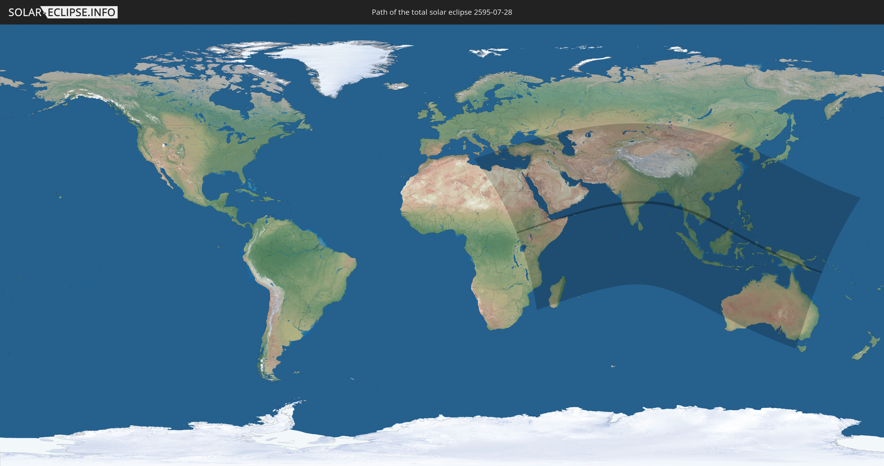
Die Sonnenfinsternis am 07/28/2595 kann man in 83 Ländern als partielle Sonnenfinsternis beobachten.
Der Finsternispfad verläuft durch 13 Länder. Nur in diesen Ländern ist sie als total Sonnenfinsternis zu sehen.
In den folgenden Ländern ist die Sonnenfinsternis total zu sehen
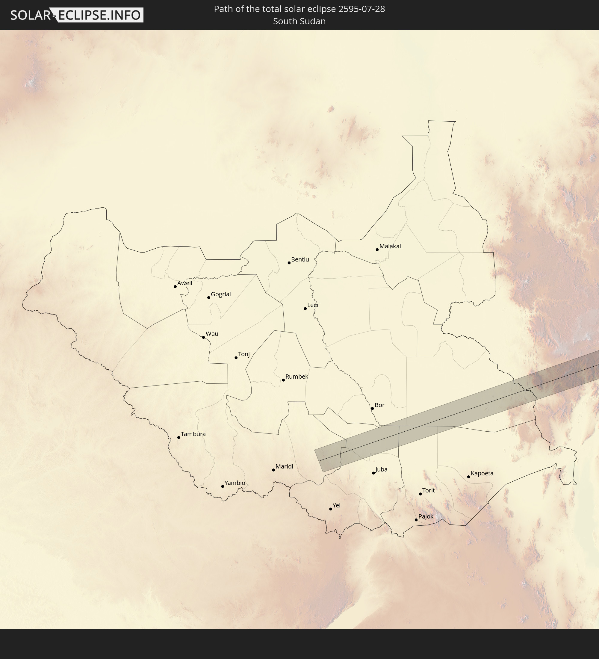 South Sudan
 Ethiopia
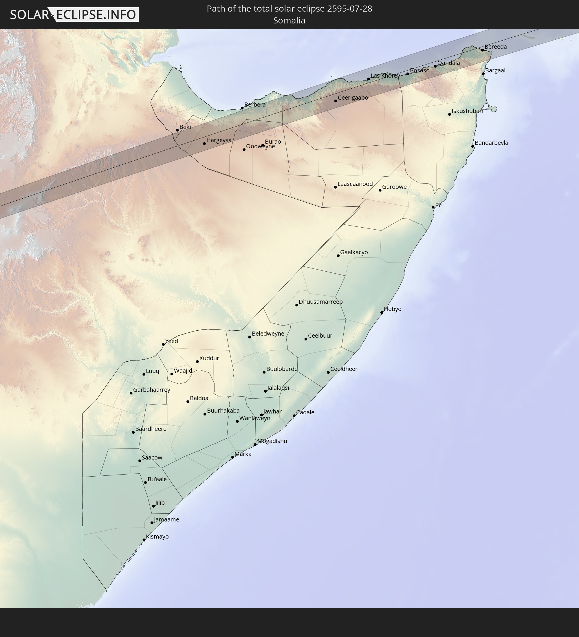 Somalia
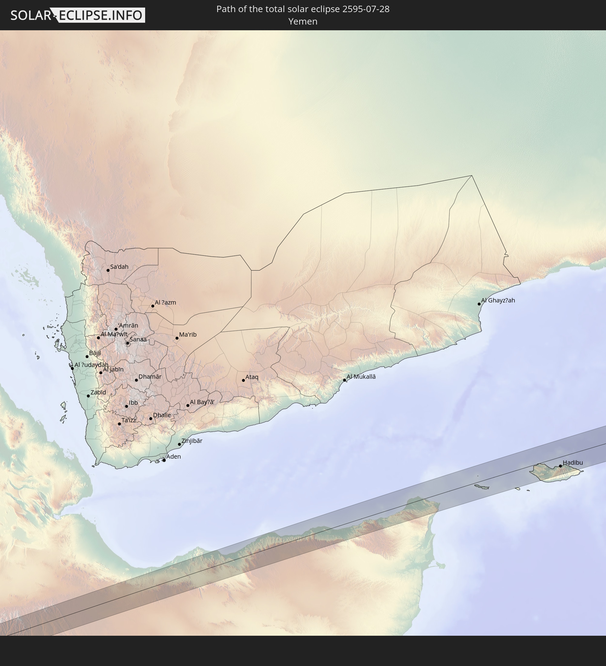 Yemen
Yemen
 India
India
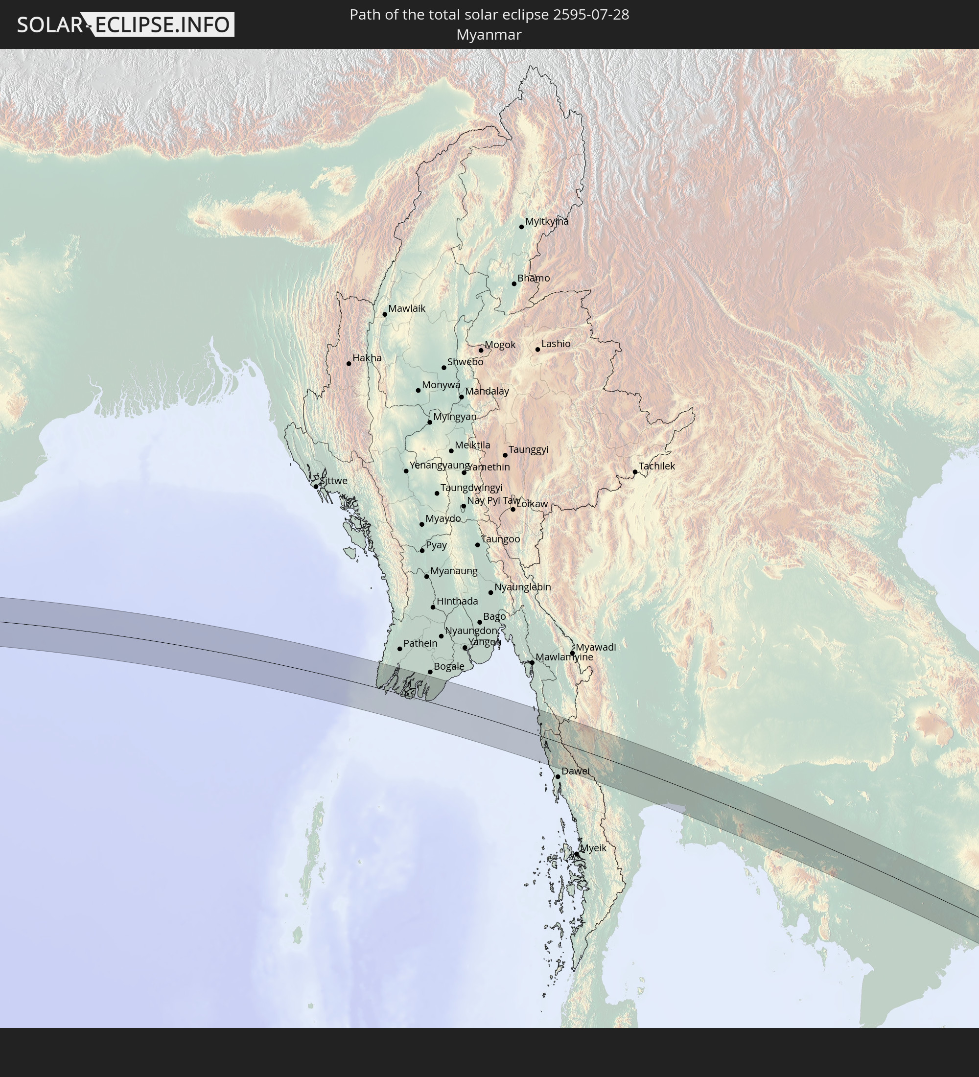 Myanmar
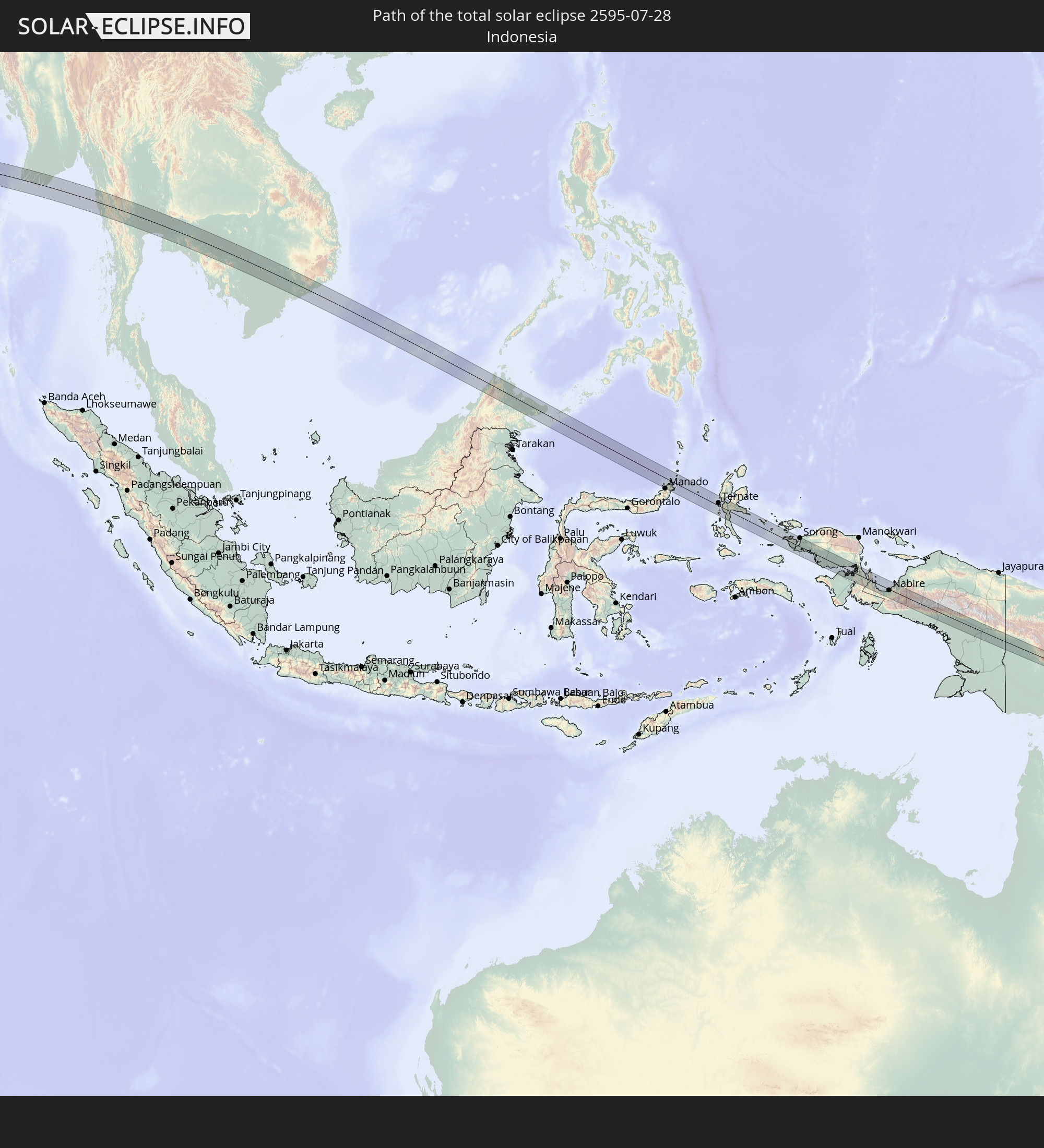 Indonesia
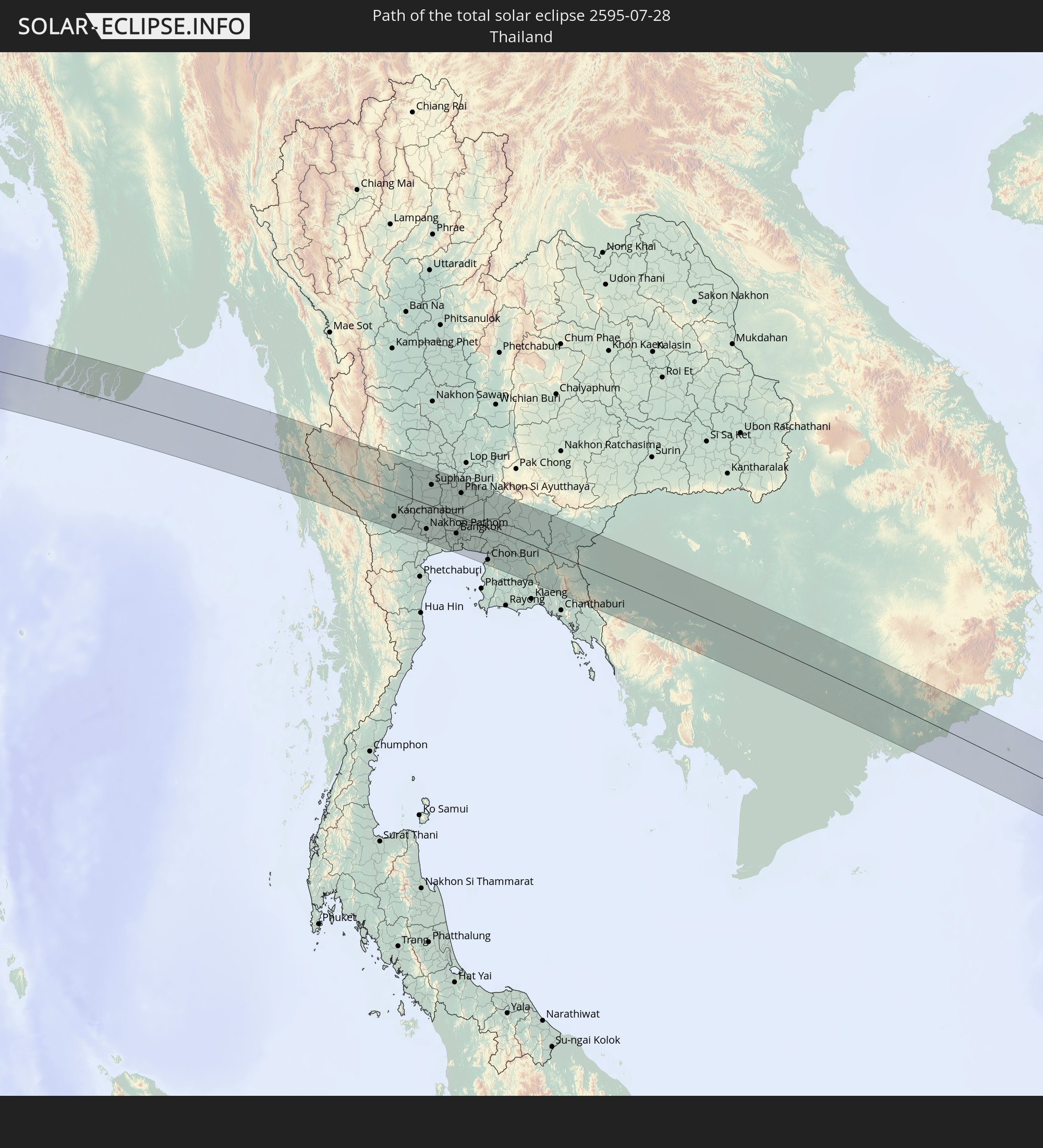 Thailand
 Malaysia
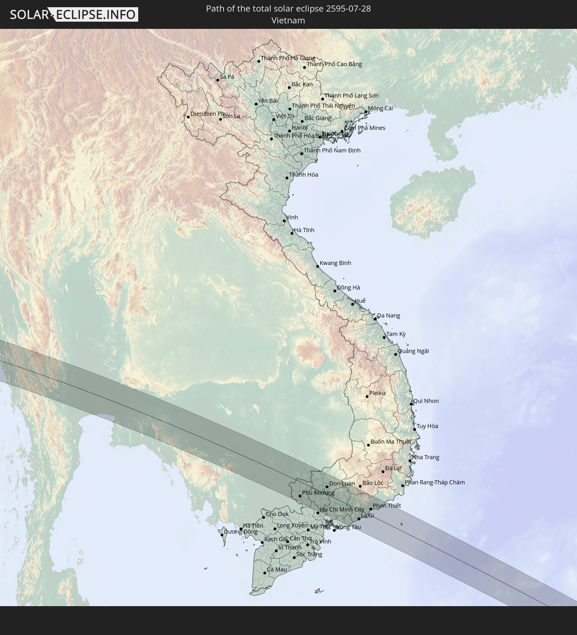 Vietnam
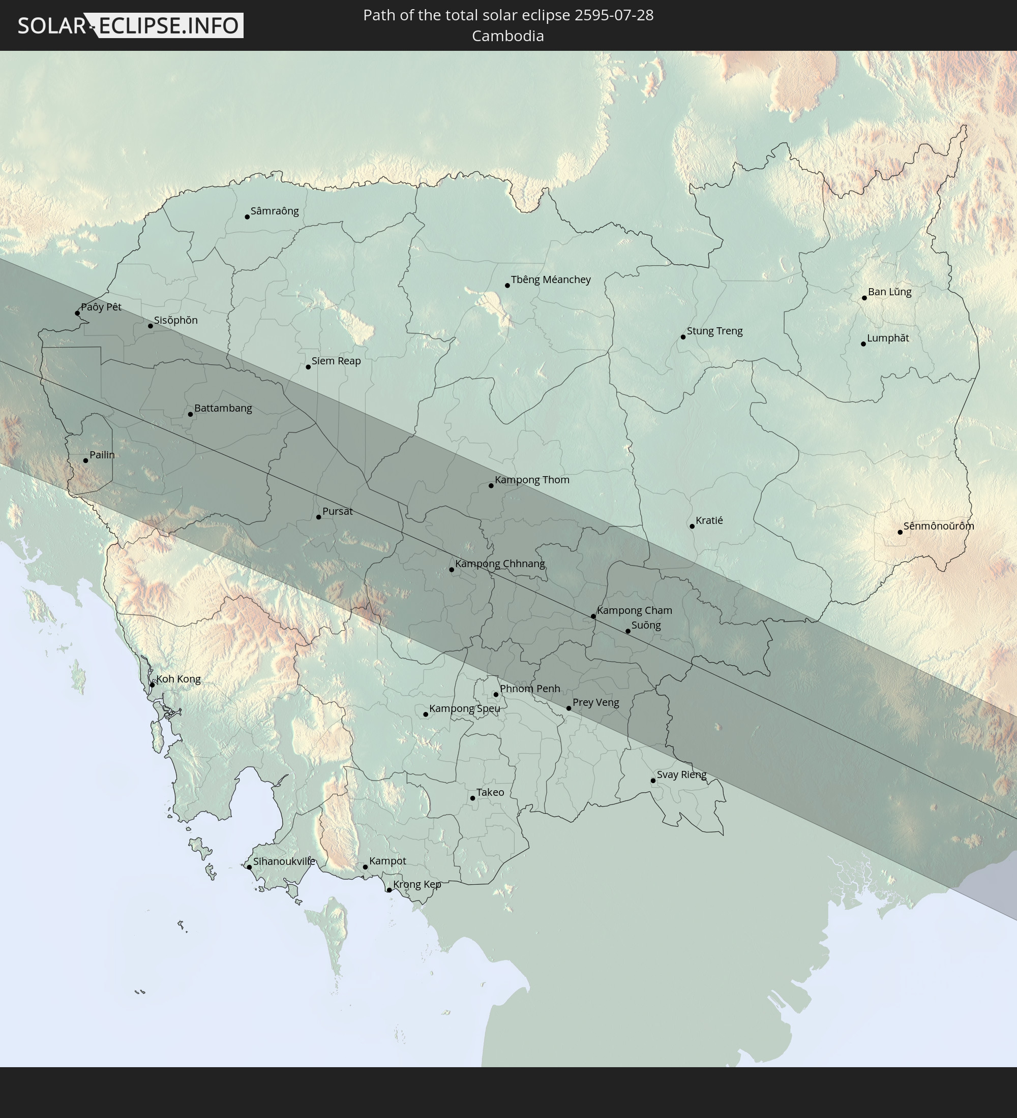 Cambodia
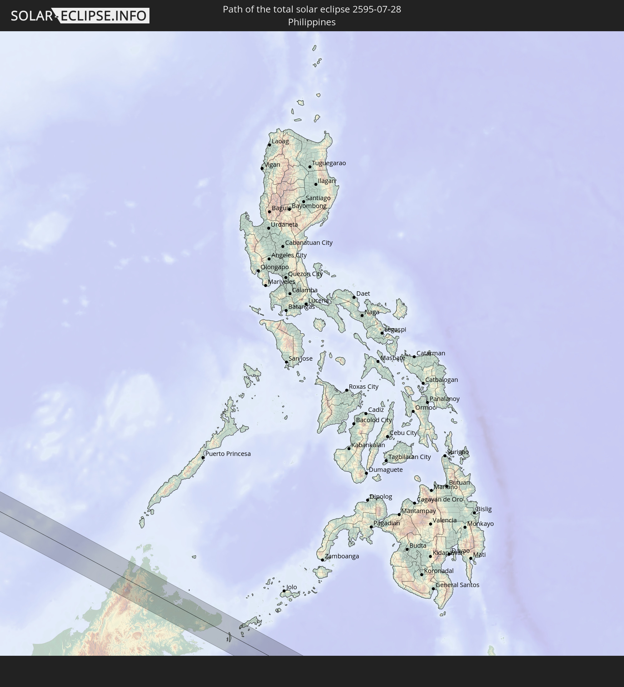 Philippines
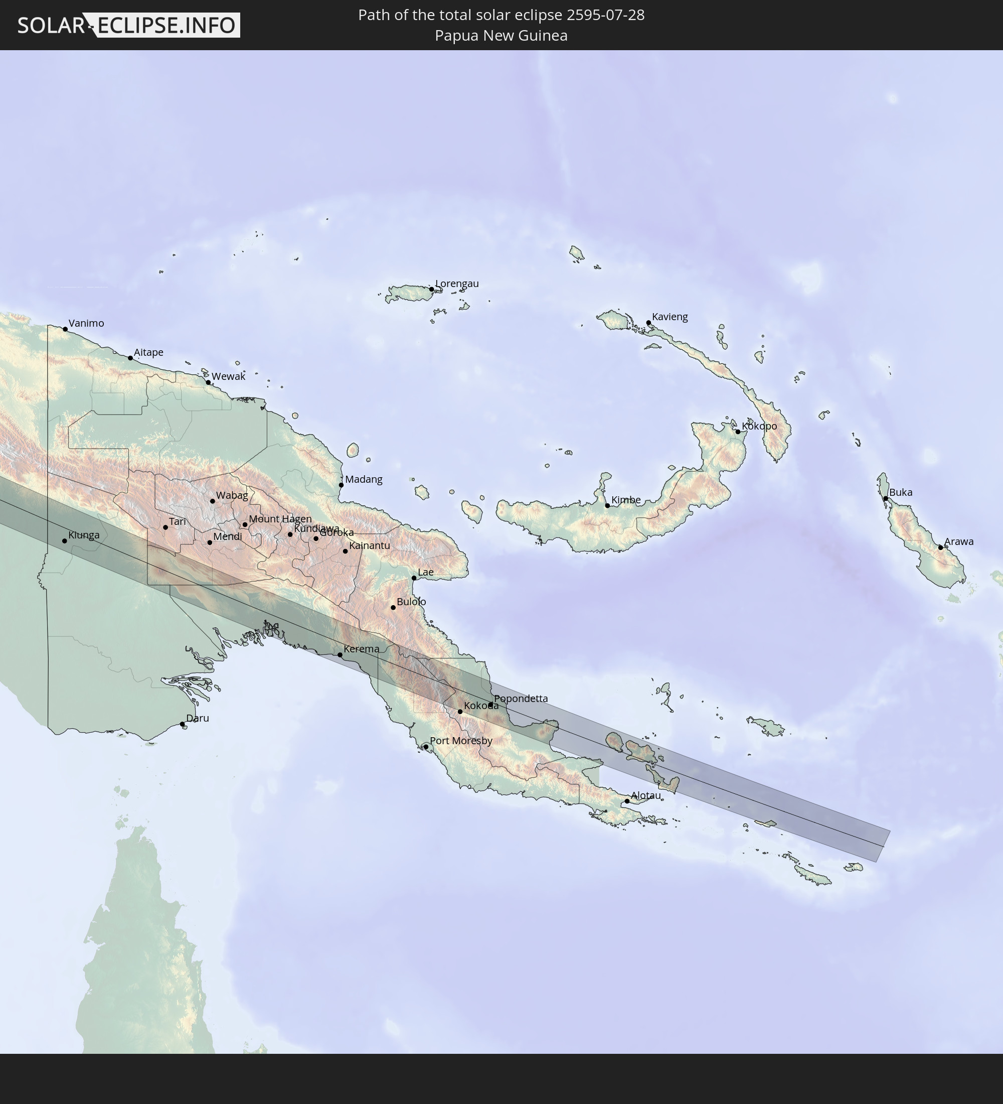 Papua New Guinea
In den folgenden Ländern ist die Sonnenfinsternis partiell zu sehen
 Russia
 United States Minor Outlying Islands
 Libya
Libya
 Chad
Chad
 Greece
 Sudan
Sudan
 Egypt
Egypt
 Turkey
 Tanzania
 Uganda
 Mozambique
 Cyprus
 Ethiopia
 Kenya
Kenya
 State of Palestine
 Israel
 Saudi Arabia
 Jordan
 Lebanon
 Syria
Syria
 Eritrea
 Iraq
Iraq
 Georgia
 French Southern and Antarctic Lands
 Somalia
 Djibouti
 Yemen
Yemen
 Madagascar
 Comoros
 Armenia
 Iran
Iran
 Azerbaijan
 Mayotte
 Seychelles
 Kazakhstan
 Kuwait
 Bahrain
 Qatar
Qatar
 United Arab Emirates
 Oman
Oman
 Turkmenistan
 Uzbekistan
 Mauritius
 Afghanistan
 Pakistan
 Tajikistan
 India
India
 Kyrgyzstan
 British Indian Ocean Territory
 Maldives
 China
China
 Sri Lanka
 Nepal
Nepal
 Mongolia
 Bangladesh
 Bhutan
 Myanmar
 Indonesia
 Cocos Islands
 Thailand
 Malaysia
 Laos
Laos
 Vietnam
 Cambodia
 Singapore
 Christmas Island
 Australia
 Macau
Macau
 Hong Kong
 Brunei
 Taiwan
 Philippines
 Japan
Japan
 East Timor
 North Korea
 South Korea
 Palau
Palau
 Federated States of Micronesia
 Papua New Guinea
 Guam
Guam
 Northern Mariana Islands
 Solomon Islands
 Marshall Islands
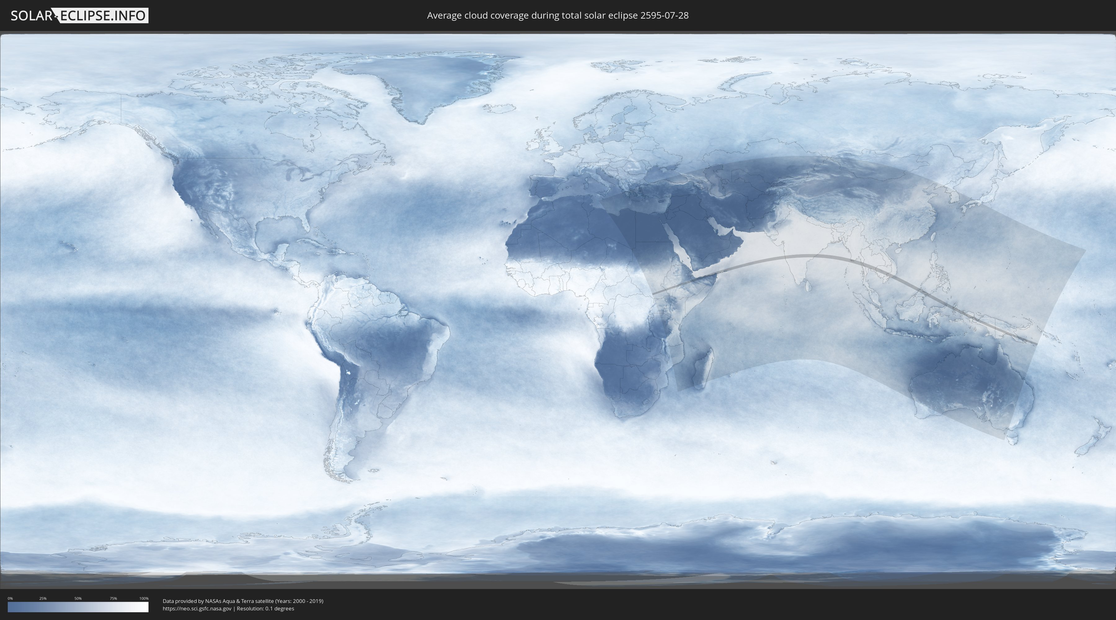
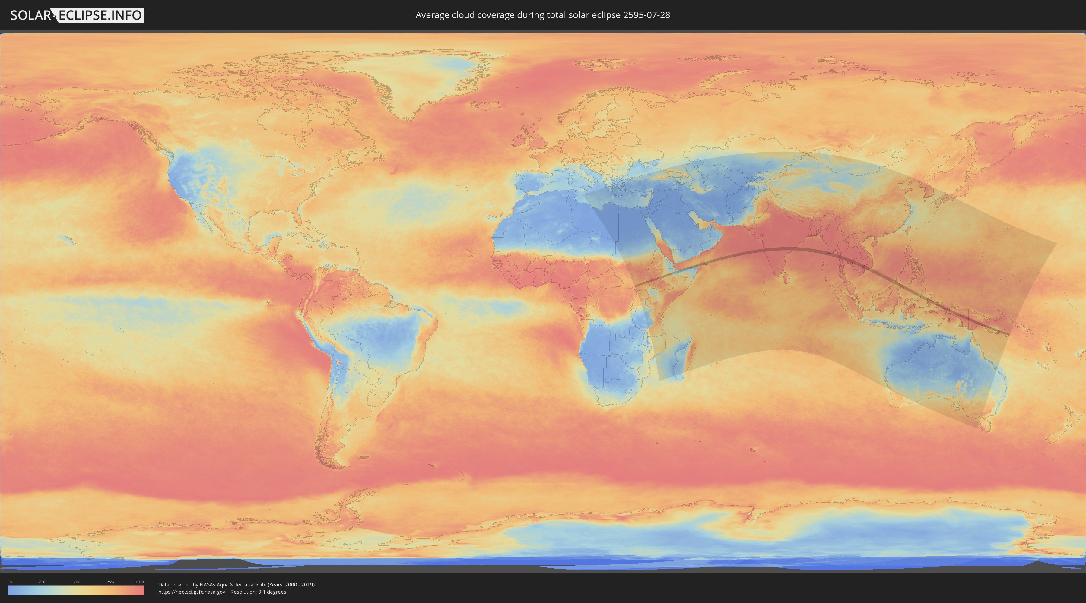
How will be the weather during the total solar eclipse on 07/28/2595?
Where is the best place to see the total solar eclipse of 07/28/2595?
The following maps show the average cloud coverage for the day of the total solar eclipse.
With the help of these maps, it is possible to find the place along the eclipse path, which has the best
chance of a cloudless sky.
Nevertheless, you should consider local circumstances and inform about the weather of your chosen
observation site.
The data is provided by NASAs satellites
AQUA and TERRA.
The cloud maps are averaged over a period of 19 years (2000 - 2019).
Detailed country maps
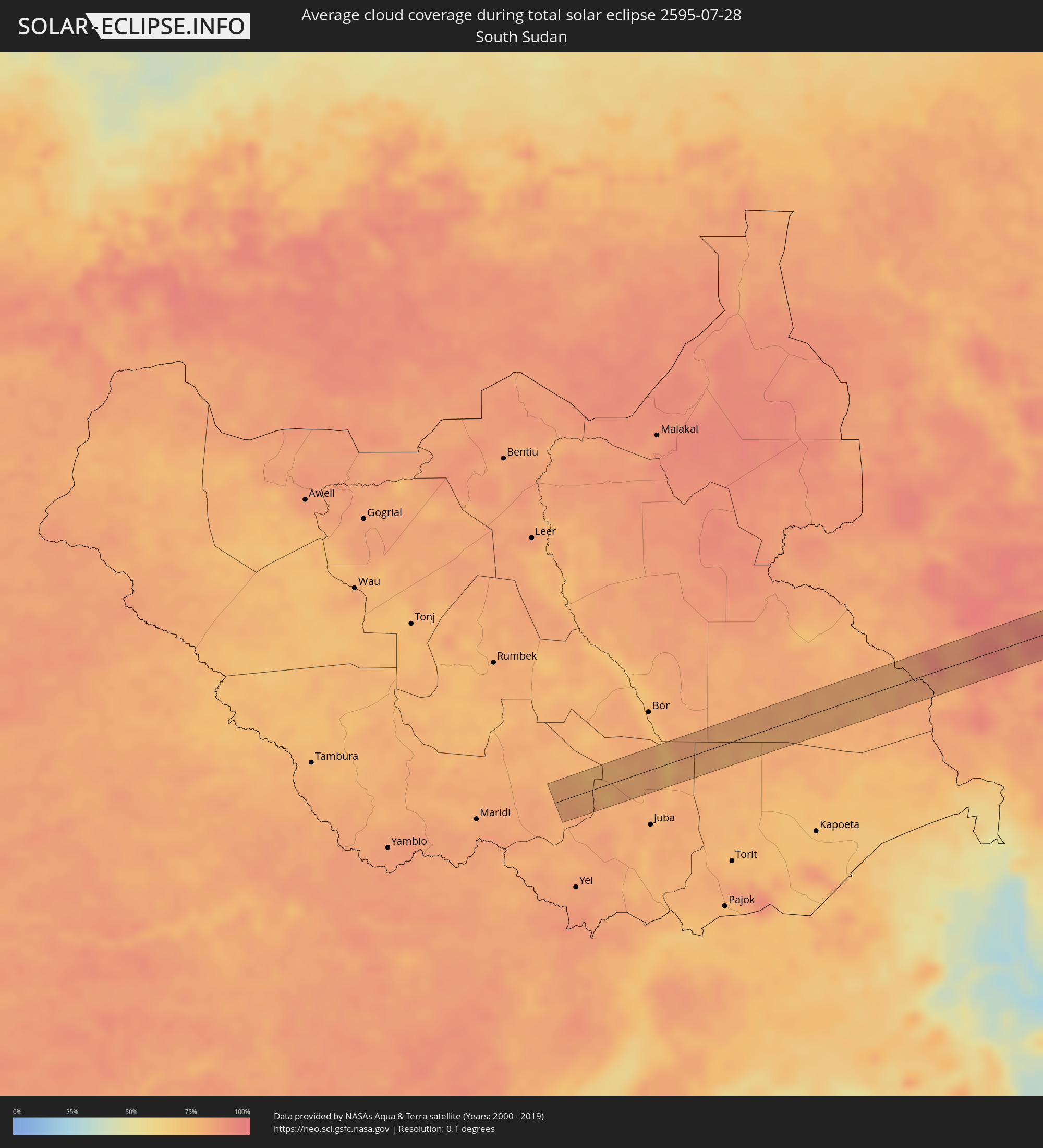 South Sudan
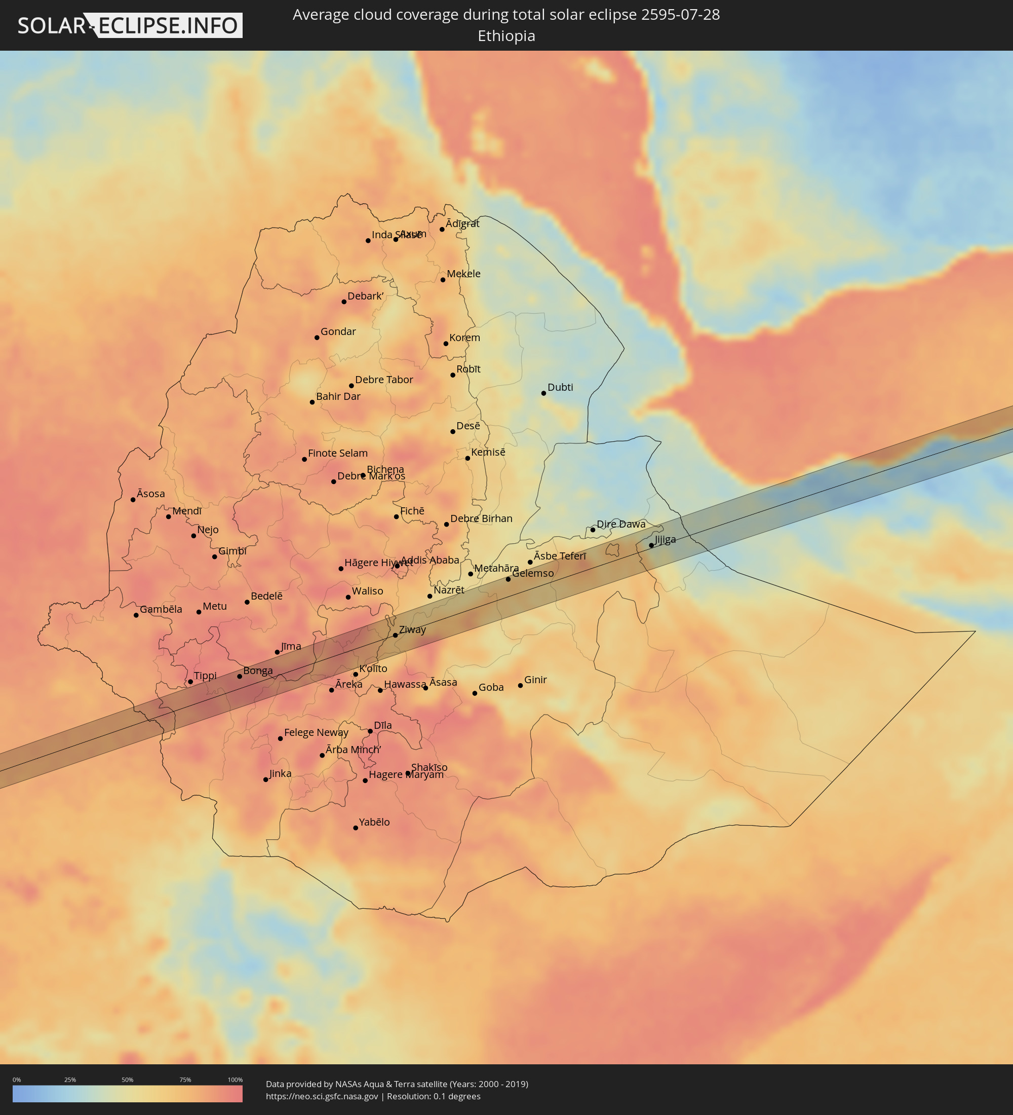 Ethiopia
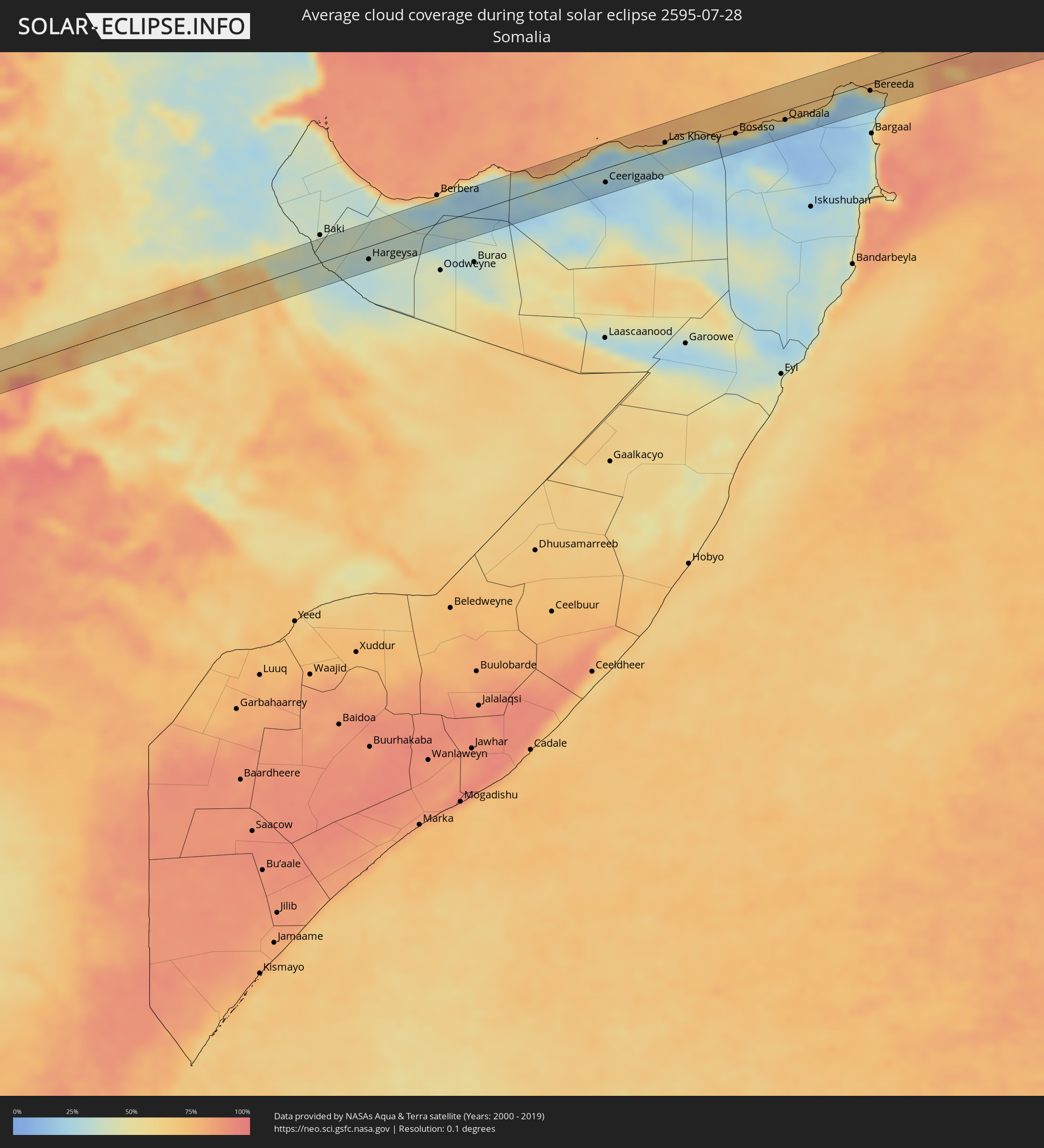 Somalia
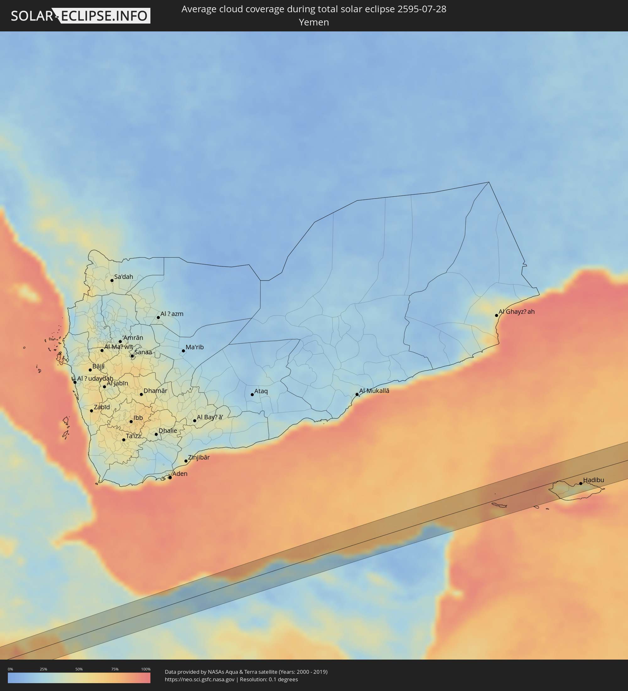 Yemen
Yemen
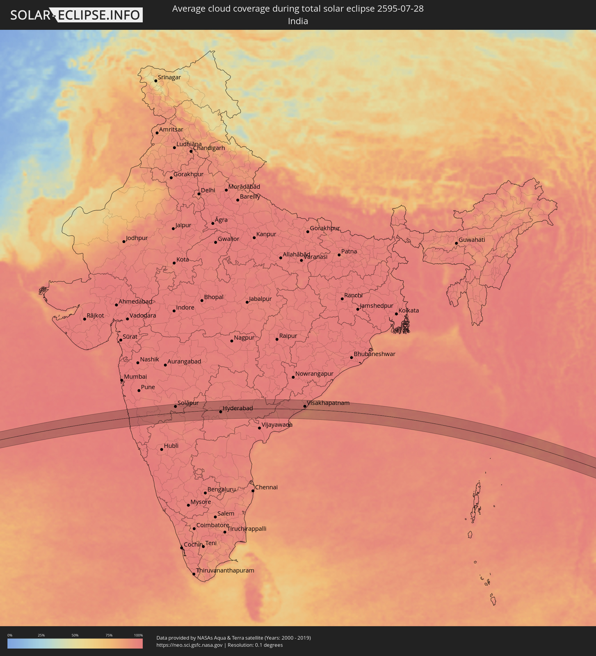 India
India
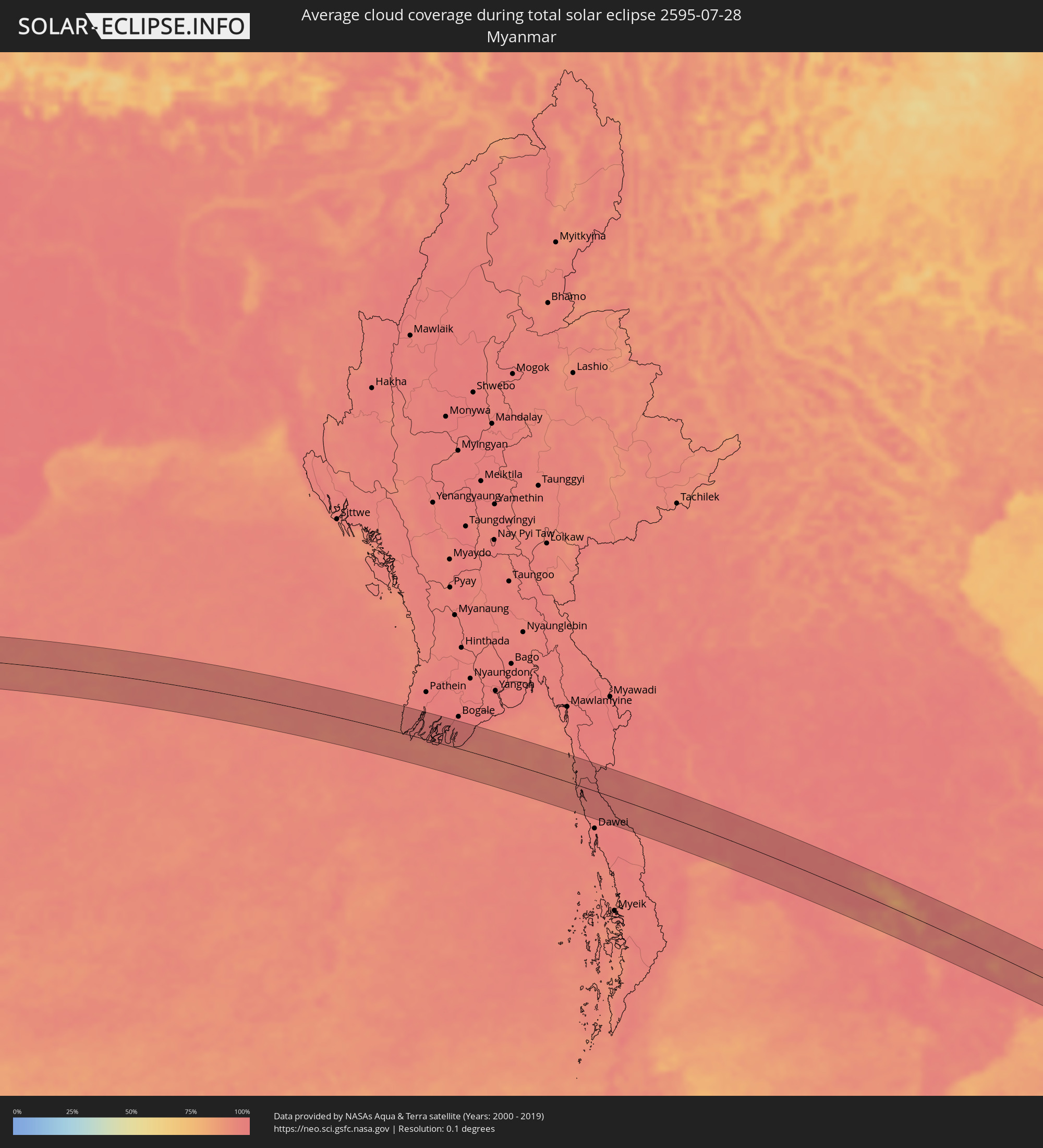 Myanmar
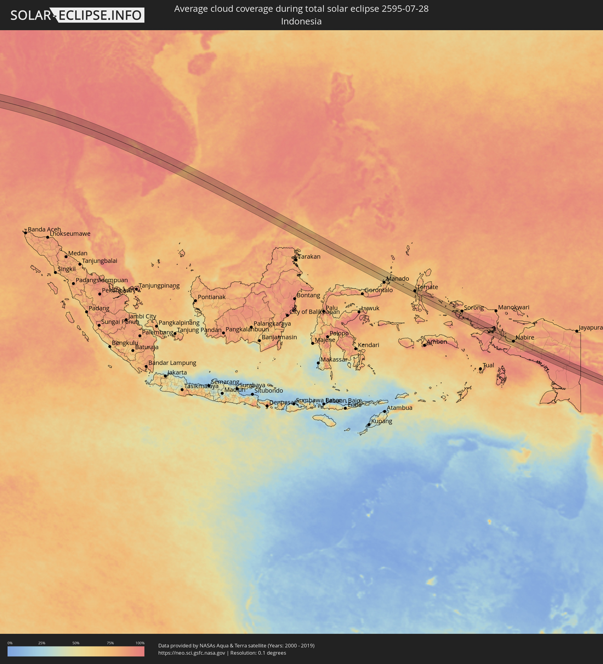 Indonesia
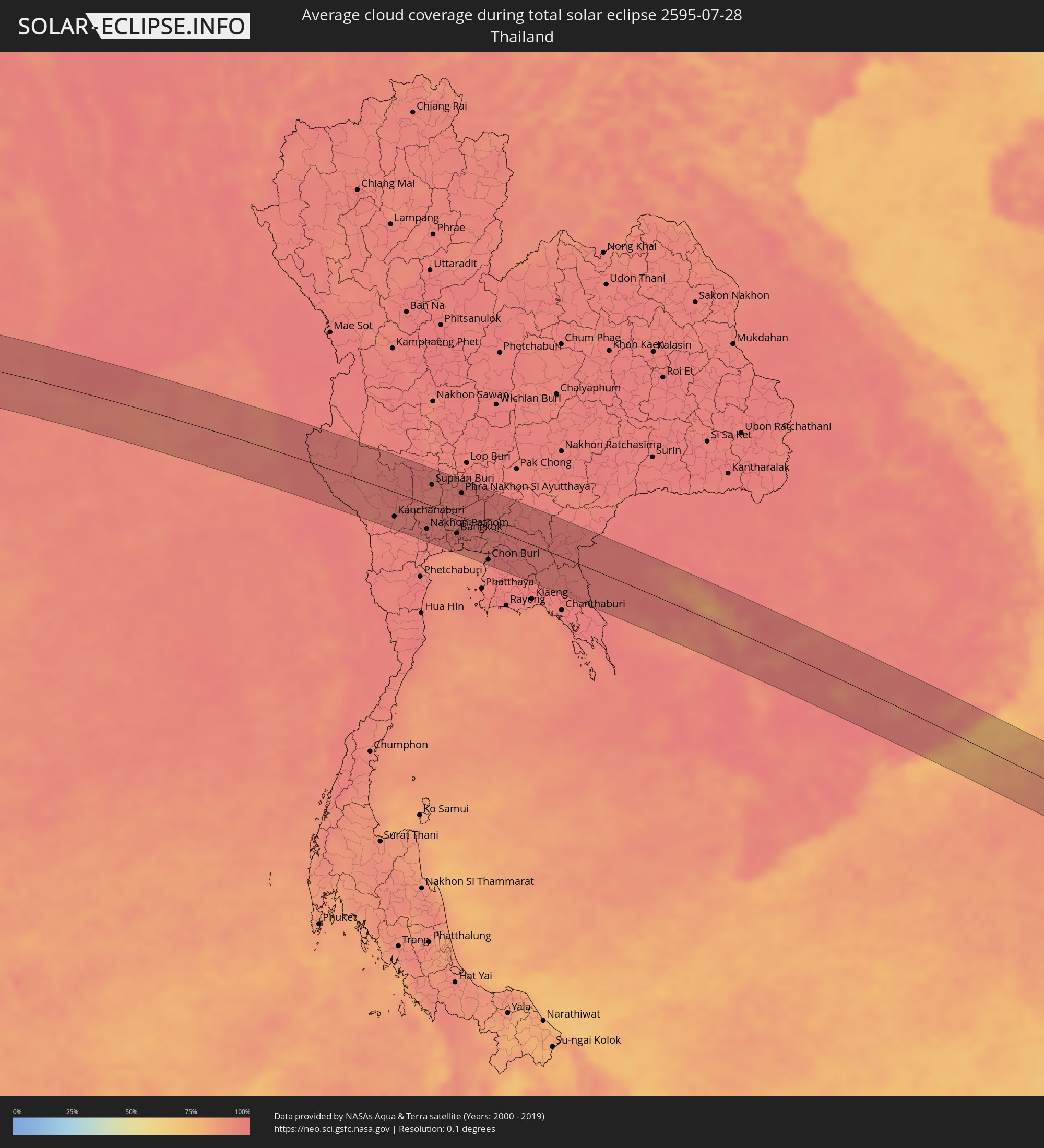 Thailand
 Malaysia
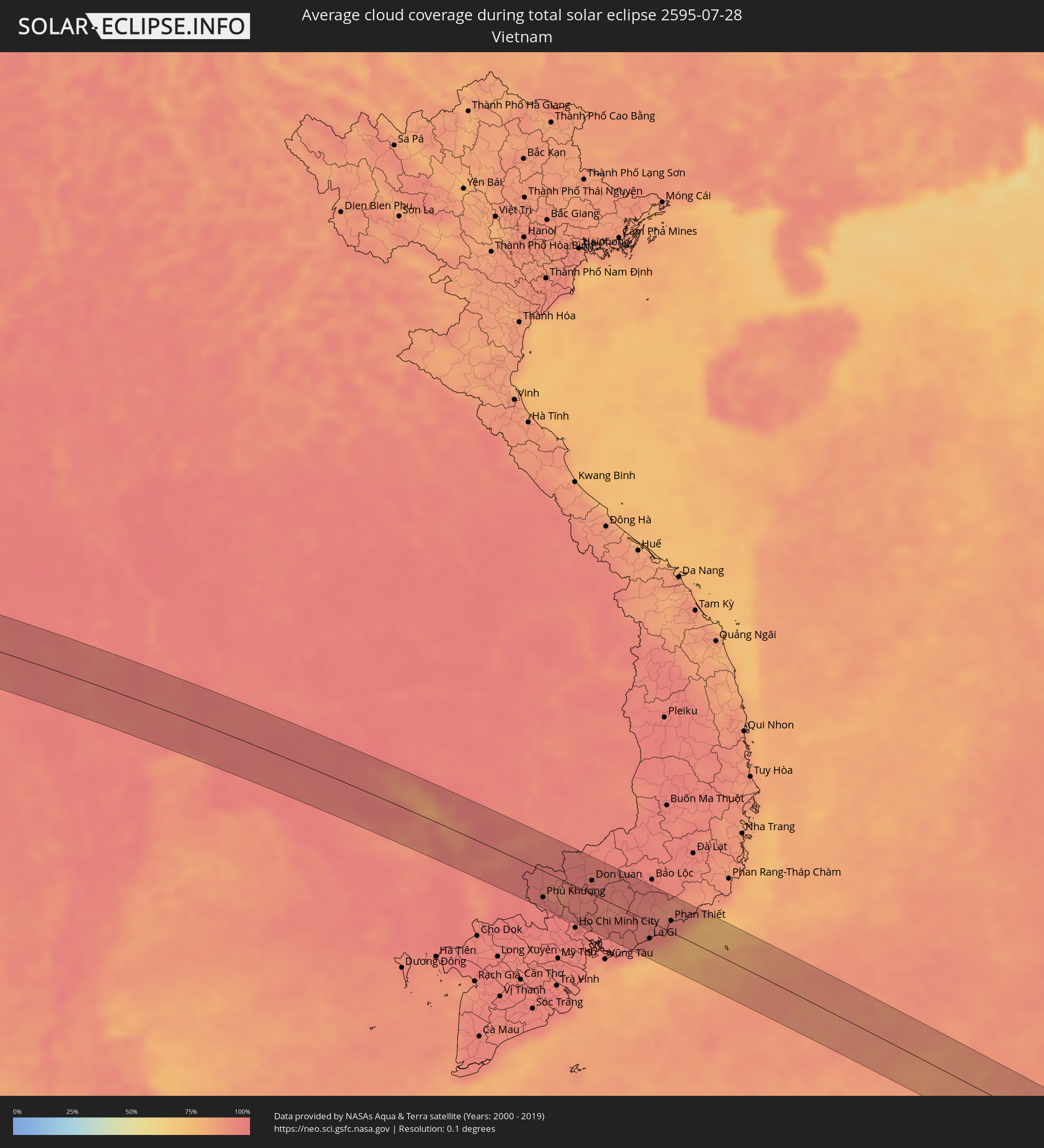 Vietnam
 Cambodia
 Philippines
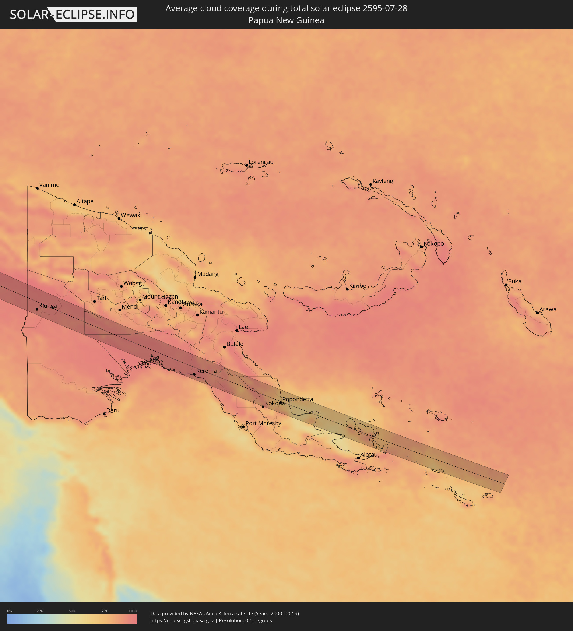 Papua New Guinea
Cities inside the path of the eclipse
The following table shows all locations with a population of more than 5,000 inside the eclipse path. Cities which have more than 100,000 inhabitants are marked bold. A click at the locations opens a detailed map.
| City | Type | Eclipse duration | Local time of max. eclipse | Distance to central line | Ø Cloud coverage |
|
Mīzan Teferī, Southern Nations, Nationalities, and People's Region
|
total | - | 06:59:43 UTC+03:00 | 12 km | 94% |
|
Bonga, Southern Nations, Nationalities, and People's Region
|
total | - | 06:59:52 UTC+03:00 | 19 km | 95% |
|
Butajīra, Southern Nations, Nationalities, and People's Region
|
total | - | 07:00:29 UTC+03:00 | 30 km | 79% |
|
Ziway, Oromiya
|
total | - | 07:00:31 UTC+03:00 | 2 km | 68% |
|
Wenjī, Oromiya
|
total | - | 07:00:48 UTC+03:00 | 32 km | 57% |
|
Huruta, Oromiya
|
total | - | 07:00:44 UTC+03:00 | 2 km | 72% |
|
Sirre, Oromiya
|
total | - | 07:00:49 UTC+03:00 | 11 km | 74% |
|
Gelemso, Oromiya
|
total | - | 07:01:16 UTC+03:00 | 27 km | 69% |
|
Bedēsa, Oromiya
|
total | - | 07:01:23 UTC+03:00 | 27 km | 69% |
|
Harar, Harari
|
total | - | 07:01:59 UTC+03:00 | 23 km | 73% |
|
Jijiga, Somali
|
total | - | 07:02:16 UTC+03:00 | 3 km | 43% |
|
Hargeysa, Woqooyi Galbeed
|
total | - | 07:02:53 UTC+03:00 | 19 km | 33% |
|
Ceerigaabo, Sanaag
|
total | - | 07:05:03 UTC+03:00 | 21 km | 21% |
|
Las Khorey, Sanaag
|
total | - | 07:05:48 UTC+03:00 | 9 km | 42% |
|
Bosaso, Bari
|
total | - | 07:06:31 UTC+03:00 | 11 km | 27% |
|
Qandala, Bari
|
total | - | 07:07:06 UTC+03:00 | 14 km | 25% |
|
Bereeda, Bari
|
total | - | 07:08:11 UTC+03:00 | 11 km | 40% |
|
Hadibu, Soqatra Governorate
|
total | - | 07:11:10 UTC+03:00 | 22 km | 68% |
|
Ratnagiri, Maharashtra
|
total | - | 10:13:56 UTC+05:30 | 10 km | 98% |
|
Sāngli, Maharashtra
|
total | - | 10:16:49 UTC+05:30 | 41 km | 96% |
|
Pandharpur, Maharashtra
|
total | - | 10:18:49 UTC+05:30 | 43 km | 97% |
|
Solāpur, Maharashtra
|
total | - | 10:20:13 UTC+05:30 | 36 km | 95% |
|
Gulbarga, Karnataka
|
total | - | 10:22:28 UTC+05:30 | 9 km | 96% |
|
Basavakalyān, Karnataka
|
total | - | 10:22:50 UTC+05:30 | 50 km | 96% |
|
Bīdar, Karnataka
|
total | - | 10:24:18 UTC+05:30 | 50 km | 95% |
|
Tāndūr, Telangana
|
total | - | 10:24:21 UTC+05:30 | 24 km | 96% |
|
Sangāreddi, Telangana
|
total | - | 10:25:42 UTC+05:30 | 15 km | 97% |
|
Serilingampalle, Telangana
|
total | - | 10:26:15 UTC+05:30 | 1 km | 96% |
|
Hyderabad, Telangana
|
total | - | 10:26:39 UTC+05:30 | 14 km | 95% |
|
Secunderabad, Telangana
|
total | - | 10:26:53 UTC+05:30 | 1 km | 94% |
|
Nalgonda, Telangana
|
total | - | 10:28:48 UTC+05:30 | 54 km | 95% |
|
Warangal, Telangana
|
total | - | 10:29:40 UTC+05:30 | 51 km | 96% |
|
Suriāpet, Telangana
|
total | - | 10:29:46 UTC+05:30 | 45 km | 96% |
|
Khammam, Telangana
|
total | - | 10:31:11 UTC+05:30 | 35 km | 96% |
|
Kottagūdem, Telangana
|
total | - | 10:32:29 UTC+05:30 | 1 km | 97% |
|
Anakāpalle, Andhra Pradesh
|
total | - | 10:39:12 UTC+05:30 | 17 km | 97% |
|
Visakhapatnam, Andhra Pradesh
|
total | - | 10:39:47 UTC+05:30 | 17 km | 94% |
|
Kanchanaburi, Kanchanaburi
|
total | - | 13:03:02 UTC+07:00 | 38 km | 95% |
|
Tha Maka, Kanchanaburi
|
total | - | 13:03:49 UTC+07:00 | 41 km | 96% |
|
Ban Pong, Ratchaburi
|
total | - | 13:04:14 UTC+07:00 | 45 km | 95% |
|
Nakhon Pathom, Nakhon Pathom
|
total | - | 13:04:44 UTC+07:00 | 39 km | 96% |
|
Suphan Buri, Suphan Buri
|
total | - | 13:04:14 UTC+07:00 | 33 km | 95% |
|
Krathum Baen, Samut Sakhon
|
total | - | 13:05:34 UTC+07:00 | 48 km | 97% |
|
Pak Kret, Nonthaburi
|
total | - | 13:05:59 UTC+07:00 | 12 km | 96% |
|
Bangkok, Bangkok
|
total | - | 13:06:10 UTC+07:00 | 28 km | 97% |
|
Phra Nakhon Si Ayutthaya, Phra Nakhon Si Ayutthaya
|
total | - | 13:05:43 UTC+07:00 | 37 km | 96% |
|
Samut Prakan, Samut Prakan
|
total | - | 13:06:38 UTC+07:00 | 40 km | 93% |
|
Khlong Luang, Pathum Thani
|
total | - | 13:06:14 UTC+07:00 | 10 km | 96% |
|
Ban Lam Luk Ka, Pathum Thani
|
total | - | 13:06:44 UTC+07:00 | 6 km | 97% |
|
Ban Khlong Bang Sao Thong, Samut Prakan
|
total | - | 13:07:16 UTC+07:00 | 27 km | 96% |
|
Nong Khae, Sara Buri
|
total | - | 13:06:35 UTC+07:00 | 47 km | 98% |
|
Chon Buri, Chon Buri
|
total | - | 13:08:02 UTC+07:00 | 50 km | 96% |
|
Bang Pakong, Chachoengsao
|
total | - | 13:07:52 UTC+07:00 | 31 km | 96% |
|
Chachoengsao, Chachoengsao
|
total | - | 13:07:55 UTC+07:00 | 12 km | 96% |
|
Prachin Buri, Prachin Buri
|
total | - | 13:08:22 UTC+07:00 | 37 km | 96% |
|
Sa Kaeo, Sa Kaeo
|
total | - | 13:10:41 UTC+07:00 | 41 km | 97% |
|
Paôy Pêt, Banteay Meanchey
|
total | - | 13:12:16 UTC+07:00 | 45 km | 97% |
|
Pailin, Pailin
|
total | - | 13:13:22 UTC+07:00 | 36 km | 96% |
|
Sisŏphŏn, Banteay Meanchey
|
total | - | 13:13:31 UTC+07:00 | 54 km | 97% |
|
Battambang, Battambang
|
total | - | 13:14:43 UTC+07:00 | 14 km | 98% |
|
Pursat, Pursat
|
total | - | 13:17:25 UTC+07:00 | 12 km | 92% |
|
Kampong Chhnang, Kampong Chhnang
|
total | - | 13:19:50 UTC+07:00 | 9 km | 92% |
|
Kampong Thom, Kampong Thom
|
total | - | 13:19:52 UTC+07:00 | 48 km | 97% |
|
Prey Veng, Prey Veng
|
total | - | 13:22:34 UTC+07:00 | 57 km | 94% |
|
Kampong Cham, Kampong Cham
|
total | - | 13:22:18 UTC+07:00 | 1 km | 92% |
|
Suŏng, Tboung Khmum
|
total | - | 13:22:55 UTC+07:00 | 2 km | 97% |
|
Tây Ninh, Tây Ninh
|
total | - | 13:24:50 UTC+07:00 | 39 km | 96% |
|
Phú Khương, Tây Ninh
|
total | - | 13:24:58 UTC+07:00 | 40 km | 96% |
|
Củ Chi, Ho Chi Minh City
|
total | - | 13:26:18 UTC+07:00 | 54 km | 97% |
|
Bình Long, Bình Phước
|
total | - | 13:25:45 UTC+07:00 | 19 km | 94% |
|
Thủ Dầu Một, Bình Dương
|
total | - | 13:26:42 UTC+07:00 | 46 km | 97% |
|
Biên Hòa, Đồng Nai
|
total | - | 13:27:12 UTC+07:00 | 42 km | 97% |
|
Don Luan, Bình Phước
|
total | - | 13:26:36 UTC+07:00 | 20 km | 95% |
|
La Gi, Bình Thuận
|
total | - | 13:29:58 UTC+07:00 | 25 km | 90% |
|
Phan Thiết, Bình Thuận
|
total | - | 13:30:27 UTC+07:00 | 17 km | 92% |
|
Kota Belud, Sabah
|
total | - | 14:54:11 UTC+08:00 | 12 km | 80% |
|
Ranau, Sabah
|
total | - | 14:55:05 UTC+08:00 | 39 km | 82% |
|
Taman Rajawali, Sabah
|
total | - | 14:57:37 UTC+08:00 | 28 km | 81% |
|
Sandakan, Sabah
|
total | - | 14:57:48 UTC+08:00 | 26 km | 75% |
|
Lahad Datu, Sabah
|
total | - | 14:59:04 UTC+08:00 | 43 km | 71% |
|
Sitangkai, Autonomous Region in Muslim Mindanao
|
total | - | 15:01:16 UTC+08:00 | 22 km | 78% |
|
Bongao, Autonomous Region in Muslim Mindanao
|
total | - | 15:01:29 UTC+08:00 | 34 km | 82% |
|
Sanga-Sanga, Autonomous Region in Muslim Mindanao
|
total | - | 15:01:27 UTC+08:00 | 39 km | 80% |
|
Tampakan, Autonomous Region in Muslim Mindanao
|
total | - | 15:01:37 UTC+08:00 | 24 km | 80% |
|
New Batu Batu, Autonomous Region in Muslim Mindanao
|
total | - | 15:01:37 UTC+08:00 | 43 km | 81% |
|
Balimbing, Autonomous Region in Muslim Mindanao
|
total | - | 15:01:44 UTC+08:00 | 49 km | 81% |
|
Laikit, Laikit II (Dimembe), North Sulawesi
|
total | - | 15:12:27 UTC+08:00 | 43 km | 74% |
|
Bitung, North Sulawesi
|
total | - | 15:12:44 UTC+08:00 | 35 km | 71% |
|
Ternate, North Maluku
|
total | - | 16:15:54 UTC+09:00 | 12 km | 73% |
|
Sofifi, North Maluku
|
total | - | 16:16:08 UTC+09:00 | 15 km | 79% |
|
Sorong, West Papua
|
total | - | 16:21:05 UTC+09:00 | 40 km | 87% |
|
Nabire, Papua
|
total | - | 16:26:00 UTC+09:00 | 5 km | 73% |
|
Kiunga, Western Province
|
total | - | 17:30:29 UTC+10:00 | 23 km | 93% |
|
Kerema, Gulf
|
total | - | 17:32:36 UTC+10:00 | 21 km | 82% |
|
Popondetta, Northern Province
|
total | - | 17:33:18 UTC+10:00 | 5 km | 81% |