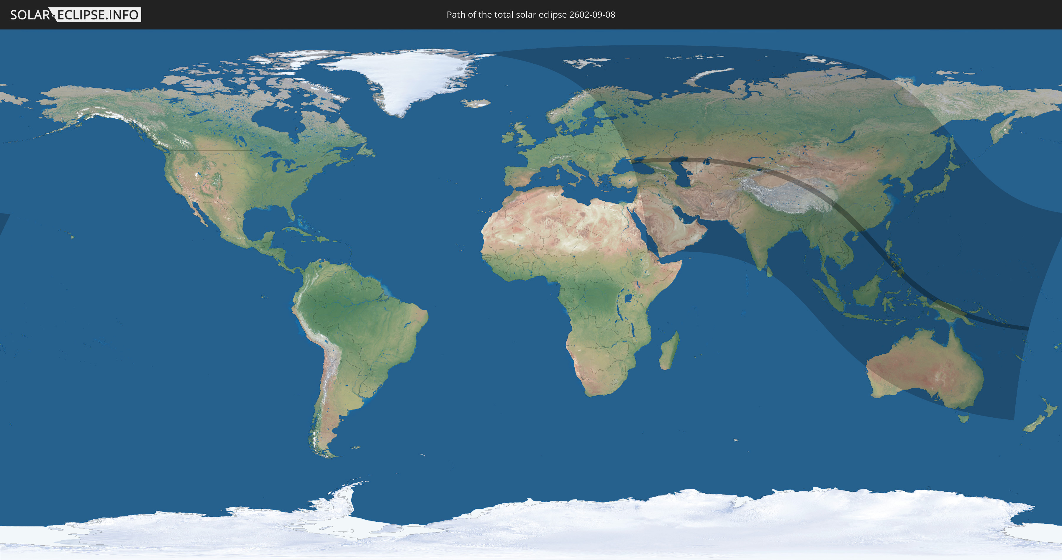
Total solar eclipse of 09/08/2602
| Day of week: | Wednesday |
| Maximum duration of eclipse: | 04m39s |
| Maximum width of eclipse path: | 196 km |
| Saros cycle: | 154 |
| Coverage: | 100% |
| Magnitude: | 1.0572 |
| Gamma: | 0.2895 |
Wo kann man die Sonnenfinsternis vom 09/08/2602 sehen?
Die Sonnenfinsternis am 09/08/2602 kann man in 71 Ländern als partielle Sonnenfinsternis beobachten.
Der Finsternispfad verläuft durch 11 Länder. Nur in diesen Ländern ist sie als total Sonnenfinsternis zu sehen.
In den folgenden Ländern ist die Sonnenfinsternis total zu sehen
 Russia
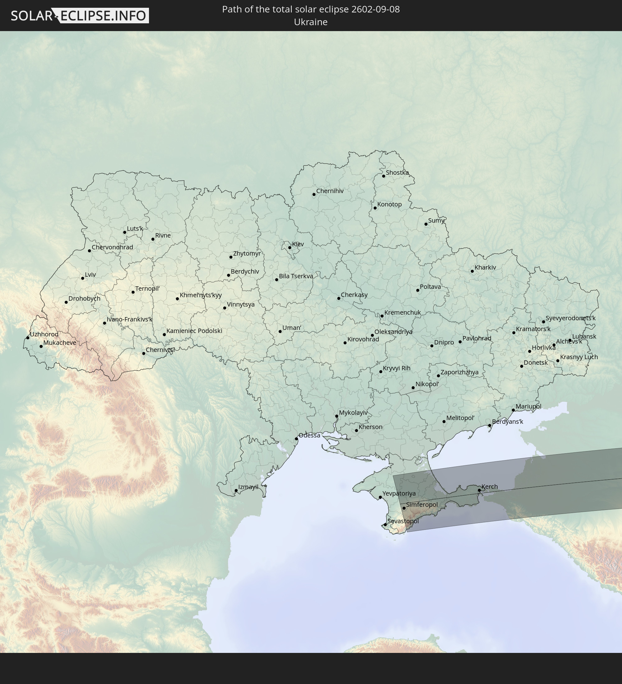 Ukraine
 Kazakhstan
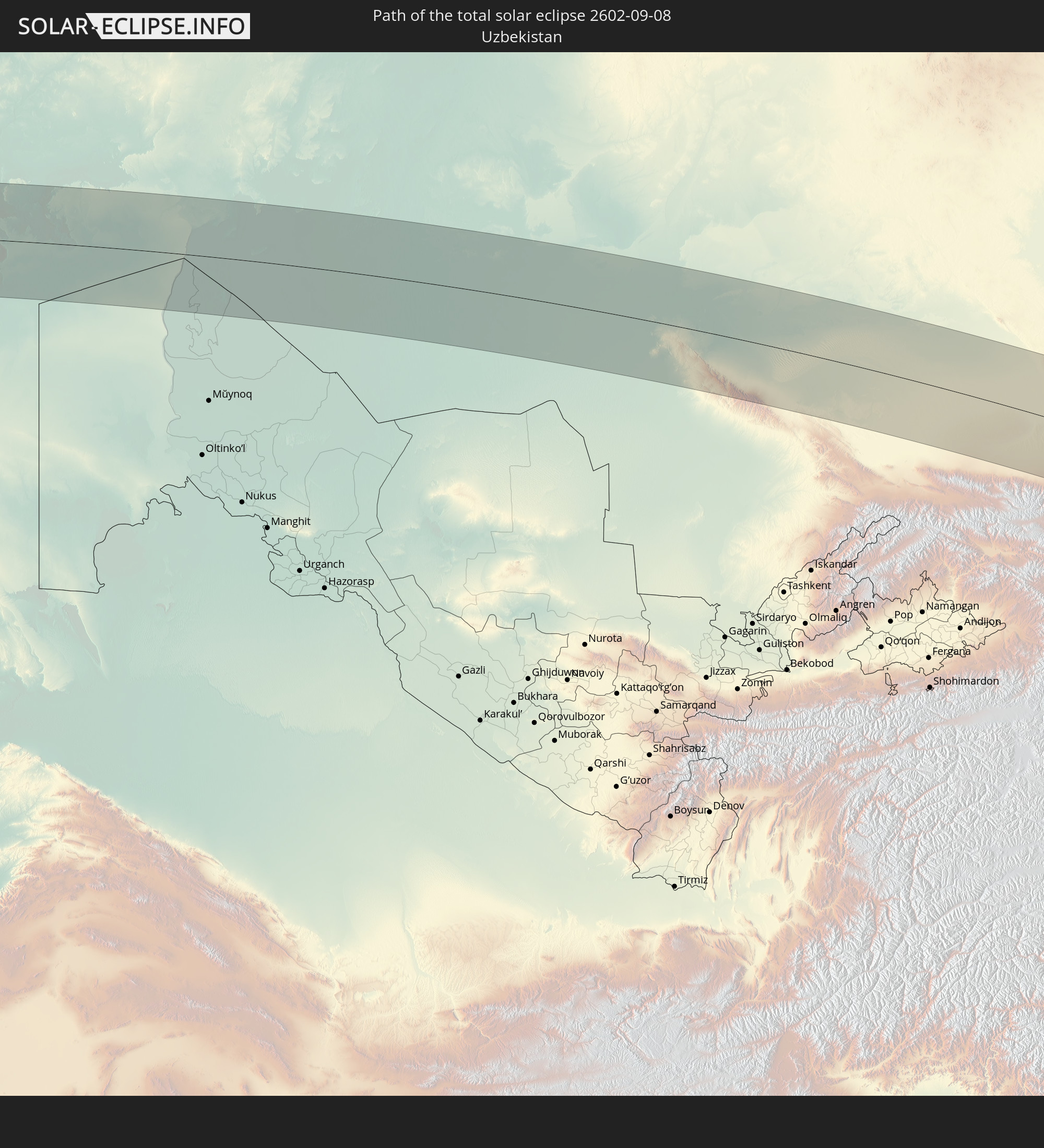 Uzbekistan
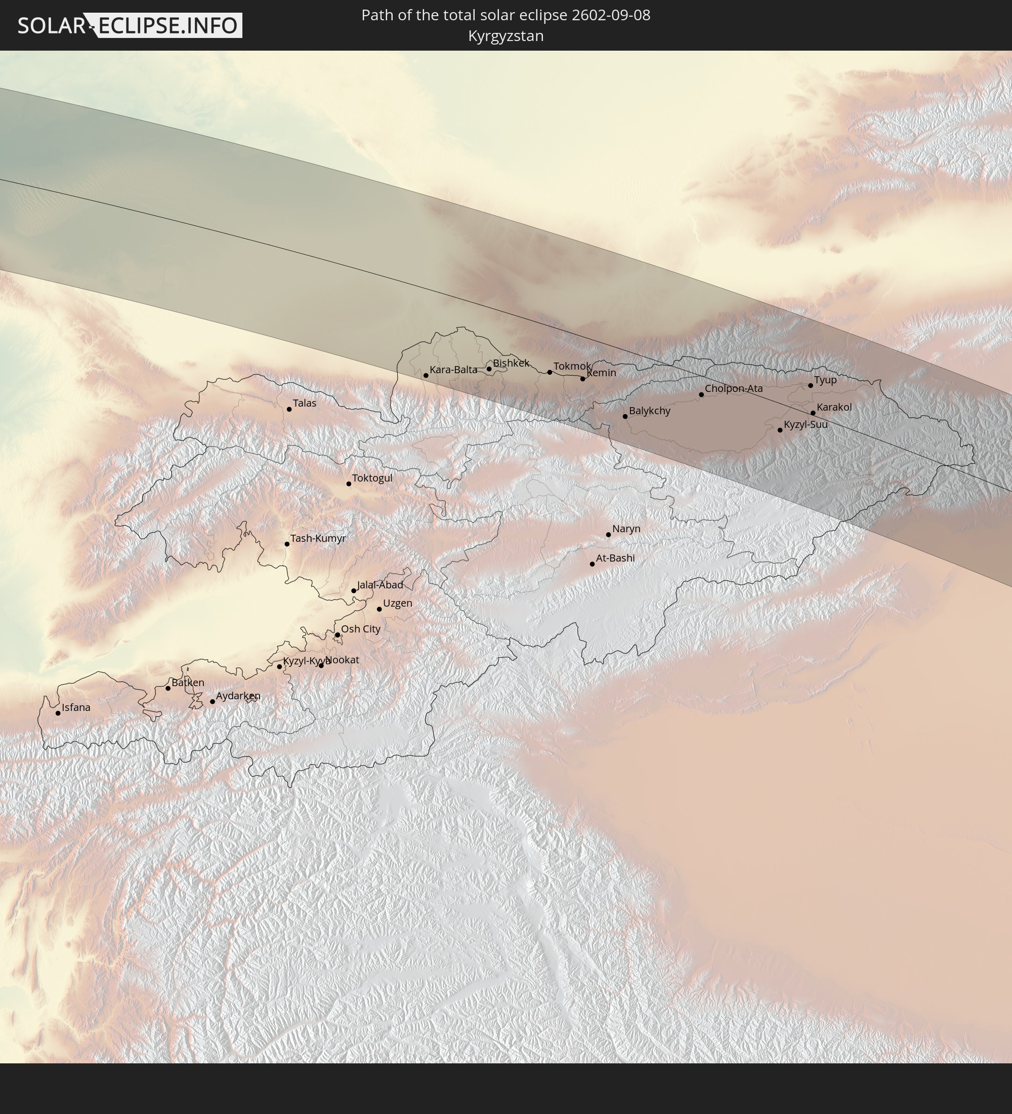 Kyrgyzstan
 China
China
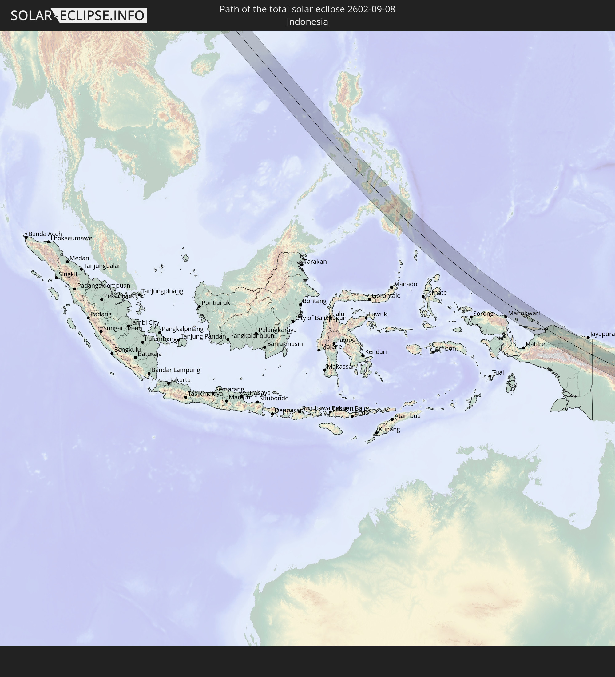 Indonesia
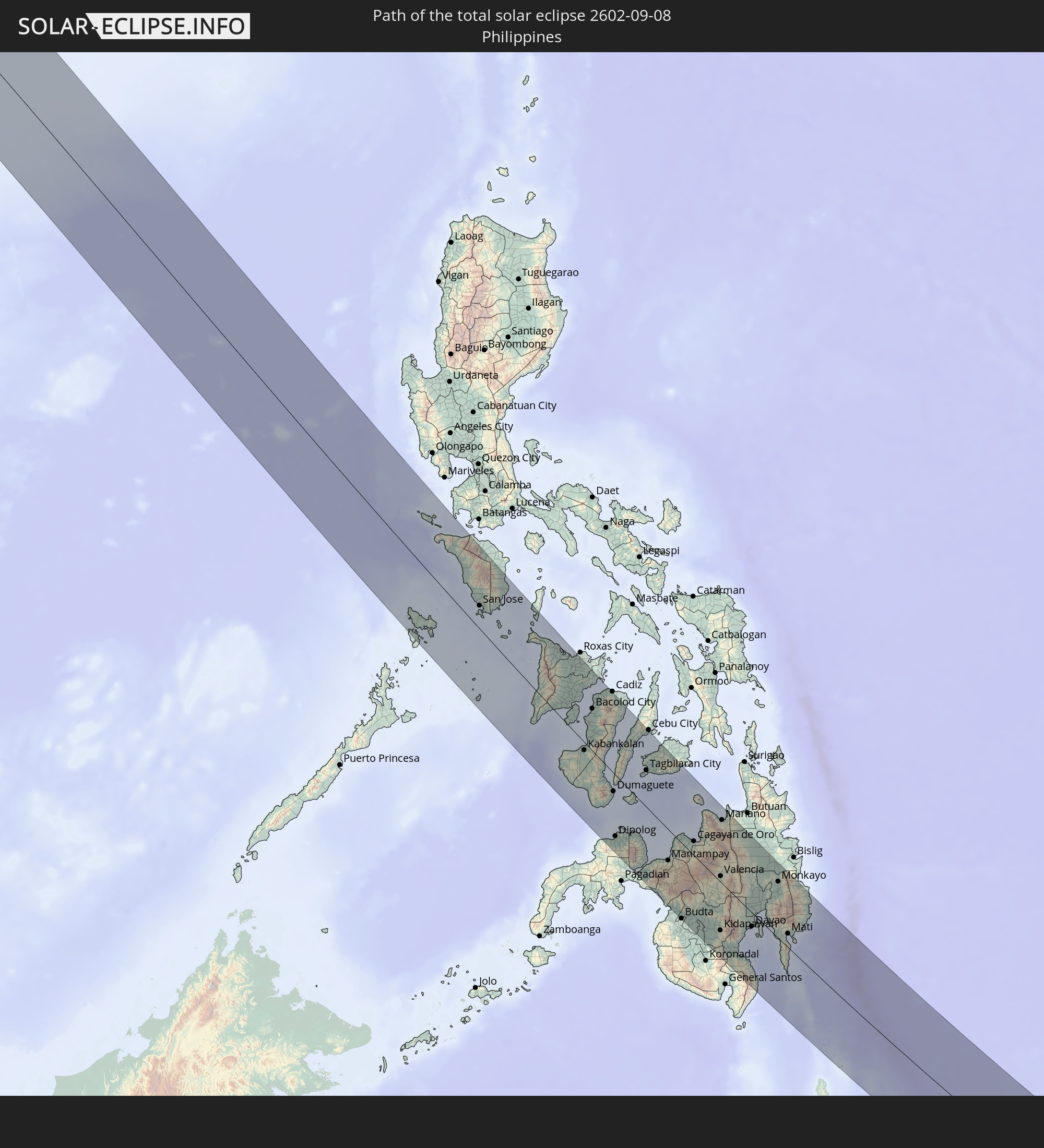 Philippines
 Palau
Palau
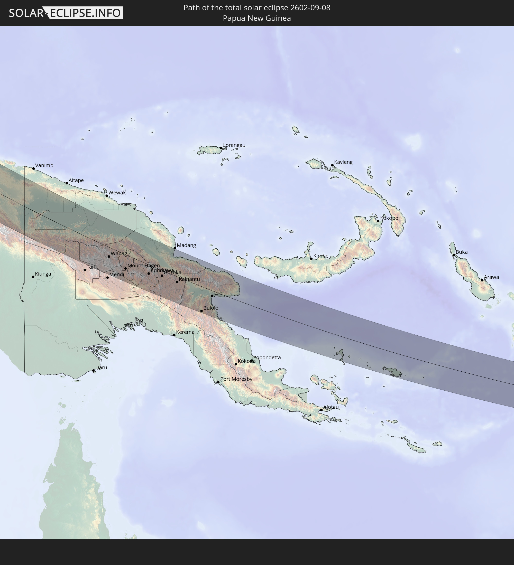 Papua New Guinea
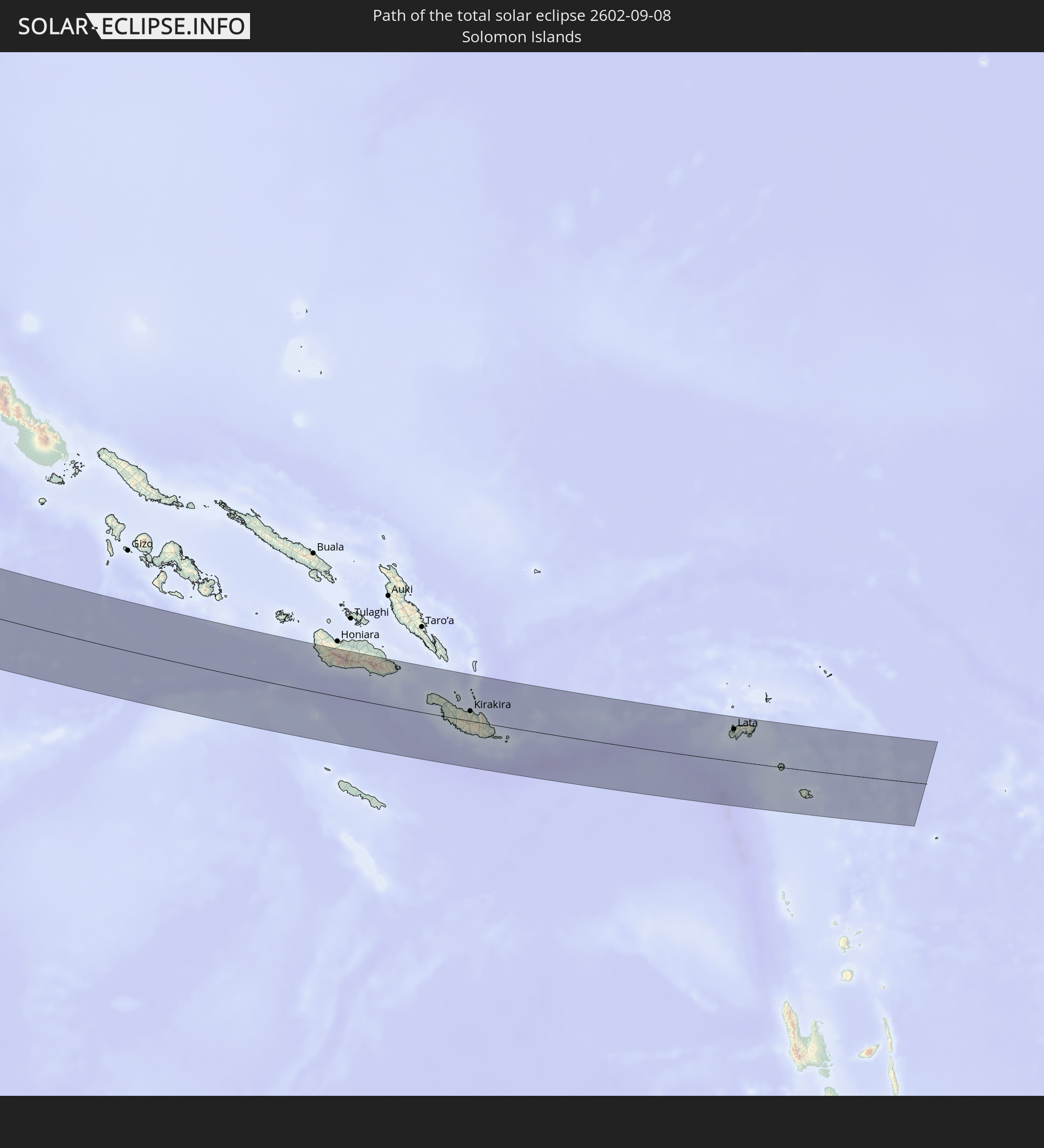 Solomon Islands
In den folgenden Ländern ist die Sonnenfinsternis partiell zu sehen
 Russia
 United States Minor Outlying Islands
 Kiribati
 Greenland
 Svalbard and Jan Mayen
 Norway
 Sweden
 Finland
 Estonia
 Ukraine
 Belarus
 Turkey
 Ethiopia
 Saudi Arabia
 Jordan
 Syria
Syria
 Eritrea
 Iraq
Iraq
 Georgia
 Yemen
Yemen
 Armenia
 Iran
Iran
 Azerbaijan
 Kazakhstan
 Kuwait
 Bahrain
 Qatar
Qatar
 United Arab Emirates
 Oman
Oman
 Turkmenistan
 Uzbekistan
 Afghanistan
 Pakistan
 Tajikistan
 India
India
 Kyrgyzstan
 China
China
 Sri Lanka
 Nepal
Nepal
 Mongolia
 Bangladesh
 Bhutan
 Myanmar
 Indonesia
 Thailand
 Malaysia
 Laos
Laos
 Vietnam
 Cambodia
 Singapore
 Christmas Island
 Australia
 Macau
Macau
 Hong Kong
 Brunei
 Taiwan
 Philippines
 Japan
Japan
 East Timor
 North Korea
 South Korea
 Palau
Palau
 Federated States of Micronesia
 Papua New Guinea
 Guam
Guam
 Northern Mariana Islands
 Solomon Islands
 New Caledonia
 Marshall Islands
 Vanuatu
 Nauru
Nauru
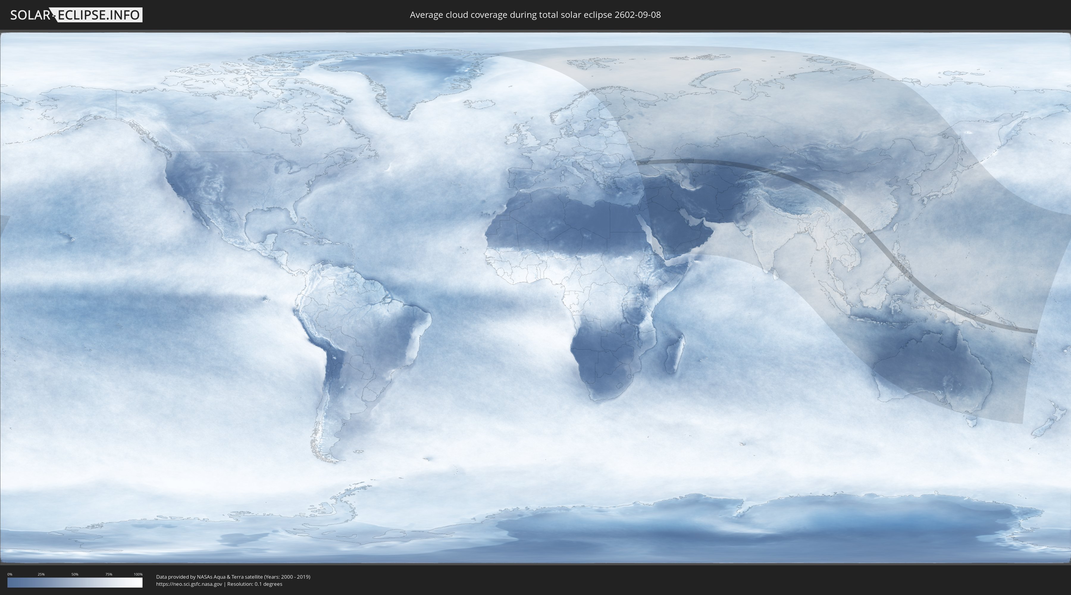
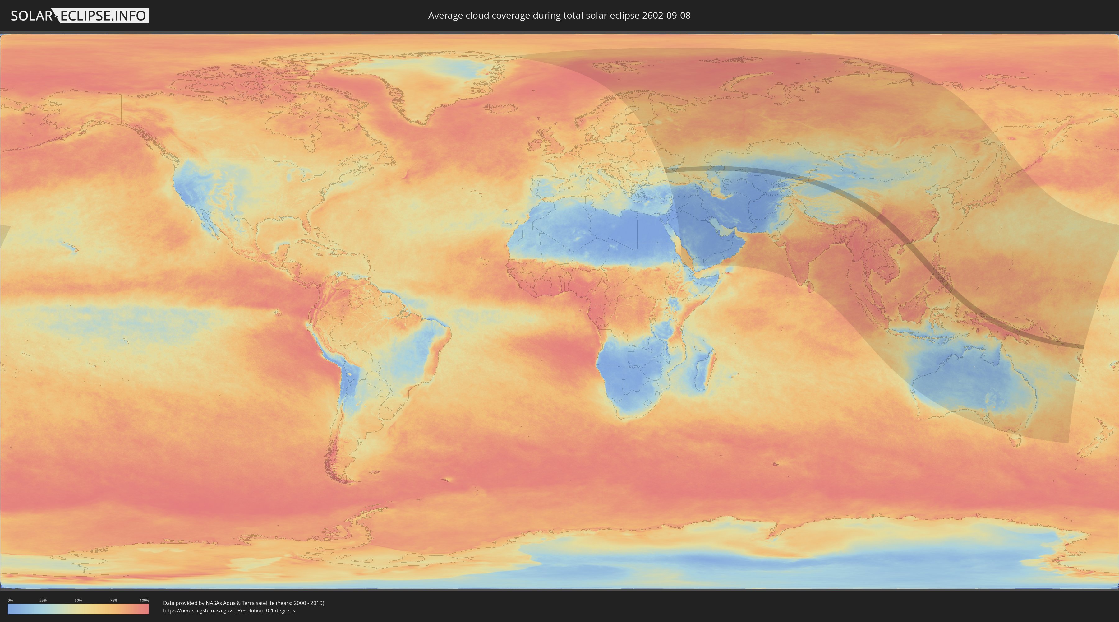
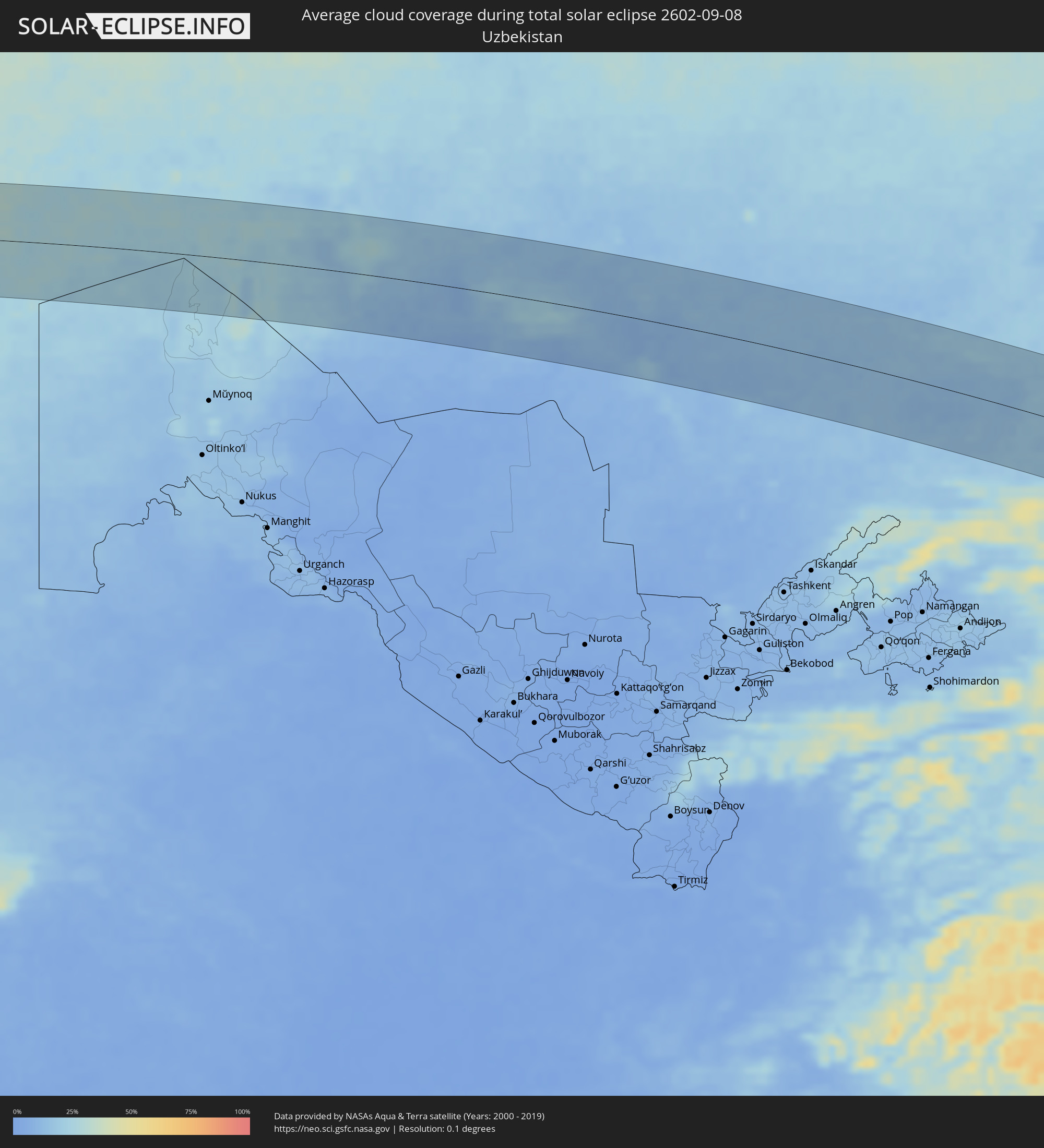
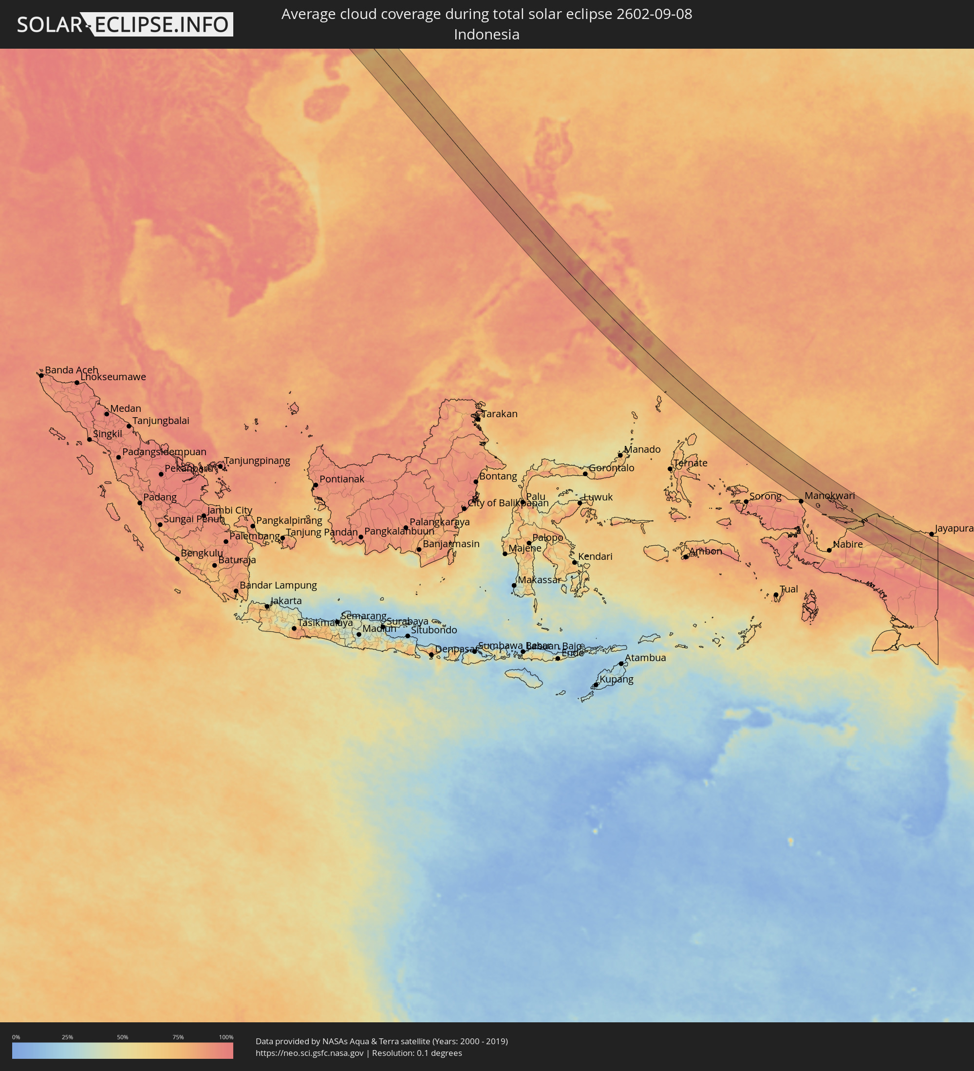
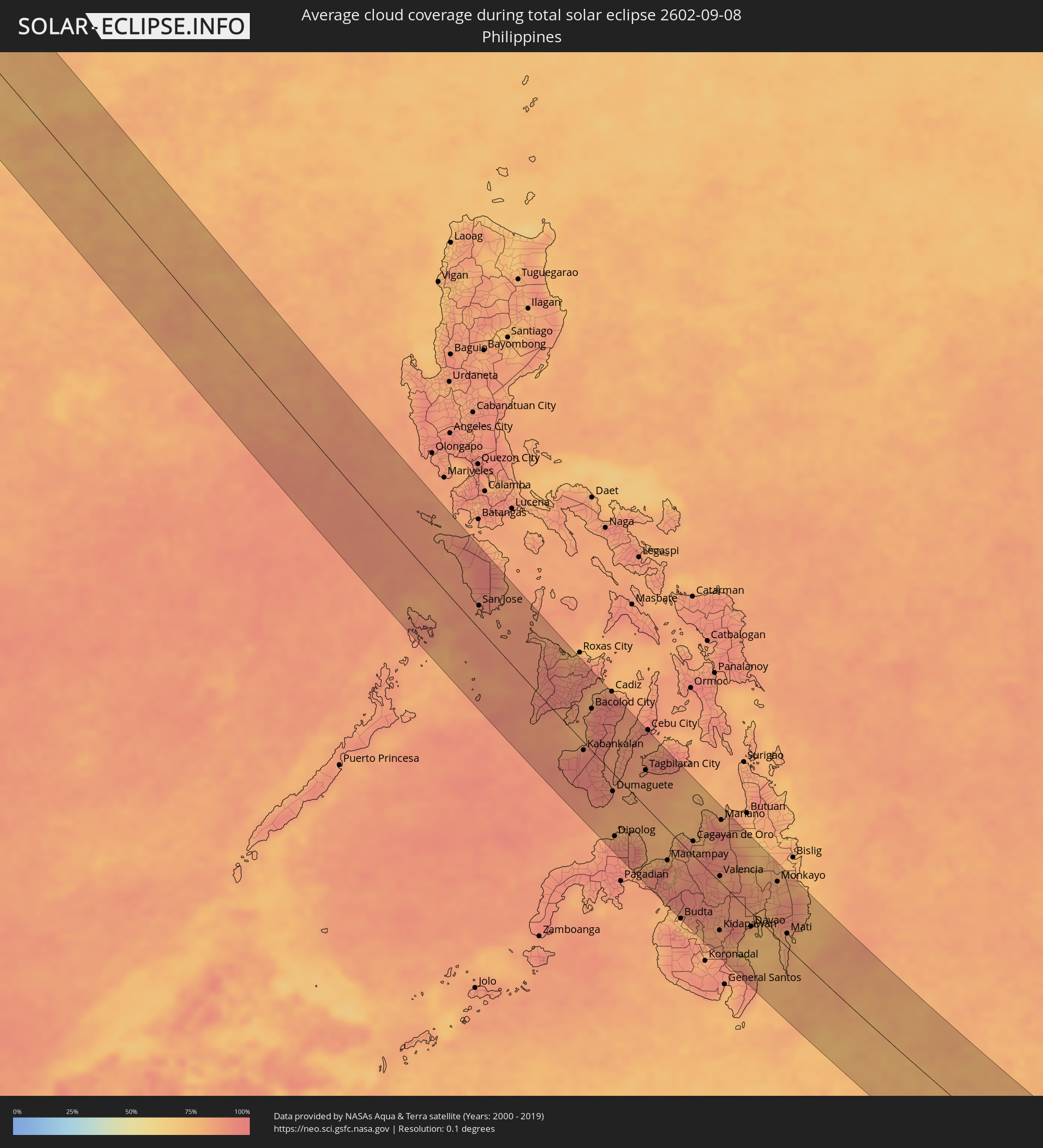
How will be the weather during the total solar eclipse on 09/08/2602?
Where is the best place to see the total solar eclipse of 09/08/2602?
The following maps show the average cloud coverage for the day of the total solar eclipse.
With the help of these maps, it is possible to find the place along the eclipse path, which has the best
chance of a cloudless sky.
Nevertheless, you should consider local circumstances and inform about the weather of your chosen
observation site.
The data is provided by NASAs satellites
AQUA and TERRA.
The cloud maps are averaged over a period of 19 years (2000 - 2019).
Detailed country maps
 Russia
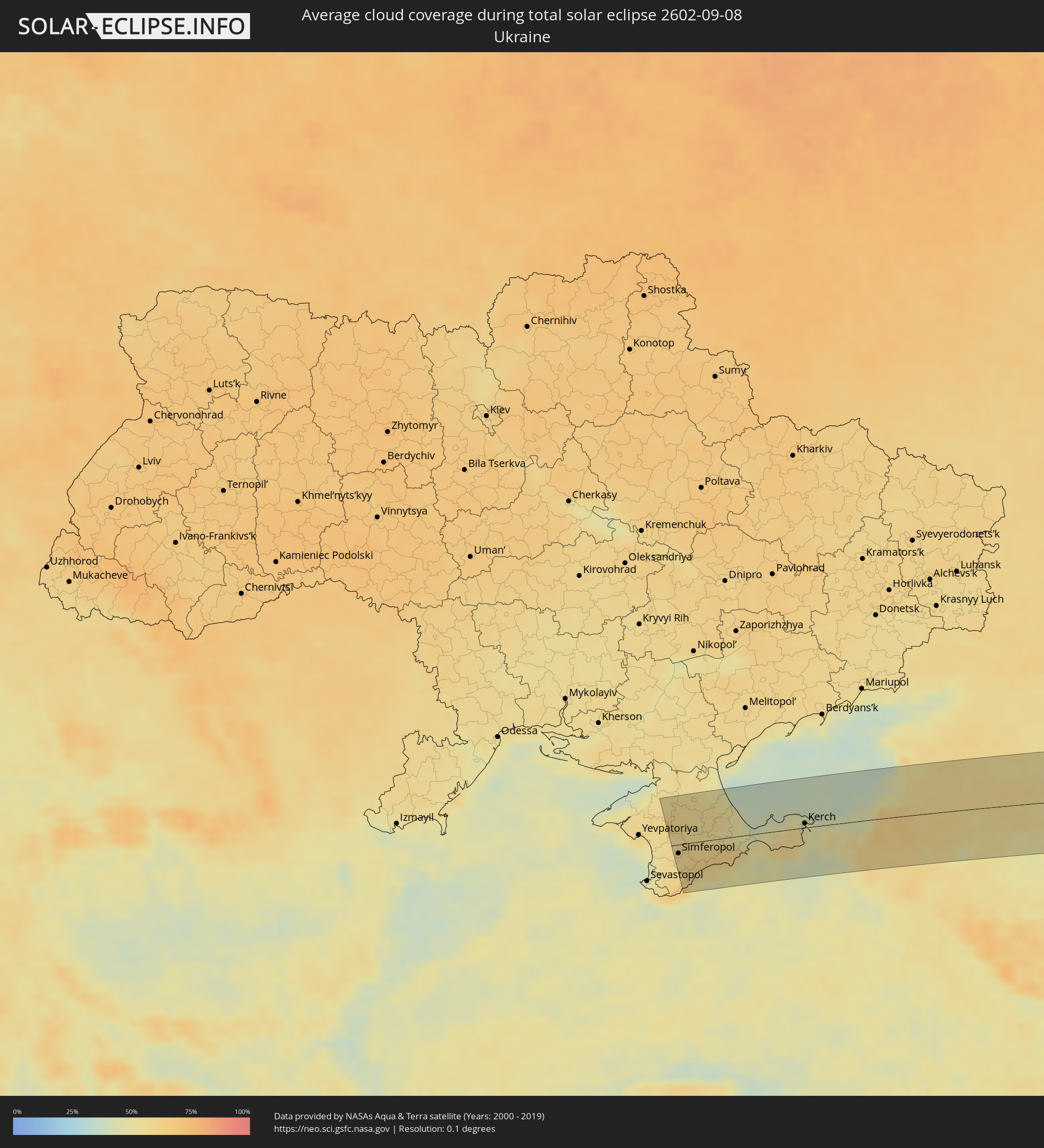 Ukraine
 Kazakhstan
 Uzbekistan
 Kyrgyzstan
 China
China
 Indonesia
 Philippines
 Palau
Palau
 Papua New Guinea
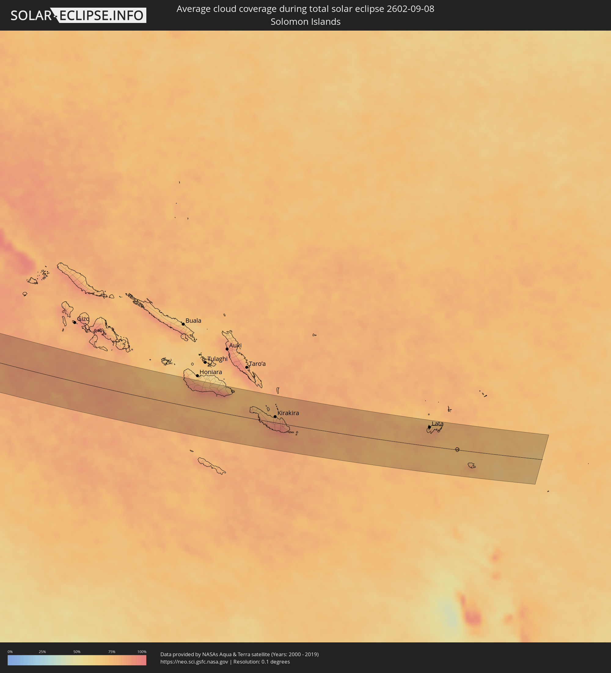 Solomon Islands
Cities inside the path of the eclipse
The following table shows all locations with a population of more than 5,000 inside the eclipse path. Cities which have more than 100,000 inhabitants are marked bold. A click at the locations opens a detailed map.
| City | Type | Eclipse duration | Local time of max. eclipse | Distance to central line | Ø Cloud coverage |
|
Gvardeyskoye, Republic of Crimea
|
total | - | 06:19:33 UTC+03:00 | 6 km | 57% |
|
Gresovskiy, Republic of Crimea
|
total | - | 06:19:29 UTC+03:00 | 6 km | 58% |
|
Molodyozhnoye, Republic of Crimea
|
total | - | 06:19:29 UTC+03:00 | 8 km | 59% |
|
Mirnoye, Republic of Crimea
|
total | - | 06:19:28 UTC+03:00 | 10 km | 59% |
|
Simferopol, Republic of Crimea
|
total | - | 06:19:27 UTC+03:00 | 15 km | 59% |
|
Oktyabr’skoye, Republic of Crimea
|
total | - | 06:19:39 UTC+03:00 | 27 km | 57% |
|
Massandra, Republic of Crimea
|
total | - | 06:19:11 UTC+03:00 | 63 km | 54% |
|
Gurzuf, Republic of Crimea
|
total | - | 06:19:12 UTC+03:00 | 62 km | 49% |
|
Petrovka, Republic of Crimea
|
total | - | 06:19:46 UTC+03:00 | 45 km | 56% |
|
Krasnogvardeyskoye, Republic of Crimea
|
total | - | 06:19:46 UTC+03:00 | 45 km | 56% |
|
Dzhankoy, Republic of Crimea
|
total | - | 06:19:53 UTC+03:00 | 67 km | 56% |
|
Alushta, Republic of Crimea
|
total | - | 06:19:16 UTC+03:00 | 47 km | 55% |
|
Belogorsk, Republic of Crimea
|
total | - | 06:19:29 UTC+03:00 | 7 km | 60% |
|
Nizhnegorskiy, Republic of Crimea
|
total | - | 06:19:42 UTC+03:00 | 34 km | 55% |
|
Sovetskiy, Republic of Crimea
|
total | - | 06:19:38 UTC+03:00 | 21 km | 52% |
|
Sudak, Republic of Crimea
|
total | - | 06:19:20 UTC+03:00 | 34 km | 52% |
|
Stary Krym, Republic of Crimea
|
total | - | 06:19:27 UTC+03:00 | 16 km | 62% |
|
Kirovskoye, Republic of Crimea
|
total | - | 06:19:33 UTC+03:00 | 5 km | 56% |
|
Feodosiya, Republic of Crimea
|
total | - | 06:19:26 UTC+03:00 | 18 km | 51% |
|
Primorskiy, Republic of Crimea
|
total | - | 06:19:29 UTC+03:00 | 10 km | 50% |
|
Lenino, Republic of Crimea
|
total | - | 06:19:35 UTC+03:00 | 7 km | 50% |
|
Shchyolkino, Republic of Crimea
|
total | - | 06:19:40 UTC+03:00 | 21 km | 48% |
|
Kerch, Republic of Crimea
|
total | - | 06:19:36 UTC+03:00 | 6 km | 52% |
|
Anapa, Krasnodarskiy
|
total | - | 06:19:20 UTC+03:00 | 53 km | 48% |
|
Temryuk, Krasnodarskiy
|
total | - | 06:19:33 UTC+03:00 | 11 km | 55% |
|
Krymsk, Krasnodarskiy
|
total | - | 06:19:22 UTC+03:00 | 55 km | 56% |
|
Slavyansk-na-Kubani, Krasnodarskiy
|
total | - | 06:19:33 UTC+03:00 | 20 km | 60% |
|
Primorsko-Akhtarsk, Krasnodarskiy
|
total | - | 06:20:02 UTC+03:00 | 68 km | 48% |
|
Timashëvsk, Krasnodarskiy
|
total | - | 06:19:48 UTC+03:00 | 14 km | 58% |
|
Kanevskaya, Krasnodarskiy
|
total | - | 06:20:05 UTC+03:00 | 65 km | 56% |
|
Krasnodar, Krasnodarskiy
|
total | - | 06:19:28 UTC+03:00 | 50 km | 56% |
|
Dinskaya, Krasnodarskiy
|
total | - | 06:19:34 UTC+03:00 | 33 km | 56% |
|
Korenovsk, Krasnodarskiy
|
total | - | 06:19:44 UTC+03:00 | 7 km | 55% |
|
Ust’-Labinsk, Krasnodarskiy
|
total | - | 06:19:36 UTC+03:00 | 37 km | 51% |
|
Pavlovskaya, Krasnodarskiy
|
total | - | 06:20:10 UTC+03:00 | 65 km | 55% |
|
Tikhoretsk, Krasnodarskiy
|
total | - | 06:20:01 UTC+03:00 | 31 km | 59% |
|
Kropotkin, Krasnodarskiy
|
total | - | 06:19:47 UTC+03:00 | 18 km | 54% |
|
Novokubansk, Krasnodarskiy
|
total | - | 06:19:38 UTC+03:00 | 57 km | 50% |
|
Armavir, Krasnodarskiy
|
total | - | 06:19:34 UTC+03:00 | 72 km | 49% |
|
Izobil’nyy, Stavropol'skiy
|
total | - | 06:19:51 UTC+03:00 | 33 km | 58% |
|
Stavropol’, Stavropol'skiy
|
total | - | 06:19:41 UTC+03:00 | 71 km | 55% |
|
Svetlograd, Stavropol'skiy
|
total | - | 06:19:58 UTC+03:00 | 44 km | 56% |
|
Ipatovo, Stavropol'skiy
|
total | - | 06:20:12 UTC+03:00 | 1 km | 55% |
|
Blagodarnyy, Stavropol'skiy
|
total | - | 06:19:54 UTC+03:00 | 73 km | 53% |
|
Elista, Kalmykiya
|
total | - | 06:20:44 UTC+03:00 | 58 km | 51% |
|
Astrakhan, Astrakhan
|
total | - | 07:21:31 UTC+04:00 | 52 km | 41% |
|
Qaraton, Atyraū
|
total | - | 08:23:12 UTC+05:00 | 65 km | 34% |
|
Beyneu, Mangghystaū
|
total | - | 08:23:18 UTC+05:00 | 53 km | 23% |
|
Ayteke Bi, Qyzylorda
|
total | - | 08:27:00 UTC+05:00 | 57 km | 24% |
|
Tyuratam, Baikonur
|
total | - | 08:27:37 UTC+05:00 | 48 km | 14% |
|
Baikonur, Baikonur
|
total | - | 08:27:36 UTC+05:00 | 45 km | 13% |
|
Zhosaly, Qyzylorda
|
total | - | 08:28:02 UTC+05:00 | 40 km | 16% |
|
Dzhalagash, Qyzylorda
|
total | - | 08:28:16 UTC+05:00 | 3 km | 20% |
|
Terenozek, Qyzylorda
|
total | - | 08:28:28 UTC+05:00 | 3 km | 22% |
|
Kyzylorda, Qyzylorda
|
total | - | 08:28:45 UTC+05:00 | 11 km | 18% |
|
Tasböget, Qyzylorda
|
total | - | 08:28:46 UTC+05:00 | 20 km | 16% |
|
Shīeli, Qyzylorda
|
total | - | 08:29:25 UTC+05:00 | 68 km | 16% |
|
Chulakkurgan, Ongtüstik Qazaqstan
|
total | - | 08:31:10 UTC+05:00 | 72 km | 11% |
|
Moyynkum, Zhambyl
|
total | - | 08:34:23 UTC+05:00 | 57 km | 18% |
|
Oytal, Zhambyl
|
total | - | 08:34:33 UTC+05:00 | 83 km | 19% |
|
Kaindy, Chüy
|
total | - | 09:34:55 UTC+06:00 | 83 km | 24% |
|
Chu, Zhambyl
|
total | - | 08:35:02 UTC+05:00 | 2 km | 18% |
|
Kara-Balta, Chüy
|
total | - | 09:35:04 UTC+06:00 | 80 km | 24% |
|
Bishkek, Bishkek
|
total | - | 09:35:46 UTC+06:00 | 57 km | 23% |
|
Georgiyevka, Zhambyl
|
total | - | 08:35:53 UTC+05:00 | 36 km | 20% |
|
Kant, Chüy
|
total | - | 09:36:01 UTC+06:00 | 48 km | 24% |
|
Tokmok, Chüy
|
total | - | 09:36:27 UTC+06:00 | 42 km | 28% |
|
Kemin, Chüy
|
total | - | 09:36:49 UTC+06:00 | 39 km | 27% |
|
Balykchy, Issyk-Kul Region
|
total | - | 09:37:19 UTC+06:00 | 61 km | 24% |
|
Burunday, Almaty Oblysy
|
total | - | 08:37:57 UTC+05:00 | 52 km | 27% |
|
Almaty, Almaty Qalasy
|
total | - | 08:38:01 UTC+05:00 | 43 km | 29% |
|
Otegen Batyra, Almaty Oblysy
|
total | - | 08:38:06 UTC+05:00 | 62 km | 27% |
|
Cholpon-Ata, Issyk-Kul Region
|
total | - | 09:38:12 UTC+06:00 | 17 km | 17% |
|
Talghar, Almaty Oblysy
|
total | - | 08:38:20 UTC+05:00 | 56 km | 35% |
|
Esik, Almaty Oblysy
|
total | - | 08:38:32 UTC+05:00 | 67 km | 34% |
|
Turgen, Almaty Oblysy
|
total | - | 08:38:40 UTC+05:00 | 75 km | 35% |
|
Kyzyl-Suu, Issyk-Kul Region
|
total | - | 09:39:10 UTC+06:00 | 25 km | 34% |
|
Tyup, Issyk-Kul Region
|
total | - | 09:39:30 UTC+06:00 | 26 km | 27% |
|
Karakol, Issyk-Kul Region
|
total | - | 09:39:33 UTC+06:00 | 2 km | 33% |
|
Ak-Suu, Issyk-Kul Region
|
total | - | 09:39:41 UTC+06:00 | 6 km | 36% |
|
Kegen, Almaty Oblysy
|
total | - | 08:40:21 UTC+05:00 | 81 km | 37% |
|
Aksu, Xinjiang Uyghur Autonomous Region
|
total | - | 11:41:47 UTC+08:00 | 79 km | 36% |
|
Leshan, Sichuan
|
total | - | 12:26:35 UTC+08:00 | 17 km | 90% |
|
Chengdu, Sichuan
|
total | - | 12:25:24 UTC+08:00 | 93 km | 88% |
|
Yibin, Sichuan
|
total | - | 12:29:18 UTC+08:00 | 23 km | 89% |
|
Yanjiang, Sichuan
|
total | - | 12:27:13 UTC+08:00 | 87 km | 86% |
|
Zigong, Sichuan
|
total | - | 12:28:38 UTC+08:00 | 33 km | 87% |
|
Neijiang, Sichuan
|
total | - | 12:28:45 UTC+08:00 | 72 km | 88% |
|
Guiyang, Guizhou
|
total | - | 12:36:33 UTC+08:00 | 49 km | 85% |
|
Loushanguan, Guizhou
|
total | - | 12:34:05 UTC+08:00 | 79 km | 88% |
|
Zunyi, Guizhou
|
total | - | 12:34:59 UTC+08:00 | 50 km | 88% |
|
Duyun, Guizhou
|
total | - | 12:38:30 UTC+08:00 | 16 km | 88% |
|
Yulin, Guangxi Zhuang Autonomous Region
|
total | - | 12:49:49 UTC+08:00 | 95 km | 89% |
|
Yangshuo, Guangxi Zhuang Autonomous Region
|
total | - | 12:46:20 UTC+08:00 | 90 km | 89% |
|
Gaozhou, Guangdong
|
total | - | 12:52:23 UTC+08:00 | 93 km | 90% |
|
Xinyi, Guangdong
|
total | - | 12:51:43 UTC+08:00 | 53 km | 85% |
|
Wuzhou, Guangxi Zhuang Autonomous Region
|
total | - | 12:50:13 UTC+08:00 | 57 km | 89% |
|
Ducheng, Guangdong
|
total | - | 12:51:03 UTC+08:00 | 56 km | 88% |
|
Yangchun, Guangdong
|
total | - | 12:53:35 UTC+08:00 | 4 km | 87% |
|
Tangping, Guangdong
|
total | - | 12:54:06 UTC+08:00 | 2 km | 88% |
|
Yangjiang, Guangdong
|
total | - | 12:54:30 UTC+08:00 | 13 km | 86% |
|
Yunfu, Guangdong
|
total | - | 12:52:32 UTC+08:00 | 72 km | 91% |
|
Encheng, Guangdong
|
total | - | 12:54:26 UTC+08:00 | 38 km | 88% |
|
Taishan, Guangdong
|
total | - | 12:55:08 UTC+08:00 | 80 km | 89% |
|
San Jose, Mimaropa
|
total | - | 13:29:13 UTC+08:00 | 28 km | 87% |
|
Iloilo, Western Visayas
|
total | - | 13:34:56 UTC+08:00 | 24 km | 85% |
|
Kabankalan, Western Visayas
|
total | - | 13:36:45 UTC+08:00 | 10 km | 93% |
|
Bago City, Western Visayas
|
total | - | 13:35:40 UTC+08:00 | 33 km | 82% |
|
Bacolod City, Western Visayas
|
total | - | 13:35:35 UTC+08:00 | 53 km | 93% |
|
Victorias, Western Visayas
|
total | - | 13:35:17 UTC+08:00 | 80 km | 91% |
|
Dumaguete, Central Visayas
|
total | - | 13:38:51 UTC+08:00 | 23 km | 86% |
|
Dipolog, Zamboanga Peninsula
|
total | - | 13:40:23 UTC+08:00 | 78 km | 82% |
|
Toledo, Central Visayas
|
total | - | 13:37:13 UTC+08:00 | 86 km | 85% |
|
Ozamiz City, Northern Mindanao
|
total | - | 13:41:58 UTC+08:00 | 71 km | 82% |
|
Talisay, Central Visayas
|
total | - | 13:37:48 UTC+08:00 | 92 km | 85% |
|
Tagbilaran City, Central Visayas
|
total | - | 13:38:59 UTC+08:00 | 47 km | 88% |
|
Mantampay, Northern Mindanao
|
total | - | 13:42:29 UTC+08:00 | 40 km | 81% |
|
Marawi City, Autonomous Region in Muslim Mindanao
|
total | - | 13:42:54 UTC+08:00 | 48 km | 83% |
|
Iligan City, Soccsksargen
|
total | - | 13:42:35 UTC+08:00 | 19 km | 81% |
|
Budta, Autonomous Region in Muslim Mindanao
|
total | - | 13:44:41 UTC+08:00 | 98 km | 74% |
|
Cagayan de Oro, Northern Mindanao
|
total | - | 13:42:29 UTC+08:00 | 18 km | 86% |
|
Valencia, Northern Mindanao
|
total | - | 13:44:16 UTC+08:00 | 8 km | 79% |
|
Digos, Davao
|
total | - | 13:46:54 UTC+08:00 | 64 km | 74% |
|
Davao, Davao
|
total | - | 13:46:38 UTC+08:00 | 18 km | 82% |
|
Panabo, Davao
|
total | - | 13:46:17 UTC+08:00 | 6 km | 77% |
|
Tagum, Davao
|
total | - | 13:46:11 UTC+08:00 | 27 km | 77% |
|
Mati, Davao
|
total | - | 13:47:43 UTC+08:00 | 18 km | 79% |
|
Tobi Village, Hatohobei
|
total | - | 15:01:26 UTC+09:00 | 46 km | 76% |
|
Wabag, Enga
|
total | - | 16:26:10 UTC+10:00 | 31 km | 84% |
|
Mount Hagen, Western Highlands
|
total | - | 16:26:58 UTC+10:00 | 45 km | 80% |
|
Minj, Jiwaka
|
total | - | 16:27:21 UTC+10:00 | 30 km | 80% |
|
Kundiawa, Chimbu
|
total | - | 16:27:40 UTC+10:00 | 29 km | 78% |
|
Goroka, Eastern Highlands
|
total | - | 16:28:01 UTC+10:00 | 18 km | 72% |
|
Kainantu, Eastern Highlands
|
total | - | 16:28:33 UTC+10:00 | 19 km | 83% |
|
Bulolo, Morobe
|
total | - | 16:30:02 UTC+10:00 | 81 km | 81% |
|
Lae, Morobe
|
total | - | 16:29:43 UTC+10:00 | 18 km | 81% |
|
Kirakira, Makira
|
total | - | 17:38:20 UTC+11:00 | 16 km | 88% |
|
Lata, Temotu
|
total | - | 17:38:48 UTC+11:00 | 52 km | 79% |