Total solar eclipse of 05/29/2682
| Day of week: | Monday |
| Maximum duration of eclipse: | 03m59s |
| Maximum width of eclipse path: | 132 km |
| Saros cycle: | 158 |
| Coverage: | 100% |
| Magnitude: | 1.039 |
| Gamma: | -0.1419 |
Wo kann man die Sonnenfinsternis vom 05/29/2682 sehen?
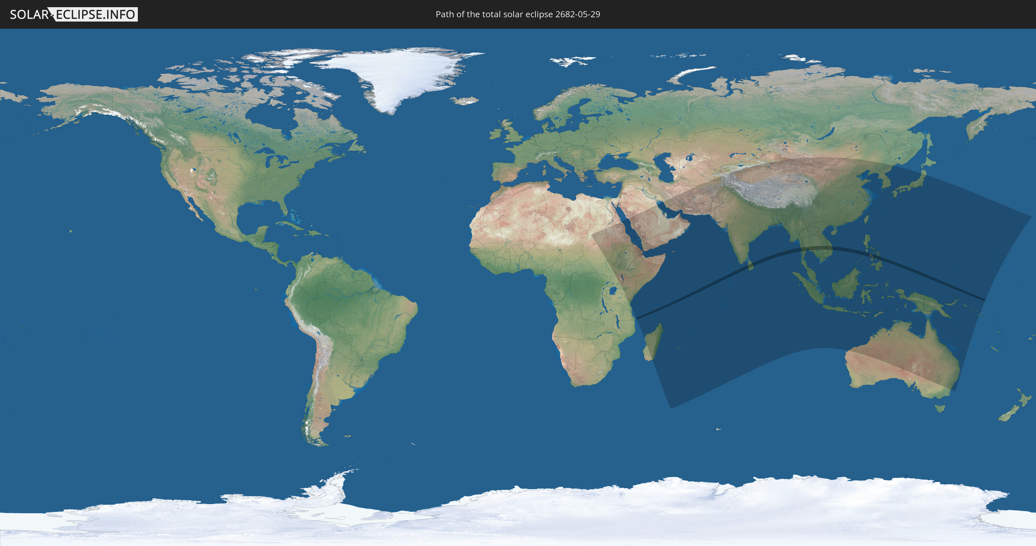
Die Sonnenfinsternis am 05/29/2682 kann man in 68 Ländern als partielle Sonnenfinsternis beobachten.
Der Finsternispfad verläuft durch 11 Länder. Nur in diesen Ländern ist sie als total Sonnenfinsternis zu sehen.
In den folgenden Ländern ist die Sonnenfinsternis total zu sehen
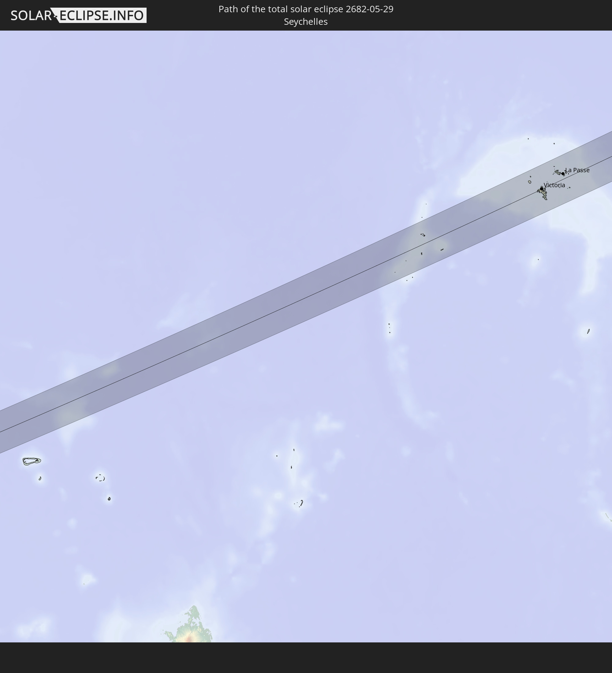 Seychelles
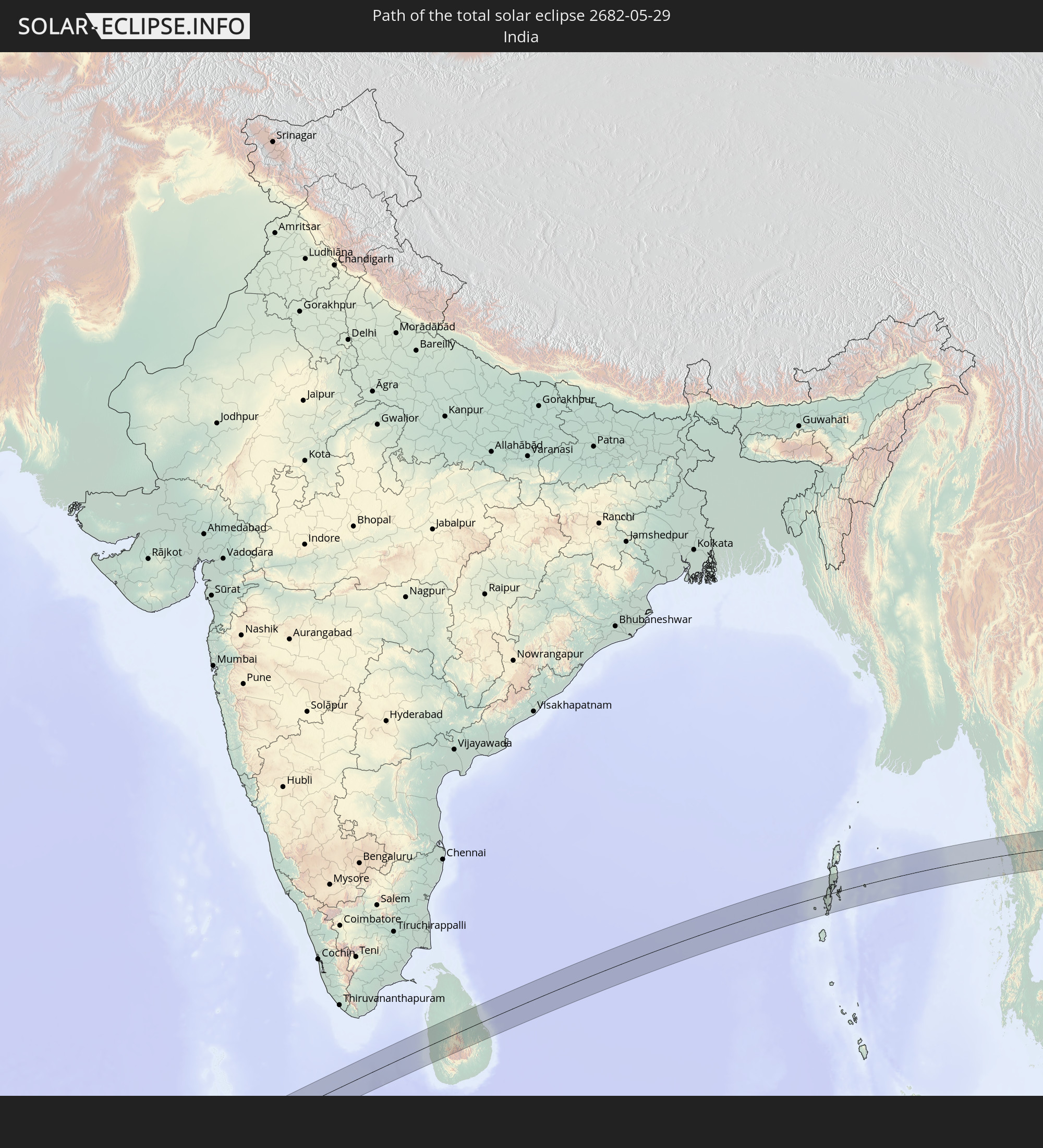 India
India
 Maldives
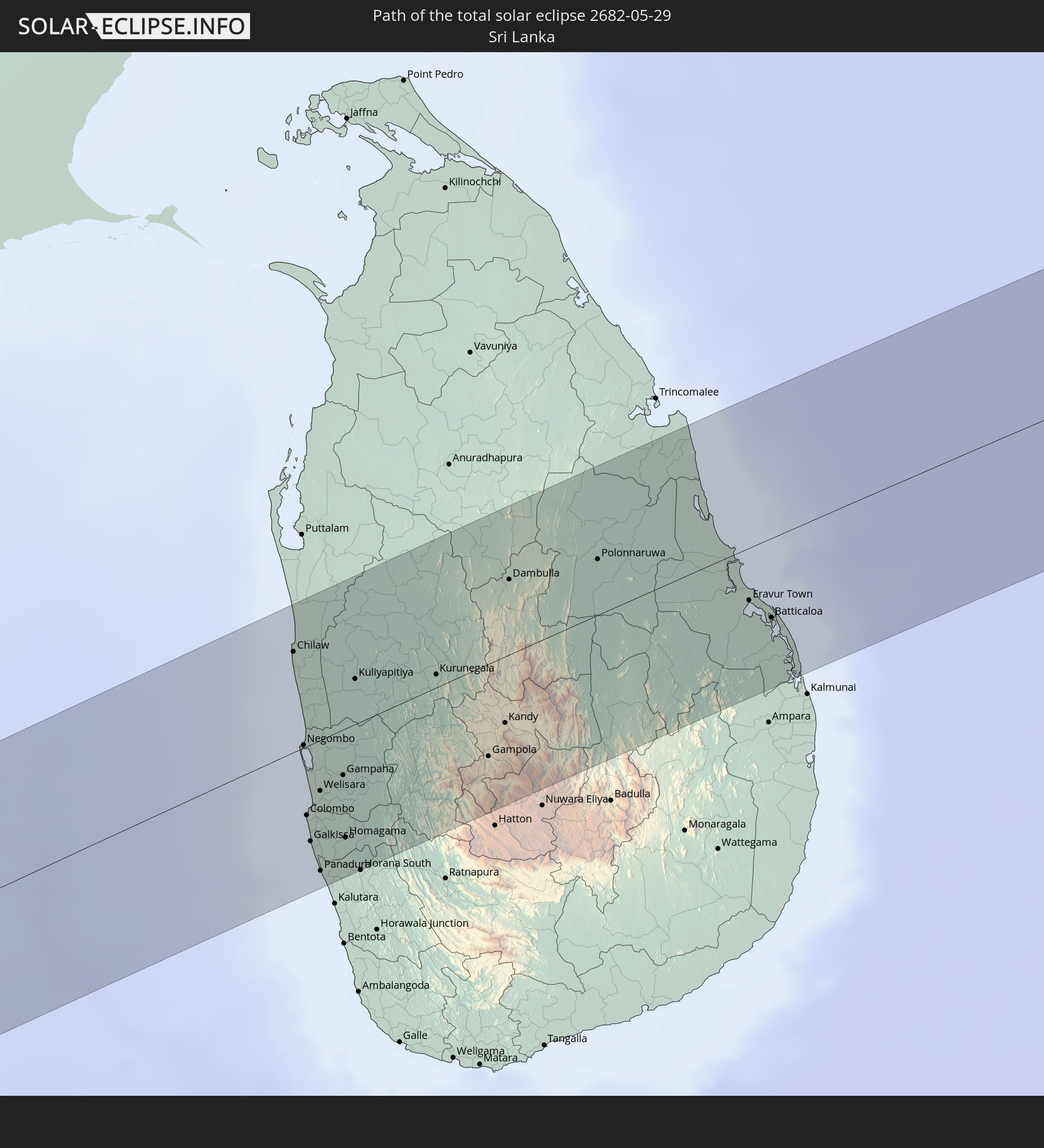 Sri Lanka
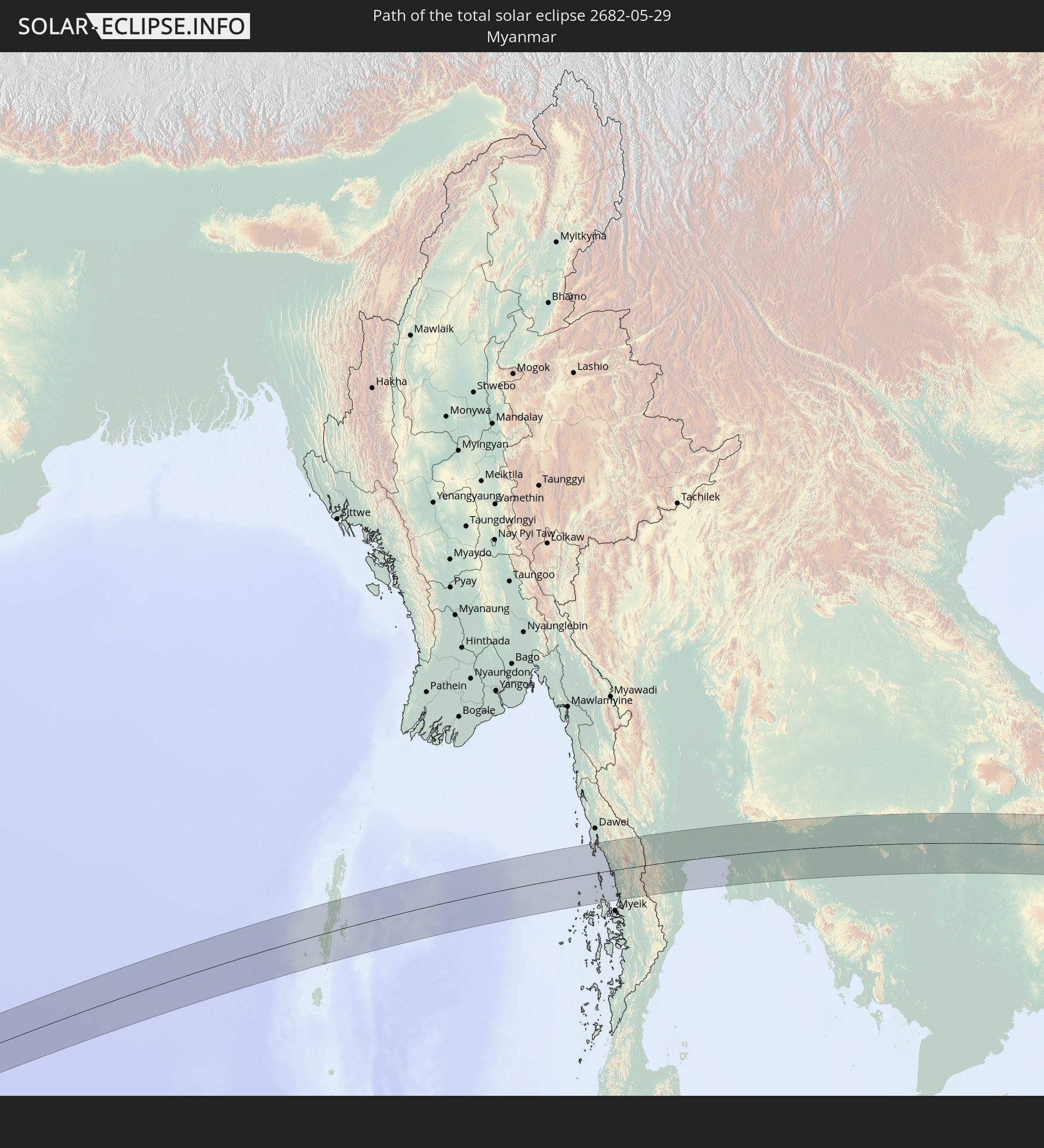 Myanmar
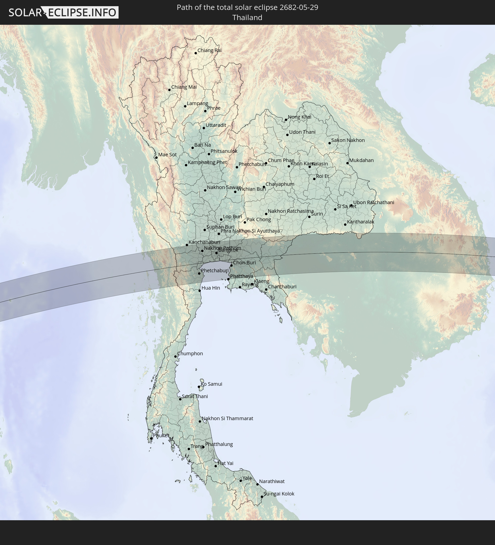 Thailand
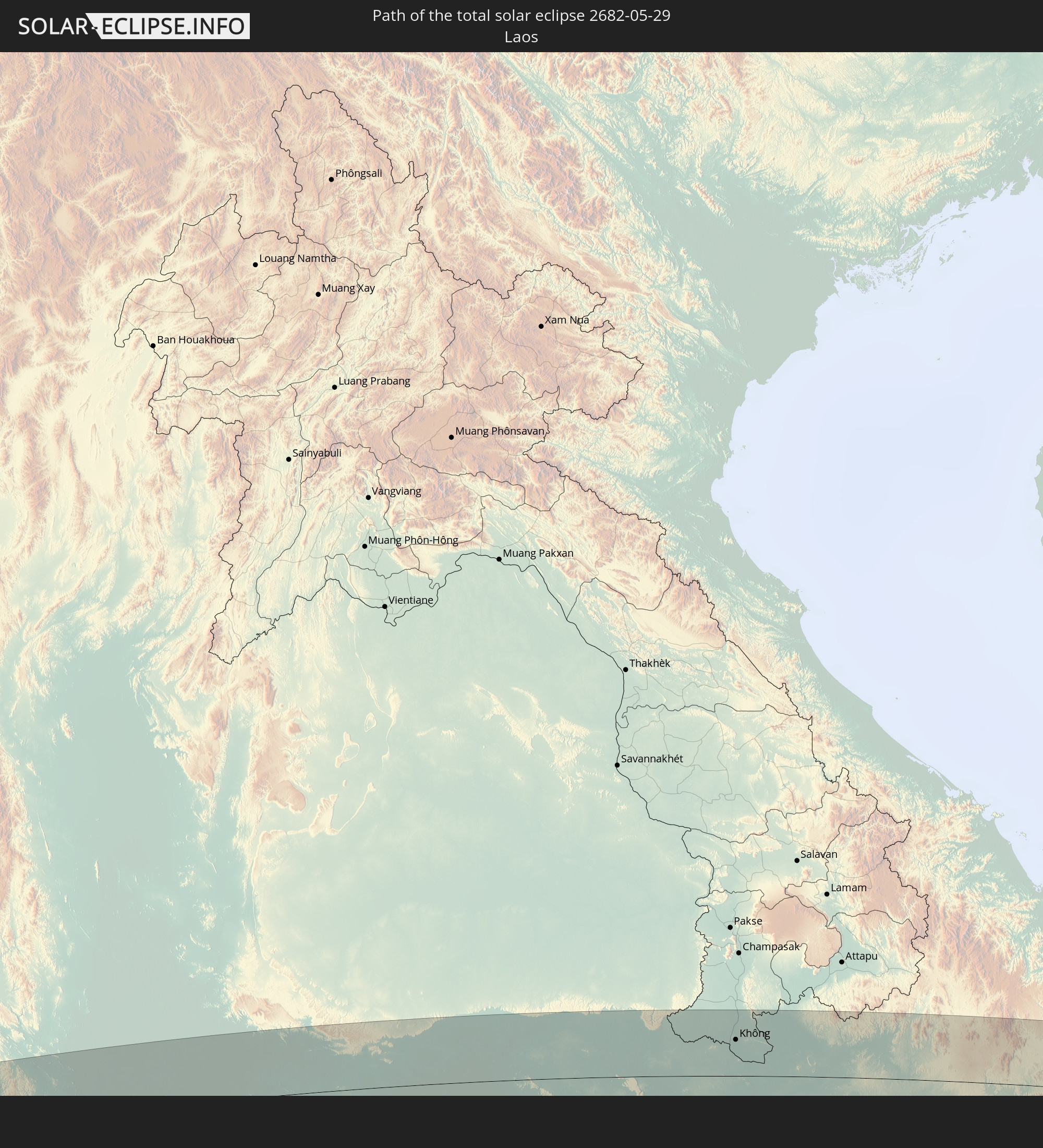 Laos
Laos
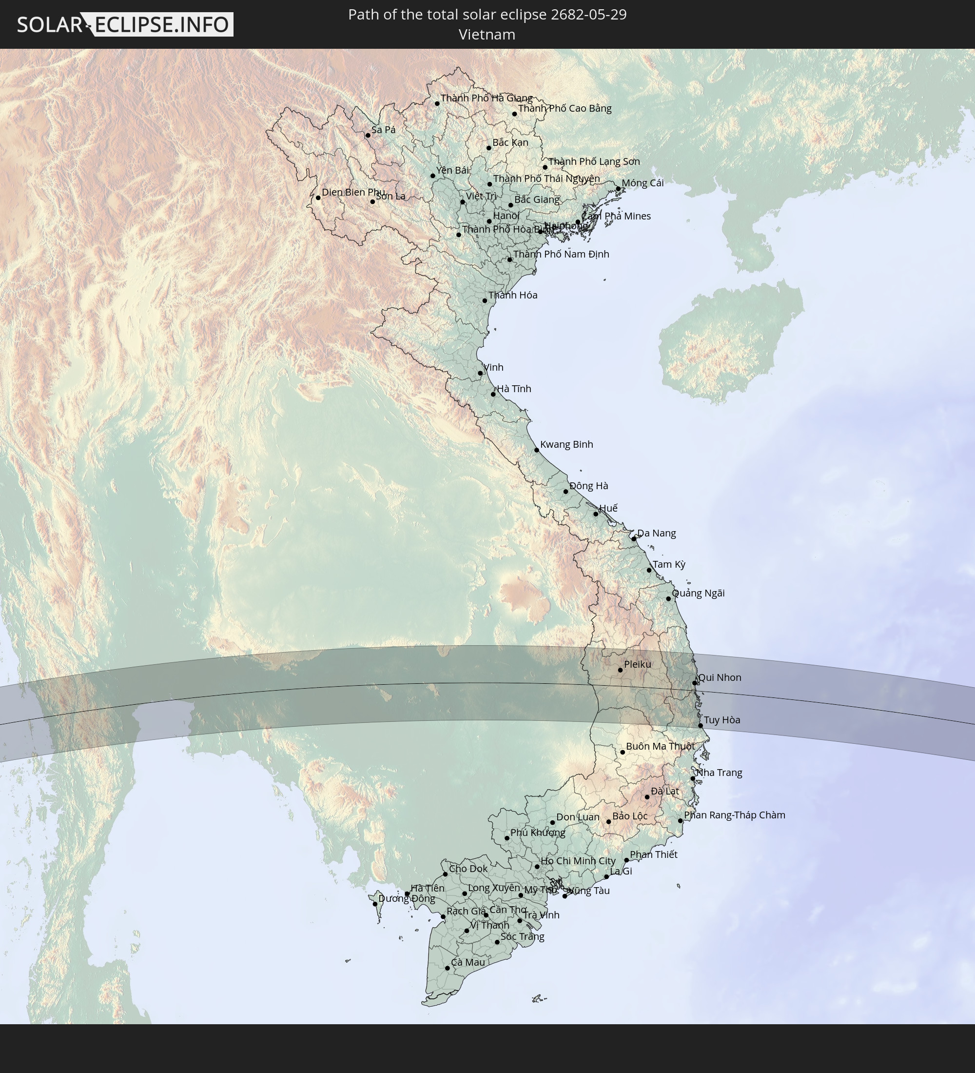 Vietnam
 Cambodia
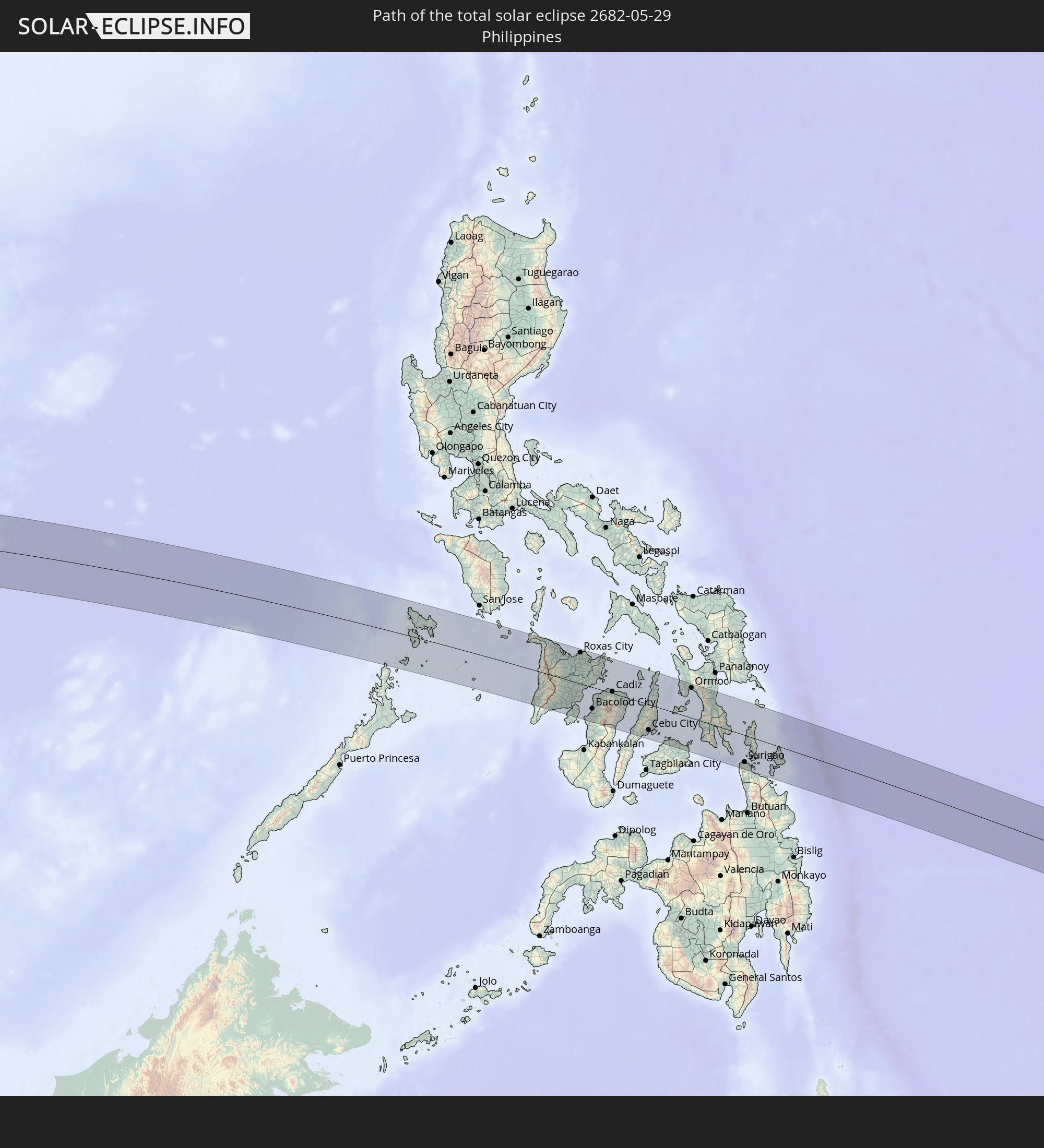 Philippines
 Palau
Palau
In den folgenden Ländern ist die Sonnenfinsternis partiell zu sehen
 Russia
 United States Minor Outlying Islands
 Sudan
Sudan
 Egypt
Egypt
 Tanzania
 Uganda
 Ethiopia
 Kenya
Kenya
 Saudi Arabia
 Eritrea
 French Southern and Antarctic Lands
 Somalia
 Djibouti
 Yemen
Yemen
 Madagascar
 Comoros
 Iran
Iran
 Mayotte
 Seychelles
 Kuwait
 Bahrain
 Qatar
Qatar
 United Arab Emirates
 Oman
Oman
 Turkmenistan
 Réunion
 Uzbekistan
 Mauritius
 Afghanistan
 Pakistan
 Tajikistan
 India
India
 Kyrgyzstan
 British Indian Ocean Territory
 Maldives
 China
China
 Sri Lanka
 Nepal
Nepal
 Mongolia
 Bangladesh
 Bhutan
 Myanmar
 Indonesia
 Cocos Islands
 Thailand
 Malaysia
 Laos
Laos
 Vietnam
 Cambodia
 Singapore
 Christmas Island
 Australia
 Macau
Macau
 Hong Kong
 Brunei
 Taiwan
 Philippines
 Japan
Japan
 East Timor
 North Korea
 South Korea
 Palau
Palau
 Federated States of Micronesia
 Papua New Guinea
 Guam
Guam
 Northern Mariana Islands
 Solomon Islands
 Marshall Islands
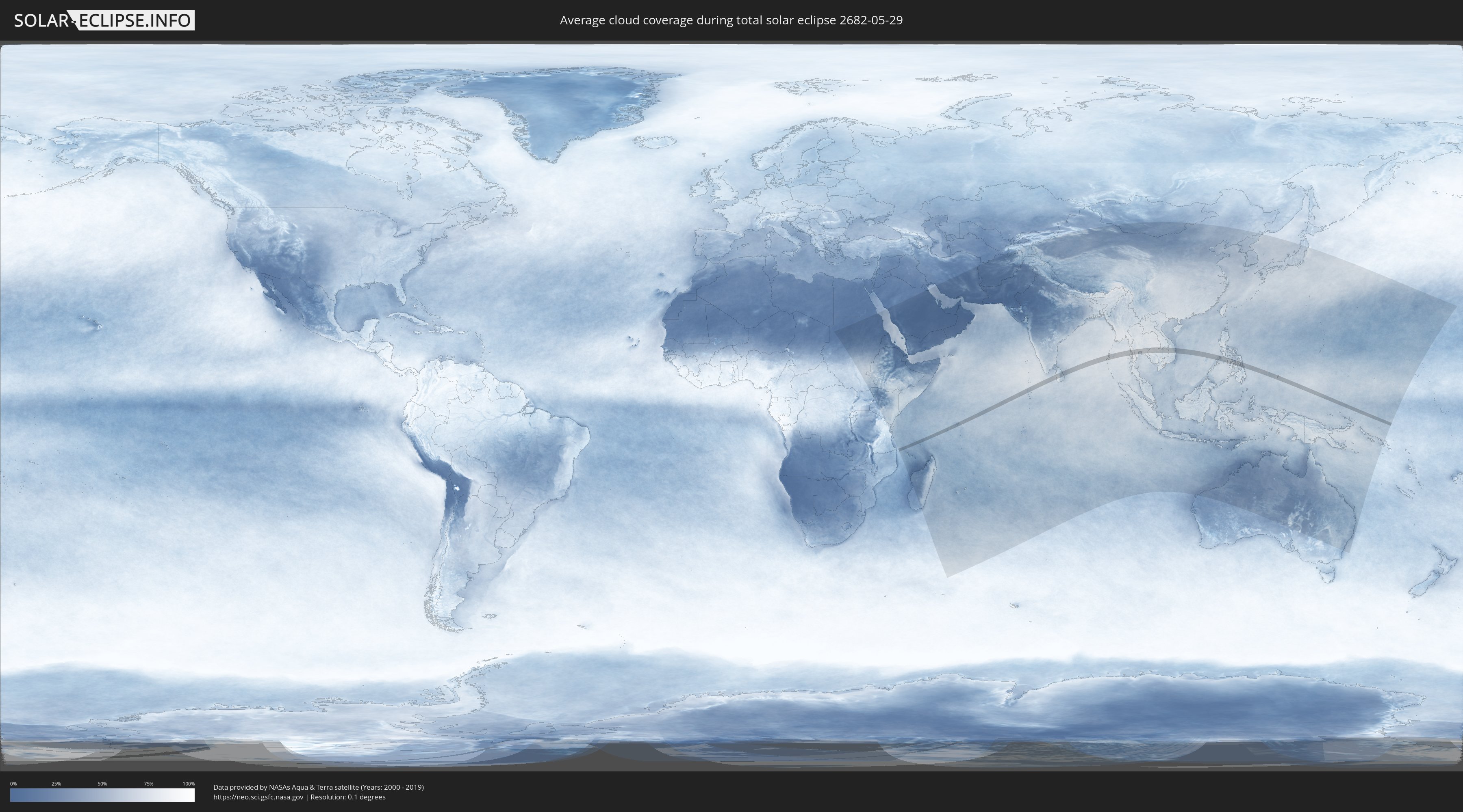
How will be the weather during the total solar eclipse on 05/29/2682?
Where is the best place to see the total solar eclipse of 05/29/2682?
The following maps show the average cloud coverage for the day of the total solar eclipse.
With the help of these maps, it is possible to find the place along the eclipse path, which has the best
chance of a cloudless sky.
Nevertheless, you should consider local circumstances and inform about the weather of your chosen
observation site.
The data is provided by NASAs satellites
AQUA and TERRA.
The cloud maps are averaged over a period of 19 years (2000 - 2019).

Detailed country maps
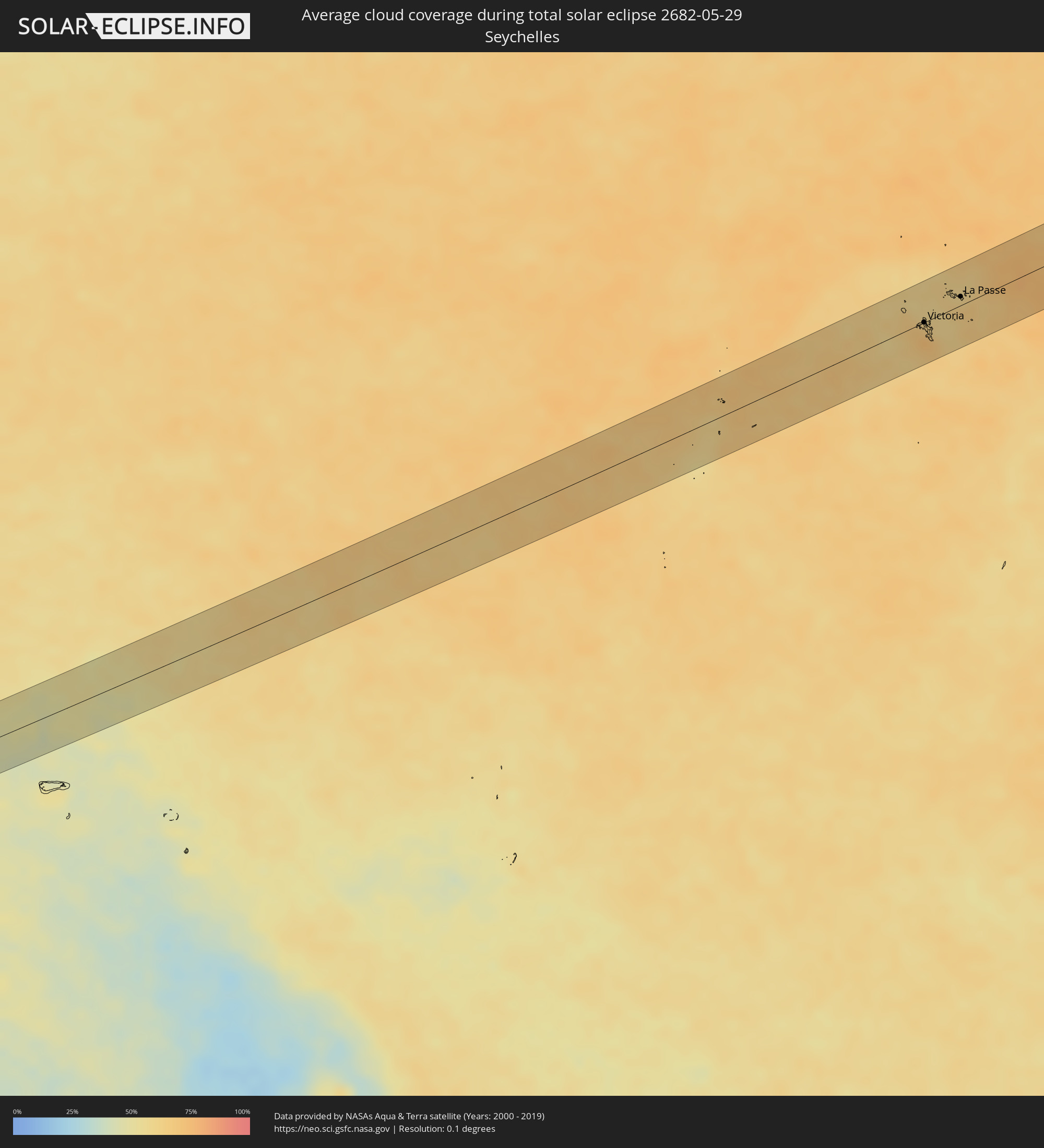 Seychelles
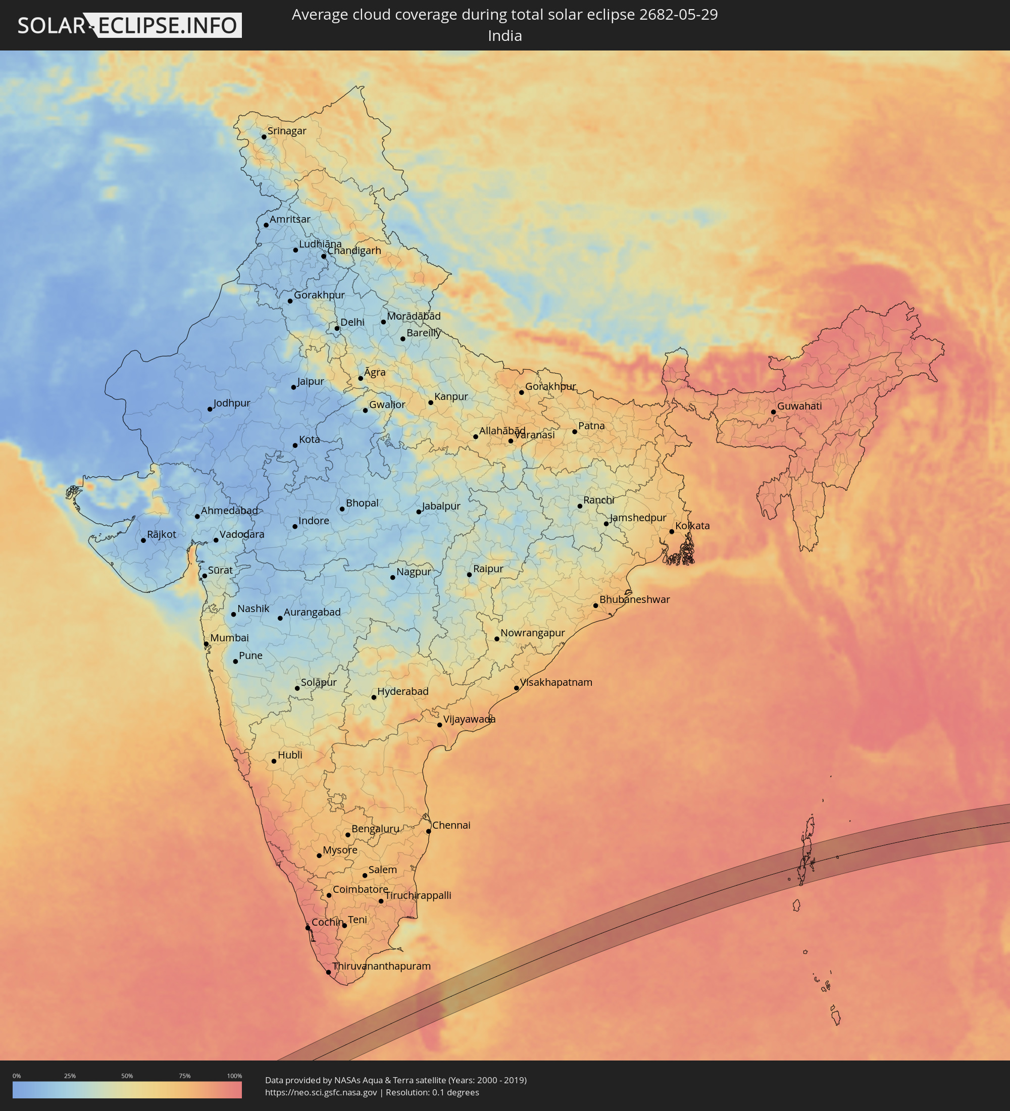 India
India
 Maldives
 Sri Lanka
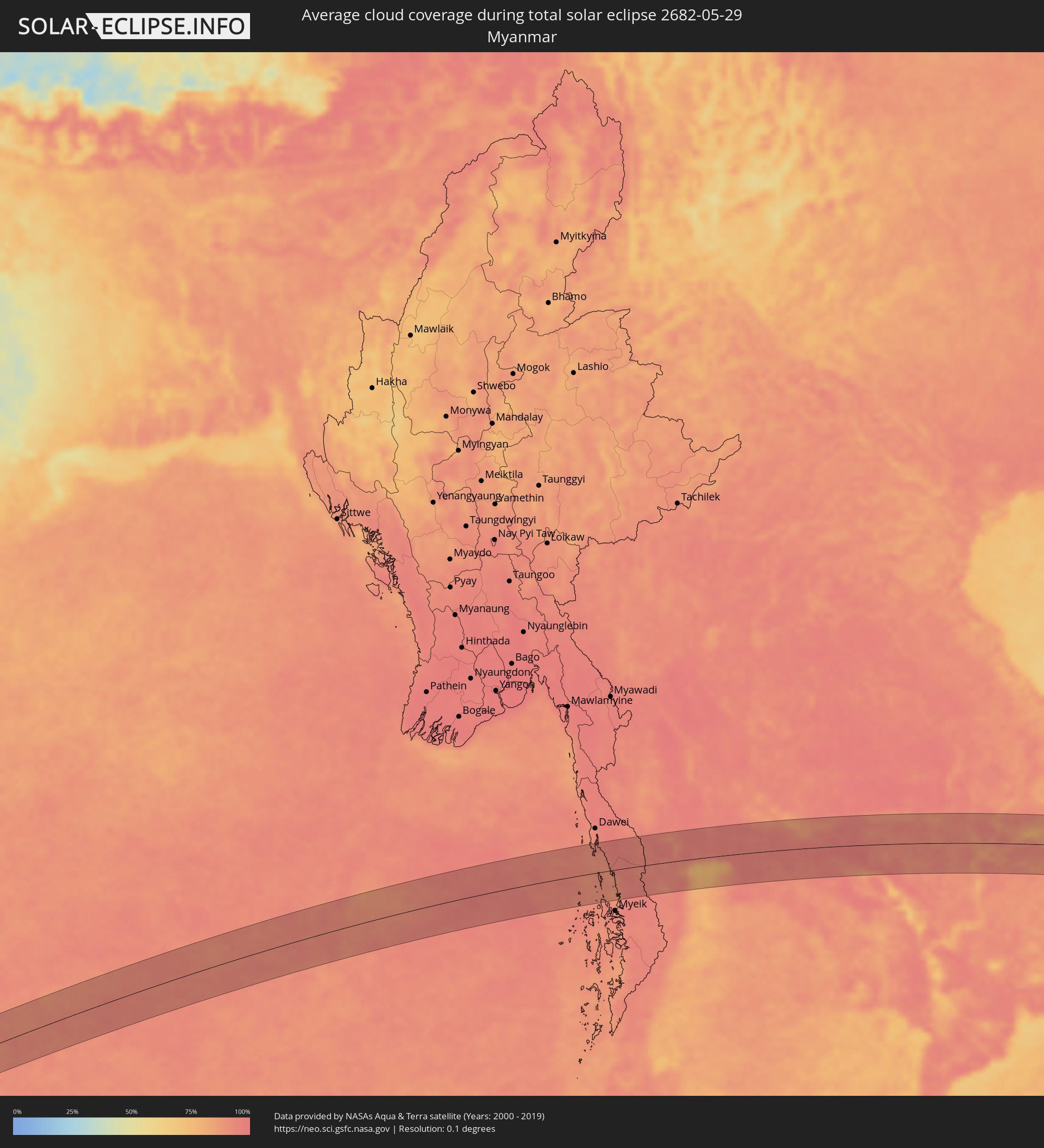 Myanmar
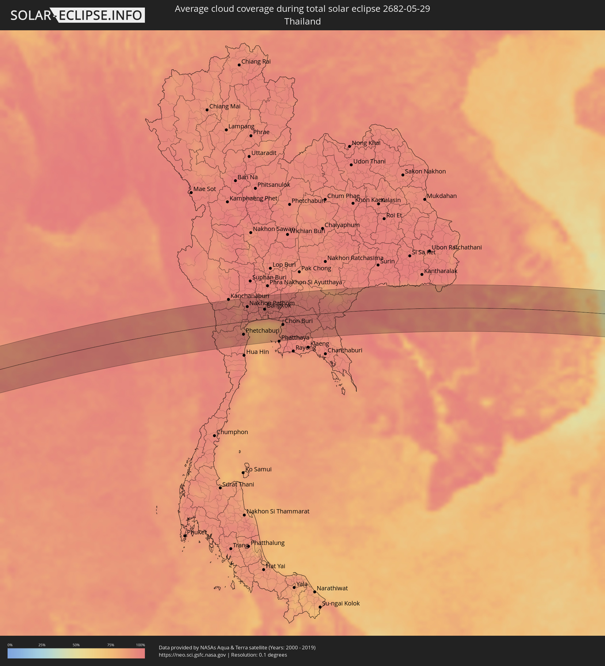 Thailand
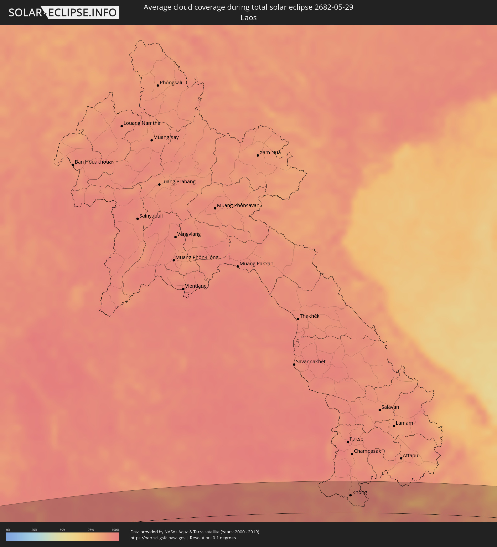 Laos
Laos
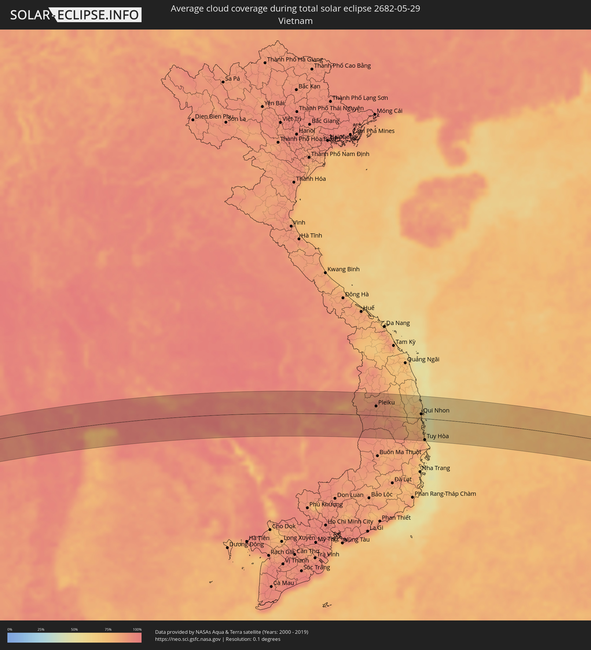 Vietnam
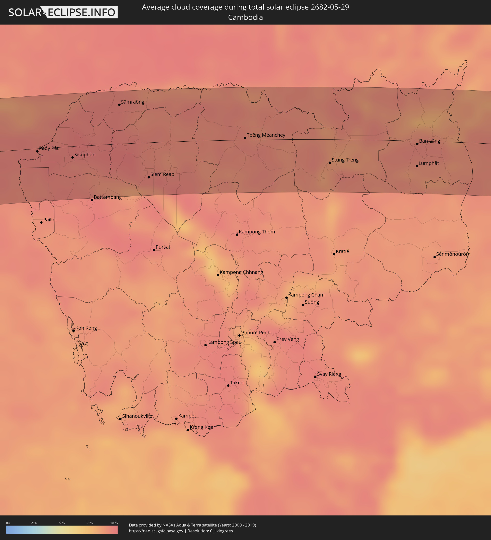 Cambodia
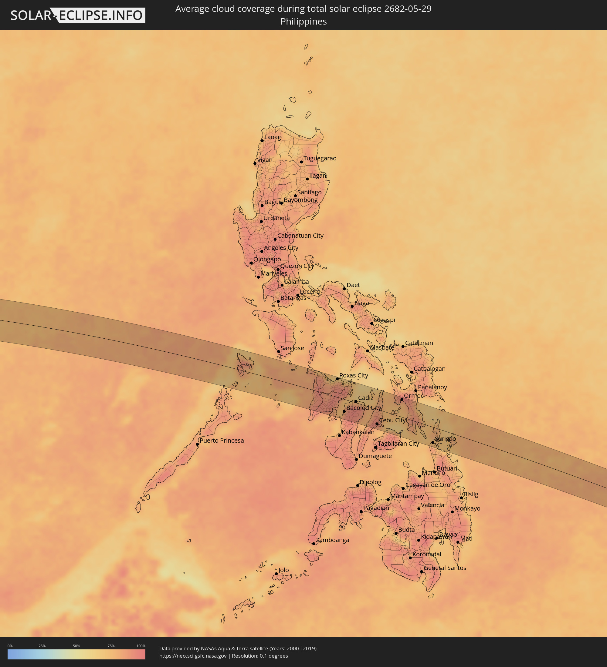 Philippines
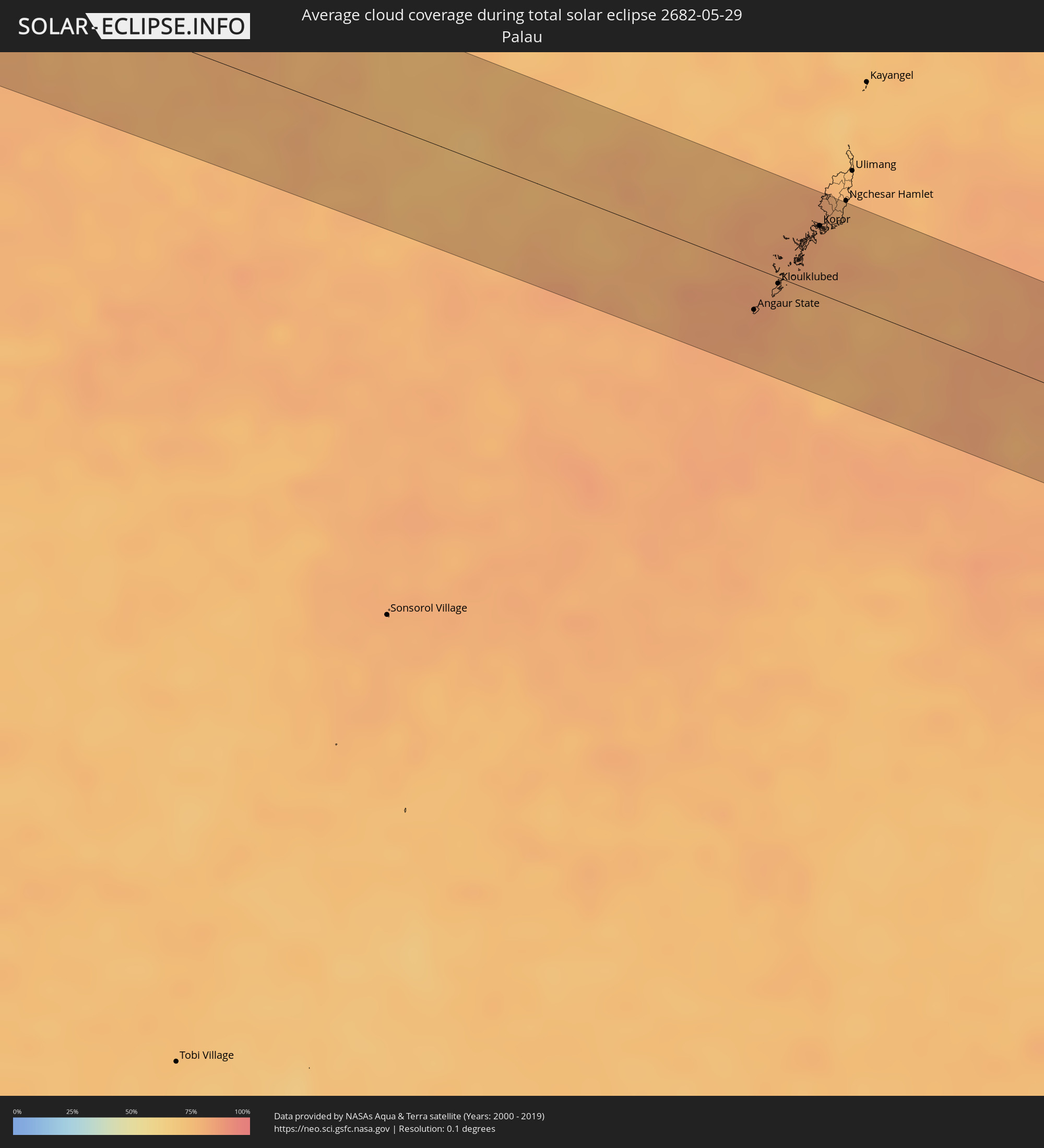 Palau
Palau
Cities inside the path of the eclipse
The following table shows all locations with a population of more than 5,000 inside the eclipse path. Cities which have more than 100,000 inhabitants are marked bold. A click at the locations opens a detailed map.
| City | Type | Eclipse duration | Local time of max. eclipse | Distance to central line | Ø Cloud coverage |
|
Bel Ombre, Bel Ombre
|
total | - | 07:35:55 UTC+04:00 | 2 km | 73% |
|
Port Glaud, Port Glaud
|
total | - | 07:35:54 UTC+04:00 | 4 km | 67% |
|
Beau Vallon, Beau Vallon
|
total | - | 07:35:56 UTC+04:00 | 1 km | 73% |
|
Victoria, English River
|
total | - | 07:35:56 UTC+04:00 | 0 km | 69% |
|
Anse Boileau, Anse Boileau
|
total | - | 07:35:55 UTC+04:00 | 12 km | 69% |
|
Takamaka, Takamaka
|
total | - | 07:35:55 UTC+04:00 | 17 km | 65% |
|
Cascade, Cascade
|
total | - | 07:35:57 UTC+04:00 | 7 km | 69% |
|
Anse Royale, Anse Royale
|
total | - | 07:35:56 UTC+04:00 | 15 km | 69% |
|
La Passe, Inner Islands
|
total | - | 07:36:14 UTC+04:00 | 9 km | 67% |
|
Male, Kaafu Atoll
|
total | - | 08:58:57 UTC+05:00 | 3 km | 82% |
|
Chilaw, North Western
|
total | - | 09:43:13 UTC+05:30 | 40 km | 86% |
|
Negombo, Western
|
total | - | 09:42:58 UTC+05:30 | 1 km | 88% |
|
Colombo, Western
|
total | - | 09:42:45 UTC+05:30 | 28 km | 89% |
|
Moratuwa, Western
|
total | - | 09:42:41 UTC+05:30 | 45 km | 88% |
|
Hendala, Western
|
total | - | 09:42:52 UTC+05:30 | 23 km | 93% |
|
Peliyagoda, Western
|
total | - | 09:42:51 UTC+05:30 | 25 km | 93% |
|
Wattala, Western
|
total | - | 09:42:52 UTC+05:30 | 25 km | 93% |
|
Ja Ela, Western
|
total | - | 09:42:58 UTC+05:30 | 15 km | 91% |
|
Kandana, Western
|
total | - | 09:42:57 UTC+05:30 | 18 km | 93% |
|
Welisara, Western
|
total | - | 09:42:56 UTC+05:30 | 20 km | 93% |
|
Panadura, Western
|
total | - | 09:42:40 UTC+05:30 | 52 km | 85% |
|
Kelaniya, Western
|
total | - | 09:42:55 UTC+05:30 | 29 km | 93% |
|
Mulleriyawa, Western
|
total | - | 09:42:55 UTC+05:30 | 31 km | 93% |
|
Homagama, Western
|
total | - | 09:42:59 UTC+05:30 | 44 km | 95% |
|
Kurunegala, North Western
|
total | - | 09:44:19 UTC+05:30 | 5 km | 92% |
|
Gampola, Central
|
total | - | 09:44:28 UTC+05:30 | 37 km | 91% |
|
Kandy, Central
|
total | - | 09:44:43 UTC+05:30 | 27 km | 91% |
|
Dambulla, Central
|
total | - | 09:45:15 UTC+05:30 | 30 km | 79% |
|
Eravur Town, Eastern Province
|
total | - | 09:47:14 UTC+05:30 | 21 km | 73% |
|
Batticaloa, Eastern Province
|
total | - | 09:47:23 UTC+05:30 | 32 km | 75% |
|
Bamboo Flat, Andaman and Nicobar Islands
|
total | - | 10:19:51 UTC+05:30 | 33 km | 92% |
|
Port Blair, Andaman and Nicobar Islands
|
total | - | 10:19:56 UTC+05:30 | 37 km | 93% |
|
Tha Maka, Kanchanaburi
|
total | - | 12:13:25 UTC+07:00 | 53 km | 90% |
|
Ratchaburi, Ratchaburi
|
total | - | 12:13:26 UTC+07:00 | 12 km | 94% |
|
Ban Pong, Ratchaburi
|
total | - | 12:13:44 UTC+07:00 | 42 km | 91% |
|
Tha Yang, Phetchaburi
|
total | - | 12:13:29 UTC+07:00 | 53 km | 94% |
|
Phetchaburi, Phetchaburi
|
total | - | 12:13:41 UTC+07:00 | 36 km | 95% |
|
Samut Songkhram, Samut Songkhram
|
total | - | 12:13:59 UTC+07:00 | 4 km | 87% |
|
Nakhon Pathom, Nakhon Pathom
|
total | - | 12:14:17 UTC+07:00 | 40 km | 95% |
|
Ban Phaeo, Samut Sakhon
|
total | - | 12:14:24 UTC+07:00 | 14 km | 94% |
|
Krathum Baen, Samut Sakhon
|
total | - | 12:14:55 UTC+07:00 | 19 km | 94% |
|
Pak Kret, Nonthaburi
|
total | - | 12:15:48 UTC+07:00 | 45 km | 94% |
|
Bangkok, Bangkok
|
total | - | 12:15:45 UTC+07:00 | 27 km | 95% |
|
Samut Prakan, Samut Prakan
|
total | - | 12:16:00 UTC+07:00 | 9 km | 89% |
|
Khlong Luang, Pathum Thani
|
total | - | 12:16:20 UTC+07:00 | 60 km | 94% |
|
Ban Lam Luk Ka, Pathum Thani
|
total | - | 12:16:44 UTC+07:00 | 49 km | 95% |
|
Ban Khlong Bang Sao Thong, Samut Prakan
|
total | - | 12:16:47 UTC+07:00 | 11 km | 94% |
|
Si Racha, Chon Buri
|
total | - | 12:16:57 UTC+07:00 | 42 km | 89% |
|
Chon Buri, Chon Buri
|
total | - | 12:17:11 UTC+07:00 | 22 km | 91% |
|
Chachoengsao, Chachoengsao
|
total | - | 12:17:35 UTC+07:00 | 14 km | 95% |
|
Prachin Buri, Prachin Buri
|
total | - | 12:18:40 UTC+07:00 | 50 km | 93% |
|
Sa Kaeo, Sa Kaeo
|
total | - | 12:20:54 UTC+07:00 | 18 km | 96% |
|
Paôy Pêt, Banteay Meanchey
|
total | - | 12:22:28 UTC+07:00 | 4 km | 95% |
|
Sisŏphŏn, Banteay Meanchey
|
total | - | 12:23:47 UTC+07:00 | 14 km | 93% |
|
Sâmraông, Ŏtâr Méanchey
|
total | - | 12:25:41 UTC+07:00 | 49 km | 96% |
|
Siem Reap, Siem Reap
|
total | - | 12:26:40 UTC+07:00 | 44 km | 94% |
|
Tbêng Méanchey, Preah Vihear
|
total | - | 12:30:23 UTC+07:00 | 2 km | 94% |
|
Không, Champasak
|
total | - | 12:33:13 UTC+07:00 | 36 km | 89% |
|
Stung Treng, Stung Treng
|
total | - | 12:33:34 UTC+07:00 | 30 km | 89% |
|
Lumphăt, Ratanakiri
|
total | - | 12:36:50 UTC+07:00 | 32 km | 88% |
|
Ban Lŭng, Ratanakiri
|
total | - | 12:36:51 UTC+07:00 | 4 km | 93% |
|
Pleiku, Gia Lai
|
total | - | 12:40:03 UTC+07:00 | 27 km | 88% |
|
Sông Cầu, Phú Yên
|
total | - | 12:43:55 UTC+07:00 | 23 km | 73% |
|
Qui Nhon, Bình Định
|
total | - | 12:43:53 UTC+07:00 | 12 km | 68% |
|
Tuy Hòa, Phú Yên
|
total | - | 12:44:16 UTC+07:00 | 62 km | 82% |
|
Pandan, Western Visayas
|
total | - | 14:19:22 UTC+08:00 | 51 km | 87% |
|
Kalibo (poblacion), Western Visayas
|
total | - | 14:19:58 UTC+08:00 | 55 km | 76% |
|
Iloilo, Western Visayas
|
total | - | 14:20:57 UTC+08:00 | 46 km | 84% |
|
Passi, Western Visayas
|
total | - | 14:20:54 UTC+08:00 | 0 km | 93% |
|
Roxas City, Western Visayas
|
total | - | 14:20:53 UTC+08:00 | 54 km | 83% |
|
Bago City, Western Visayas
|
total | - | 14:21:38 UTC+08:00 | 55 km | 76% |
|
Bacolod City, Western Visayas
|
total | - | 14:21:49 UTC+08:00 | 37 km | 91% |
|
Maao, Western Visayas
|
total | - | 14:22:00 UTC+08:00 | 55 km | 92% |
|
Victorias, Western Visayas
|
total | - | 14:21:57 UTC+08:00 | 9 km | 90% |
|
Canlaon, Central Visayas
|
total | - | 14:22:33 UTC+08:00 | 59 km | 88% |
|
Cadiz, Western Visayas
|
total | - | 14:22:23 UTC+08:00 | 3 km | 91% |
|
Ualog, Western Visayas
|
total | - | 14:22:49 UTC+08:00 | 33 km | 84% |
|
Escalante, Western Visayas
|
total | - | 14:22:54 UTC+08:00 | 2 km | 83% |
|
Toledo, Central Visayas
|
total | - | 14:23:26 UTC+08:00 | 46 km | 82% |
|
Balamban, Central Visayas
|
total | - | 14:23:32 UTC+08:00 | 30 km | 87% |
|
Cebu City, Central Visayas
|
total | - | 14:24:00 UTC+08:00 | 45 km | 82% |
|
Bogo, Central Visayas
|
total | - | 14:23:50 UTC+08:00 | 37 km | 81% |
|
Danao, Central Visayas
|
total | - | 14:24:11 UTC+08:00 | 18 km | 81% |
|
Ormoc, Eastern Visayas
|
total | - | 14:25:06 UTC+08:00 | 52 km | 78% |
|
Surigao, Caraga
|
total | - | 14:27:33 UTC+08:00 | 47 km | 76% |
|
Angaur State, Angaur
|
total | - | 15:43:16 UTC+09:00 | 22 km | 83% |
|
Kloulklubed, Peleliu
|
total | - | 15:43:22 UTC+09:00 | 3 km | 80% |
|
Koror, Koror
|
total | - | 15:43:30 UTC+09:00 | 36 km | 80% |
|
Ngchemiangel, Aimeliik
|
total | - | 15:43:27 UTC+09:00 | 48 km | 82% |
|
Koror Town, Koror
|
total | - | 15:43:30 UTC+09:00 | 37 km | 80% |
|
Ngereklmadel, Ngatpang
|
total | - | 15:43:26 UTC+09:00 | 52 km | 82% |
|
Ngetkib, Airai
|
total | - | 15:43:32 UTC+09:00 | 41 km | 82% |