Total solar eclipse of 07/31/2744
| Day of week: | Monday |
| Maximum duration of eclipse: | 05m59s |
| Maximum width of eclipse path: | 276 km |
| Saros cycle: | 167 |
| Coverage: | 100% |
| Magnitude: | 1.0778 |
| Gamma: | 0.4082 |
Wo kann man die Sonnenfinsternis vom 07/31/2744 sehen?

Die Sonnenfinsternis am 07/31/2744 kann man in 55 Ländern als partielle Sonnenfinsternis beobachten.
Der Finsternispfad verläuft durch ein Land. Nur in diesem Land ist sie als total Sonnenfinsternis zu sehen.
In den folgenden Ländern ist die Sonnenfinsternis total zu sehen
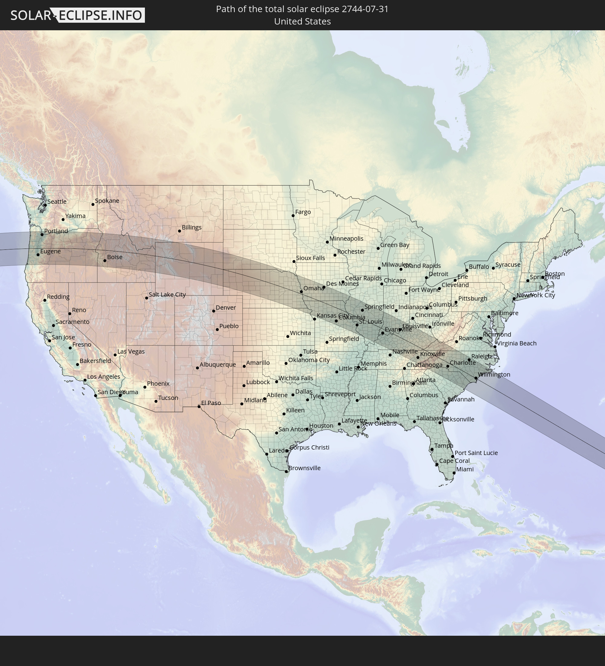 United States
In den folgenden Ländern ist die Sonnenfinsternis partiell zu sehen
 Russia
 United States
 United States Minor Outlying Islands
 Canada
 Mexico
 Greenland
 Guatemala
 Ecuador
 El Salvador
 Honduras
 Belize
 Nicaragua
 Costa Rica
 Cuba
Cuba
 Panama
 Colombia
 Cayman Islands
 Peru
Peru
 The Bahamas
 Jamaica
 Haiti
Haiti
 Brazil
 Venezuela
 Turks and Caicos Islands
 Dominican Republic
 Aruba
Aruba
 Puerto Rico
 United States Virgin Islands
 Bermuda
 British Virgin Islands
 Anguilla
 Collectivity of Saint Martin
 Saint Barthélemy
 Saint Kitts and Nevis
 Antigua and Barbuda
 Montserrat
 Trinidad and Tobago
 Guadeloupe
 Grenada
 Dominica
 Saint Vincent and the Grenadines
 Guyana
 Martinique
 Saint Lucia
 Barbados
 Suriname
 Saint Pierre and Miquelon
 French Guiana
 Portugal
 Iceland
 Republic of Ireland
 United Kingdom
 Faroe Islands
 France
 Isle of Man
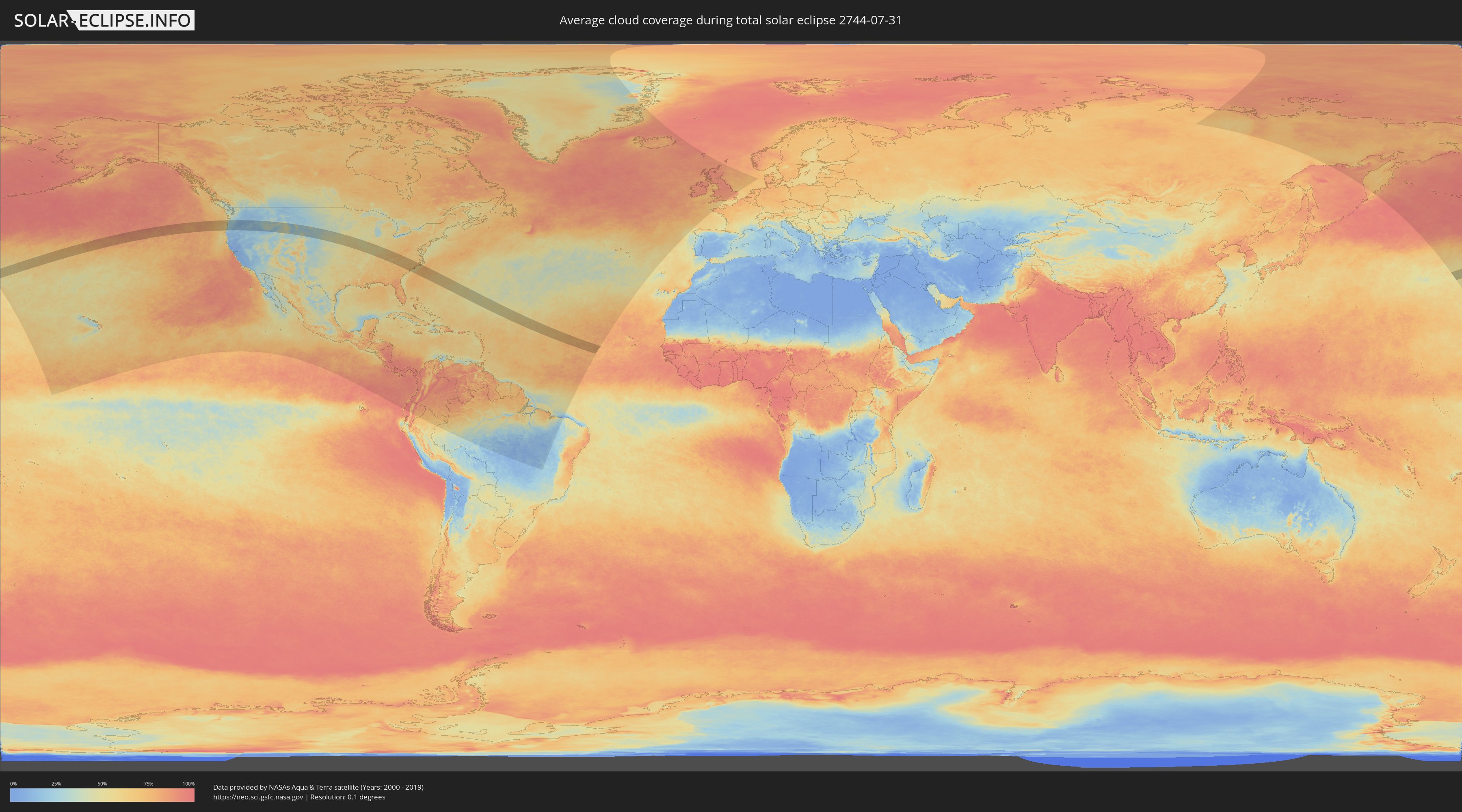
How will be the weather during the total solar eclipse on 07/31/2744?
Where is the best place to see the total solar eclipse of 07/31/2744?
The following maps show the average cloud coverage for the day of the total solar eclipse.
With the help of these maps, it is possible to find the place along the eclipse path, which has the best
chance of a cloudless sky.
Nevertheless, you should consider local circumstances and inform about the weather of your chosen
observation site.
The data is provided by NASAs satellites
AQUA and TERRA.
The cloud maps are averaged over a period of 19 years (2000 - 2019).

Detailed country maps
 United States
Cities inside the path of the eclipse
The following table shows all locations with a population of more than 5,000 inside the eclipse path. Cities which have more than 100,000 inhabitants are marked bold. A click at the locations opens a detailed map.
| City | Type | Eclipse duration | Local time of max. eclipse | Distance to central line | Ø Cloud coverage |
|
Coos Bay, Oregon
|
total | - | 10:16:02 UTC-08:00 | 131 km | 30% |
|
Dallas, Oregon
|
total | - | 10:18:17 UTC-08:00 | 40 km | 23% |
|
Corvallis, Oregon
|
total | - | 10:18:11 UTC-08:00 | 1 km | 26% |
|
McMinnville, Oregon
|
total | - | 10:18:38 UTC-08:00 | 73 km | 27% |
|
Eugene, Oregon
|
total | - | 10:18:11 UTC-08:00 | 56 km | 22% |
|
Salem, Oregon
|
total | - | 10:18:44 UTC-08:00 | 43 km | 24% |
|
Hillsboro, Oregon
|
total | - | 10:19:07 UTC-08:00 | 107 km | 28% |
|
Newberg, Oregon
|
total | - | 10:19:01 UTC-08:00 | 82 km | 27% |
|
Lebanon, Oregon
|
total | - | 10:18:43 UTC-08:00 | 3 km | 23% |
|
Woodburn, Oregon
|
total | - | 10:19:07 UTC-08:00 | 65 km | 25% |
|
Portland, Oregon
|
total | - | 10:19:35 UTC-08:00 | 107 km | 27% |
|
Salmon Creek, Washington
|
total | - | 10:19:44 UTC-08:00 | 128 km | 29% |
|
Oregon City, Oregon
|
total | - | 10:19:37 UTC-08:00 | 88 km | 28% |
|
Gresham, Oregon
|
total | - | 10:19:57 UTC-08:00 | 104 km | 29% |
|
Bend, Oregon
|
total | - | 10:21:02 UTC-08:00 | 56 km | 16% |
|
The Dalles, Oregon
|
total | - | 10:21:56 UTC-08:00 | 115 km | 15% |
|
Redmond, Oregon
|
total | - | 10:21:21 UTC-08:00 | 32 km | 13% |
|
Pendleton, Oregon
|
total | - | 10:25:46 UTC-08:00 | 128 km | 14% |
|
La Grande, Oregon
|
total | - | 10:26:47 UTC-08:00 | 92 km | 15% |
|
Ontario, Oregon
|
total | - | 11:28:20 UTC-07:00 | 47 km | 19% |
|
Caldwell, Idaho
|
total | - | 11:28:44 UTC-07:00 | 86 km | 20% |
|
Nampa, Idaho
|
total | - | 11:28:56 UTC-07:00 | 99 km | 18% |
|
Meridian, Idaho
|
total | - | 11:29:15 UTC-07:00 | 90 km | 17% |
|
Boise, Idaho
|
total | - | 11:29:35 UTC-07:00 | 89 km | 16% |
|
Chubbuck, Idaho
|
total | - | 11:36:18 UTC-07:00 | 134 km | 28% |
|
Blackfoot, Idaho
|
total | - | 11:36:31 UTC-07:00 | 103 km | 24% |
|
Idaho Falls, Idaho
|
total | - | 11:37:05 UTC-07:00 | 69 km | 22% |
|
Rexburg, Idaho
|
total | - | 11:37:31 UTC-07:00 | 27 km | 23% |
|
Riverton, Wyoming
|
total | - | 11:43:58 UTC-07:00 | 71 km | 24% |
|
Casper, Wyoming
|
total | - | 11:47:56 UTC-07:00 | 54 km | 29% |
|
Gillette, Wyoming
|
total | - | 11:48:55 UTC-07:00 | 115 km | 28% |
|
Scottsbluff, Nebraska
|
total | - | 11:53:28 UTC-07:00 | 112 km | 20% |
|
Rapid City, South Dakota
|
total | - | 11:53:10 UTC-07:00 | 135 km | 34% |
|
North Platte, Nebraska
|
total | - | 12:59:35 UTC-06:00 | 127 km | 37% |
|
Kearney, Nebraska
|
total | - | 13:03:12 UTC-06:00 | 129 km | 43% |
|
Hastings, Nebraska
|
total | - | 13:04:38 UTC-06:00 | 123 km | 44% |
|
Grand Island, Nebraska
|
total | - | 13:04:27 UTC-06:00 | 86 km | 43% |
|
Norfolk, Nebraska
|
total | - | 13:05:17 UTC-06:00 | 55 km | 48% |
|
Columbus, Nebraska
|
total | - | 13:05:53 UTC-06:00 | 6 km | 45% |
|
Beatrice, Nebraska
|
total | - | 13:08:06 UTC-06:00 | 110 km | 49% |
|
Lincoln, Nebraska
|
total | - | 13:07:46 UTC-06:00 | 52 km | 52% |
|
Fremont, Nebraska
|
total | - | 13:07:31 UTC-06:00 | 19 km | 46% |
|
Sioux City, Iowa
|
total | - | 13:06:45 UTC-06:00 | 133 km | 48% |
|
Chalco, Nebraska
|
total | - | 13:08:23 UTC-06:00 | 3 km | 50% |
|
Omaha, Nebraska
|
total | - | 13:08:43 UTC-06:00 | 16 km | 53% |
|
Atchison, Kansas
|
total | - | 13:11:54 UTC-06:00 | 136 km | 52% |
|
Maryville, Missouri
|
total | - | 13:11:35 UTC-06:00 | 47 km | 52% |
|
Saint Joseph, Missouri
|
total | - | 13:12:13 UTC-06:00 | 106 km | 56% |
|
Excelsior Springs, Missouri
|
total | - | 13:13:50 UTC-06:00 | 131 km | 50% |
|
Waukee, Iowa
|
total | - | 13:12:08 UTC-06:00 | 115 km | 50% |
|
Des Moines, Iowa
|
total | - | 13:12:39 UTC-06:00 | 122 km | 54% |
|
Indianola, Iowa
|
total | - | 13:12:59 UTC-06:00 | 99 km | 52% |
|
Marshall, Missouri
|
total | - | 13:16:01 UTC-06:00 | 120 km | 56% |
|
Pella, Iowa
|
total | - | 13:14:05 UTC-06:00 | 124 km | 51% |
|
Oskaloosa, Iowa
|
total | - | 13:14:41 UTC-06:00 | 122 km | 50% |
|
Kirksville, Missouri
|
total | - | 13:15:59 UTC-06:00 | 10 km | 55% |
|
Moberly, Missouri
|
total | - | 13:17:06 UTC-06:00 | 64 km | 58% |
|
Ottumwa, Iowa
|
total | - | 13:15:24 UTC-06:00 | 101 km | 49% |
|
Columbia, Missouri
|
total | - | 13:17:49 UTC-06:00 | 109 km | 61% |
|
Fulton, Missouri
|
total | - | 13:18:39 UTC-06:00 | 107 km | 58% |
|
Mexico, Missouri
|
total | - | 13:18:25 UTC-06:00 | 71 km | 58% |
|
Quincy, Illinois
|
total | - | 13:18:24 UTC-06:00 | 23 km | 45% |
|
Keokuk, Iowa
|
total | - | 13:17:55 UTC-06:00 | 71 km | 47% |
|
Hannibal, Missouri
|
total | - | 13:18:45 UTC-06:00 | 2 km | 52% |
|
Fort Madison, Iowa
|
total | - | 13:17:47 UTC-06:00 | 97 km | 43% |
|
Burlington, Iowa
|
total | - | 13:17:56 UTC-06:00 | 122 km | 46% |
|
Washington, Missouri
|
total | - | 13:20:43 UTC-06:00 | 104 km | 51% |
|
Troy, Missouri
|
total | - | 13:20:17 UTC-06:00 | 60 km | 55% |
|
O'Fallon, Missouri
|
total | - | 13:21:00 UTC-06:00 | 67 km | 57% |
|
Macomb, Illinois
|
total | - | 13:19:07 UTC-06:00 | 102 km | 50% |
|
Chesterfield, Missouri
|
total | - | 13:21:24 UTC-06:00 | 78 km | 55% |
|
Saint Charles, Missouri
|
total | - | 13:21:25 UTC-06:00 | 62 km | 54% |
|
Kirkwood, Missouri
|
total | - | 13:21:48 UTC-06:00 | 80 km | 58% |
|
Festus, Missouri
|
total | - | 13:22:15 UTC-06:00 | 116 km | 57% |
|
Ferguson, Missouri
|
total | - | 13:21:47 UTC-06:00 | 60 km | 57% |
|
Oakville, Missouri
|
total | - | 13:22:07 UTC-06:00 | 88 km | 53% |
|
Jacksonville, Illinois
|
total | - | 13:20:45 UTC-06:00 | 43 km | 49% |
|
St. Louis, Missouri
|
total | - | 13:22:07 UTC-06:00 | 68 km | 54% |
|
Upper Alton, Illinois
|
total | - | 13:21:52 UTC-06:00 | 37 km | 46% |
|
Canton, Illinois
|
total | - | 13:20:07 UTC-06:00 | 134 km | 51% |
|
Collinsville, Illinois
|
total | - | 13:22:27 UTC-06:00 | 56 km | 56% |
|
Belleville, Illinois
|
total | - | 13:22:38 UTC-06:00 | 71 km | 54% |
|
Edwardsville, Illinois
|
total | - | 13:22:20 UTC-06:00 | 40 km | 51% |
|
Springfield, Illinois
|
total | - | 13:21:42 UTC-06:00 | 71 km | 53% |
|
Lincoln, Illinois
|
total | - | 13:21:46 UTC-06:00 | 116 km | 55% |
|
Taylorville, Illinois
|
total | - | 13:22:37 UTC-06:00 | 58 km | 47% |
|
Carbondale, Illinois
|
total | - | 13:25:00 UTC-06:00 | 123 km | 50% |
|
Centralia, Illinois
|
total | - | 13:24:09 UTC-06:00 | 40 km | 54% |
|
Decatur, Illinois
|
total | - | 13:22:51 UTC-06:00 | 100 km | 53% |
|
Marion, Illinois
|
total | - | 13:25:31 UTC-06:00 | 112 km | 52% |
|
Mount Vernon, Illinois
|
total | - | 13:24:49 UTC-06:00 | 52 km | 52% |
|
Effingham, Illinois
|
total | - | 13:24:27 UTC-06:00 | 42 km | 54% |
|
Mattoon, Illinois
|
total | - | 13:24:17 UTC-06:00 | 85 km | 55% |
|
Charleston, Illinois
|
total | - | 13:24:37 UTC-06:00 | 93 km | 55% |
|
Henderson, Kentucky
|
total | - | 13:27:45 UTC-06:00 | 51 km | 53% |
|
Evansville, Indiana
|
total | - | 13:27:38 UTC-06:00 | 36 km | 50% |
|
Vincennes, Indiana
|
total | - | 14:26:46 UTC-05:00 | 35 km | 54% |
|
Madisonville, Kentucky
|
total | - | 13:28:34 UTC-06:00 | 99 km | 60% |
|
Terre Haute, Indiana
|
total | - | 14:25:57 UTC-05:00 | 119 km | 58% |
|
Washington, Indiana
|
total | - | 14:27:24 UTC-05:00 | 47 km | 56% |
|
Owensboro, Kentucky
|
total | - | 13:28:39 UTC-06:00 | 39 km | 56% |
|
Jasper, Indiana
|
total | - | 14:28:09 UTC-05:00 | 30 km | 57% |
|
Bloomington, Indiana
|
total | - | 14:27:49 UTC-05:00 | 122 km | 55% |
|
Portland, Tennessee
|
total | - | 13:31:17 UTC-06:00 | 135 km | 68% |
|
Bedford, Indiana
|
total | - | 14:28:17 UTC-05:00 | 94 km | 55% |
|
Bowling Green, Kentucky
|
total | - | 13:30:51 UTC-06:00 | 91 km | 67% |
|
Radcliff, Kentucky
|
total | - | 14:30:33 UTC-05:00 | 13 km | 62% |
|
Glasgow, Kentucky
|
total | - | 13:31:46 UTC-06:00 | 70 km | 63% |
|
Seymour, Indiana
|
total | - | 14:29:09 UTC-05:00 | 127 km | 53% |
|
Valley Station, Kentucky
|
total | - | 14:30:19 UTC-05:00 | 43 km | 54% |
|
Elizabethtown, Kentucky
|
total | - | 14:30:54 UTC-05:00 | 2 km | 61% |
|
Louisville, Kentucky
|
total | - | 14:30:19 UTC-05:00 | 62 km | 59% |
|
Shepherdsville, Kentucky
|
total | - | 14:30:45 UTC-05:00 | 37 km | 59% |
|
Jeffersontown, Kentucky
|
total | - | 14:30:43 UTC-05:00 | 63 km | 59% |
|
Cookeville, Tennessee
|
total | - | 13:33:36 UTC-06:00 | 136 km | 67% |
|
Bardstown, Kentucky
|
total | - | 14:31:24 UTC-05:00 | 29 km | 61% |
|
North Madison, Indiana
|
total | - | 14:30:13 UTC-05:00 | 127 km | 56% |
|
Shelbyville, Kentucky
|
total | - | 14:31:15 UTC-05:00 | 79 km | 61% |
|
Crossville, Tennessee
|
total | - | 13:34:42 UTC-06:00 | 138 km | 73% |
|
Lawrenceburg, Kentucky
|
total | - | 14:32:02 UTC-05:00 | 74 km | 61% |
|
Frankfort, Kentucky
|
total | - | 14:31:51 UTC-05:00 | 91 km | 62% |
|
Danville, Kentucky
|
total | - | 14:32:46 UTC-05:00 | 41 km | 67% |
|
Somerset, Kentucky
|
total | - | 14:33:49 UTC-05:00 | 7 km | 64% |
|
Nicholasville, Kentucky
|
total | - | 14:32:46 UTC-05:00 | 72 km | 62% |
|
Georgetown, Kentucky
|
total | - | 14:32:20 UTC-05:00 | 105 km | 58% |
|
Lexington-Fayette, Kentucky
|
total | - | 14:32:43 UTC-05:00 | 93 km | 61% |
|
Berea, Kentucky
|
total | - | 14:33:39 UTC-05:00 | 52 km | 68% |
|
Richmond, Kentucky
|
total | - | 14:33:24 UTC-05:00 | 70 km | 66% |
|
Oak Ridge, Tennessee
|
total | - | 14:35:53 UTC-05:00 | 101 km | 60% |
|
Winchester, Kentucky
|
total | - | 14:33:15 UTC-05:00 | 99 km | 62% |
|
Farragut, Tennessee
|
total | - | 14:36:15 UTC-05:00 | 108 km | 59% |
|
Maryville, Tennessee
|
total | - | 14:36:44 UTC-05:00 | 113 km | 64% |
|
Knoxville, Tennessee
|
total | - | 14:36:32 UTC-05:00 | 91 km | 64% |
|
Middlesboro, Kentucky
|
total | - | 14:35:57 UTC-05:00 | 19 km | 67% |
|
Sevierville, Tennessee
|
total | - | 14:37:15 UTC-05:00 | 85 km | 60% |
|
Morristown, Tennessee
|
total | - | 14:37:11 UTC-05:00 | 40 km | 61% |
|
Greeneville, Tennessee
|
total | - | 14:38:00 UTC-05:00 | 25 km | 61% |
|
Kingsport, Tennessee
|
total | - | 14:37:53 UTC-05:00 | 24 km | 64% |
|
Asheville, North Carolina
|
total | - | 14:39:15 UTC-05:00 | 69 km | 63% |
|
Hendersonville, North Carolina
|
total | - | 14:39:49 UTC-05:00 | 93 km | 68% |
|
Greenville, South Carolina
|
total | - | 14:40:36 UTC-05:00 | 135 km | 71% |
|
Johnson City, Tennessee
|
total | - | 14:38:33 UTC-05:00 | 10 km | 67% |
|
Greer, South Carolina
|
total | - | 14:40:45 UTC-05:00 | 120 km | 70% |
|
Bristol, Tennessee
|
total | - | 14:38:24 UTC-05:00 | 44 km | 66% |
|
Spartanburg, South Carolina
|
total | - | 14:41:12 UTC-05:00 | 106 km | 67% |
|
Morganton, North Carolina
|
total | - | 14:40:25 UTC-05:00 | 17 km | 67% |
|
Boone, North Carolina
|
total | - | 14:39:44 UTC-05:00 | 29 km | 72% |
|
Gaffney, South Carolina
|
total | - | 14:41:27 UTC-05:00 | 82 km | 69% |
|
Lenoir, North Carolina
|
total | - | 14:40:24 UTC-05:00 | 5 km | 68% |
|
Shelby, North Carolina
|
total | - | 14:41:19 UTC-05:00 | 55 km | 67% |
|
Hickory, North Carolina
|
total | - | 14:40:58 UTC-05:00 | 4 km | 66% |
|
Lincolnton, North Carolina
|
total | - | 14:41:29 UTC-05:00 | 25 km | 67% |
|
Gastonia, North Carolina
|
total | - | 14:41:54 UTC-05:00 | 43 km | 67% |
|
Rock Hill, South Carolina
|
total | - | 14:42:39 UTC-05:00 | 69 km | 69% |
|
Mount Holly, North Carolina
|
total | - | 14:42:06 UTC-05:00 | 32 km | 66% |
|
Statesville, North Carolina
|
total | - | 14:41:35 UTC-05:00 | 21 km | 66% |
|
Charlotte, North Carolina
|
total | - | 14:42:28 UTC-05:00 | 32 km | 74% |
|
Huntersville, North Carolina
|
total | - | 14:42:12 UTC-05:00 | 14 km | 72% |
|
Mooresville, North Carolina
|
total | - | 14:42:00 UTC-05:00 | 5 km | 63% |
|
Indian Trail, North Carolina
|
total | - | 14:42:58 UTC-05:00 | 39 km | 72% |
|
Mount Airy, North Carolina
|
total | - | 14:40:57 UTC-05:00 | 103 km | 67% |
|
Concord, North Carolina
|
total | - | 14:42:36 UTC-05:00 | 2 km | 71% |
|
Salisbury, North Carolina
|
total | - | 14:42:23 UTC-05:00 | 28 km | 68% |
|
Clemmons, North Carolina
|
total | - | 14:42:00 UTC-05:00 | 66 km | 65% |
|
Sumter, South Carolina
|
total | - | 14:45:11 UTC-05:00 | 137 km | 75% |
|
Lexington, North Carolina
|
total | - | 14:42:29 UTC-05:00 | 52 km | 64% |
|
Winston-Salem, North Carolina
|
total | - | 14:42:05 UTC-05:00 | 80 km | 68% |
|
Albemarle, North Carolina
|
total | - | 14:43:16 UTC-05:00 | 9 km | 65% |
|
Kernersville, North Carolina
|
total | - | 14:42:18 UTC-05:00 | 89 km | 68% |
|
High Point, North Carolina
|
total | - | 14:42:39 UTC-05:00 | 76 km | 71% |
|
Asheboro, North Carolina
|
total | - | 14:43:18 UTC-05:00 | 61 km | 65% |
|
Greensboro, North Carolina
|
total | - | 14:42:48 UTC-05:00 | 97 km | 71% |
|
Eden, North Carolina
|
total | - | 14:42:13 UTC-05:00 | 138 km | 66% |
|
Florence, South Carolina
|
total | - | 14:45:39 UTC-05:00 | 84 km | 74% |
|
Reidsville, North Carolina
|
total | - | 14:42:34 UTC-05:00 | 130 km | 65% |
|
Pinehurst, North Carolina
|
total | - | 14:44:35 UTC-05:00 | 26 km | 71% |
|
Laurinburg, North Carolina
|
total | - | 14:45:13 UTC-05:00 | 15 km | 68% |
|
Burlington, North Carolina
|
total | - | 14:43:17 UTC-05:00 | 115 km | 67% |
|
Mebane, North Carolina
|
total | - | 14:43:31 UTC-05:00 | 122 km | 66% |
|
Red Hill, South Carolina
|
total | - | 14:46:41 UTC-05:00 | 81 km | 74% |
|
Sanford, North Carolina
|
total | - | 14:44:34 UTC-05:00 | 67 km | 68% |
|
Chapel Hill, North Carolina
|
total | - | 14:44:06 UTC-05:00 | 114 km | 67% |
|
Conway, South Carolina
|
total | - | 14:47:15 UTC-05:00 | 87 km | 76% |
|
Lumberton, North Carolina
|
total | - | 14:46:07 UTC-05:00 | 9 km | 69% |
|
Fort Bragg, North Carolina
|
total | - | 14:45:20 UTC-05:00 | 41 km | 74% |
|
Durham, North Carolina
|
total | - | 14:44:12 UTC-05:00 | 129 km | 75% |
|
Myrtle Beach, South Carolina
|
total | - | 14:47:42 UTC-05:00 | 94 km | 66% |
|
Fayetteville, North Carolina
|
total | - | 14:45:39 UTC-05:00 | 39 km | 73% |
|
Apex, North Carolina
|
total | - | 14:44:40 UTC-05:00 | 106 km | 62% |
|
Fuquay-Varina, North Carolina
|
total | - | 14:44:58 UTC-05:00 | 94 km | 67% |
|
North Myrtle Beach, South Carolina
|
total | - | 14:47:49 UTC-05:00 | 72 km | 63% |
|
Raleigh, North Carolina
|
total | - | 14:44:55 UTC-05:00 | 119 km | 72% |
|
Clayton, North Carolina
|
total | - | 14:45:21 UTC-05:00 | 115 km | 69% |
|
Smithfield, North Carolina
|
total | - | 14:45:44 UTC-05:00 | 107 km | 65% |
|
Goldsboro, North Carolina
|
total | - | 14:46:25 UTC-05:00 | 111 km | 66% |
|
Wilmington, North Carolina
|
total | - | 14:48:14 UTC-05:00 | 1 km | 71% |
|
Kinston, North Carolina
|
total | - | 14:47:10 UTC-05:00 | 117 km | 71% |
|
Jacksonville, North Carolina
|
total | - | 14:48:09 UTC-05:00 | 75 km | 75% |
|
New Bern, North Carolina
|
total | - | 14:48:09 UTC-05:00 | 127 km | 70% |
|
Havelock, North Carolina
|
total | - | 14:48:42 UTC-05:00 | 112 km | 73% |