Total solar eclipse of 08/12/2762
| Day of week: | Sunday |
| Maximum duration of eclipse: | 06m11s |
| Maximum width of eclipse path: | 263 km |
| Saros cycle: | 167 |
| Coverage: | 100% |
| Magnitude: | 1.0766 |
| Gamma: | 0.3366 |
Wo kann man die Sonnenfinsternis vom 08/12/2762 sehen?
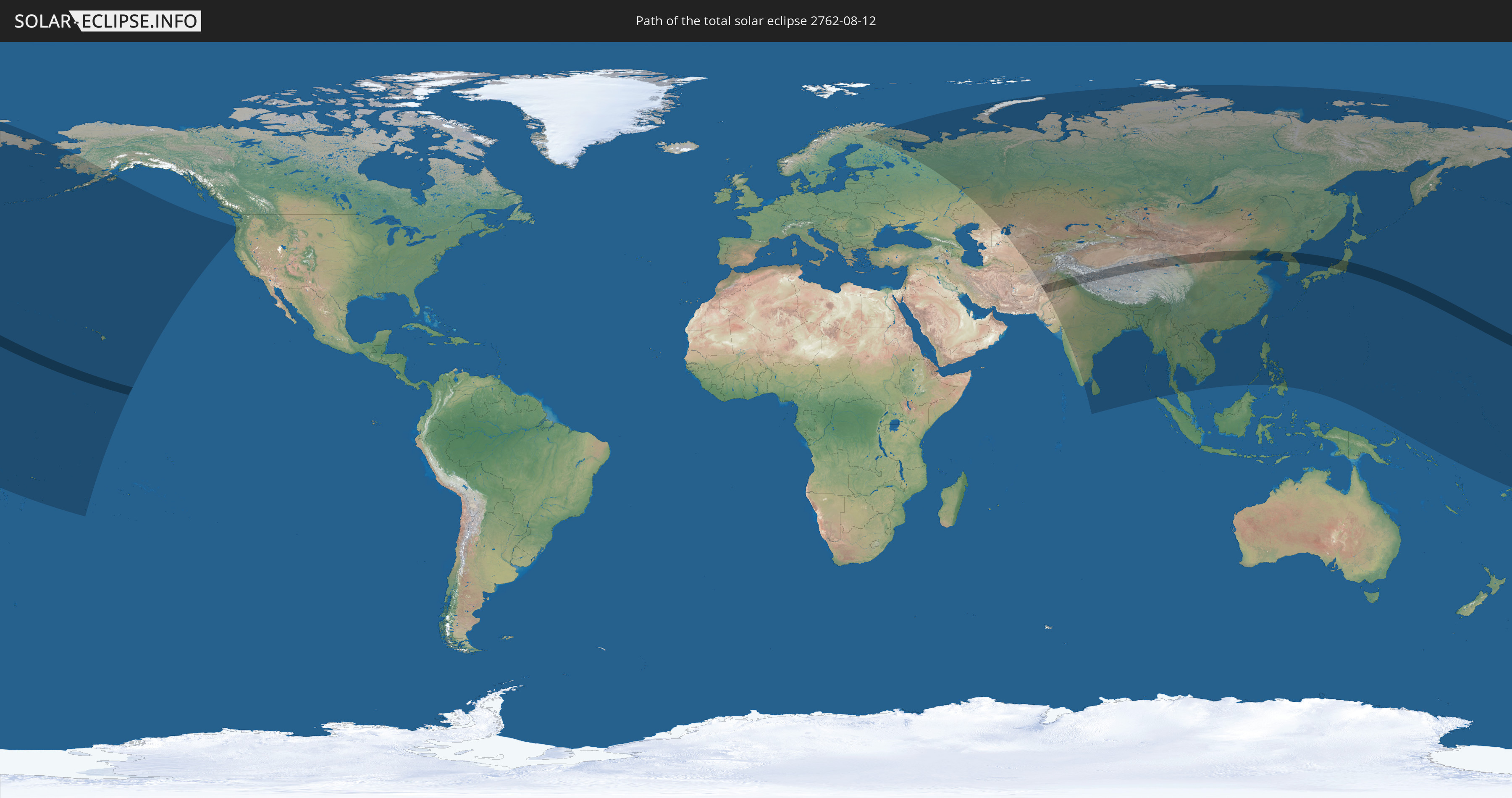
Die Sonnenfinsternis am 08/12/2762 kann man in 50 Ländern als partielle Sonnenfinsternis beobachten.
Der Finsternispfad verläuft durch 7 Länder. Nur in diesen Ländern ist sie als total Sonnenfinsternis zu sehen.
In den folgenden Ländern ist die Sonnenfinsternis total zu sehen
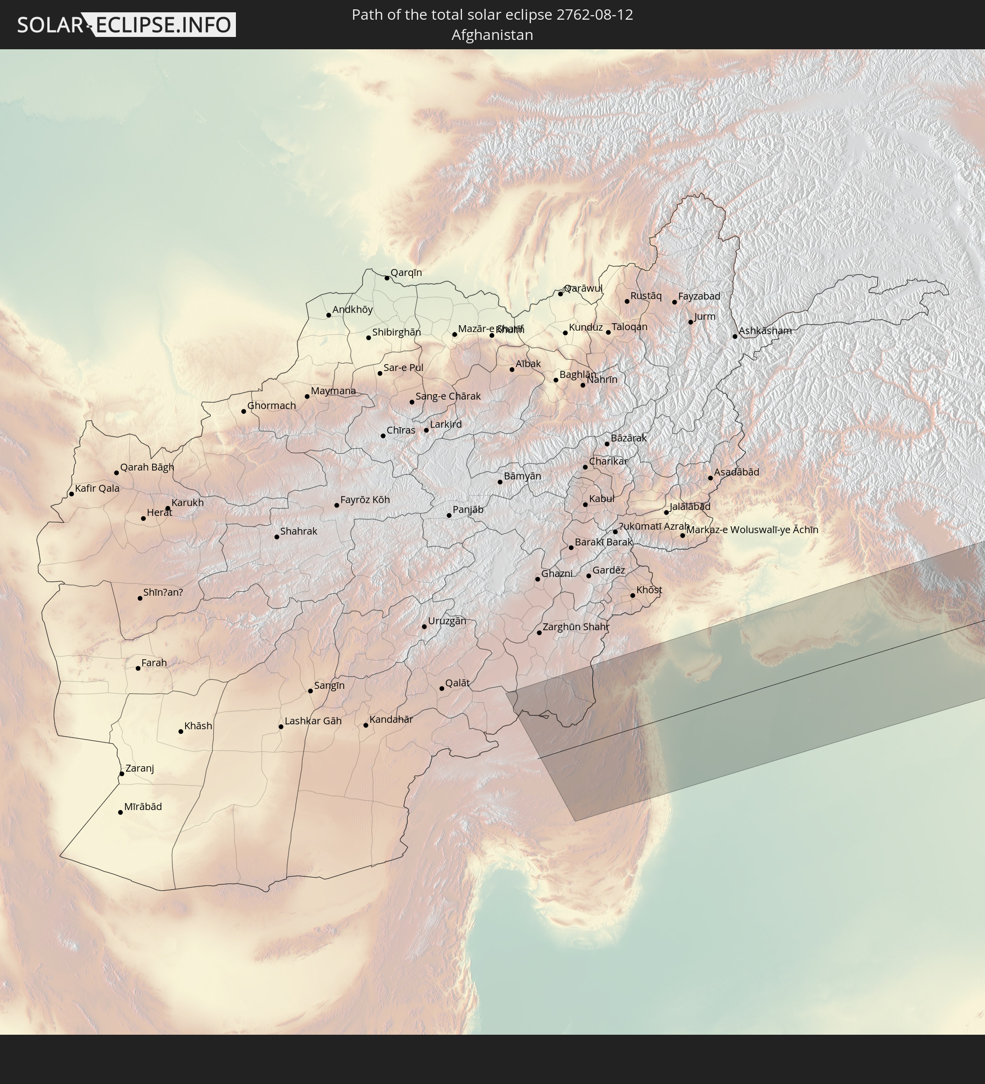 Afghanistan
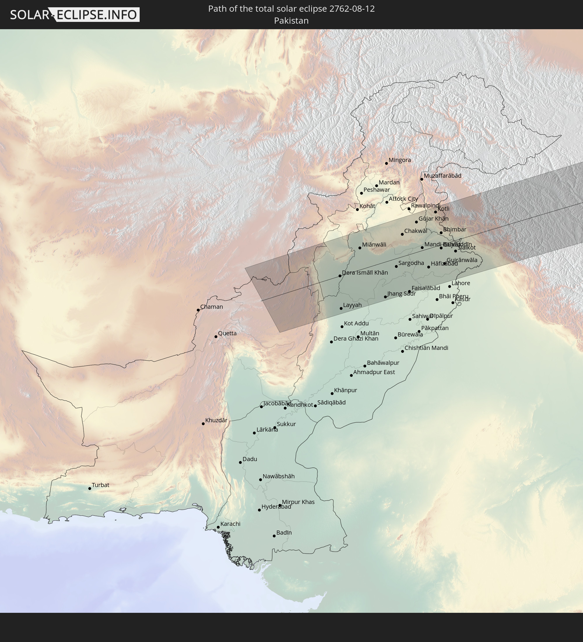 Pakistan
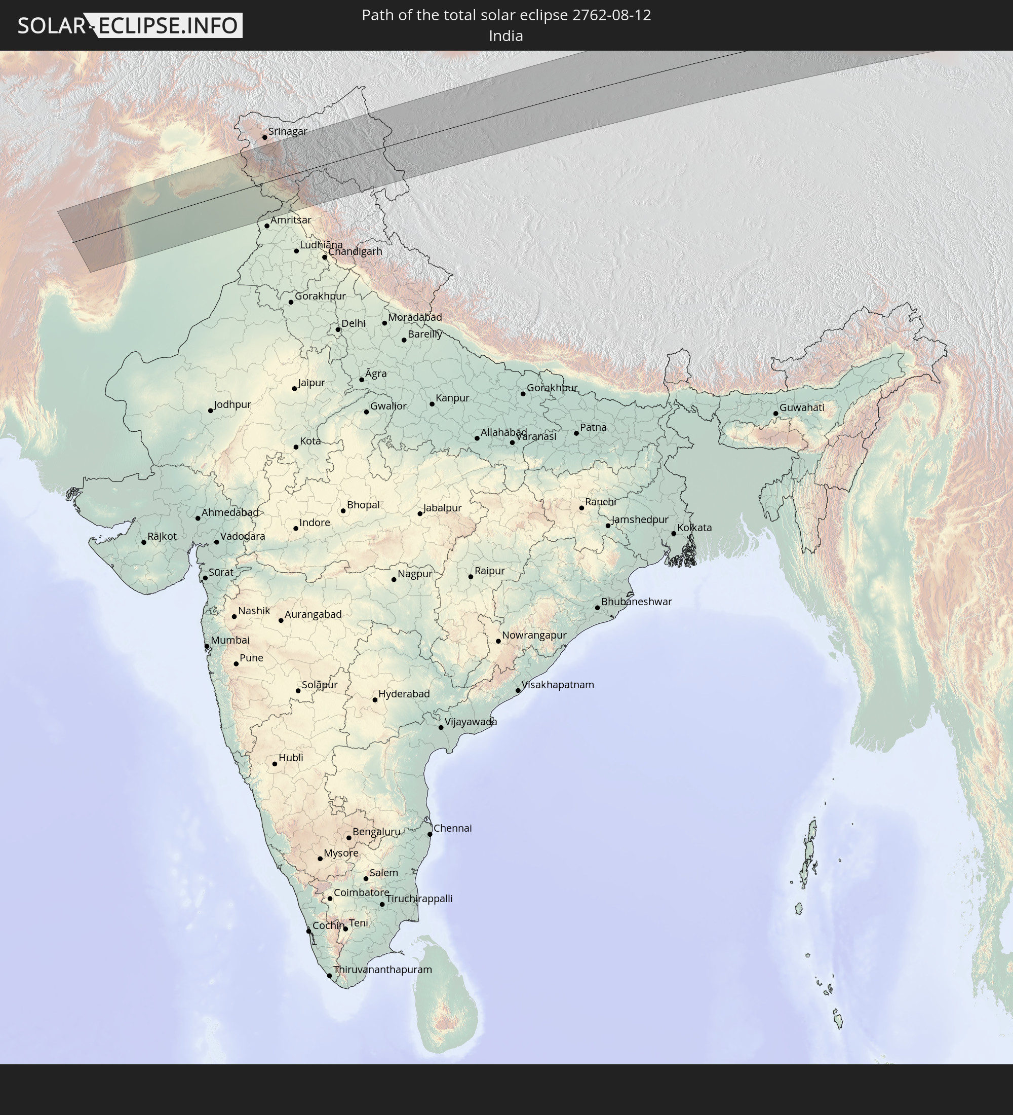 India
India
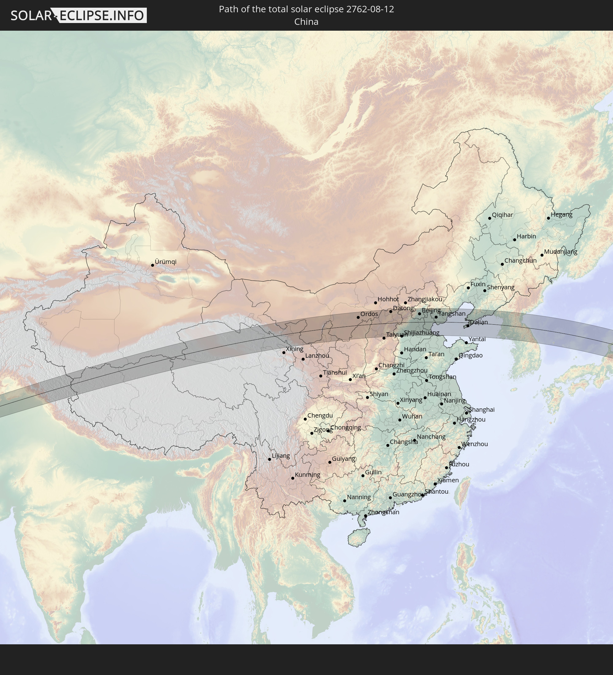 China
China
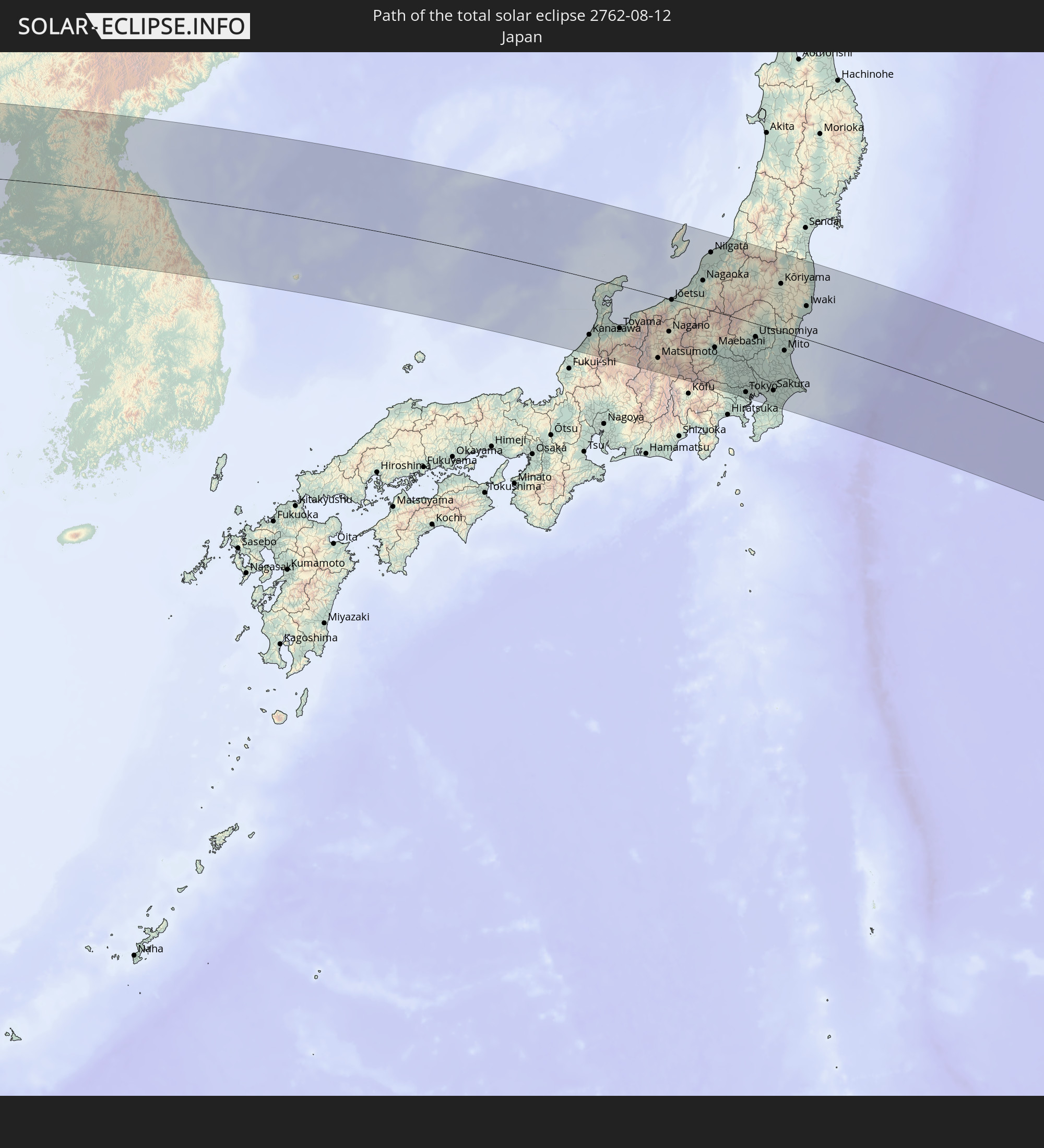 Japan
Japan
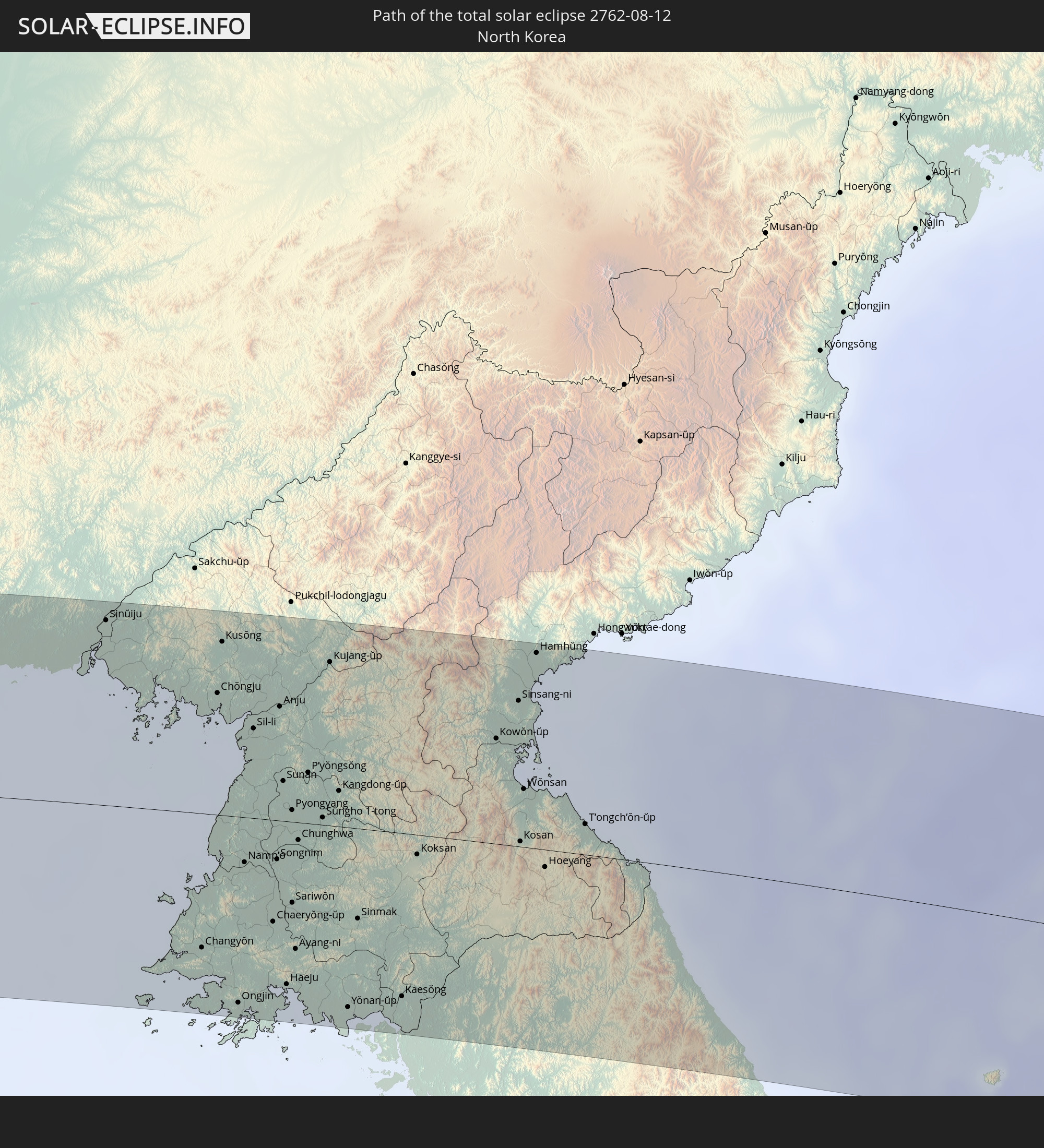 North Korea
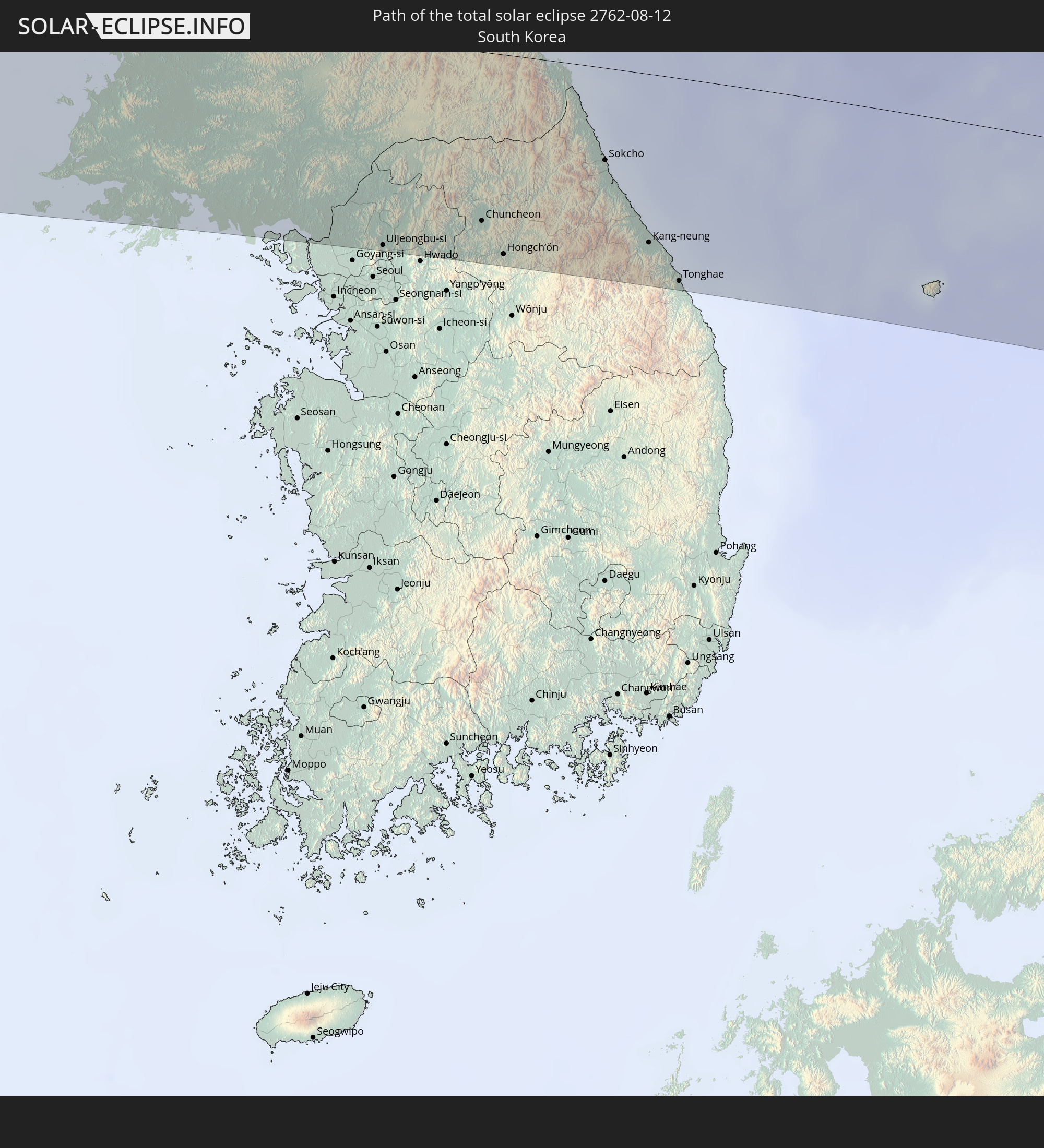 South Korea
In den folgenden Ländern ist die Sonnenfinsternis partiell zu sehen
 Russia
 Fiji
Fiji
 United States
 United States Minor Outlying Islands
 Wallis and Futuna
 Tonga
Tonga
 Kiribati
 Samoa
Samoa
 Tokelau
 American Samoa
 Niue
Niue
 Cook Islands
 Finland
 Kazakhstan
 Turkmenistan
 Uzbekistan
 Afghanistan
 Pakistan
 Tajikistan
 India
India
 Kyrgyzstan
 China
China
 Sri Lanka
 Nepal
Nepal
 Mongolia
 Bangladesh
 Bhutan
 Myanmar
 Indonesia
 Thailand
 Malaysia
 Laos
Laos
 Vietnam
 Cambodia
 Macau
Macau
 Hong Kong
 Taiwan
 Philippines
 Japan
Japan
 North Korea
 South Korea
 Palau
Palau
 Federated States of Micronesia
 Papua New Guinea
 Guam
Guam
 Northern Mariana Islands
 Solomon Islands
 Marshall Islands
 Nauru
Nauru
 Tuvalu
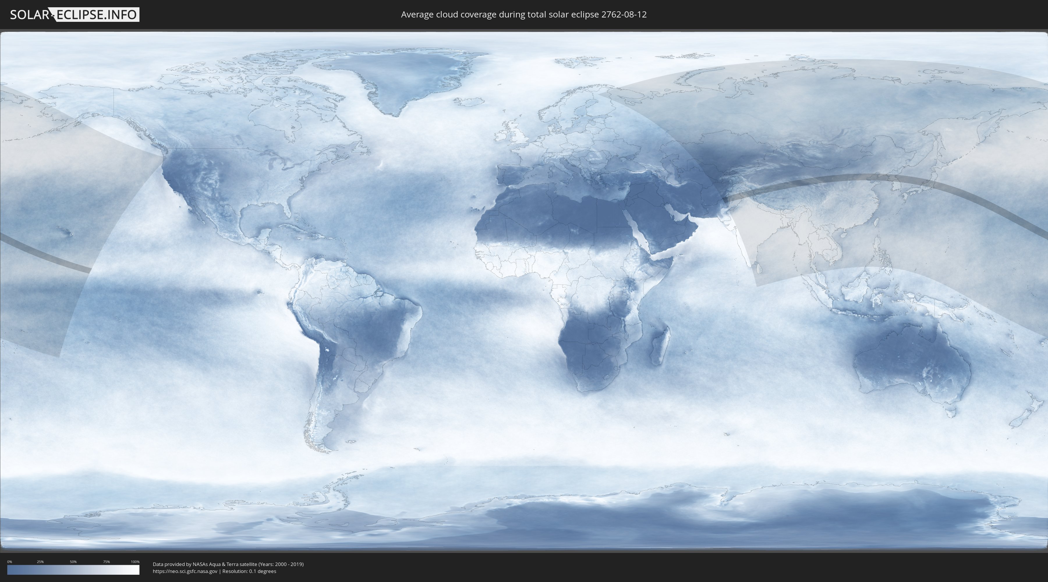
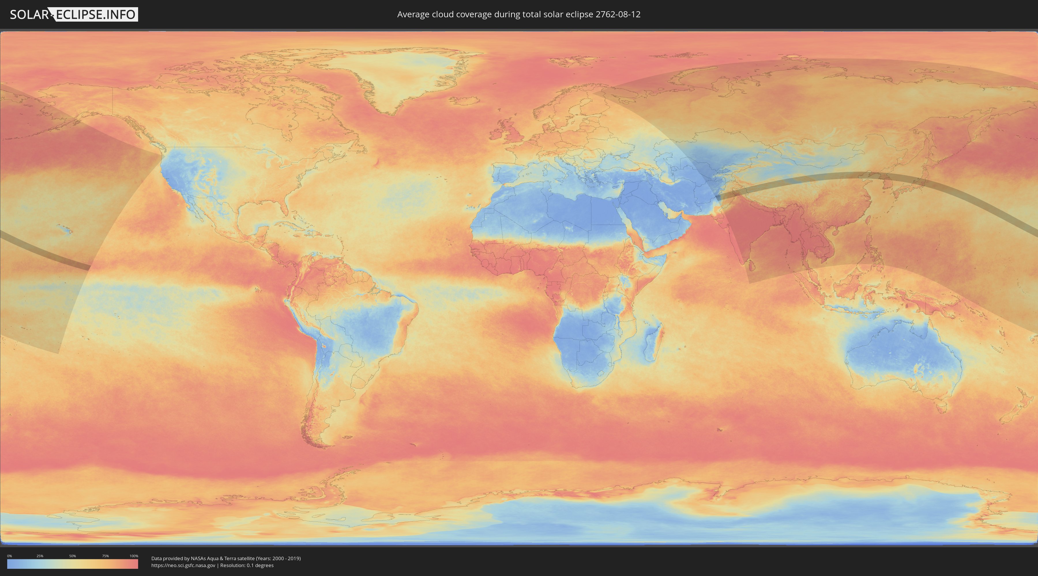
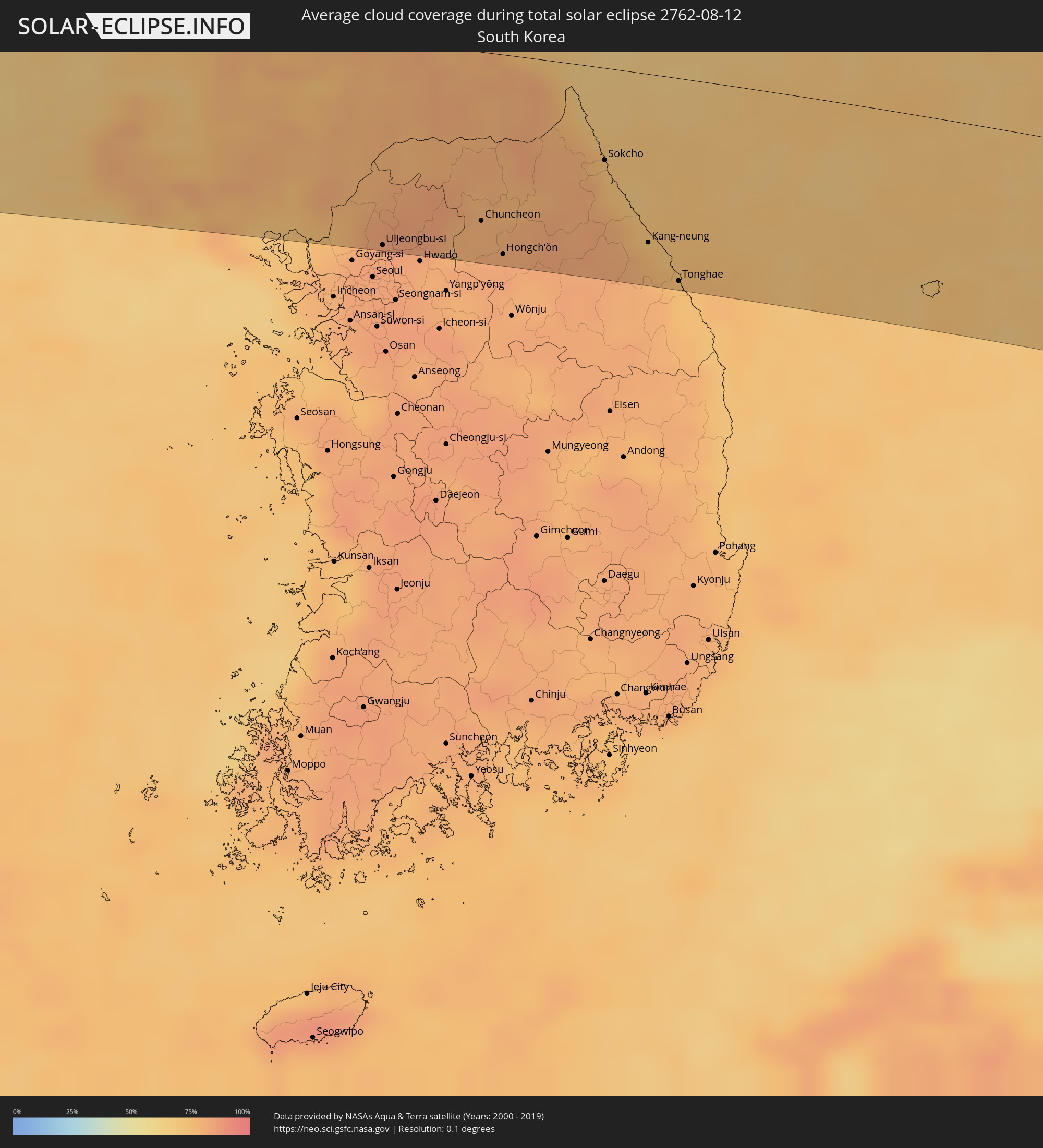
How will be the weather during the total solar eclipse on 08/12/2762?
Where is the best place to see the total solar eclipse of 08/12/2762?
The following maps show the average cloud coverage for the day of the total solar eclipse.
With the help of these maps, it is possible to find the place along the eclipse path, which has the best
chance of a cloudless sky.
Nevertheless, you should consider local circumstances and inform about the weather of your chosen
observation site.
The data is provided by NASAs satellites
AQUA and TERRA.
The cloud maps are averaged over a period of 19 years (2000 - 2019).
Detailed country maps
 Afghanistan
 Pakistan
 India
India
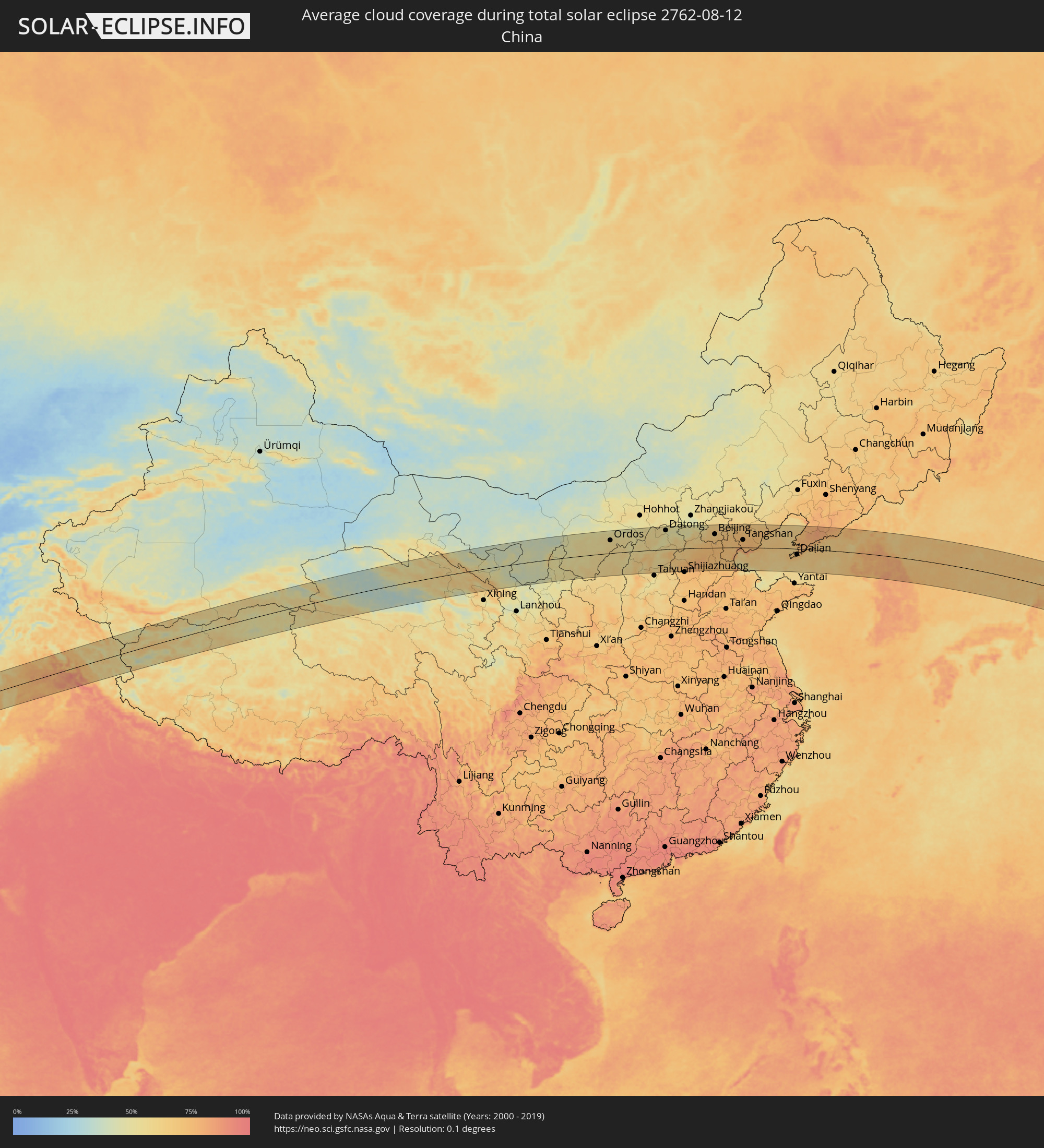 China
China
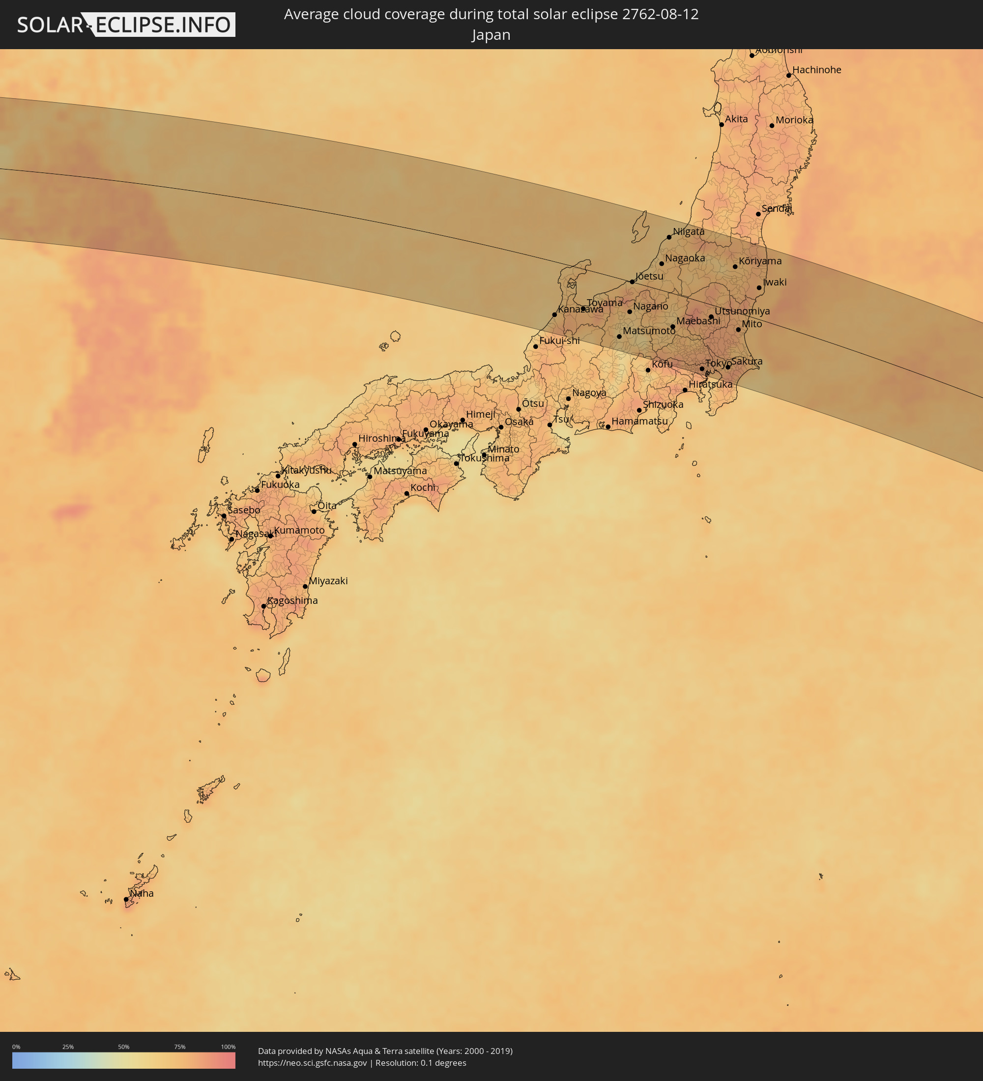 Japan
Japan
 North Korea
 South Korea
Cities inside the path of the eclipse
The following table shows all locations with a population of more than 5,000 inside the eclipse path. Cities which have more than 100,000 inhabitants are marked bold. A click at the locations opens a detailed map.
| City | Type | Eclipse duration | Local time of max. eclipse | Distance to central line | Ø Cloud coverage |
|
Zhob, Balochistān
|
total | - | 05:55:55 UTC+05:00 | 12 km | 16% |
|
Dera Ismāīl Khān, Khyber Pakhtunkhwa
|
total | - | 05:56:04 UTC+05:00 | 1 km | 67% |
|
Layyah, Punjab
|
total | - | 05:55:25 UTC+05:00 | 95 km | 70% |
|
Bhakkar, Punjab
|
total | - | 05:55:53 UTC+05:00 | 28 km | 69% |
|
Miānwāli, Punjab
|
total | - | 05:56:33 UTC+05:00 | 60 km | 62% |
|
Jhang Sadr, Punjab
|
total | - | 05:55:29 UTC+05:00 | 101 km | 74% |
|
Khushāb, Punjab
|
total | - | 05:56:15 UTC+05:00 | 8 km | 72% |
|
Sargodha, Punjab
|
total | - | 05:56:04 UTC+05:00 | 24 km | 74% |
|
Chakwāl, Punjab
|
total | - | 05:56:42 UTC+05:00 | 62 km | 77% |
|
Bhalwāl, Punjab
|
total | - | 05:56:11 UTC+05:00 | 10 km | 76% |
|
Chiniot, Punjab
|
total | - | 05:55:46 UTC+05:00 | 71 km | 74% |
|
Faisalābād, Punjab
|
total | - | 05:55:32 UTC+05:00 | 106 km | 74% |
|
Gūjar Khān, Punjab
|
total | - | 05:56:56 UTC+05:00 | 84 km | 77% |
|
Sangla Hill, Punjab
|
total | - | 05:55:44 UTC+05:00 | 82 km | 78% |
|
Mandi Bahāuddīn, Punjab
|
total | - | 05:56:23 UTC+05:00 | 7 km | 79% |
|
Shahkot, Punjab
|
total | - | 05:55:37 UTC+05:00 | 101 km | 80% |
|
Hāfizābād, Punjab
|
total | - | 05:55:59 UTC+05:00 | 53 km | 74% |
|
Jhelum, Punjab
|
total | - | 05:56:39 UTC+05:00 | 38 km | 77% |
|
Chūhar Kāna, Punjab
|
total | - | 05:55:44 UTC+05:00 | 90 km | 79% |
|
Khāriān, Punjab
|
total | - | 05:56:33 UTC+05:00 | 21 km | 83% |
|
Kotli, Azad Kashmir
|
total | - | 05:57:06 UTC+05:00 | 95 km | 69% |
|
Sheikhupura, Punjab
|
total | - | 05:55:42 UTC+05:00 | 99 km | 77% |
|
Bhimbar, Azad Kashmir
|
total | - | 05:56:40 UTC+05:00 | 32 km | 79% |
|
Gujrāt, Punjab
|
total | - | 05:56:21 UTC+05:00 | 10 km | 79% |
|
Gujrānwāla, Punjab
|
total | - | 05:56:02 UTC+05:00 | 57 km | 77% |
|
Kamoke, Punjab
|
total | - | 05:55:53 UTC+05:00 | 78 km | 75% |
|
Murīdke, Punjab
|
total | - | 05:55:45 UTC+05:00 | 97 km | 78% |
|
Rajaori, Kashmir
|
total | - | 06:26:58 UTC+05:30 | 69 km | 71% |
|
Daska, Punjab
|
total | - | 05:56:09 UTC+05:00 | 44 km | 78% |
|
Sambriāl, Punjab
|
total | - | 05:56:16 UTC+05:00 | 28 km | 78% |
|
Nawānshahr, Kashmir
|
total | - | 06:26:29 UTC+05:30 | 2 km | 77% |
|
Sialkot, Punjab
|
total | - | 05:56:16 UTC+05:00 | 31 km | 80% |
|
Hadāli, Punjab
|
total | - | 05:56:23 UTC+05:00 | 16 km | 83% |
|
Pasrūr, Punjab
|
total | - | 05:56:05 UTC+05:00 | 59 km | 84% |
|
Akhnūr, Kashmir
|
total | - | 06:26:33 UTC+05:30 | 3 km | 77% |
|
Ajnāla, Punjab
|
total | - | 06:25:46 UTC+05:30 | 107 km | 77% |
|
Tsrār Sharīf, Kashmir
|
total | - | 06:27:21 UTC+05:30 | 108 km | 56% |
|
Norīa, Kashmir
|
total | - | 06:26:17 UTC+05:30 | 35 km | 85% |
|
Riāsi, Kashmir
|
total | - | 06:26:43 UTC+05:30 | 23 km | 77% |
|
Shupīyan, Kashmir
|
total | - | 06:27:14 UTC+05:30 | 91 km | 69% |
|
Bishnāh, Kashmir
|
total | - | 06:26:21 UTC+05:30 | 27 km | 81% |
|
Jammu, Kashmir
|
total | - | 06:26:27 UTC+05:30 | 14 km | 81% |
|
Nārowāl, Punjab
|
total | - | 05:55:57 UTC+05:00 | 83 km | 79% |
|
Pulwama, Kashmir
|
total | - | 06:27:22 UTC+05:30 | 106 km | 52% |
|
Katra, Kashmir
|
total | - | 06:26:39 UTC+05:30 | 11 km | 82% |
|
Fatehgarh Chūriān, Punjab
|
total | - | 06:25:46 UTC+05:30 | 110 km | 74% |
|
Kulgam, Kashmir
|
total | - | 06:27:10 UTC+05:30 | 78 km | 70% |
|
Trāl, Kashmir
|
total | - | 06:27:24 UTC+05:30 | 106 km | 52% |
|
Sāmba, Kashmir
|
total | - | 06:26:18 UTC+05:30 | 40 km | 83% |
|
Udhampur, Kashmir
|
total | - | 06:26:36 UTC+05:30 | 2 km | 81% |
|
Kalanaur, Punjab
|
total | - | 06:25:53 UTC+05:30 | 99 km | 77% |
|
Anantnag, Kashmir
|
total | - | 06:27:14 UTC+05:30 | 84 km | 52% |
|
Shakargarh, Punjab
|
total | - | 05:56:04 UTC+05:00 | 73 km | 88% |
|
Hirānagar, Kashmir
|
total | - | 06:26:13 UTC+05:30 | 55 km | 85% |
|
Rāmnagar, Kashmir
|
total | - | 06:26:30 UTC+05:30 | 19 km | 85% |
|
Dhāriwāl, Punjab
|
total | - | 06:25:50 UTC+05:30 | 110 km | 77% |
|
Parol, Kashmir
|
total | - | 06:26:08 UTC+05:30 | 71 km | 82% |
|
Dīnānagar, Punjab
|
total | - | 06:25:58 UTC+05:30 | 95 km | 79% |
|
Kathua, Kashmir
|
total | - | 06:26:09 UTC+05:30 | 71 km | 81% |
|
Doda, Kashmir
|
total | - | 06:26:46 UTC+05:30 | 11 km | 76% |
|
Pathānkot, Punjab
|
total | - | 06:26:05 UTC+05:30 | 85 km | 83% |
|
Bhadarwāh, Kashmir
|
total | - | 06:26:38 UTC+05:30 | 11 km | 82% |
|
Kishtwār, Kashmir
|
total | - | 06:26:54 UTC+05:30 | 23 km | 69% |
|
Chamba, Himachal Pradesh
|
total | - | 06:26:18 UTC+05:30 | 68 km | 83% |
|
Dharmsāla, Himachal Pradesh
|
total | - | 06:26:02 UTC+05:30 | 109 km | 90% |
|
Padam, Kashmir
|
total | - | 06:27:03 UTC+05:30 | 9 km | 51% |
|
Kyelang, Himachal Pradesh
|
total | - | 06:26:20 UTC+05:30 | 90 km | 69% |
|
Leh, Kashmir
|
total | - | 06:27:39 UTC+05:30 | 66 km | 45% |
|
Jinchang, Gansu
|
total | - | 09:12:31 UTC+08:00 | 27 km | 46% |
|
Wuwei, Gansu
|
total | - | 09:12:25 UTC+08:00 | 42 km | 50% |
|
Yinchuan, Ningsia Hui Autonomous Region
|
total | - | 09:16:24 UTC+08:00 | 25 km | 51% |
|
Dawukou, Ningsia Hui Autonomous Region
|
total | - | 09:16:59 UTC+08:00 | 37 km | 47% |
|
Wuda, Inner Mongolia
|
total | - | 09:17:42 UTC+08:00 | 85 km | 43% |
|
Shizuishan, Ningsia Hui Autonomous Region
|
total | - | 09:17:32 UTC+08:00 | 55 km | 47% |
|
Wuhai, Inner Mongolia
|
total | - | 09:17:57 UTC+08:00 | 104 km | 45% |
|
Ordos, Inner Mongolia
|
total | - | 09:21:08 UTC+08:00 | 70 km | 55% |
|
Dongsheng, Inner Mongolia
|
total | - | 09:21:31 UTC+08:00 | 91 km | 54% |
|
Xinzhou, Shanxi
|
total | - | 09:23:54 UTC+08:00 | 82 km | 55% |
|
Datong, Shanxi
|
total | - | 09:25:46 UTC+08:00 | 103 km | 49% |
|
Dingzhou, Hebei
|
total | - | 09:27:01 UTC+08:00 | 79 km | 77% |
|
Baoding, Hebei
|
total | - | 09:27:54 UTC+08:00 | 43 km | 75% |
|
Fangshan, Beijing
|
total | - | 09:29:06 UTC+08:00 | 49 km | 69% |
|
Mentougou, Beijing
|
total | - | 09:29:24 UTC+08:00 | 77 km | 68% |
|
Renqiu, Hebei
|
total | - | 09:28:40 UTC+08:00 | 61 km | 73% |
|
Daxing, Beijing
|
total | - | 09:29:36 UTC+08:00 | 55 km | 69% |
|
Beijing, Beijing
|
total | - | 09:29:48 UTC+08:00 | 73 km | 65% |
|
Shunyi, Beijing
|
total | - | 09:30:16 UTC+08:00 | 97 km | 66% |
|
Tongzhou, Beijing
|
total | - | 09:30:10 UTC+08:00 | 72 km | 68% |
|
Langfang, Hebei
|
total | - | 09:29:59 UTC+08:00 | 29 km | 71% |
|
Cangzhou, Hebei
|
total | - | 09:29:34 UTC+08:00 | 104 km | 71% |
|
Tianjin, Tianjin
|
total | - | 09:30:28 UTC+08:00 | 13 km | 71% |
|
Tanggu, Tianjin
|
total | - | 09:31:06 UTC+08:00 | 26 km | 78% |
|
Hangu, Tianjin
|
total | - | 09:31:26 UTC+08:00 | 1 km | 80% |
|
Tangshan, Hebei
|
total | - | 09:32:13 UTC+08:00 | 42 km | 74% |
|
Linxi, Hebei
|
total | - | 09:32:39 UTC+08:00 | 51 km | 74% |
|
Qinhuangdao, Hebei
|
total | - | 09:34:28 UTC+08:00 | 76 km | 69% |
|
Shanhaiguan, Hebei
|
total | - | 09:34:44 UTC+08:00 | 84 km | 70% |
|
Dalian, Liaoning
|
total | - | 09:37:11 UTC+08:00 | 32 km | 72% |
|
Jinzhou, Liaoning
|
total | - | 09:37:26 UTC+08:00 | 10 km | 72% |
|
Pulandian, Liaoning
|
total | - | 09:37:57 UTC+08:00 | 24 km | 78% |
|
Wafangdian, Liaoning
|
total | - | 09:38:06 UTC+08:00 | 49 km | 78% |
|
Dandong, Liaoning
|
total | - | 09:42:11 UTC+08:00 | 119 km | 69% |
|
Sinŭiju, P'yŏngan-bukto
|
total | - | 10:42:11 UTC+09:00 | 115 km | 69% |
|
Changyŏn, Hwanghae-namdo
|
total | - | 10:42:54 UTC+09:00 | 85 km | 78% |
|
Chŏngju, P'yŏngan-bukto
|
total | - | 10:43:26 UTC+09:00 | 76 km | 68% |
|
Kusŏng, P'yŏngan-bukto
|
total | - | 10:43:34 UTC+09:00 | 108 km | 71% |
|
Ongjin, Hwanghae-namdo
|
total | - | 10:43:18 UTC+09:00 | 118 km | 69% |
|
Namp’o, P'yŏngan-namdo
|
total | - | 10:43:33 UTC+09:00 | 28 km | 67% |
|
Sil-li, P'yŏngan-namdo
|
total | - | 10:43:50 UTC+09:00 | 56 km | 67% |
|
Anak, Hwanghae-bukto
|
total | - | 10:43:39 UTC+09:00 | 53 km | 72% |
|
Sinanju, P'yŏngan-namdo
|
total | - | 10:44:06 UTC+09:00 | 69 km | 67% |
|
Chaeryŏng-ŭp, Hwanghae-namdo
|
total | - | 10:43:51 UTC+09:00 | 64 km | 69% |
|
Songnim, Hwanghae-bukto
|
total | - | 10:43:58 UTC+09:00 | 24 km | 70% |
|
Anju, P'yŏngan-namdo
|
total | - | 10:44:12 UTC+09:00 | 71 km | 70% |
|
Sunan, Pyongyang
|
total | - | 10:44:09 UTC+09:00 | 25 km | 77% |
|
Haeju, Hwanghae-namdo
|
total | - | 10:43:57 UTC+09:00 | 103 km | 73% |
|
Pyongyang, Pyongyang
|
total | - | 10:44:13 UTC+09:00 | 7 km | 78% |
|
Sariwŏn, Hwanghae-bukto
|
total | - | 10:44:07 UTC+09:00 | 51 km | 73% |
|
Hwangju-ŭp, Hwanghae-bukto
|
total | - | 10:44:11 UTC+09:00 | 33 km | 74% |
|
Ayang-ni, Hwanghae-namdo
|
total | - | 10:44:07 UTC+09:00 | 80 km | 77% |
|
Hŭkkyo-ri, Hwanghae-bukto
|
total | - | 10:44:14 UTC+09:00 | 18 km | 74% |
|
Chunghwa, Pyongyang
|
total | - | 10:44:16 UTC+09:00 | 11 km | 74% |
|
P’yŏngsŏng, P'yŏngan-namdo
|
total | - | 10:44:28 UTC+09:00 | 32 km | 75% |
|
Sŭngho 1-tong, Pyongyang
|
total | - | 10:44:36 UTC+09:00 | 5 km | 77% |
|
Kujang-ŭp, P'yŏngan-bukto
|
total | - | 10:44:53 UTC+09:00 | 102 km | 67% |
|
Kangdong-ŭp, Pyongyang
|
total | - | 10:44:51 UTC+09:00 | 22 km | 79% |
|
Yŏnan-ŭp, Hwanghae-namdo
|
total | - | 10:44:44 UTC+09:00 | 114 km | 69% |
|
Sinmak, Hwanghae-bukto
|
total | - | 10:44:57 UTC+09:00 | 57 km | 78% |
|
Kaesŏng, Hwanghae-namdo
|
total | - | 10:45:28 UTC+09:00 | 103 km | 78% |
|
Munsan, Gyeonggi-do
|
total | - | 10:45:52 UTC+09:00 | 113 km | 77% |
|
Uijeongbu-si, Gyeonggi-do
|
total | - | 10:46:20 UTC+09:00 | 124 km | 83% |
|
Yangju, Gyeonggi-do
|
total | - | 10:46:22 UTC+09:00 | 113 km | 84% |
|
Kowŏn-ŭp, Hamgyŏng-namdo
|
total | - | 10:46:55 UTC+09:00 | 66 km | 72% |
|
Kosan, Kangwŏn-do
|
total | - | 10:47:09 UTC+09:00 | 3 km | 78% |
|
Wŏnsan, Kangwŏn-do
|
total | - | 10:47:14 UTC+09:00 | 36 km | 69% |
|
Gapyeong, Gyeonggi-do
|
total | - | 10:47:12 UTC+09:00 | 109 km | 77% |
|
Anbyŏn-ŭp, Kangwŏn-do
|
total | - | 10:47:22 UTC+09:00 | 25 km | 73% |
|
Hamhŭng, Hamgyŏng-namdo
|
total | - | 10:47:31 UTC+09:00 | 122 km | 59% |
|
Hoeyang, Kangwŏn-do
|
total | - | 10:47:28 UTC+09:00 | 11 km | 79% |
|
Hwacheon, Gangwon-do
|
total | - | 10:47:36 UTC+09:00 | 76 km | 77% |
|
Chuncheon, Gangwon-do
|
total | - | 10:47:37 UTC+09:00 | 102 km | 78% |
|
Hongch’ŏn, Gangwon-do
|
total | - | 10:47:53 UTC+09:00 | 120 km | 82% |
|
T’ongch’ŏn-ŭp, Kangwŏn-do
|
total | - | 10:48:01 UTC+09:00 | 19 km | 69% |
|
Yanggu, Gangwon-do
|
total | - | 10:48:07 UTC+09:00 | 73 km | 77% |
|
Kosong, Gangwon-do
|
total | - | 10:49:02 UTC+09:00 | 38 km | 71% |
|
Sokcho, Gangwon-do
|
total | - | 10:49:15 UTC+09:00 | 55 km | 73% |
|
Kang-neung, Gangwon-do
|
total | - | 10:49:48 UTC+09:00 | 101 km | 74% |
|
Tonghae, Gangwon-do
|
total | - | 10:50:11 UTC+09:00 | 122 km | 73% |
|
Komatsu, Ishikawa
|
total | - | 11:05:12 UTC+09:00 | 121 km | 76% |
|
Kanazawa, Ishikawa
|
total | - | 11:05:29 UTC+09:00 | 96 km | 72% |
|
Takaoka, Toyama
|
total | - | 11:06:15 UTC+09:00 | 71 km | 75% |
|
Toyama, Toyama
|
total | - | 11:06:41 UTC+09:00 | 72 km | 77% |
|
Matsumoto, Nagano
|
total | - | 11:08:29 UTC+09:00 | 105 km | 62% |
|
Nagano, Nagano
|
total | - | 11:08:44 UTC+09:00 | 55 km | 66% |
|
Jōetsu, Niigata
|
total | - | 11:08:37 UTC+09:00 | 1 km | 79% |
|
Ueda, Nagano
|
total | - | 11:09:04 UTC+09:00 | 80 km | 58% |
|
Kashiwazaki, Niigata
|
total | - | 11:09:10 UTC+09:00 | 30 km | 67% |
|
Nagaoka, Niigata
|
total | - | 11:09:45 UTC+09:00 | 46 km | 73% |
|
Niigata, Niigata
|
total | - | 11:09:51 UTC+09:00 | 97 km | 70% |
|
Maebashi, Gunma
|
total | - | 11:10:46 UTC+09:00 | 60 km | 73% |
|
Ōme, Tokyo
|
total | - | 11:11:26 UTC+09:00 | 122 km | 83% |
|
Sakado, Saitama
|
total | - | 11:11:39 UTC+09:00 | 100 km | 79% |
|
Kumagaya, Saitama
|
total | - | 11:11:33 UTC+09:00 | 81 km | 78% |
|
Hino, Tokyo
|
total | - | 11:11:50 UTC+09:00 | 130 km | 77% |
|
Ashikaga, Tochigi
|
total | - | 11:11:34 UTC+09:00 | 58 km | 71% |
|
Tokorozawa, Saitama
|
total | - | 11:11:55 UTC+09:00 | 115 km | 80% |
|
Saitama, Saitama
|
total | - | 11:12:15 UTC+09:00 | 98 km | 82% |
|
Tokyo, Tokyo
|
total | - | 11:12:27 UTC+09:00 | 121 km | 81% |
|
Sōka, Saitama
|
total | - | 11:12:36 UTC+09:00 | 102 km | 78% |
|
Oyama, Tochigi
|
total | - | 11:12:20 UTC+09:00 | 53 km | 82% |
|
Utsunomiya, Tochigi
|
total | - | 11:12:22 UTC+09:00 | 22 km | 81% |
|
Kashiwa, Chiba
|
total | - | 11:12:58 UTC+09:00 | 95 km | 79% |
|
Honchō, Chiba
|
total | - | 11:13:05 UTC+09:00 | 112 km | 71% |
|
Tsukuba, Ibaraki
|
total | - | 11:13:02 UTC+09:00 | 56 km | 83% |
|
Yonezawa, Yamagata
|
total | - | 11:12:06 UTC+09:00 | 127 km | 76% |
|
Chiba, Chiba
|
total | - | 11:13:25 UTC+09:00 | 119 km | 78% |
|
Sakura, Chiba
|
total | - | 11:13:36 UTC+09:00 | 104 km | 83% |
|
Kōriyama, Fukushima
|
total | - | 11:12:56 UTC+09:00 | 79 km | 73% |
|
Mito, Ibaraki
|
total | - | 11:13:41 UTC+09:00 | 31 km | 76% |
|
Fukushima, Fukushima
|
total | - | 11:12:55 UTC+09:00 | 119 km | 76% |
|
Hitachi, Ibaraki
|
total | - | 11:13:57 UTC+09:00 | 1 km | 74% |
|
Iwaki, Fukushima
|
total | - | 11:14:11 UTC+09:00 | 55 km | 75% |