Total solar eclipse of 07/22/2772
| Day of week: | Saturday |
| Maximum duration of eclipse: | 02m27s |
| Maximum width of eclipse path: | 95 km |
| Saros cycle: | 158 |
| Coverage: | 100% |
| Magnitude: | 1.0272 |
| Gamma: | 0.2259 |
Wo kann man die Sonnenfinsternis vom 07/22/2772 sehen?
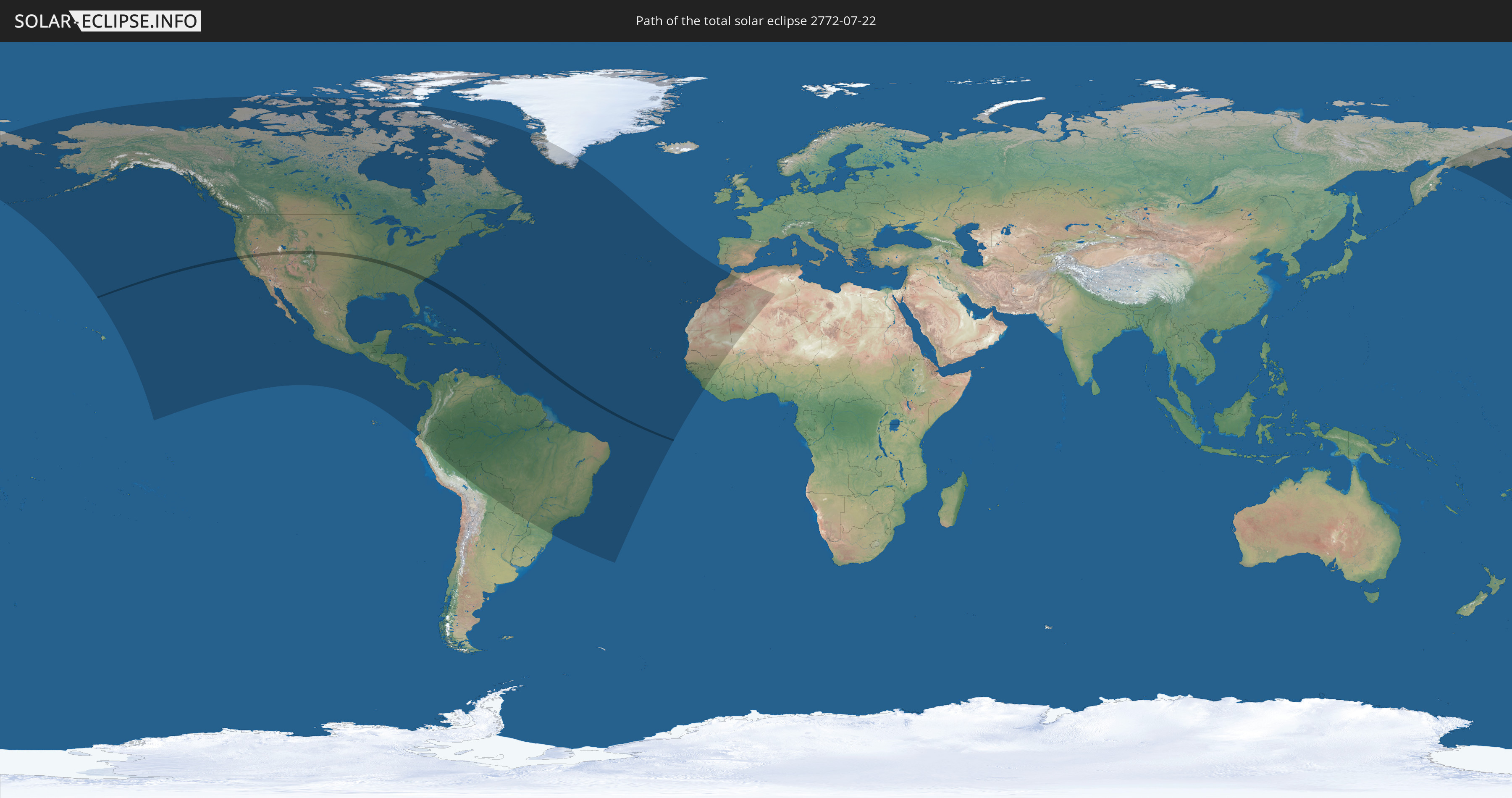
Die Sonnenfinsternis am 07/22/2772 kann man in 62 Ländern als partielle Sonnenfinsternis beobachten.
Der Finsternispfad verläuft durch ein Land. Nur in diesem Land ist sie als total Sonnenfinsternis zu sehen.
In den folgenden Ländern ist die Sonnenfinsternis total zu sehen
 United States
In den folgenden Ländern ist die Sonnenfinsternis partiell zu sehen
 Russia
 United States
 United States Minor Outlying Islands
 Canada
 Mexico
 Greenland
 Guatemala
 Ecuador
 El Salvador
 Honduras
 Belize
 Nicaragua
 Costa Rica
 Cuba
Cuba
 Panama
 Colombia
 Cayman Islands
 Peru
Peru
 The Bahamas
 Jamaica
 Haiti
Haiti
 Brazil
 Venezuela
 Turks and Caicos Islands
 Dominican Republic
 Aruba
Aruba
 Bolivia
 Puerto Rico
 United States Virgin Islands
 Bermuda
 British Virgin Islands
 Anguilla
 Collectivity of Saint Martin
 Saint Barthélemy
 Saint Kitts and Nevis
 Paraguay
 Antigua and Barbuda
 Montserrat
 Trinidad and Tobago
 Guadeloupe
 Grenada
 Dominica
 Saint Vincent and the Grenadines
 Guyana
 Martinique
 Saint Lucia
 Barbados
 Suriname
 Saint Pierre and Miquelon
 French Guiana
 Portugal
 Cabo Verde
 Spain
Spain
 Senegal
 Mauritania
 The Gambia
 Guinea-Bissau
 Guinea
 Sierra Leone
 Morocco
 Mali
Mali
 Algeria
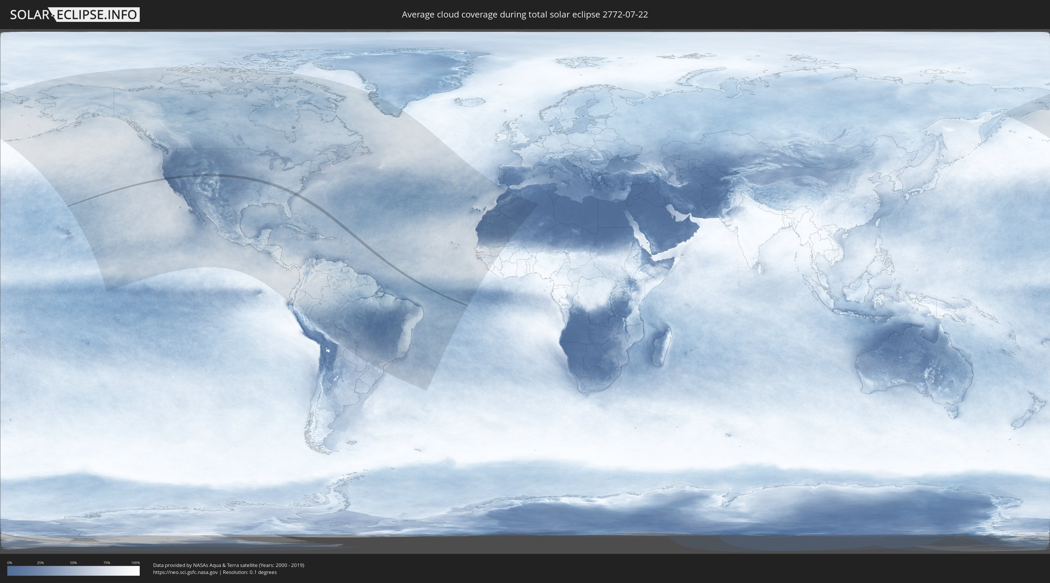
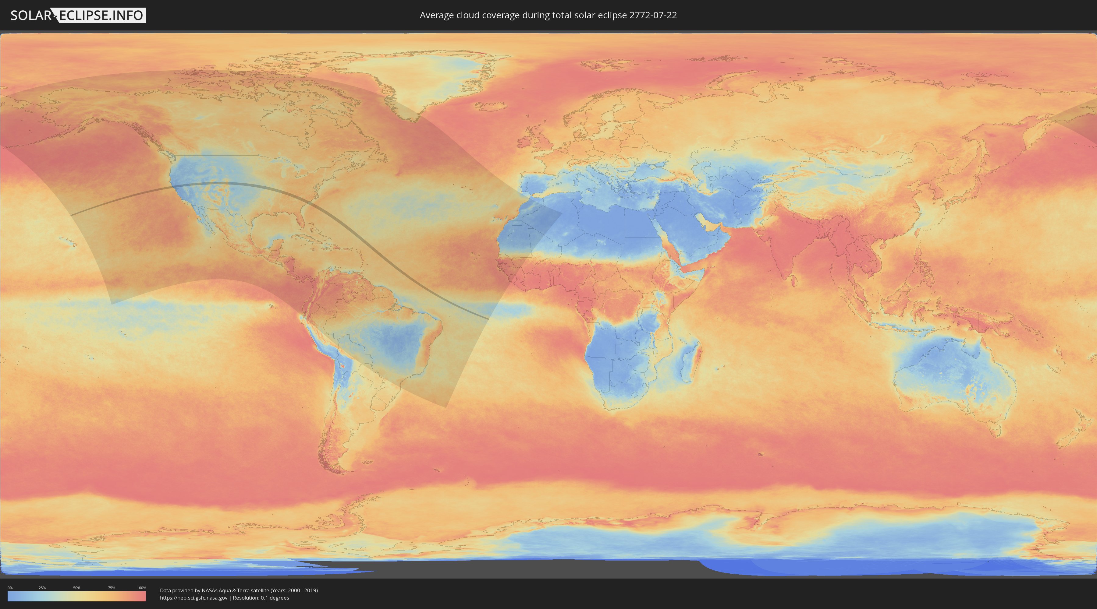
How will be the weather during the total solar eclipse on 07/22/2772?
Where is the best place to see the total solar eclipse of 07/22/2772?
The following maps show the average cloud coverage for the day of the total solar eclipse.
With the help of these maps, it is possible to find the place along the eclipse path, which has the best
chance of a cloudless sky.
Nevertheless, you should consider local circumstances and inform about the weather of your chosen
observation site.
The data is provided by NASAs satellites
AQUA and TERRA.
The cloud maps are averaged over a period of 19 years (2000 - 2019).
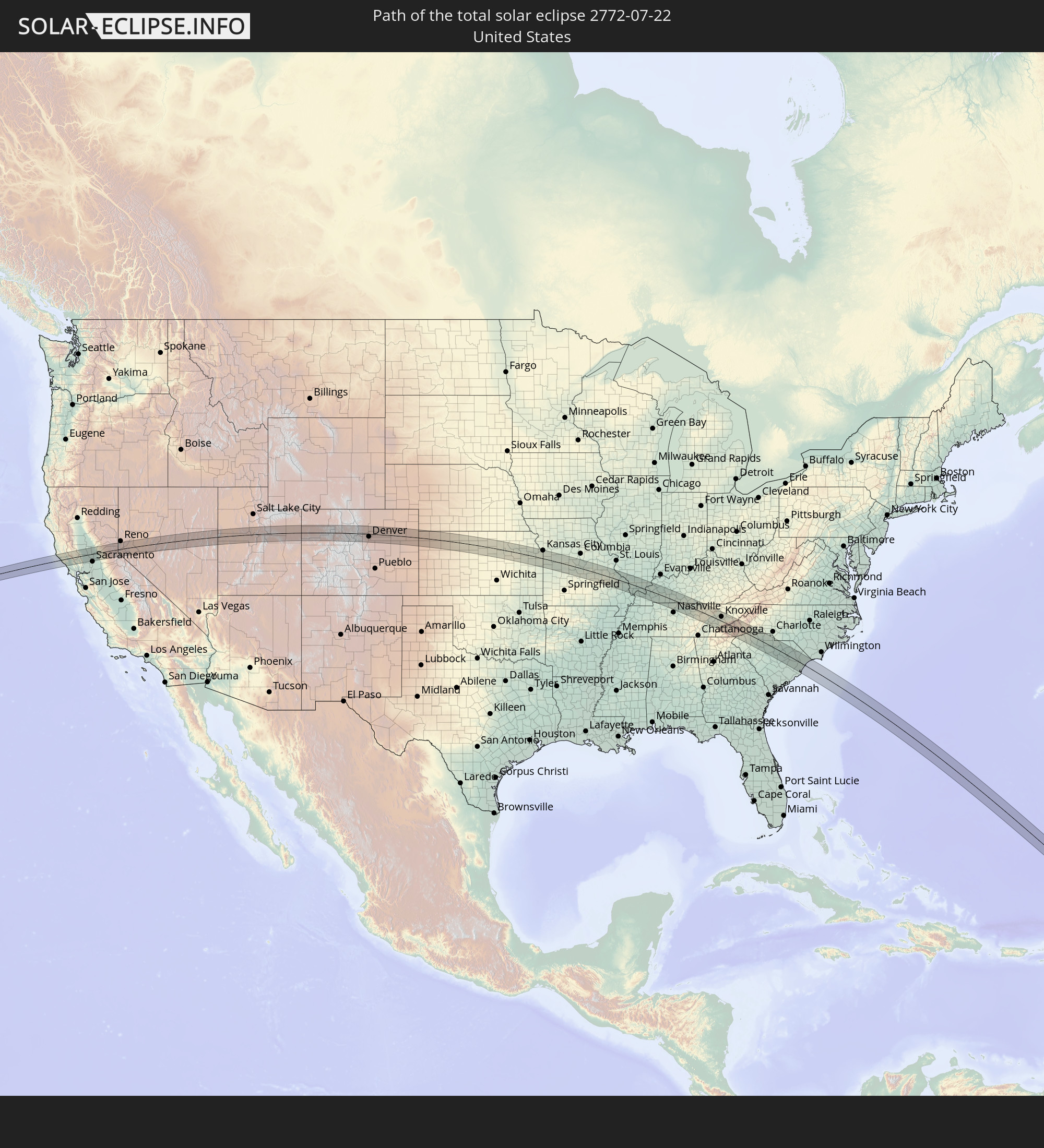
Detailed country maps
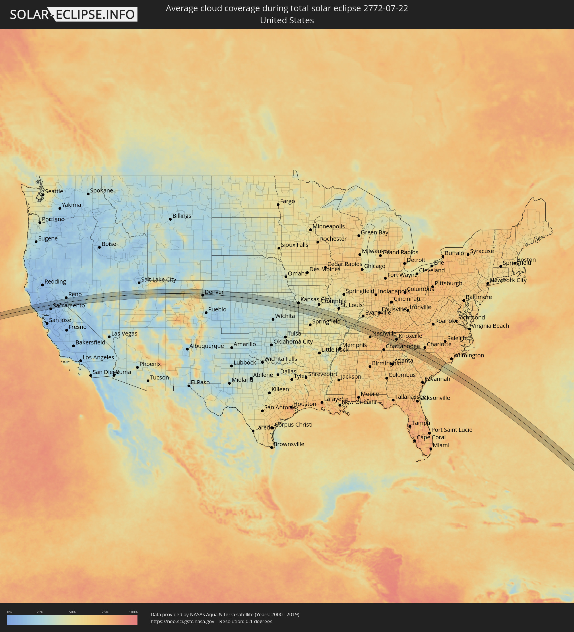 United States
Cities inside the path of the eclipse
The following table shows all locations with a population of more than 5,000 inside the eclipse path. Cities which have more than 100,000 inhabitants are marked bold. A click at the locations opens a detailed map.
| City | Type | Eclipse duration | Local time of max. eclipse | Distance to central line | Ø Cloud coverage |
|
Cloverdale, California
|
total | - | 08:06:42 UTC-08:00 | 10 km | 11% |
|
Healdsburg, California
|
total | - | 08:06:41 UTC-08:00 | 14 km | 12% |
|
Windsor, California
|
total | - | 08:06:41 UTC-08:00 | 22 km | 13% |
|
Larkfield-Wikiup, California
|
total | - | 08:06:43 UTC-08:00 | 27 km | 13% |
|
Clearlake, California
|
total | - | 08:07:12 UTC-08:00 | 20 km | 9% |
|
Woodland, California
|
total | - | 08:07:48 UTC-08:00 | 25 km | 10% |
|
South Yuba City, California
|
total | - | 08:08:16 UTC-08:00 | 21 km | 11% |
|
Yuba City, California
|
total | - | 08:08:18 UTC-08:00 | 24 km | 11% |
|
Marysville, California
|
total | - | 08:08:20 UTC-08:00 | 24 km | 11% |
|
Olivehurst, California
|
total | - | 08:08:20 UTC-08:00 | 18 km | 11% |
|
Linda, California
|
total | - | 08:08:22 UTC-08:00 | 21 km | 11% |
|
Rio Linda, California
|
total | - | 08:08:07 UTC-08:00 | 28 km | 11% |
|
Lincoln, California
|
total | - | 08:08:26 UTC-08:00 | 9 km | 13% |
|
Roseville, California
|
total | - | 08:08:20 UTC-08:00 | 24 km | 12% |
|
Loomis, California
|
total | - | 08:08:29 UTC-08:00 | 18 km | 12% |
|
Granite Bay, California
|
total | - | 08:08:28 UTC-08:00 | 25 km | 12% |
|
El Dorado Hills, California
|
total | - | 08:08:29 UTC-08:00 | 34 km | 12% |
|
North Auburn, California
|
total | - | 08:08:40 UTC-08:00 | 8 km | 14% |
|
Auburn, California
|
total | - | 08:08:39 UTC-08:00 | 11 km | 14% |
|
Grass Valley, California
|
total | - | 08:08:55 UTC-08:00 | 24 km | 13% |
|
Alta Sierra, California
|
total | - | 08:08:52 UTC-08:00 | 15 km | 12% |
|
Placerville, California
|
total | - | 08:08:49 UTC-08:00 | 34 km | 11% |
|
Pollock Pines, California
|
total | - | 08:09:03 UTC-08:00 | 34 km | 13% |
|
Truckee, California
|
total | - | 08:09:54 UTC-08:00 | 23 km | 19% |
|
South Lake Tahoe, California
|
total | - | 08:09:48 UTC-08:00 | 23 km | 25% |
|
Incline Village, Nevada
|
total | - | 08:10:03 UTC-08:00 | 11 km | 18% |
|
Carson City, Nevada
|
total | - | 08:10:12 UTC-08:00 | 1 km | 19% |
|
Gardnerville Ranchos, Nevada
|
total | - | 08:10:02 UTC-08:00 | 32 km | 25% |
|
Johnson Lane, Nevada
|
total | - | 08:10:10 UTC-08:00 | 14 km | 20% |
|
Dayton, Nevada
|
total | - | 08:10:27 UTC-08:00 | 5 km | 23% |
|
Fallon, Nevada
|
total | - | 08:11:30 UTC-08:00 | 20 km | 18% |
|
Santaquin, Utah
|
total | - | 09:20:28 UTC-07:00 | 15 km | 33% |
|
Payson, Utah
|
total | - | 09:20:34 UTC-07:00 | 22 km | 33% |
|
Salem, Utah
|
total | - | 09:20:39 UTC-07:00 | 23 km | 30% |
|
Spanish Fork, Utah
|
total | - | 09:20:43 UTC-07:00 | 30 km | 30% |
|
Mapleton, Utah
|
total | - | 09:20:50 UTC-07:00 | 31 km | 31% |
|
Price, Utah
|
total | - | 09:21:38 UTC-07:00 | 31 km | 36% |
|
Gypsum, Colorado
|
total | - | 09:27:28 UTC-07:00 | 30 km | 41% |
|
Eagle, Colorado
|
total | - | 09:27:40 UTC-07:00 | 28 km | 36% |
|
Edwards, Colorado
|
total | - | 09:28:02 UTC-07:00 | 29 km | 51% |
|
Avon, Colorado
|
total | - | 09:28:09 UTC-07:00 | 31 km | 52% |
|
Evergreen, Colorado
|
total | - | 09:30:06 UTC-07:00 | 27 km | 54% |
|
Boulder, Colorado
|
total | - | 09:30:17 UTC-07:00 | 16 km | 42% |
|
Golden, Colorado
|
total | - | 09:30:18 UTC-07:00 | 13 km | 42% |
|
Gunbarrel, Colorado
|
total | - | 09:30:27 UTC-07:00 | 22 km | 38% |
|
Superior, Colorado
|
total | - | 09:30:26 UTC-07:00 | 9 km | 39% |
|
Applewood, Colorado
|
total | - | 09:30:23 UTC-07:00 | 12 km | 42% |
|
Louisville, Colorado
|
total | - | 09:30:30 UTC-07:00 | 12 km | 37% |
|
Ken Caryl, Colorado
|
total | - | 09:30:26 UTC-07:00 | 32 km | 40% |
|
Longmont, Colorado
|
total | - | 09:30:36 UTC-07:00 | 34 km | 37% |
|
Lafayette, Colorado
|
total | - | 09:30:34 UTC-07:00 | 14 km | 37% |
|
Broomfield, Colorado
|
total | - | 09:30:33 UTC-07:00 | 6 km | 36% |
|
Columbine, Colorado
|
total | - | 09:30:30 UTC-07:00 | 31 km | 40% |
|
Erie, Colorado
|
total | - | 09:30:39 UTC-07:00 | 21 km | 35% |
|
Berkley, Colorado
|
total | - | 09:30:37 UTC-07:00 | 6 km | 32% |
|
Sherrelwood, Colorado
|
total | - | 09:30:40 UTC-07:00 | 3 km | 32% |
|
Federal Heights, Colorado
|
total | - | 09:30:41 UTC-07:00 | 1 km | 31% |
|
Denver, Colorado
|
total | - | 09:30:41 UTC-07:00 | 14 km | 35% |
|
Welby, Colorado
|
total | - | 09:30:45 UTC-07:00 | 3 km | 32% |
|
Greenwood Village, Colorado
|
total | - | 09:30:42 UTC-07:00 | 27 km | 37% |
|
Frederick, Colorado
|
total | - | 09:30:51 UTC-07:00 | 27 km | 33% |
|
Firestone, Colorado
|
total | - | 09:30:51 UTC-07:00 | 28 km | 33% |
|
Derby, Colorado
|
total | - | 09:30:49 UTC-07:00 | 2 km | 30% |
|
Castlewood, Colorado
|
total | - | 09:30:47 UTC-07:00 | 30 km | 35% |
|
Lone Tree, Colorado
|
total | - | 09:30:48 UTC-07:00 | 34 km | 35% |
|
Centennial, Colorado
|
total | - | 09:30:49 UTC-07:00 | 31 km | 35% |
|
Brighton, Colorado
|
total | - | 09:31:00 UTC-07:00 | 15 km | 31% |
|
Fort Lupton, Colorado
|
total | - | 09:31:03 UTC-07:00 | 26 km | 32% |
|
Stonegate, Colorado
|
total | - | 09:30:56 UTC-07:00 | 36 km | 33% |
|
Salina, Kansas
|
total | - | 10:43:51 UTC-06:00 | 41 km | 33% |
|
Abilene, Kansas
|
total | - | 10:44:36 UTC-06:00 | 27 km | 35% |
|
Junction City, Kansas
|
total | - | 10:45:19 UTC-06:00 | 8 km | 38% |
|
Fort Riley North, Kansas
|
total | - | 10:45:20 UTC-06:00 | 1 km | 38% |
|
Manhattan, Kansas
|
total | - | 10:45:47 UTC-06:00 | 13 km | 37% |
|
Topeka, Kansas
|
total | - | 10:47:33 UTC-06:00 | 14 km | 38% |
|
Ottawa, Kansas
|
total | - | 10:48:29 UTC-06:00 | 25 km | 39% |
|
Lawrence, Kansas
|
total | - | 10:48:26 UTC-06:00 | 14 km | 37% |
|
Gardner, Kansas
|
total | - | 10:49:05 UTC-06:00 | 2 km | 36% |
|
Bonner Springs, Kansas
|
total | - | 10:49:05 UTC-06:00 | 30 km | 38% |
|
Olathe, Kansas
|
total | - | 10:49:17 UTC-06:00 | 12 km | 40% |
|
Merriam, Kansas
|
total | - | 10:49:29 UTC-06:00 | 30 km | 42% |
|
Overland Park, Kansas
|
total | - | 10:49:32 UTC-06:00 | 26 km | 42% |
|
Mission, Kansas
|
total | - | 10:49:33 UTC-06:00 | 31 km | 42% |
|
Prairie Village, Kansas
|
total | - | 10:49:36 UTC-06:00 | 28 km | 42% |
|
Roeland Park, Kansas
|
total | - | 10:49:36 UTC-06:00 | 33 km | 42% |
|
Kansas City, Missouri
|
total | - | 10:49:41 UTC-06:00 | 40 km | 43% |
|
Grandview, Missouri
|
total | - | 10:49:50 UTC-06:00 | 18 km | 40% |
|
Belton, Missouri
|
total | - | 10:49:52 UTC-06:00 | 10 km | 41% |
|
Raymore, Missouri
|
total | - | 10:50:02 UTC-06:00 | 11 km | 41% |
|
Lee's Summit, Missouri
|
total | - | 10:50:08 UTC-06:00 | 24 km | 40% |
|
Harrisonville, Missouri
|
total | - | 10:50:17 UTC-06:00 | 3 km | 42% |
|
Pleasant Hill, Missouri
|
total | - | 10:50:24 UTC-06:00 | 13 km | 40% |
|
Grain Valley, Missouri
|
total | - | 10:50:27 UTC-06:00 | 39 km | 39% |
|
Oak Grove, Missouri
|
total | - | 10:50:36 UTC-06:00 | 39 km | 40% |
|
Clinton, Missouri
|
total | - | 10:51:33 UTC-06:00 | 22 km | 35% |
|
Warrensburg, Missouri
|
total | - | 10:51:28 UTC-06:00 | 21 km | 39% |
|
Sedalia, Missouri
|
total | - | 10:52:31 UTC-06:00 | 26 km | 43% |
|
Saint John, Missouri
|
total | - | 10:54:37 UTC-06:00 | 42 km | 46% |
|
Jefferson City, Missouri
|
total | - | 10:54:42 UTC-06:00 | 37 km | 45% |
|
Rolla, Missouri
|
total | - | 10:55:51 UTC-06:00 | 20 km | 46% |
|
Sullivan, Missouri
|
total | - | 10:56:58 UTC-06:00 | 23 km | 46% |
|
Bonne Terre, Missouri
|
total | - | 10:58:23 UTC-06:00 | 8 km | 51% |
|
De Soto, Missouri
|
total | - | 10:58:15 UTC-06:00 | 31 km | 47% |
|
Park Hills, Missouri
|
total | - | 10:58:30 UTC-06:00 | 2 km | 54% |
|
Farmington, Missouri
|
total | - | 10:58:45 UTC-06:00 | 3 km | 53% |
|
Festus, Missouri
|
total | - | 10:58:31 UTC-06:00 | 44 km | 47% |
|
Perryville, Missouri
|
total | - | 10:59:57 UTC-06:00 | 6 km | 54% |
|
Chester, Illinois
|
total | - | 10:59:55 UTC-06:00 | 27 km | 44% |
|
Jackson, Missouri
|
total | - | 11:00:36 UTC-06:00 | 24 km | 51% |
|
Cape Girardeau, Missouri
|
total | - | 11:00:58 UTC-06:00 | 28 km | 46% |
|
Murphysboro, Illinois
|
total | - | 11:01:02 UTC-06:00 | 25 km | 50% |
|
Carbondale, Illinois
|
total | - | 11:01:18 UTC-06:00 | 25 km | 47% |
|
Herrin, Illinois
|
total | - | 11:01:38 UTC-06:00 | 38 km | 53% |
|
Marion, Illinois
|
total | - | 11:01:53 UTC-06:00 | 33 km | 49% |
|
Metropolis, Illinois
|
total | - | 11:02:45 UTC-06:00 | 21 km | 48% |
|
Paducah, Kentucky
|
total | - | 11:03:05 UTC-06:00 | 24 km | 52% |
|
Princeton, Kentucky
|
total | - | 11:04:35 UTC-06:00 | 1 km | 56% |
|
Madisonville, Kentucky
|
total | - | 11:05:13 UTC-06:00 | 35 km | 59% |
|
Hopkinsville, Kentucky
|
total | - | 11:05:37 UTC-06:00 | 12 km | 66% |
|
Fort Campbell North, Kentucky
|
total | - | 11:05:52 UTC-06:00 | 33 km | 66% |
|
Oak Grove, Kentucky
|
total | - | 11:05:54 UTC-06:00 | 32 km | 69% |
|
Clarksville, Tennessee
|
total | - | 11:06:12 UTC-06:00 | 43 km | 60% |
|
Morehead, Kentucky
|
total | - | 11:05:57 UTC-06:00 | 40 km | 62% |
|
Russellville, Kentucky
|
total | - | 11:06:56 UTC-06:00 | 5 km | 67% |
|
Springfield, Tennessee
|
total | - | 11:07:14 UTC-06:00 | 29 km | 68% |
|
Greenbrier, Tennessee
|
total | - | 11:07:29 UTC-06:00 | 35 km | 69% |
|
Goodlettsville, Tennessee
|
total | - | 11:07:47 UTC-06:00 | 43 km | 73% |
|
Millersville, Tennessee
|
total | - | 11:07:44 UTC-06:00 | 38 km | 69% |
|
White House, Tennessee
|
total | - | 11:07:46 UTC-06:00 | 25 km | 69% |
|
Hendersonville, Tennessee
|
total | - | 11:08:00 UTC-06:00 | 41 km | 68% |
|
Franklin, Kentucky
|
total | - | 11:07:42 UTC-06:00 | 3 km | 72% |
|
Portland, Tennessee
|
total | - | 11:07:58 UTC-06:00 | 9 km | 70% |
|
Gallatin, Tennessee
|
total | - | 11:08:18 UTC-06:00 | 27 km | 64% |
|
Bowling Green, Kentucky
|
total | - | 11:07:45 UTC-06:00 | 35 km | 70% |
|
Lebanon, Tennessee
|
total | - | 11:08:48 UTC-06:00 | 40 km | 73% |
|
Cookeville, Tennessee
|
total | - | 11:10:33 UTC-06:00 | 17 km | 73% |
|
Crossville, Tennessee
|
total | - | 11:11:48 UTC-06:00 | 22 km | 75% |
|
Fairfield Glade, Tennessee
|
total | - | 11:12:03 UTC-06:00 | 11 km | 75% |
|
Harriman, Tennessee
|
total | - | 12:12:50 UTC-05:00 | 6 km | 59% |
|
Oak Ridge, Tennessee
|
total | - | 12:13:22 UTC-05:00 | 13 km | 63% |
|
Lenoir City, Tennessee
|
total | - | 12:13:37 UTC-05:00 | 8 km | 60% |
|
Farragut, Tennessee
|
total | - | 12:13:45 UTC-05:00 | 5 km | 62% |
|
Clinton, Tennessee
|
total | - | 12:13:34 UTC-05:00 | 27 km | 68% |
|
Alcoa, Tennessee
|
total | - | 12:14:15 UTC-05:00 | 2 km | 71% |
|
Maryville, Tennessee
|
total | - | 12:14:17 UTC-05:00 | 1 km | 71% |
|
Knoxville, Tennessee
|
total | - | 12:14:10 UTC-05:00 | 21 km | 71% |
|
Seymour, Tennessee
|
total | - | 12:14:40 UTC-05:00 | 22 km | 68% |
|
Sevierville, Tennessee
|
total | - | 12:15:03 UTC-05:00 | 26 km | 66% |
|
Waynesville, North Carolina
|
total | - | 12:16:43 UTC-05:00 | 10 km | 75% |
|
Brevard, North Carolina
|
total | - | 12:17:34 UTC-05:00 | 5 km | 71% |
|
Easley, South Carolina
|
total | - | 12:18:20 UTC-05:00 | 40 km | 65% |
|
Etowah, North Carolina
|
total | - | 12:17:46 UTC-05:00 | 9 km | 69% |
|
Mills River, North Carolina
|
total | - | 12:17:44 UTC-05:00 | 17 km | 68% |
|
Asheville, North Carolina
|
total | - | 12:17:31 UTC-05:00 | 39 km | 67% |
|
Fletcher, North Carolina
|
total | - | 12:17:50 UTC-05:00 | 24 km | 67% |
|
Powdersville, South Carolina
|
total | - | 12:18:37 UTC-05:00 | 39 km | 66% |
|
Hendersonville, North Carolina
|
total | - | 12:18:03 UTC-05:00 | 15 km | 68% |
|
Berea, South Carolina
|
total | - | 12:18:35 UTC-05:00 | 28 km | 63% |
|
Parker, South Carolina
|
total | - | 12:18:38 UTC-05:00 | 31 km | 63% |
|
Welcome, South Carolina
|
total | - | 12:18:41 UTC-05:00 | 33 km | 69% |
|
Gantt, South Carolina
|
total | - | 12:18:45 UTC-05:00 | 35 km | 69% |
|
Sans Souci, South Carolina
|
total | - | 12:18:40 UTC-05:00 | 28 km | 67% |
|
Greenville, South Carolina
|
total | - | 12:18:45 UTC-05:00 | 29 km | 67% |
|
Wade Hampton, South Carolina
|
total | - | 12:18:50 UTC-05:00 | 21 km | 70% |
|
Mauldin, South Carolina
|
total | - | 12:19:02 UTC-05:00 | 33 km | 69% |
|
Taylors, South Carolina
|
total | - | 12:18:53 UTC-05:00 | 18 km | 70% |
|
Simpsonville, South Carolina
|
total | - | 12:19:12 UTC-05:00 | 35 km | 66% |
|
Five Forks, South Carolina
|
total | - | 12:19:10 UTC-05:00 | 27 km | 68% |
|
Greer, South Carolina
|
total | - | 12:19:01 UTC-05:00 | 13 km | 69% |
|
Fountain Inn, South Carolina
|
total | - | 12:19:23 UTC-05:00 | 37 km | 65% |
|
Boiling Springs, South Carolina
|
total | - | 12:19:25 UTC-05:00 | 7 km | 66% |
|
Valley Falls, South Carolina
|
total | - | 12:19:28 UTC-05:00 | 5 km | 66% |
|
Spartanburg, South Carolina
|
total | - | 12:19:38 UTC-05:00 | 0 km | 63% |
|
Clinton, South Carolina
|
total | - | 12:20:21 UTC-05:00 | 45 km | 69% |
|
Forest City, North Carolina
|
total | - | 12:19:19 UTC-05:00 | 41 km | 65% |
|
Gaffney, South Carolina
|
total | - | 12:20:06 UTC-05:00 | 24 km | 64% |
|
Union, South Carolina
|
total | - | 12:20:36 UTC-05:00 | 10 km | 65% |
|
York, South Carolina
|
total | - | 12:21:04 UTC-05:00 | 34 km | 66% |
|
Tega Cay, South Carolina
|
total | - | 12:21:30 UTC-05:00 | 46 km | 70% |
|
Rock Hill, South Carolina
|
total | - | 12:21:38 UTC-05:00 | 36 km | 69% |
|
Dentsville, South Carolina
|
total | - | 12:22:54 UTC-05:00 | 45 km | 74% |
|
Woodfield, South Carolina
|
total | - | 12:22:58 UTC-05:00 | 44 km | 75% |
|
Lancaster, South Carolina
|
total | - | 12:22:26 UTC-05:00 | 27 km | 69% |
|
Lugoff, South Carolina
|
total | - | 12:23:16 UTC-05:00 | 17 km | 72% |
|
Camden, South Carolina
|
total | - | 12:23:25 UTC-05:00 | 12 km | 67% |
|
Sumter, South Carolina
|
total | - | 12:24:26 UTC-05:00 | 32 km | 68% |
|
Hartsville, South Carolina
|
total | - | 12:24:24 UTC-05:00 | 25 km | 72% |
|
Florence, South Carolina
|
total | - | 12:25:18 UTC-05:00 | 21 km | 74% |
|
Lake City, South Carolina
|
total | - | 12:25:46 UTC-05:00 | 10 km | 70% |
|
Marion, South Carolina
|
total | - | 12:26:06 UTC-05:00 | 36 km | 71% |
|
Georgetown, South Carolina
|
total | - | 12:27:27 UTC-05:00 | 36 km | 67% |
|
Red Hill, South Carolina
|
total | - | 12:26:39 UTC-05:00 | 26 km | 70% |
|
Conway, South Carolina
|
total | - | 12:27:20 UTC-05:00 | 20 km | 76% |
|
Murrells Inlet, South Carolina
|
total | - | 12:27:45 UTC-05:00 | 7 km | 61% |
|
Red Hill, South Carolina
|
total | - | 12:27:25 UTC-05:00 | 20 km | 76% |
|
Garden City, South Carolina
|
total | - | 12:27:46 UTC-05:00 | 2 km | 61% |
|
Socastee, South Carolina
|
total | - | 12:27:39 UTC-05:00 | 7 km | 71% |
|
Myrtle Beach, South Carolina
|
total | - | 12:27:53 UTC-05:00 | 13 km | 63% |
|
North Myrtle Beach, South Carolina
|
total | - | 12:28:09 UTC-05:00 | 35 km | 57% |
|
Little River, South Carolina
|
total | - | 12:28:12 UTC-05:00 | 44 km | 62% |