Total solar eclipse of 02/17/2846
| Day of week: | Saturday |
| Maximum duration of eclipse: | 03m20s |
| Maximum width of eclipse path: | 196 km |
| Saros cycle: | 173 |
| Coverage: | 100% |
| Magnitude: | 1.0413 |
| Gamma: | 0.7233 |
Wo kann man die Sonnenfinsternis vom 02/17/2846 sehen?
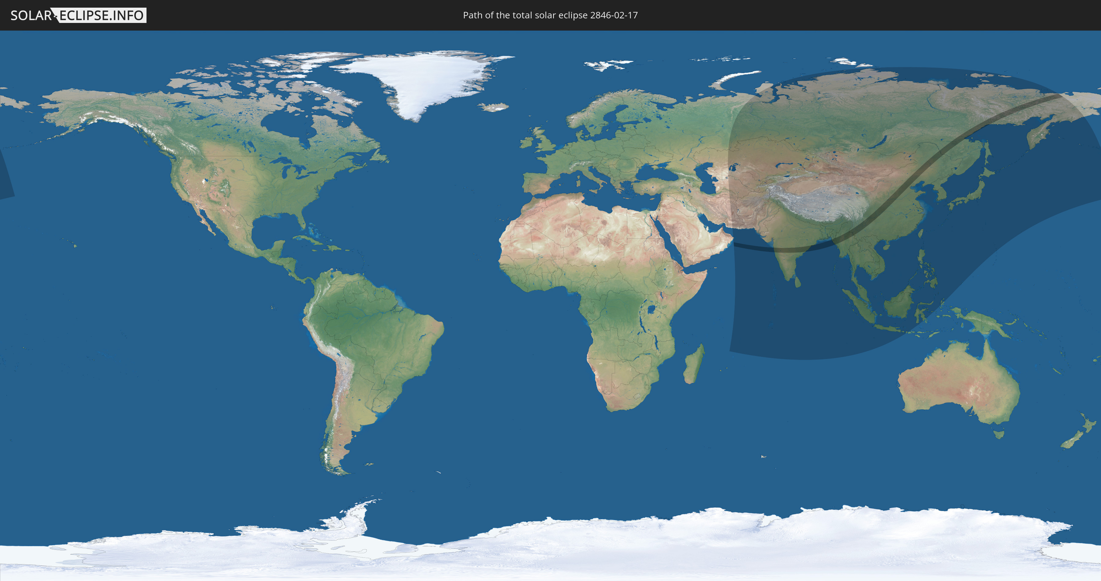
Die Sonnenfinsternis am 02/17/2846 kann man in 40 Ländern als partielle Sonnenfinsternis beobachten.
Der Finsternispfad verläuft durch 5 Länder. Nur in diesen Ländern ist sie als total Sonnenfinsternis zu sehen.
In den folgenden Ländern ist die Sonnenfinsternis total zu sehen
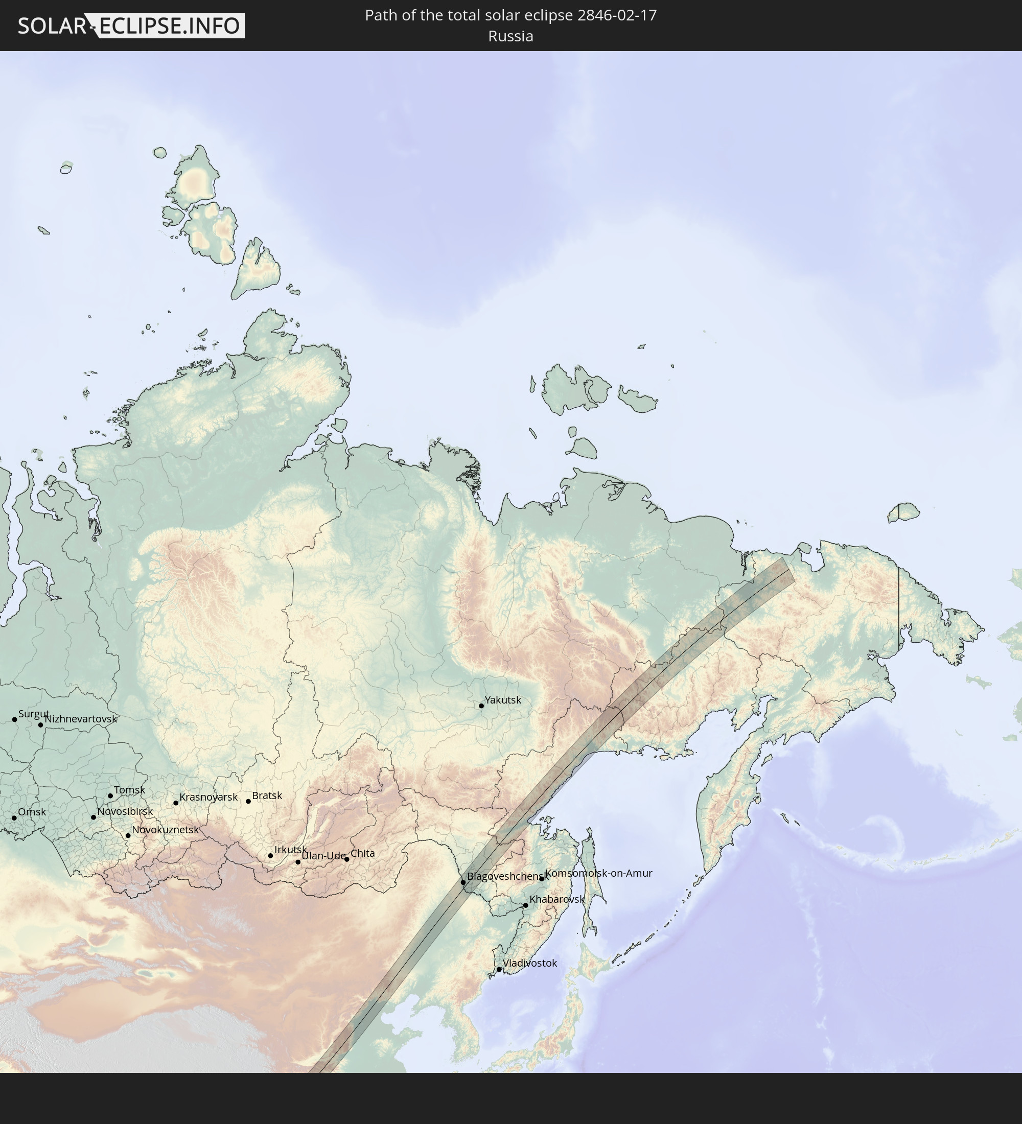 Russia
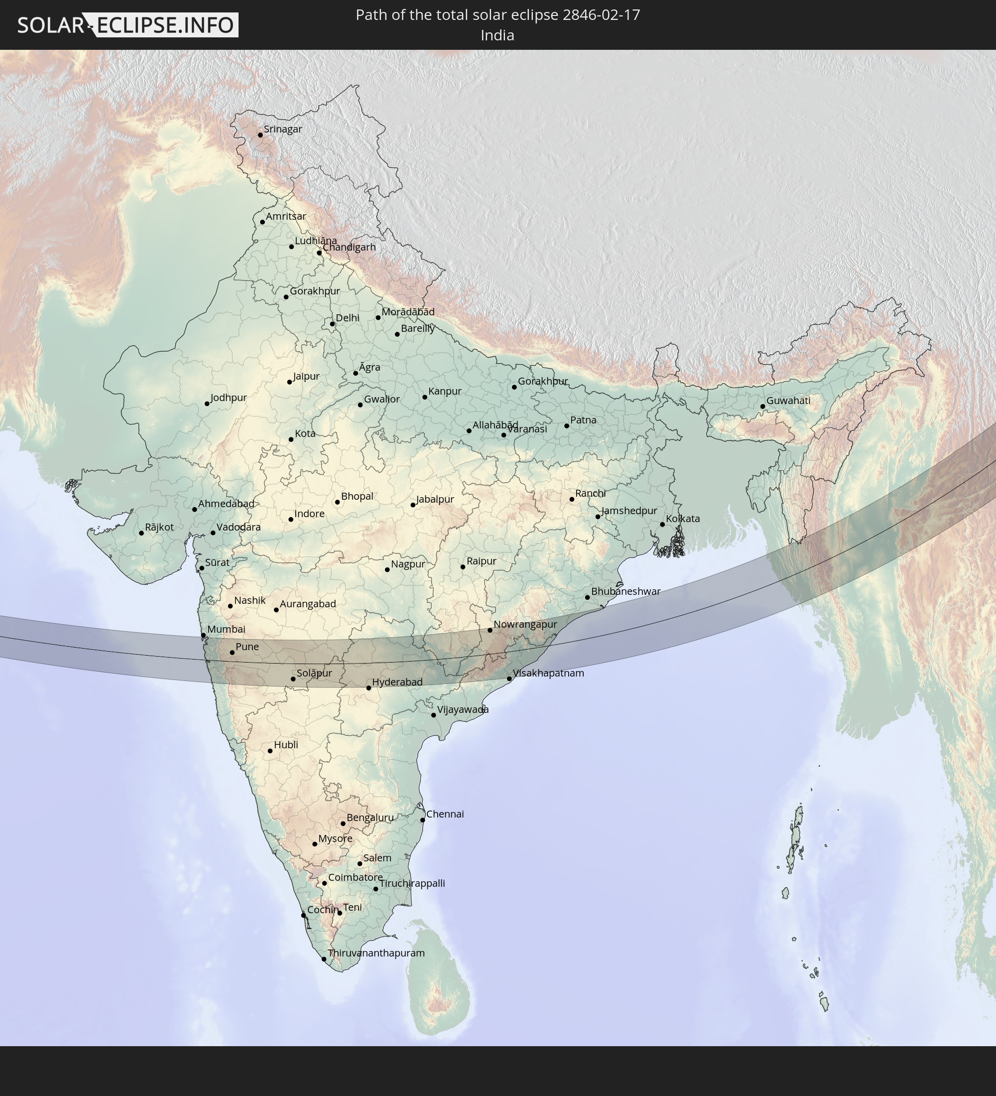 India
India
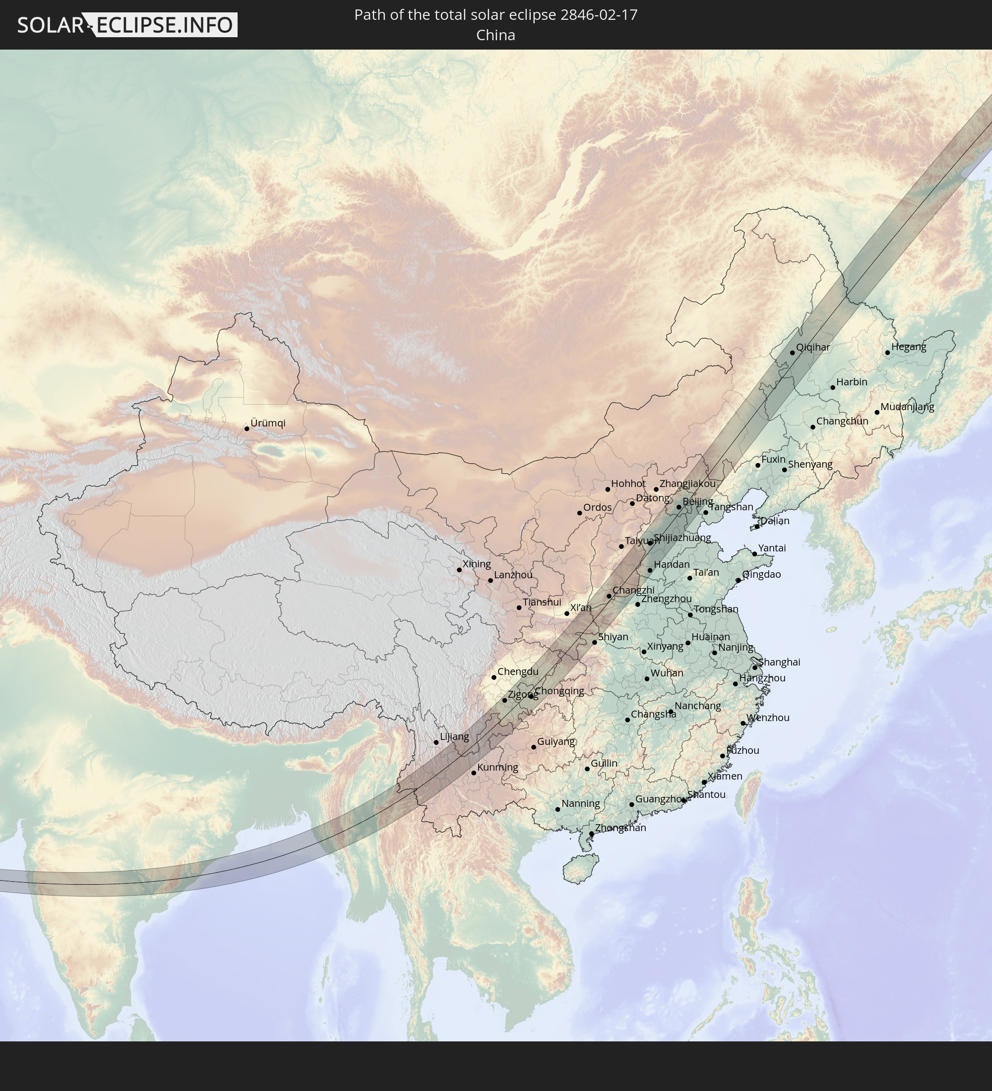 China
China
 Bangladesh
 Myanmar
In den folgenden Ländern ist die Sonnenfinsternis partiell zu sehen
 Russia
 United States
 Iran
Iran
 Kazakhstan
 Oman
Oman
 Turkmenistan
 Uzbekistan
 Afghanistan
 Pakistan
 Tajikistan
 India
India
 Kyrgyzstan
 British Indian Ocean Territory
 Maldives
 China
China
 Sri Lanka
 Nepal
Nepal
 Mongolia
 Bangladesh
 Bhutan
 Myanmar
 Indonesia
 Cocos Islands
 Thailand
 Malaysia
 Laos
Laos
 Vietnam
 Cambodia
 Singapore
 Christmas Island
 Macau
Macau
 Hong Kong
 Brunei
 Taiwan
 Philippines
 Japan
Japan
 North Korea
 South Korea
 Palau
Palau
 Northern Mariana Islands
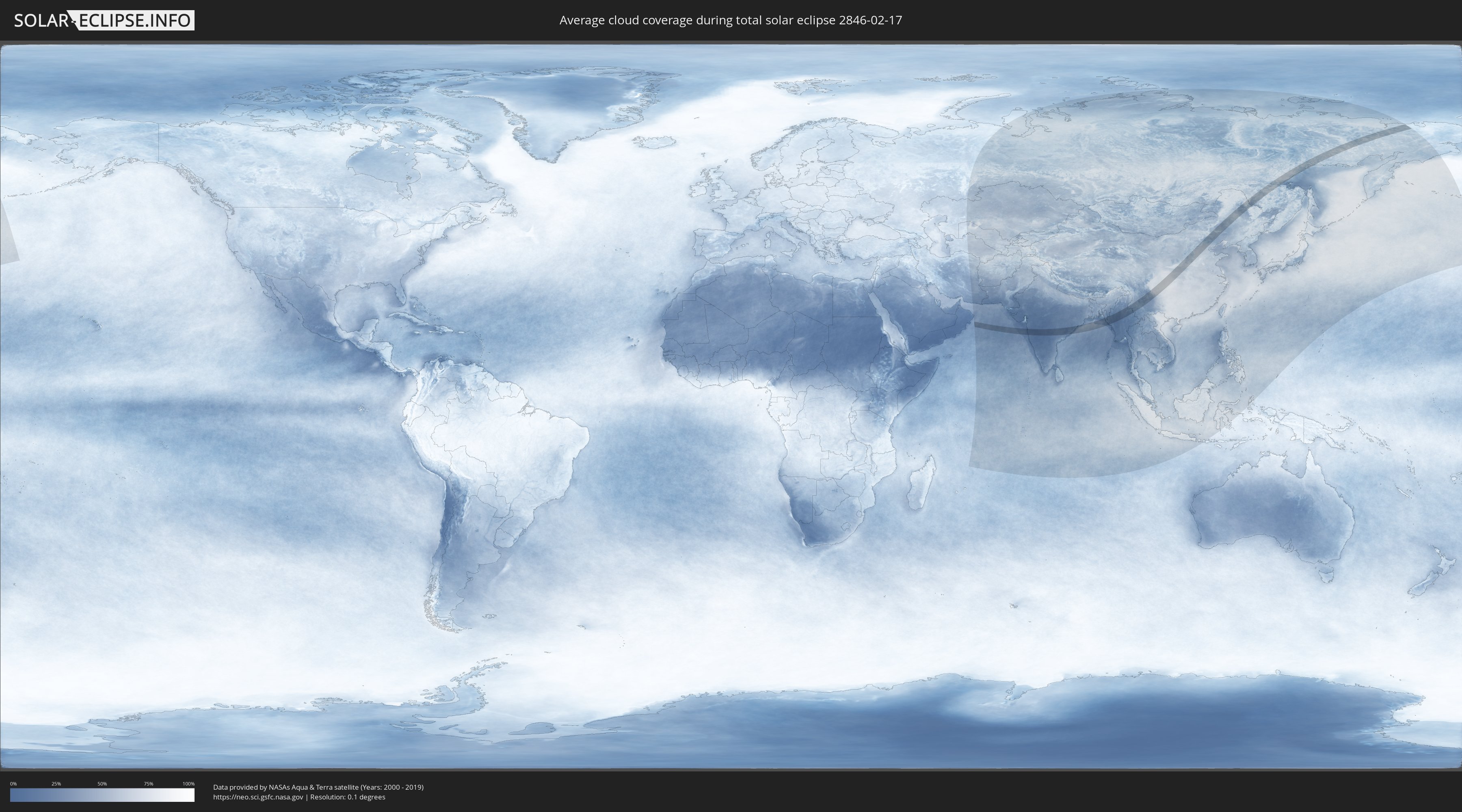
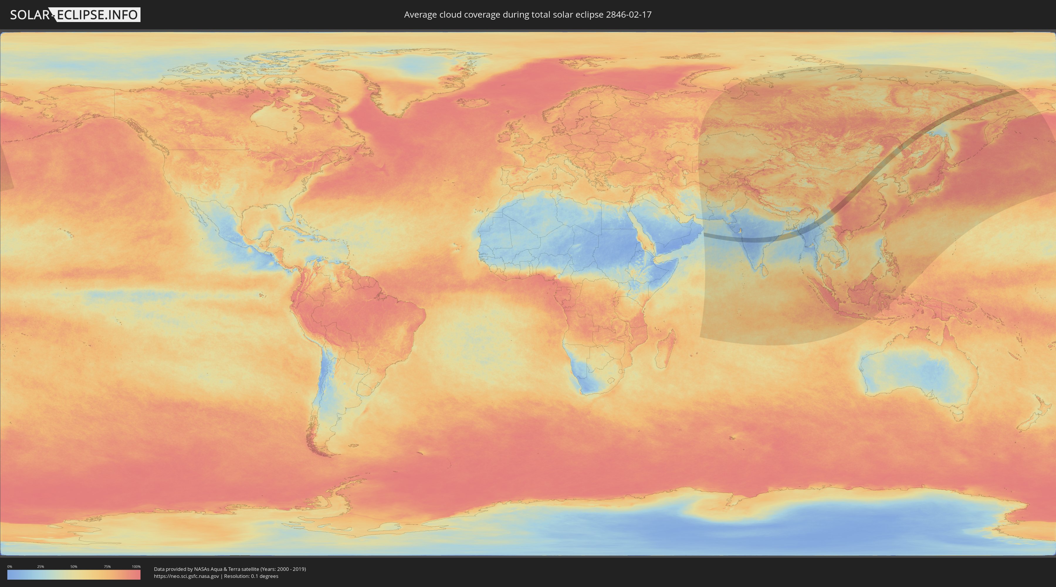
How will be the weather during the total solar eclipse on 02/17/2846?
Where is the best place to see the total solar eclipse of 02/17/2846?
The following maps show the average cloud coverage for the day of the total solar eclipse.
With the help of these maps, it is possible to find the place along the eclipse path, which has the best
chance of a cloudless sky.
Nevertheless, you should consider local circumstances and inform about the weather of your chosen
observation site.
The data is provided by NASAs satellites
AQUA and TERRA.
The cloud maps are averaged over a period of 19 years (2000 - 2019).
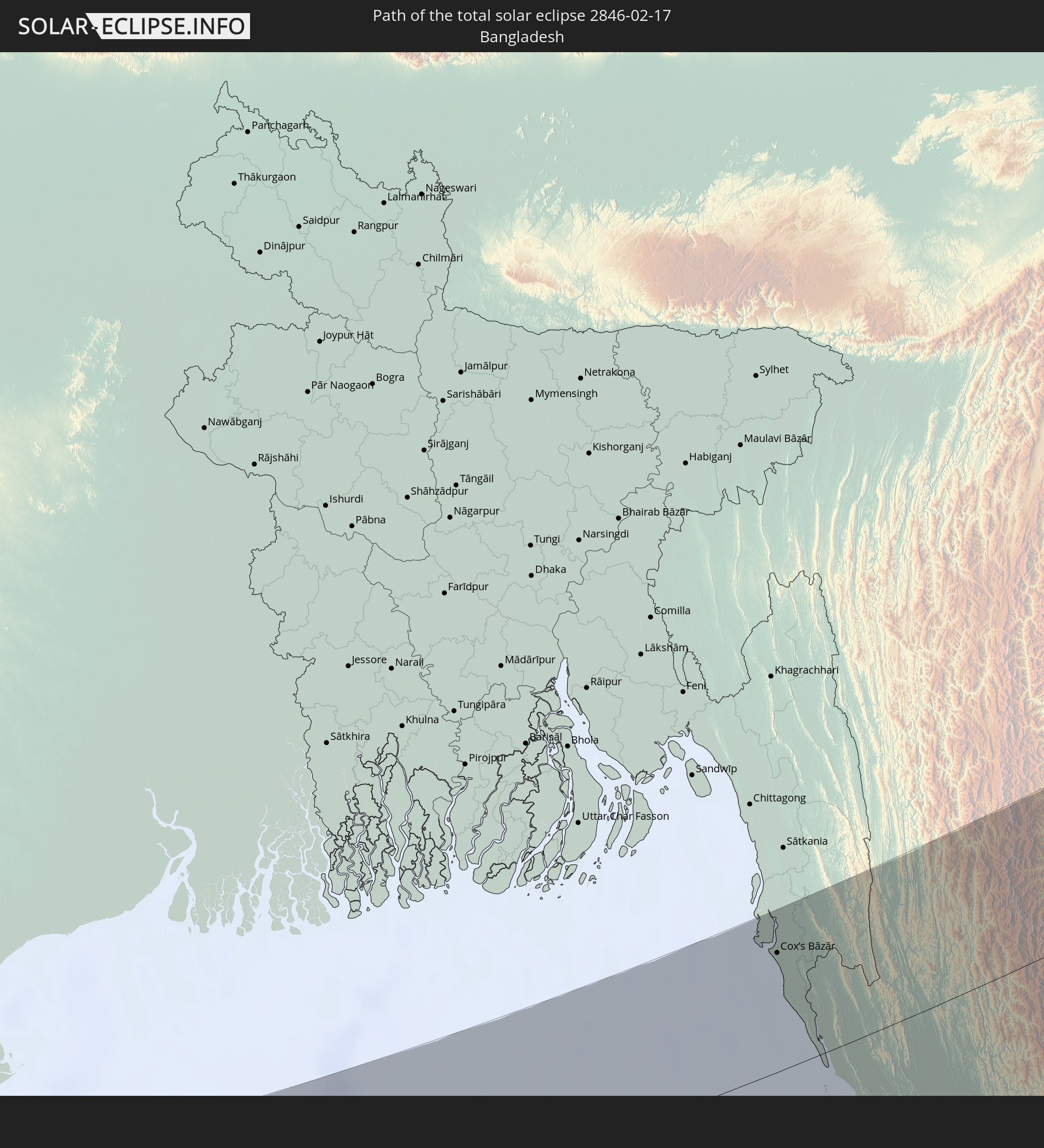
Detailed country maps
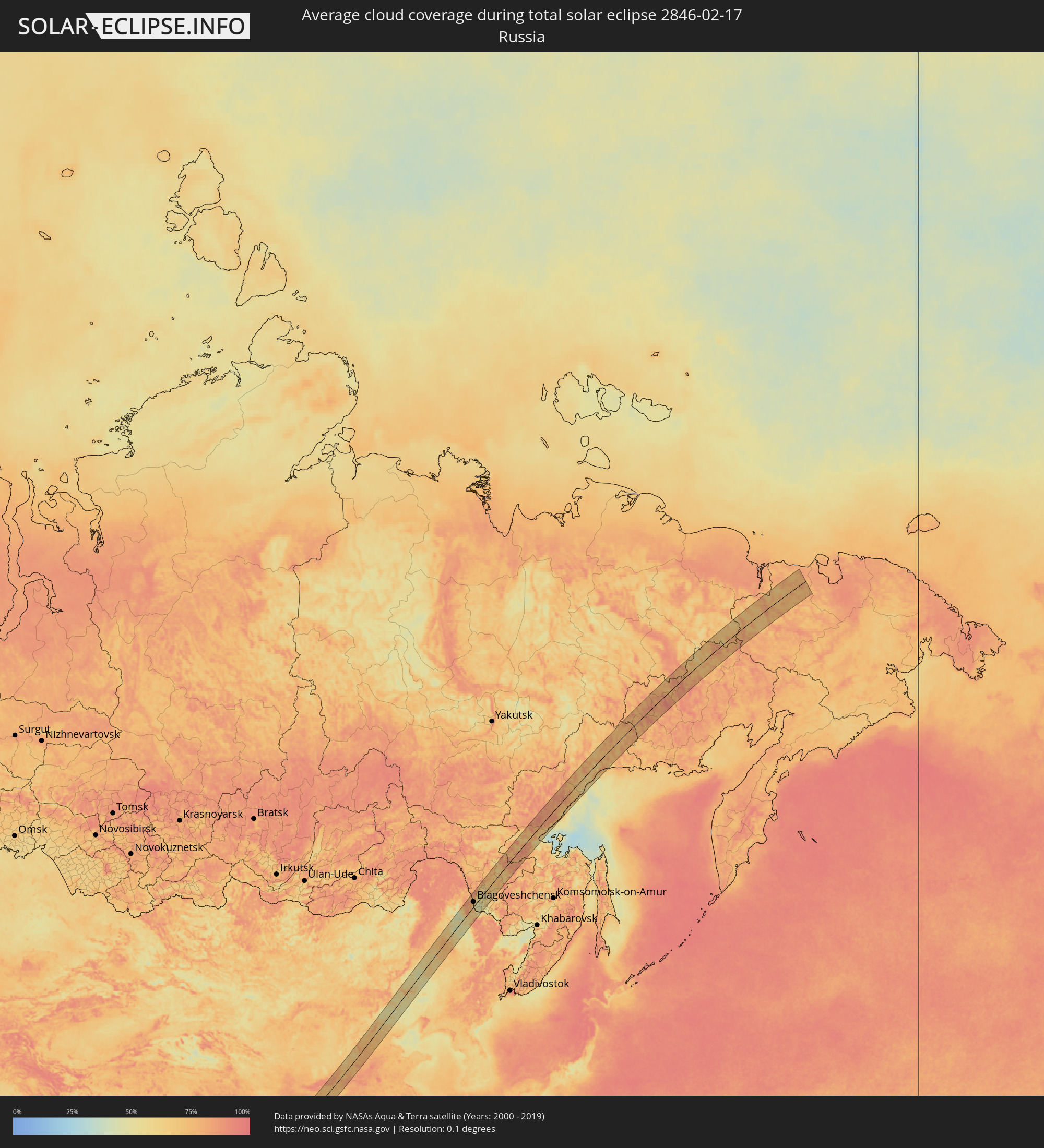 Russia
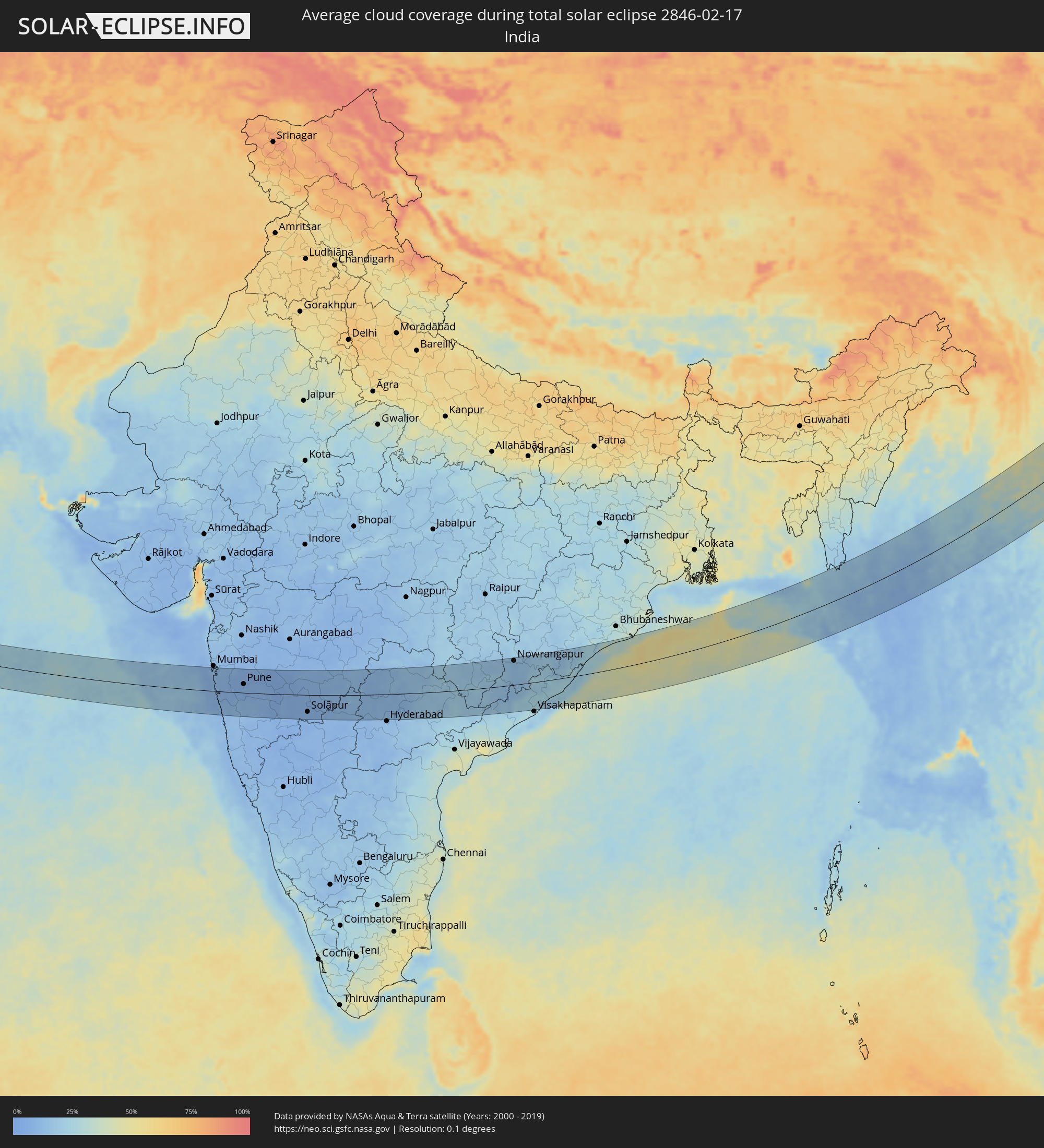 India
India
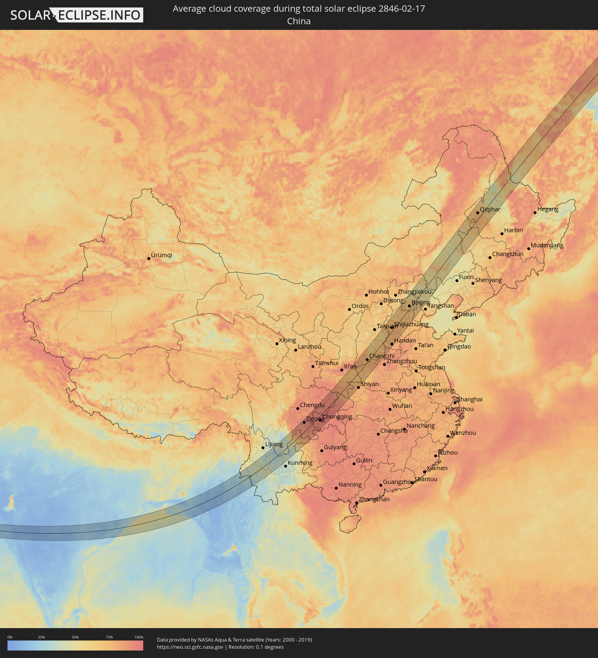 China
China
 Bangladesh
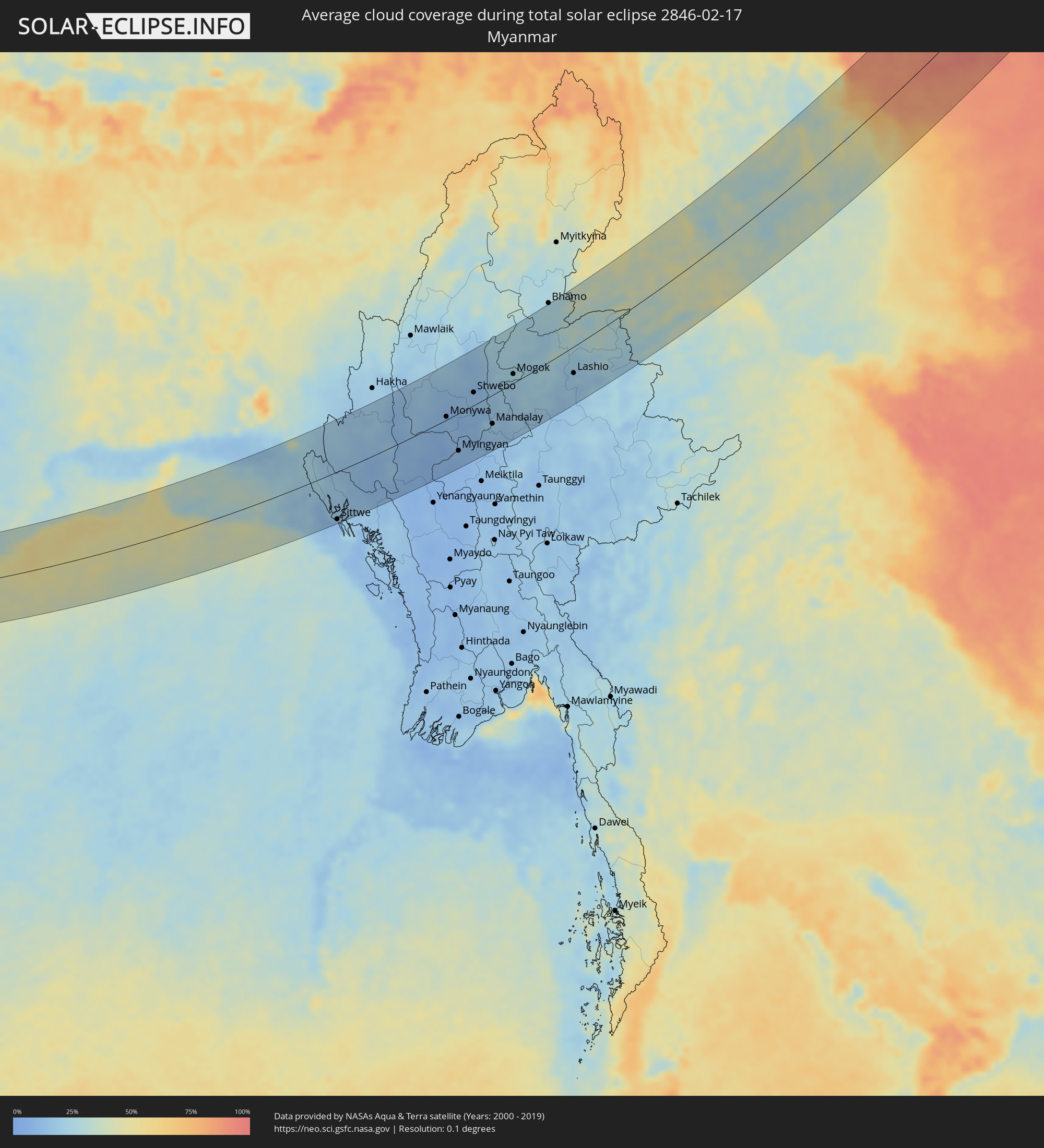 Myanmar
Cities inside the path of the eclipse
The following table shows all locations with a population of more than 5,000 inside the eclipse path. Cities which have more than 100,000 inhabitants are marked bold. A click at the locations opens a detailed map.
| City | Type | Eclipse duration | Local time of max. eclipse | Distance to central line | Ø Cloud coverage |
|
Panvel, Maharashtra
|
total | - | 08:05:55 UTC+05:30 | 77 km | 11% |
|
Roha, Maharashtra
|
total | - | 08:05:09 UTC+05:30 | 16 km | 9% |
|
Khopoli, Maharashtra
|
total | - | 08:05:49 UTC+05:30 | 56 km | 9% |
|
Pune, Maharashtra
|
total | - | 08:05:51 UTC+05:30 | 30 km | 7% |
|
Satara, Maharashtra
|
total | - | 08:04:48 UTC+05:30 | 62 km | 9% |
|
Phaltan, Maharashtra
|
total | - | 08:05:34 UTC+05:30 | 26 km | 8% |
|
Bārāmati, Maharashtra
|
total | - | 08:05:55 UTC+05:30 | 8 km | 7% |
|
Pandharpur, Maharashtra
|
total | - | 08:05:53 UTC+05:30 | 58 km | 6% |
|
Bārsi, Maharashtra
|
total | - | 08:06:59 UTC+05:30 | 5 km | 8% |
|
Solāpur, Maharashtra
|
total | - | 08:06:22 UTC+05:30 | 58 km | 7% |
|
Osmanabad, Maharashtra
|
total | - | 08:07:12 UTC+05:30 | 1 km | 8% |
|
Ambājogāi, Maharashtra
|
total | - | 08:08:19 UTC+05:30 | 61 km | 11% |
|
Parli Vaijnāth, Maharashtra
|
total | - | 08:08:37 UTC+05:30 | 74 km | 10% |
|
Latur, Maharashtra
|
total | - | 08:07:59 UTC+05:30 | 24 km | 9% |
|
Basavakalyān, Karnataka
|
total | - | 08:07:35 UTC+05:30 | 34 km | 10% |
|
Udgīr, Maharashtra
|
total | - | 08:08:30 UTC+05:30 | 23 km | 10% |
|
Bīdar, Karnataka
|
total | - | 08:08:11 UTC+05:30 | 30 km | 10% |
|
Bodhan, Telangana
|
total | - | 08:09:37 UTC+05:30 | 52 km | 9% |
|
Sangāreddi, Telangana
|
total | - | 08:08:18 UTC+05:30 | 64 km | 11% |
|
Nizāmābād, Telangana
|
total | - | 08:09:51 UTC+05:30 | 53 km | 10% |
|
Kāmāreddi, Telangana
|
total | - | 08:09:34 UTC+05:30 | 13 km | 9% |
|
Kūkatpalli, Telangana
|
total | - | 08:08:25 UTC+05:30 | 80 km | 11% |
|
Koratla, Telangana
|
total | - | 08:10:41 UTC+05:30 | 68 km | 11% |
|
Sirsilla, Telangana
|
total | - | 08:10:08 UTC+05:30 | 19 km | 12% |
|
Siddipet, Telangana
|
total | - | 08:09:45 UTC+05:30 | 13 km | 9% |
|
Jagtiāl, Telangana
|
total | - | 08:10:51 UTC+05:30 | 64 km | 13% |
|
Karīmnagar, Telangana
|
total | - | 08:10:32 UTC+05:30 | 23 km | 13% |
|
Rāmgundam, Telangana
|
total | - | 08:11:24 UTC+05:30 | 62 km | 13% |
|
Mandamarri, Telangana
|
total | - | 08:11:41 UTC+05:30 | 80 km | 15% |
|
Warangal, Telangana
|
total | - | 08:10:21 UTC+05:30 | 28 km | 17% |
|
Kottagūdem, Telangana
|
total | - | 08:10:48 UTC+05:30 | 85 km | 21% |
|
Jagdalpur, Chhattisgarh
|
total | - | 08:14:40 UTC+05:30 | 71 km | 15% |
|
Nowrangapur, Odisha
|
total | - | 08:15:31 UTC+05:30 | 81 km | 12% |
|
Jeypore, Odisha
|
total | - | 08:14:58 UTC+05:30 | 40 km | 14% |
|
Bobbili, Andhra Pradesh
|
total | - | 08:15:29 UTC+05:30 | 2 km | 20% |
|
Vizianagaram, Andhra Pradesh
|
total | - | 08:14:51 UTC+05:30 | 53 km | 24% |
|
Chicacole, Andhra Pradesh
|
total | - | 08:15:43 UTC+05:30 | 41 km | 24% |
|
Palāsa, Andhra Pradesh
|
total | - | 08:17:06 UTC+05:30 | 3 km | 21% |
|
Brahmapur, Odisha
|
total | - | 08:18:26 UTC+05:30 | 55 km | 25% |
|
Puri, Odisha
|
total | - | 08:20:34 UTC+05:30 | 88 km | 33% |
|
Cox’s Bāzār, Chittagong
|
total | - | 09:02:22 UTC+06:00 | 75 km | 20% |
|
Teknāf, Chittagong
|
total | - | 09:01:51 UTC+06:00 | 4 km | 19% |
|
Sittwe, Rakhine
|
total | - | 09:31:37 UTC+06:30 | 94 km | 11% |
|
Chauk, Magway
|
total | - | 09:36:03 UTC+06:30 | 99 km | 7% |
|
Pakokku, Magway
|
total | - | 09:37:15 UTC+06:30 | 68 km | 9% |
|
Monywa, Sagain
|
total | - | 09:38:40 UTC+06:30 | 6 km | 11% |
|
Myingyan, Mandalay
|
total | - | 09:37:59 UTC+06:30 | 70 km | 11% |
|
Shwebo, Sagain
|
total | - | 09:40:25 UTC+06:30 | 24 km | 12% |
|
Sagaing, Sagain
|
total | - | 09:39:43 UTC+06:30 | 58 km | 16% |
|
Mandalay, Mandalay
|
total | - | 09:40:03 UTC+06:30 | 53 km | 17% |
|
Kyaukse, Mandalay
|
total | - | 09:39:31 UTC+06:30 | 92 km | 14% |
|
Pyin Oo Lwin, Mandalay
|
total | - | 09:40:48 UTC+06:30 | 66 km | 17% |
|
Mogok, Mandalay
|
total | - | 09:42:25 UTC+06:30 | 17 km | 22% |
|
Lashio, Shan
|
total | - | 09:44:38 UTC+06:30 | 47 km | 19% |
|
Dali, Yunnan
|
total | - | 11:23:38 UTC+08:00 | 53 km | 41% |
|
Dadukou, Sichuan
|
total | - | 11:28:01 UTC+08:00 | 44 km | 34% |
|
Yibin, Sichuan
|
total | - | 11:37:06 UTC+08:00 | 34 km | 89% |
|
Zigong, Sichuan
|
total | - | 11:38:19 UTC+08:00 | 69 km | 88% |
|
Neijiang, Sichuan
|
total | - | 11:39:14 UTC+08:00 | 69 km | 93% |
|
Nanchong, Sichuan
|
total | - | 11:43:02 UTC+08:00 | 92 km | 91% |
|
Chongqing, Chongqing
|
total | - | 11:41:56 UTC+08:00 | 36 km | 95% |
|
Fuling, Chongqing
|
total | - | 11:43:42 UTC+08:00 | 83 km | 95% |
|
Dazhou, Sichuan
|
total | - | 11:46:16 UTC+08:00 | 25 km | 92% |
|
Wanxian, Chongqing
|
total | - | 11:47:14 UTC+08:00 | 67 km | 94% |
|
Ankang, Shaanxi
|
total | - | 11:51:13 UTC+08:00 | 26 km | 85% |
|
Huayin, Shaanxi
|
total | - | 11:55:46 UTC+08:00 | 88 km | 83% |
|
Yuncheng, Shanxi
|
total | - | 11:58:01 UTC+08:00 | 54 km | 82% |
|
Linfen, Shanxi
|
total | - | 12:00:21 UTC+08:00 | 92 km | 82% |
|
Changzhi, Shanxi
|
total | - | 11:59:33 UTC+08:00 | 15 km | 76% |
|
Luoyang, Henan
|
total | - | 12:00:05 UTC+08:00 | 73 km | 84% |
|
Jincheng, Shanxi
|
total | - | 12:01:49 UTC+08:00 | 42 km | 78% |
|
Jiaozuo, Henan
|
total | - | 12:02:09 UTC+08:00 | 88 km | 83% |
|
Yangquan, Shanxi
|
total | - | 12:06:00 UTC+08:00 | 70 km | 67% |
|
Handan, Hebei
|
total | - | 12:05:58 UTC+08:00 | 79 km | 81% |
|
Shijiazhuang, Hebei
|
total | - | 12:07:43 UTC+08:00 | 19 km | 76% |
|
Xingtai, Hebei
|
total | - | 12:06:34 UTC+08:00 | 49 km | 79% |
|
Luancheng, Hebei
|
total | - | 12:07:48 UTC+08:00 | 4 km | 76% |
|
Dingzhou, Hebei
|
total | - | 12:09:06 UTC+08:00 | 16 km | 75% |
|
Xinji, Hebei
|
total | - | 12:08:44 UTC+08:00 | 40 km | 74% |
|
Baoding, Hebei
|
total | - | 12:10:17 UTC+08:00 | 5 km | 73% |
|
Hengshui, Hebei
|
total | - | 12:09:21 UTC+08:00 | 87 km | 75% |
|
Mentougou, Beijing
|
total | - | 12:12:25 UTC+08:00 | 37 km | 65% |
|
Beijing, Beijing
|
total | - | 12:12:51 UTC+08:00 | 14 km | 64% |
|
Shunyi, Beijing
|
total | - | 12:13:28 UTC+08:00 | 12 km | 62% |
|
Tongzhou, Beijing
|
total | - | 12:13:16 UTC+08:00 | 4 km | 64% |
|
Langfang, Hebei
|
total | - | 12:12:54 UTC+08:00 | 33 km | 67% |
|
Chengde, Hebei
|
total | - | 12:16:19 UTC+08:00 | 20 km | 54% |
|
Chifeng, Inner Mongolia
|
total | - | 12:19:03 UTC+08:00 | 3 km | 54% |
|
Ulanhot, Inner Mongolia
|
total | - | 12:26:20 UTC+08:00 | 60 km | 62% |
|
Baicheng, Jilin
|
total | - | 12:27:01 UTC+08:00 | 17 km | 61% |
|
Hulan Ergi, Heilongjiang
|
total | - | 12:29:02 UTC+08:00 | 41 km | 78% |
|
Qiqihar, Heilongjiang
|
total | - | 12:29:31 UTC+08:00 | 31 km | 78% |
|
Fendou, Heilongjiang
|
total | - | 12:30:18 UTC+08:00 | 71 km | 83% |
|
Bei’an, Heilongjiang
|
total | - | 12:33:15 UTC+08:00 | 61 km | 51% |
|
Blagoveshchensk, Amur
|
total | - | 13:35:06 UTC+09:00 | 25 km | 78% |
|
Konstantinovka, Amur
|
total | - | 13:35:25 UTC+09:00 | 46 km | 52% |
|
Srednebelaya, Amur
|
total | - | 13:35:45 UTC+09:00 | 25 km | 55% |
|
Tambovka, Amur
|
total | - | 13:35:38 UTC+09:00 | 16 km | 44% |
|
Svobodnyy, Amur
|
total | - | 13:36:05 UTC+09:00 | 68 km | 76% |
|
Seryshevo, Amur
|
total | - | 13:36:17 UTC+09:00 | 35 km | 56% |
|
Belogorsk, Amur
|
total | - | 13:36:21 UTC+09:00 | 17 km | 60% |
|
Yekaterinoslavka, Amur
|
total | - | 13:36:55 UTC+09:00 | 55 km | 57% |
|
Okhotsk, Khabarovsk Krai
|
total | - | 14:49:00 UTC+10:00 | 64 km | 74% |
|
Susuman, Magadan
|
total | - | 15:50:23 UTC+11:00 | 18 km | 90% |