Total solar eclipse of 11/07/2906
| Day of week: | Sunday |
| Maximum duration of eclipse: | 04m15s |
| Maximum width of eclipse path: | 154 km |
| Saros cycle: | 167 |
| Coverage: | 100% |
| Magnitude: | 1.0461 |
| Gamma: | -0.0869 |
Wo kann man die Sonnenfinsternis vom 11/07/2906 sehen?

Die Sonnenfinsternis am 11/07/2906 kann man in 27 Ländern als partielle Sonnenfinsternis beobachten.
Der Finsternispfad verläuft durch 4 Länder. Nur in diesen Ländern ist sie als total Sonnenfinsternis zu sehen.
In den folgenden Ländern ist die Sonnenfinsternis total zu sehen
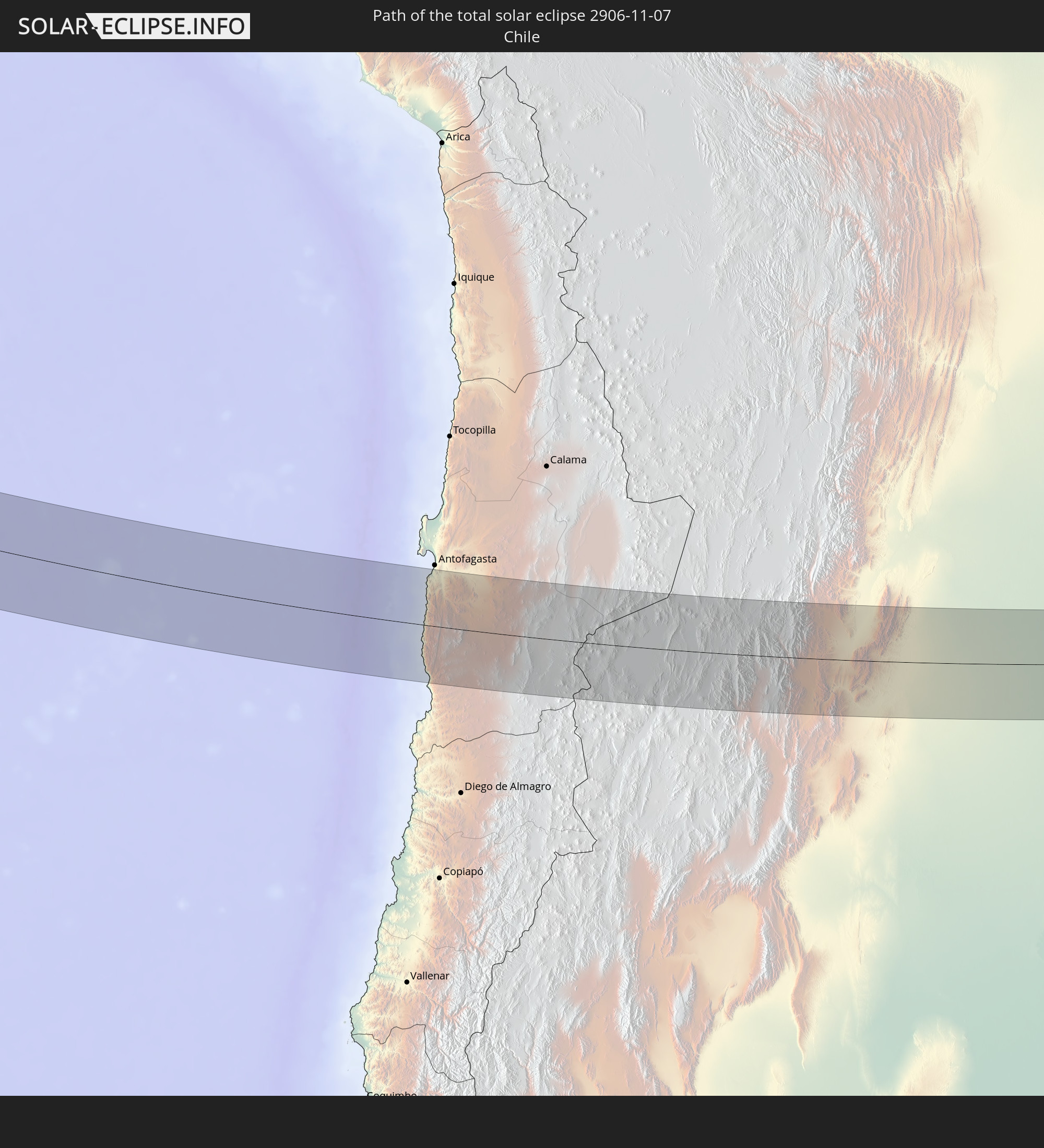 Chile
Chile
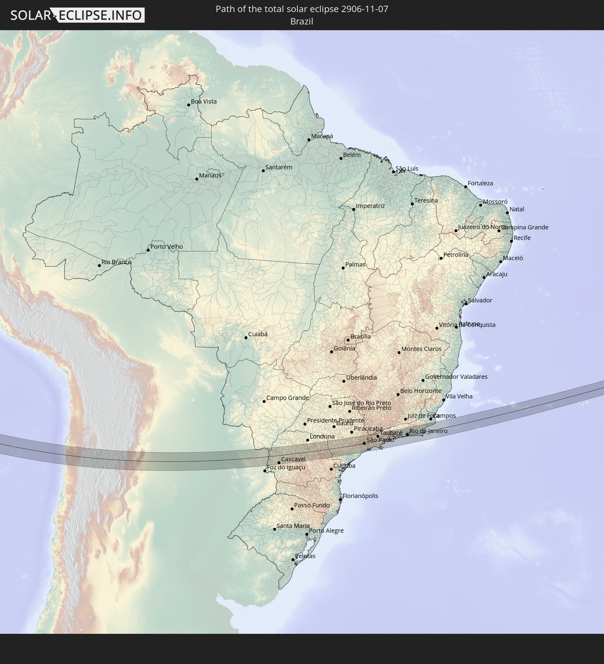 Brazil
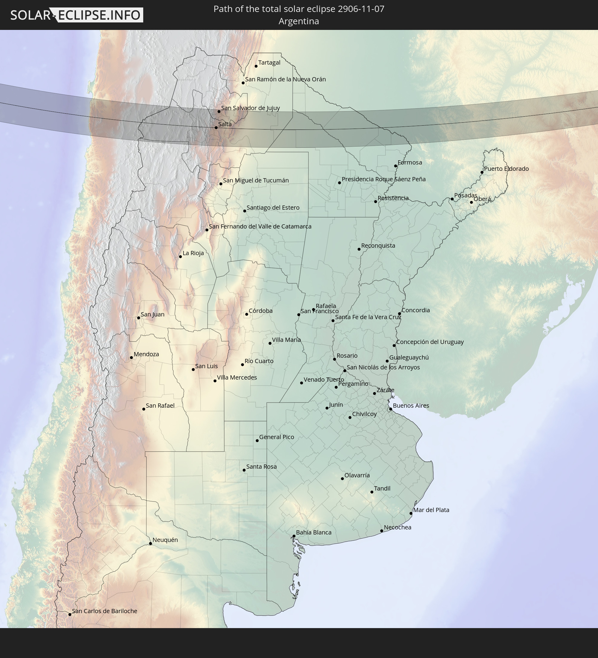 Argentina
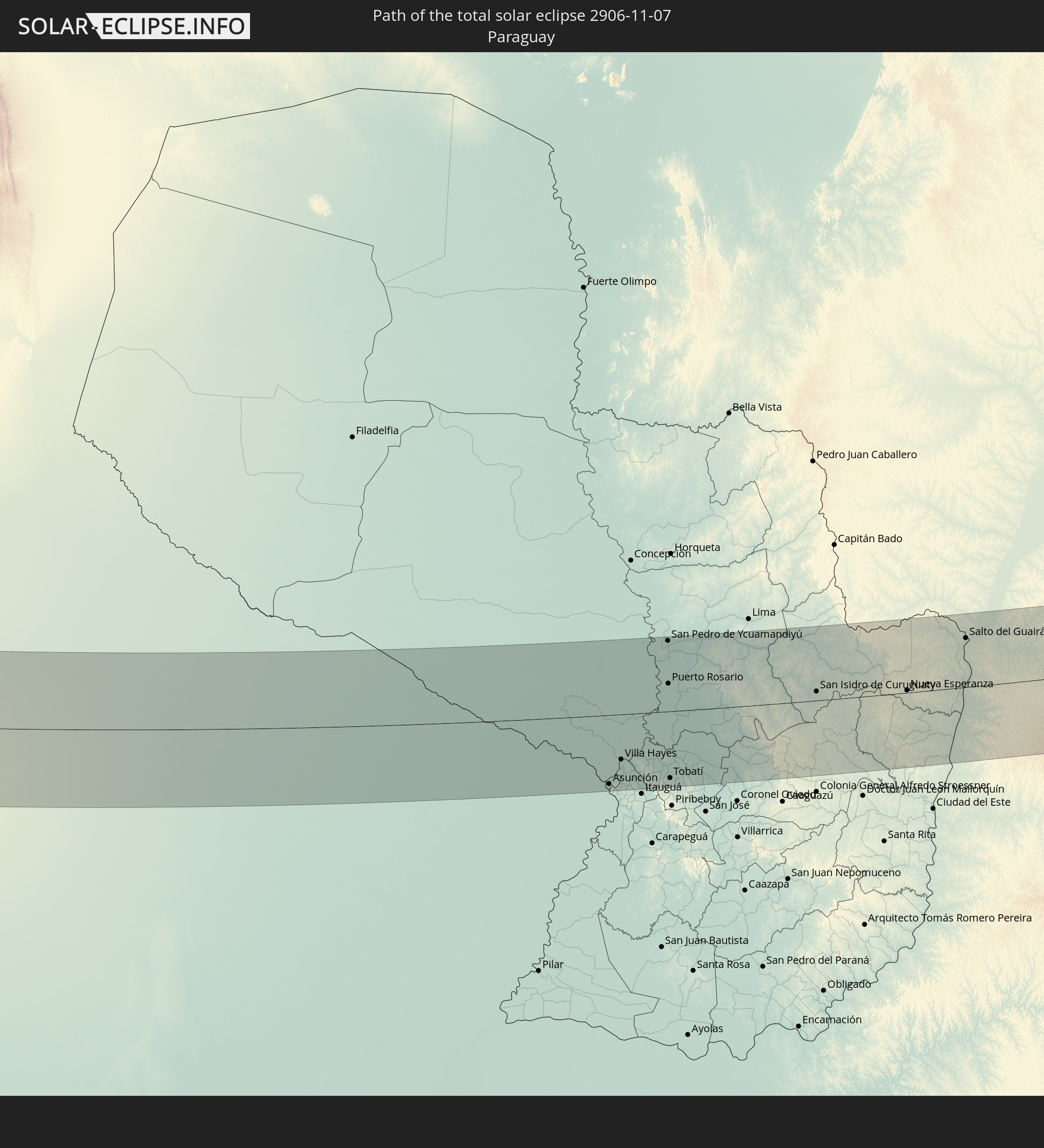 Paraguay
In den folgenden Ländern ist die Sonnenfinsternis partiell zu sehen
 Kiribati
 Cook Islands
 French Polynesia
 Pitcairn Islands
 Mexico
 Chile
Chile
 Guatemala
 Ecuador
 El Salvador
 Honduras
 Nicaragua
 Costa Rica
 Panama
 Colombia
 Peru
Peru
 Brazil
 Argentina
 Venezuela
 Bolivia
 Paraguay
 Falkland Islands
 Guyana
 Uruguay
 Suriname
 French Guiana
 South Georgia and the South Sandwich Islands
 Saint Helena, Ascension and Tristan da Cunha
How will be the weather during the total solar eclipse on 11/07/2906?
Where is the best place to see the total solar eclipse of 11/07/2906?
The following maps show the average cloud coverage for the day of the total solar eclipse.
With the help of these maps, it is possible to find the place along the eclipse path, which has the best
chance of a cloudless sky.
Nevertheless, you should consider local circumstances and inform about the weather of your chosen
observation site.
The data is provided by NASAs satellites
AQUA and TERRA.
The cloud maps are averaged over a period of 19 years (2000 - 2019).


Detailed country maps
 Chile
Chile
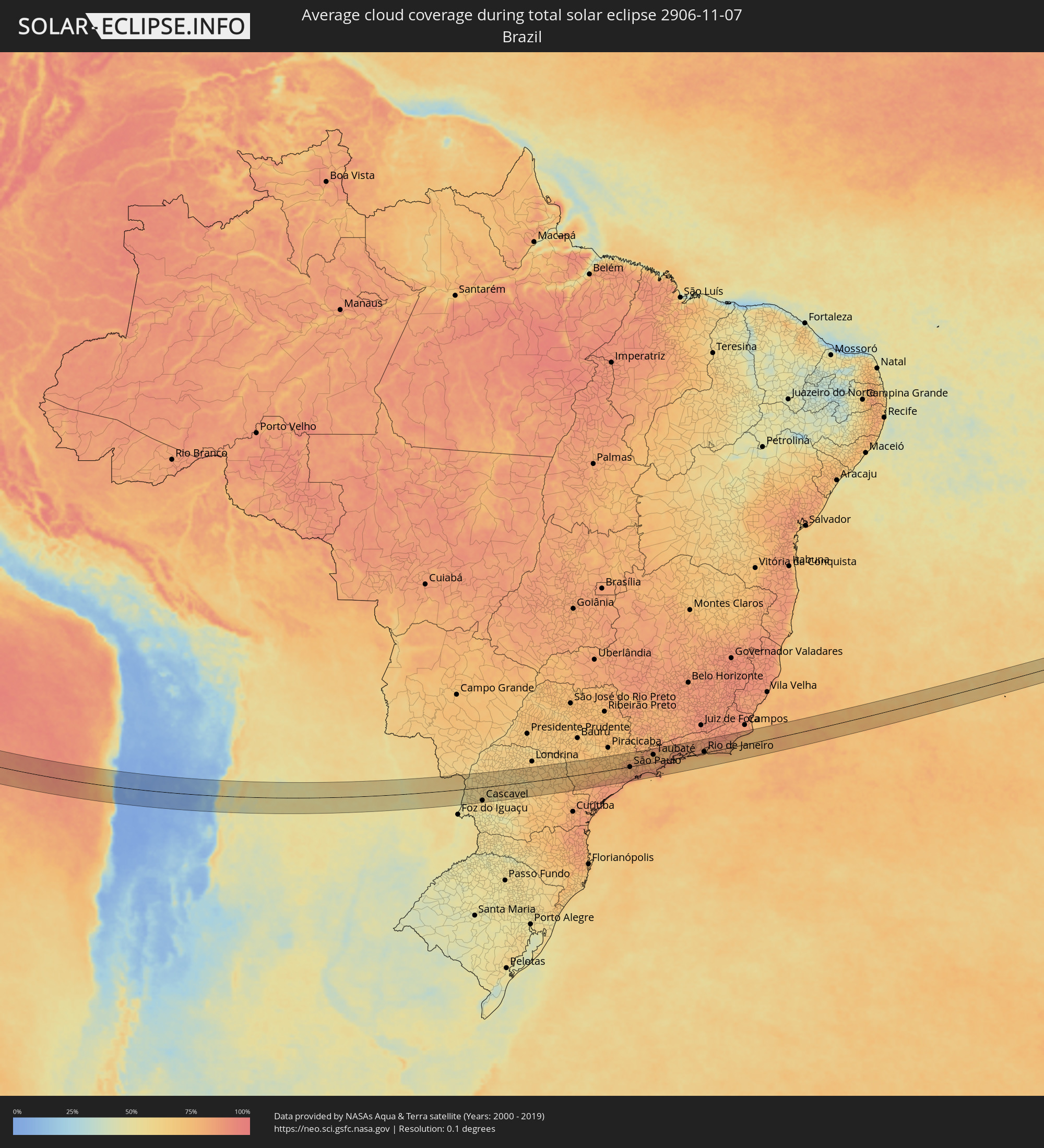 Brazil
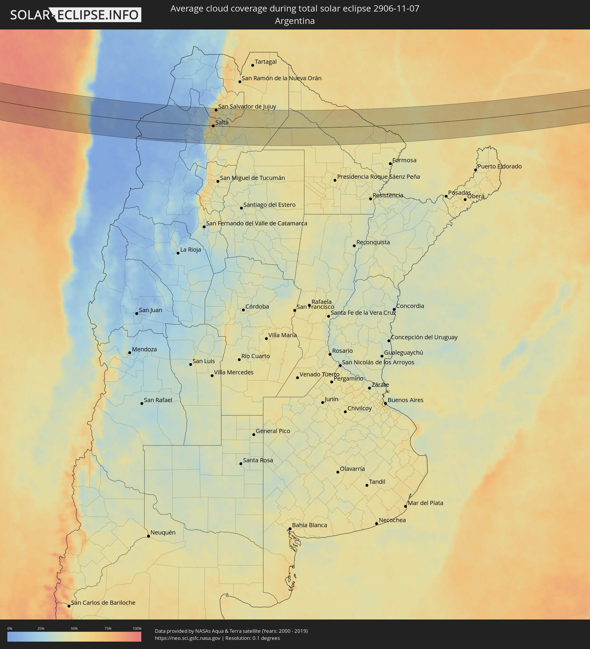 Argentina
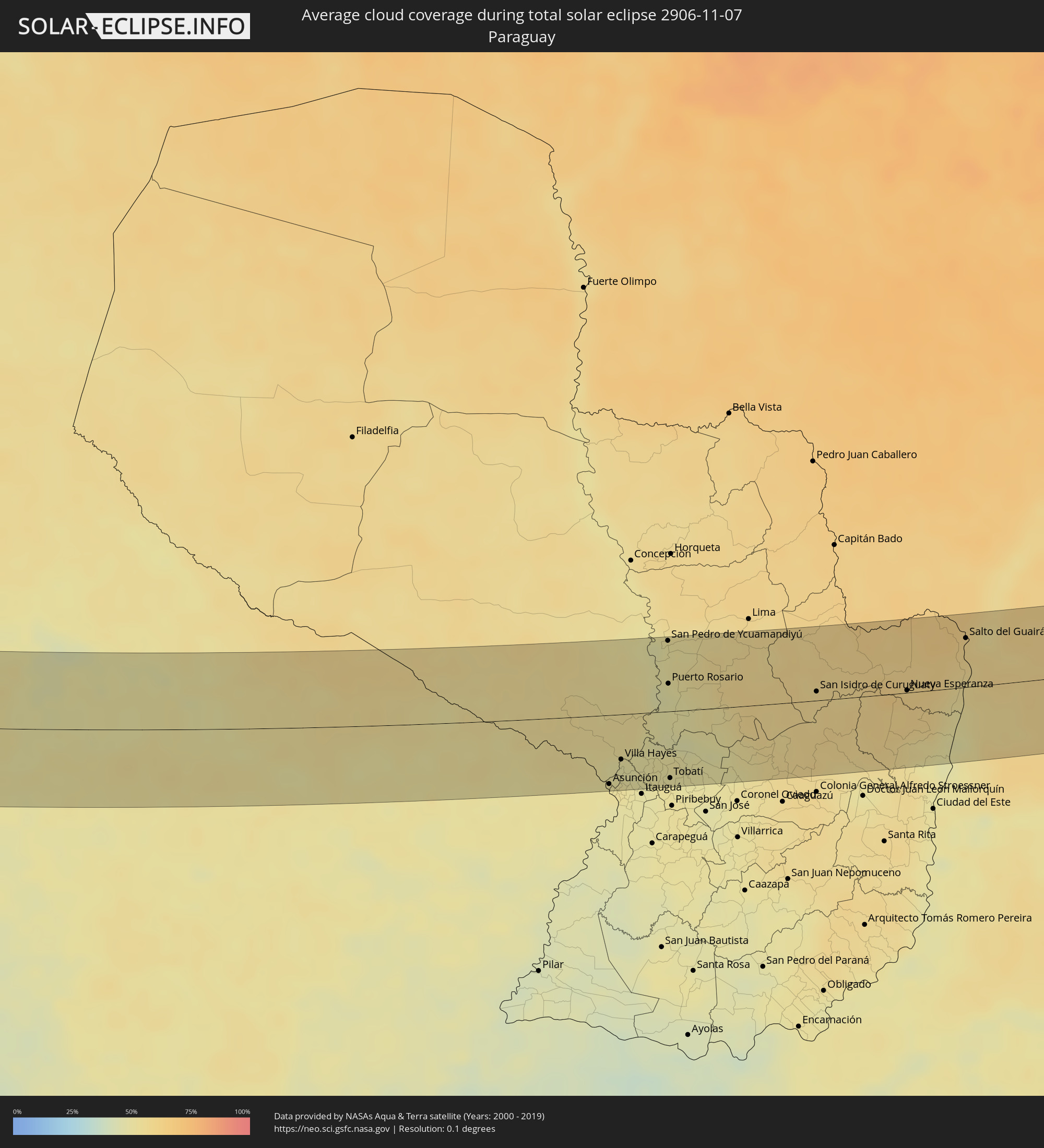 Paraguay
Cities inside the path of the eclipse
The following table shows all locations with a population of more than 5,000 inside the eclipse path. Cities which have more than 100,000 inhabitants are marked bold. A click at the locations opens a detailed map.
| City | Type | Eclipse duration | Local time of max. eclipse | Distance to central line | Ø Cloud coverage |
|
Chicoana, Salta Province
|
total | - | 15:05:48 UTC-03:00 | 37 km | 44% |
|
El Carril, Salta Province
|
total | - | 15:05:53 UTC-03:00 | 34 km | 44% |
|
Salta, Salta Province
|
total | - | 15:06:04 UTC-03:00 | 2 km | 48% |
|
San Salvador de Jujuy, Jujuy Province
|
total | - | 15:06:19 UTC-03:00 | 65 km | 52% |
|
Palpalá, Jujuy Province
|
total | - | 15:06:31 UTC-03:00 | 58 km | 47% |
|
San Pedro, Jujuy Province
|
total | - | 15:07:18 UTC-03:00 | 62 km | 46% |
|
Ingenio La Esperanza, Jujuy Province
|
total | - | 15:07:22 UTC-03:00 | 63 km | 44% |
|
El Galpón, Salta Province
|
total | - | 15:07:45 UTC-03:00 | 65 km | 45% |
|
Las Lajitas, Salta Province
|
total | - | 15:08:40 UTC-03:00 | 14 km | 48% |
|
Joaquín V. González, Salta Province
|
total | - | 15:08:47 UTC-03:00 | 30 km | 47% |
|
El Quebrachal, Salta Province
|
total | - | 15:09:02 UTC-03:00 | 52 km | 46% |
|
Apolinario Saravia, Salta Province
|
total | - | 15:09:14 UTC-03:00 | 43 km | 49% |
|
Las Lomitas, Formosa Province
|
total | - | 15:16:23 UTC-03:00 | 13 km | 52% |
|
Ibarreta, Formosa Province
|
total | - | 15:17:44 UTC-03:00 | 45 km | 51% |
|
Comandante Fontana, Formosa Province
|
total | - | 15:18:03 UTC-03:00 | 59 km | 50% |
|
Clorinda, Formosa Province
|
total | - | 15:21:46 UTC-03:00 | 63 km | 49% |
|
Nanawa, Presidente Hayes
|
total | - | 15:21:52 UTC-03:00 | 61 km | 49% |
|
Asunción, Asunción
|
total | - | 15:21:55 UTC-03:00 | 65 km | 51% |
|
Lambaré, Central
|
total | - | 15:21:57 UTC-03:00 | 70 km | 51% |
|
Benjamín Aceval, Presidente Hayes
|
total | - | 15:22:08 UTC-03:00 | 28 km | 48% |
|
Colonia Mariano Roque Alonso, Central
|
total | - | 15:22:07 UTC-03:00 | 50 km | 50% |
|
Villa Hayes, Presidente Hayes
|
total | - | 15:22:11 UTC-03:00 | 42 km | 48% |
|
Fernando de la Mora, Central
|
total | - | 15:22:07 UTC-03:00 | 70 km | 51% |
|
San Lorenzo, Central
|
total | - | 15:22:08 UTC-03:00 | 70 km | 51% |
|
Limpio, Central
|
total | - | 15:22:14 UTC-03:00 | 51 km | 51% |
|
Areguá, Central
|
total | - | 15:22:22 UTC-03:00 | 68 km | 48% |
|
Emboscada, Cordillera
|
total | - | 15:22:29 UTC-03:00 | 50 km | 49% |
|
San Pedro de Ycuamandiyú, San Pedro
|
total | - | 15:23:17 UTC-03:00 | 67 km | 50% |
|
Puerto Rosario, San Pedro
|
total | - | 15:23:11 UTC-03:00 | 26 km | 47% |
|
Tobatí, Cordillera
|
total | - | 15:22:58 UTC-03:00 | 63 km | 50% |
|
San Isidro de Curuguaty, Canindeyú
|
total | - | 15:25:37 UTC-03:00 | 9 km | 57% |
|
Nueva Esperanza, Canindeyú
|
total | - | 15:27:04 UTC-03:00 | 2 km | 61% |
|
Salto del Guairá, Canindeyú
|
total | - | 15:28:10 UTC-03:00 | 46 km | 59% |
|
Marechal Cândido Rondon, Paraná
|
total | - | 15:28:23 UTC-03:00 | 11 km | 55% |
|
Toledo, Paraná
|
total | - | 15:28:50 UTC-03:00 | 32 km | 56% |
|
Cascavel, Paraná
|
total | - | 15:29:12 UTC-03:00 | 61 km | 60% |
|
Umuarama, Paraná
|
total | - | 15:29:53 UTC-03:00 | 69 km | 61% |
|
Campo Mourão, Paraná
|
total | - | 15:31:17 UTC-03:00 | 27 km | 62% |
|
Telêmaco Borba, Paraná
|
total | - | 15:33:48 UTC-03:00 | 26 km | 67% |
|
Jaguariaíva, Paraná
|
total | - | 15:35:07 UTC-03:00 | 30 km | 72% |
|
Itararé, São Paulo
|
total | - | 15:35:43 UTC-03:00 | 21 km | 74% |
|
Itapeva, São Paulo
|
total | - | 15:36:24 UTC-03:00 | 14 km | 75% |
|
Capâo Bonito, São Paulo
|
total | - | 15:37:05 UTC-03:00 | 25 km | 77% |
|
Itapetininga, São Paulo
|
total | - | 15:37:41 UTC-03:00 | 16 km | 77% |
|
Tatuí, São Paulo
|
total | - | 15:38:03 UTC-03:00 | 39 km | 73% |
|
Cerquilho, São Paulo
|
total | - | 15:38:18 UTC-03:00 | 58 km | 71% |
|
Boituva, São Paulo
|
total | - | 15:38:20 UTC-03:00 | 44 km | 72% |
|
Salto de Pirapora, São Paulo
|
total | - | 15:38:17 UTC-03:00 | 2 km | 73% |
|
Porto Feliz, São Paulo
|
total | - | 15:38:33 UTC-03:00 | 49 km | 73% |
|
Sorocaba, São Paulo
|
total | - | 15:38:30 UTC-03:00 | 16 km | 75% |
|
Itu, São Paulo
|
total | - | 15:38:49 UTC-03:00 | 40 km | 72% |
|
Indaiatuba, São Paulo
|
total | - | 15:39:01 UTC-03:00 | 58 km | 70% |
|
São Roque, São Paulo
|
total | - | 15:38:54 UTC-03:00 | 8 km | 77% |
|
Cabreúva, São Paulo
|
total | - | 15:39:01 UTC-03:00 | 32 km | 75% |
|
Cotia, São Paulo
|
total | - | 15:39:08 UTC-03:00 | 4 km | 79% |
|
Santana de Parnaíba, São Paulo
|
total | - | 15:39:13 UTC-03:00 | 14 km | 80% |
|
Jundiaí, São Paulo
|
total | - | 15:39:23 UTC-03:00 | 41 km | 79% |
|
Itatiba, São Paulo
|
total | - | 15:39:32 UTC-03:00 | 60 km | 74% |
|
Embu Guaçu, São Paulo
|
total | - | 15:39:09 UTC-03:00 | 31 km | 82% |
|
Osasco, São Paulo
|
total | - | 15:39:20 UTC-03:00 | 2 km | 80% |
|
Francisco Morato, São Paulo
|
total | - | 15:39:31 UTC-03:00 | 29 km | 81% |
|
São Paulo, São Paulo
|
total | - | 15:39:31 UTC-03:00 | 3 km | 81% |
|
Mongaguá, São Paulo
|
total | - | 15:39:15 UTC-03:00 | 63 km | 79% |
|
Mairiporã, São Paulo
|
total | - | 15:39:41 UTC-03:00 | 22 km | 82% |
|
São Bernardo do Campo, São Paulo
|
total | - | 15:39:31 UTC-03:00 | 20 km | 80% |
|
Atibaia, São Paulo
|
total | - | 15:39:50 UTC-03:00 | 43 km | 78% |
|
Bragança Paulista, São Paulo
|
total | - | 15:39:55 UTC-03:00 | 61 km | 75% |
|
Ribeirão Pires, São Paulo
|
total | - | 15:39:42 UTC-03:00 | 24 km | 86% |
|
Itaquaquecetuba, São Paulo
|
total | - | 15:39:54 UTC-03:00 | 1 km | 81% |
|
Santos, São Paulo
|
total | - | 15:39:40 UTC-03:00 | 53 km | 79% |
|
Santa Isabel, São Paulo
|
total | - | 15:40:08 UTC-03:00 | 16 km | 81% |
|
Mogi das Cruzes, São Paulo
|
total | - | 15:40:04 UTC-03:00 | 8 km | 80% |
|
Bertioga, São Paulo
|
total | - | 15:39:57 UTC-03:00 | 45 km | 78% |
|
Jacareí, São Paulo
|
total | - | 15:40:27 UTC-03:00 | 12 km | 81% |
|
São José dos Campos, São Paulo
|
total | - | 15:40:37 UTC-03:00 | 25 km | 79% |
|
Caçapava, São Paulo
|
total | - | 15:40:52 UTC-03:00 | 30 km | 76% |
|
Taubaté, São Paulo
|
total | - | 15:41:05 UTC-03:00 | 35 km | 76% |
|
Caraguatatuba, São Paulo
|
total | - | 15:40:56 UTC-03:00 | 32 km | 84% |
|
São Sebastião, São Paulo
|
total | - | 15:40:52 UTC-03:00 | 48 km | 82% |
|
Guaratinguetá, São Paulo
|
total | - | 15:41:37 UTC-03:00 | 52 km | 75% |
|
Ubatuba, São Paulo
|
total | - | 15:41:26 UTC-03:00 | 18 km | 87% |
|
Angra dos Reis, Rio de Janeiro
|
total | - | 15:42:31 UTC-03:00 | 14 km | 82% |
|
Volta Redonda, Rio de Janeiro
|
total | - | 15:43:00 UTC-03:00 | 63 km | 83% |
|
Barra do Piraí, Rio de Janeiro
|
total | - | 15:43:20 UTC-03:00 | 64 km | 81% |
|
Itaguaí, Rio de Janeiro
|
total | - | 15:43:11 UTC-03:00 | 21 km | 78% |
|
Japeri, Rio de Janeiro
|
total | - | 15:43:26 UTC-03:00 | 41 km | 83% |
|
Nova Iguaçu, Rio de Janeiro
|
total | - | 15:43:35 UTC-03:00 | 25 km | 83% |
|
Rio de Janeiro, Rio de Janeiro
|
total | - | 15:43:46 UTC-03:00 | 4 km | 76% |
|
Petrópolis, Rio de Janeiro
|
total | - | 15:44:01 UTC-03:00 | 47 km | 85% |
|
Teresópolis, Rio de Janeiro
|
total | - | 15:44:16 UTC-03:00 | 52 km | 88% |
|
Itaboraí, Rio de Janeiro
|
total | - | 15:44:13 UTC-03:00 | 14 km | 82% |
|
Maricá, Rio de Janeiro
|
total | - | 15:44:10 UTC-03:00 | 6 km | 75% |
|
Cachoeiras de Macacu, Rio de Janeiro
|
total | - | 15:44:35 UTC-03:00 | 41 km | 84% |
|
Rio Bonito, Rio de Janeiro
|
total | - | 15:44:30 UTC-03:00 | 13 km | 84% |
|
Nova Friburgo, Rio de Janeiro
|
total | - | 15:44:48 UTC-03:00 | 58 km | 91% |
|
Saquarema, Rio de Janeiro
|
total | - | 15:44:29 UTC-03:00 | 12 km | 78% |
|
Araruama, Rio de Janeiro
|
total | - | 15:44:41 UTC-03:00 | 10 km | 78% |
|
Cabo Frio, Rio de Janeiro
|
total | - | 15:44:59 UTC-03:00 | 18 km | 74% |
|
Rio das Ostras, Rio de Janeiro
|
total | - | 15:45:16 UTC-03:00 | 19 km | 76% |
|
Macaé, Rio de Janeiro
|
total | - | 15:45:30 UTC-03:00 | 33 km | 77% |