Total solar eclipse of 08/25/2929
| Day of week: | Thursday |
| Maximum duration of eclipse: | 03m37s |
| Maximum width of eclipse path: | 254 km |
| Saros cycle: | 179 |
| Coverage: | 100% |
| Magnitude: | 1.0515 |
| Gamma: | 0.7413 |
Wo kann man die Sonnenfinsternis vom 08/25/2929 sehen?

Die Sonnenfinsternis am 08/25/2929 kann man in 24 Ländern als partielle Sonnenfinsternis beobachten.
Der Finsternispfad verläuft durch 3 Länder. Nur in diesen Ländern ist sie als total Sonnenfinsternis zu sehen.
In den folgenden Ländern ist die Sonnenfinsternis total zu sehen
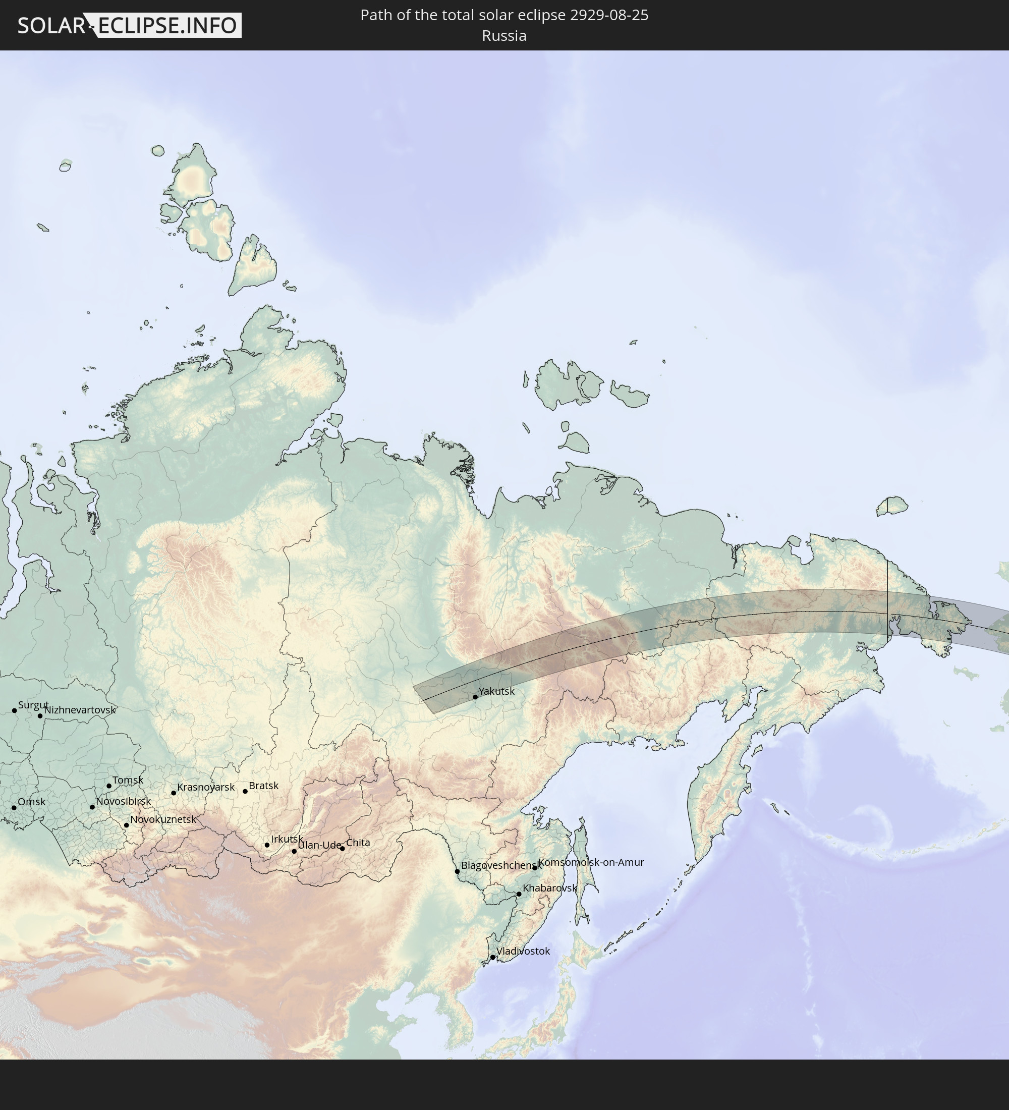 Russia
 United States
 Canada
In den folgenden Ländern ist die Sonnenfinsternis partiell zu sehen
 Russia
 United States
 United States Minor Outlying Islands
 Canada
 Mexico
 Greenland
 Guatemala
 Ecuador
 El Salvador
 Honduras
 Belize
 Nicaragua
 Costa Rica
 Cuba
Cuba
 Panama
 Colombia
 Cayman Islands
 The Bahamas
 Jamaica
 Haiti
Haiti
 Turks and Caicos Islands
 Saint Pierre and Miquelon
 Svalbard and Jan Mayen
 Japan
Japan
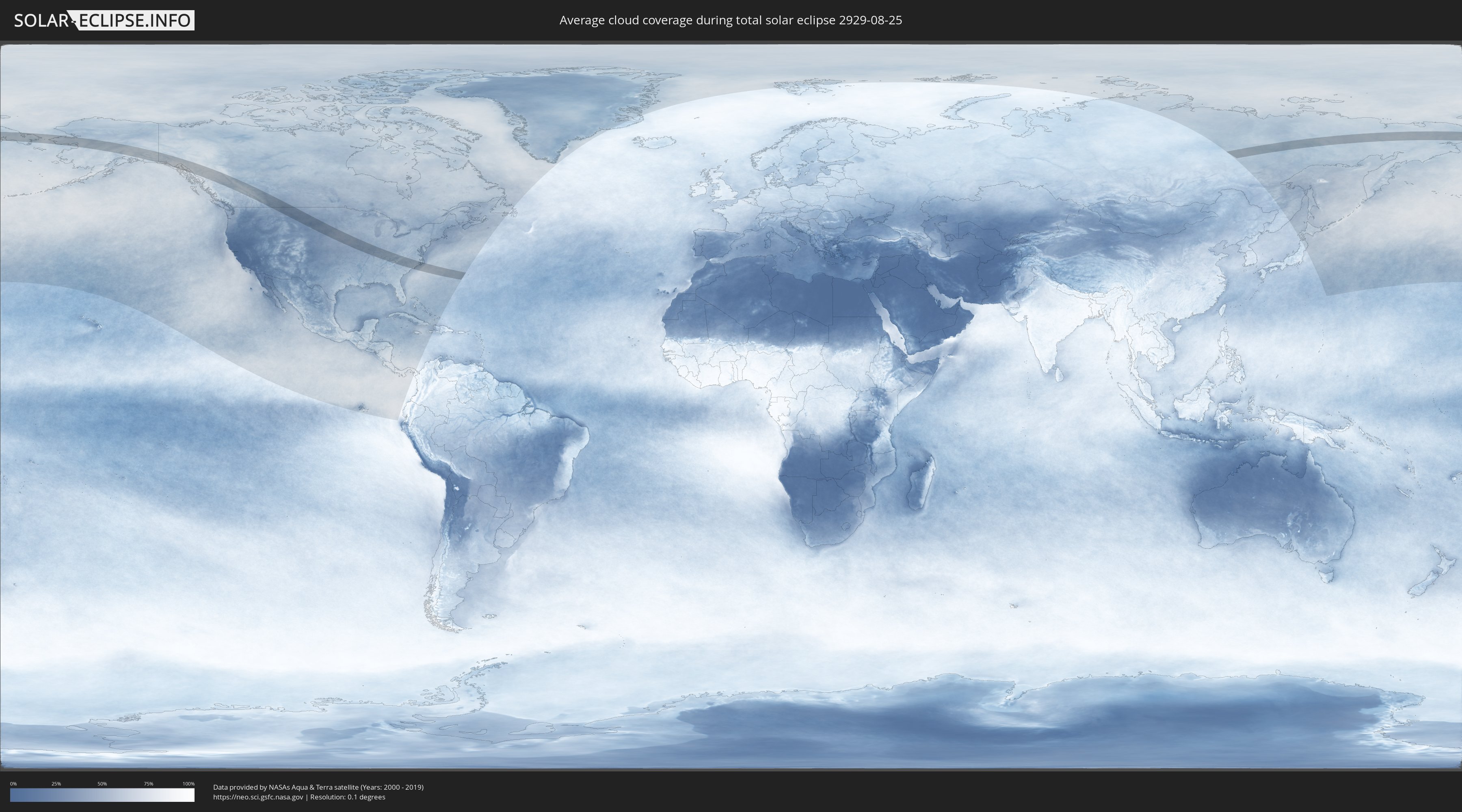
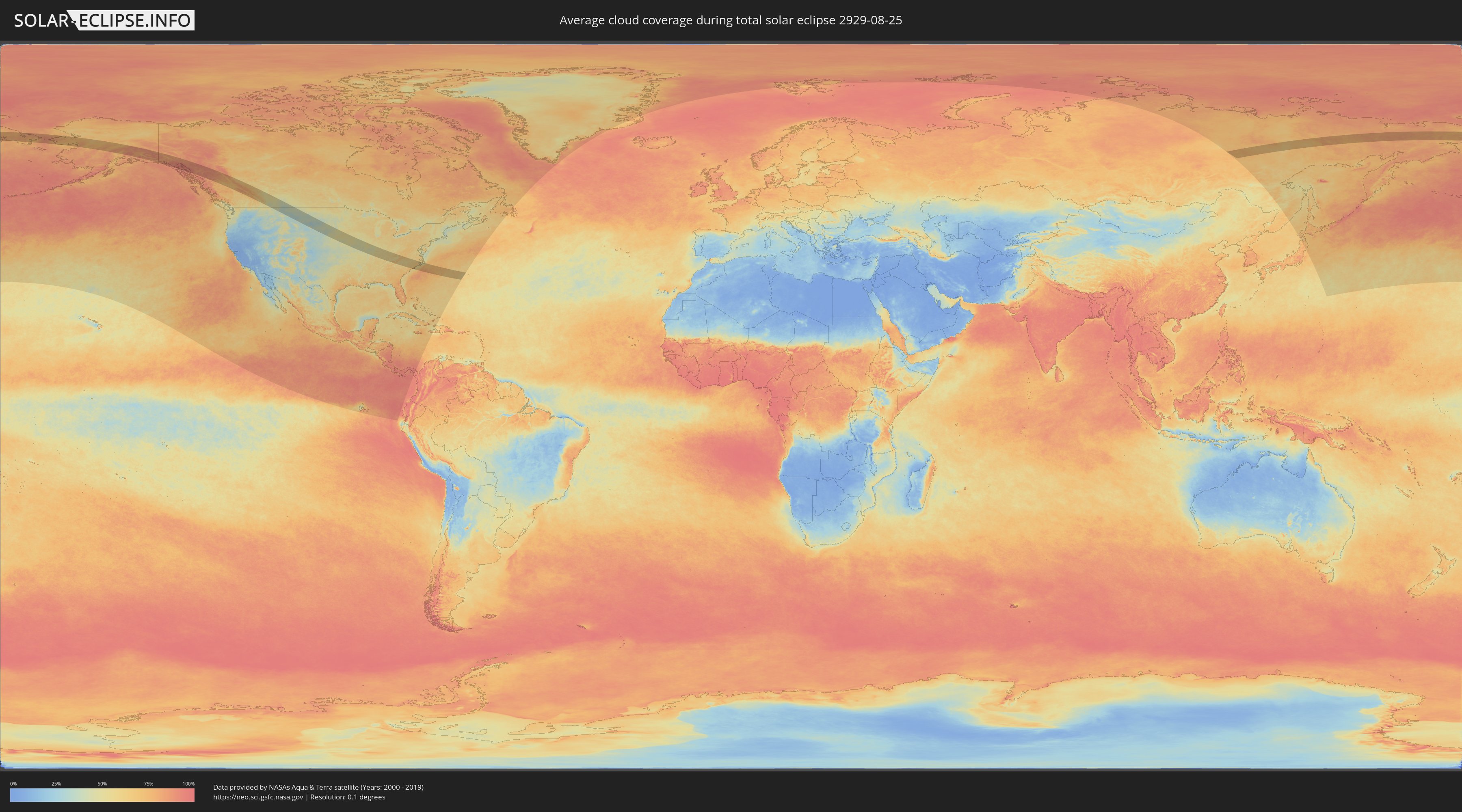
How will be the weather during the total solar eclipse on 08/25/2929?
Where is the best place to see the total solar eclipse of 08/25/2929?
The following maps show the average cloud coverage for the day of the total solar eclipse.
With the help of these maps, it is possible to find the place along the eclipse path, which has the best
chance of a cloudless sky.
Nevertheless, you should consider local circumstances and inform about the weather of your chosen
observation site.
The data is provided by NASAs satellites
AQUA and TERRA.
The cloud maps are averaged over a period of 19 years (2000 - 2019).
Detailed country maps
 Russia
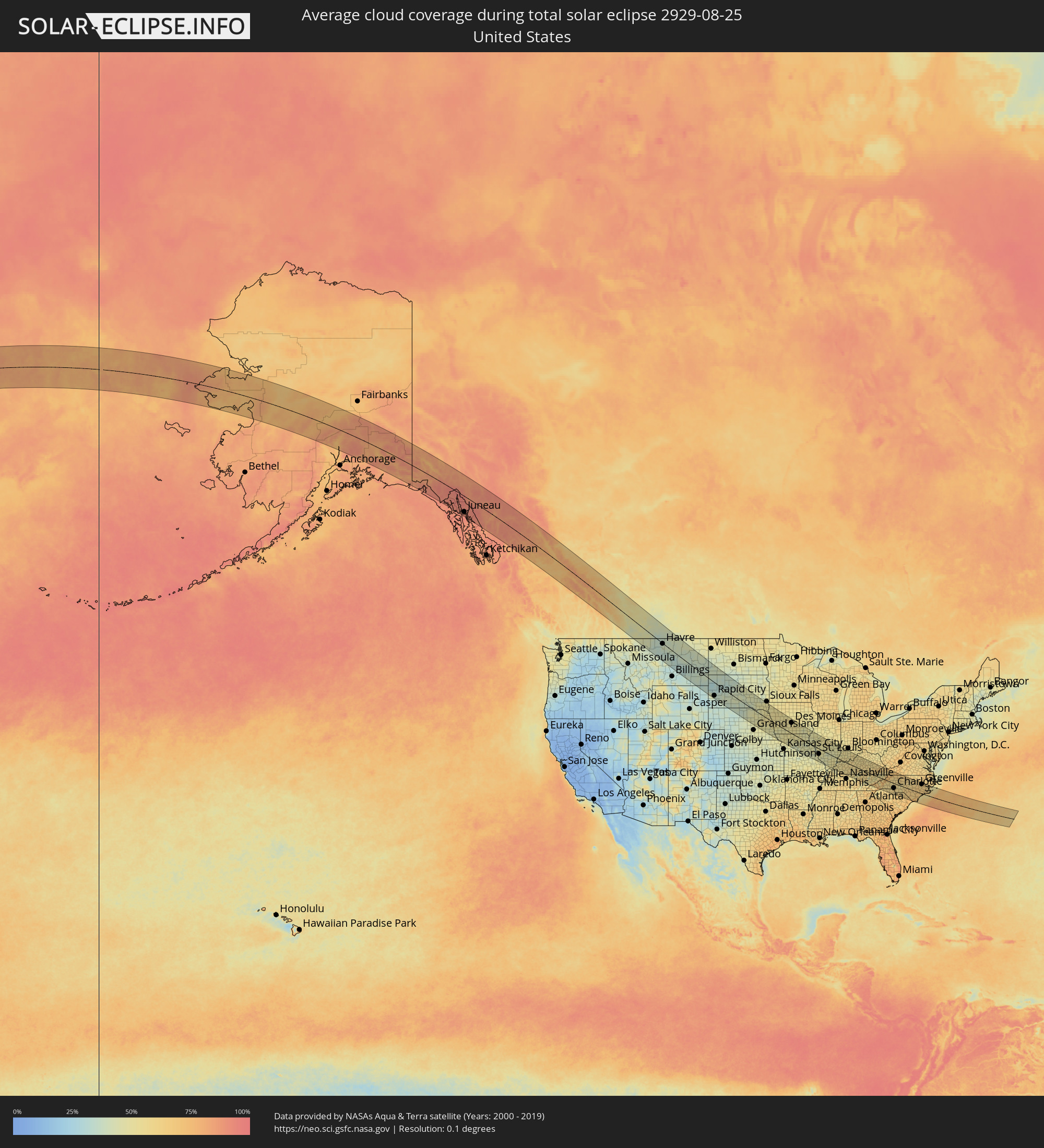 United States
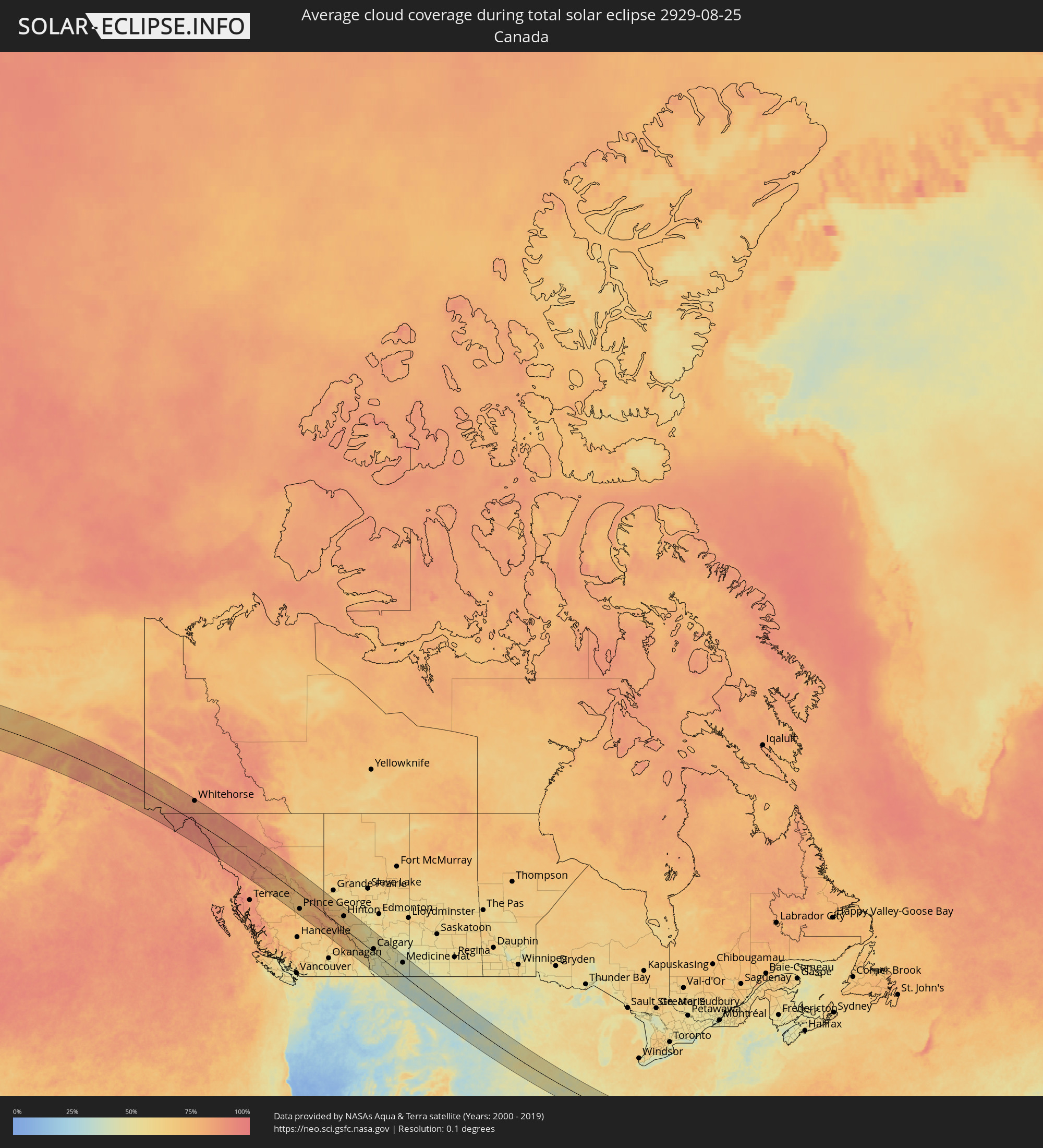 Canada
Cities inside the path of the eclipse
The following table shows all locations with a population of more than 5,000 inside the eclipse path. Cities which have more than 100,000 inhabitants are marked bold. A click at the locations opens a detailed map.
| City | Type | Eclipse duration | Local time of max. eclipse | Distance to central line | Ø Cloud coverage |
|
Whitehorse, Yukon
|
total | - | 13:25:47 UTC-08:00 | 114 km | 84% |
|
Juneau, Alaska
|
total | - | 12:28:15 UTC-09:00 | 95 km | 90% |
|
Prince George, British Columbia
|
total | - | 13:46:34 UTC-08:00 | 87 km | 71% |
|
Hinton, Alberta
|
total | - | 14:53:05 UTC-07:00 | 78 km | 66% |
|
Banff, Alberta
|
total | - | 14:58:40 UTC-07:00 | 39 km | 62% |
|
Canmore, Alberta
|
total | - | 14:59:03 UTC-07:00 | 33 km | 61% |
|
Rocky Mountain House, Alberta
|
total | - | 14:57:30 UTC-07:00 | 100 km | 48% |
|
Cochrane, Alberta
|
total | - | 14:59:50 UTC-07:00 | 17 km | 49% |
|
Olds, Alberta
|
total | - | 14:59:16 UTC-07:00 | 84 km | 53% |
|
Sylvan Lake, Alberta
|
total | - | 14:58:26 UTC-07:00 | 131 km | 55% |
|
Calgary, Alberta
|
total | - | 15:00:27 UTC-07:00 | 29 km | 50% |
|
Airdrie, Alberta
|
total | - | 15:00:06 UTC-07:00 | 44 km | 53% |
|
Okotoks, Alberta
|
total | - | 15:01:05 UTC-07:00 | 6 km | 48% |
|
High River, Alberta
|
total | - | 15:01:26 UTC-07:00 | 24 km | 46% |
|
Strathmore, Alberta
|
total | - | 15:01:11 UTC-07:00 | 53 km | 51% |
|
Lethbridge, Alberta
|
total | - | 15:03:59 UTC-07:00 | 43 km | 45% |
|
Coaldale, Alberta
|
total | - | 15:04:10 UTC-07:00 | 35 km | 48% |
|
Taber, Alberta
|
total | - | 15:04:32 UTC-07:00 | 11 km | 47% |
|
Brooks, Alberta
|
total | - | 15:03:29 UTC-07:00 | 76 km | 50% |
|
Medicine Hat, Alberta
|
total | - | 15:05:36 UTC-07:00 | 83 km | 43% |
|
Rapid City, South Dakota
|
total | - | 15:22:51 UTC-07:00 | 106 km | 38% |
|
Lincoln, Nebraska
|
total | - | 16:33:31 UTC-06:00 | 114 km | 47% |
|
Fremont, Nebraska
|
total | - | 16:32:30 UTC-06:00 | 51 km | 48% |
|
Sioux City, Iowa
|
total | - | 16:30:41 UTC-06:00 | 62 km | 51% |
|
Omaha, Nebraska
|
total | - | 16:33:10 UTC-06:00 | 43 km | 51% |
|
Des Moines, Iowa
|
total | - | 16:33:55 UTC-06:00 | 97 km | 53% |
|
Columbia, Missouri
|
total | - | 16:39:12 UTC-06:00 | 109 km | 48% |
|
Quincy, Illinois
|
total | - | 16:37:57 UTC-06:00 | 29 km | 45% |
|
O'Fallon, Missouri
|
total | - | 16:40:13 UTC-06:00 | 53 km | 47% |
|
Chesterfield, Missouri
|
total | - | 16:40:31 UTC-06:00 | 66 km | 47% |
|
Saint Charles, Missouri
|
total | - | 16:40:21 UTC-06:00 | 51 km | 49% |
|
Kirkwood, Missouri
|
total | - | 16:40:44 UTC-06:00 | 63 km | 50% |
|
Oakville, Missouri
|
total | - | 16:40:58 UTC-06:00 | 70 km | 45% |
|
St. Louis, Missouri
|
total | - | 16:40:45 UTC-06:00 | 51 km | 47% |
|
Upper Alton, Illinois
|
total | - | 16:40:17 UTC-06:00 | 21 km | 47% |
|
Belleville, Illinois
|
total | - | 16:41:01 UTC-06:00 | 56 km | 47% |
|
Springfield, Illinois
|
total | - | 16:38:59 UTC-06:00 | 89 km | 50% |
|
Decatur, Illinois
|
total | - | 16:39:12 UTC-06:00 | 120 km | 52% |
|
Henderson, Kentucky
|
total | - | 16:43:06 UTC-06:00 | 26 km | 53% |
|
Evansville, Indiana
|
total | - | 16:42:53 UTC-06:00 | 10 km | 49% |
|
Hopkinsville, Kentucky
|
total | - | 16:44:44 UTC-06:00 | 119 km | 59% |
|
Owensboro, Kentucky
|
total | - | 16:43:22 UTC-06:00 | 14 km | 55% |
|
Bowling Green, Kentucky
|
total | - | 16:44:53 UTC-06:00 | 68 km | 59% |
|
Elizabethtown, Kentucky
|
total | - | 17:43:54 UTC-05:00 | 26 km | 58% |
|
Louisville, Kentucky
|
total | - | 17:43:00 UTC-05:00 | 88 km | 56% |
|
Jeffersontown, Kentucky
|
total | - | 17:43:10 UTC-05:00 | 87 km | 57% |
|
Cookeville, Tennessee
|
total | - | 16:46:30 UTC-06:00 | 116 km | 57% |
|
Nicholasville, Kentucky
|
total | - | 17:43:58 UTC-05:00 | 92 km | 58% |
|
Lexington-Fayette, Kentucky
|
total | - | 17:43:43 UTC-05:00 | 114 km | 57% |
|
Richmond, Kentucky
|
total | - | 17:44:15 UTC-05:00 | 91 km | 57% |
|
Oak Ridge, Tennessee
|
total | - | 17:47:04 UTC-05:00 | 88 km | 51% |
|
Maryville, Tennessee
|
total | - | 17:47:33 UTC-05:00 | 102 km | 55% |
|
Knoxville, Tennessee
|
total | - | 17:47:14 UTC-05:00 | 80 km | 55% |
|
Morristown, Tennessee
|
total | - | 17:46:58 UTC-05:00 | 32 km | 57% |
|
Kingsport, Tennessee
|
total | - | 17:46:36 UTC-05:00 | 28 km | 54% |
|
Asheville, North Carolina
|
total | - | 17:48:06 UTC-05:00 | 69 km | 56% |
|
Johnson City, Tennessee
|
total | - | 17:47:01 UTC-05:00 | 11 km | 58% |
|
Bristol, Tennessee
|
total | - | 17:46:36 UTC-05:00 | 46 km | 52% |
|
Spartanburg, South Carolina
|
total | - | 17:49:14 UTC-05:00 | 115 km | 58% |
|
Hickory, North Carolina
|
total | - | 17:48:06 UTC-05:00 | 26 km | 57% |
|
Gastonia, North Carolina
|
total | - | 17:48:52 UTC-05:00 | 58 km | 59% |
|
Rock Hill, South Carolina
|
total | - | 17:49:25 UTC-05:00 | 89 km | 58% |
|
Charlotte, North Carolina
|
total | - | 17:48:58 UTC-05:00 | 52 km | 62% |
|
Huntersville, North Carolina
|
total | - | 17:48:41 UTC-05:00 | 38 km | 60% |
|
Mooresville, North Carolina
|
total | - | 17:48:25 UTC-05:00 | 26 km | 55% |
|
Indian Trail, North Carolina
|
total | - | 17:49:14 UTC-05:00 | 61 km | 61% |
|
Concord, North Carolina
|
total | - | 17:48:44 UTC-05:00 | 23 km | 59% |
|
Salisbury, North Carolina
|
total | - | 17:48:20 UTC-05:00 | 8 km | 58% |
|
Winston-Salem, North Carolina
|
total | - | 17:47:42 UTC-05:00 | 60 km | 62% |
|
High Point, North Carolina
|
total | - | 17:47:57 UTC-05:00 | 56 km | 63% |
|
Greensboro, North Carolina
|
total | - | 17:47:48 UTC-05:00 | 72 km | 64% |
|
Burlington, North Carolina
|
total | - | 17:47:49 UTC-05:00 | 88 km | 62% |
|
Sanford, North Carolina
|
total | - | 17:48:47 UTC-05:00 | 36 km | 62% |
|
Chapel Hill, North Carolina
|
total | - | 17:48:08 UTC-05:00 | 80 km | 59% |
|
Fort Bragg, North Carolina
|
total | - | 17:49:20 UTC-05:00 | 1 km | 66% |
|
Durham, North Carolina
|
total | - | 17:48:02 UTC-05:00 | 95 km | 61% |
|
Fayetteville, North Carolina
|
total | - | 17:49:28 UTC-05:00 | 15 km | 65% |
|
Apex, North Carolina
|
total | - | 17:48:26 UTC-05:00 | 67 km | 57% |
|
Raleigh, North Carolina
|
total | - | 17:48:24 UTC-05:00 | 77 km | 61% |
|
Wake Forest, North Carolina
|
total | - | 17:48:05 UTC-05:00 | 103 km | 61% |
|
Goldsboro, North Carolina
|
total | - | 17:49:02 UTC-05:00 | 60 km | 64% |
|
Wilmington, North Carolina
|
total | - | 17:50:48 UTC-05:00 | 67 km | 61% |
|
Wilson, North Carolina
|
total | - | 17:48:32 UTC-05:00 | 97 km | 61% |
|
Jacksonville, North Carolina
|
total | - | 17:50:02 UTC-05:00 | 8 km | 65% |
|
Greenville, North Carolina
|
total | - | 17:48:44 UTC-05:00 | 102 km | 67% |
|
New Bern, North Carolina
|
total | - | 17:49:31 UTC-05:00 | 61 km | 63% |
|
Berdigestyakh, Sakha
|
total | - | 05:32:12 UTC+09:00 | 43 km | 75% |
|
Namtsy, Sakha
|
total | - | 05:32:31 UTC+09:00 | 32 km | 71% |
|
Yakutsk, Sakha
|
total | - | 05:31:36 UTC+09:00 | 105 km | 72% |
|
Markha, Sakha
|
total | - | 05:31:42 UTC+09:00 | 96 km | 74% |
|
Zhatay, Sakha
|
total | - | 05:31:45 UTC+09:00 | 94 km | 71% |
|
Borogontsy, Sakha
|
total | - | 05:32:14 UTC+09:00 | 64 km | 70% |
|
Ust-Nera, Sakha
|
total | - | 06:34:24 UTC+10:00 | 39 km | 70% |