Annular solar eclipse of 01/09/2931
| Day of week: | Tuesday |
| Maximum duration of eclipse: | 06m52s |
| Maximum width of eclipse path: | 510 km |
| Saros cycle: | 156 |
| Coverage: | 93.7% |
| Magnitude: | 0.9369 |
| Gamma: | 0.8864 |
Wo kann man die Sonnenfinsternis vom 01/09/2931 sehen?

Die Sonnenfinsternis am 01/09/2931 kann man in 8 Ländern als partielle Sonnenfinsternis beobachten.
Der Finsternispfad verläuft durch 3 Länder. Nur in diesen Ländern ist sie als annular Sonnenfinsternis zu sehen.
In den folgenden Ländern ist die Sonnenfinsternis annular zu sehen
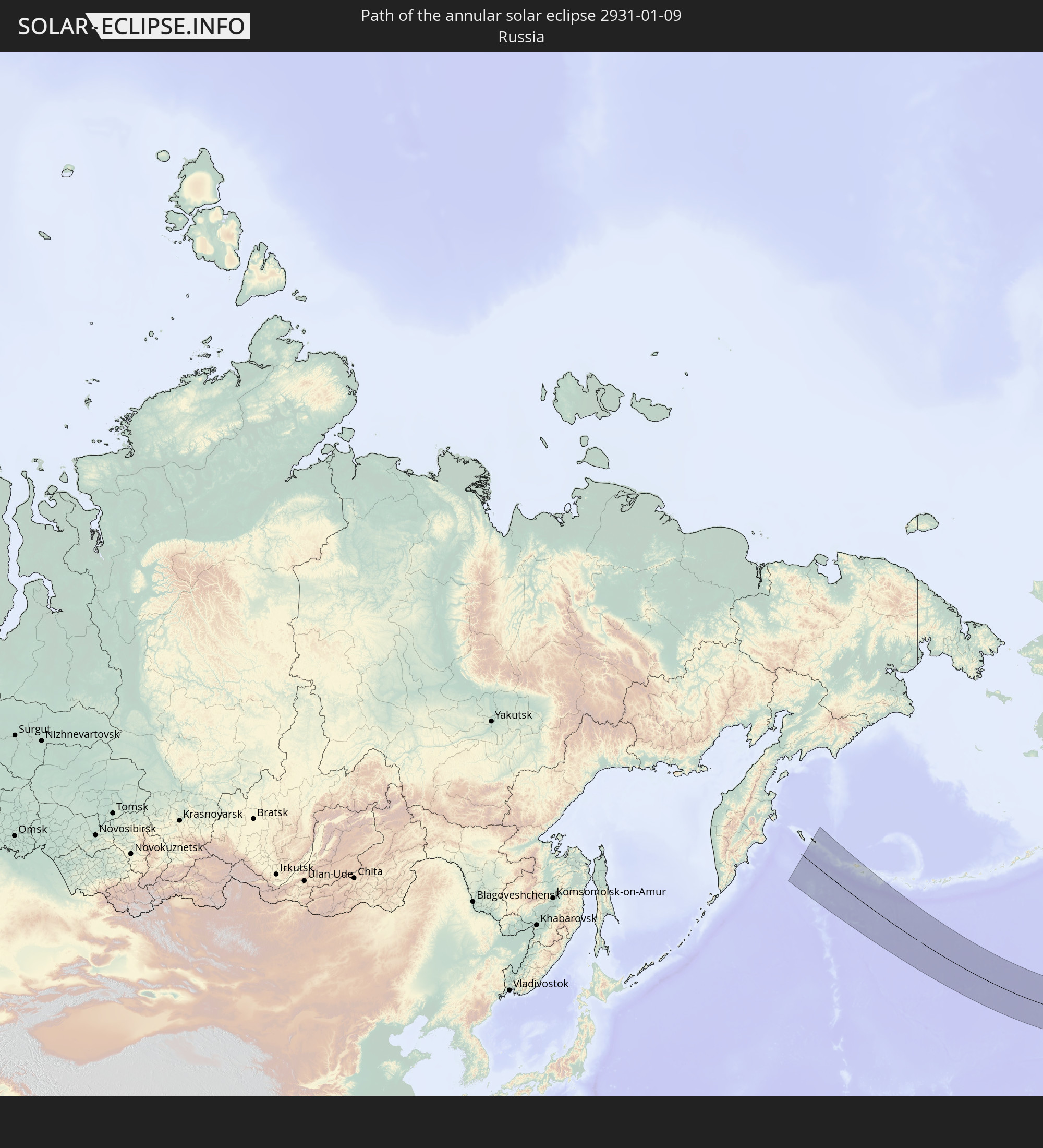 Russia
 United States
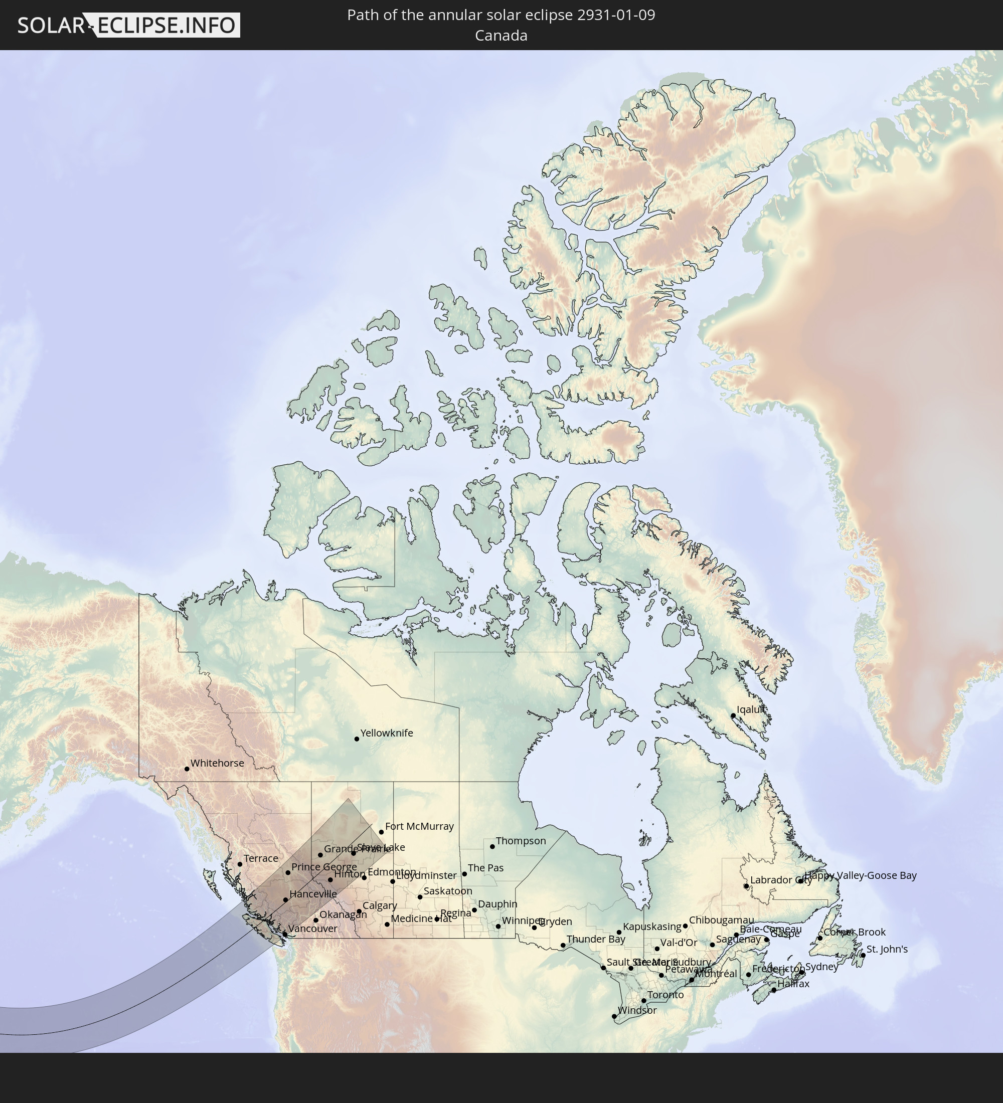 Canada
In den folgenden Ländern ist die Sonnenfinsternis partiell zu sehen


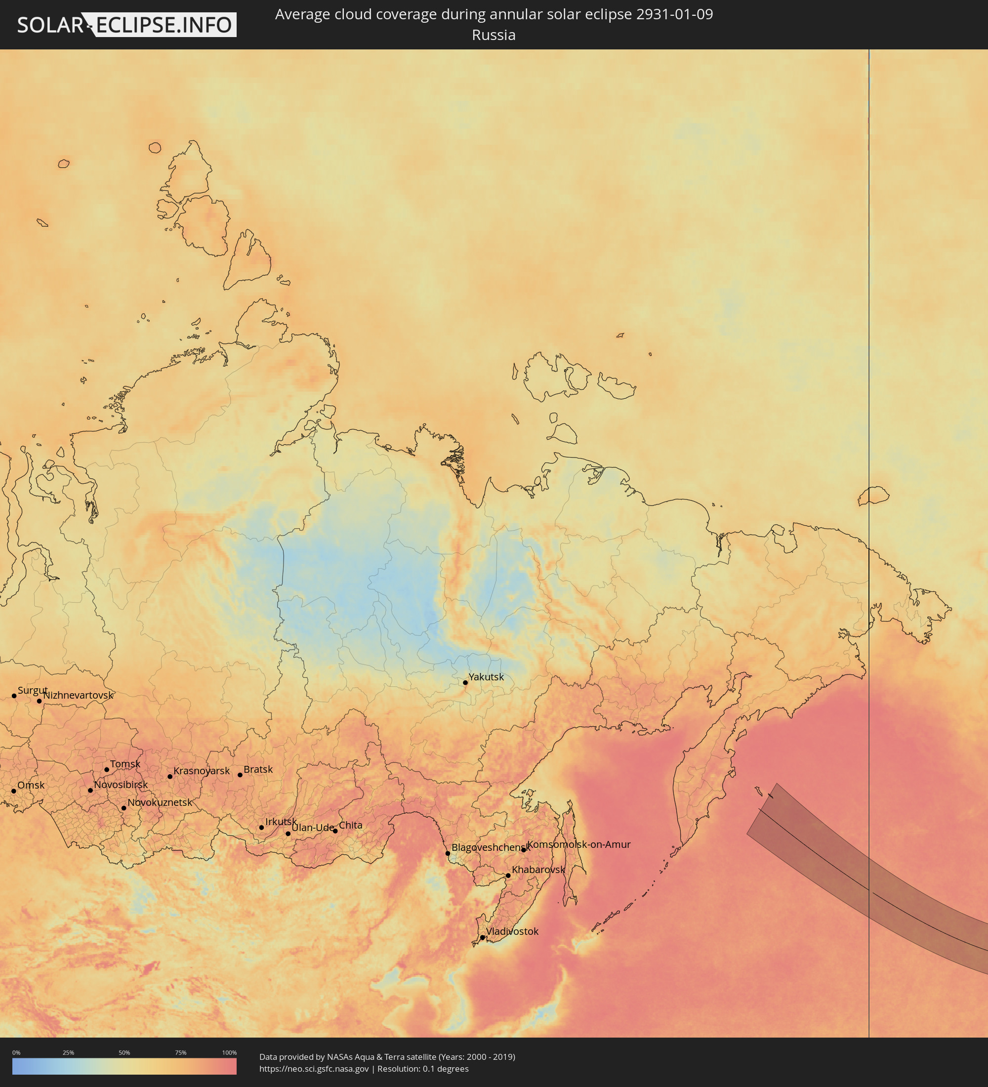
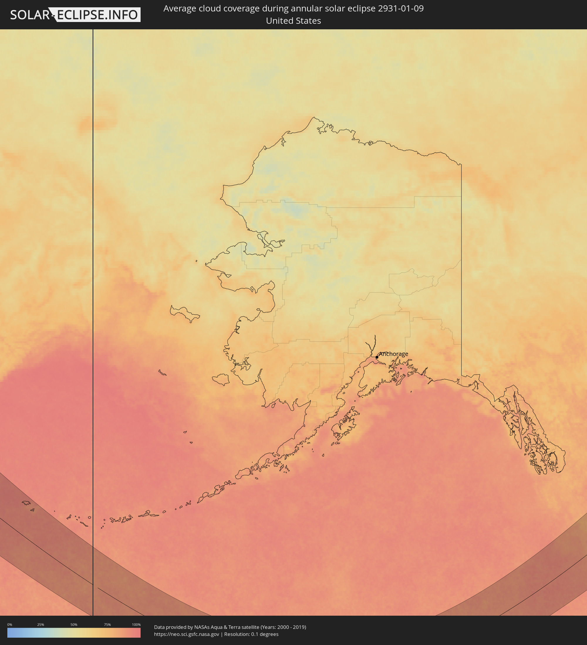
How will be the weather during the annular solar eclipse on 01/09/2931?
Where is the best place to see the annular solar eclipse of 01/09/2931?
The following maps show the average cloud coverage for the day of the annular solar eclipse.
With the help of these maps, it is possible to find the place along the eclipse path, which has the best
chance of a cloudless sky.
Nevertheless, you should consider local circumstances and inform about the weather of your chosen
observation site.
The data is provided by NASAs satellites
AQUA and TERRA.
The cloud maps are averaged over a period of 19 years (2000 - 2019).


Detailed country maps
 Russia
 United States
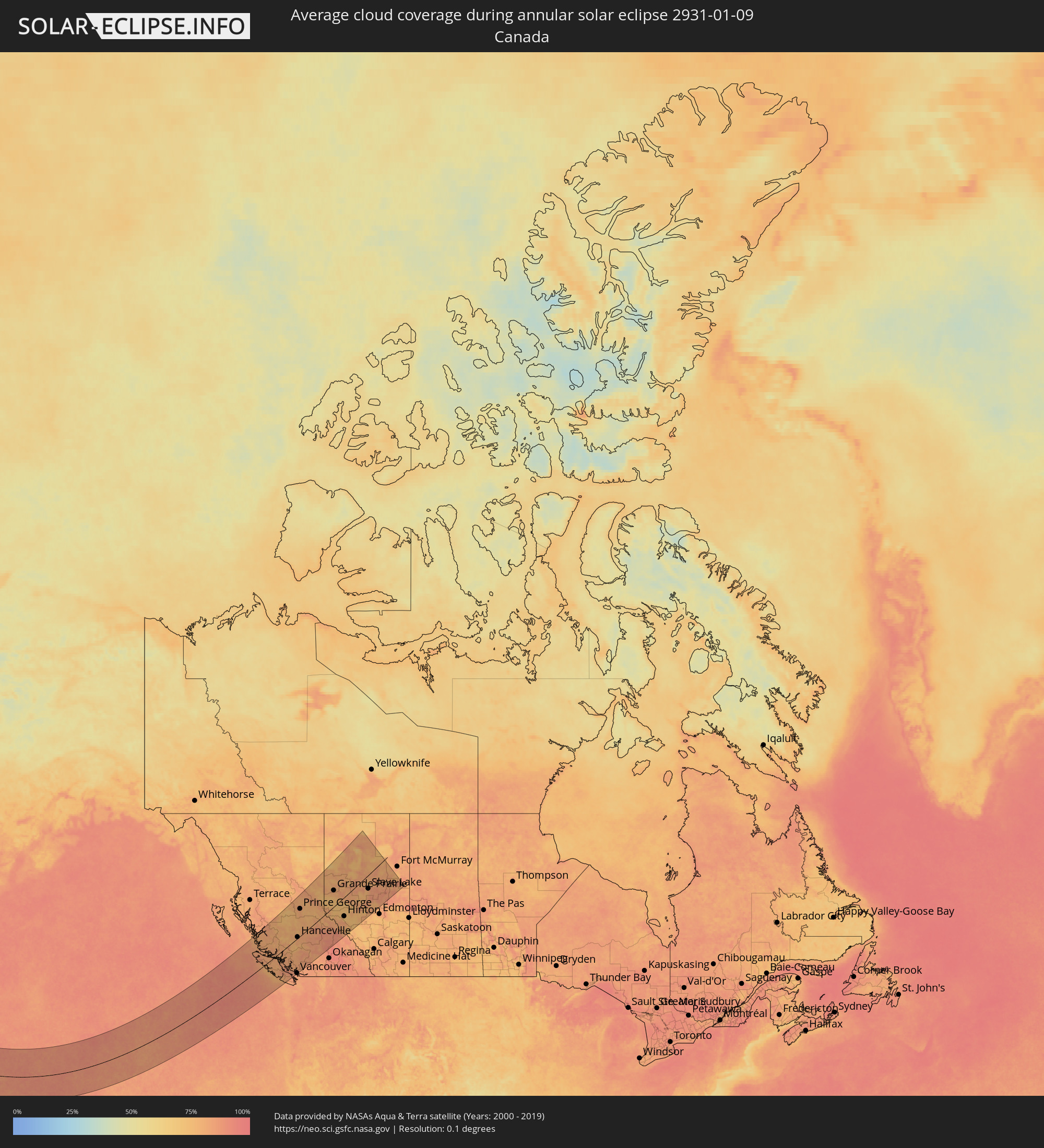 Canada
Cities inside the path of the eclipse
The following table shows all locations with a population of more than 5,000 inside the eclipse path. Cities which have more than 100,000 inhabitants are marked bold. A click at the locations opens a detailed map.
| City | Type | Eclipse duration | Local time of max. eclipse | Distance to central line | Ø Cloud coverage |
 Campbell River, British Columbia
|
annular | - | 14:56:11 UTC-08:00 | 59 km | 82% |
|
Courtenay, British Columbia
|
annular | - | 14:56:52 UTC-08:00 | 99 km | 83% |
|
Port Alberni, British Columbia
|
annular | - | 14:57:36 UTC-08:00 | 147 km | 85% |
|
Powell River, British Columbia
|
annular | - | 14:57:19 UTC-08:00 | 107 km | 84% |
|
Parksville, British Columbia
|
annular | - | 14:58:08 UTC-08:00 | 162 km | 86% |
|
Nanaimo, British Columbia
|
annular | - | 14:58:47 UTC-08:00 | 192 km | 86% |
|
Ladysmith, British Columbia
|
annular | - | 14:59:07 UTC-08:00 | 213 km | 85% |
|
Sechelt, British Columbia
|
annular | - | 14:58:40 UTC-08:00 | 173 km | 86% |
|
Gibsons, British Columbia
|
annular | - | 14:59:04 UTC-08:00 | 191 km | 85% |
|
West Vancouver, British Columbia
|
annular | - | 14:59:31 UTC-08:00 | 209 km | 83% |
|
West End, British Columbia
|
annular | - | 14:59:39 UTC-08:00 | 218 km | 85% |
|
Vancouver, British Columbia
|
annular | - | 14:59:42 UTC-08:00 | 221 km | 85% |
|
North Vancouver, British Columbia
|
annular | - | 14:59:42 UTC-08:00 | 218 km | 85% |
|
Hanceville, British Columbia
|
annular | - | 14:56:45 UTC-08:00 | 7 km | 82% |
|
Whistler, British Columbia
|
annular | - | 14:58:55 UTC-08:00 | 152 km | 81% |
|
Prince George, British Columbia
|
annular | - | 14:54:42 UTC-08:00 | 161 km | 83% |
|
Quesnel, British Columbia
|
annular | - | 14:56:08 UTC-08:00 | 71 km | 81% |
|
Williams Lake, British Columbia
|
annular | - | 14:57:31 UTC-08:00 | 15 km | 81% |
|
Kamloops, British Columbia
|
annular | - | 15:01:20 UTC-08:00 | 222 km | 87% |
|
Dawson Creek, British Columbia
|
annular | - | 15:55:03 UTC-07:00 | 201 km | 77% |
|
Grande Prairie, Alberta
|
annular | - | 15:57:14 UTC-07:00 | 90 km | 80% |
|
Hinton, Alberta
|
annular | - | 16:00:43 UTC-07:00 | 109 km | 74% |
|
Peace River, Alberta
|
annular | - | 15:57:13 UTC-07:00 | 112 km | 79% |
|
Edson, Alberta
|
annular | - | 16:01:34 UTC-07:00 | 143 km | 76% |
|
Whitecourt, Alberta
|
annular | - | 16:01:29 UTC-07:00 | 128 km | 82% |
|
Slave Lake, Alberta
|
annular | - | 16:00:44 UTC-07:00 | 74 km | 84% |
|
Westlock, Alberta
|
annular | - | 16:03:03 UTC-07:00 | 206 km | 78% |