Total solar eclipse of 08/06/2939
| Day of week: | Thursday |
| Maximum duration of eclipse: | 06m33s |
| Maximum width of eclipse path: | 250 km |
| Saros cycle: | 170 |
| Coverage: | 100% |
| Magnitude: | 1.0761 |
| Gamma: | -0.1702 |
Wo kann man die Sonnenfinsternis vom 08/06/2939 sehen?
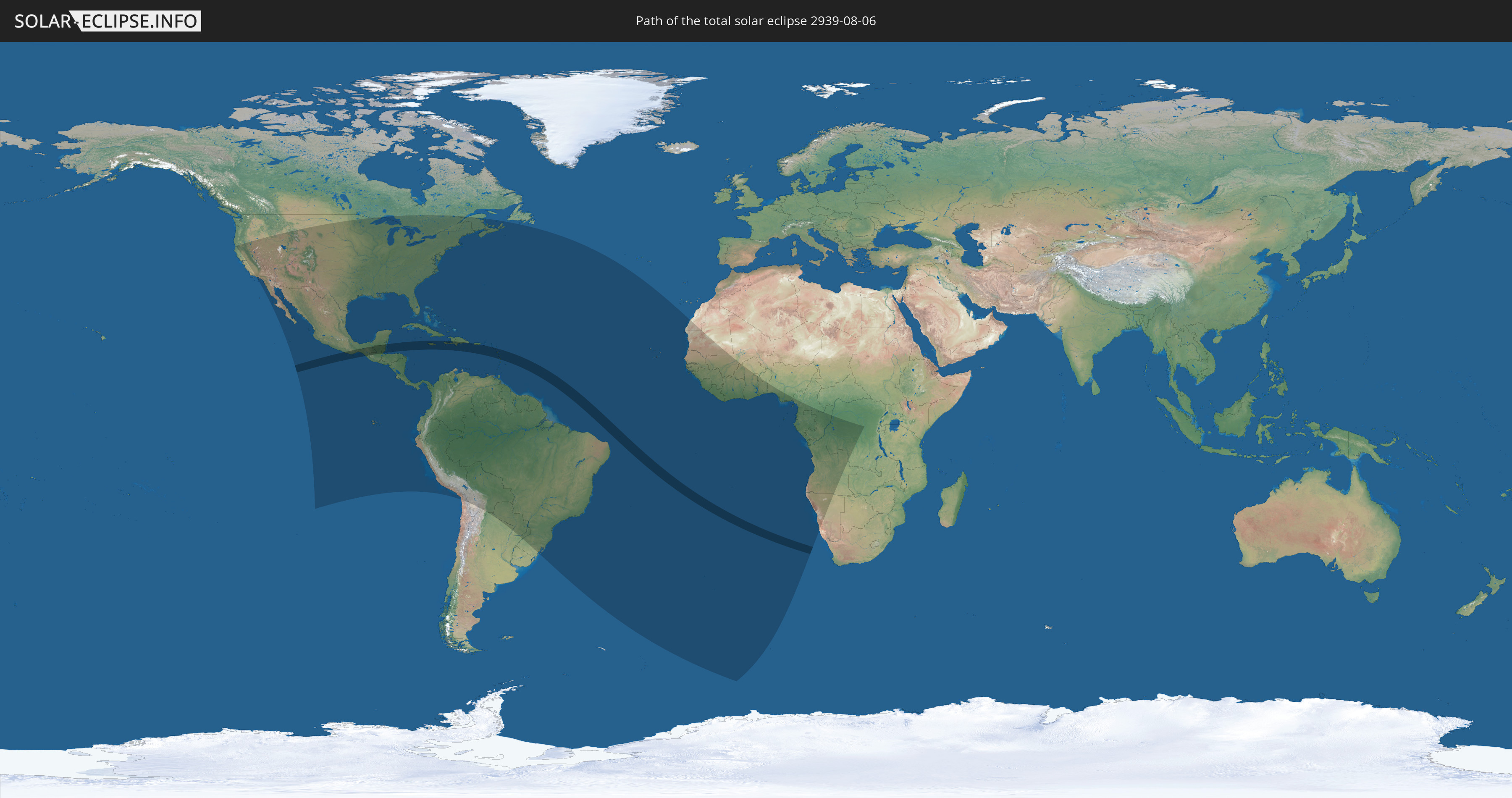
Die Sonnenfinsternis am 08/06/2939 kann man in 73 Ländern als partielle Sonnenfinsternis beobachten.
Der Finsternispfad verläuft durch 17 Länder. Nur in diesen Ländern ist sie als total Sonnenfinsternis zu sehen.
In den folgenden Ländern ist die Sonnenfinsternis total zu sehen
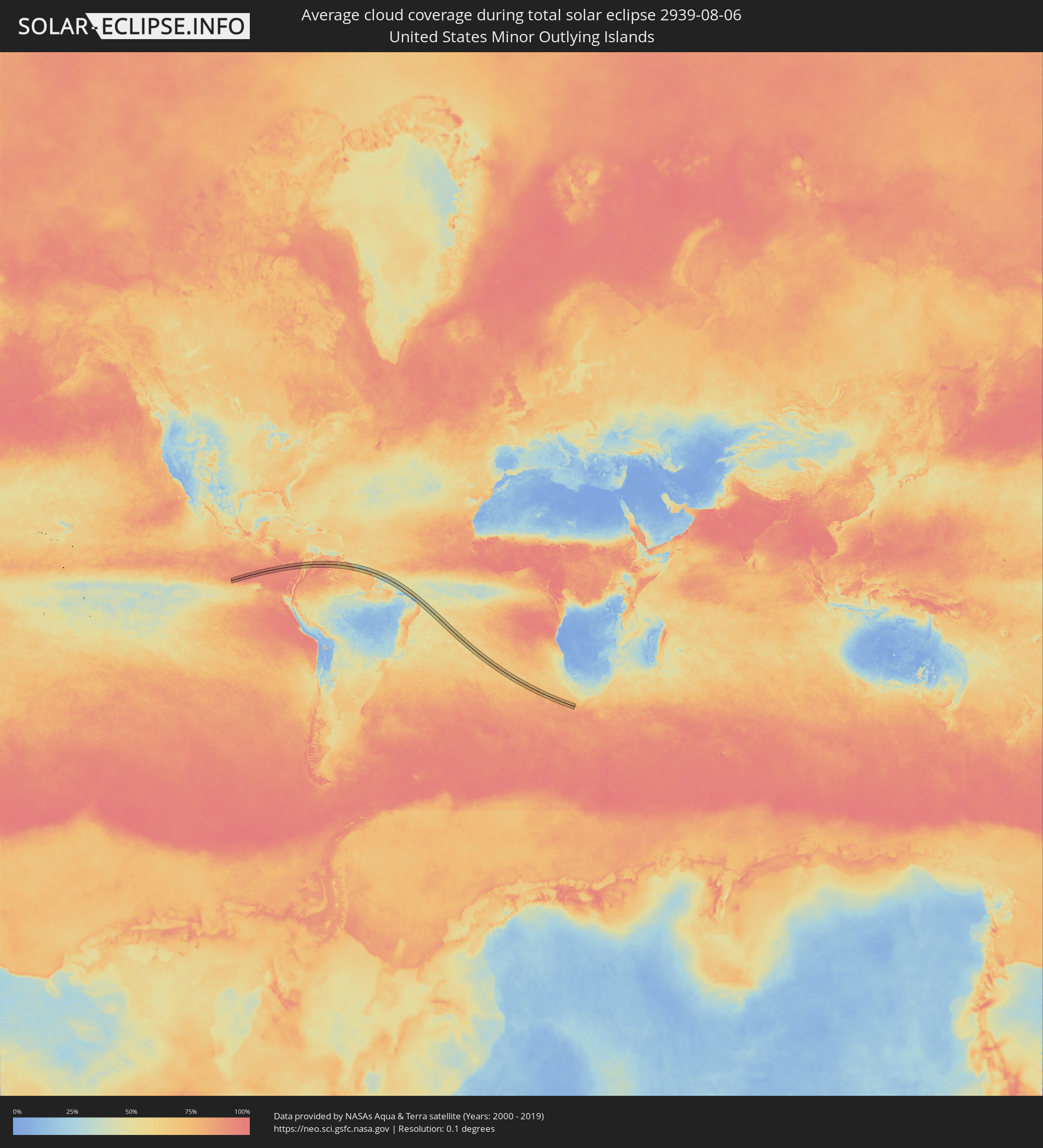
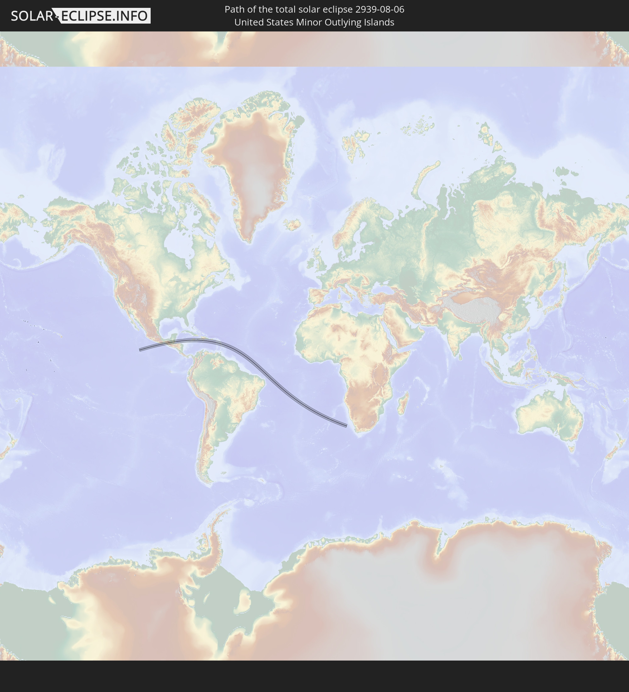 United States Minor Outlying Islands
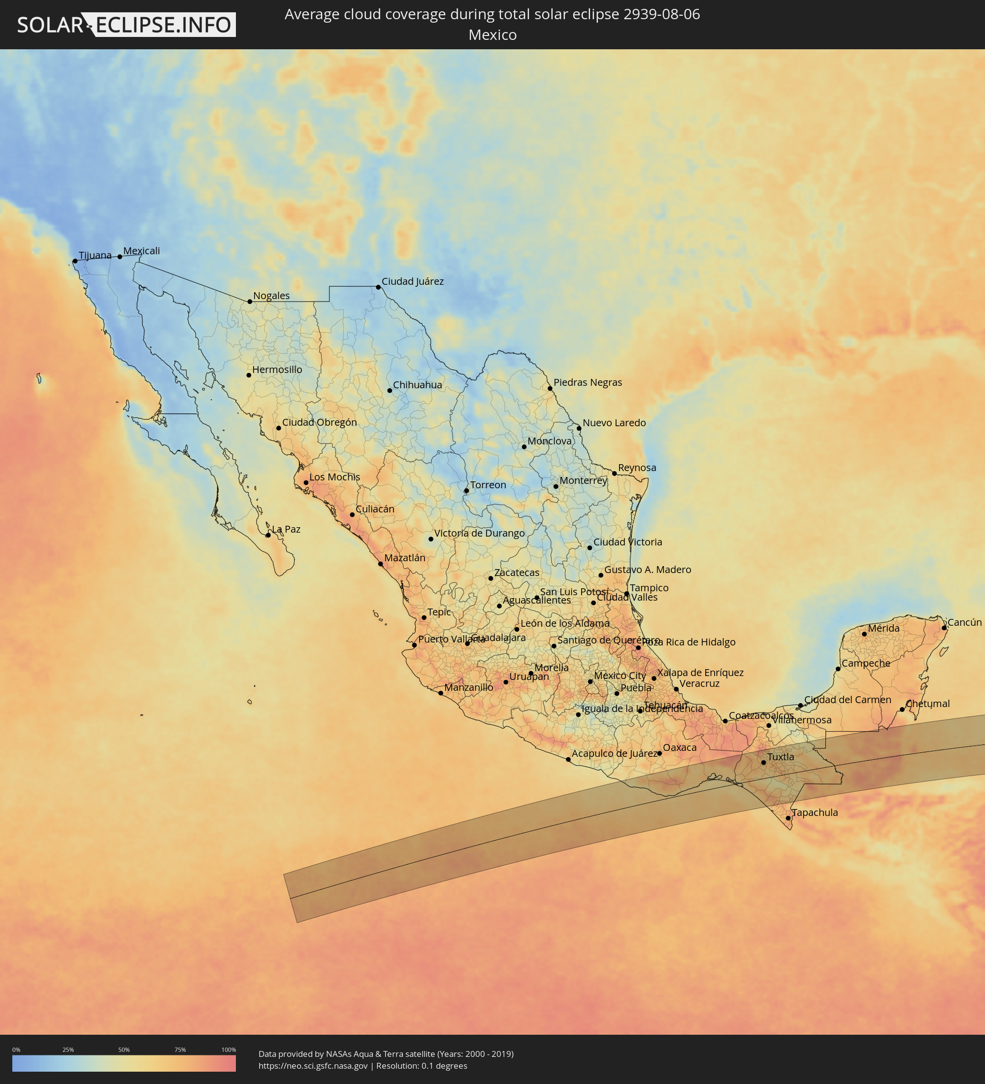
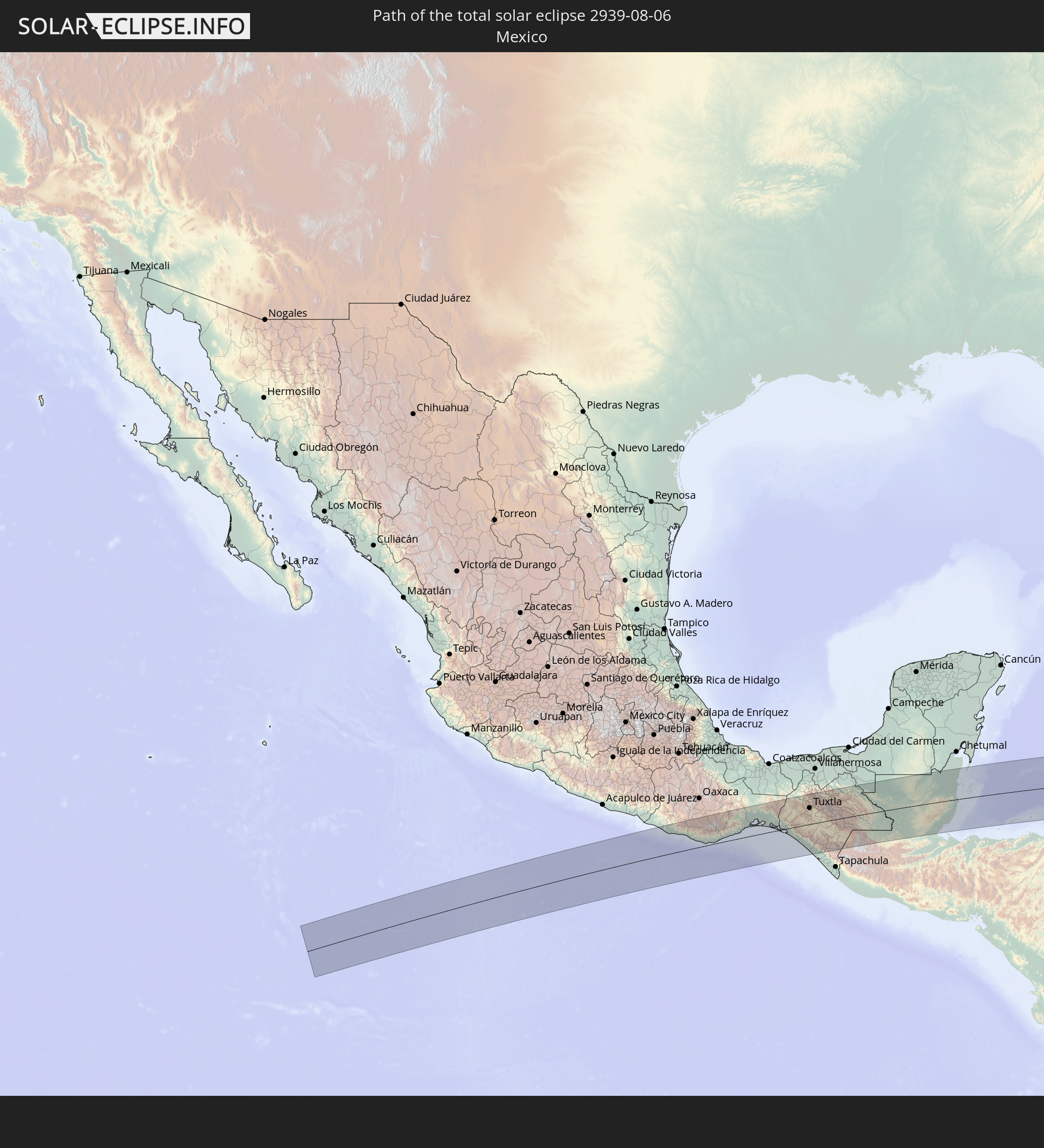 Mexico
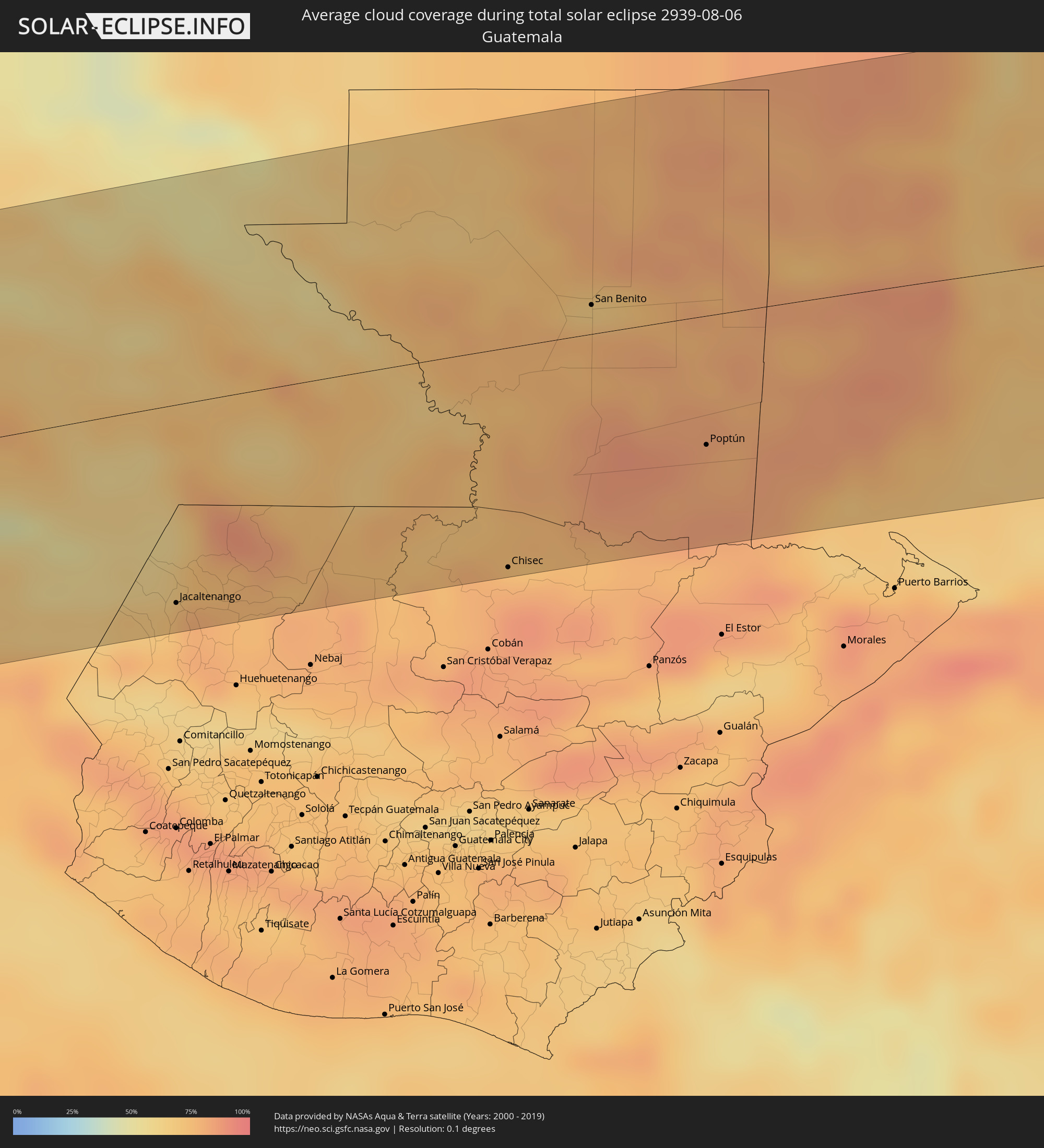
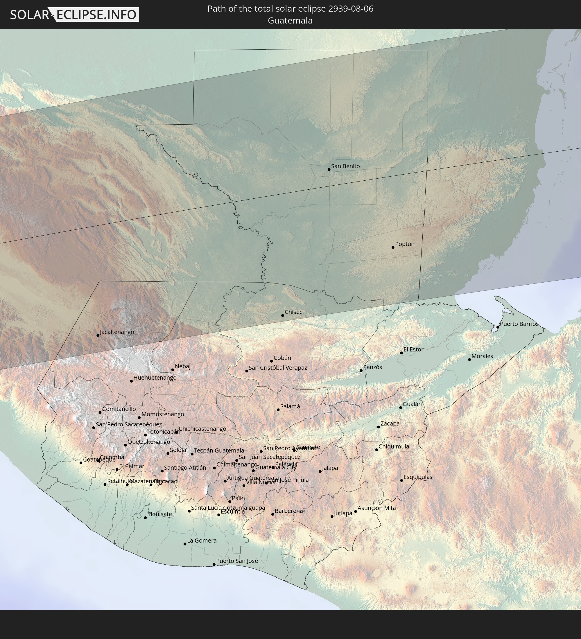 Guatemala
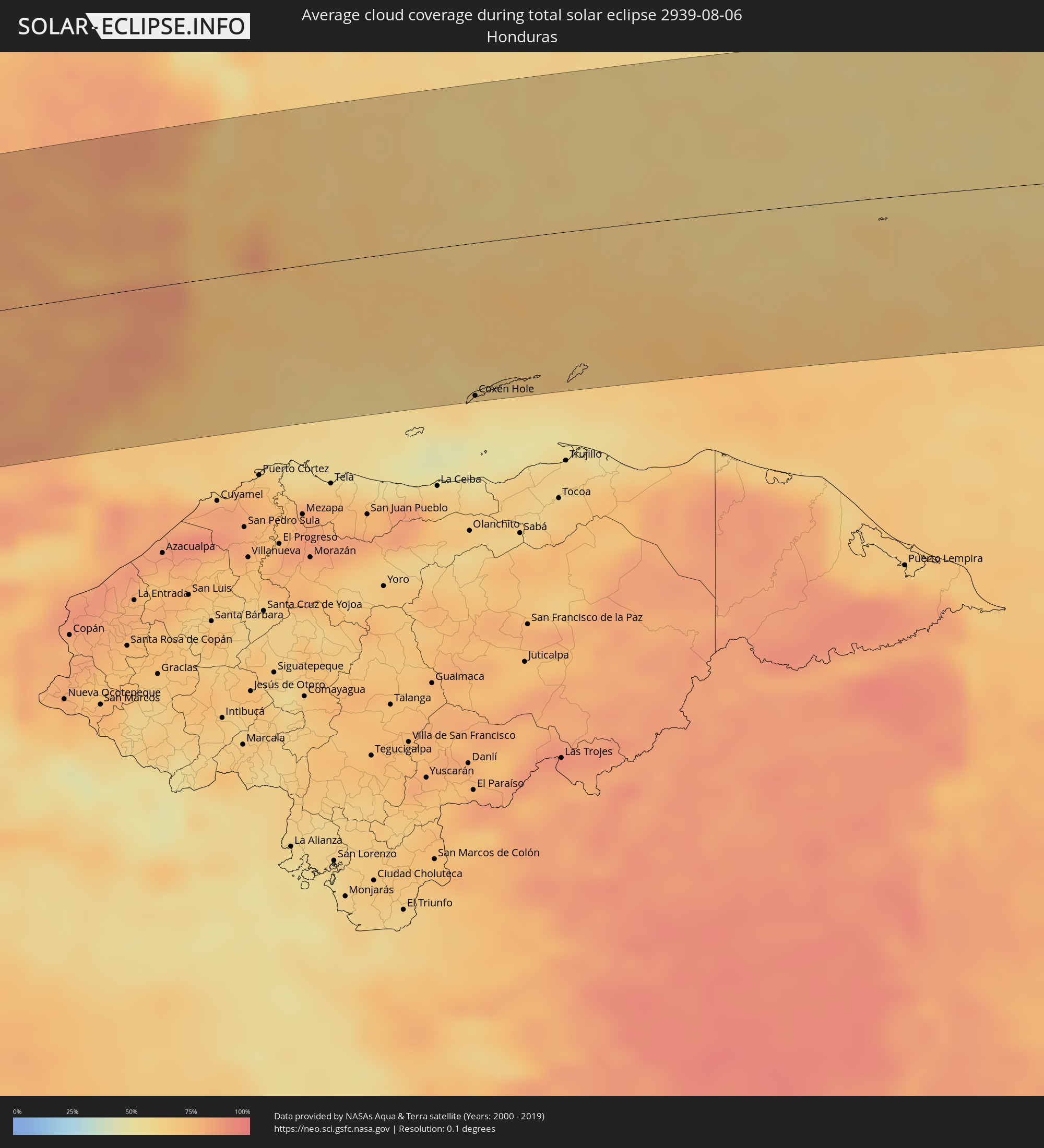
 Honduras
 Belize
 Jamaica
 Haiti
Haiti
 Brazil
 Dominican Republic
 Puerto Rico
 United States Virgin Islands
 Saint Kitts and Nevis
 Antigua and Barbuda
 Montserrat
 Guadeloupe
 Dominica
 Martinique
In den folgenden Ländern ist die Sonnenfinsternis partiell zu sehen
 United States
 United States Minor Outlying Islands
 Canada
 Mexico
 Chile
Chile
 Guatemala
 Ecuador
 El Salvador
 Honduras
 Belize
 Nicaragua
 Costa Rica
 Cuba
Cuba
 Panama
 Colombia
 Cayman Islands
 Peru
Peru
 The Bahamas
 Jamaica
 Haiti
Haiti
 Brazil
 Argentina
 Venezuela
 Turks and Caicos Islands
 Dominican Republic
 Aruba
Aruba
 Bolivia
 Puerto Rico
 United States Virgin Islands
 Bermuda
 British Virgin Islands
 Anguilla
 Collectivity of Saint Martin
 Saint Barthélemy
 Saint Kitts and Nevis
 Paraguay
 Antigua and Barbuda
 Montserrat
 Trinidad and Tobago
 Guadeloupe
 Grenada
 Dominica
 Saint Vincent and the Grenadines
 Guyana
 Martinique
 Saint Lucia
 Barbados
 Suriname
 French Guiana
 Cabo Verde
 Senegal
 Mauritania
 The Gambia
 Guinea-Bissau
 Guinea
 Saint Helena, Ascension and Tristan da Cunha
 Sierra Leone
 Mali
Mali
 Liberia
 Ivory Coast
 Burkina Faso
 Ghana
Ghana
 Togo
Togo
 Benin
Benin
 Nigeria
 Equatorial Guinea
 São Tomé and Príncipe
 Cameroon
 Gabon
Gabon
 Republic of the Congo
 Angola
 Namibia
 Democratic Republic of the Congo
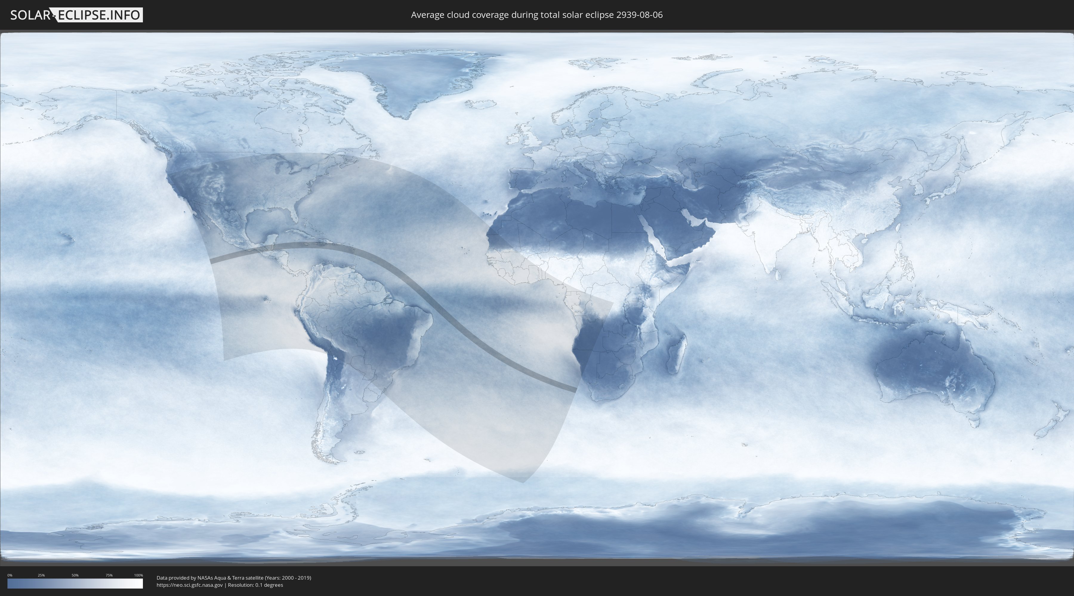
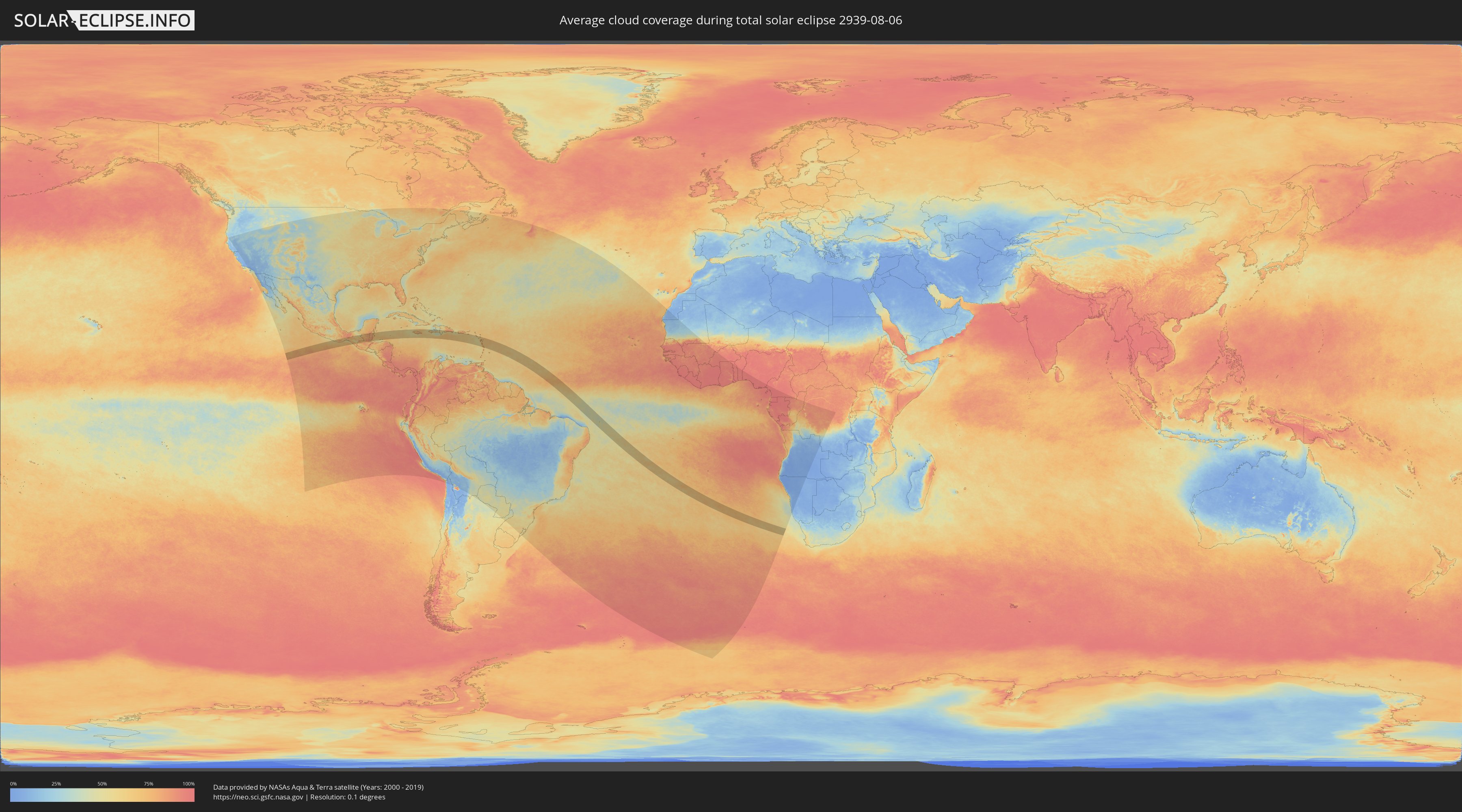
How will be the weather during the total solar eclipse on 08/06/2939?
Where is the best place to see the total solar eclipse of 08/06/2939?
The following maps show the average cloud coverage for the day of the total solar eclipse.
With the help of these maps, it is possible to find the place along the eclipse path, which has the best
chance of a cloudless sky.
Nevertheless, you should consider local circumstances and inform about the weather of your chosen
observation site.
The data is provided by NASAs satellites
AQUA and TERRA.
The cloud maps are averaged over a period of 19 years (2000 - 2019).
Detailed country maps
 United States Minor Outlying Islands
 Mexico
 Guatemala
 Honduras
 Belize
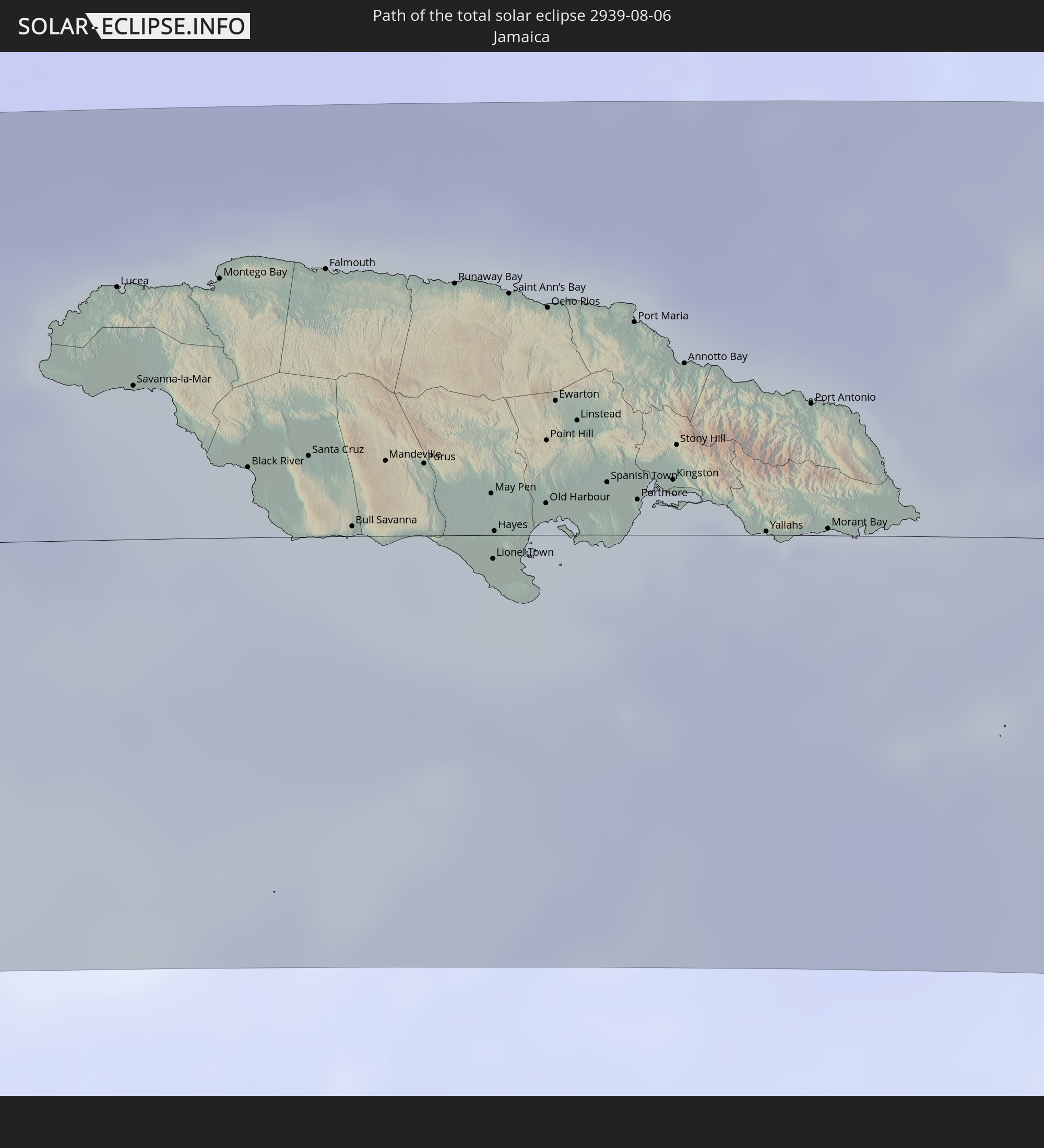
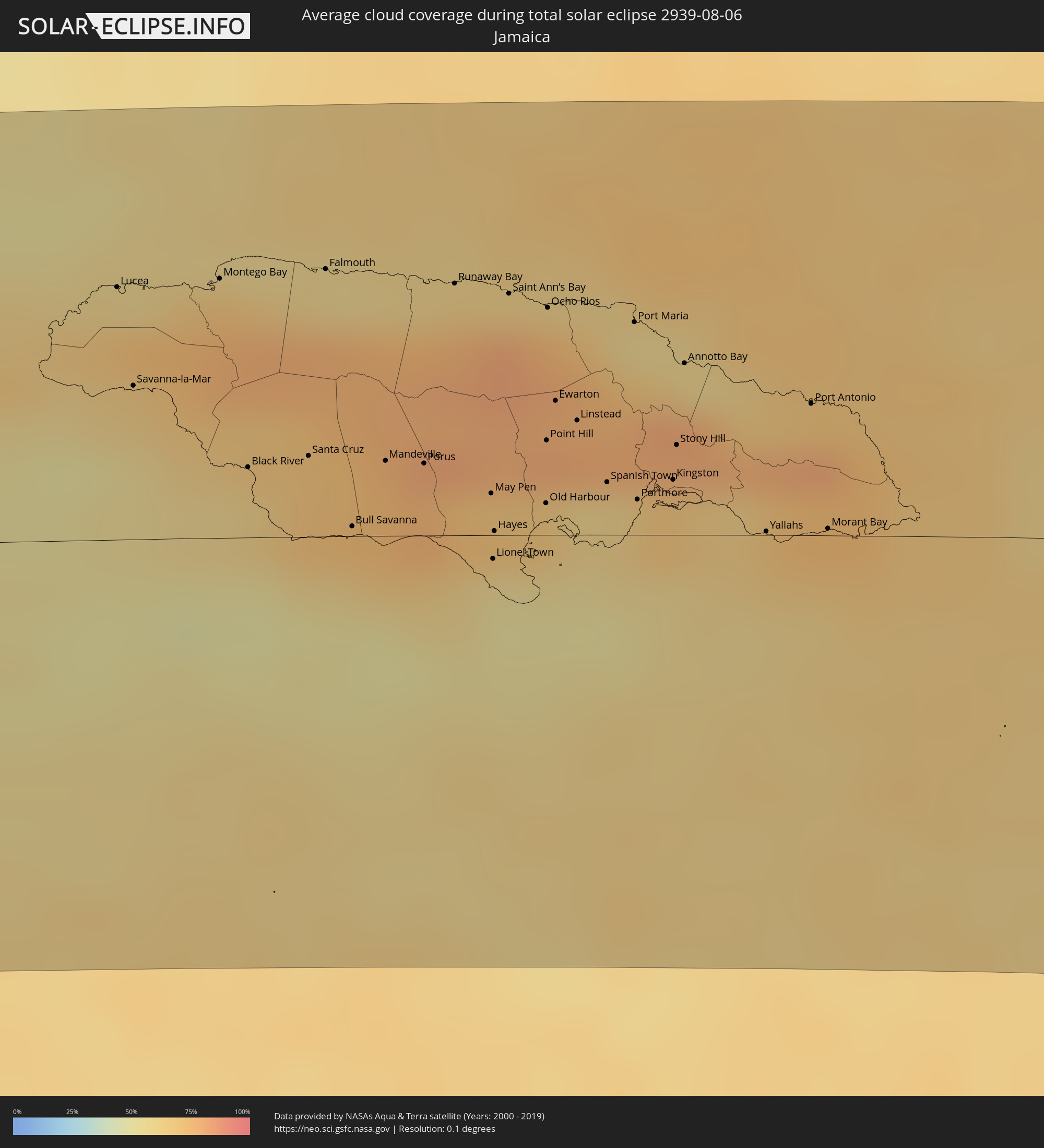 Jamaica
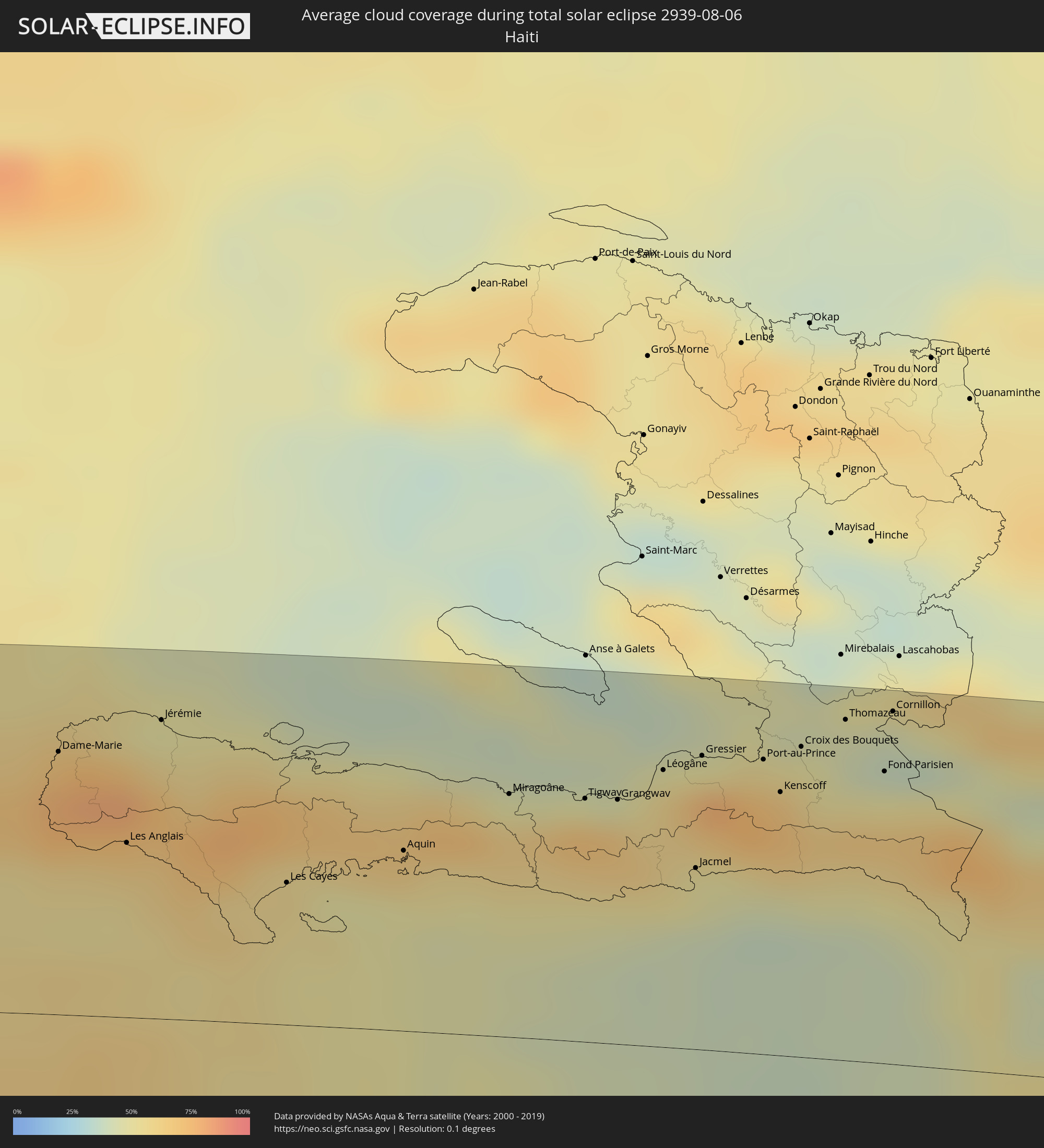 Haiti
Haiti
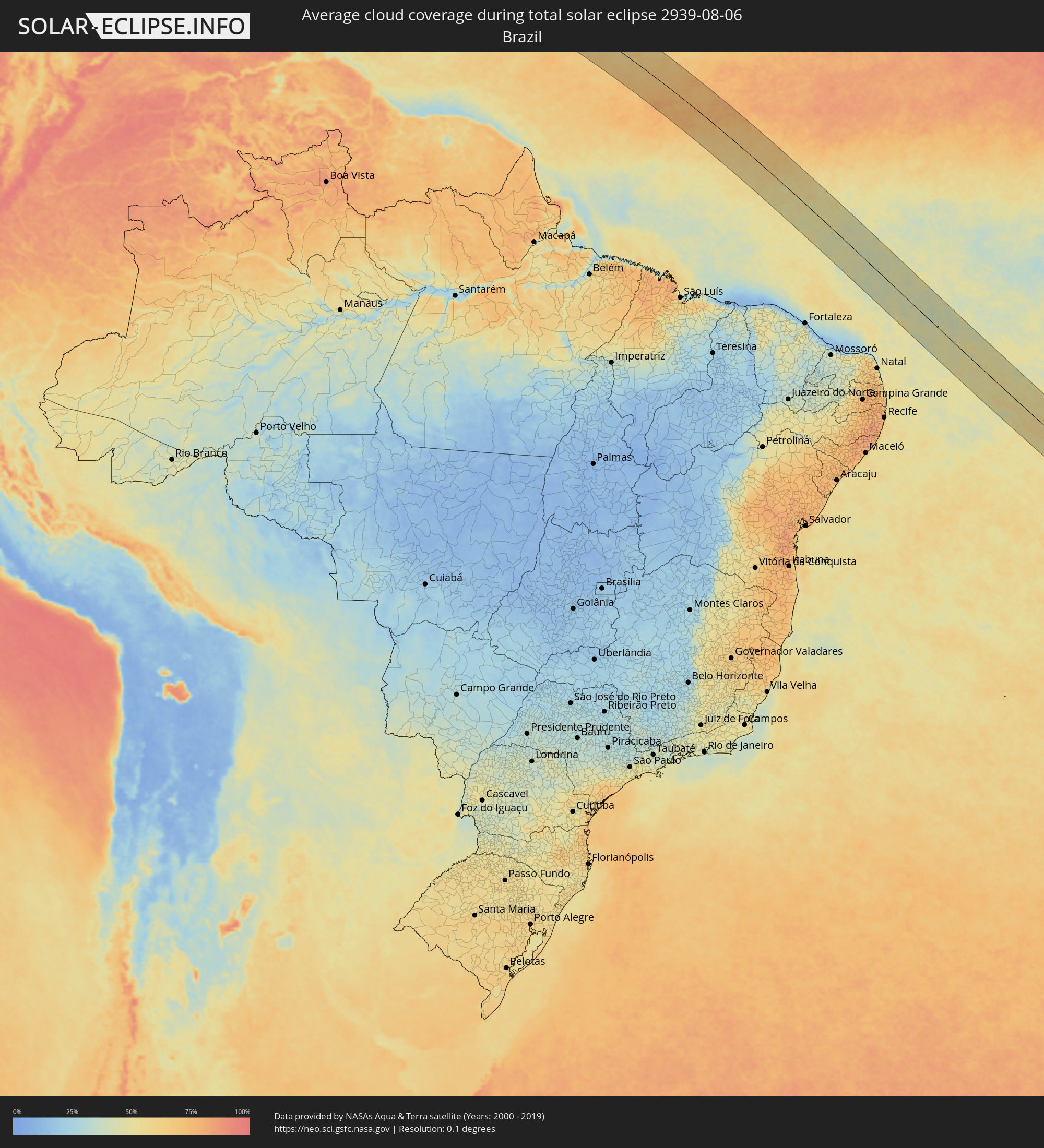 Brazil
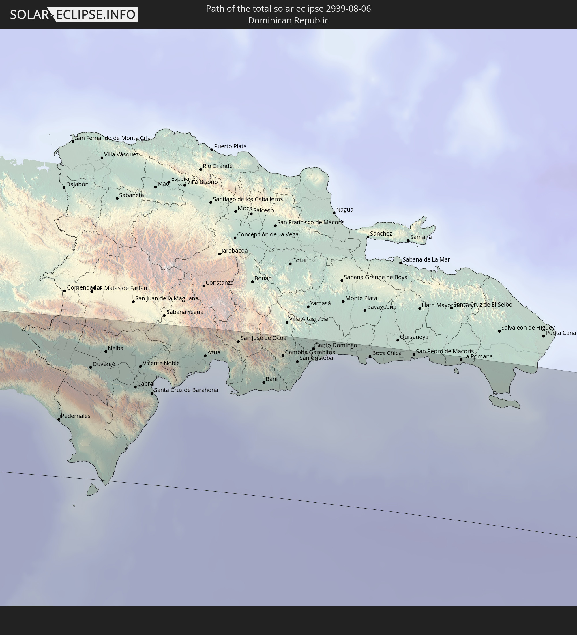
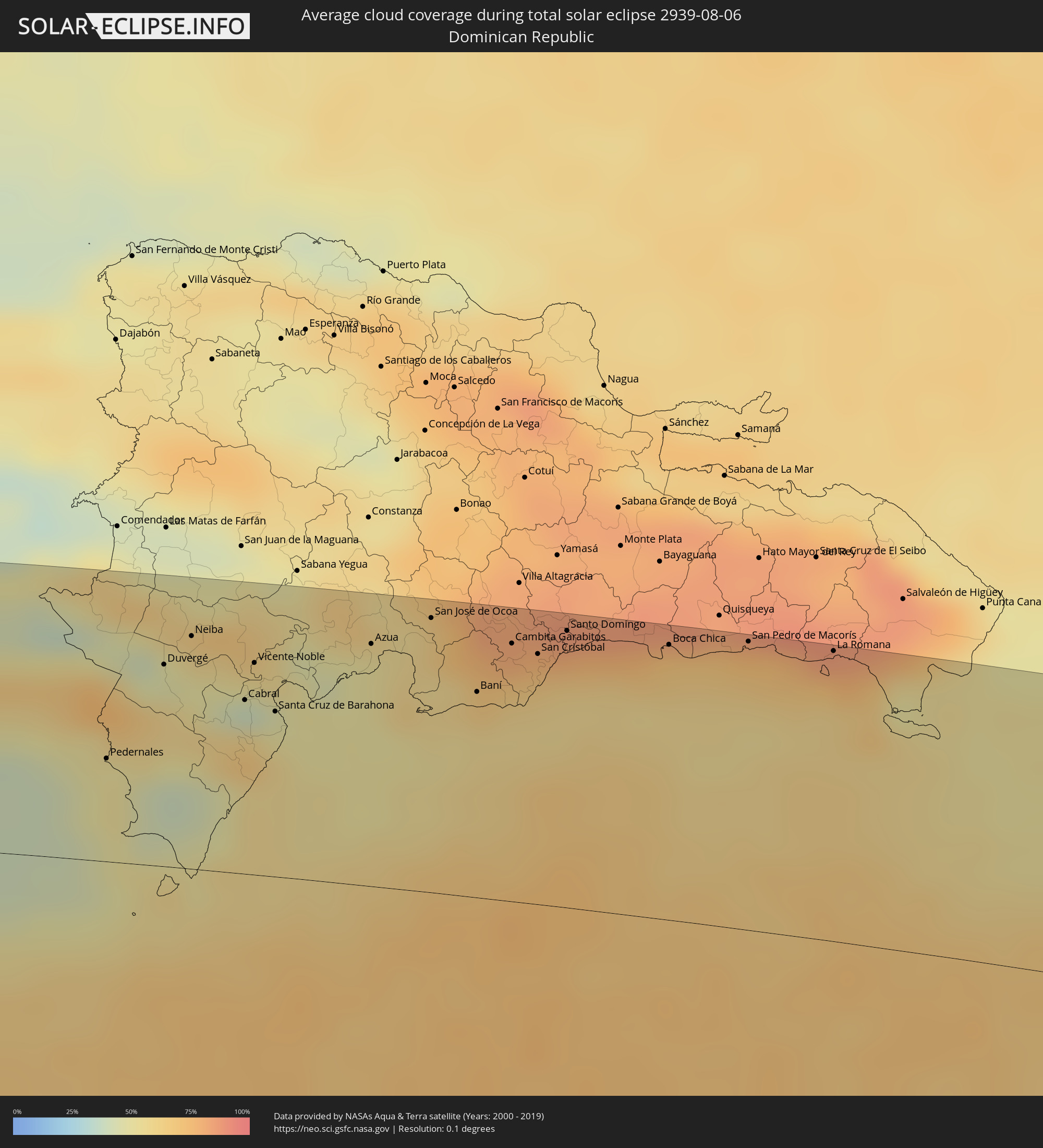 Dominican Republic
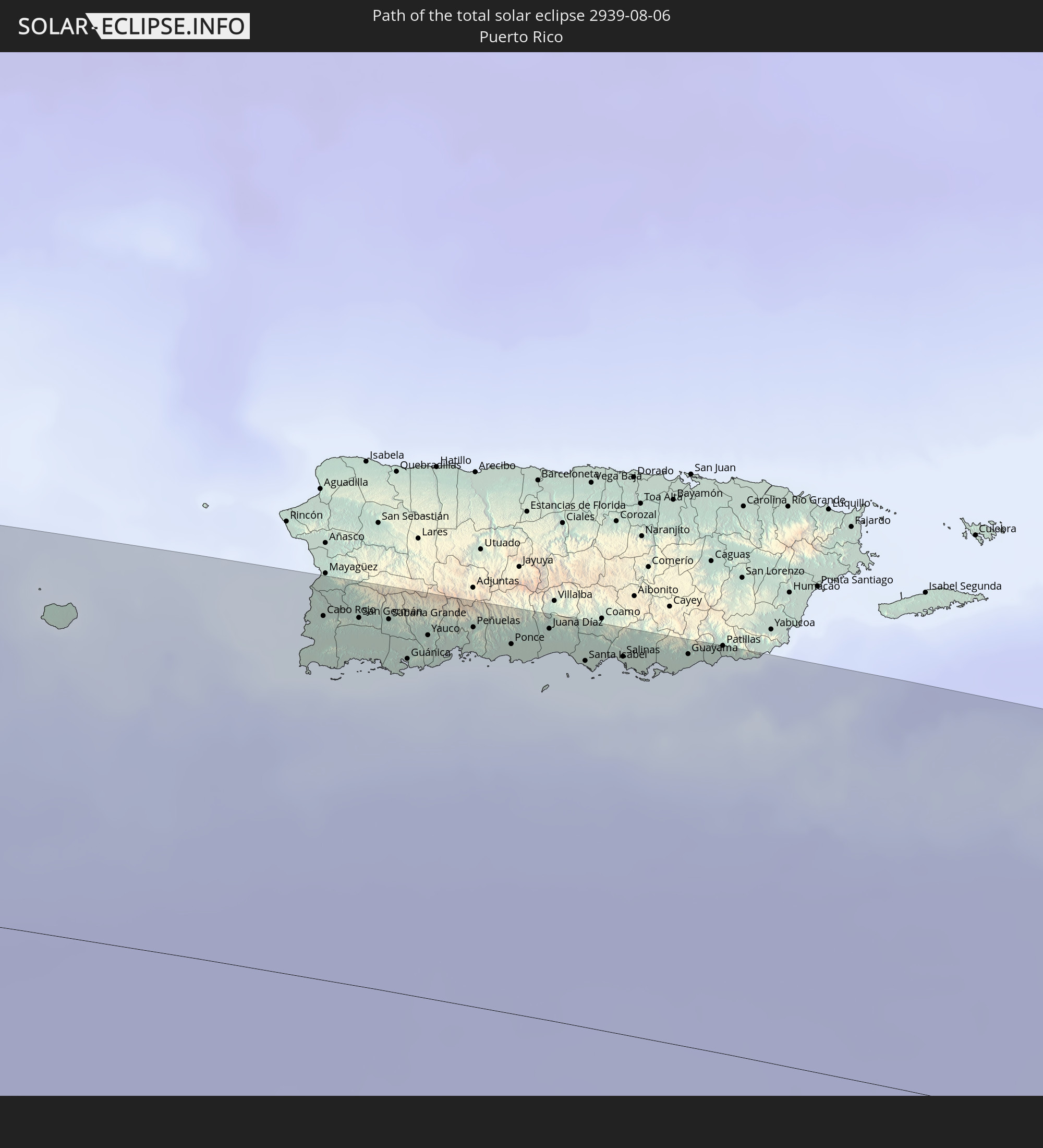
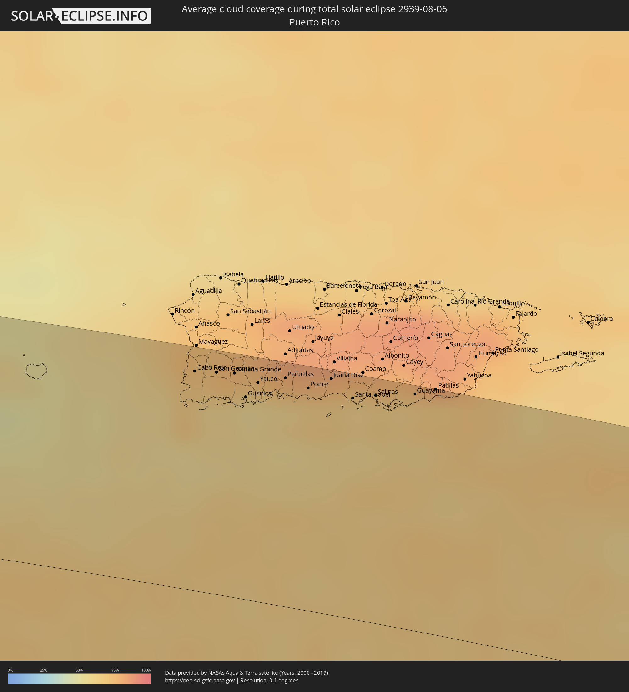 Puerto Rico
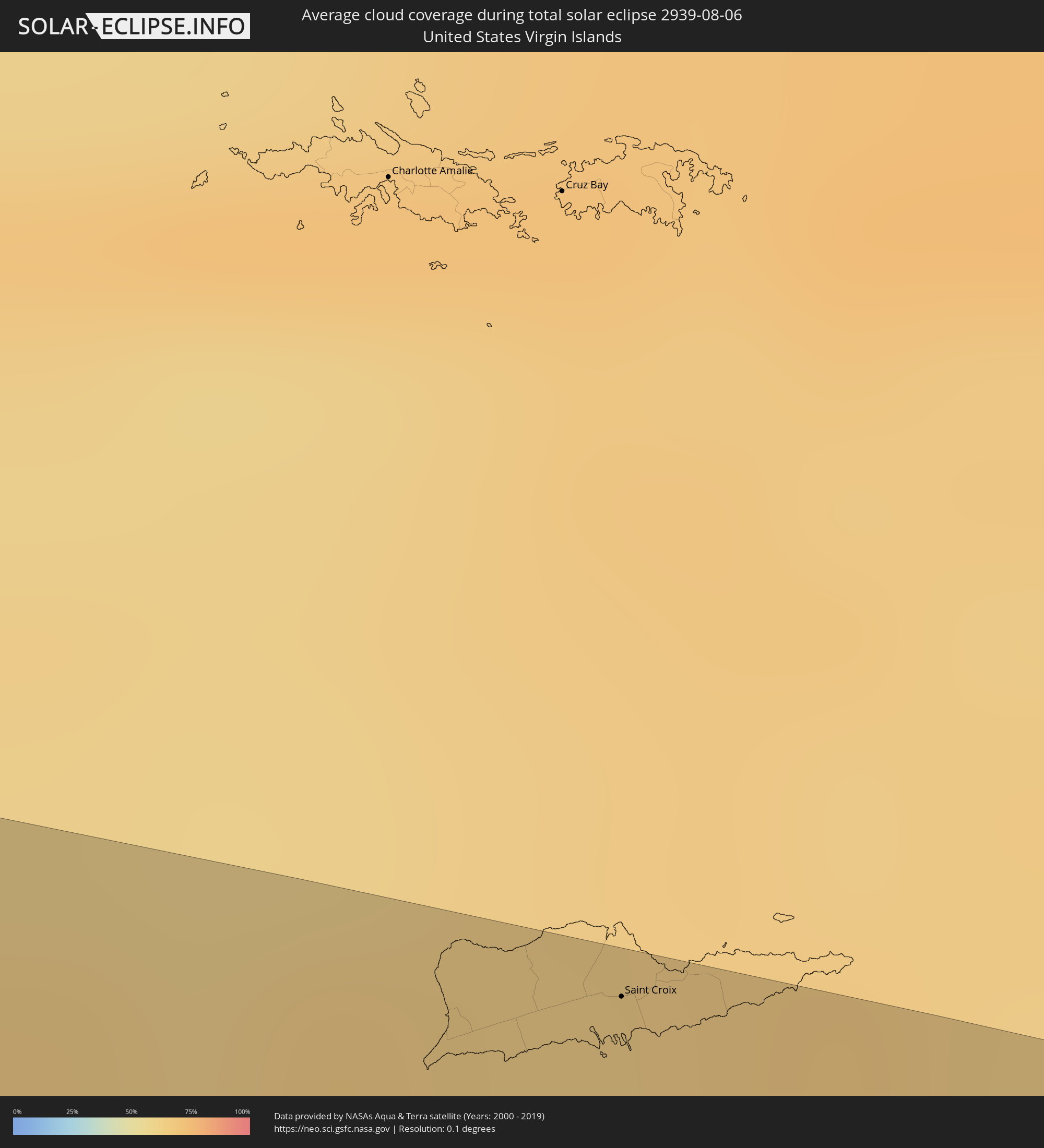 United States Virgin Islands
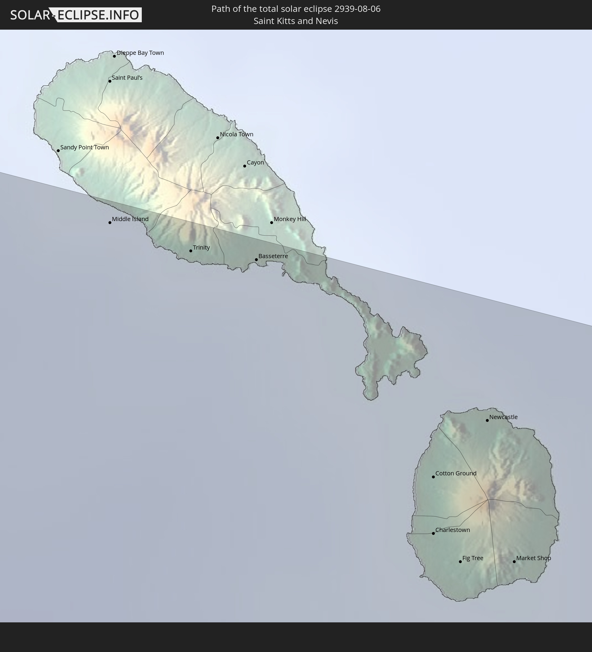
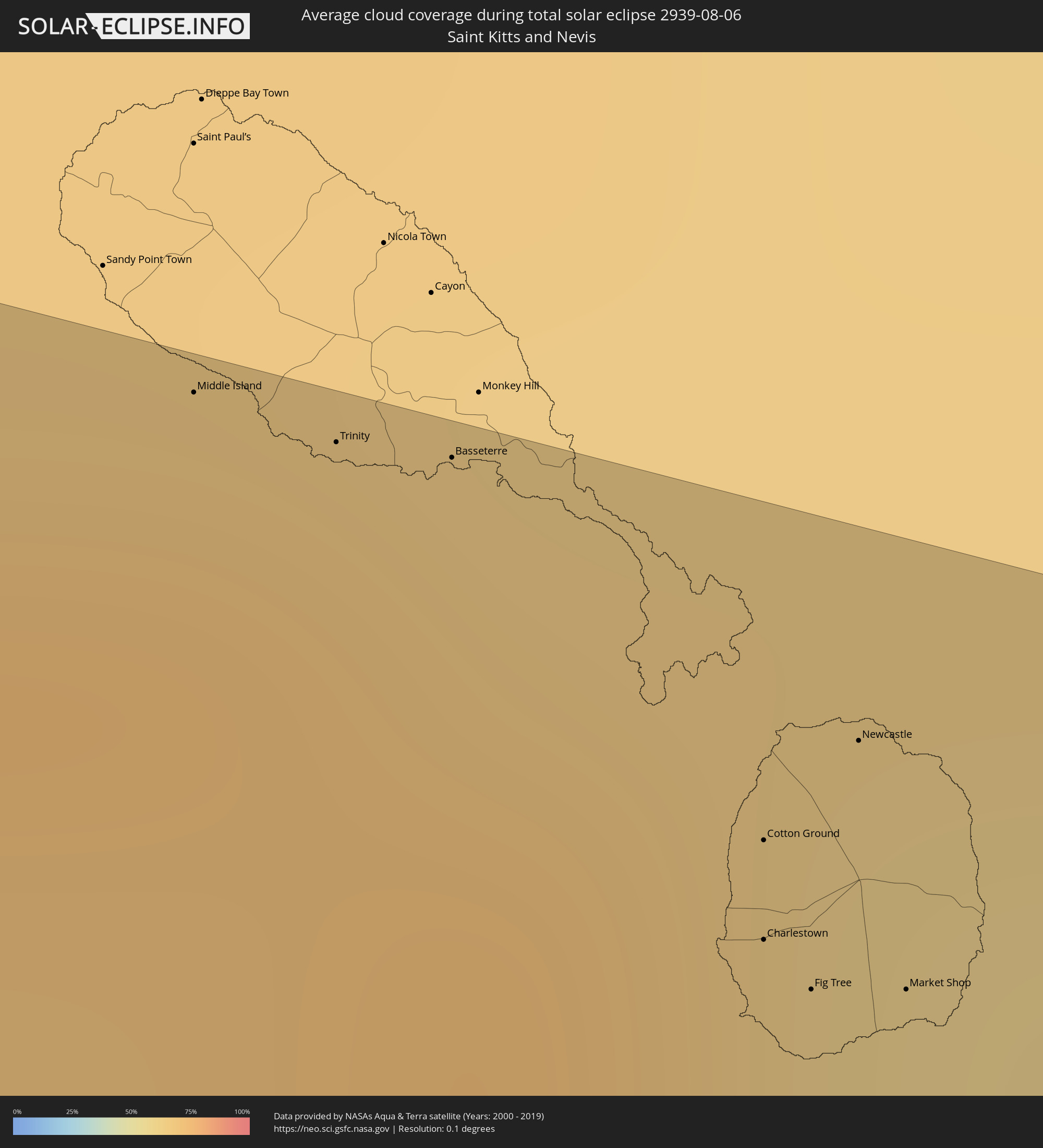 Saint Kitts and Nevis
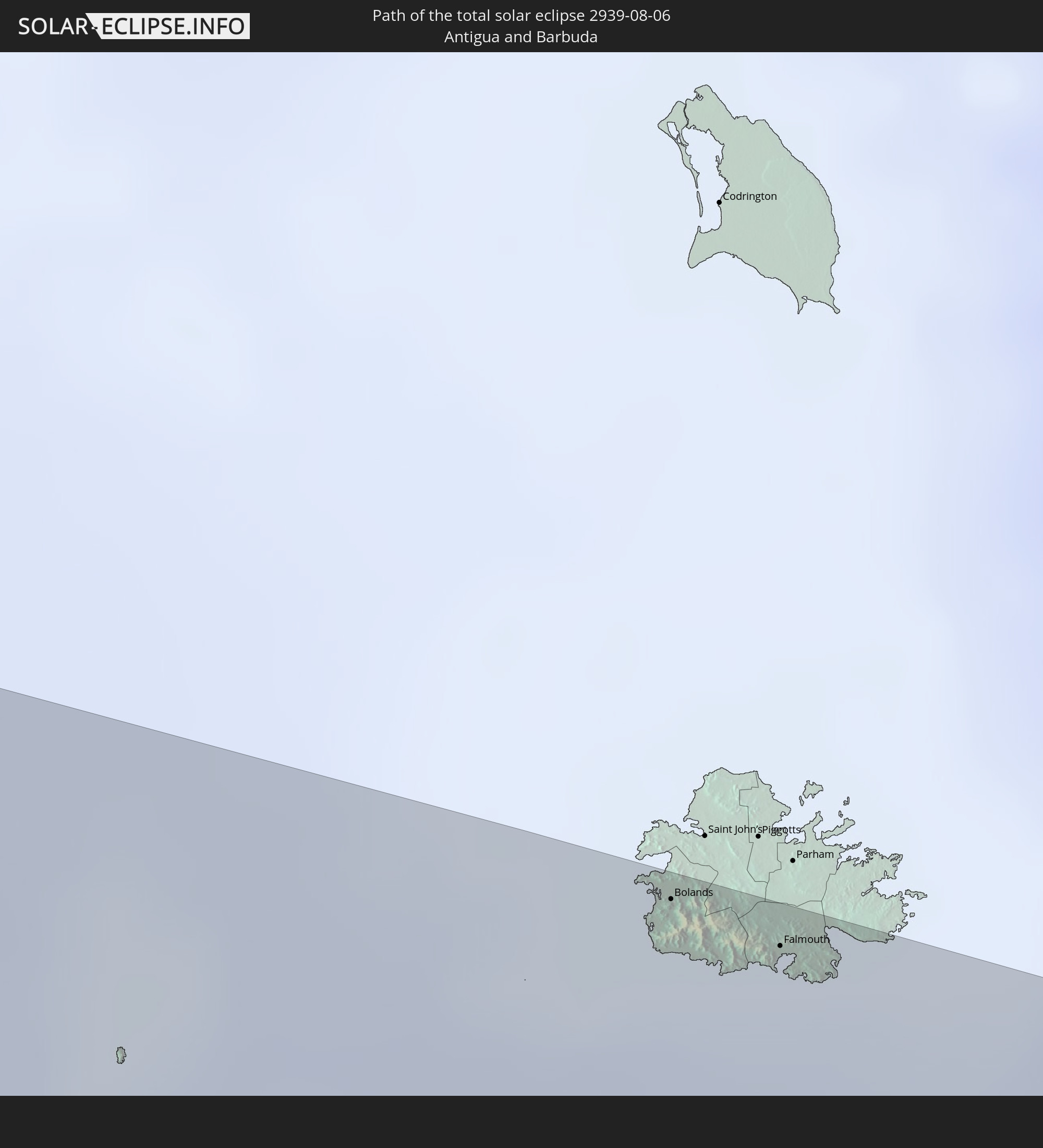
 Antigua and Barbuda
 Montserrat
 Guadeloupe
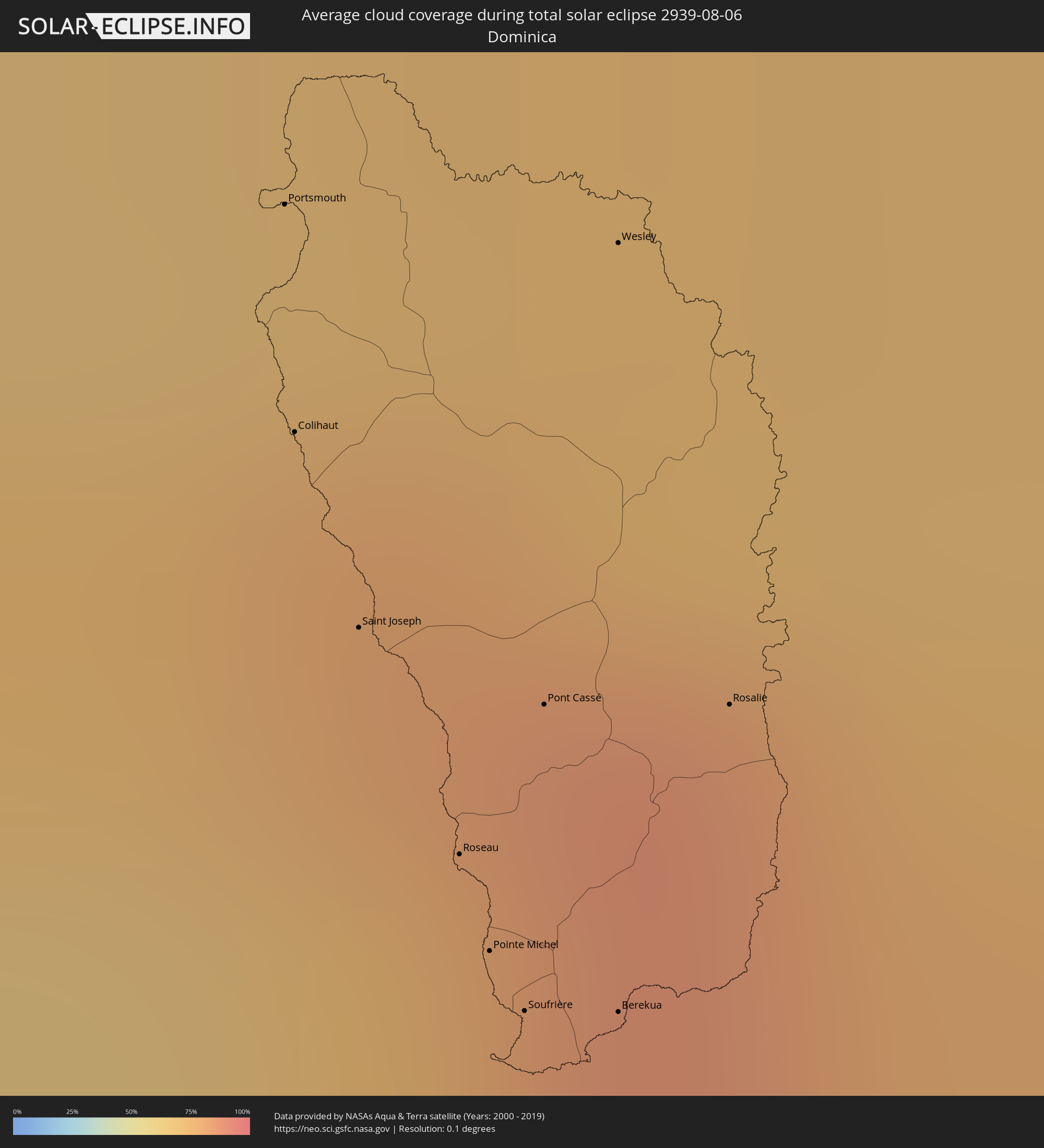 Dominica
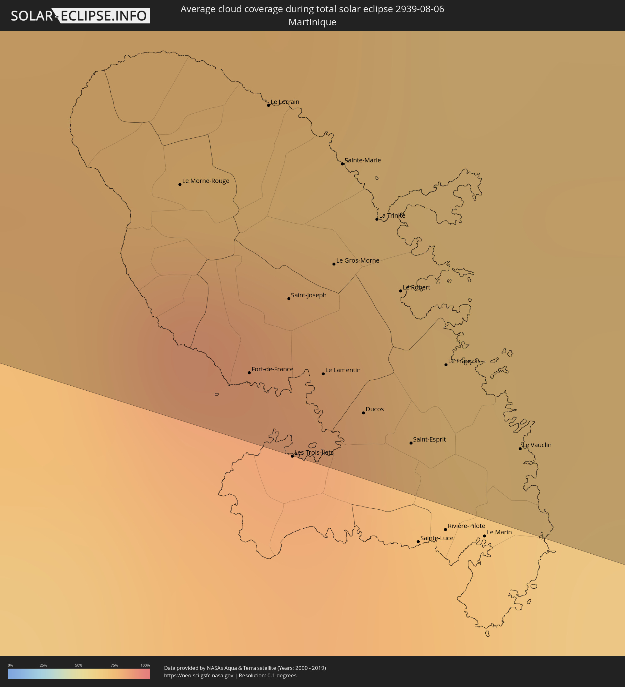 Martinique
Cities inside the path of the eclipse
The following table shows all locations with a population of more than 5,000 inside the eclipse path. Cities which have more than 100,000 inhabitants are marked bold. A click at the locations opens a detailed map.
| City | Type | Eclipse duration | Local time of max. eclipse | Distance to central line | Ø Cloud coverage |
|
Santo Domingo Tehuantepec, Oaxaca
|
total | - | 07:15:13 UTC-06:00 | 52 km | 71% |
|
Salina Cruz, Oaxaca
|
total | - | 07:15:14 UTC-06:00 | 36 km | 65% |
|
San Jerónimo Ixtepec, Oaxaca
|
total | - | 07:15:17 UTC-06:00 | 77 km | 70% |
|
Juchitán de Zaragoza, Oaxaca
|
total | - | 07:15:20 UTC-06:00 | 60 km | 58% |
|
Arriaga, Chiapas
|
total | - | 07:15:58 UTC-06:00 | 14 km | 60% |
|
Tonalá, Chiapas
|
total | - | 07:16:04 UTC-06:00 | 5 km | 62% |
|
Cintalapa de Figueroa, Chiapas
|
total | - | 07:16:04 UTC-06:00 | 59 km | 74% |
|
Ocozocoautla de Espinosa, Chiapas
|
total | - | 07:16:16 UTC-06:00 | 61 km | 73% |
|
Tuxtla, Chiapas
|
total | - | 07:16:26 UTC-06:00 | 55 km | 74% |
|
San Cristóbal de las Casas, Chiapas
|
total | - | 07:16:44 UTC-06:00 | 43 km | 75% |
|
Comitán, Chiapas
|
total | - | 07:17:06 UTC-06:00 | 20 km | 61% |
|
Ocosingo, Chiapas
|
total | - | 07:17:05 UTC-06:00 | 51 km | 61% |
|
Las Margaritas, Chiapas
|
total | - | 07:17:12 UTC-06:00 | 16 km | 58% |
|
Jacaltenango, Huehuetenango
|
total | - | 07:17:25 UTC-06:00 | 91 km | 79% |
|
Concepción, Huehuetenango
|
total | - | 07:17:28 UTC-06:00 | 98 km | 80% |
|
San Mateo Ixtatán, Huehuetenango
|
total | - | 07:17:35 UTC-06:00 | 78 km | 76% |
|
Soloma, Huehuetenango
|
total | - | 07:17:37 UTC-06:00 | 91 km | 75% |
|
Tenosique de Pino Suárez, Tabasco
|
total | - | 07:17:31 UTC-06:00 | 101 km | 59% |
|
Barillas, Huehuetenango
|
total | - | 07:17:42 UTC-06:00 | 84 km | 74% |
|
San Luis Ixcán, Quiché
|
total | - | 07:17:52 UTC-06:00 | 90 km | 79% |
|
Chisec, Alta Verapaz
|
total | - | 07:18:28 UTC-06:00 | 101 km | 80% |
|
Sayaxché, Petén
|
total | - | 07:18:29 UTC-06:00 | 26 km | 75% |
|
La Libertad, Petén
|
total | - | 07:18:30 UTC-06:00 | 2 km | 75% |
|
San Benito, Petén
|
total | - | 07:18:39 UTC-06:00 | 13 km | 78% |
|
Santa Ana, Petén
|
total | - | 07:18:43 UTC-06:00 | 1 km | 79% |
|
Poptún, Petén
|
total | - | 07:19:06 UTC-06:00 | 59 km | 80% |
|
Dolores, Petén
|
total | - | 07:19:05 UTC-06:00 | 39 km | 83% |
|
Melchor de Mencos, Petén
|
total | - | 07:19:14 UTC-06:00 | 17 km | 81% |
|
Benque Viejo del Carmen, Cayo
|
total | - | 07:19:15 UTC-06:00 | 18 km | 81% |
|
San Ignacio, Cayo
|
total | - | 07:19:17 UTC-06:00 | 26 km | 74% |
|
Punta Gorda, Toledo
|
total | - | 07:19:37 UTC-06:00 | 95 km | 70% |
|
Belmopan, Cayo
|
total | - | 07:19:32 UTC-06:00 | 31 km | 79% |
|
Dangriga, Stann Creek
|
total | - | 07:20:00 UTC-06:00 | 8 km | 70% |
|
Belize City, Belize
|
total | - | 07:19:59 UTC-06:00 | 50 km | 71% |
|
San Pedro, Belize
|
total | - | 07:20:09 UTC-06:00 | 92 km | 68% |
|
Coxen Hole, Bay Islands
|
total | - | 07:21:37 UTC-06:00 | 104 km | 57% |
|
Savanna-la-Mar, Westmoreland
|
total | - | 08:30:50 UTC-05:00 | 40 km | 62% |
|
Montego Bay, St. James
|
total | - | 08:31:03 UTC-05:00 | 68 km | 69% |
|
Santa Cruz, St. Elizabeth
|
total | - | 08:31:28 UTC-05:00 | 21 km | 70% |
|
Falmouth, Trelawny
|
total | - | 08:31:24 UTC-05:00 | 70 km | 63% |
|
Mandeville, Manchester
|
total | - | 08:31:44 UTC-05:00 | 20 km | 74% |
|
May Pen, Clarendon
|
total | - | 08:32:07 UTC-05:00 | 11 km | 69% |
|
Saint Ann’s Bay, St Ann
|
total | - | 08:32:02 UTC-05:00 | 63 km | 81% |
|
Old Harbour Bay, Saint Catherine
|
total | - | 08:32:20 UTC-05:00 | 5 km | 56% |
|
Linstead, Saint Catherine
|
total | - | 08:32:22 UTC-05:00 | 30 km | 79% |
|
Spanish Town, Saint Catherine
|
total | - | 08:32:31 UTC-05:00 | 14 km | 61% |
|
Port Maria, St. Mary
|
total | - | 08:32:29 UTC-05:00 | 56 km | 60% |
|
Kingston, Kingston
|
total | - | 08:32:44 UTC-05:00 | 15 km | 69% |
|
Port Antonio, Portland
|
total | - | 08:33:10 UTC-05:00 | 35 km | 68% |
|
Morant Bay, St. Thomas
|
total | - | 08:33:19 UTC-05:00 | 2 km | 66% |
|
Les Anglais, Sud
|
total | - | 08:36:26 UTC-05:00 | 55 km | 62% |
|
Jérémie, GrandʼAnse
|
total | - | 08:36:27 UTC-05:00 | 93 km | 49% |
|
Les Cayes, Sud
|
total | - | 08:37:12 UTC-05:00 | 45 km | 55% |
|
Miragoâne, Nippes
|
total | - | 08:38:09 UTC-05:00 | 76 km | 62% |
|
Tigwav, Ouest
|
total | - | 08:38:30 UTC-05:00 | 76 km | 69% |
|
Grangwav, Ouest
|
total | - | 08:38:40 UTC-05:00 | 76 km | 67% |
|
Léogâne, Ouest
|
total | - | 08:38:51 UTC-05:00 | 87 km | 64% |
|
Jacmel, Sud-Est
|
total | - | 08:39:07 UTC-05:00 | 57 km | 47% |
|
Gressier, Ouest
|
total | - | 08:39:01 UTC-05:00 | 92 km | 52% |
|
Port-au-Prince, Ouest
|
total | - | 08:39:19 UTC-05:00 | 92 km | 66% |
|
Kenscoff, Ouest
|
total | - | 08:39:26 UTC-05:00 | 82 km | 70% |
|
Thomazeau, Ouest
|
total | - | 08:39:39 UTC-05:00 | 106 km | 44% |
|
Fond Parisien, Ouest
|
total | - | 08:39:55 UTC-05:00 | 91 km | 51% |
|
Cornillon, Ouest
|
total | - | 08:39:52 UTC-05:00 | 110 km | 42% |
|
Pedernales, Pedernales
|
total | - | 09:40:31 UTC-04:00 | 41 km | 52% |
|
Duvergé, Independencia
|
total | - | 09:40:43 UTC-04:00 | 81 km | 47% |
|
Neiba, Baoruco
|
total | - | 09:40:51 UTC-04:00 | 93 km | 57% |
|
Vicente Noble, Barahona
|
total | - | 09:41:17 UTC-04:00 | 85 km | 51% |
|
Santa Cruz de Barahona, Barahona
|
total | - | 09:41:31 UTC-04:00 | 66 km | 52% |
|
Azua, Azua
|
total | - | 09:42:01 UTC-04:00 | 97 km | 53% |
|
San José de Ocoa, San José de Ocoa
|
total | - | 09:42:21 UTC-04:00 | 110 km | 63% |
|
Baní, Peravia
|
total | - | 09:42:47 UTC-04:00 | 82 km | 65% |
|
Paya, Peravia
|
total | - | 09:42:52 UTC-04:00 | 81 km | 65% |
|
Cambita Garabitos, San Cristóbal
|
total | - | 09:42:56 UTC-04:00 | 103 km | 80% |
|
Santo Domingo, Nacional
|
total | - | 09:43:16 UTC-04:00 | 111 km | 78% |
|
Boca Chica, Santo Domingo
|
total | - | 09:43:58 UTC-04:00 | 110 km | 71% |
|
San Pedro de Macorís, San Pedro de Macorís
|
total | - | 09:44:30 UTC-04:00 | 115 km | 74% |
|
La Romana, La Romana
|
total | - | 09:45:06 UTC-04:00 | 116 km | 71% |
|
Puerto Real, Cabo Rojo
|
total | - | 09:48:35 UTC-04:00 | 106 km | 68% |
|
Cabo Rojo, Cabo Rojo
|
total | - | 09:48:39 UTC-04:00 | 108 km | 69% |
|
San Germán, San German
|
total | - | 09:48:50 UTC-04:00 | 109 km | 72% |
|
Sabana Grande, Sabana Grande
|
total | - | 09:49:00 UTC-04:00 | 110 km | 72% |
|
Guánica, Guanica
|
total | - | 09:49:10 UTC-04:00 | 99 km | 57% |
|
Yauco, Yauco
|
total | - | 09:49:14 UTC-04:00 | 107 km | 59% |
|
Peñuelas, Penuelas
|
total | - | 09:49:28 UTC-04:00 | 112 km | 77% |
|
Ponce, Ponce
|
total | - | 09:49:42 UTC-04:00 | 109 km | 64% |
|
Juana Díaz, Juana Diaz
|
total | - | 09:49:53 UTC-04:00 | 116 km | 76% |
|
Santa Isabel, Santa Isabel Municipio
|
total | - | 09:50:08 UTC-04:00 | 108 km | 62% |
|
Salinas, Salinas
|
total | - | 09:50:20 UTC-04:00 | 111 km | 64% |
|
Coco, Salinas
|
total | - | 09:50:23 UTC-04:00 | 115 km | 64% |
|
Guayama, Guayama
|
total | - | 09:50:41 UTC-04:00 | 116 km | 66% |
|
Arroyo, Arroyo
|
total | - | 09:50:47 UTC-04:00 | 115 km | 66% |
|
Saint Croix, Saint Croix Island
|
total | - | 09:53:32 UTC-04:00 | 117 km | 65% |
|
Middle Island, Saint Thomas Middle Island
|
total | - | 09:57:47 UTC-04:00 | 120 km | 70% |
|
Trinity, Trinity Palmetto Point
|
total | - | 09:57:54 UTC-04:00 | 120 km | 70% |
|
Basseterre, Saint George Basseterre
|
total | - | 09:57:59 UTC-04:00 | 121 km | 71% |
|
Cotton Ground, Saint Thomas Lowland
|
total | - | 09:58:19 UTC-04:00 | 110 km | 66% |
|
Charlestown, Saint Paul Charlestown
|
total | - | 09:58:21 UTC-04:00 | 106 km | 60% |
|
Fig Tree, Saint John Figtree
|
total | - | 09:58:24 UTC-04:00 | 105 km | 60% |
|
Newcastle, Saint James Windwa
|
total | - | 09:58:22 UTC-04:00 | 114 km | 66% |
|
Market Shop, Saint George Gingerland
|
total | - | 09:58:28 UTC-04:00 | 106 km | 60% |
|
Saint Peters, Saint Peter
|
total | - | 09:59:31 UTC-04:00 | 79 km | 70% |
|
Plymouth, Saint Anthony
|
total | - | 09:59:35 UTC-04:00 | 72 km | 67% |
|
Brades, Saint Peter
|
total | - | 09:59:31 UTC-04:00 | 81 km | 70% |
|
Bolands, Saint Mary
|
total | - | 09:59:58 UTC-04:00 | 120 km | 76% |
|
Pointe-Noire, Guadeloupe
|
total | - | 10:00:56 UTC-04:00 | 33 km | 73% |
|
Falmouth, Saint Paul
|
total | - | 10:00:12 UTC-04:00 | 119 km | 66% |
|
Bouillante, Guadeloupe
|
total | - | 10:01:04 UTC-04:00 | 23 km | 68% |
|
Vieux-Habitants, Guadeloupe
|
total | - | 10:01:09 UTC-04:00 | 16 km | 68% |
|
Basse-Terre, Guadeloupe
|
total | - | 10:01:18 UTC-04:00 | 10 km | 71% |
|
Saint-Claude, Guadeloupe
|
total | - | 10:01:19 UTC-04:00 | 14 km | 71% |
|
Sainte-Rose, Guadeloupe
|
total | - | 10:01:02 UTC-04:00 | 47 km | 81% |
|
Gourbeyre, Guadeloupe
|
total | - | 10:01:22 UTC-04:00 | 11 km | 71% |
|
Trois-Rivières, Guadeloupe
|
total | - | 10:01:29 UTC-04:00 | 10 km | 70% |
|
Capesterre-Belle-Eau, Guadeloupe
|
total | - | 10:01:36 UTC-04:00 | 20 km | 70% |
|
Les Abymes, Guadeloupe
|
total | - | 10:01:30 UTC-04:00 | 46 km | 76% |
|
Petit-Canal, Guadeloupe
|
total | - | 10:01:26 UTC-04:00 | 58 km | 72% |
|
Portsmouth, Saint John
|
total | - | 10:02:16 UTC-04:00 | 26 km | 73% |
|
Colihaut, Saint Peter
|
total | - | 10:02:22 UTC-04:00 | 36 km | 71% |
|
Saint Joseph, Saint Joseph
|
total | - | 10:02:31 UTC-04:00 | 45 km | 74% |
|
Roseau, Saint George
|
total | - | 10:02:43 UTC-04:00 | 54 km | 73% |
|
Pointe Michel, Saint Luke
|
total | - | 10:02:47 UTC-04:00 | 58 km | 73% |
|
Soufrière, Saint Mark
|
total | - | 10:02:51 UTC-04:00 | 60 km | 67% |
|
Pont Cassé, Saint Paul
|
total | - | 10:02:44 UTC-04:00 | 46 km | 74% |
|
Le Moule, Guadeloupe
|
total | - | 10:01:47 UTC-04:00 | 57 km | 70% |
|
Berekua, Saint Patrick
|
total | - | 10:02:57 UTC-04:00 | 59 km | 74% |
|
Wesley, Saint Andrew
|
total | - | 10:02:36 UTC-04:00 | 23 km | 73% |
|
Grand-Bourg, Guadeloupe
|
total | - | 10:02:18 UTC-04:00 | 11 km | 69% |
|
Saint-François, Guadeloupe
|
total | - | 10:02:01 UTC-04:00 | 51 km | 70% |
|
Rosalie, Saint David
|
total | - | 10:02:55 UTC-04:00 | 43 km | 87% |
|
Le Morne-Rouge, Martinique
|
total | - | 10:03:50 UTC-04:00 | 102 km | 85% |
|
Fort-de-France, Martinique
|
total | - | 10:04:08 UTC-04:00 | 117 km | 76% |
|
Le Lorrain, Martinique
|
total | - | 10:03:56 UTC-04:00 | 93 km | 85% |
|
Saint-Joseph, Martinique
|
total | - | 10:04:09 UTC-04:00 | 110 km | 82% |
|
Le Lamentin, Martinique
|
total | - | 10:04:16 UTC-04:00 | 115 km | 78% |
|
Le Gros-Morne, Martinique
|
total | - | 10:04:12 UTC-04:00 | 105 km | 82% |
|
Sainte-Marie, Martinique
|
total | - | 10:04:08 UTC-04:00 | 96 km | 78% |
|
Ducos, Martinique
|
total | - | 10:04:23 UTC-04:00 | 118 km | 78% |
|
La Trinité, Martinique
|
total | - | 10:04:15 UTC-04:00 | 100 km | 82% |
|
Le Robert, Martinique
|
total | - | 10:04:21 UTC-04:00 | 106 km | 70% |
|
Saint-Esprit, Martinique
|
total | - | 10:04:30 UTC-04:00 | 119 km | 74% |
|
Le François, Martinique
|
total | - | 10:04:30 UTC-04:00 | 111 km | 74% |
|
Le Vauclin, Martinique
|
total | - | 10:04:43 UTC-04:00 | 116 km | 65% |