Total solar eclipse of 04/03/2964
| Day of week: | Tuesday |
| Maximum duration of eclipse: | 02m13s |
| Maximum width of eclipse path: | 76 km |
| Saros cycle: | 164 |
| Coverage: | 100% |
| Magnitude: | 1.0224 |
| Gamma: | 0.054 |
Wo kann man die Sonnenfinsternis vom 04/03/2964 sehen?
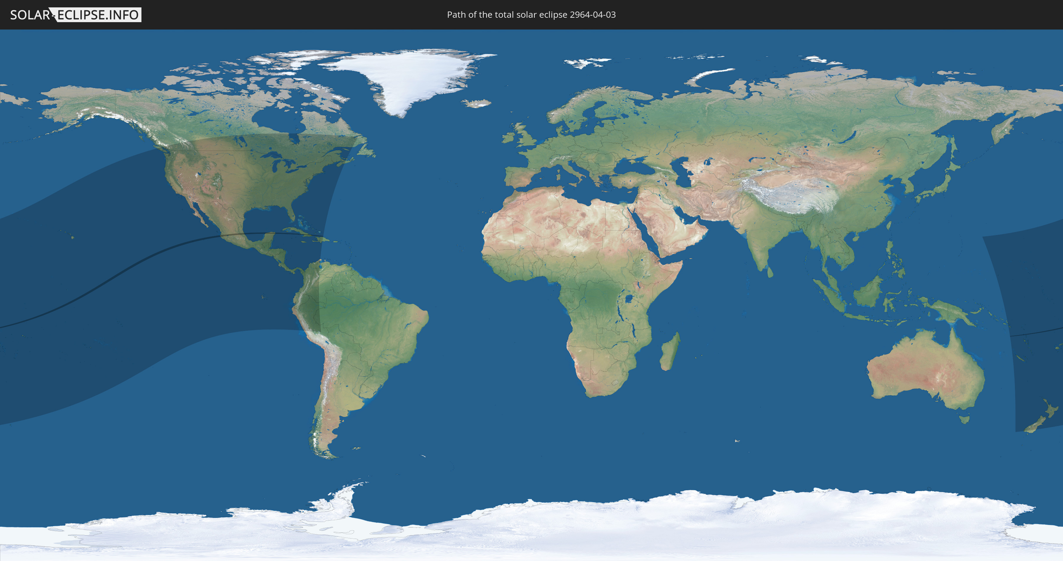
Die Sonnenfinsternis am 04/03/2964 kann man in 43 Ländern als partielle Sonnenfinsternis beobachten.
Der Finsternispfad verläuft durch 3 Länder. Nur in diesen Ländern ist sie als total Sonnenfinsternis zu sehen.
In den folgenden Ländern ist die Sonnenfinsternis total zu sehen
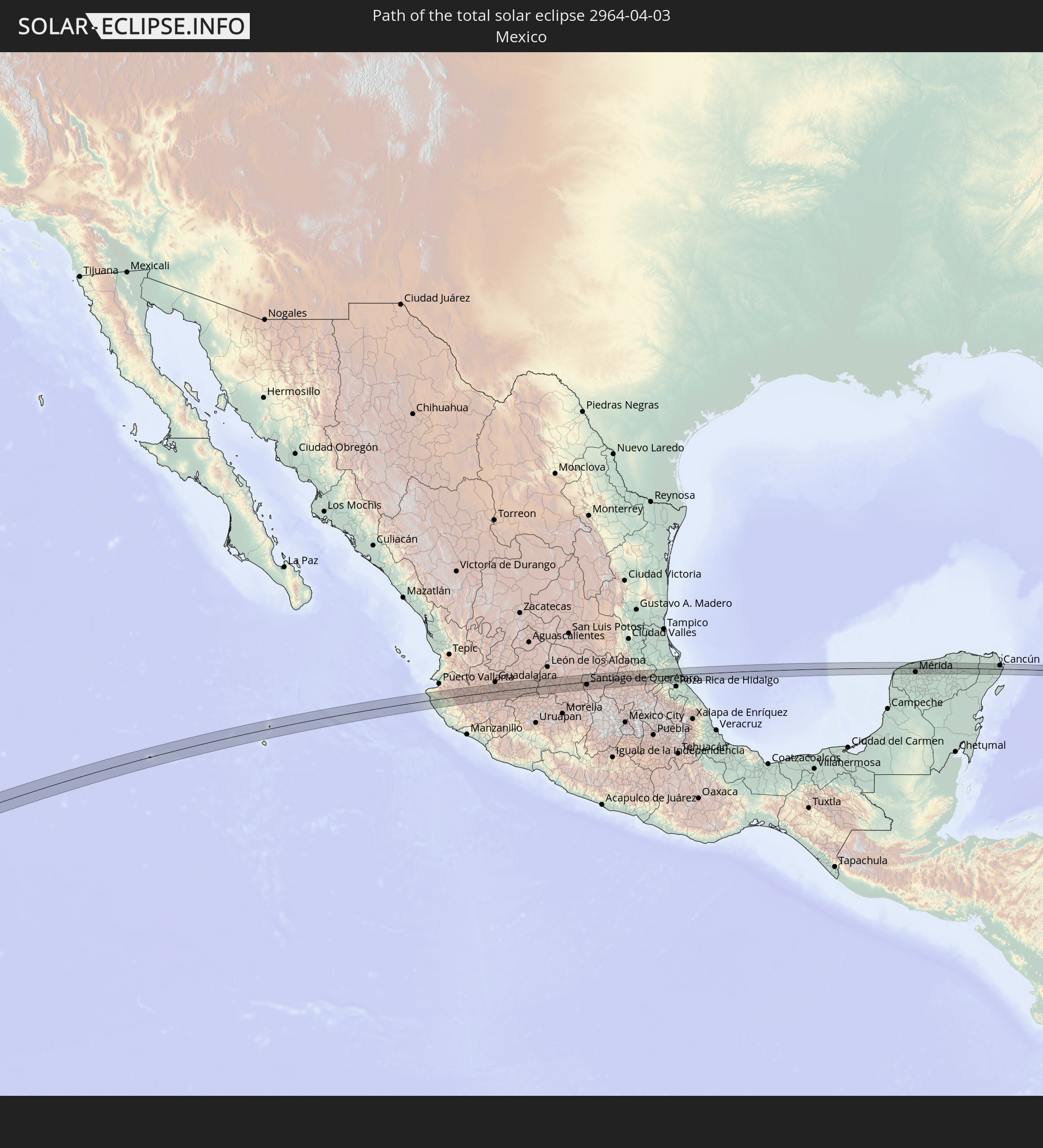 Mexico
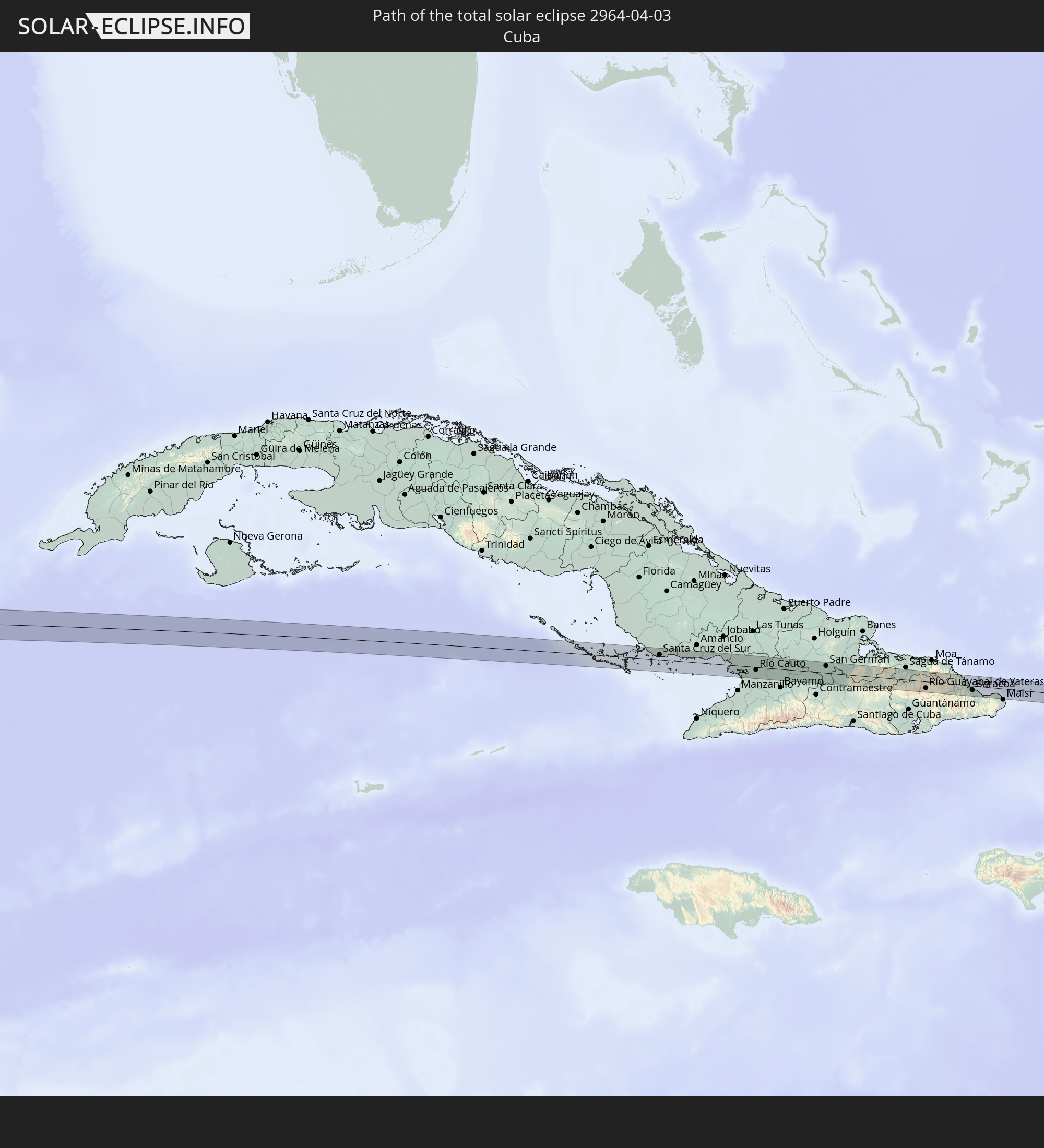 Cuba
Cuba
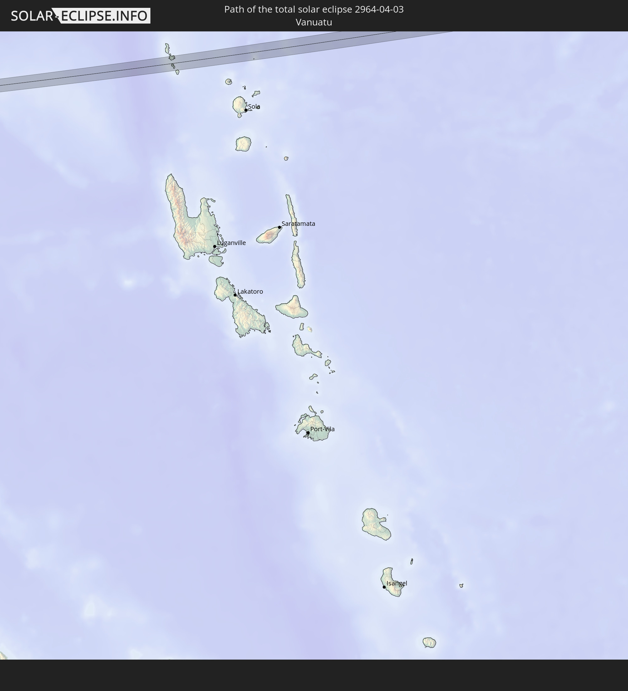 Vanuatu
In den folgenden Ländern ist die Sonnenfinsternis partiell zu sehen
 Fiji
Fiji
 United States
 New Zealand
 United States Minor Outlying Islands
 Wallis and Futuna
 Tonga
Tonga
 Kiribati
 Samoa
Samoa
 Tokelau
 American Samoa
 Niue
Niue
 Cook Islands
 French Polynesia
 Canada
 Pitcairn Islands
 Mexico
 Guatemala
 Ecuador
 El Salvador
 Honduras
 Belize
 Nicaragua
 Costa Rica
 Cuba
Cuba
 Panama
 Colombia
 Cayman Islands
 Peru
Peru
 The Bahamas
 Jamaica
 Haiti
Haiti
 Brazil
 Venezuela
 Turks and Caicos Islands
 Dominican Republic
 Federated States of Micronesia
 Solomon Islands
 New Caledonia
 Marshall Islands
 Vanuatu
 Nauru
Nauru
 Norfolk Island
 Tuvalu
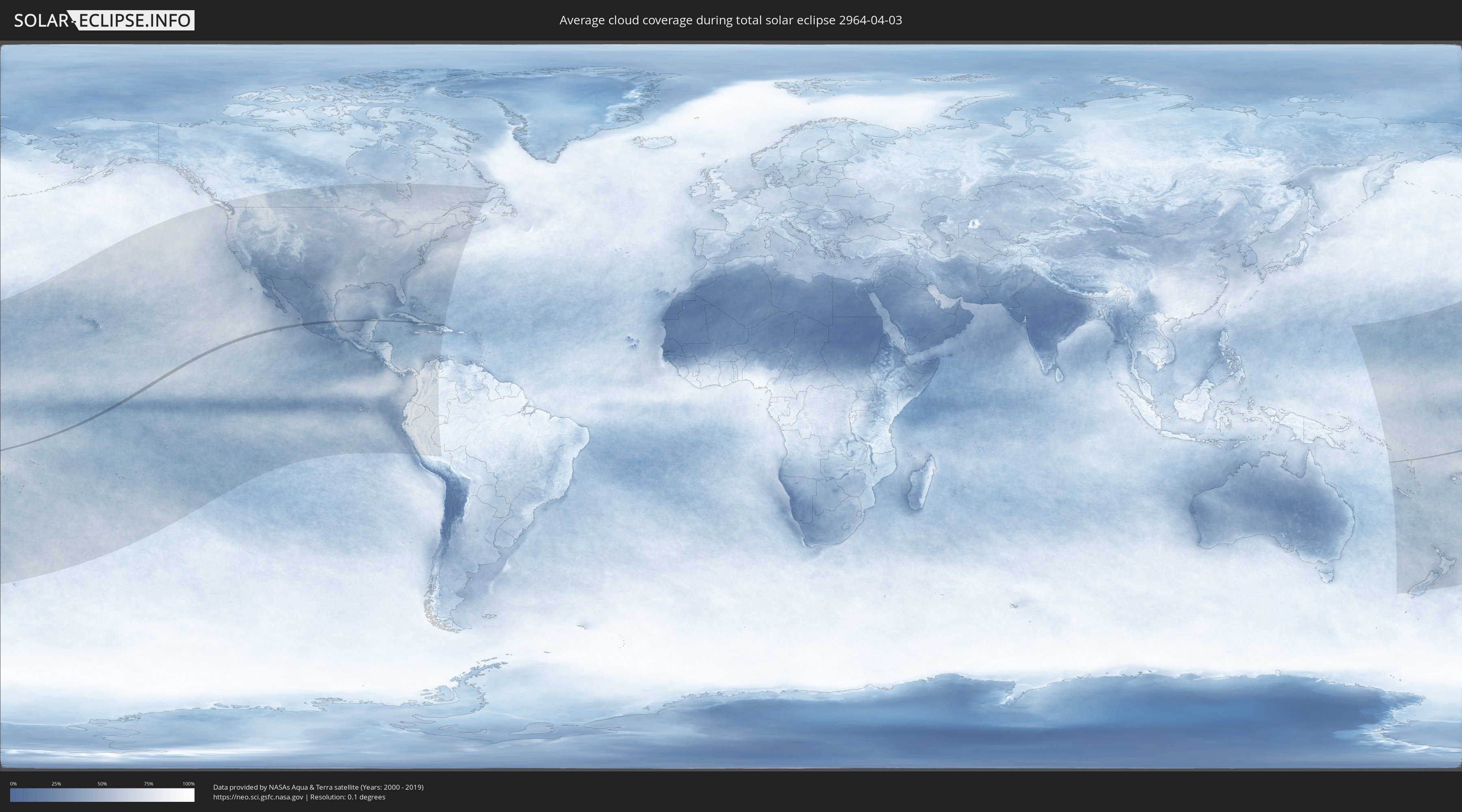
How will be the weather during the total solar eclipse on 04/03/2964?
Where is the best place to see the total solar eclipse of 04/03/2964?
The following maps show the average cloud coverage for the day of the total solar eclipse.
With the help of these maps, it is possible to find the place along the eclipse path, which has the best
chance of a cloudless sky.
Nevertheless, you should consider local circumstances and inform about the weather of your chosen
observation site.
The data is provided by NASAs satellites
AQUA and TERRA.
The cloud maps are averaged over a period of 19 years (2000 - 2019).

Detailed country maps
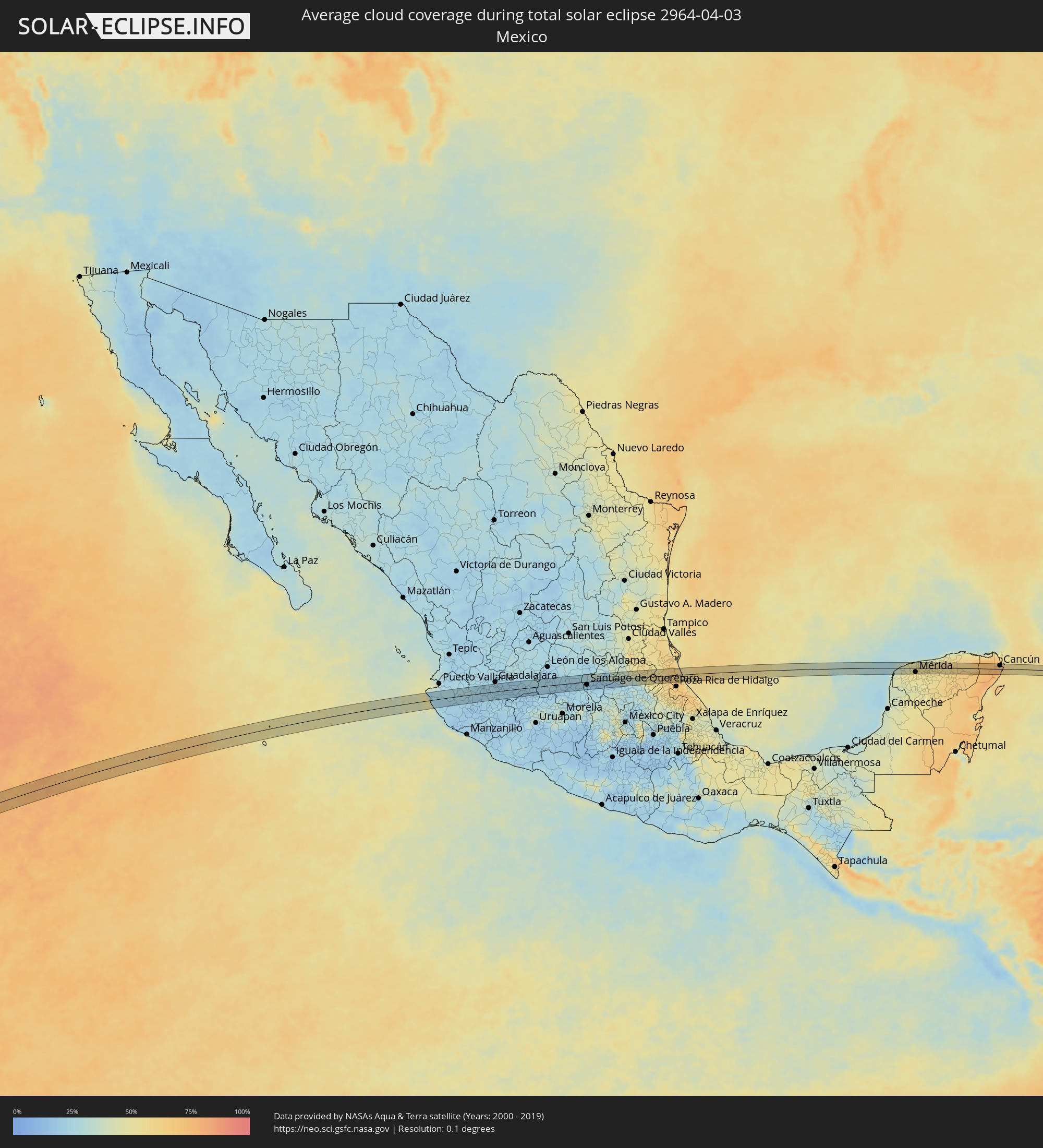 Mexico
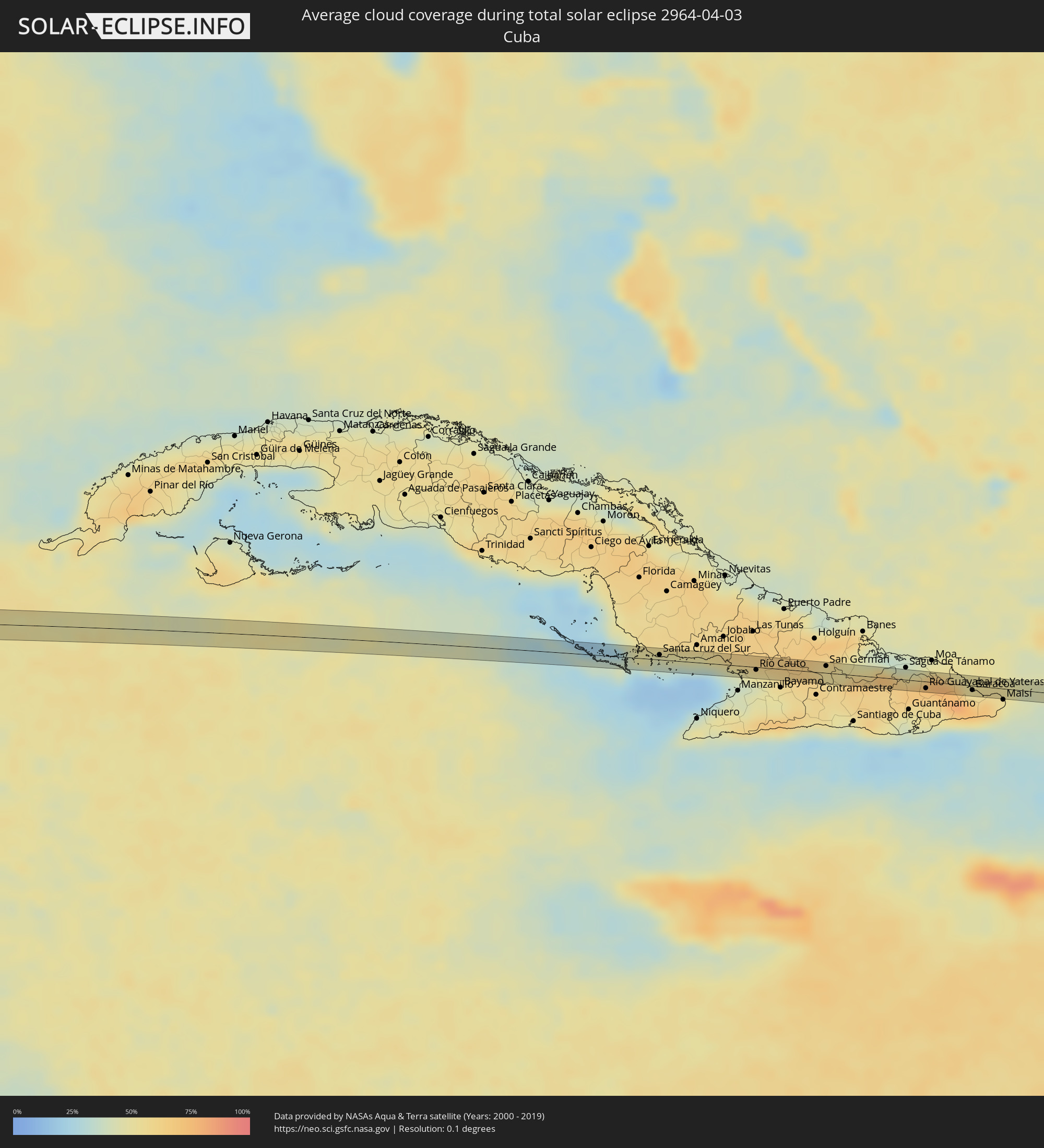 Cuba
Cuba
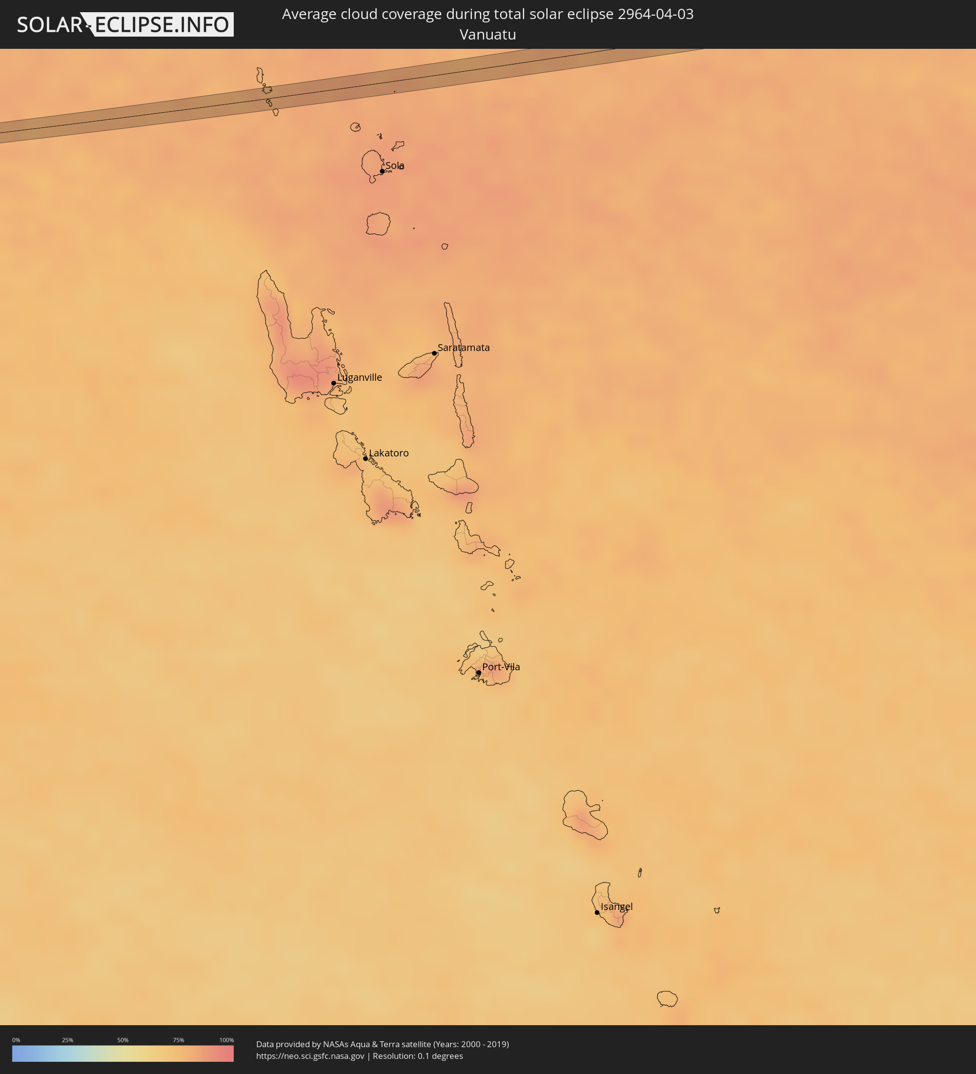 Vanuatu
Cities inside the path of the eclipse
The following table shows all locations with a population of more than 5,000 inside the eclipse path. Cities which have more than 100,000 inhabitants are marked bold. A click at the locations opens a detailed map.
| City | Type | Eclipse duration | Local time of max. eclipse | Distance to central line | Ø Cloud coverage |
|
Tomatlán, Jalisco
|
total | - | 16:31:21 UTC-06:00 | 23 km | 25% |
|
Talpa de Allende, Jalisco
|
total | - | 16:32:04 UTC-06:00 | 20 km | 25% |
|
El Salto, Jalisco
|
total | - | 16:32:30 UTC-06:00 | 10 km | 26% |
|
Ayutla, Jalisco
|
total | - | 16:32:41 UTC-06:00 | 15 km | 21% |
|
Tecolotlán, Jalisco
|
total | - | 16:33:07 UTC-06:00 | 11 km | 19% |
|
San Martín Hidalgo, Jalisco
|
total | - | 16:33:19 UTC-06:00 | 13 km | 23% |
|
El Crucero de Santa María, Jalisco
|
total | - | 16:33:24 UTC-06:00 | 7 km | 23% |
|
Cocula, Jalisco
|
total | - | 16:33:27 UTC-06:00 | 4 km | 23% |
|
Zacoalco de Torres, Jalisco
|
total | - | 16:33:46 UTC-06:00 | 14 km | 24% |
|
Santa Cruz de las Flores, Jalisco
|
total | - | 16:33:54 UTC-06:00 | 13 km | 22% |
|
Lomas de San Agustín, Jalisco
|
total | - | 16:33:57 UTC-06:00 | 18 km | 22% |
|
Nicolás R Casillas, Jalisco
|
total | - | 16:33:58 UTC-06:00 | 20 km | 22% |
|
Tlajomulco de Zúñiga, Jalisco
|
total | - | 16:33:59 UTC-06:00 | 12 km | 22% |
|
Santa Anita, Jalisco
|
total | - | 16:33:59 UTC-06:00 | 20 km | 22% |
|
La Tijera, Jalisco
|
total | - | 16:34:00 UTC-06:00 | 23 km | 22% |
|
Santa Anita, Jalisco
|
total | - | 16:34:00 UTC-06:00 | 20 km | 22% |
|
Santa Cruz del Valle, Jalisco
|
total | - | 16:34:00 UTC-06:00 | 18 km | 22% |
|
Jocotepec, Jalisco
|
total | - | 16:33:58 UTC-06:00 | 10 km | 21% |
|
Lomas del Sur, Jalisco
|
total | - | 16:34:01 UTC-06:00 | 13 km | 22% |
|
San Sebastián el Grande, Jalisco
|
total | - | 16:34:01 UTC-06:00 | 16 km | 22% |
|
Villas de la Hacienda [Fraccionamiento], Jalisco
|
total | - | 16:34:04 UTC-06:00 | 17 km | 22% |
|
Hacienda Santa Fe, Jalisco
|
total | - | 16:34:04 UTC-06:00 | 16 km | 22% |
|
Real del Valle (El Paraíso) [Fraccionamiento], Jalisco
|
total | - | 16:34:05 UTC-06:00 | 18 km | 22% |
|
Valle Dorado Inn, Jalisco
|
total | - | 16:34:06 UTC-06:00 | 16 km | 22% |
|
Las Pintas de Arriba, Jalisco
|
total | - | 16:34:09 UTC-06:00 | 21 km | 21% |
|
El Quince, Jalisco
|
total | - | 16:34:12 UTC-06:00 | 17 km | 22% |
|
El Verde, Jalisco
|
total | - | 16:34:13 UTC-06:00 | 18 km | 21% |
|
Rancho Alegre [Fraccionamiento], Jalisco
|
total | - | 16:34:14 UTC-06:00 | 9 km | 22% |
|
Ajijic, Jalisco
|
total | - | 16:34:13 UTC-06:00 | 10 km | 20% |
|
La Alameda, Jalisco
|
total | - | 16:34:15 UTC-06:00 | 11 km | 22% |
|
San José del Castillo, Jalisco
|
total | - | 16:34:16 UTC-06:00 | 13 km | 22% |
|
Los Olivos, Jalisco
|
total | - | 16:34:15 UTC-06:00 | 5 km | 22% |
|
Tonalá, Jalisco
|
total | - | 16:34:17 UTC-06:00 | 25 km | 20% |
|
Galaxia Bonito Jalisco, Jalisco
|
total | - | 16:34:18 UTC-06:00 | 12 km | 22% |
|
Centro de Readaptación Social, Jalisco
|
total | - | 16:34:20 UTC-06:00 | 17 km | 20% |
|
Chapala, Jalisco
|
total | - | 16:34:18 UTC-06:00 | 11 km | 22% |
|
Juanacatlán, Jalisco
|
total | - | 16:34:21 UTC-06:00 | 12 km | 22% |
|
Atotonilquillo, Jalisco
|
total | - | 16:34:24 UTC-06:00 | 2 km | 19% |
|
Zapotlanejo, Jalisco
|
total | - | 16:34:30 UTC-06:00 | 23 km | 20% |
|
Poncitlán, Jalisco
|
total | - | 16:34:40 UTC-06:00 | 5 km | 19% |
|
Tototlán, Jalisco
|
total | - | 16:34:51 UTC-06:00 | 11 km | 21% |
|
Ocotlán, Jalisco
|
total | - | 16:34:51 UTC-06:00 | 10 km | 19% |
|
Jamay, Jalisco
|
total | - | 16:34:56 UTC-06:00 | 18 km | 17% |
|
La Barca, Jalisco
|
total | - | 16:35:09 UTC-06:00 | 20 km | 19% |
|
Atotonilco el Alto, Jalisco
|
total | - | 16:35:14 UTC-06:00 | 9 km | 21% |
|
Vista Hermosa de Negrete, Michoacán
|
total | - | 16:35:14 UTC-06:00 | 23 km | 19% |
|
Arandas, Jalisco
|
total | - | 16:35:27 UTC-06:00 | 24 km | 24% |
|
Tanhuato de Guerrero, Michoacán
|
total | - | 16:35:25 UTC-06:00 | 23 km | 19% |
|
Yurécuaro, Michoacán
|
total | - | 16:35:29 UTC-06:00 | 18 km | 19% |
|
Degollado, Jalisco
|
total | - | 16:35:41 UTC-06:00 | 5 km | 20% |
|
La Piedad, Michoacán
|
total | - | 16:35:49 UTC-06:00 | 20 km | 20% |
|
Santa Ana Pacueco, Guanajuato
|
total | - | 16:35:50 UTC-06:00 | 20 km | 20% |
|
Ciudad Manuel Doblado, Guanajuato
|
total | - | 16:35:57 UTC-06:00 | 22 km | 25% |
|
Pénjamo, Guanajuato
|
total | - | 16:36:13 UTC-06:00 | 13 km | 18% |
|
Cuerámaro, Guanajuato
|
total | - | 16:36:18 UTC-06:00 | 8 km | 24% |
|
Abasolo, Guanajuato
|
total | - | 16:36:28 UTC-06:00 | 13 km | 17% |
|
Irapuato, Guanajuato
|
total | - | 16:36:42 UTC-06:00 | 10 km | 20% |
|
Valle de Santiago, Guanajuato
|
total | - | 16:36:52 UTC-06:00 | 23 km | 22% |
|
Salamanca, Guanajuato
|
total | - | 16:36:53 UTC-06:00 | 3 km | 18% |
|
Valtierrilla, Guanajuato
|
total | - | 16:36:58 UTC-06:00 | 9 km | 19% |
|
Santa Cruz de Juventino Rosas, Guanajuato
|
total | - | 16:37:08 UTC-06:00 | 2 km | 20% |
|
Cortazar, Guanajuato
|
total | - | 16:37:10 UTC-06:00 | 16 km | 20% |
|
Celaya, Guanajuato
|
total | - | 16:37:21 UTC-06:00 | 13 km | 23% |
|
San Juan de la Vega, Guanajuato
|
total | - | 16:37:25 UTC-06:00 | 2 km | 21% |
|
Comonfort, Guanajuato
|
total | - | 16:37:26 UTC-06:00 | 9 km | 20% |
|
Rincón de Tamayo, Guanajuato
|
total | - | 16:37:25 UTC-06:00 | 24 km | 22% |
|
San Miguel Octopan, Guanajuato
|
total | - | 16:37:26 UTC-06:00 | 8 km | 21% |
|
Empalme Escobedo, Guanajuato
|
total | - | 16:37:26 UTC-06:00 | 3 km | 20% |
|
Apaseo el Alto, Guanajuato
|
total | - | 16:37:34 UTC-06:00 | 22 km | 24% |
|
Santa Rosa Jauregui, Querétaro
|
total | - | 16:37:48 UTC-06:00 | 8 km | 19% |
|
Venceremos, Querétaro
|
total | - | 16:37:51 UTC-06:00 | 14 km | 19% |
|
Santiago de Querétaro, Querétaro
|
total | - | 16:37:52 UTC-06:00 | 10 km | 19% |
|
La Cañada, Querétaro
|
total | - | 16:37:56 UTC-06:00 | 8 km | 19% |
|
Pedro Escobedo, Querétaro
|
total | - | 16:38:09 UTC-06:00 | 22 km | 22% |
|
Ezequiel Montes, Querétaro
|
total | - | 16:38:26 UTC-06:00 | 6 km | 18% |
|
Tequisquiapan, Querétaro
|
total | - | 16:38:26 UTC-06:00 | 21 km | 22% |
|
Cadereyta, Querétaro
|
total | - | 16:38:32 UTC-06:00 | 3 km | 18% |
|
Zimapan, Hidalgo
|
total | - | 16:39:02 UTC-06:00 | 2 km | 22% |
|
Zacualtipán, Hidalgo
|
total | - | 16:39:51 UTC-06:00 | 18 km | 33% |
|
Benito Juárez, Hidalgo
|
total | - | 16:40:20 UTC-06:00 | 5 km | 54% |
|
La Ceiba, Veracruz
|
total | - | 16:40:39 UTC-06:00 | 12 km | 59% |
|
Álamo, Veracruz
|
total | - | 16:40:54 UTC-06:00 | 4 km | 63% |
|
Temapache, Veracruz
|
total | - | 16:40:56 UTC-06:00 | 21 km | 66% |
|
Tihuatlan, Veracruz
|
total | - | 16:41:03 UTC-06:00 | 18 km | 68% |
|
Alto Lucero, Veracruz
|
total | - | 16:41:09 UTC-06:00 | 8 km | 63% |
|
Tuxpan de Rodríguez Cano, Veracruz
|
total | - | 16:41:11 UTC-06:00 | 8 km | 63% |
|
Santiago de la Peña, Veracruz
|
total | - | 16:41:15 UTC-06:00 | 7 km | 57% |
|
Hunucmá, Yucatán
|
total | - | 16:47:36 UTC-06:00 | 9 km | 51% |
|
Mérida, Yucatán
|
total | - | 16:47:47 UTC-06:00 | 14 km | 51% |
|
Tixkokob, Yucatán
|
total | - | 16:47:56 UTC-06:00 | 11 km | 54% |
|
Motul, Yucatán
|
total | - | 16:47:59 UTC-06:00 | 1 km | 54% |
|
Dzidzantun, Yucatán
|
total | - | 16:48:08 UTC-06:00 | 17 km | 55% |
|
Izamal, Yucatán
|
total | - | 16:48:11 UTC-06:00 | 18 km | 54% |
|
Buctzotz, Yucatán
|
total | - | 16:48:18 UTC-06:00 | 12 km | 57% |
|
Espita, Yucatán
|
total | - | 16:48:37 UTC-06:00 | 9 km | 63% |
|
Tizimín, Yucatán
|
total | - | 16:48:42 UTC-06:00 | 6 km | 63% |
|
Kantunilkin, Quintana Roo
|
total | - | 17:49:06 UTC-05:00 | 2 km | 71% |
|
Alfredo V. Bonfil, Quintana Roo
|
total | - | 17:49:28 UTC-05:00 | 2 km | 63% |
|
Cancún, Quintana Roo
|
total | - | 17:49:27 UTC-05:00 | 12 km | 66% |
|
Isla Mujeres, Quintana Roo
|
total | - | 17:49:30 UTC-05:00 | 18 km | 61% |
|
Santa Cruz del Sur, Camagüey
|
total | - | 17:52:53 UTC-05:00 | 6 km | 34% |
|
Río Cauto, Granma
|
total | - | 17:53:08 UTC-05:00 | 3 km | 49% |
|
Cauto Cristo, Granma
|
total | - | 17:53:12 UTC-05:00 | 0 km | 60% |
|
San Germán, Holguín
|
total | - | 17:53:15 UTC-05:00 | 8 km | 53% |
|
Río Guayabal de Yateras, Guantánamo
|
total | - | 17:53:27 UTC-05:00 | 8 km | 67% |
|
Baracoa, Guantánamo
|
total | - | 17:53:31 UTC-05:00 | 5 km | 74% |