Totale Sonnenfinsternis vom 20.10.0906
| Wochentag: | Mittwoch |
| Maximale Dauer der Verfinsterung: | 03m37s |
| Maximale Breite des Finsternispfades: | 153 km |
| Saroszyklus: | 106 |
| Bedeckungsgrad: | 100% |
| Magnitude: | 1.0444 |
| Gamma: | -0.2518 |
Wo kann man die Sonnenfinsternis vom 20.10.0906 sehen?
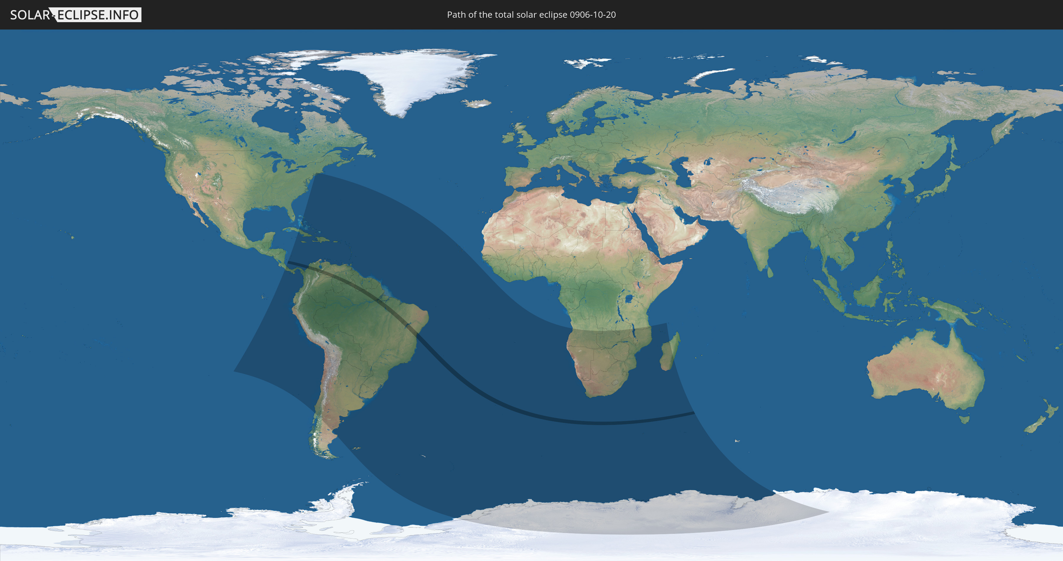
Die Sonnenfinsternis am 20.10.0906 kann man in 64 Ländern als partielle Sonnenfinsternis beobachten.
Der Finsternispfad verläuft durch 4 Länder. Nur in diesen Ländern ist sie als totale Sonnenfinsternis zu sehen.
In den folgenden Ländern ist die Sonnenfinsternis total zu sehen
 Kolumbien
 Brasilien
 Venezuela
 Guyana
In den folgenden Ländern ist die Sonnenfinsternis partiell zu sehen
 Antarktika
 Vereinigte Staaten
 United States Minor Outlying Islands
 Chile
Chile
 Ecuador
 Costa Rica
 Kuba
Kuba
 Panama
 Kolumbien
 Peru
Peru
 Bahamas
 Jamaika
 Haiti
Haiti
 Brasilien
 Argentinien
 Venezuela
 Turks- und Caicosinseln
 Dominikanische Republik
 Aruba
Aruba
 Bolivien
 Puerto Rico
 Amerikanische Jungferninseln
 Bermuda
 Britische Jungferninseln
 Anguilla
 Saint-Martin
 Saint-Barthélemy
 St. Kitts und Nevis
 Paraguay
 Antigua und Barbuda
 Montserrat
 Trinidad und Tobago
 Guadeloupe
 Grenada
 Dominica
 St. Vincent und die Grenadinen
 Falklandinseln
 Guyana
 Martinique
 St. Lucia
 Barbados
 Uruguay
 Suriname
 Französisch-Guayana
 Südgeorgien und die Südlichen Sandwichinseln
 Kap Verde
 St. Helena
 Bouvetinsel
 Angola
 Namibia
 Demokratische Republik Kongo
 Südafrika
 Botswana
 Sambia
 Simbabwe
 Lesotho
 Tansania
 Mosambik
 Swasiland
 Malawi
 Französische Süd- und Antarktisgebiete
 Madagaskar
 Komoren
 Mayotte
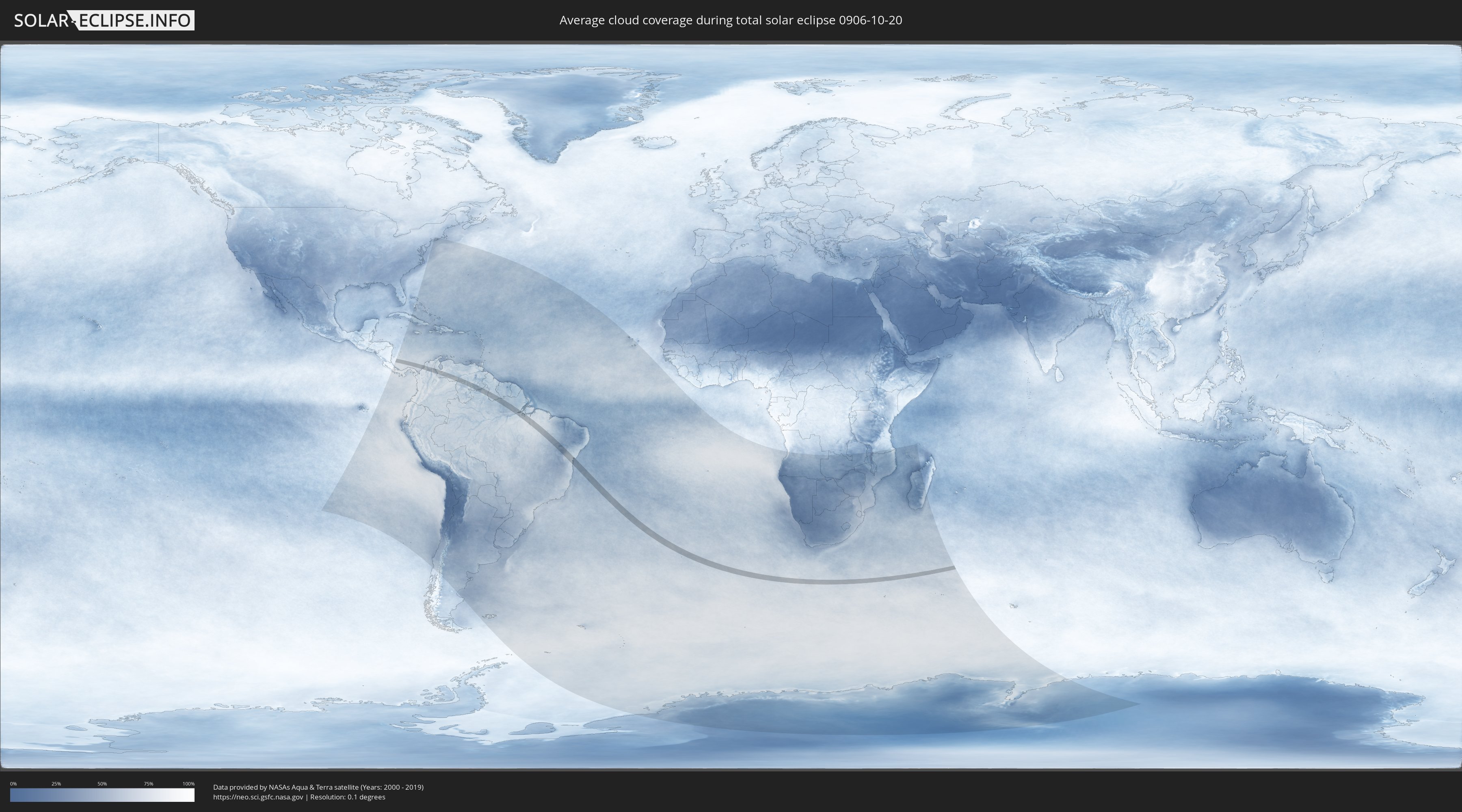
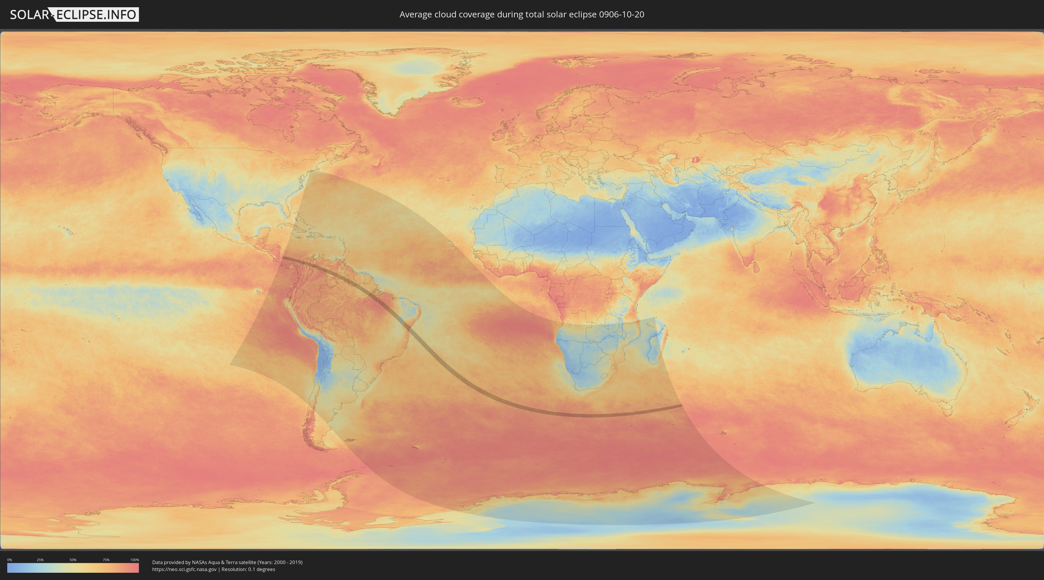
Wie wird das Wetter während der totalen Sonnenfinsternis am 20.10.0906?
Wo ist der beste Ort, um die totale Sonnenfinsternis vom 20.10.0906 zu beobachten?
Die folgenden Karten zeigen die durchschnittliche Bewölkung für den Tag, an dem die totale Sonnenfinsternis
stattfindet. Mit Hilfe der Karten lässt sich der Ort entlang des Finsternispfades eingrenzen,
der die besten Aussichen auf einen klaren wolkenfreien Himmel bietet.
Trotzdem muss man immer lokale Gegenenheiten beachten und sollte sich genau über das Wetter an seinem
gewählten Beobachtungsort informieren.
Die Daten stammen von den beiden NASA-Satelliten
AQUA und TERRA
und wurden über einen Zeitraum von 19 Jahren (2000 - 2019) gemittelt.
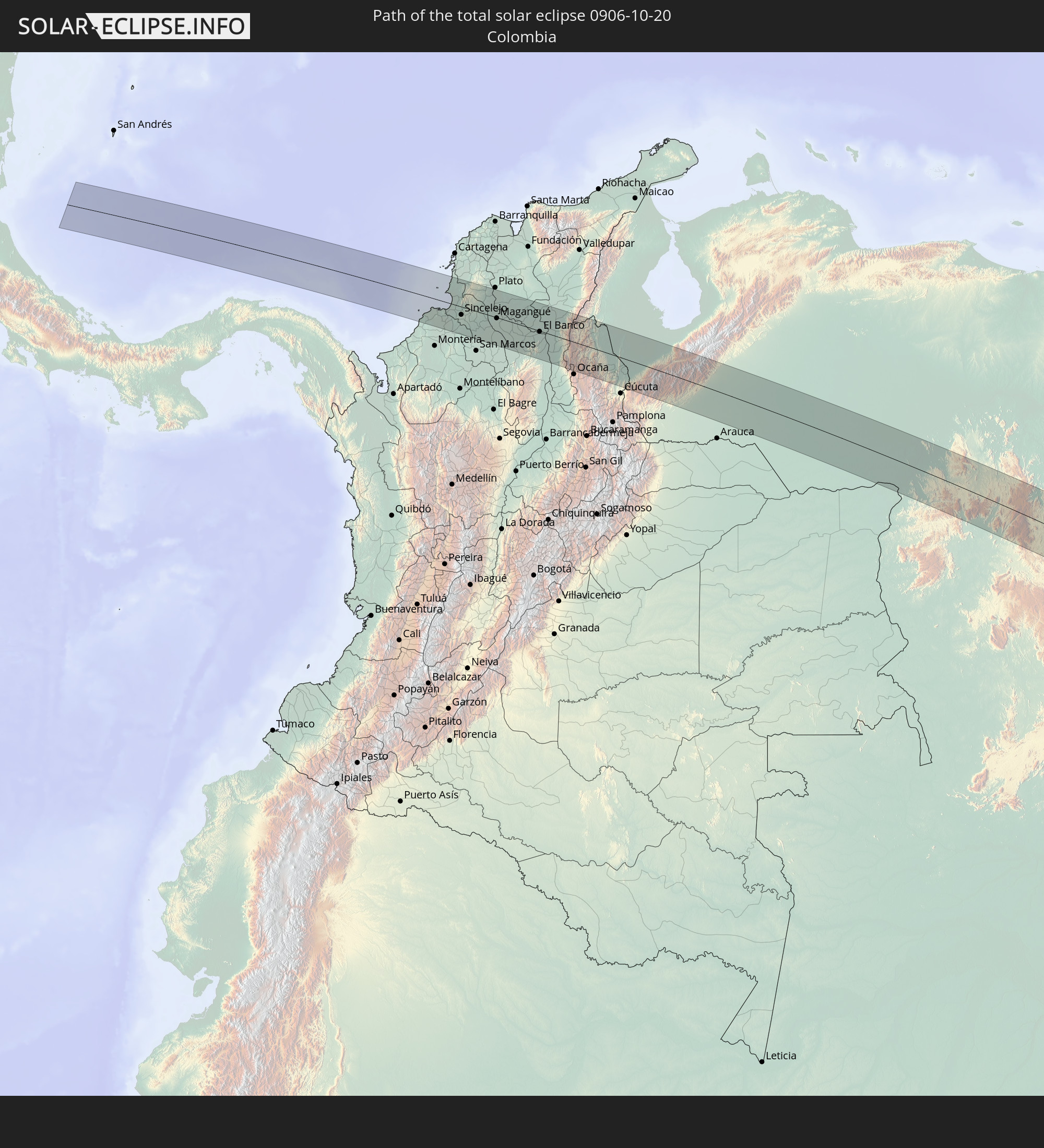
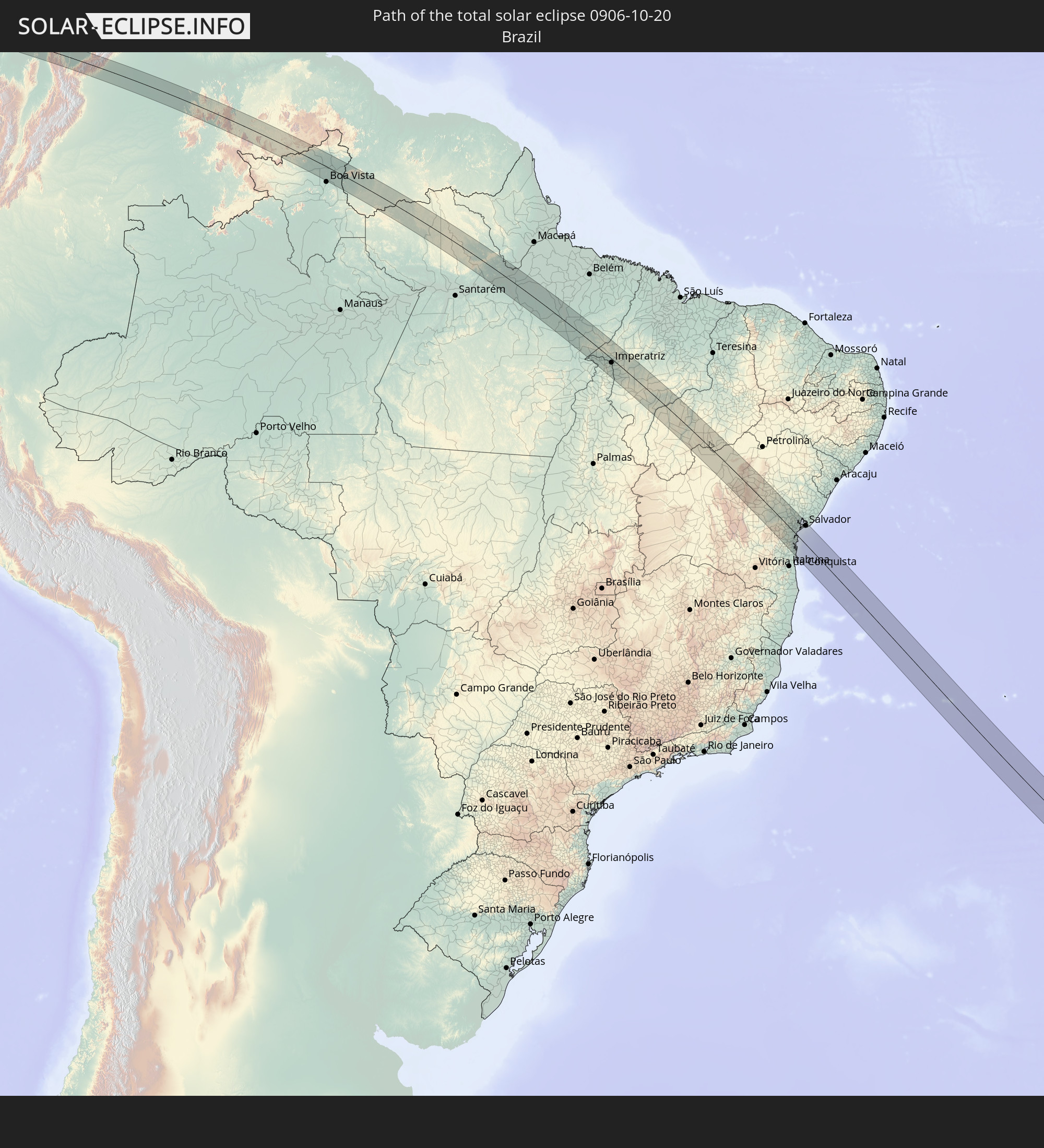
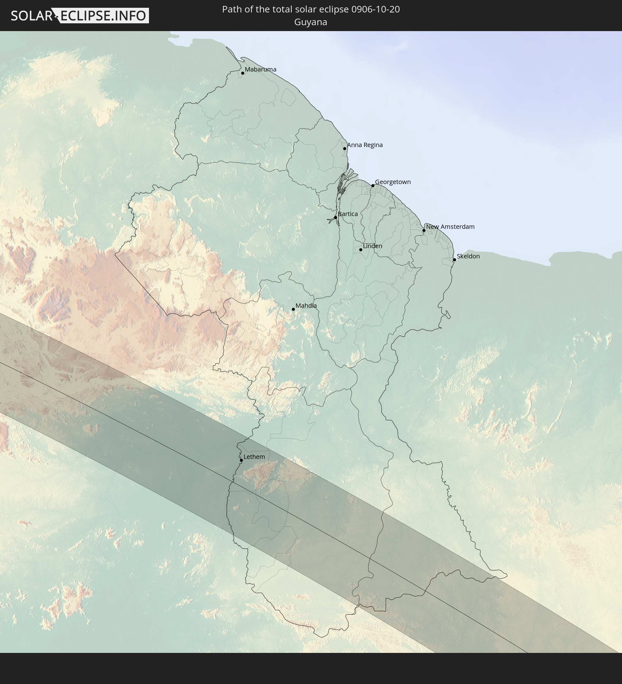
Detaillierte Länderkarten
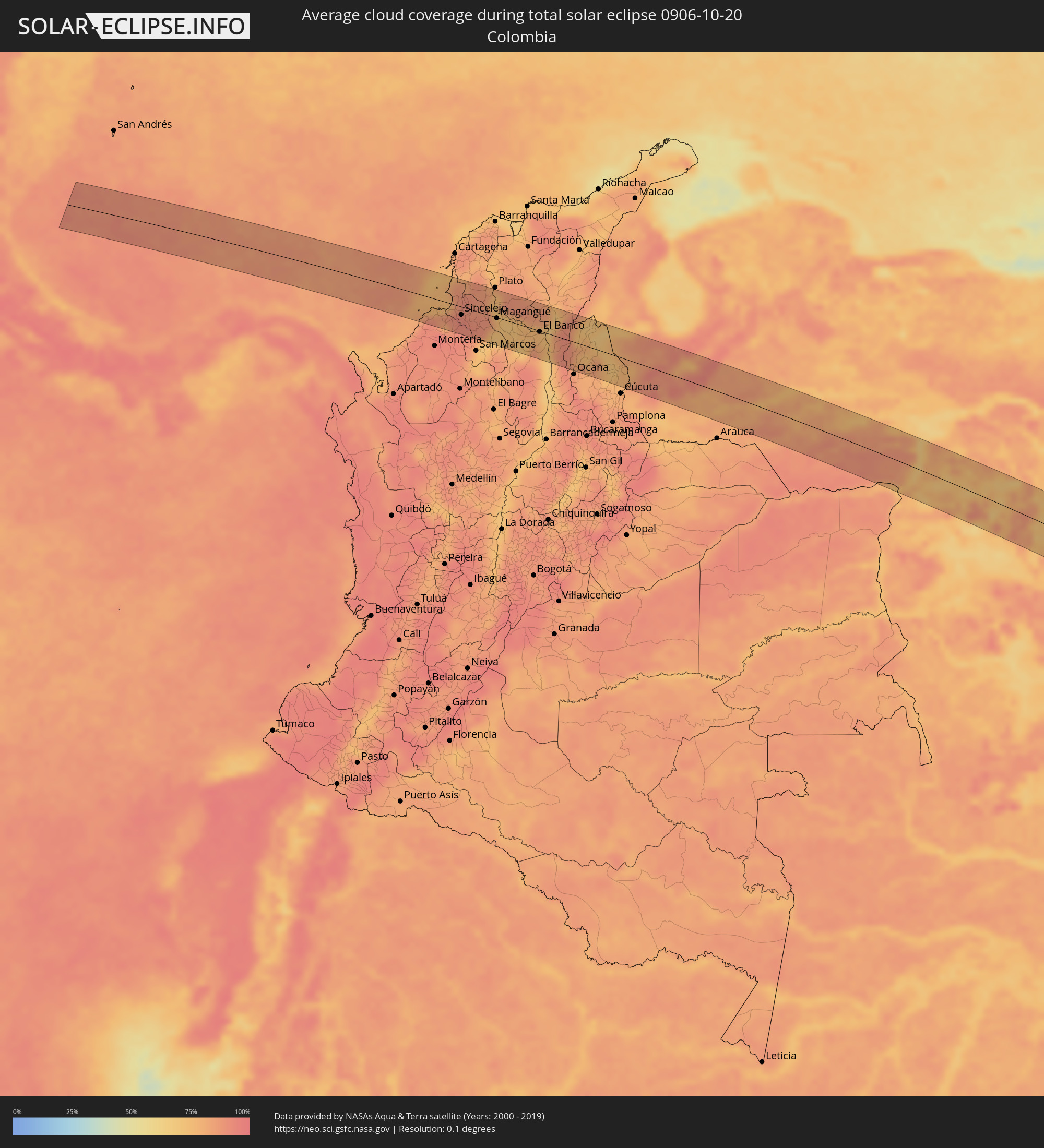 Kolumbien
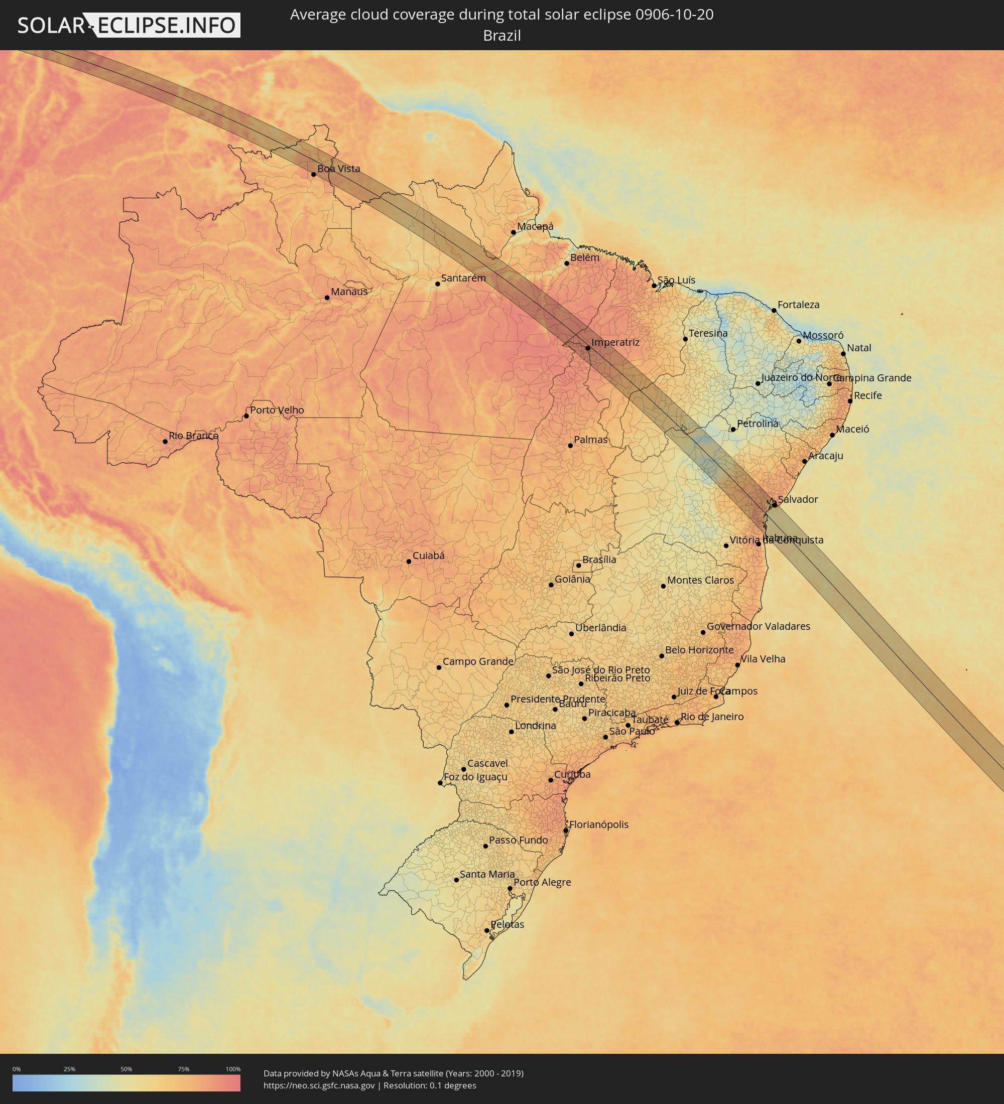 Brasilien
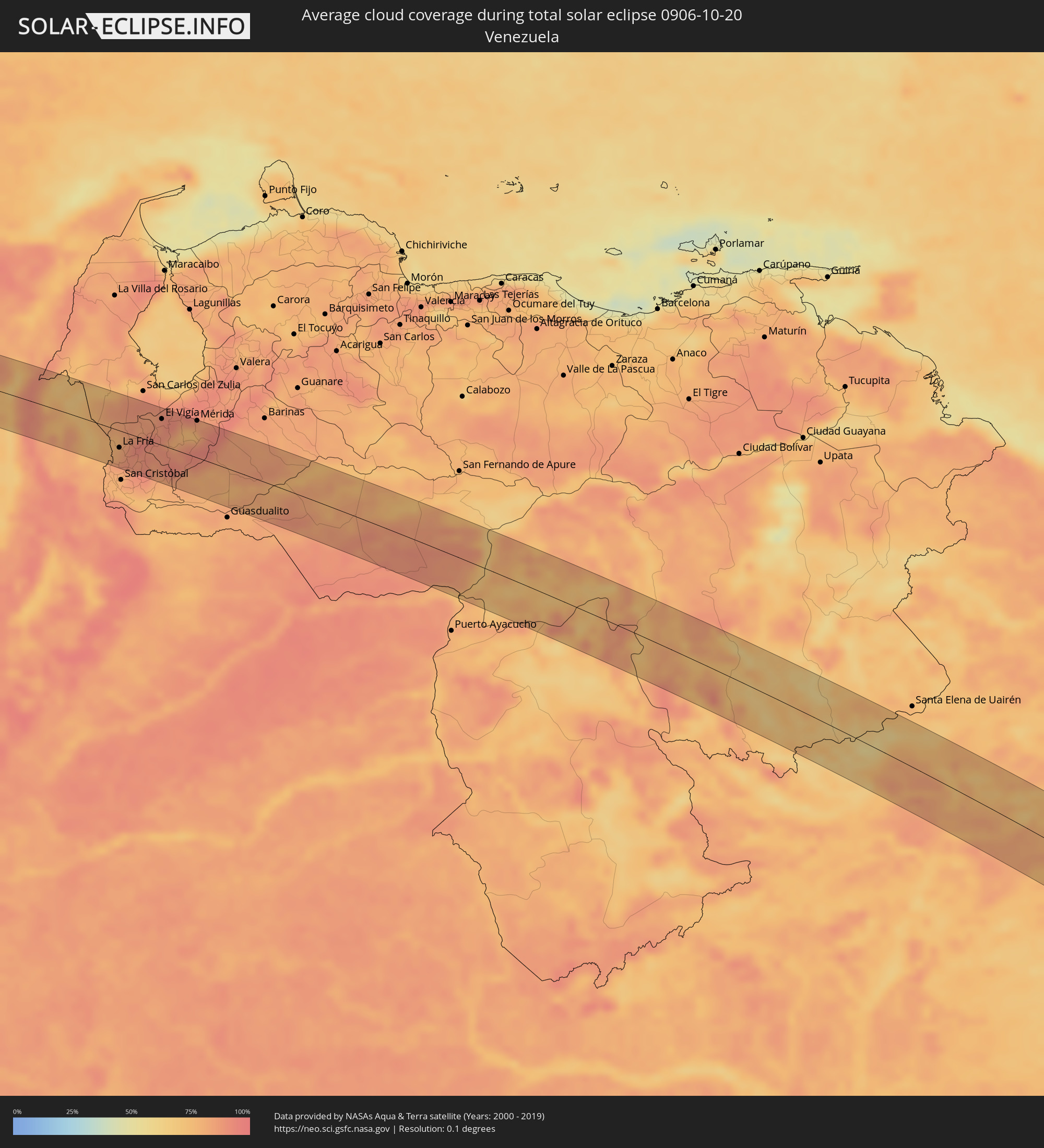 Venezuela
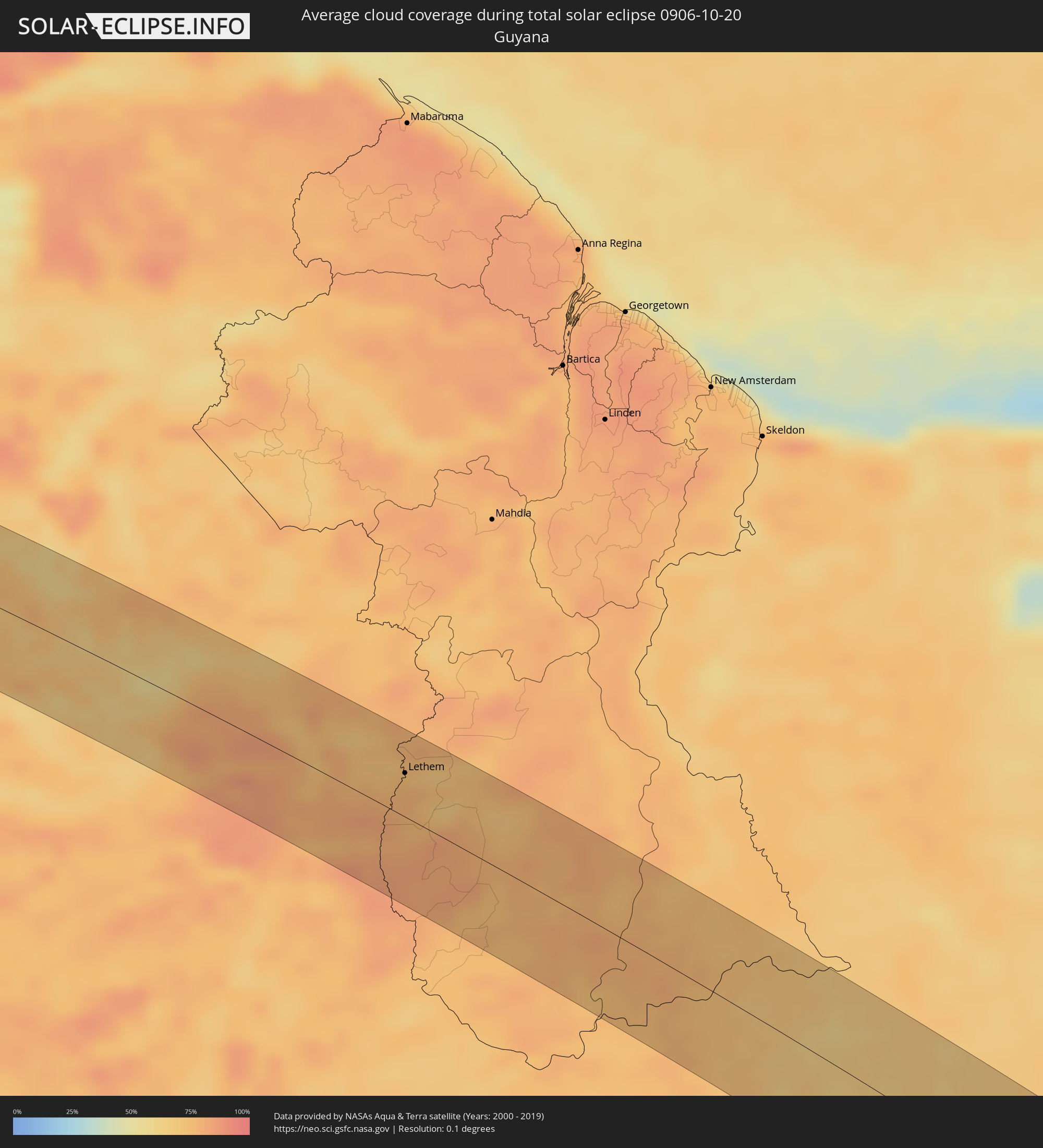 Guyana
Orte im Finsternispfad
Die nachfolgene Tabelle zeigt Städte und Orte mit mehr als 5.000 Einwohnern, die sich im Finsternispfad befinden. Städte mit mehr als 100.000 Einwohnern sind dick gekennzeichnet. Mit einem Klick auf den Ort öffnet sich eine Detailkarte die die Lage des jeweiligen Ortes zusammen mit dem Verlauf der zentralen Finsternis präsentiert.
| Ort | Typ | Dauer der Verfinsterung | Ortszeit bei maximaler Verfinsterung | Entfernung zur Zentrallinie | Ø Bewölkung |
|
San Bernardo del Viento, Córdoba
|
total | - | 06:29:51 UTC-04:56 | 28 km | 85% |
|
Lorica, Córdoba
|
total | - | 06:29:56 UTC-04:56 | 36 km | 87% |
|
San Antero, Córdoba
|
total | - | 06:29:51 UTC-04:56 | 19 km | 85% |
|
Purísima, Córdoba
|
total | - | 06:29:57 UTC-04:56 | 33 km | 79% |
|
Momil, Córdoba
|
total | - | 06:29:57 UTC-04:56 | 31 km | 79% |
|
Tolú, Sucre
|
total | - | 06:29:45 UTC-04:56 | 2 km | 82% |
|
San Onofre, Sucre
|
total | - | 06:29:36 UTC-04:56 | 27 km | 86% |
|
Toluviejo, Sucre
|
total | - | 06:29:48 UTC-04:56 | 1 km | 90% |
|
Chinú, Córdoba
|
total | - | 06:30:03 UTC-04:56 | 37 km | 92% |
|
Sincelejo, Sucre
|
total | - | 06:29:55 UTC-04:56 | 15 km | 93% |
|
Sampués, Sucre
|
total | - | 06:30:00 UTC-04:56 | 28 km | 92% |
|
Corozal, Sucre
|
total | - | 06:29:55 UTC-04:56 | 11 km | 92% |
|
Los Palmitos, Sucre
|
total | - | 06:29:52 UTC-04:56 | 3 km | 90% |
|
San Juan de Betulia, Sucre
|
total | - | 06:29:57 UTC-04:56 | 14 km | 90% |
|
Ovejas, Sucre
|
total | - | 06:29:46 UTC-04:56 | 14 km | 88% |
|
Sincé, Sucre
|
total | - | 06:29:58 UTC-04:56 | 14 km | 90% |
|
San Jacinto, Bolívar
|
total | - | 06:29:34 UTC-04:56 | 49 km | 85% |
|
El Carmen de Bolívar, Bolívar
|
total | - | 06:29:38 UTC-04:56 | 37 km | 88% |
|
San Pedro, Sucre
|
total | - | 06:29:52 UTC-04:56 | 5 km | 89% |
|
Galeras, Sucre
|
total | - | 06:30:02 UTC-04:56 | 20 km | 89% |
|
San Benito Abad, Sucre
|
total | - | 06:30:13 UTC-04:56 | 44 km | 72% |
|
Córdoba, Bolívar
|
total | - | 06:29:45 UTC-04:56 | 33 km | 74% |
|
Zambrano, Magdalena
|
total | - | 06:29:38 UTC-04:56 | 50 km | 75% |
|
Magangué, Bolívar
|
total | - | 06:30:00 UTC-04:56 | 1 km | 79% |
|
Sucre, Sucre
|
total | - | 06:30:19 UTC-04:56 | 46 km | 80% |
|
Cicuco, Bolívar
|
total | - | 06:30:00 UTC-04:56 | 4 km | 73% |
|
Talaigua Viejo, Bolívar
|
total | - | 06:29:58 UTC-04:56 | 12 km | 69% |
|
Santa Ana, Magdalena
|
total | - | 06:29:58 UTC-04:56 | 13 km | 69% |
|
San Zenón, Bolívar
|
total | - | 06:30:01 UTC-04:56 | 7 km | 70% |
|
Pinillos, Bolívar
|
total | - | 06:30:16 UTC-04:56 | 26 km | 76% |
|
Pijiño, Magdalena
|
total | - | 06:29:58 UTC-04:56 | 18 km | 72% |
|
Mompós, Bolívar
|
total | - | 06:30:02 UTC-04:56 | 9 km | 73% |
|
Guamal, Magdalena
|
total | - | 06:30:07 UTC-04:56 | 5 km | 77% |
|
Altos del Rosario, Bolívar
|
total | - | 06:30:23 UTC-04:56 | 30 km | 74% |
|
Barranco de Loba, Bolívar
|
total | - | 06:30:16 UTC-04:56 | 12 km | 79% |
|
Astrea, Cesar
|
total | - | 06:29:53 UTC-04:56 | 51 km | 85% |
|
El Banco, Magdalena
|
total | - | 06:30:15 UTC-04:56 | 1 km | 75% |
|
Río Viejo, Bolívar
|
total | - | 06:30:34 UTC-04:56 | 41 km | 67% |
|
Chimichagua, Cesar
|
total | - | 06:30:04 UTC-04:56 | 31 km | 76% |
|
La Gloria, Cesar
|
total | - | 06:30:33 UTC-04:56 | 36 km | 67% |
|
Pelaya, Cesar
|
total | - | 06:30:31 UTC-04:56 | 24 km | 84% |
|
Pailitas, Cesar
|
total | - | 06:30:19 UTC-04:56 | 6 km | 89% |
|
Chiriguaná, Cesar
|
total | - | 06:30:01 UTC-04:56 | 49 km | 75% |
|
Curumaní, Cesar
|
total | - | 06:30:08 UTC-04:56 | 34 km | 91% |
|
El Carmen, Norte de Santander
|
total | - | 06:30:40 UTC-04:56 | 36 km | 84% |
|
González, Cesar
|
total | - | 06:30:46 UTC-04:56 | 46 km | 85% |
|
Tibú, Norte de Santander
|
total | - | 06:30:39 UTC-04:56 | 3 km | 70% |
|
Puerto Santander, Norte de Santander
|
total | - | 06:30:55 UTC-04:56 | 15 km | 77% |
|
San Juan de Colón, Táchira
|
total | - | 06:59:48 UTC-04:27 | 45 km | 81% |
|
La Fría, Táchira
|
total | - | 06:59:39 UTC-04:27 | 25 km | 85% |
|
El Vigía, Mérida
|
total | - | 06:59:26 UTC-04:27 | 38 km | 87% |
|
Ejido, Mérida
|
total | - | 06:59:33 UTC-04:27 | 46 km | 75% |
|
Mérida, Mérida
|
total | - | 06:59:32 UTC-04:27 | 54 km | 80% |
|
Mucumpiz, Mérida
|
total | - | 06:59:40 UTC-04:27 | 37 km | 90% |
|
Puerto Carreño, Vichada
|
total | - | 06:33:50 UTC-04:56 | 51 km | 73% |
|
Lethem, Upper Takutu-Upper Essequibo
|
total | - | 07:43:32 UTC-03:52 | 32 km | 74% |
|
Almeirim, Pará
|
total | - | 08:33:32 UTC-03:13 | 8 km | 66% |
|
Portel, Pará
|
total | - | 08:35:38 UTC-03:13 | 69 km | 70% |
|
Tucuruí, Pará
|
total | - | 08:39:28 UTC-03:13 | 16 km | 86% |
|
Baião, Pará
|
total | - | 08:37:58 UTC-03:13 | 70 km | 81% |
|
Imperatriz, Maranhão
|
total | - | 09:24:24 UTC-02:34 | 15 km | 86% |
|
Amarante do Maranhão, Maranhão
|
total | - | 09:25:16 UTC-02:34 | 35 km | 86% |
|
Bom Jardim, Maranhão
|
total | - | 09:27:59 UTC-02:34 | 68 km | 80% |
|
Grajaú, Maranhão
|
total | - | 09:26:20 UTC-02:34 | 58 km | 83% |
|
Uruçuí, Piauí
|
total | - | 09:30:32 UTC-02:34 | 57 km | 73% |
|
São Raimundo Nonato, Piauí
|
total | - | 09:35:56 UTC-02:34 | 51 km | 50% |
|
Irecê, Bahia
|
total | - | 09:41:14 UTC-02:34 | 67 km | 38% |
|
Lapão, Bahia
|
total | - | 09:41:25 UTC-02:34 | 71 km | 37% |
|
Cafarnaum, Bahia
|
total | - | 09:42:28 UTC-02:34 | 67 km | 40% |
|
América Dourada, Bahia
|
total | - | 09:42:04 UTC-02:34 | 46 km | 45% |
|
Morro do Chapéu, Bahia
|
total | - | 09:42:36 UTC-02:34 | 32 km | 52% |
|
Tapiramutá, Bahia
|
total | - | 09:43:39 UTC-02:34 | 27 km | 69% |
|
Terra Nova, Bahia
|
total | - | 09:44:49 UTC-02:34 | 57 km | 74% |
|
Miguel Calmon, Bahia
|
total | - | 09:43:07 UTC-02:34 | 21 km | 62% |
|
Piritiba, Bahia
|
total | - | 09:43:45 UTC-02:34 | 1 km | 70% |
|
Jacobina, Bahia
|
total | - | 09:42:46 UTC-02:34 | 47 km | 63% |
|
Ruy Barbosa, Bahia
|
total | - | 09:44:53 UTC-02:34 | 37 km | 76% |
|
Mundo Novo, Bahia
|
total | - | 09:44:06 UTC-02:34 | 3 km | 74% |
|
Itaberaba, Bahia
|
total | - | 09:45:36 UTC-02:34 | 42 km | 76% |
|
Iaçu, Bahia
|
total | - | 09:46:12 UTC-02:34 | 53 km | 76% |
|
Mairi, Bahia
|
total | - | 09:44:15 UTC-02:34 | 34 km | 73% |
|
Capim Grosso, Bahia
|
total | - | 09:43:49 UTC-02:34 | 70 km | 70% |
|
Santa Inês, Bahia
|
total | - | 09:47:45 UTC-02:34 | 63 km | 74% |
|
Ipirá, Bahia
|
total | - | 09:45:40 UTC-02:34 | 31 km | 81% |
|
Amargosa, Bahia
|
total | - | 09:47:32 UTC-02:34 | 26 km | 79% |
|
Gandu, Bahia
|
total | - | 09:49:05 UTC-02:34 | 72 km | 81% |
|
Castro Alves, Bahia
|
total | - | 09:47:16 UTC-02:34 | 8 km | 83% |
|
Santo Antônio de Jesus, Bahia
|
total | - | 09:47:53 UTC-02:34 | 6 km | 82% |
|
Santo Estêvão, Bahia
|
total | - | 09:46:52 UTC-02:34 | 48 km | 80% |
|
Muritiba, Bahia
|
total | - | 09:47:48 UTC-02:34 | 11 km | 82% |
|
Anguera, Bahia
|
total | - | 09:46:20 UTC-02:34 | 70 km | 85% |
|
Ituberá, Bahia
|
total | - | 09:49:32 UTC-02:34 | 44 km | 68% |
|
Camamu, Bahia
|
total | - | 09:50:00 UTC-02:34 | 57 km | 69% |
|
Cruz das Almas, Bahia
|
total | - | 09:47:32 UTC-02:34 | 41 km | 79% |
|
Sobradinho, Bahia
|
total | - | 09:47:51 UTC-02:34 | 29 km | 80% |
|
Valença, Bahia
|
total | - | 09:48:56 UTC-02:34 | 10 km | 69% |
|
Nazaré, Bahia
|
total | - | 09:48:22 UTC-02:34 | 20 km | 80% |
|
Conceição da Feira, Bahia
|
total | - | 09:47:21 UTC-02:34 | 62 km | 77% |
|
Itacaré, Bahia
|
total | - | 09:50:49 UTC-02:34 | 74 km | 60% |
|
São Gonçalo dos Campos, Bahia
|
total | - | 09:47:16 UTC-02:34 | 70 km | 83% |
|
Cachoeira, Bahia
|
total | - | 09:47:35 UTC-02:34 | 57 km | 74% |
|
Maragogipe, Bahia
|
total | - | 09:48:00 UTC-02:34 | 47 km | 69% |
|
Saubara, Bahia
|
total | - | 09:48:08 UTC-02:34 | 62 km | 59% |
|
Itaparica, Bahia
|
total | - | 09:48:33 UTC-02:34 | 58 km | 61% |
|
Madre de Deus, Bahia
|
total | - | 09:48:20 UTC-02:34 | 73 km | 72% |
|
Salvador, Bahia
|
total | - | 09:48:57 UTC-02:34 | 64 km | 62% |