Totale Sonnenfinsternis vom 28.07.-0131
| Wochentag: | Montag |
| Maximale Dauer der Verfinsterung: | 04m14s |
| Maximale Breite des Finsternispfades: | 398 km |
| Saroszyklus: | 82 |
| Bedeckungsgrad: | 100% |
| Magnitude: | 1.0539 |
| Gamma: | -0.8959 |
Wo kann man die Sonnenfinsternis vom 28.07.-0131 sehen?
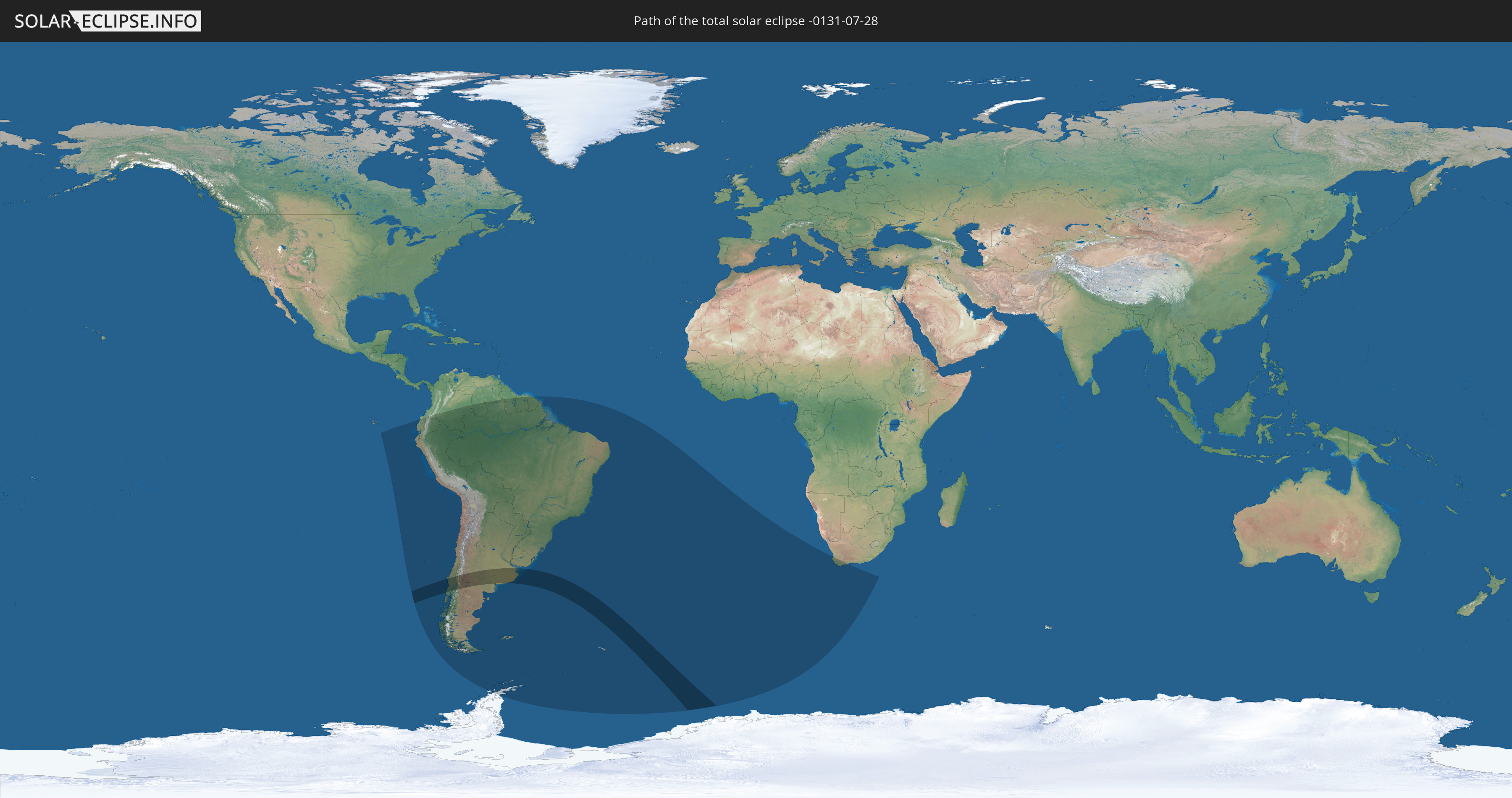
Die Sonnenfinsternis am 28.07.-0131 kann man in 19 Ländern als partielle Sonnenfinsternis beobachten.
Der Finsternispfad verläuft durch 3 Länder. Nur in diesen Ländern ist sie als totale Sonnenfinsternis zu sehen.
In den folgenden Ländern ist die Sonnenfinsternis total zu sehen
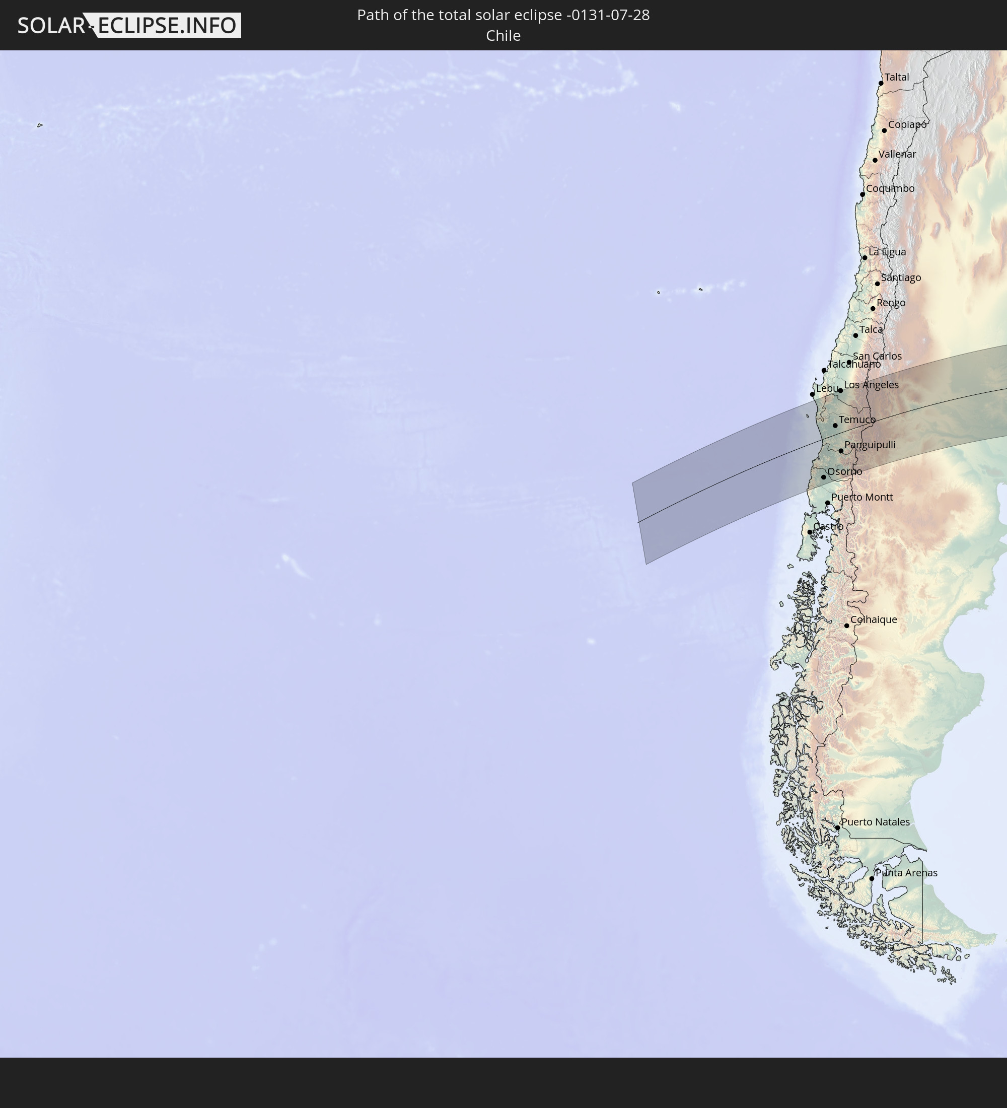 Chile
Chile
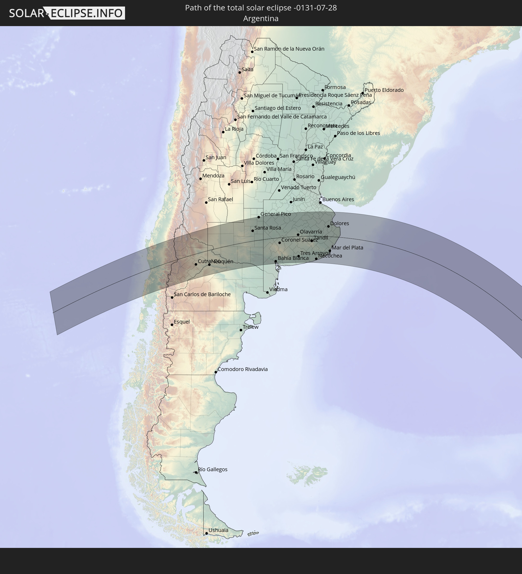 Argentinien
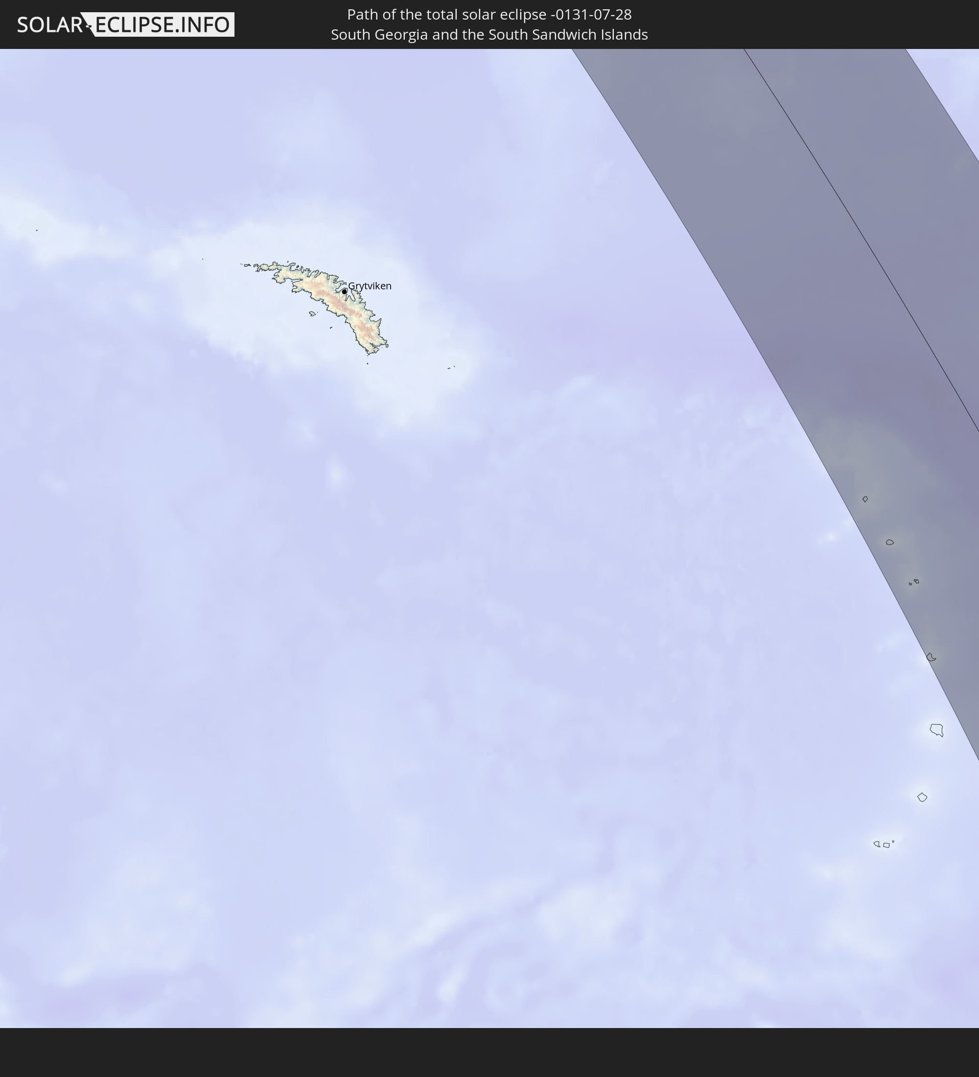 Südgeorgien und die Südlichen Sandwichinseln
In den folgenden Ländern ist die Sonnenfinsternis partiell zu sehen


Wie wird das Wetter während der totalen Sonnenfinsternis am 28.07.-0131?
Wo ist der beste Ort, um die totale Sonnenfinsternis vom 28.07.-0131 zu beobachten?
Die folgenden Karten zeigen die durchschnittliche Bewölkung für den Tag, an dem die totale Sonnenfinsternis
stattfindet. Mit Hilfe der Karten lässt sich der Ort entlang des Finsternispfades eingrenzen,
der die besten Aussichen auf einen klaren wolkenfreien Himmel bietet.
Trotzdem muss man immer lokale Gegenenheiten beachten und sollte sich genau über das Wetter an seinem
gewählten Beobachtungsort informieren.
Die Daten stammen von den beiden NASA-Satelliten
AQUA und TERRA
und wurden über einen Zeitraum von 19 Jahren (2000 - 2019) gemittelt.


Detaillierte Länderkarten
 Chile
Chile
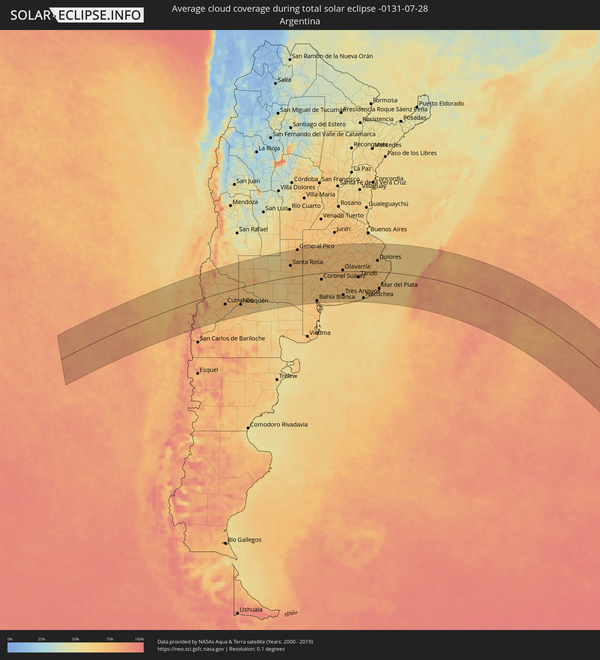 Argentinien
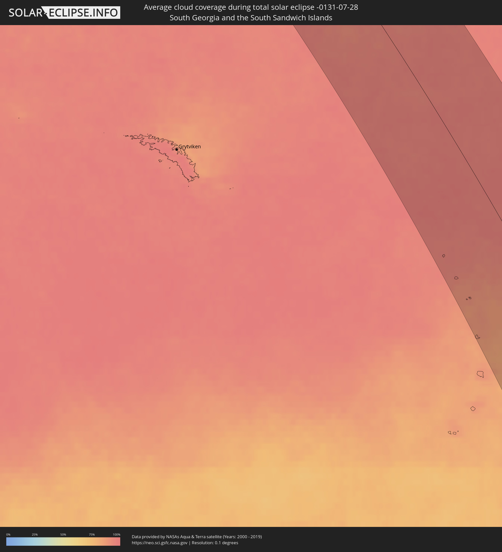 Südgeorgien und die Südlichen Sandwichinseln
Orte im Finsternispfad
Die nachfolgene Tabelle zeigt Städte und Orte mit mehr als 5.000 Einwohnern, die sich im Finsternispfad befinden. Städte mit mehr als 100.000 Einwohnern sind dick gekennzeichnet. Mit einem Klick auf den Ort öffnet sich eine Detailkarte die die Lage des jeweiligen Ortes zusammen mit dem Verlauf der zentralen Finsternis präsentiert.
| Ort | Typ | Dauer der Verfinsterung | Ortszeit bei maximaler Verfinsterung | Entfernung zur Zentrallinie | Ø Bewölkung |
 Cañete, Biobío
|
total | - | 08:04:08 UTC-04:42 | 153 km | 65% |
|
Valdivia, Los Ríos
|
total | - | 08:07:24 UTC-04:42 | 62 km | 81% |
|
Las Animas, Los Lagos
|
total | - | 08:07:25 UTC-04:42 | 62 km | 81% |
|
Carahue, Araucanía
|
total | - | 08:05:45 UTC-04:42 | 51 km | 72% |
|
Osorno, Los Lagos
|
total | - | 08:08:42 UTC-04:42 | 144 km | 81% |
|
La Unión, Los Ríos
|
total | - | 08:08:18 UTC-04:42 | 117 km | 80% |
|
Río Bueno, Los Ríos
|
total | - | 08:08:29 UTC-04:42 | 125 km | 81% |
|
Nueva Imperial, Araucanía
|
total | - | 08:06:00 UTC-04:42 | 41 km | 77% |
|
Angol, Araucanía
|
total | - | 08:04:45 UTC-04:42 | 134 km | 72% |
|
Traiguén, Araucanía
|
total | - | 08:05:30 UTC-04:42 | 85 km | 76% |
|
Pitrufquén, Araucanía
|
total | - | 08:06:40 UTC-04:42 | 7 km | 74% |
|
Loncoche, Araucanía
|
total | - | 08:07:16 UTC-04:42 | 33 km | 77% |
|
Freire, Araucanía
|
total | - | 08:06:38 UTC-04:42 | 10 km | 74% |
|
Temuco, Araucanía
|
total | - | 08:06:20 UTC-04:42 | 31 km | 74% |
|
Lautaro, Araucanía
|
total | - | 08:06:10 UTC-04:42 | 49 km | 73% |
|
Collipulli, Araucanía
|
total | - | 08:05:16 UTC-04:42 | 109 km | 73% |
|
Los Ángeles, Biobío
|
total | - | 08:04:36 UTC-04:42 | 158 km | 73% |
|
Victoria, Araucanía
|
total | - | 08:05:48 UTC-04:42 | 77 km | 73% |
|
Panguipulli, Araucanía
|
total | - | 08:08:00 UTC-04:42 | 71 km | 75% |
|
Mulchén, Biobío
|
total | - | 08:05:06 UTC-04:42 | 129 km | 68% |
|
Villarrica, Araucanía
|
total | - | 08:07:32 UTC-04:42 | 37 km | 74% |
|
Vilcún, Araucanía
|
total | - | 08:06:35 UTC-04:42 | 28 km | 71% |
|
Pucón, Araucanía
|
total | - | 08:07:48 UTC-04:42 | 44 km | 80% |
 San Martín de los Andes, Neuquén Province
|
total | - | 08:35:44 UTC-04:16 | 153 km | 87% |
|
Junín de los Andes, Neuquén Province
|
total | - | 08:35:42 UTC-04:16 | 139 km | 70% |
|
Chos Malal, Neuquén Province
|
total | - | 08:32:32 UTC-04:16 | 112 km | 72% |
|
Zapala, Neuquén Province
|
total | - | 08:35:06 UTC-04:16 | 55 km | 73% |
|
Cutral-Có, Neuquén Province
|
total | - | 08:36:03 UTC-04:16 | 80 km | 72% |
|
Plaza Huincul, Neuquén Province
|
total | - | 08:36:03 UTC-04:16 | 79 km | 72% |
|
Senillosa, Neuquén Province
|
total | - | 08:37:03 UTC-04:16 | 107 km | 72% |
|
Plottier, Neuquén Province
|
total | - | 08:37:12 UTC-04:16 | 107 km | 74% |
|
Centenario, Neuquén Province
|
total | - | 08:37:07 UTC-04:16 | 94 km | 71% |
|
Cinco Saltos, Río Negro Province
|
total | - | 08:37:11 UTC-04:16 | 95 km | 71% |
|
Neuquén, Neuquén Province
|
total | - | 08:37:23 UTC-04:16 | 109 km | 74% |
|
Cipolletti, Río Negro Province
|
total | - | 08:37:26 UTC-04:16 | 108 km | 70% |
|
General Fernández Oro, Río Negro Province
|
total | - | 08:37:32 UTC-04:16 | 112 km | 66% |
|
Allen, Río Negro Province
|
total | - | 08:37:41 UTC-04:16 | 117 km | 66% |
|
Catriel, Río Negro Province
|
total | - | 08:36:02 UTC-04:16 | 1 km | 67% |
|
Veinticinco de Mayo, La Pampa Province
|
total | - | 08:35:58 UTC-04:16 | 11 km | 66% |
|
General Roca, Río Negro Province
|
total | - | 08:38:03 UTC-04:16 | 128 km | 68% |
|
Cervantes, Río Negro Province
|
total | - | 08:38:19 UTC-04:16 | 134 km | 64% |
|
Ingeniero Luis A. Huergo, Río Negro Province
|
total | - | 08:38:32 UTC-04:16 | 141 km | 64% |
|
Villa Regina, Río Negro Province
|
total | - | 08:38:46 UTC-04:16 | 146 km | 65% |
|
Victorica, La Pampa Province
|
total | - | 08:36:22 UTC-04:16 | 138 km | 59% |
|
General Acha, La Pampa Province
|
total | - | 08:39:10 UTC-04:16 | 2 km | 64% |
|
Eduardo Castex, La Pampa Province
|
total | - | 08:37:22 UTC-04:16 | 154 km | 72% |
|
Santa Rosa, La Pampa Province
|
total | - | 08:38:26 UTC-04:16 | 76 km | 70% |
|
General Pico, La Pampa Province
|
total | - | 08:37:42 UTC-04:16 | 175 km | 76% |
|
Guatraché, La Pampa Province
|
total | - | 08:41:01 UTC-04:16 | 49 km | 71% |
|
Bahía Blanca, Buenos Aires
|
total | - | 08:44:18 UTC-04:16 | 179 km | 71% |
|
Coronel Suárez, Buenos Aires
|
total | - | 08:42:52 UTC-04:16 | 42 km | 67% |
|
Coronel Dorrego, Buenos Aires
|
total | - | 08:45:40 UTC-04:16 | 187 km | 68% |
|
Nueve de Julio, Buenos Aires
|
total | - | 08:41:24 UTC-04:16 | 174 km | 73% |
|
Olavarría, Buenos Aires
|
total | - | 08:44:20 UTC-04:16 | 11 km | 72% |
|
Tres Arroyos, Buenos Aires
|
total | - | 08:46:35 UTC-04:16 | 154 km | 69% |
|
Veinticinco de Mayo, Buenos Aires
|
total | - | 08:42:25 UTC-04:16 | 173 km | 70% |
|
Azul, Buenos Aires
|
total | - | 08:44:51 UTC-04:16 | 22 km | 73% |
|
Tandil, Buenos Aires
|
total | - | 08:46:44 UTC-04:16 | 39 km | 72% |
|
Necochea, Buenos Aires
|
total | - | 08:49:08 UTC-04:16 | 176 km | 60% |
|
Dolores, Buenos Aires
|
total | - | 08:47:31 UTC-04:16 | 76 km | 68% |
|
Mar del Plata, Buenos Aires
|
total | - | 08:50:08 UTC-04:16 | 111 km | 70% |
|
Villa Gesell, Buenos Aires
|
total | - | 08:50:00 UTC-04:16 | 26 km | 66% |
|
San Clemente del Tuyú, Buenos Aires
|
total | - | 08:49:06 UTC-04:16 | 77 km | 66% |