Totale Sonnenfinsternis vom 06.12.-0474
| Wochentag: | Sonntag |
| Maximale Dauer der Verfinsterung: | 03m27s |
| Maximale Breite des Finsternispfades: | 213 km |
| Saroszyklus: | 44 |
| Bedeckungsgrad: | 100% |
| Magnitude: | 1.0397 |
| Gamma: | 0.7855 |
Wo kann man die Sonnenfinsternis vom 06.12.-0474 sehen?
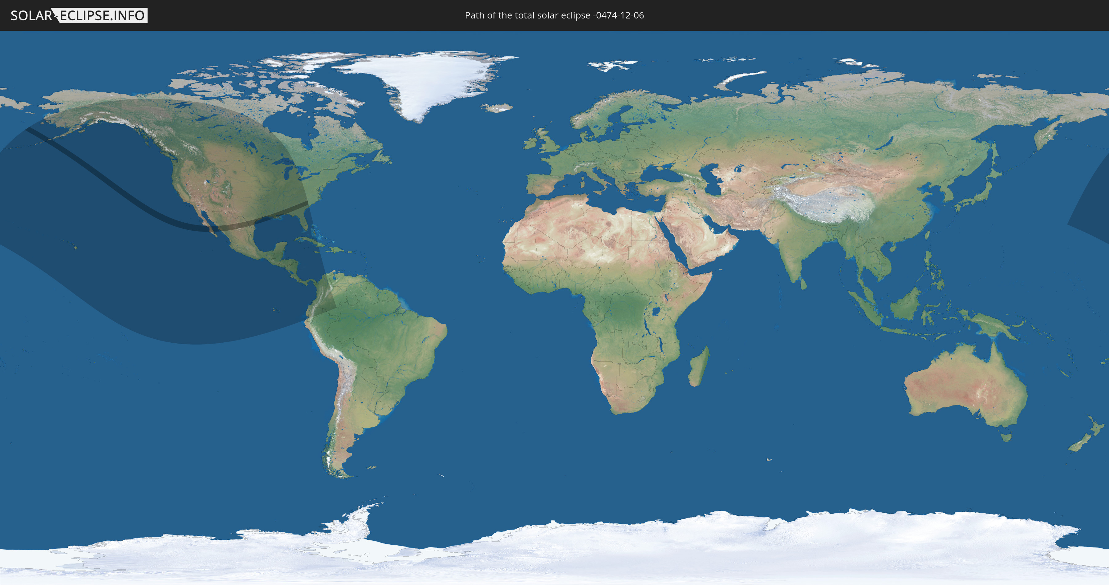
Die Sonnenfinsternis am 06.12.-0474 kann man in 19 Ländern als partielle Sonnenfinsternis beobachten.
Der Finsternispfad verläuft durch 2 Länder. Nur in diesen Ländern ist sie als totale Sonnenfinsternis zu sehen.
In den folgenden Ländern ist die Sonnenfinsternis total zu sehen
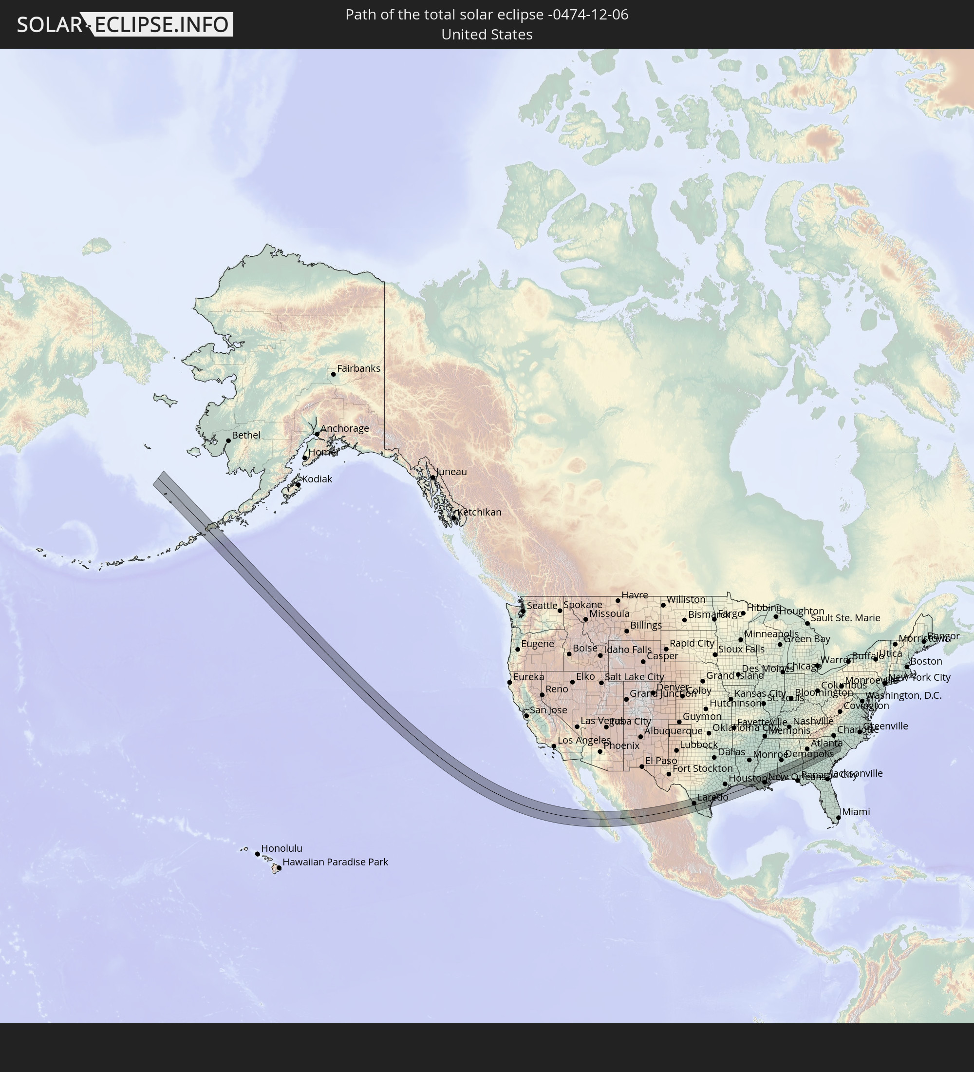 Vereinigte Staaten
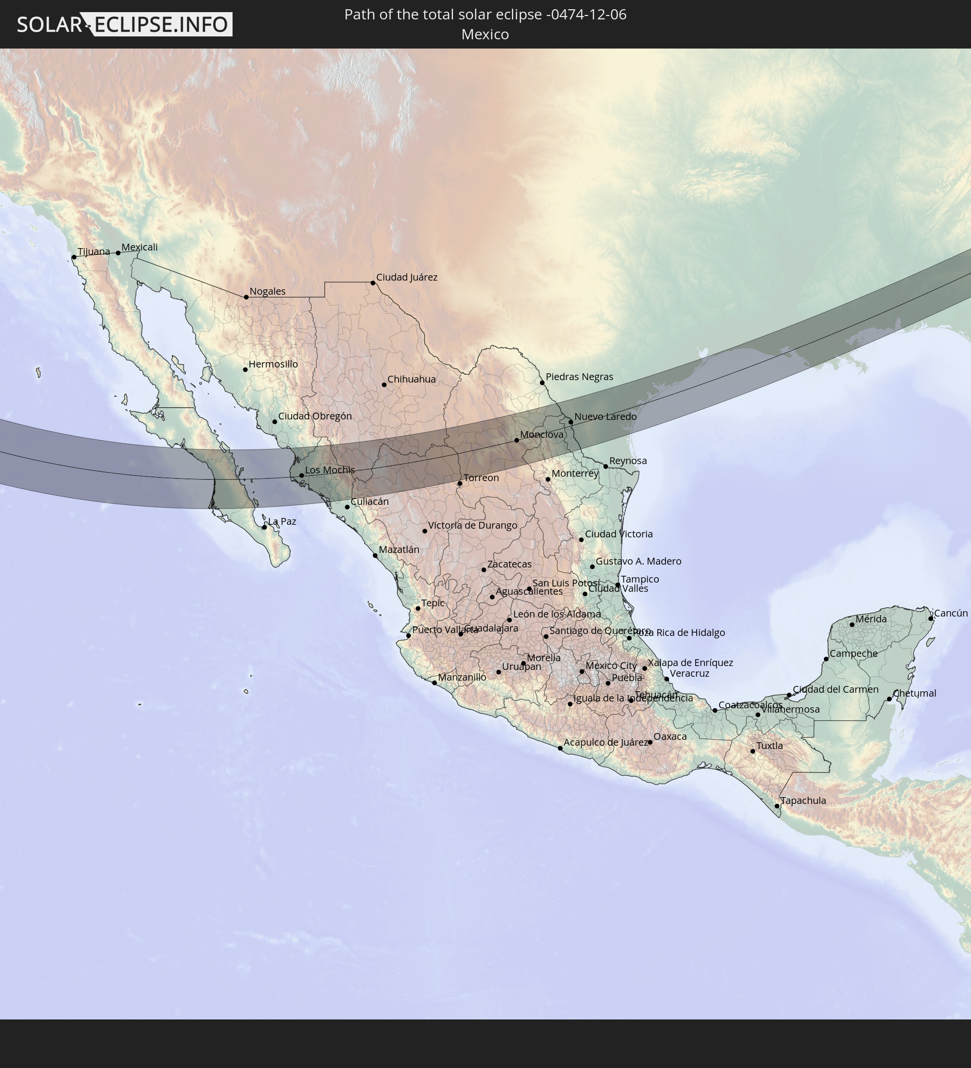 Mexiko
In den folgenden Ländern ist die Sonnenfinsternis partiell zu sehen


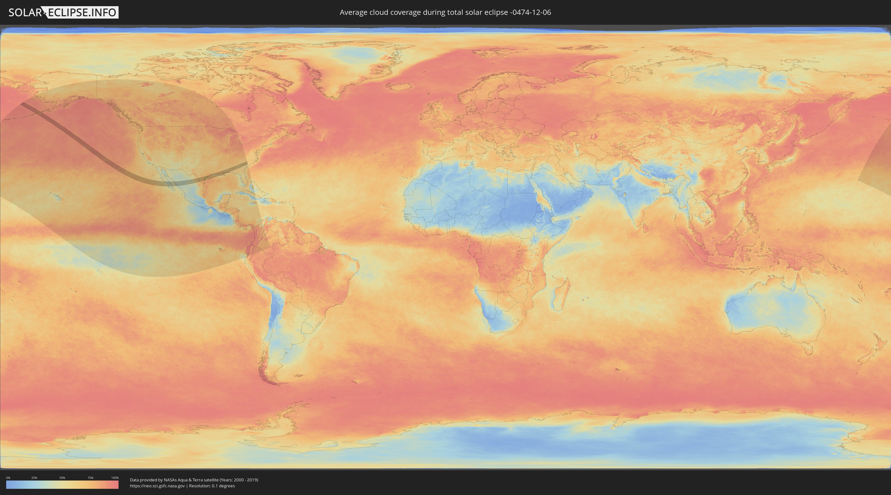
Wie wird das Wetter während der totalen Sonnenfinsternis am 06.12.-0474?
Wo ist der beste Ort, um die totale Sonnenfinsternis vom 06.12.-0474 zu beobachten?
Die folgenden Karten zeigen die durchschnittliche Bewölkung für den Tag, an dem die totale Sonnenfinsternis
stattfindet. Mit Hilfe der Karten lässt sich der Ort entlang des Finsternispfades eingrenzen,
der die besten Aussichen auf einen klaren wolkenfreien Himmel bietet.
Trotzdem muss man immer lokale Gegenenheiten beachten und sollte sich genau über das Wetter an seinem
gewählten Beobachtungsort informieren.
Die Daten stammen von den beiden NASA-Satelliten
AQUA und TERRA
und wurden über einen Zeitraum von 19 Jahren (2000 - 2019) gemittelt.

Detaillierte Länderkarten
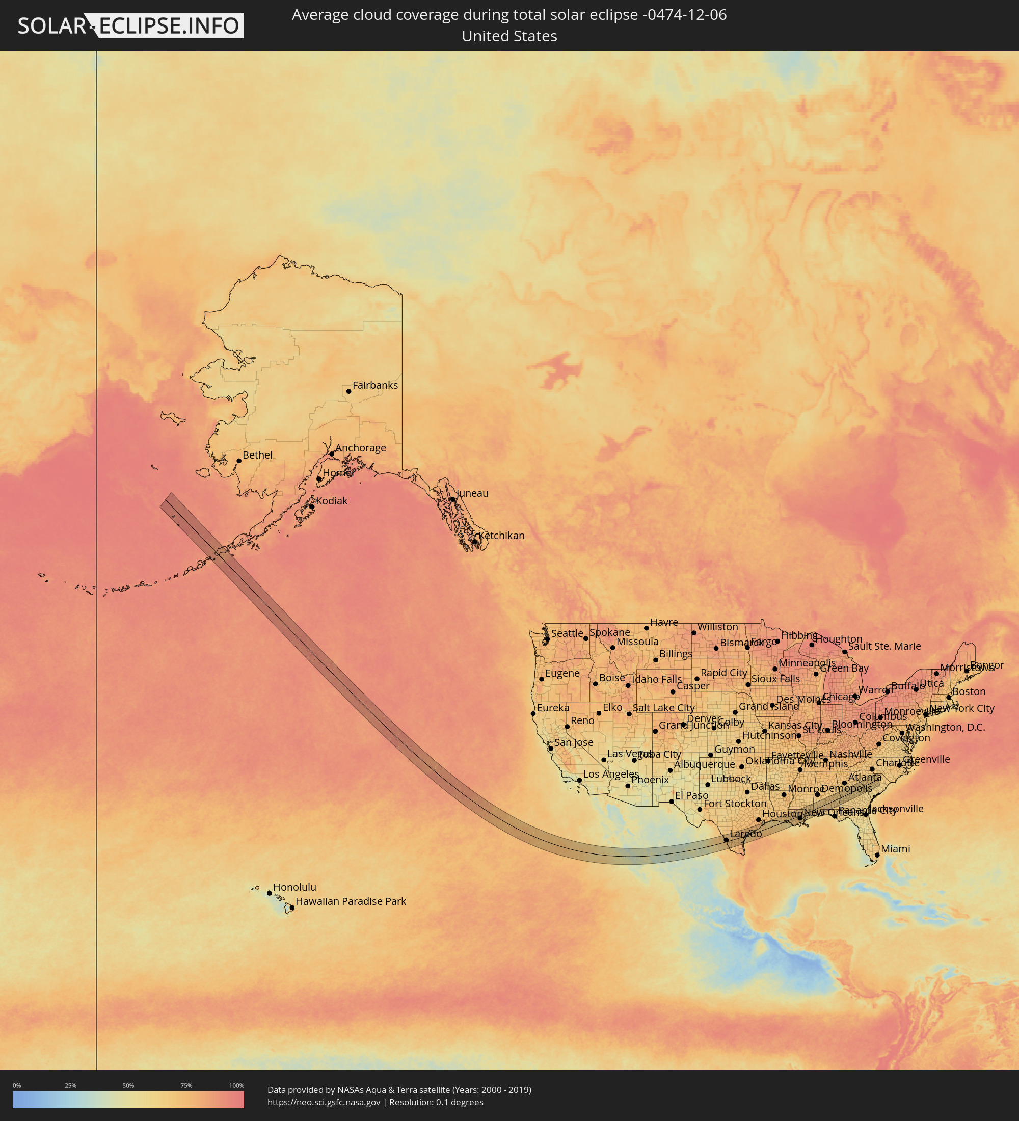 Vereinigte Staaten
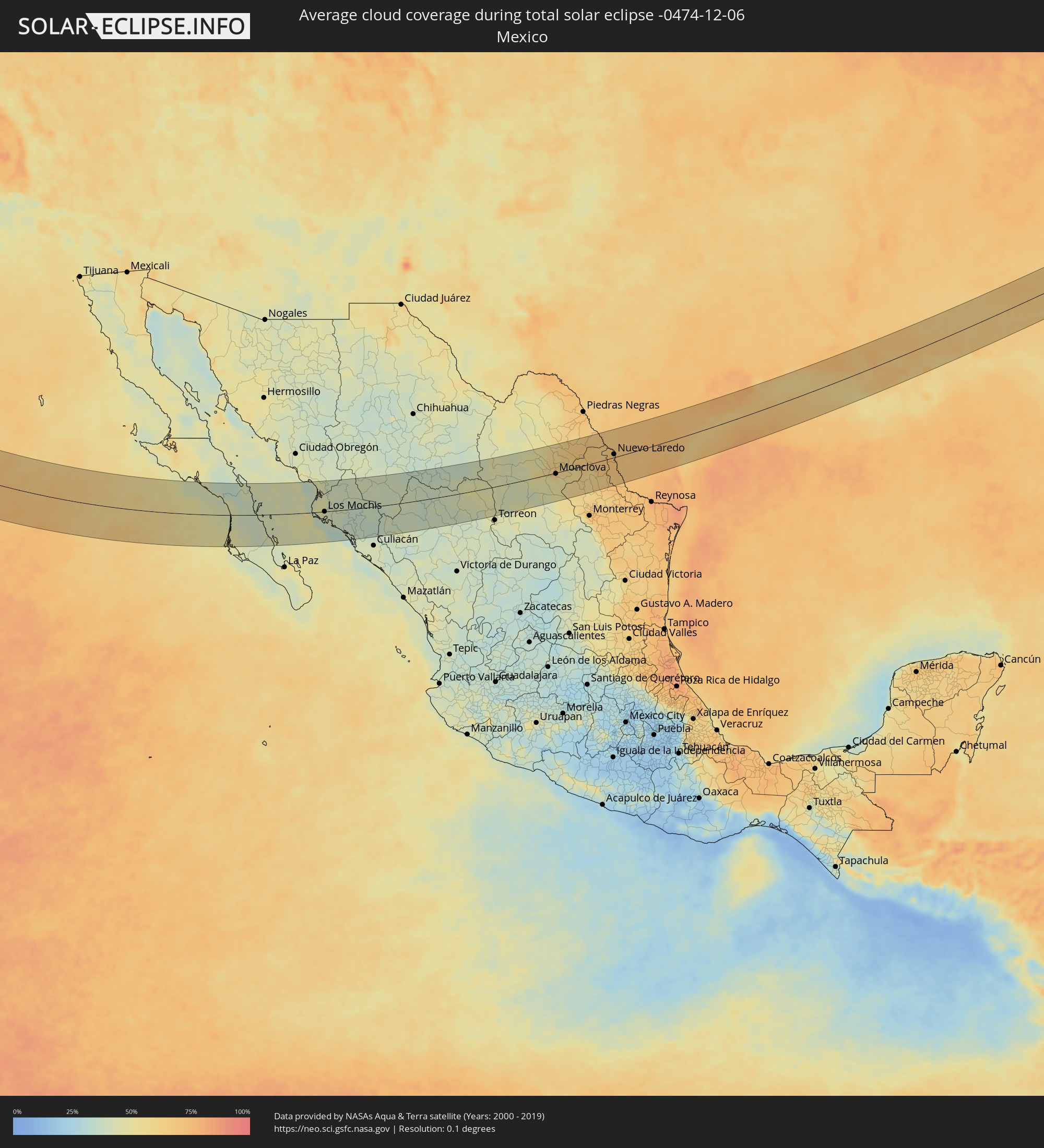 Mexiko
Orte im Finsternispfad
Die nachfolgene Tabelle zeigt Städte und Orte mit mehr als 5.000 Einwohnern, die sich im Finsternispfad befinden. Städte mit mehr als 100.000 Einwohnern sind dick gekennzeichnet. Mit einem Klick auf den Ort öffnet sich eine Detailkarte die die Lage des jeweiligen Ortes zusammen mit dem Verlauf der zentralen Finsternis präsentiert.
| Ort | Typ | Dauer der Verfinsterung | Ortszeit bei maximaler Verfinsterung | Entfernung zur Zentrallinie | Ø Bewölkung |
 Ciudad Insurgentes, Baja California Sur
|
total | - | 14:35:49 UTC-07:05 | 48 km | 43% |
|
Ciudad Constitución, Baja California Sur
|
total | - | 14:36:19 UTC-07:05 | 74 km | 45% |
|
Loreto, Baja California Sur
|
total | - | 14:35:52 UTC-07:05 | 35 km | 39% |
|
Higuera de Zaragoza, Sinaloa
|
total | - | 14:40:03 UTC-07:05 | 21 km | 47% |
|
Ahome, Sinaloa
|
total | - | 14:40:22 UTC-07:05 | 15 km | 48% |
|
Topolobampo, Sinaloa
|
total | - | 14:40:58 UTC-07:05 | 21 km | 36% |
|
San Miguel Zapotitlan, Sinaloa
|
total | - | 14:40:34 UTC-07:05 | 17 km | 47% |
|
Los Mochis, Sinaloa
|
total | - | 14:40:51 UTC-07:05 | 0 km | 45% |
|
Juan Jose Rios, Sinaloa
|
total | - | 14:41:14 UTC-07:05 | 6 km | 40% |
|
San Blas, Sinaloa
|
total | - | 14:40:59 UTC-07:05 | 29 km | 41% |
|
Adolfo Ruíz Cortínes, Sinaloa
|
total | - | 14:41:23 UTC-07:05 | 7 km | 40% |
|
Leyva Solano, Sinaloa
|
total | - | 14:41:42 UTC-07:05 | 18 km | 39% |
|
El Fuerte de Montes Claros, Sinaloa
|
total | - | 14:40:52 UTC-07:05 | 66 km | 41% |
|
Guasave, Sinaloa
|
total | - | 14:42:08 UTC-07:05 | 30 km | 40% |
|
Choix, Sinaloa
|
total | - | 14:41:05 UTC-07:05 | 95 km | 39% |
|
Guamúchil, Sinaloa
|
total | - | 14:43:01 UTC-07:05 | 46 km | 38% |
|
La Reforma, Sinaloa
|
total | - | 14:43:29 UTC-07:05 | 88 km | 38% |
|
Mocorito, Sinaloa
|
total | - | 14:43:17 UTC-07:05 | 45 km | 36% |
|
Santa Bárbara, Chihuahua
|
total | - | 14:45:37 UTC-07:05 | 74 km | 38% |
|
Hidalgo del Parral, Chihuahua
|
total | - | 14:45:45 UTC-07:05 | 85 km | 38% |
|
Santa María del Oro, Durango
|
total | - | 15:16:29 UTC-06:36 | 28 km | 42% |
|
Bermejillo, Durango
|
total | - | 15:19:32 UTC-06:36 | 66 km | 47% |
|
Poanas, Durango
|
total | - | 15:19:42 UTC-06:36 | 79 km | 46% |
|
Tlahualilo de Zaragoza, Durango
|
total | - | 15:19:35 UTC-06:36 | 46 km | 43% |
|
Concordia, Coahuila
|
total | - | 15:20:30 UTC-06:36 | 88 km | 43% |
|
San Buenaventura, Coahuila
|
total | - | 15:21:29 UTC-06:36 | 17 km | 64% |
|
Ciudad Frontera, Coahuila
|
total | - | 15:21:48 UTC-06:36 | 0 km | 57% |
|
Castaños, Coahuila
|
total | - | 15:22:00 UTC-06:36 | 16 km | 55% |
|
Monclova, Coahuila
|
total | - | 15:21:52 UTC-06:36 | 3 km | 56% |
|
Minas de Barroterán, Coahuila
|
total | - | 15:21:12 UTC-06:36 | 74 km | 60% |
|
Lampazos de Naranjo, Nuevo León
|
total | - | 15:23:07 UTC-06:36 | 13 km | 62% |
|
Sabinas Hidalgo, Nuevo León
|
total | - | 15:24:12 UTC-06:36 | 77 km | 62% |
|
Ciudad Anáhuac, Nuevo León
|
total | - | 15:23:25 UTC-06:36 | 1 km | 68% |
|
Anáhuac, Nuevo León
|
total | - | 15:23:25 UTC-06:36 | 1 km | 68% |
|
El Campanario y Oradel, Tamaulipas
|
total | - | 15:23:53 UTC-06:36 | 12 km | 72% |
|
Nuevo Laredo, Tamaulipas
|
total | - | 15:24:02 UTC-06:36 | 10 km | 72% |
 Laredo, Texas
|
total | - | 16:00:36 UTC-06:00 | 13 km | 72% |
|
Alice, Texas
|
total | - | 16:02:19 UTC-06:00 | 1 km | 73% |
|
Kingsville, Texas
|
total | - | 16:02:53 UTC-06:00 | 32 km | 72% |
|
Beeville, Texas
|
total | - | 16:01:58 UTC-06:00 | 58 km | 73% |
|
Robstown, Texas
|
total | - | 16:02:49 UTC-06:00 | 9 km | 70% |
|
Corpus Christi, Texas
|
total | - | 16:03:10 UTC-06:00 | 16 km | 71% |
|
Ingleside, Texas
|
total | - | 16:03:19 UTC-06:00 | 13 km | 69% |
|
Aransas Pass, Texas
|
total | - | 16:03:21 UTC-06:00 | 12 km | 66% |
|
Rockport, Texas
|
total | - | 16:03:21 UTC-06:00 | 3 km | 68% |
|
Victoria, Texas
|
total | - | 16:02:28 UTC-06:00 | 79 km | 72% |
|
Port Lavaca, Texas
|
total | - | 16:03:11 UTC-06:00 | 47 km | 72% |
|
Bay City, Texas
|
total | - | 16:03:34 UTC-06:00 | 65 km | 75% |
|
Lake Jackson, Texas
|
total | - | 16:04:10 UTC-06:00 | 54 km | 74% |
|
Angleton, Texas
|
total | - | 16:04:00 UTC-06:00 | 68 km | 75% |
|
La Marque, Texas
|
total | - | 16:04:19 UTC-06:00 | 74 km | 74% |
|
Galveston, Texas
|
total | - | 16:04:36 UTC-06:00 | 61 km | 67% |
|
Crowley, Louisiana
|
total | - | 16:06:12 UTC-06:00 | 73 km | 73% |
|
Abbeville, Louisiana
|
total | - | 16:06:45 UTC-06:00 | 40 km | 71% |
|
Scott, Louisiana
|
total | - | 16:06:28 UTC-06:00 | 66 km | 73% |
|
Lafayette, Louisiana
|
total | - | 16:06:34 UTC-06:00 | 62 km | 73% |
|
Youngsville, Louisiana
|
total | - | 16:06:45 UTC-06:00 | 48 km | 73% |
|
Broussard, Louisiana
|
total | - | 16:06:43 UTC-06:00 | 52 km | 73% |
|
Breaux Bridge, Louisiana
|
total | - | 16:06:38 UTC-06:00 | 63 km | 69% |
|
New Iberia, Louisiana
|
total | - | 16:07:03 UTC-06:00 | 32 km | 68% |
|
Morgan City, Louisiana
|
total | - | 16:08:03 UTC-06:00 | 22 km | 64% |
|
Zachary, Louisiana
|
total | - | 16:06:56 UTC-06:00 | 75 km | 72% |
|
Baton Rouge, Louisiana
|
total | - | 16:07:11 UTC-06:00 | 54 km | 75% |
|
Gardere, Louisiana
|
total | - | 16:07:19 UTC-06:00 | 43 km | 72% |
|
Merrydale, Louisiana
|
total | - | 16:07:10 UTC-06:00 | 58 km | 75% |
|
Oak Hills Place, Louisiana
|
total | - | 16:07:21 UTC-06:00 | 42 km | 73% |
|
Central, Louisiana
|
total | - | 16:07:10 UTC-06:00 | 60 km | 71% |
|
Prairieville, Louisiana
|
total | - | 16:07:33 UTC-06:00 | 32 km | 73% |
|
Denham Springs, Louisiana
|
total | - | 16:07:20 UTC-06:00 | 51 km | 72% |
|
Gonzales, Louisiana
|
total | - | 16:07:40 UTC-06:00 | 24 km | 70% |
|
Thibodaux, Louisiana
|
total | - | 16:08:19 UTC-06:00 | 26 km | 71% |
|
Houma, Louisiana
|
total | - | 16:08:40 UTC-06:00 | 50 km | 71% |
|
Raceland, Louisiana
|
total | - | 16:08:37 UTC-06:00 | 41 km | 70% |
|
Reserve, Louisiana
|
total | - | 16:08:16 UTC-06:00 | 9 km | 71% |
|
Laplace, Louisiana
|
total | - | 16:08:19 UTC-06:00 | 10 km | 71% |
|
Hammond, Louisiana
|
total | - | 16:07:48 UTC-06:00 | 34 km | 68% |
|
Saint Rose, Louisiana
|
total | - | 16:08:37 UTC-06:00 | 28 km | 68% |
|
Kenner, Louisiana
|
total | - | 16:08:38 UTC-06:00 | 26 km | 73% |
|
Waggaman, Louisiana
|
total | - | 16:08:46 UTC-06:00 | 35 km | 69% |
|
Harahan, Louisiana
|
total | - | 16:08:45 UTC-06:00 | 33 km | 69% |
|
Westwego, Louisiana
|
total | - | 16:08:51 UTC-06:00 | 39 km | 71% |
|
Covington, Louisiana
|
total | - | 16:08:11 UTC-06:00 | 18 km | 67% |
|
New Orleans, Louisiana
|
total | - | 16:08:51 UTC-06:00 | 36 km | 73% |
|
Mandeville, Louisiana
|
total | - | 16:08:22 UTC-06:00 | 5 km | 66% |
|
Timberlane, Louisiana
|
total | - | 16:08:59 UTC-06:00 | 46 km | 71% |
|
Lacombe, Louisiana
|
total | - | 16:08:32 UTC-06:00 | 4 km | 67% |
|
Bogalusa, Louisiana
|
total | - | 16:08:02 UTC-06:00 | 41 km | 70% |
|
Slidell, Louisiana
|
total | - | 16:08:44 UTC-06:00 | 14 km | 69% |
|
Carriere, Mississippi
|
total | - | 16:08:26 UTC-06:00 | 16 km | 71% |
|
Diamondhead, Mississippi
|
total | - | 16:08:58 UTC-06:00 | 18 km | 63% |
|
Bay Saint Louis, Mississippi
|
total | - | 16:09:07 UTC-06:00 | 28 km | 62% |
|
Hattiesburg, Mississippi
|
total | - | 16:07:53 UTC-06:00 | 75 km | 66% |
|
Petal, Mississippi
|
total | - | 16:07:53 UTC-06:00 | 76 km | 66% |
|
West Gulfport, Mississippi
|
total | - | 16:09:13 UTC-06:00 | 27 km | 66% |
|
D'Iberville, Mississippi
|
total | - | 16:09:22 UTC-06:00 | 32 km | 62% |
|
Biloxi, Mississippi
|
total | - | 16:09:24 UTC-06:00 | 35 km | 62% |
|
Pascagoula, Mississippi
|
total | - | 16:09:44 UTC-06:00 | 51 km | 65% |
|
Tillmans Corner, Alabama
|
total | - | 16:09:48 UTC-06:00 | 43 km | 70% |
|
Mobile, Alabama
|
total | - | 16:09:47 UTC-06:00 | 37 km | 65% |
|
Daphne, Alabama
|
total | - | 16:10:01 UTC-06:00 | 52 km | 65% |
|
Bay Minette, Alabama
|
total | - | 16:09:47 UTC-06:00 | 28 km | 64% |
|
Atmore, Alabama
|
total | - | 16:09:50 UTC-06:00 | 24 km | 66% |
|
Cantonment, Florida
|
total | - | 16:10:29 UTC-06:00 | 73 km | 68% |
|
Greenville, Alabama
|
total | - | 16:09:33 UTC-06:00 | 23 km | 66% |
|
Andalusia, Alabama
|
total | - | 16:10:19 UTC-06:00 | 35 km | 66% |
|
Montgomery, Alabama
|
total | - | 16:09:07 UTC-06:00 | 65 km | 69% |
|
Troy, Alabama
|
total | - | 16:10:05 UTC-06:00 | 4 km | 69% |
|
Enterprise, Alabama
|
total | - | 16:10:48 UTC-06:00 | 59 km | 68% |
|
Tuskegee, Alabama
|
total | - | 16:09:32 UTC-06:00 | 47 km | 67% |
|
Ozark, Alabama
|
total | - | 16:10:47 UTC-06:00 | 53 km | 64% |
|
Auburn, Alabama
|
total | - | 16:09:27 UTC-06:00 | 57 km | 68% |
|
Valley, Alabama
|
total | - | 16:09:24 UTC-06:00 | 66 km | 65% |
|
Eufaula, Alabama
|
total | - | 16:10:37 UTC-06:00 | 29 km | 61% |
|
Columbus, Georgia
|
total | - | 17:10:00 UTC-05:00 | 22 km | 66% |
|
Cusseta, Georgia
|
total | - | 17:10:22 UTC-05:00 | 2 km | 61% |
|
Thomaston, Georgia
|
total | - | 17:09:56 UTC-05:00 | 39 km | 62% |
|
Americus, Georgia
|
total | - | 17:11:03 UTC-05:00 | 47 km | 63% |
|
Fort Valley, Georgia
|
total | - | 17:10:40 UTC-05:00 | 13 km | 63% |
|
Perry, Georgia
|
total | - | 17:10:54 UTC-05:00 | 29 km | 62% |
|
Macon, Georgia
|
total | - | 17:10:29 UTC-05:00 | 6 km | 60% |
|
Warner Robins, Georgia
|
total | - | 17:10:47 UTC-05:00 | 17 km | 63% |
|
Milledgeville, Georgia
|
total | - | 17:10:27 UTC-05:00 | 13 km | 61% |
|
Dublin, Georgia
|
total | - | 17:11:21 UTC-05:00 | 54 km | 64% |
|
Evans, Georgia
|
total | - | 17:10:35 UTC-05:00 | 14 km | 65% |
|
Augusta, Georgia
|
total | - | 17:10:45 UTC-05:00 | 1 km | 63% |
|
Aiken, South Carolina
|
total | - | 17:10:48 UTC-05:00 | 1 km | 63% |
|
Newberry, South Carolina
|
total | - | 17:09:56 UTC-05:00 | 66 km | 65% |
|
Red Bank, South Carolina
|
total | - | 17:10:36 UTC-05:00 | 16 km | 66% |
|
Lexington, South Carolina
|
total | - | 17:10:33 UTC-05:00 | 21 km | 66% |
|
Oak Grove, South Carolina
|
total | - | 17:10:36 UTC-05:00 | 17 km | 66% |
|
Columbia, South Carolina
|
total | - | 17:10:38 UTC-05:00 | 14 km | 65% |
|
Forest Acres, South Carolina
|
total | - | 17:10:38 UTC-05:00 | 14 km | 65% |
|
Oak Grove, South Carolina
|
total | - | 17:10:58 UTC-05:00 | 10 km | 63% |
|
Woodfield, South Carolina
|
total | - | 17:10:37 UTC-05:00 | 16 km | 64% |
|
Orangeburg, South Carolina
|
total | - | 17:11:24 UTC-05:00 | 44 km | 63% |
|
Sumter, South Carolina
|
total | - | 17:11:08 UTC-05:00 | 22 km | 64% |