Totale Sonnenfinsternis vom 18.05.-0621
| Wochentag: | Sonntag |
| Maximale Dauer der Verfinsterung: | 05m34s |
| Maximale Breite des Finsternispfades: | 209 km |
| Saroszyklus: | 47 |
| Bedeckungsgrad: | 100% |
| Magnitude: | 1.0613 |
| Gamma: | -0.2765 |
Wo kann man die Sonnenfinsternis vom 18.05.-0621 sehen?
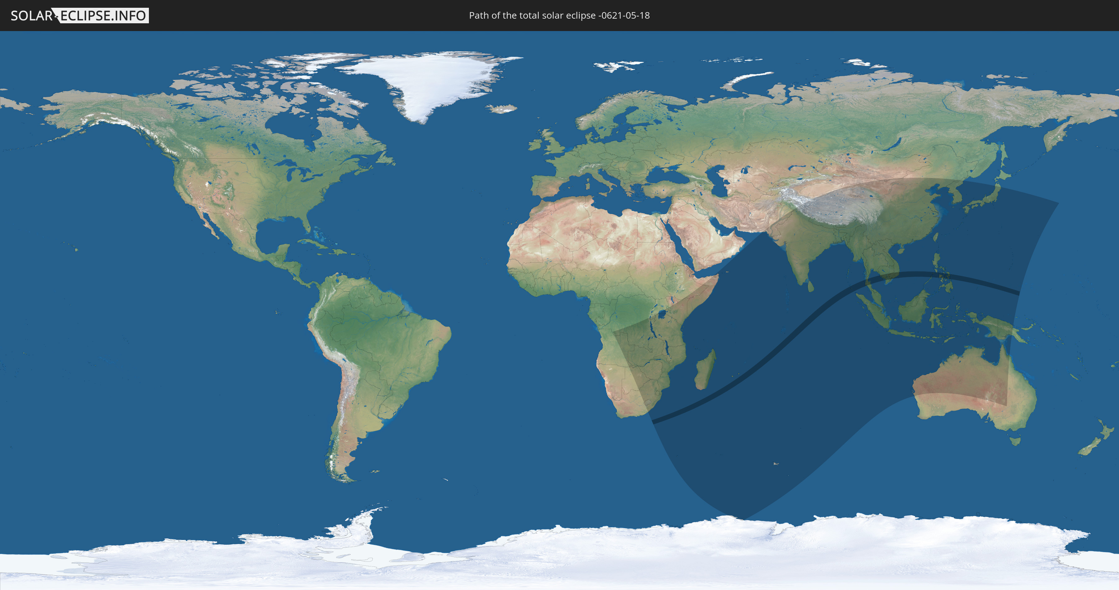
Die Sonnenfinsternis am 18.05.-0621 kann man in 63 Ländern als partielle Sonnenfinsternis beobachten.
Der Finsternispfad verläuft durch 7 Länder. Nur in diesen Ländern ist sie als totale Sonnenfinsternis zu sehen.
In den folgenden Ländern ist die Sonnenfinsternis total zu sehen
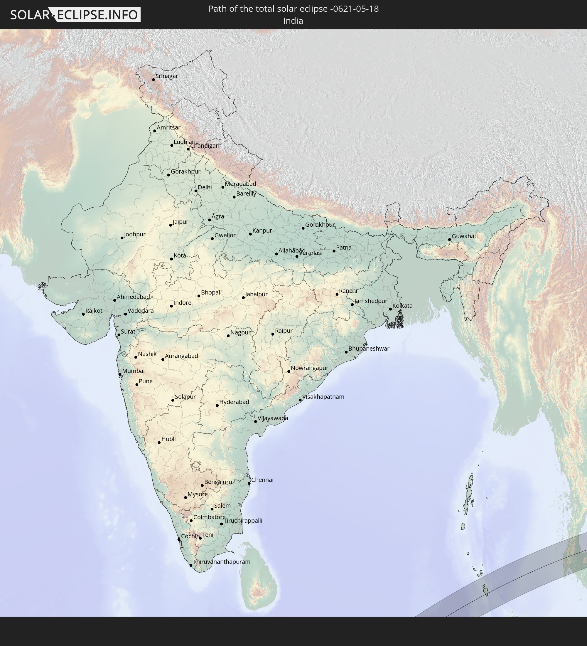 Indien
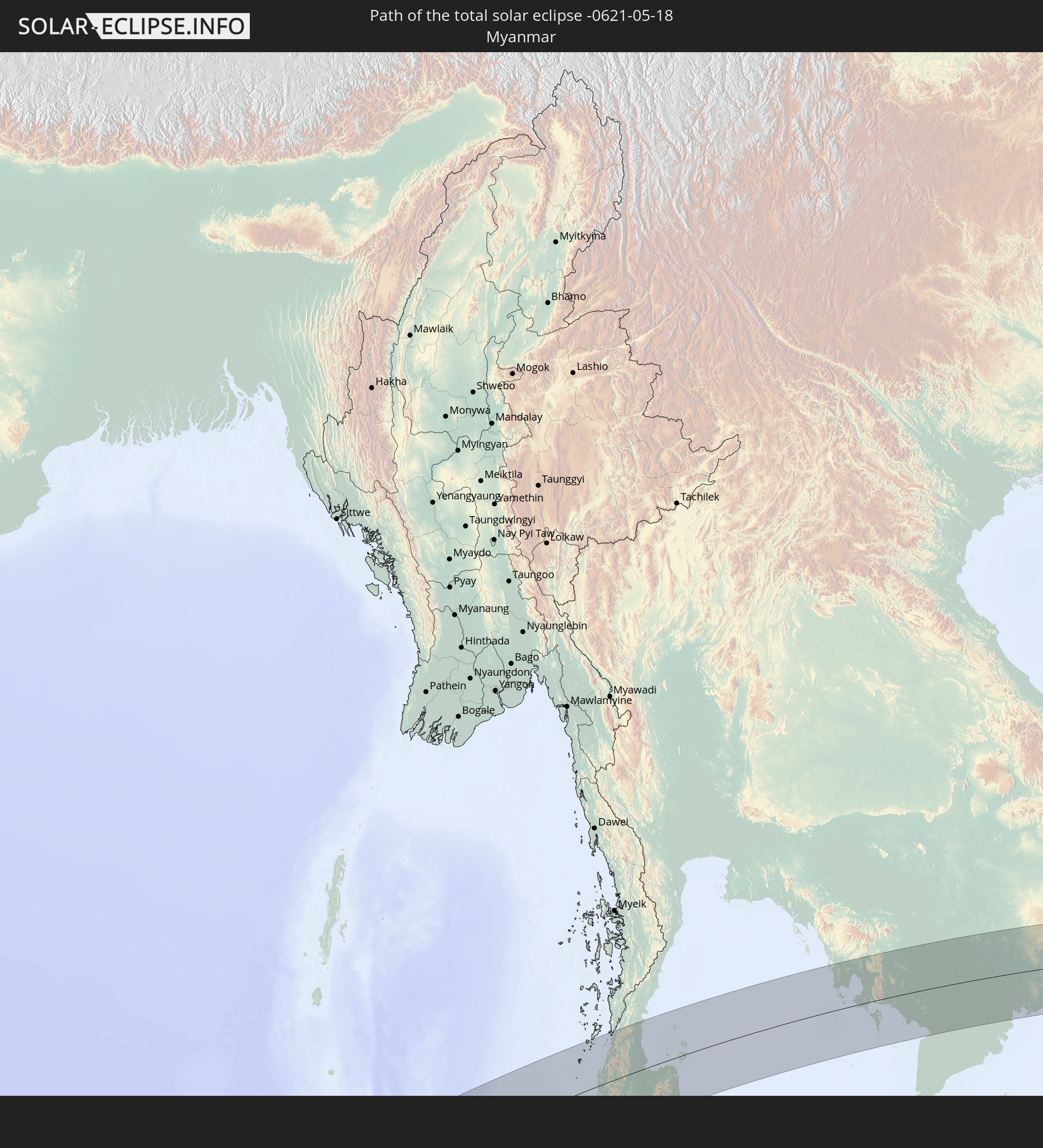 Myanmar
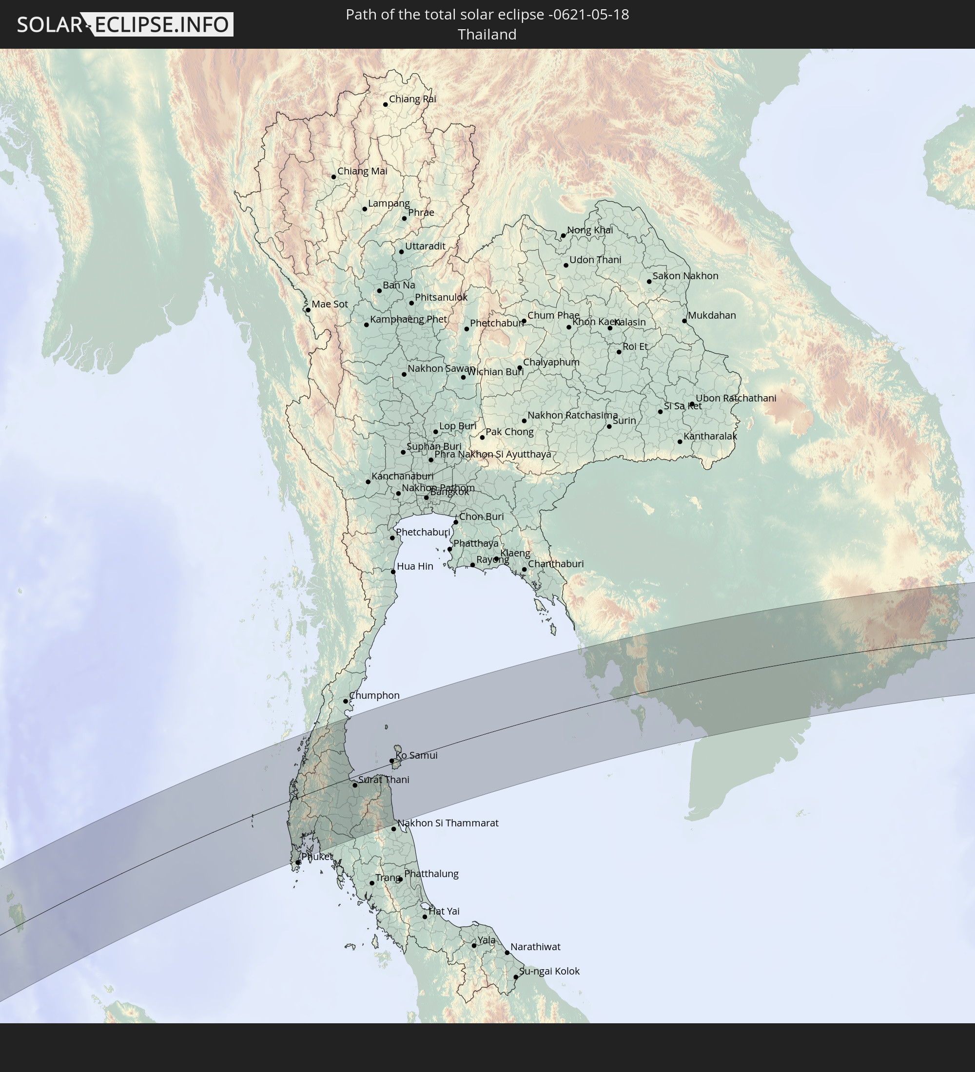 Thailand
 Vietnam
 Kambodscha
 Philippinen
 Föderierte Staaten von Mikronesien
In den folgenden Ländern ist die Sonnenfinsternis partiell zu sehen
 Antarktika
 Angola
 Namibia
 Demokratische Republik Kongo
 Südafrika
 Botswana
 Sambia
 Simbabwe
 Lesotho
 Ruanda
 Burundi
 Tansania
 Uganda
 Mosambik
 Swasiland
 Malawi
 Äthiopien
 Kenia
Kenia
 Französische Süd- und Antarktisgebiete
 Somalia
 Jemen
Jemen
 Madagaskar
 Komoren
 Mayotte
 Seychellen
 Réunion
 Mauritius
 Pakistan
 Indien
 Britisches Territorium im Indischen Ozean
 Heard und McDonaldinseln
 Malediven
 Volksrepublik China
 Sri Lanka
 Nepal
Nepal
 Mongolei
 Bangladesch
 Bhutan
 Myanmar
 Indonesien
 Kokosinseln
 Thailand
 Malaysia
 Laos
Laos
 Vietnam
 Kambodscha
 Singapur
 Weihnachtsinsel
 Australien
 Macau
Macau
 Hongkong
 Brunei
 Taiwan
 Philippinen
 Japan
Japan
 Osttimor
 Nordkorea
 Südkorea
 Palau
Palau
 Föderierte Staaten von Mikronesien
 Papua-Neuguinea
 Guam
Guam
 Nördliche Marianen
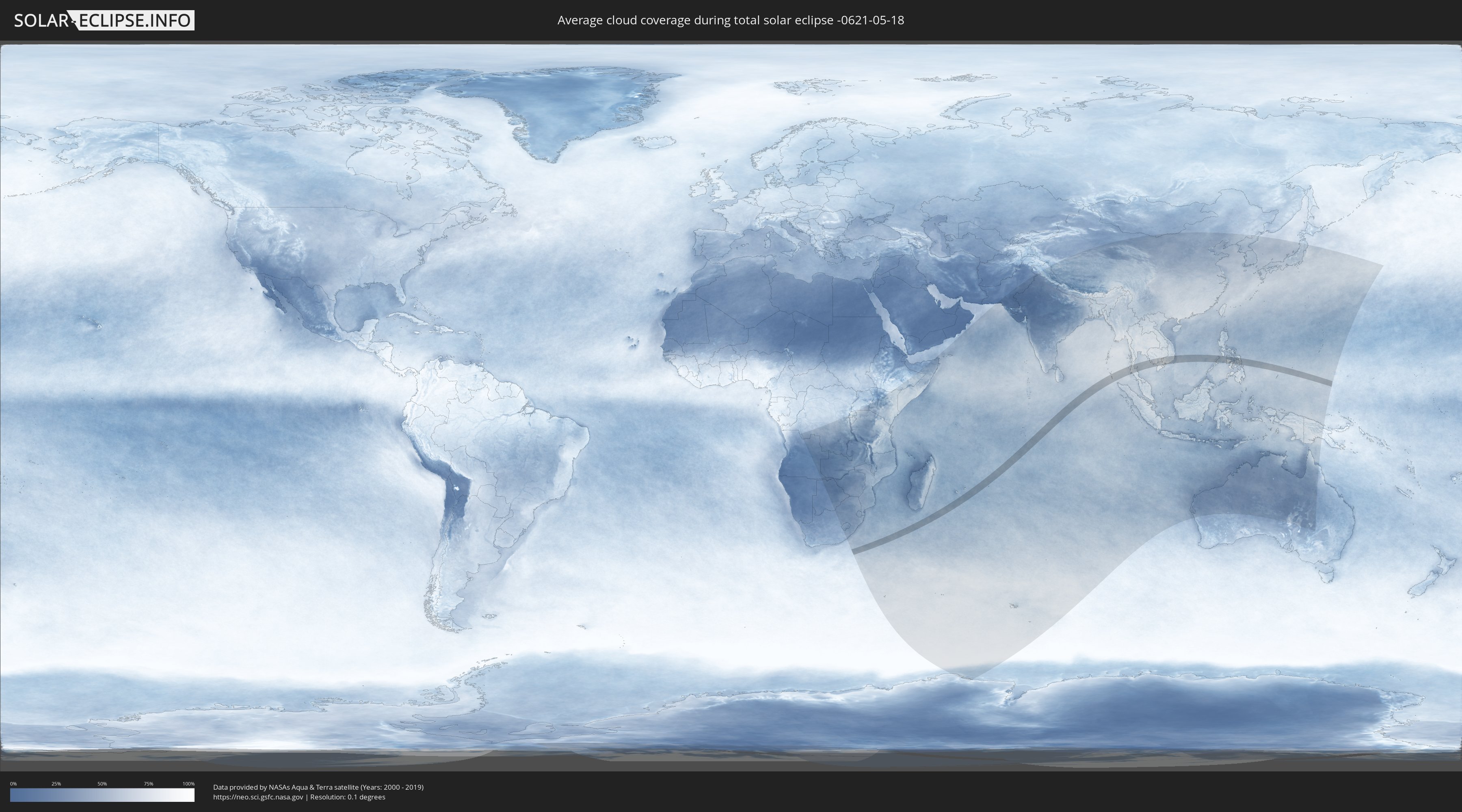
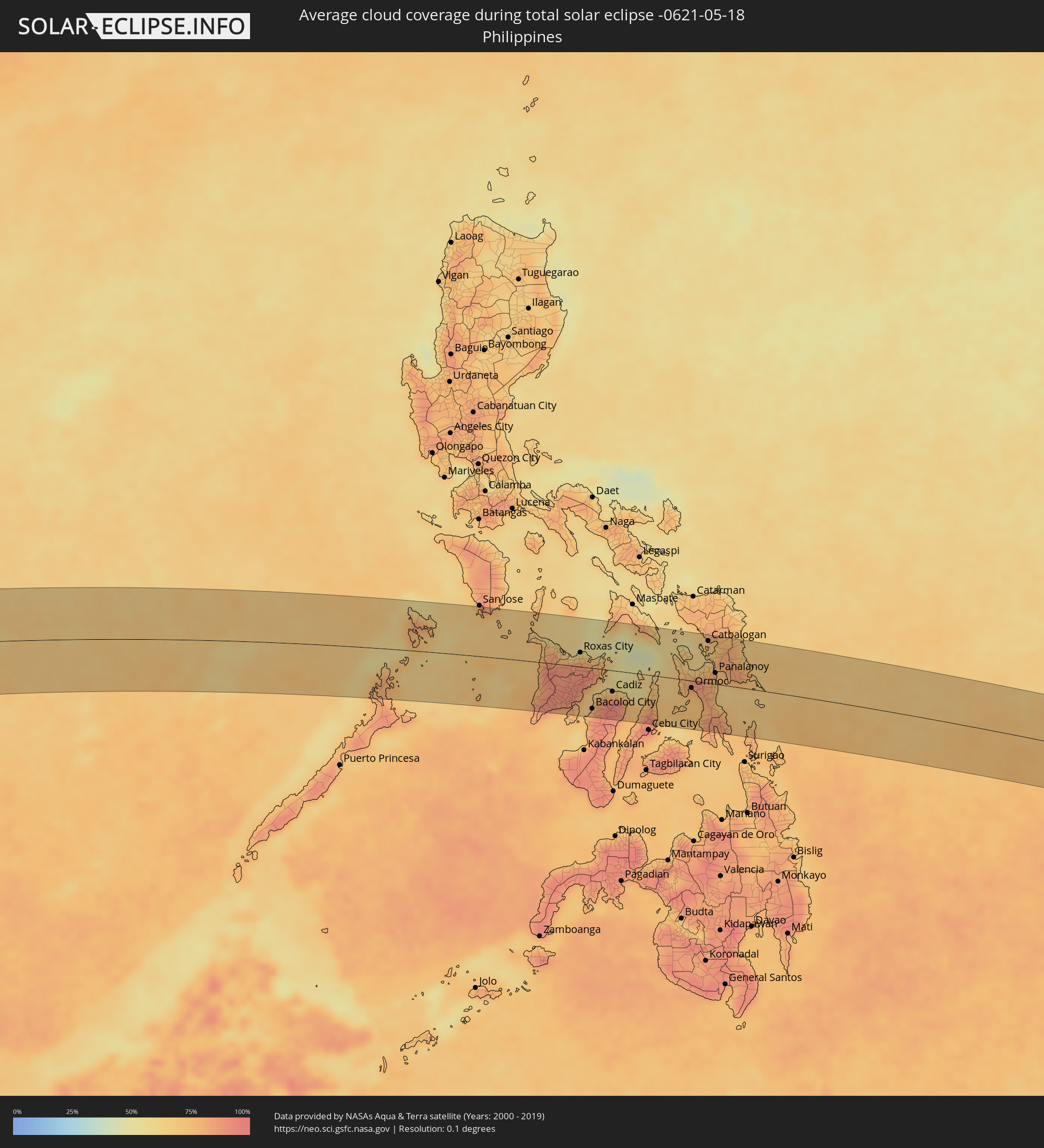
Wie wird das Wetter während der totalen Sonnenfinsternis am 18.05.-0621?
Wo ist der beste Ort, um die totale Sonnenfinsternis vom 18.05.-0621 zu beobachten?
Die folgenden Karten zeigen die durchschnittliche Bewölkung für den Tag, an dem die totale Sonnenfinsternis
stattfindet. Mit Hilfe der Karten lässt sich der Ort entlang des Finsternispfades eingrenzen,
der die besten Aussichen auf einen klaren wolkenfreien Himmel bietet.
Trotzdem muss man immer lokale Gegenenheiten beachten und sollte sich genau über das Wetter an seinem
gewählten Beobachtungsort informieren.
Die Daten stammen von den beiden NASA-Satelliten
AQUA und TERRA
und wurden über einen Zeitraum von 19 Jahren (2000 - 2019) gemittelt.

Detaillierte Länderkarten
 Indien
 Myanmar
 Thailand
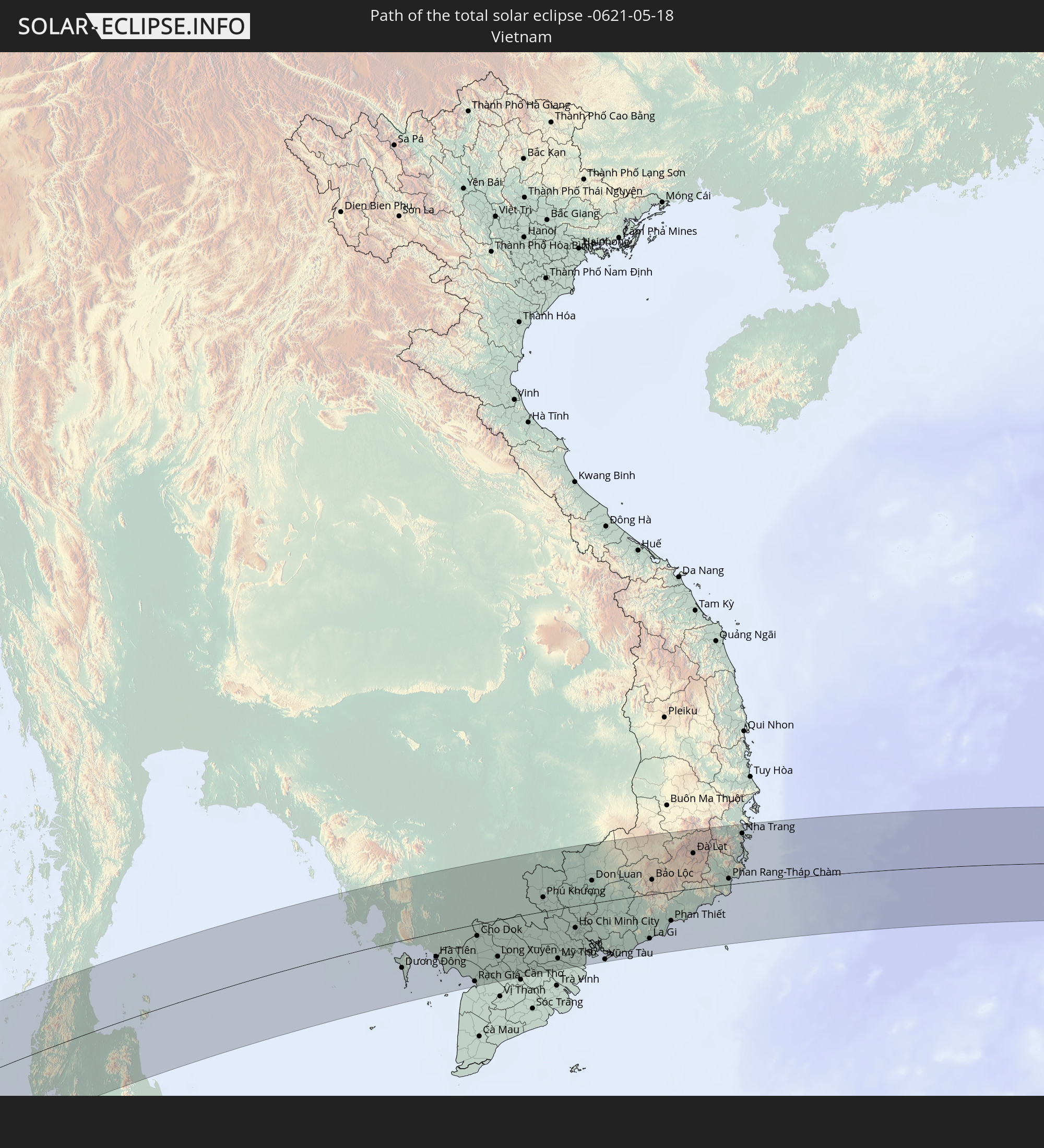
 Vietnam
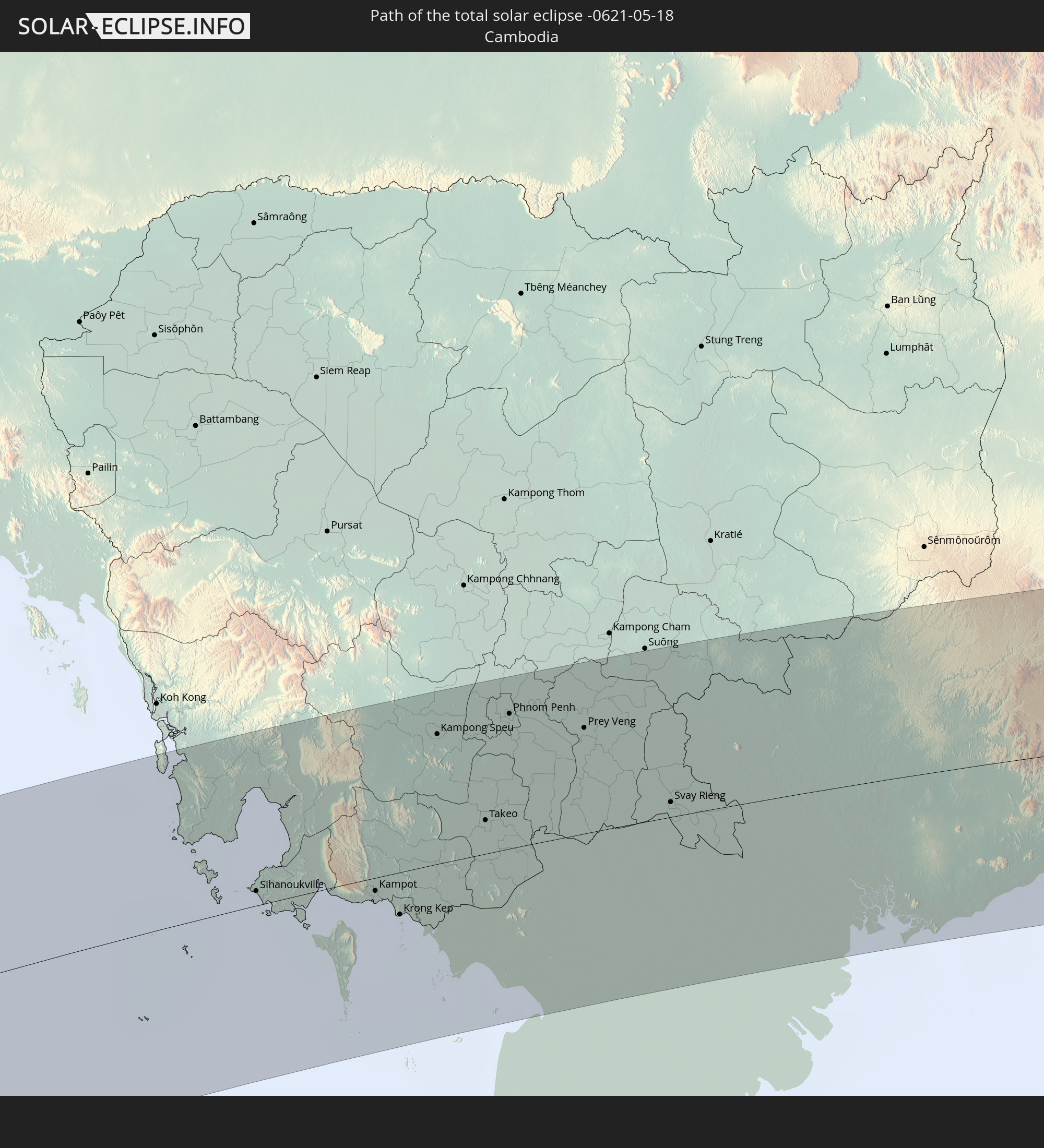
 Kambodscha
 Philippinen
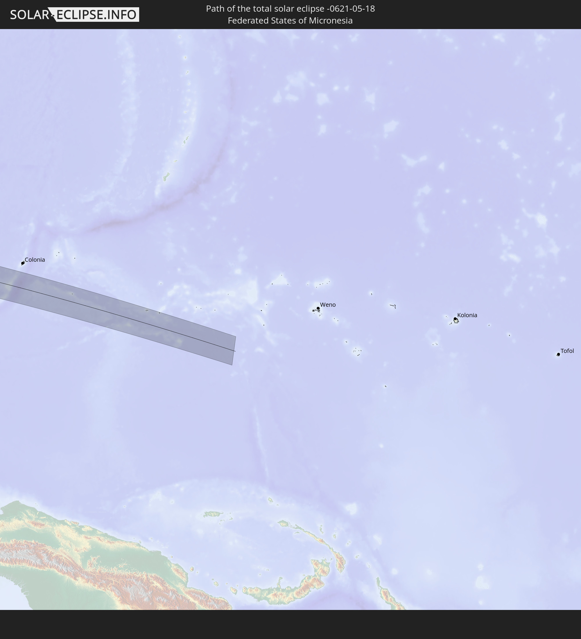
 Föderierte Staaten von Mikronesien
Orte im Finsternispfad
Die nachfolgene Tabelle zeigt Städte und Orte mit mehr als 5.000 Einwohnern, die sich im Finsternispfad befinden. Städte mit mehr als 100.000 Einwohnern sind dick gekennzeichnet. Mit einem Klick auf den Ort öffnet sich eine Detailkarte die die Lage des jeweiligen Ortes zusammen mit dem Verlauf der zentralen Finsternis präsentiert.
| Ort | Typ | Dauer der Verfinsterung | Ortszeit bei maximaler Verfinsterung | Entfernung zur Zentrallinie | Ø Bewölkung |
|
Phang Nga, Phangnga
|
total | - | 13:46:15 UTC+06:42 | 57 km | 91% |
|
Ranong, Ranong
|
total | - | 13:48:28 UTC+06:42 | 96 km | 91% |
|
Ao Luek, Krabi
|
total | - | 13:46:38 UTC+06:42 | 73 km | 84% |
|
Ban Nam Yuen, Chumphon
|
total | - | 13:48:55 UTC+06:42 | 78 km | 90% |
|
Chai Buri, Surat Thani
|
total | - | 13:47:38 UTC+06:42 | 78 km | 88% |
|
Lang Suan, Chumphon
|
total | - | 13:49:32 UTC+06:42 | 78 km | 88% |
|
Chaiya, Surat Thani
|
total | - | 13:49:07 UTC+06:42 | 14 km | 87% |
|
Phunphin, Surat Thani
|
total | - | 13:48:51 UTC+06:42 | 16 km | 90% |
|
Surat Thani, Surat Thani
|
total | - | 13:49:08 UTC+06:42 | 16 km | 87% |
|
Ban Na San, Surat Thani
|
total | - | 13:48:47 UTC+06:42 | 53 km | 87% |
|
Wiang Sa, Surat Thani
|
total | - | 13:48:35 UTC+06:42 | 70 km | 87% |
|
Tham Phannara, Nakhon Si Thammarat
|
total | - | 13:48:22 UTC+06:42 | 94 km | 89% |
|
Chawang, Nakhon Si Thammarat
|
total | - | 13:48:39 UTC+06:42 | 98 km | 87% |
|
Don Sak, Surat Thani
|
total | - | 13:50:15 UTC+06:42 | 11 km | 85% |
|
Ko Samui, Surat Thani
|
total | - | 13:51:07 UTC+06:42 | 3 km | 75% |
|
Ko Pha Ngan, Nakhon Si Thammarat
|
total | - | 13:51:36 UTC+06:42 | 24 km | 79% |
|
Sihanoukville, Preah Sihanouk
|
total | - | 14:00:49 UTC+06:42 | 8 km | 85% |
|
Dương Đông, Kiến Giang
|
total | - | 14:26:00 UTC+07:06 | 45 km | 85% |
|
Kampot, Kampot
|
total | - | 14:02:18 UTC+06:42 | 8 km | 83% |
|
Krong Kep, Kep
|
total | - | 14:02:29 UTC+06:42 | 25 km | 82% |
|
Hà Tiên, Kiến Giang
|
total | - | 14:27:22 UTC+07:06 | 40 km | 85% |
|
Kampong Speu, Kampong Speu
|
total | - | 14:03:53 UTC+06:42 | 76 km | 94% |
|
Phumĭ Véal Srê, Takeo
|
total | - | 14:04:00 UTC+06:42 | 19 km | 96% |
|
Takeo, Takeo
|
total | - | 14:04:01 UTC+06:42 | 20 km | 96% |
|
Phnom Penh, Phnom Penh
|
total | - | 14:04:51 UTC+06:42 | 79 km | 91% |
|
Ta Khmau, Kandal
|
total | - | 14:04:51 UTC+06:42 | 70 km | 83% |
|
Rạch Giá, Kiến Giang
|
total | - | 14:28:20 UTC+07:06 | 94 km | 92% |
|
Cho Dok, An Giang
|
total | - | 14:29:05 UTC+07:06 | 19 km | 90% |
|
Prey Veng, Prey Veng
|
total | - | 14:05:41 UTC+06:42 | 62 km | 93% |
|
Long Xuyên, An Giang
|
total | - | 14:29:29 UTC+07:06 | 60 km | 87% |
|
Cao Lãnh, Đồng Tháp
|
total | - | 14:30:00 UTC+07:06 | 57 km | 90% |
|
Sadek, Đồng Tháp
|
total | - | 14:30:06 UTC+07:06 | 78 km | 89% |
|
Svay Rieng, Svay Rieng
|
total | - | 14:06:21 UTC+06:42 | 9 km | 94% |
|
Vĩnh Long, Vĩnh Long
|
total | - | 14:30:33 UTC+07:06 | 86 km | 87% |
|
Tây Ninh, Tây Ninh
|
total | - | 14:31:47 UTC+07:06 | 27 km | 97% |
|
Phú Khương, Tây Ninh
|
total | - | 14:31:50 UTC+07:06 | 24 km | 97% |
|
Ấp Tân Ngãi, Bến Tre
|
total | - | 14:31:13 UTC+07:06 | 94 km | 90% |
|
Mỹ Tho, Tiền Giang
|
total | - | 14:31:30 UTC+07:06 | 82 km | 93% |
|
Bến Tre, Bến Tre
|
total | - | 14:31:25 UTC+07:06 | 95 km | 90% |
|
Tân An, Long An
|
total | - | 14:31:46 UTC+07:06 | 64 km | 96% |
|
Củ Chi, Ho Chi Minh City
|
total | - | 14:32:20 UTC+07:06 | 17 km | 96% |
|
Bình Long, Bình Phước
|
total | - | 14:33:10 UTC+07:06 | 55 km | 93% |
|
Ho Chi Minh City, Ho Chi Minh City
|
total | - | 14:32:30 UTC+07:06 | 36 km | 96% |
|
Thủ Dầu Một, Bình Dương
|
total | - | 14:32:41 UTC+07:06 | 19 km | 95% |
|
Cần Giuộc, Long An
|
total | - | 14:32:24 UTC+07:06 | 60 km | 95% |
|
Biên Hòa, Đồng Nai
|
total | - | 14:33:01 UTC+07:06 | 26 km | 93% |
|
Don Luan, Bình Phước
|
total | - | 14:33:39 UTC+07:06 | 38 km | 93% |
|
Cần Giờ, Ho Chi Minh City
|
total | - | 14:32:50 UTC+07:06 | 87 km | 72% |
|
Vũng Tàu, Bà Rịa-Vũng Tàu
|
total | - | 14:33:03 UTC+07:06 | 97 km | 71% |
|
Thành Phố Bà Rịa, Bà Rịa-Vũng Tàu
|
total | - | 14:33:22 UTC+07:06 | 82 km | 88% |
|
Gia Nghĩa, Ðắk Nông
|
total | - | 14:35:43 UTC+07:06 | 76 km | 85% |
|
La Gi, Bình Thuận
|
total | - | 14:34:47 UTC+07:06 | 73 km | 84% |
|
Bảo Lộc, Lâm Đồng
|
total | - | 14:35:35 UTC+07:06 | 24 km | 84% |
|
Phan Thiết, Bình Thuận
|
total | - | 14:35:41 UTC+07:06 | 49 km | 79% |
|
Đinh Văn, Lâm Đồng
|
total | - | 14:36:40 UTC+07:06 | 44 km | 80% |
|
Ðà Lạt, Lâm Đồng
|
total | - | 14:37:12 UTC+07:06 | 59 km | 81% |
|
Phan Rang-Tháp Chàm, Ninh Thuận
|
total | - | 14:38:00 UTC+07:06 | 10 km | 83% |
|
Cam Ranh, Khánh Hòa
|
total | - | 14:38:36 UTC+07:06 | 47 km | 73% |
|
Nha Trang, Khánh Hòa
|
total | - | 14:38:55 UTC+07:06 | 82 km | 72% |
|
El Nido, Mimaropa
|
total | - | 15:48:54 UTC+08:00 | 52 km | 80% |
|
Coron, Mimaropa
|
total | - | 15:50:20 UTC+08:00 | 45 km | 72% |
|
Cuyo, Mimaropa
|
total | - | 15:50:57 UTC+08:00 | 75 km | 74% |
|
Caminauit, Mimaropa
|
total | - | 15:51:36 UTC+08:00 | 90 km | 73% |
|
Pandan, Western Visayas
|
total | - | 15:52:41 UTC+08:00 | 35 km | 73% |
|
Miagao, Western Visayas
|
total | - | 15:52:27 UTC+08:00 | 85 km | 73% |
|
Kalibo (poblacion), Western Visayas
|
total | - | 15:52:59 UTC+08:00 | 34 km | 68% |
|
Tigbauan, Western Visayas
|
total | - | 15:52:38 UTC+08:00 | 80 km | 75% |
|
Alimodian, Western Visayas
|
total | - | 15:52:45 UTC+08:00 | 63 km | 87% |
|
Janiuay, Western Visayas
|
total | - | 15:52:54 UTC+08:00 | 48 km | 91% |
|
Iloilo, Western Visayas
|
total | - | 15:52:52 UTC+08:00 | 75 km | 77% |
|
Passi, Western Visayas
|
total | - | 15:53:07 UTC+08:00 | 29 km | 90% |
|
Dao, Western Visayas
|
total | - | 15:53:16 UTC+08:00 | 4 km | 90% |
|
Barotac Nuevo, Western Visayas
|
total | - | 15:53:07 UTC+08:00 | 51 km | 81% |
|
Roxas City, Western Visayas
|
total | - | 15:53:25 UTC+08:00 | 26 km | 74% |
|
Barotac Viejo, Western Visayas
|
total | - | 15:53:21 UTC+08:00 | 33 km | 64% |
|
Bacolod City, Western Visayas
|
total | - | 15:53:20 UTC+08:00 | 74 km | 87% |
|
Pilar, Western Visayas
|
total | - | 15:53:41 UTC+08:00 | 18 km | 79% |
|
Ajuy, Western Visayas
|
total | - | 15:53:36 UTC+08:00 | 17 km | 72% |
|
Victorias, Western Visayas
|
total | - | 15:53:34 UTC+08:00 | 46 km | 84% |
|
Minuyan, Western Visayas
|
total | - | 15:53:28 UTC+08:00 | 88 km | 94% |
|
Estancia, Western Visayas
|
total | - | 15:53:51 UTC+08:00 | 16 km | 66% |
|
Cadiz, Western Visayas
|
total | - | 15:53:50 UTC+08:00 | 38 km | 90% |
|
Ualog, Western Visayas
|
total | - | 15:53:50 UTC+08:00 | 78 km | 83% |
|
Escalante, Western Visayas
|
total | - | 15:54:03 UTC+08:00 | 47 km | 76% |
|
Balamban, Central Visayas
|
total | - | 15:54:11 UTC+08:00 | 81 km | 83% |
|
Bantayan, Central Visayas
|
total | - | 15:54:25 UTC+08:00 | 8 km | 63% |
|
Catmon, Central Visayas
|
total | - | 15:54:35 UTC+08:00 | 54 km | 76% |
|
Bogo, Central Visayas
|
total | - | 15:54:42 UTC+08:00 | 17 km | 70% |
|
Daanbantayan, Central Visayas
|
total | - | 15:54:47 UTC+08:00 | 5 km | 67% |
|
Danao, Central Visayas
|
total | - | 15:54:33 UTC+08:00 | 75 km | 77% |
|
San Francisco, Central Visayas
|
total | - | 15:55:00 UTC+08:00 | 56 km | 71% |
|
Palompon, Eastern Visayas
|
total | - | 15:55:08 UTC+08:00 | 11 km | 73% |
|
Naval, Eastern Visayas
|
total | - | 15:55:18 UTC+08:00 | 45 km | 66% |
|
Kananya, Eastern Visayas
|
total | - | 15:55:22 UTC+08:00 | 6 km | 89% |
|
Ormoc, Eastern Visayas
|
total | - | 15:55:22 UTC+08:00 | 13 km | 73% |
|
Carigara, Eastern Visayas
|
total | - | 15:55:32 UTC+08:00 | 20 km | 79% |
|
Bato, Eastern Visayas
|
total | - | 15:55:21 UTC+08:00 | 85 km | 79% |
|
Baybay, Eastern Visayas
|
total | - | 15:55:28 UTC+08:00 | 46 km | 75% |
|
Alangalang, Eastern Visayas
|
total | - | 15:55:41 UTC+08:00 | 13 km | 83% |
|
Catbalogan, Eastern Visayas
|
total | - | 15:55:54 UTC+08:00 | 76 km | 70% |
|
Burauen, Eastern Visayas
|
total | - | 15:55:40 UTC+08:00 | 12 km | 79% |
|
Sogod, Eastern Visayas
|
total | - | 15:55:34 UTC+08:00 | 76 km | 79% |
|
Panalanoy, Eastern Visayas
|
total | - | 15:55:53 UTC+08:00 | 20 km | 73% |
|
Abuyog, Eastern Visayas
|
total | - | 15:55:43 UTC+08:00 | 36 km | 82% |
|
Tanauan, Eastern Visayas
|
total | - | 15:55:51 UTC+08:00 | 4 km | 69% |
|
Dulag, Eastern Visayas
|
total | - | 15:55:49 UTC+08:00 | 13 km | 69% |
|
Borongan, Eastern Visayas
|
total | - | 15:56:26 UTC+08:00 | 66 km | 71% |
|
Llorente, Eastern Visayas
|
total | - | 15:56:30 UTC+08:00 | 46 km | 76% |
|
Guiuan, Eastern Visayas
|
total | - | 15:56:34 UTC+08:00 | 7 km | 63% |