Totale Sonnenfinsternis vom 07.08.-1239
| Wochentag: | Sonntag |
| Maximale Dauer der Verfinsterung: | 03m28s |
| Maximale Breite des Finsternispfades: | 119 km |
| Saroszyklus: | 35 |
| Bedeckungsgrad: | 100% |
| Magnitude: | 1.0354 |
| Gamma: | 0.0136 |
Wo kann man die Sonnenfinsternis vom 07.08.-1239 sehen?
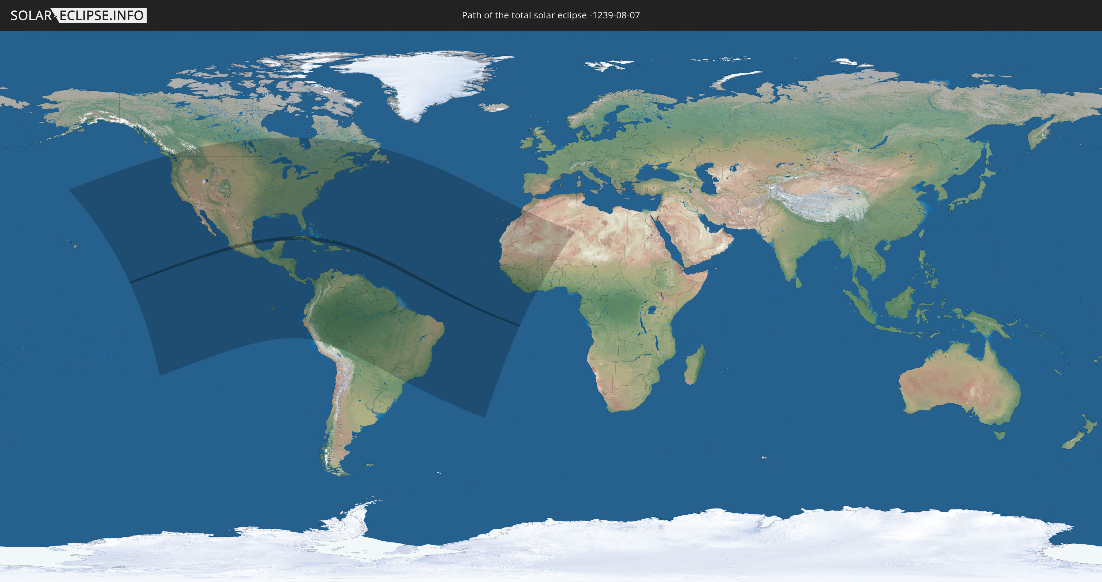
Die Sonnenfinsternis am 07.08.-1239 kann man in 65 Ländern als partielle Sonnenfinsternis beobachten.
Der Finsternispfad verläuft durch 10 Länder. Nur in diesen Ländern ist sie als totale Sonnenfinsternis zu sehen.
In den folgenden Ländern ist die Sonnenfinsternis total zu sehen
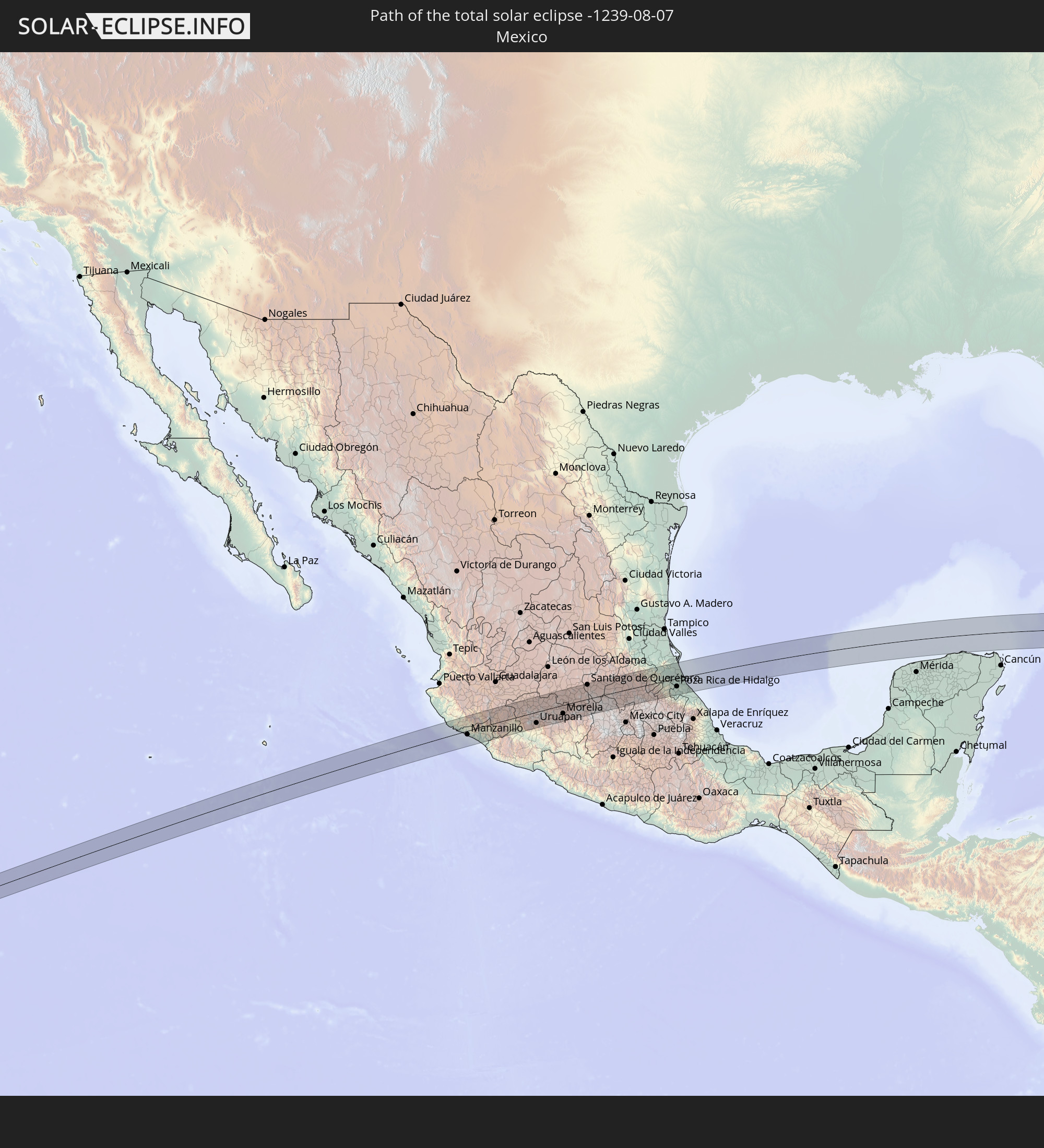 Mexiko
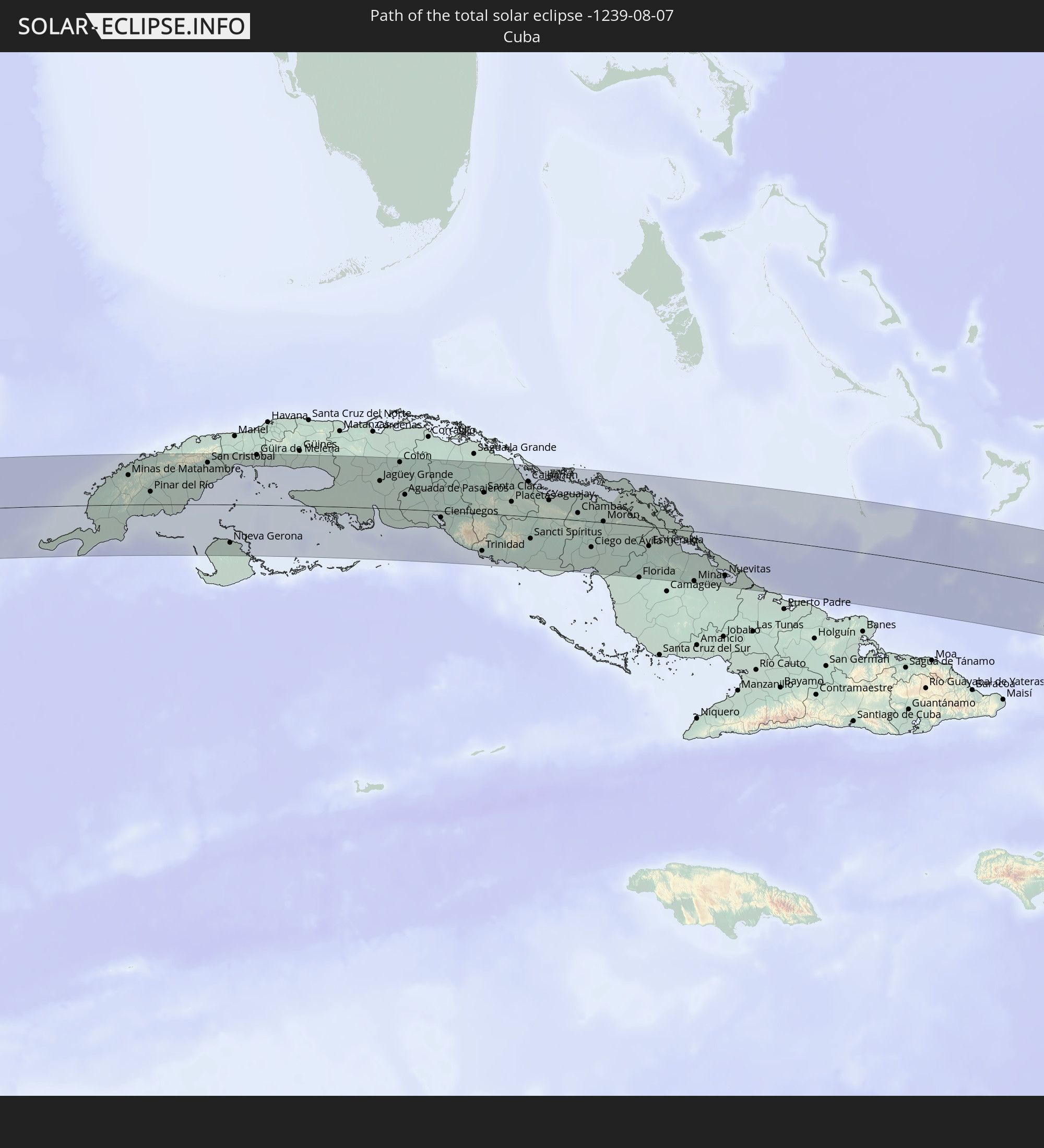 Kuba
Kuba
 Bahamas
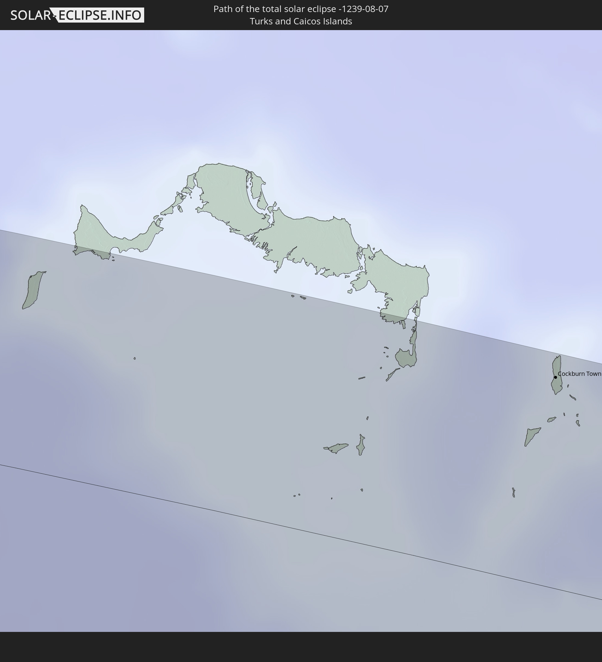 Turks- und Caicosinseln
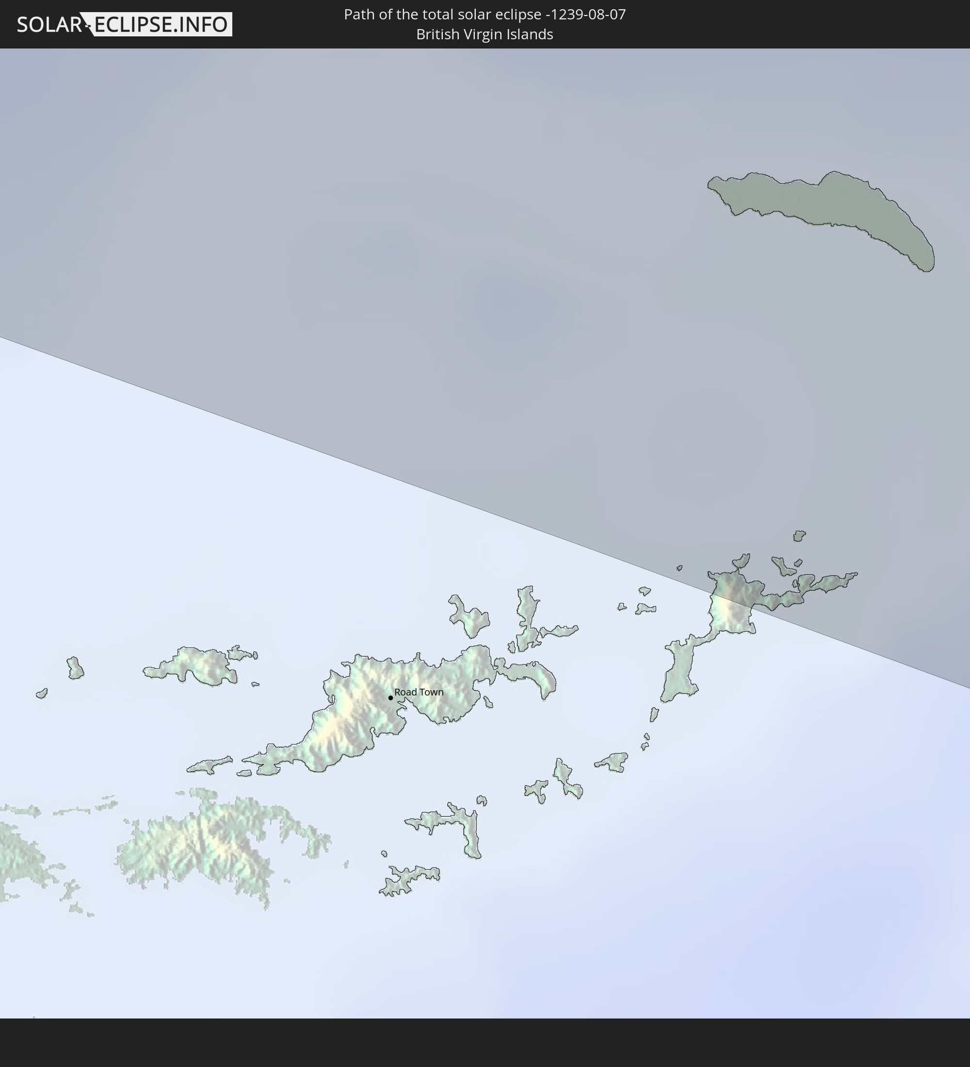 Britische Jungferninseln
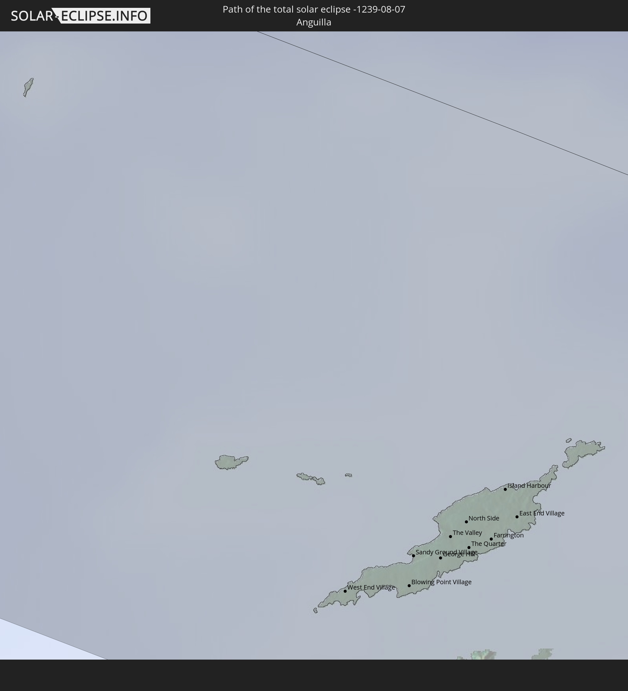 Anguilla
 Sint Maarten
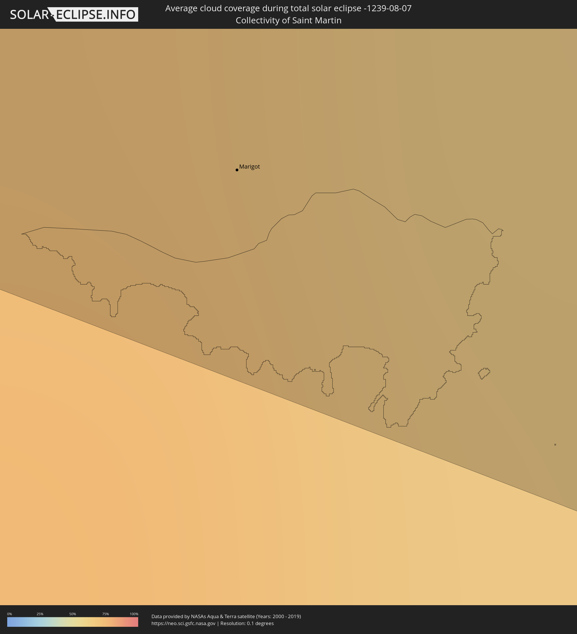
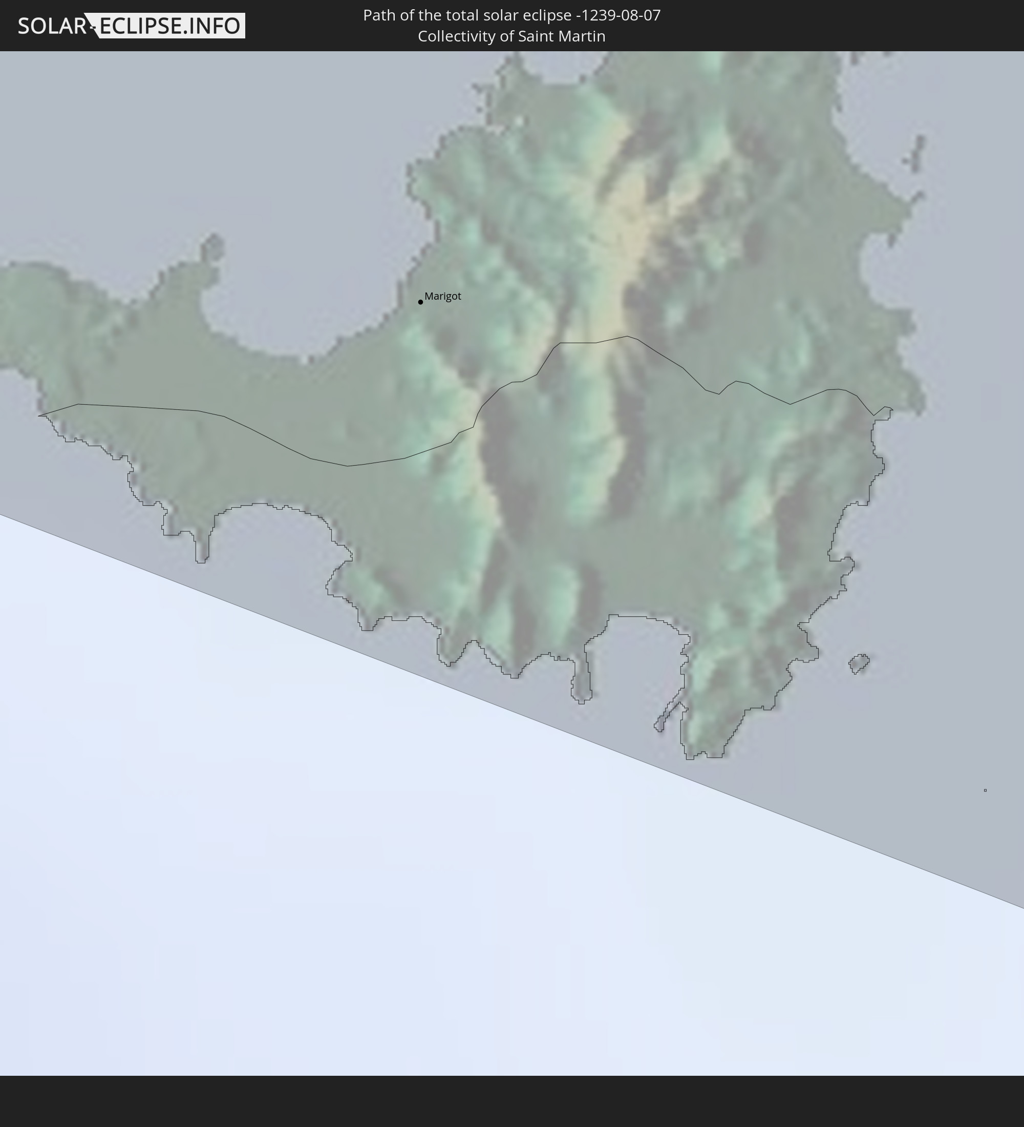 Saint-Martin
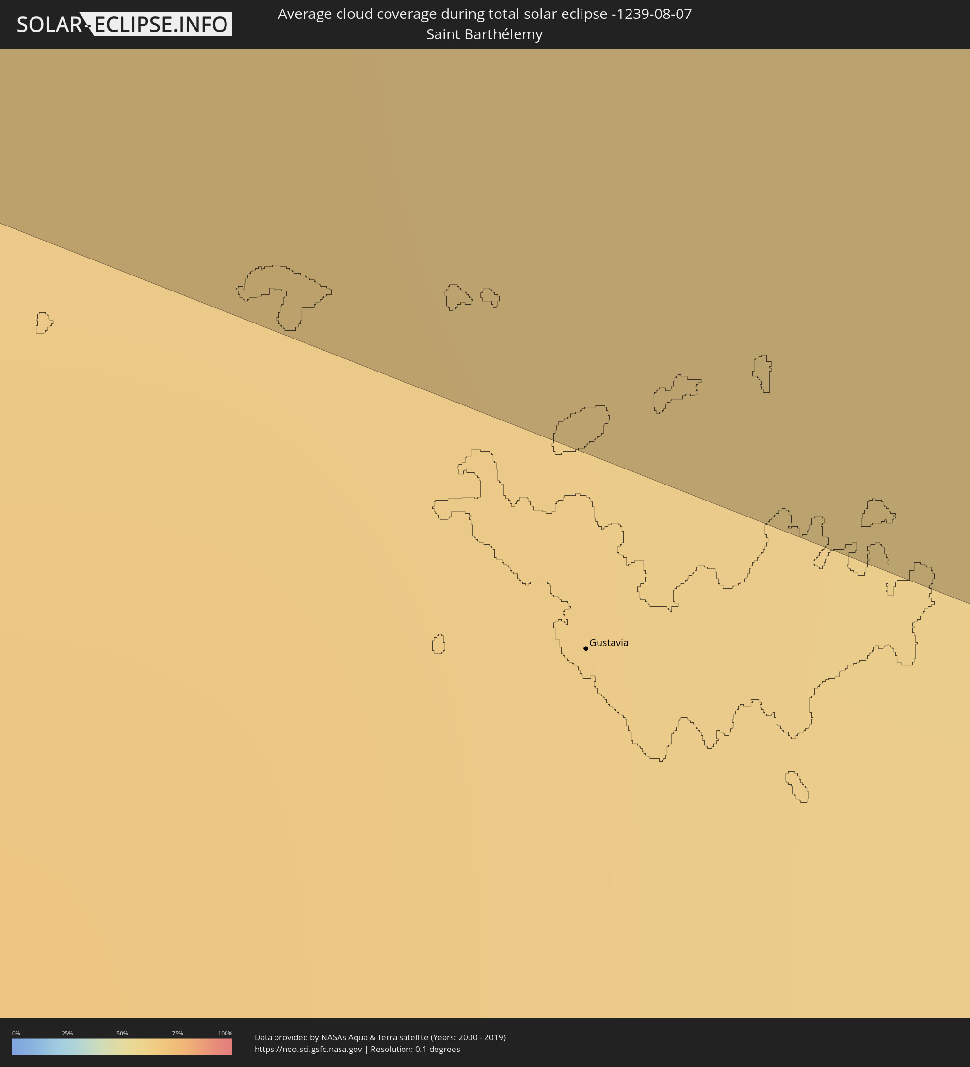
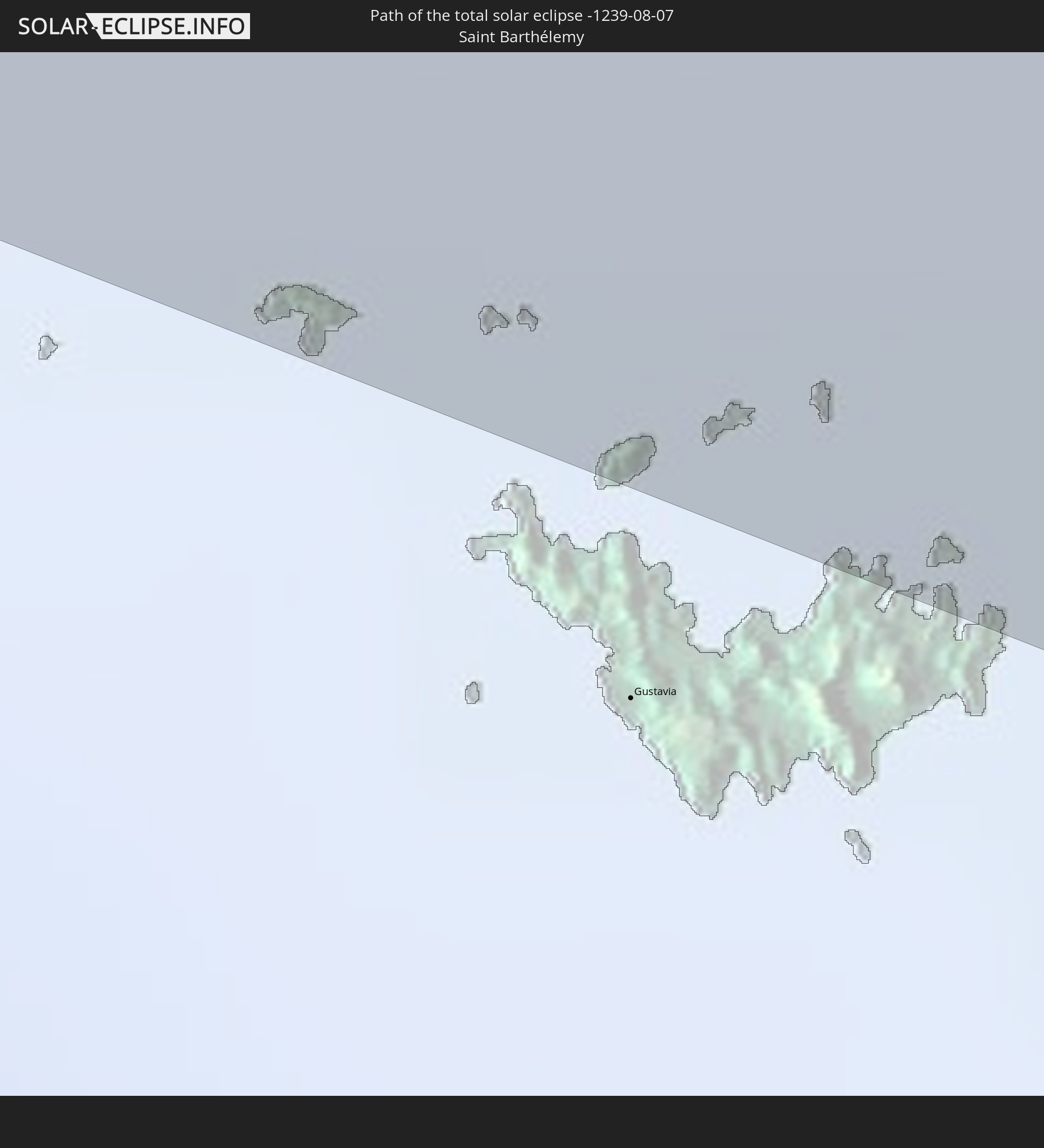 Saint-Barthélemy
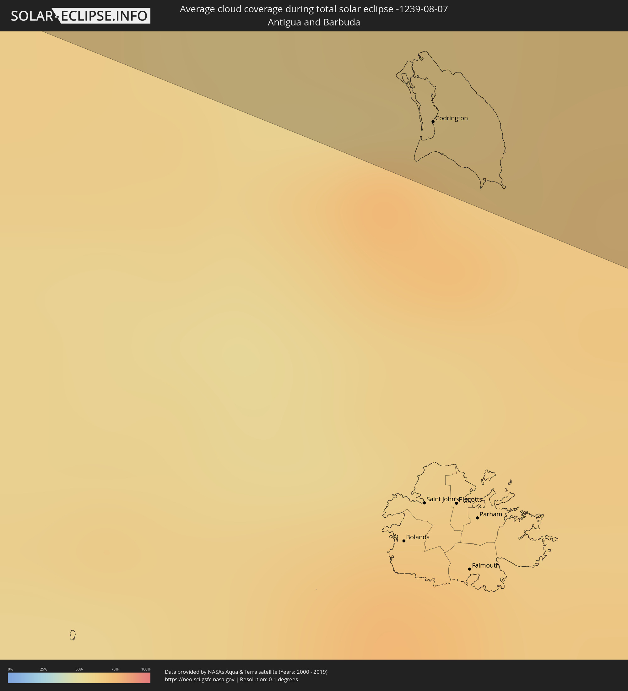
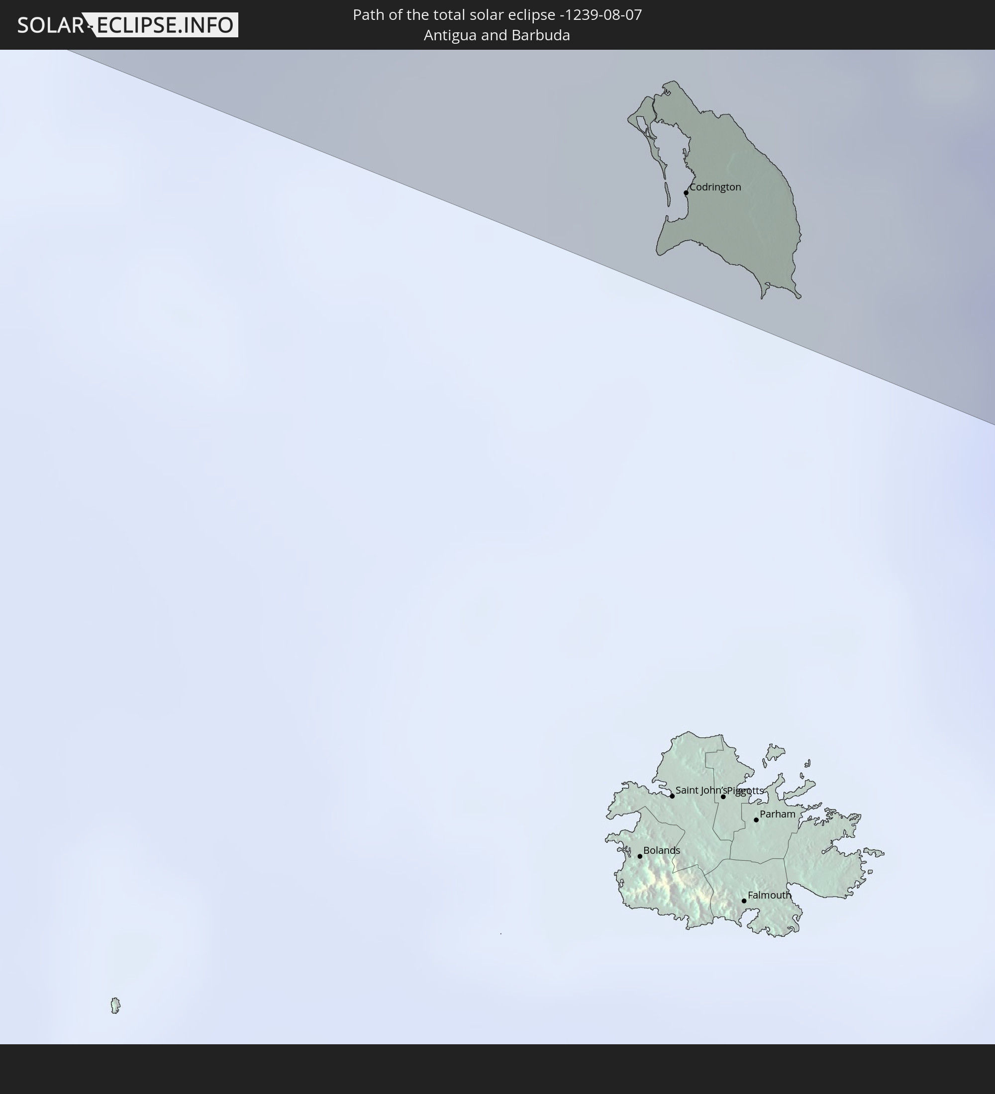 Antigua und Barbuda
In den folgenden Ländern ist die Sonnenfinsternis partiell zu sehen
 Vereinigte Staaten
 United States Minor Outlying Islands
 Kanada
 Mexiko
 Guatemala
 Ecuador
 El Salvador
 Honduras
 Belize
 Nicaragua
 Costa Rica
 Kuba
Kuba
 Panama
 Kolumbien
 Kaimaninseln
 Peru
Peru
 Bahamas
 Jamaika
 Haiti
Haiti
 Brasilien
 Venezuela
 Turks- und Caicosinseln
 Dominikanische Republik
 Aruba
Aruba
 Bolivien
 Puerto Rico
 Amerikanische Jungferninseln
 Bermuda
 Britische Jungferninseln
 Anguilla
 Saint-Martin
 Saint-Barthélemy
 St. Kitts und Nevis
 Antigua und Barbuda
 Montserrat
 Trinidad und Tobago
 Guadeloupe
 Grenada
 Dominica
 St. Vincent und die Grenadinen
 Guyana
 Martinique
 St. Lucia
 Barbados
 Suriname
 Saint-Pierre und Miquelon
 Französisch-Guayana
 Portugal
 Kap Verde
 Spanien
 Senegal
 Mauretanien
 Gambia
 Guinea-Bissau
 Guinea
 St. Helena
 Sierra Leone
 Marokko
 Mali
Mali
 Liberia
 Algerien
 Elfenbeinküste
 Burkina Faso
 Ghana
Ghana
 Niger
Niger
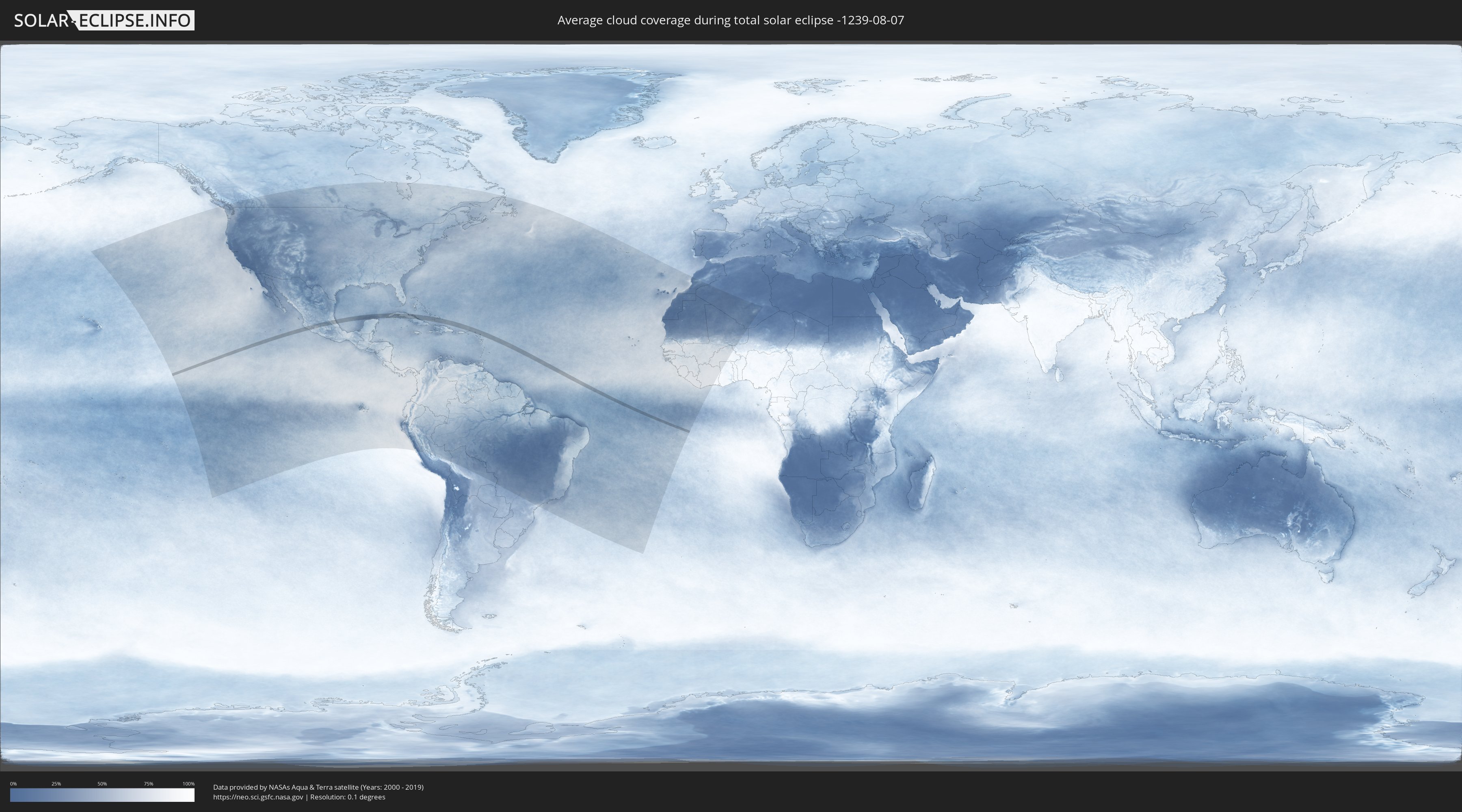
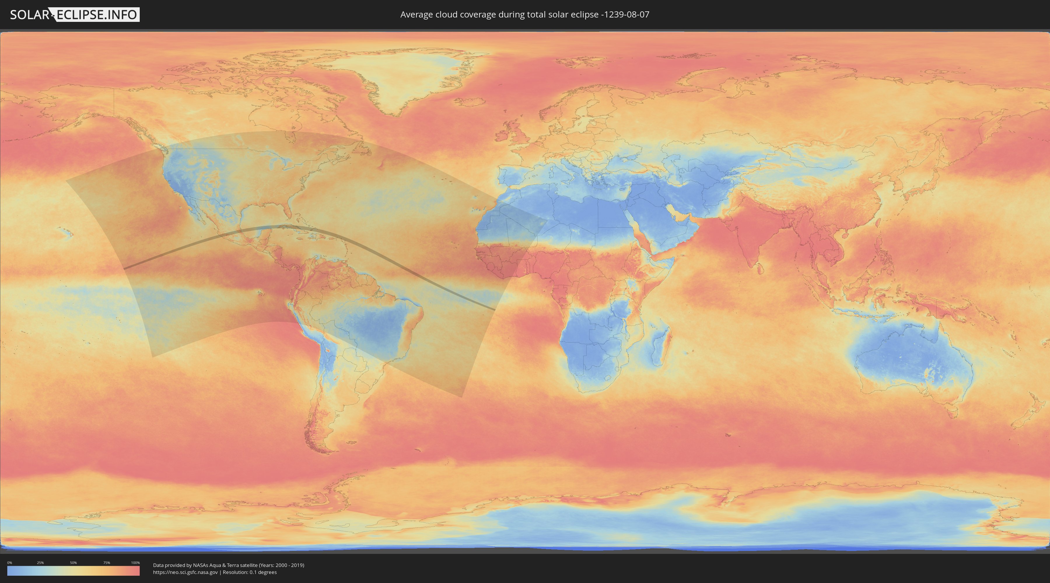
Wie wird das Wetter während der totalen Sonnenfinsternis am 07.08.-1239?
Wo ist der beste Ort, um die totale Sonnenfinsternis vom 07.08.-1239 zu beobachten?
Die folgenden Karten zeigen die durchschnittliche Bewölkung für den Tag, an dem die totale Sonnenfinsternis
stattfindet. Mit Hilfe der Karten lässt sich der Ort entlang des Finsternispfades eingrenzen,
der die besten Aussichen auf einen klaren wolkenfreien Himmel bietet.
Trotzdem muss man immer lokale Gegenenheiten beachten und sollte sich genau über das Wetter an seinem
gewählten Beobachtungsort informieren.
Die Daten stammen von den beiden NASA-Satelliten
AQUA und TERRA
und wurden über einen Zeitraum von 19 Jahren (2000 - 2019) gemittelt.
Detaillierte Länderkarten
 Mexiko
 Kuba
Kuba
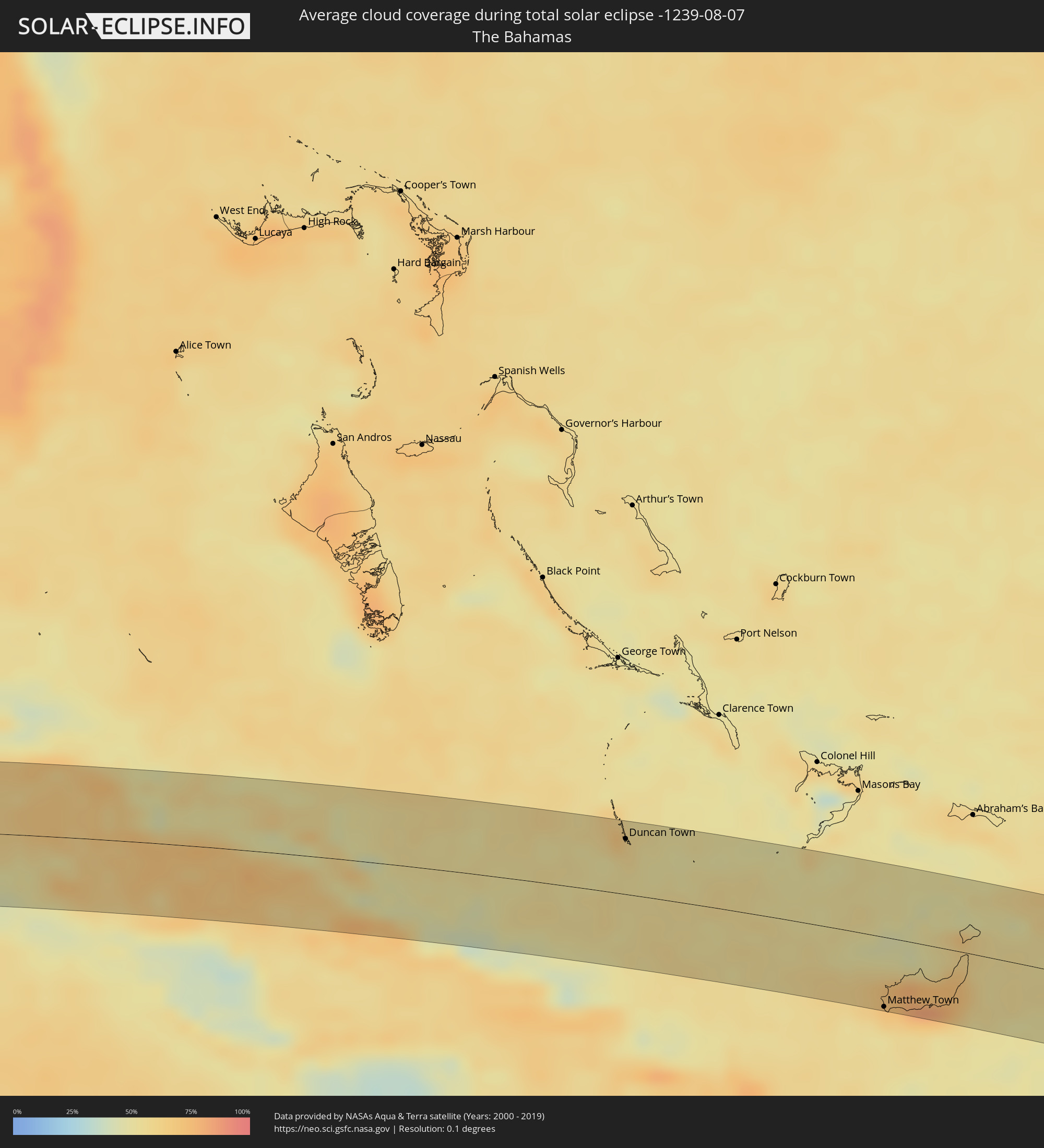 Bahamas
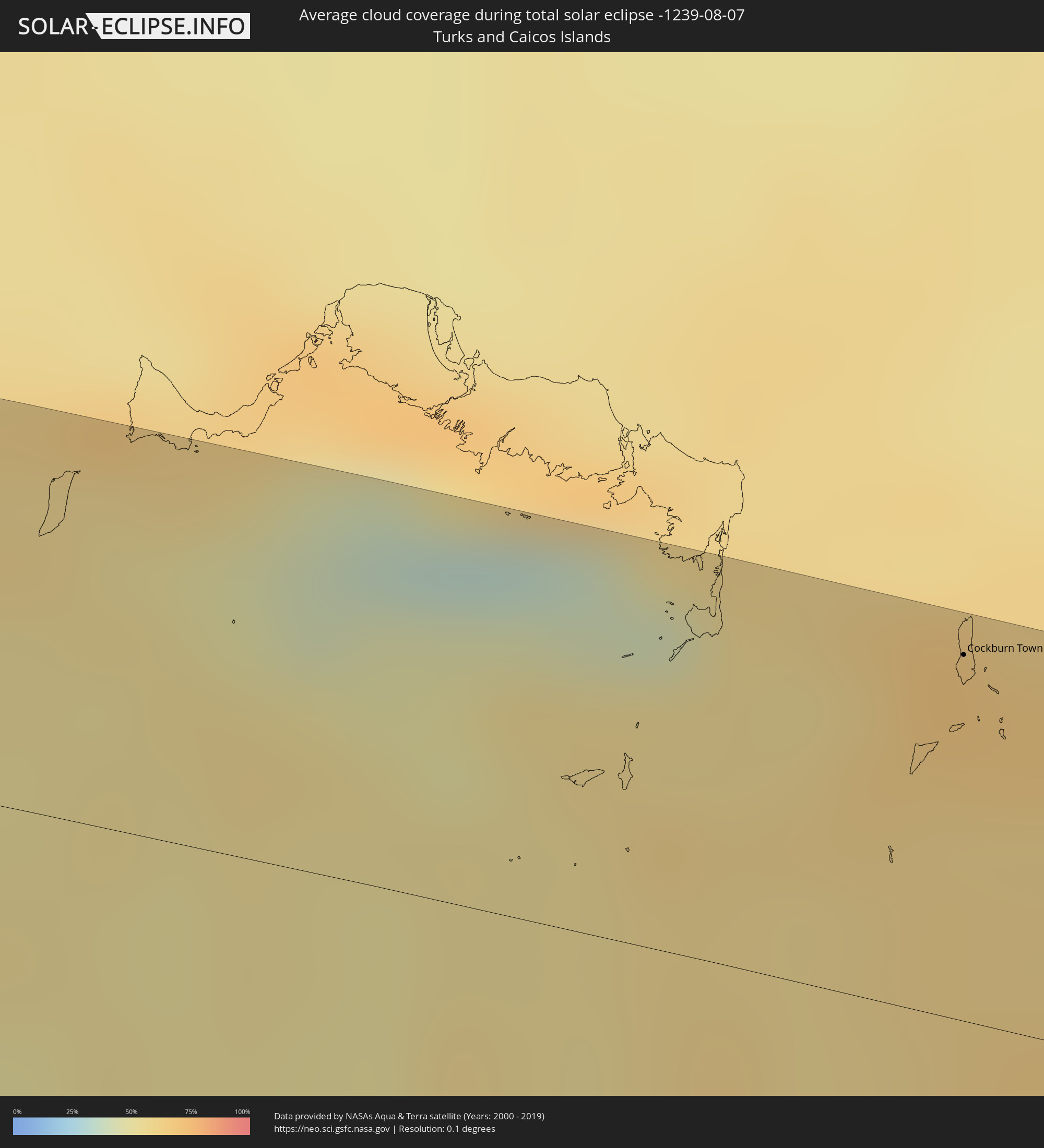 Turks- und Caicosinseln
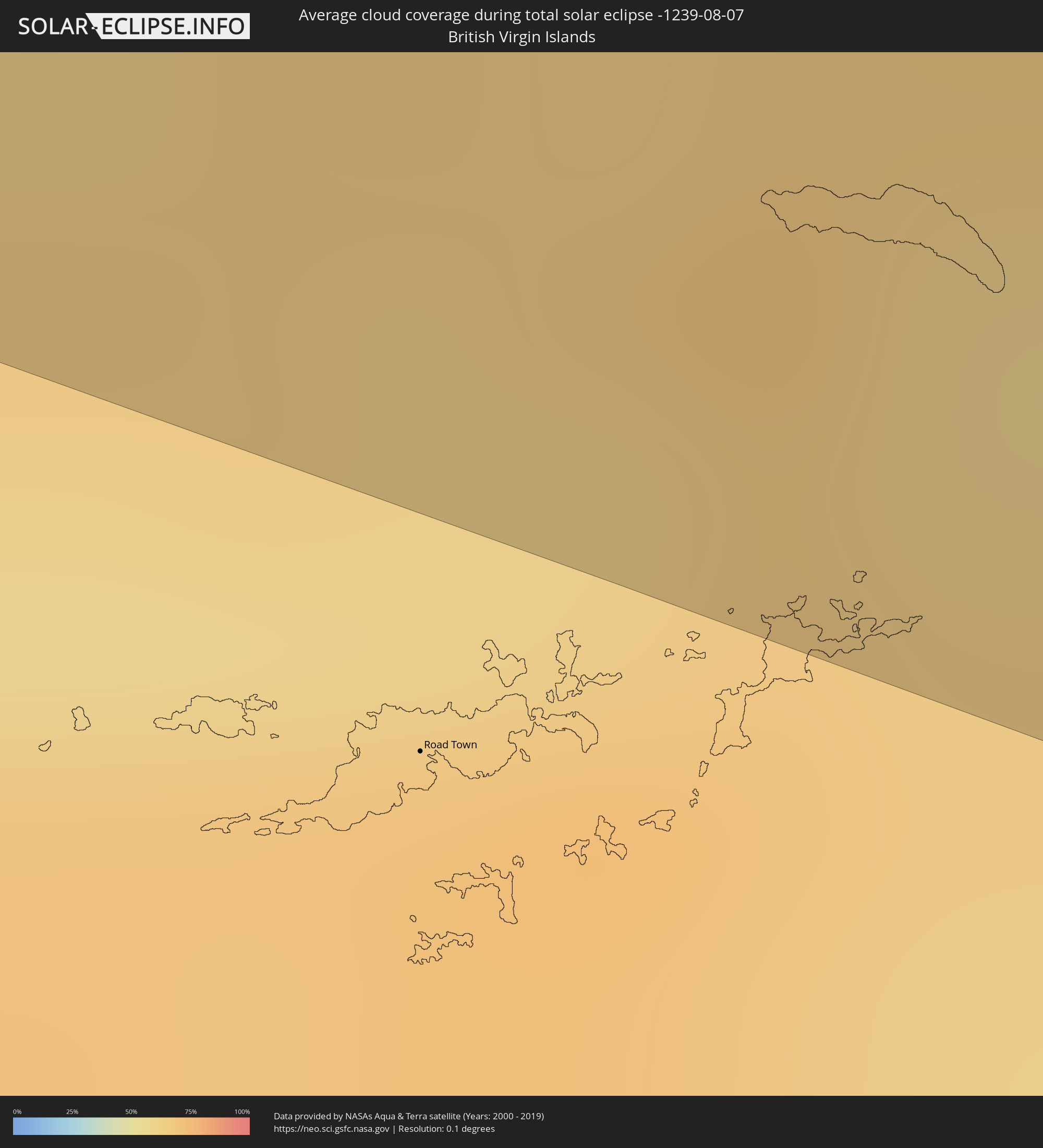 Britische Jungferninseln
 Anguilla
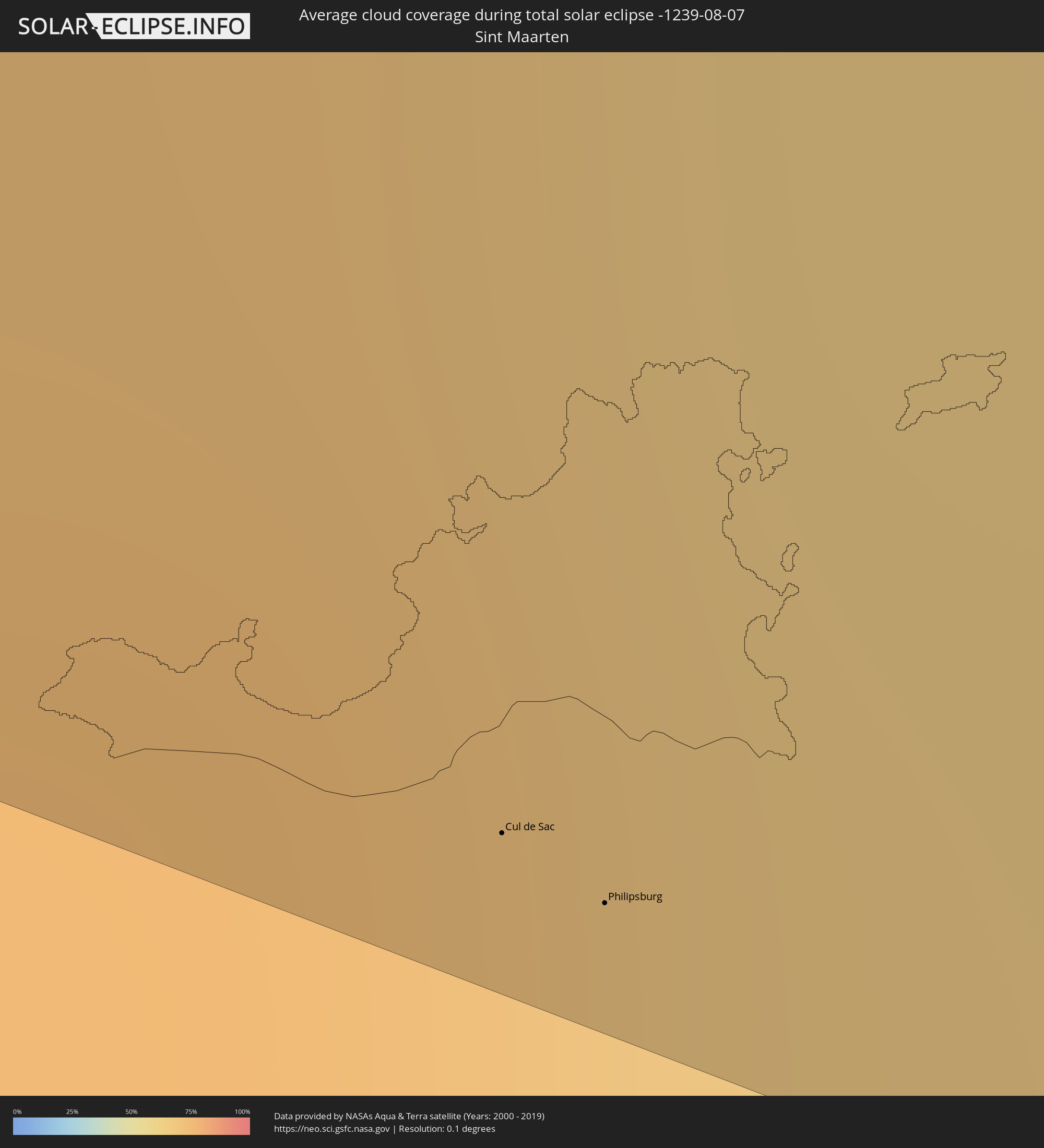 Sint Maarten
 Saint-Martin
 Saint-Barthélemy
 Antigua und Barbuda
Orte im Finsternispfad
Die nachfolgene Tabelle zeigt Städte und Orte mit mehr als 5.000 Einwohnern, die sich im Finsternispfad befinden. Städte mit mehr als 100.000 Einwohnern sind dick gekennzeichnet. Mit einem Klick auf den Ort öffnet sich eine Detailkarte die die Lage des jeweiligen Ortes zusammen mit dem Verlauf der zentralen Finsternis präsentiert.
| Ort | Typ | Dauer der Verfinsterung | Ortszeit bei maximaler Verfinsterung | Entfernung zur Zentrallinie | Ø Bewölkung |
|
Manzanillo, Colima
|
total | - | 08:49:37 UTC-06:36 | 12 km | 72% |
|
Tecoman, Colima
|
total | - | 08:50:11 UTC-06:36 | 39 km | 70% |
|
Colima, Colima
|
total | - | 08:50:37 UTC-06:36 | 8 km | 73% |
|
Ciudad Guzmán, Jalisco
|
total | - | 08:51:18 UTC-06:36 | 34 km | 69% |
|
Sahuayo de Morelos, Michoacán
|
total | - | 08:52:39 UTC-06:36 | 51 km | 57% |
|
Zamora, Michoacán
|
total | - | 08:53:16 UTC-06:36 | 32 km | 60% |
|
Uruapan, Michoacán
|
total | - | 08:53:16 UTC-06:36 | 36 km | 76% |
|
Zacapú, Michoacán
|
total | - | 08:53:57 UTC-06:36 | 0 km | 69% |
|
Pátzcuaro, Michoacán
|
total | - | 08:54:03 UTC-06:36 | 37 km | 78% |
|
Valle de Santiago, Guanajuato
|
total | - | 08:55:17 UTC-06:36 | 47 km | 49% |
|
Morelia, Michoacán
|
total | - | 08:54:52 UTC-06:36 | 28 km | 68% |
|
Uriangato, Guanajuato
|
total | - | 08:55:08 UTC-06:36 | 19 km | 54% |
|
Cortazar, Guanajuato
|
total | - | 08:55:43 UTC-06:36 | 50 km | 47% |
|
Celaya, Guanajuato
|
total | - | 08:55:59 UTC-06:36 | 51 km | 49% |
|
Acámbaro, Guanajuato
|
total | - | 08:55:50 UTC-06:36 | 4 km | 60% |
|
Ciudad Hidalgo, Michoacán
|
total | - | 08:55:54 UTC-06:36 | 45 km | 68% |
|
Santiago de Querétaro, Querétaro
|
total | - | 08:56:44 UTC-06:36 | 48 km | 48% |
|
San Juan del Río, Querétaro
|
total | - | 08:57:17 UTC-06:36 | 16 km | 50% |
|
Pachuca de Soto, Hidalgo
|
total | - | 08:59:21 UTC-06:36 | 43 km | 53% |
|
Huauchinango, Puebla
|
total | - | 09:00:37 UTC-06:36 | 53 km | 70% |
|
Xicotepec de Juárez, Puebla
|
total | - | 09:00:51 UTC-06:36 | 44 km | 72% |
|
Temapache, Veracruz
|
total | - | 09:01:54 UTC-06:36 | 35 km | 76% |
|
Poza Rica de Hidalgo, Veracruz
|
total | - | 09:01:57 UTC-06:36 | 27 km | 84% |
|
Tuxpan de Rodríguez Cano, Veracruz
|
total | - | 09:02:17 UTC-06:36 | 18 km | 63% |
|
Papantla de Olarte, Veracruz
|
total | - | 09:02:09 UTC-06:36 | 39 km | 85% |
|
Pinar del Río, Pinar del Río
|
total | - | 10:41:37 UTC-05:29 | 15 km | 72% |
|
Consolación del Sur, Pinar del Río
|
total | - | 10:42:06 UTC-05:29 | 24 km | 69% |
|
San Cristobal, Artemisa
|
total | - | 10:43:21 UTC-05:29 | 48 km | 71% |
|
Güira de Melena, Artemisa
|
total | - | 10:44:51 UTC-05:29 | 58 km | 65% |
|
Jagüey Grande, Matanzas
|
total | - | 10:48:40 UTC-05:29 | 31 km | 64% |
|
Colón, Matanzas
|
total | - | 10:49:16 UTC-05:29 | 54 km | 65% |
|
Cienfuegos, Cienfuegos
|
total | - | 10:50:38 UTC-05:29 | 7 km | 51% |
|
Santo Domingo, Villa Clara
|
total | - | 10:51:08 UTC-05:29 | 42 km | 67% |
|
Cumanayagua, Cienfuegos
|
total | - | 10:51:19 UTC-05:29 | 6 km | 52% |
|
Ranchuelo, Villa Clara
|
total | - | 10:51:26 UTC-05:29 | 19 km | 68% |
|
Cifuentes, Villa Clara
|
total | - | 10:51:40 UTC-05:29 | 51 km | 63% |
|
Trinidad, Sancti Spíritus
|
total | - | 10:52:01 UTC-05:29 | 43 km | 57% |
|
Manicaragua, Villa Clara
|
total | - | 10:51:58 UTC-05:29 | 5 km | 64% |
|
Santa Clara, Villa Clara
|
total | - | 10:51:57 UTC-05:29 | 24 km | 63% |
|
Condado, Sancti Spíritus
|
total | - | 10:52:25 UTC-05:29 | 34 km | 62% |
|
Camajuaní, Villa Clara
|
total | - | 10:52:33 UTC-05:29 | 34 km | 61% |
|
Placetas, Villa Clara
|
total | - | 10:52:51 UTC-05:29 | 16 km | 64% |
|
Cabaiguán, Sancti Spíritus
|
total | - | 10:53:21 UTC-05:29 | 9 km | 70% |
|
Caibarién, Villa Clara
|
total | - | 10:53:21 UTC-05:29 | 40 km | 52% |
|
Sancti Spíritus, Sancti Spíritus
|
total | - | 10:53:32 UTC-05:29 | 25 km | 57% |
|
Yaguajay, Sancti Spíritus
|
total | - | 10:54:03 UTC-05:29 | 20 km | 71% |
|
Ciego de Ávila, Ciego de Ávila
|
total | - | 10:55:32 UTC-05:29 | 30 km | 68% |
|
Morón, Ciego de Ávila
|
total | - | 10:55:51 UTC-05:29 | 1 km | 71% |
|
Florida, Camagüey
|
partiell | - | 10:57:11 UTC-05:29 | 59 km | 64% |
|
Nuevitas, Camagüey
|
total | - | 11:00:00 UTC-05:29 | 47 km | 49% |
|
Duncan Town, Ragged Island
|
total | - | 11:24:21 UTC-05:09 | 45 km | 57% |
|
Matthew Town, Inagua
|
total | - | 11:31:04 UTC-05:09 | 57 km | 52% |
|
Cockburn Town
|
total | - | 11:40:32 UTC-05:07 | 54 km | 66% |
|
West End Village, West End
|
total | - | 13:07:30 UTC-04:06 | 45 km | 70% |
|
Blowing Point Village, Blowing Point
|
total | - | 13:07:39 UTC-04:06 | 42 km | 70% |
|
Sandy Ground Village, Sandy Ground
|
total | - | 13:07:38 UTC-04:06 | 40 km | 70% |
|
South Hill Village, South Hill
|
total | - | 13:07:38 UTC-04:06 | 41 km | 70% |
|
Marigot
|
total | - | 13:07:48 UTC-04:06 | 53 km | 73% |
|
North Hill Village, North Hill
|
total | - | 13:07:39 UTC-04:06 | 39 km | 70% |
|
George Hill, George Hill
|
total | - | 13:07:41 UTC-04:06 | 39 km | 70% |
 Cul de Sac
|
total | - | 12:38:10 UTC-04:35 | 56 km | 67% |
|
The Valley, The Valley
|
total | - | 13:07:42 UTC-04:06 | 37 km | 70% |
|
Stoney Ground, Stoney Ground
|
total | - | 13:07:43 UTC-04:06 | 36 km | 64% |
|
Philipsburg
|
total | - | 12:38:14 UTC-04:35 | 56 km | 66% |
|
North Side, North Side
|
total | - | 13:07:43 UTC-04:06 | 35 km | 64% |
|
The Quarter, The Quarter
|
total | - | 13:07:45 UTC-04:06 | 37 km | 64% |
|
Farrington, The Farrington
|
total | - | 13:07:48 UTC-04:06 | 36 km | 64% |
|
Sandy Hill, Sandy Hill
|
total | - | 13:07:49 UTC-04:06 | 35 km | 64% |
|
Island Harbour, Island Harbour
|
total | - | 13:07:47 UTC-04:06 | 31 km | 64% |
|
East End Village, East End
|
total | - | 13:07:50 UTC-04:06 | 33 km | 64% |
|
Codrington, Barbuda
|
total | - | 13:11:38 UTC-04:06 | 49 km | 72% |