Totale Sonnenfinsternis vom 01.05.2079
| Wochentag: | Montag |
| Maximale Dauer der Verfinsterung: | 02m55s |
| Maximale Breite des Finsternispfades: | 406 km |
| Saroszyklus: | 149 |
| Bedeckungsgrad: | 100% |
| Magnitude: | 1.0512 |
| Gamma: | 0.9081 |
Wo kann man die Sonnenfinsternis vom 01.05.2079 sehen?
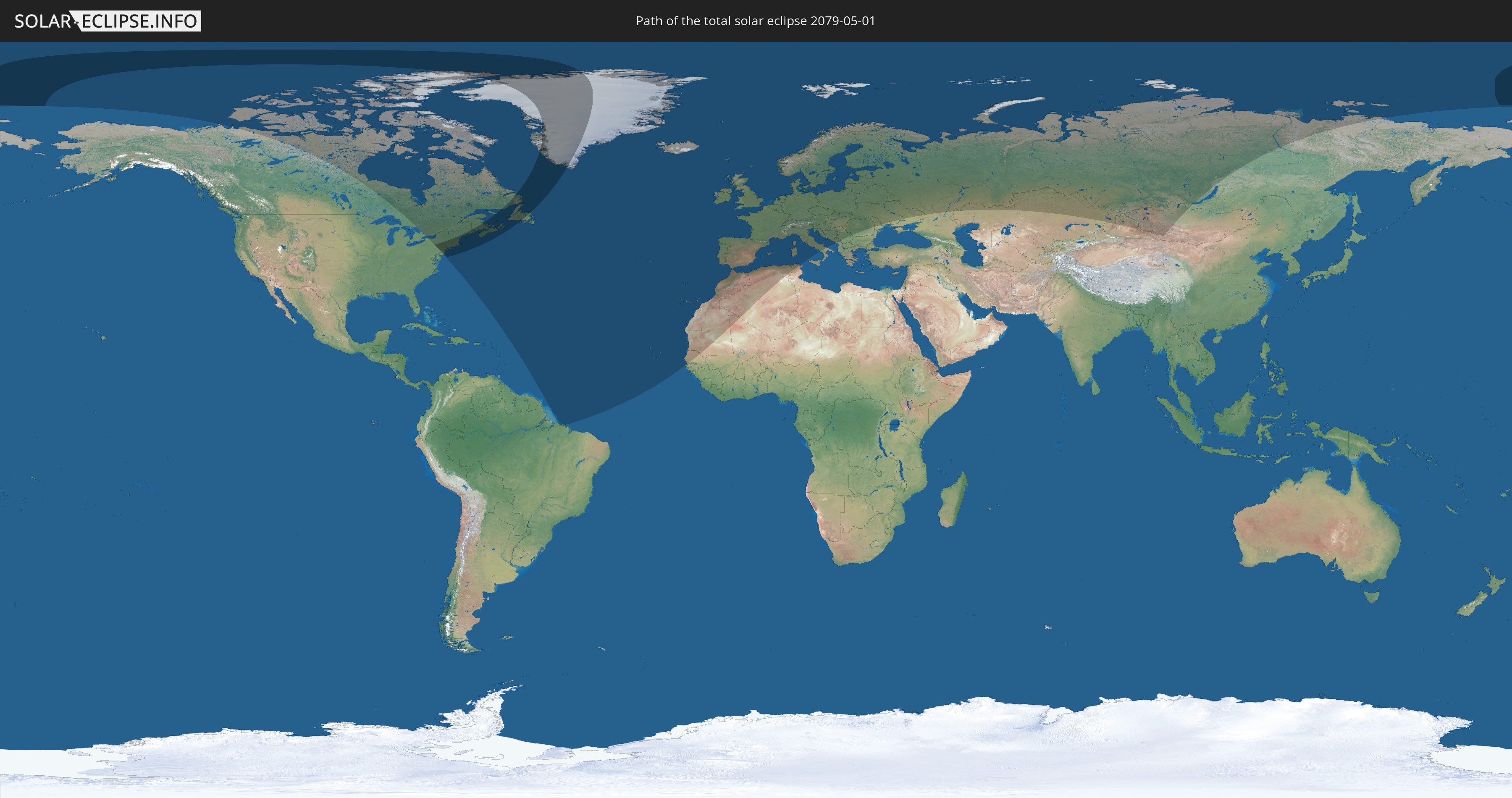
Die Sonnenfinsternis am 01.05.2079 kann man in 65 Ländern als partielle Sonnenfinsternis beobachten.
Der Finsternispfad verläuft durch 3 Länder. Nur in diesen Ländern ist sie als totale Sonnenfinsternis zu sehen.
In den folgenden Ländern ist die Sonnenfinsternis total zu sehen
 Vereinigte Staaten
 Kanada
 Grönland
In den folgenden Ländern ist die Sonnenfinsternis partiell zu sehen
 Russland
 Vereinigte Staaten
 Kanada
 Grönland
 Brasilien
 Bermuda
 Saint-Pierre und Miquelon
 Portugal
 Kap Verde
 Island
 Spanien
 Senegal
 Mauretanien
 Gambia
 Marokko
 Mali
Mali
 Irland
 Spitzbergen
 Algerien
 Vereinigtes Königreich
 Färöer
 Gibraltar
 Frankreich
 Isle of Man
 Guernsey
 Jersey
 Andorra
 Belgien
 Niederlande
 Norwegen
 Luxemburg
 Deutschland
 Schweiz
 Italien
 Monaco
 Tunesien
 Dänemark
 Liechtenstein
 Österreich
 Schweden
 Tschechien
 San Marino
 Vatikanstadt
 Slowenien
 Kroatien
 Polen
Polen
 Bosnien und Herzegowina
 Ungarn
 Slowakei
 Montenegro
 Serbien
 Albanien
 Åland Islands
 Rumänien
 Finnland
 Litauen
 Lettland
 Estland
 Ukraine
 Bulgarien
 Weißrussland
 Moldawien
 Kasachstan
 Volksrepublik China
 Mongolei
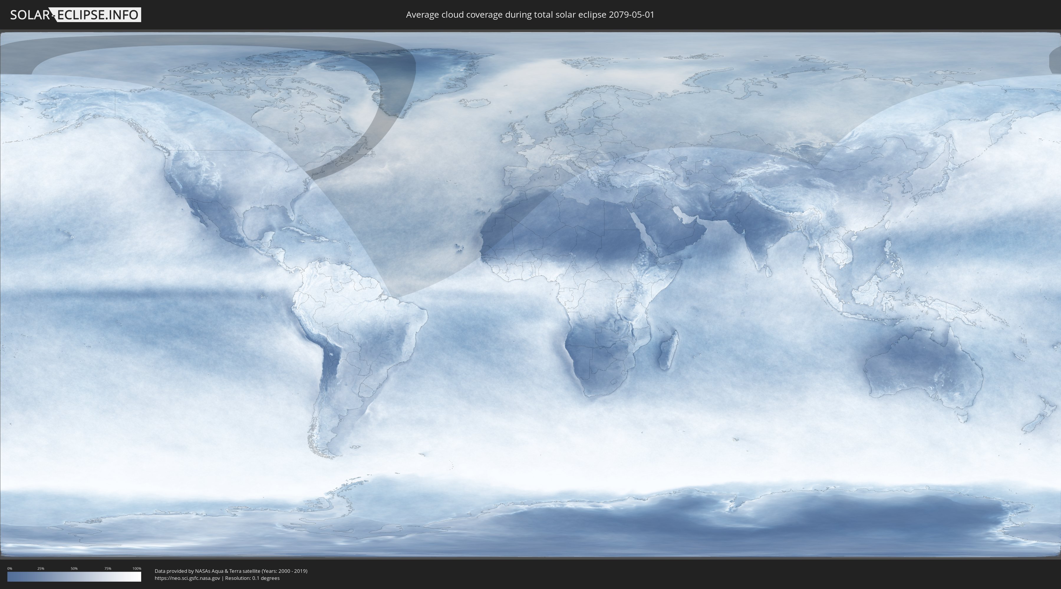
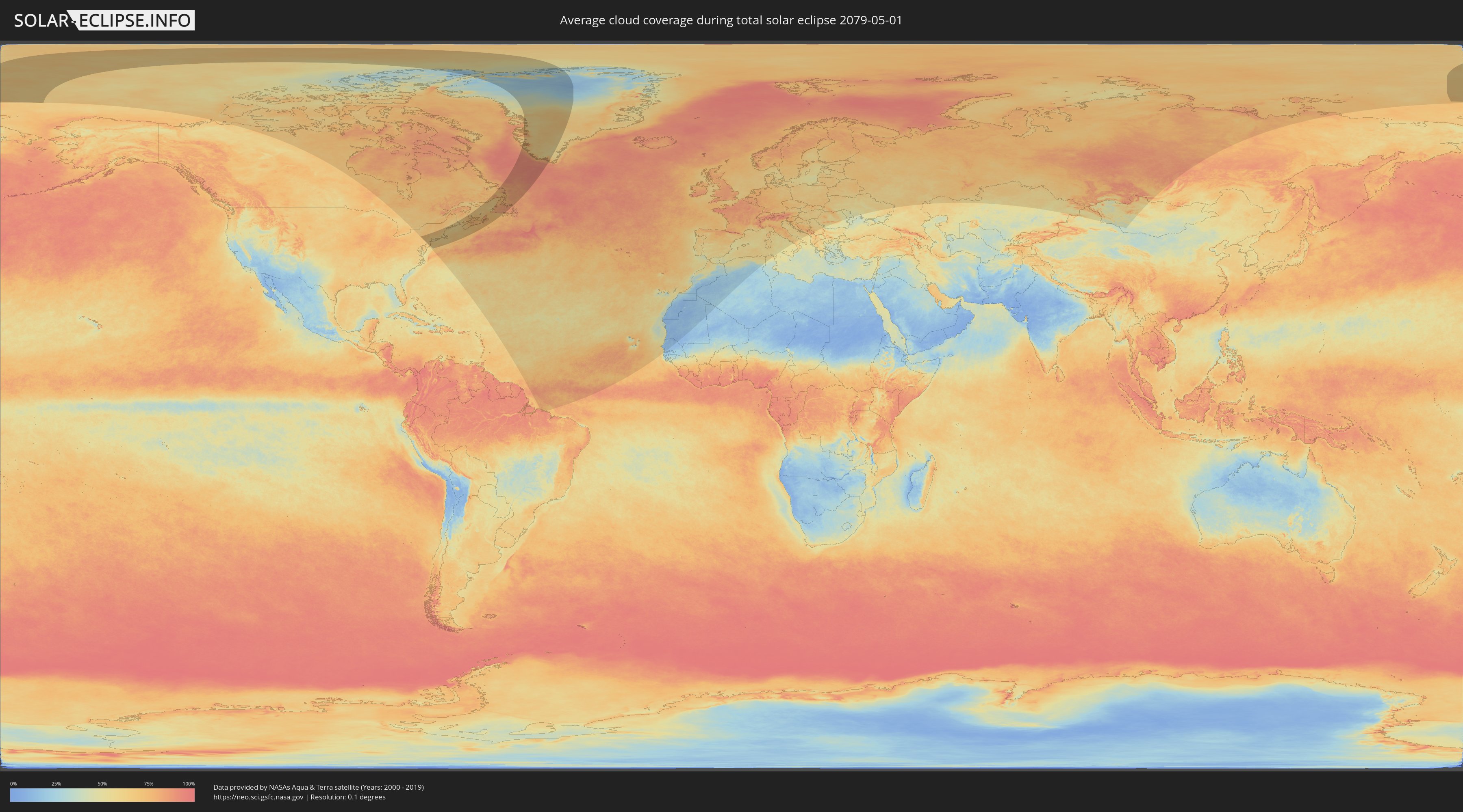
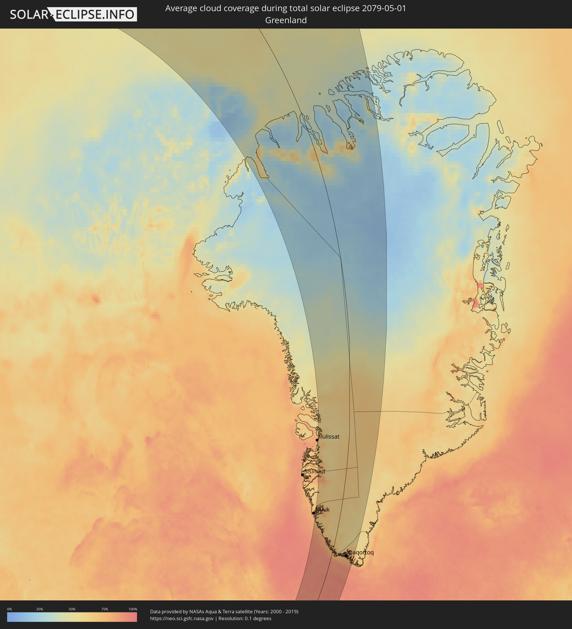
Wie wird das Wetter während der totalen Sonnenfinsternis am 01.05.2079?
Wo ist der beste Ort, um die totale Sonnenfinsternis vom 01.05.2079 zu beobachten?
Die folgenden Karten zeigen die durchschnittliche Bewölkung für den Tag, an dem die totale Sonnenfinsternis
stattfindet. Mit Hilfe der Karten lässt sich der Ort entlang des Finsternispfades eingrenzen,
der die besten Aussichen auf einen klaren wolkenfreien Himmel bietet.
Trotzdem muss man immer lokale Gegenenheiten beachten und sollte sich genau über das Wetter an seinem
gewählten Beobachtungsort informieren.
Die Daten stammen von den beiden NASA-Satelliten
AQUA und TERRA
und wurden über einen Zeitraum von 19 Jahren (2000 - 2019) gemittelt.
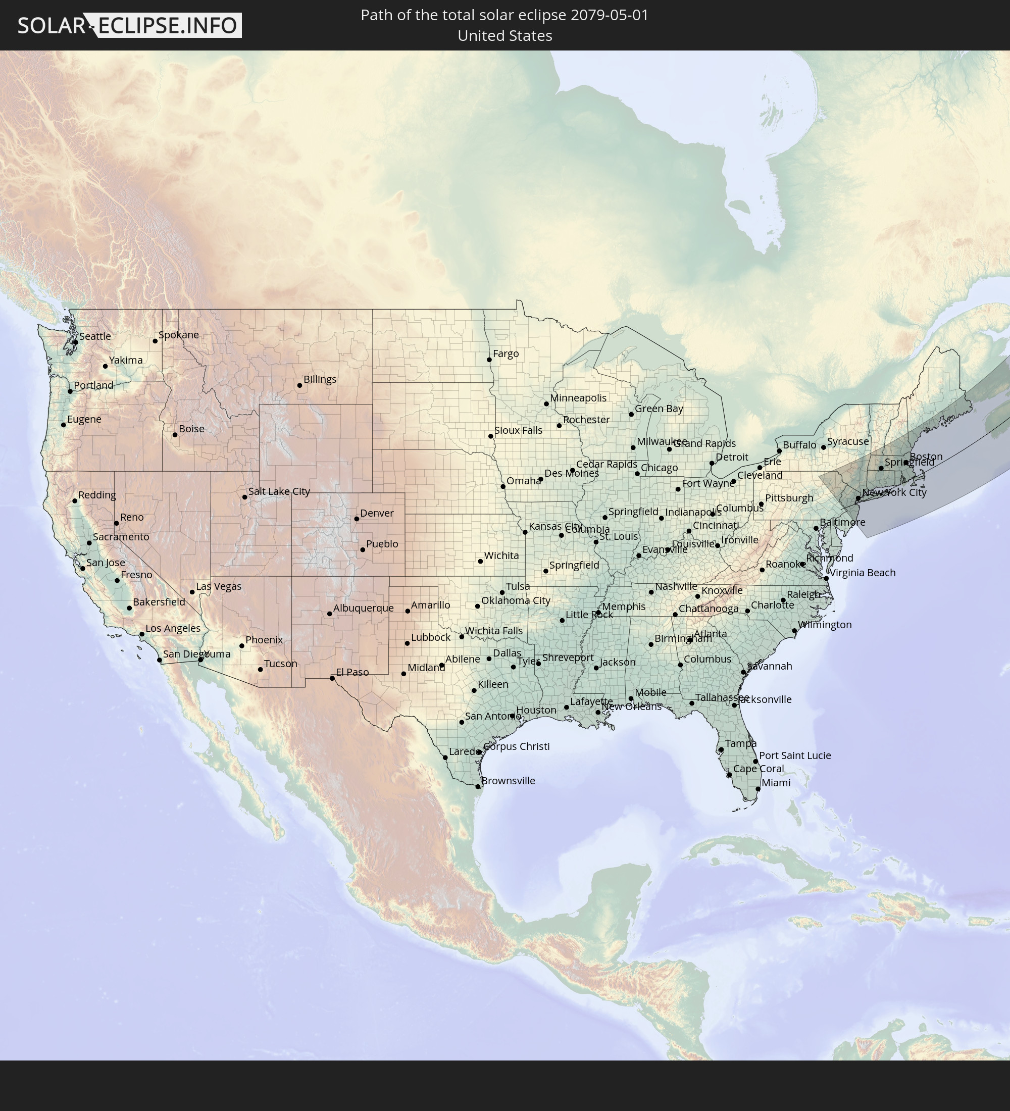
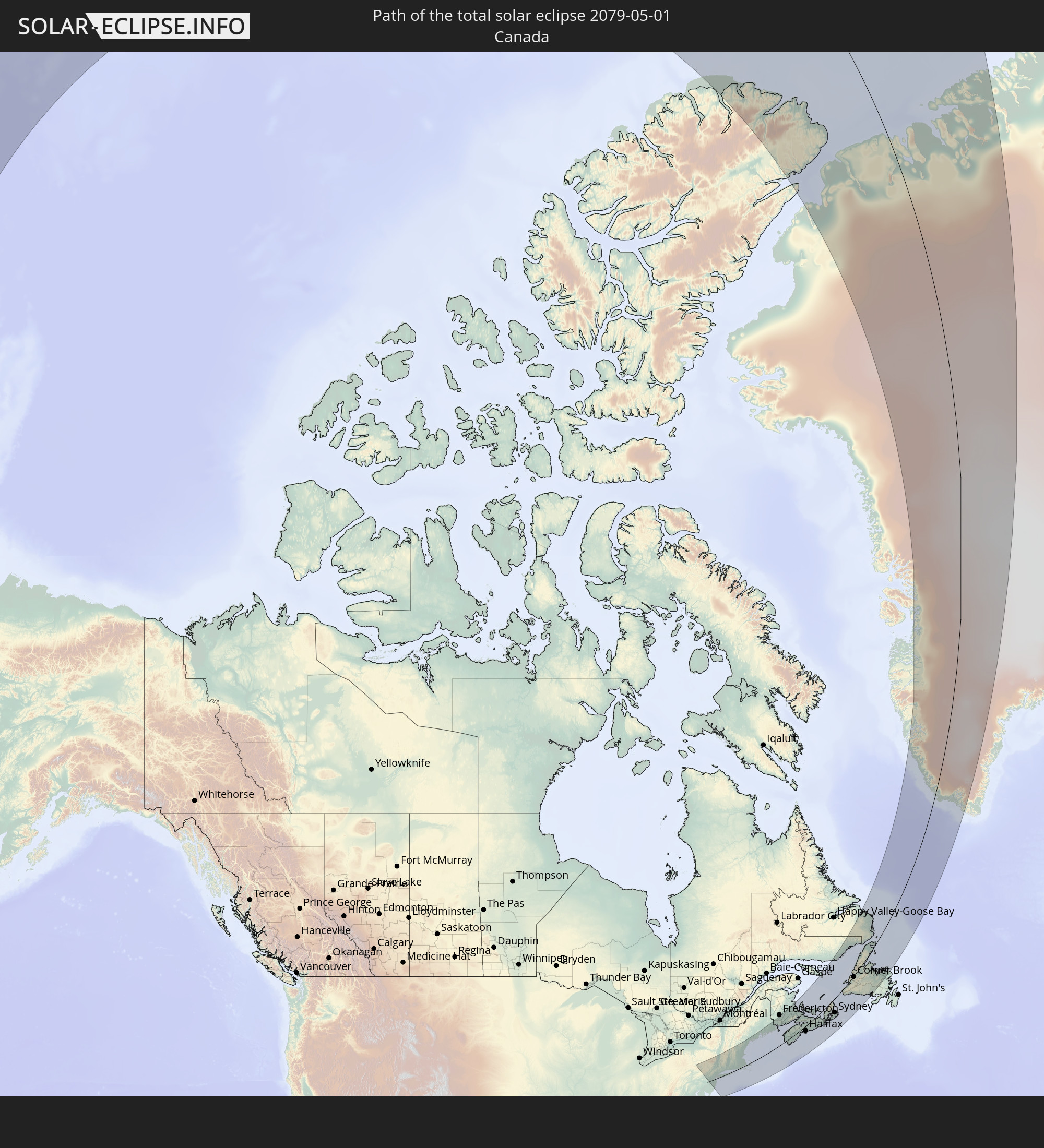
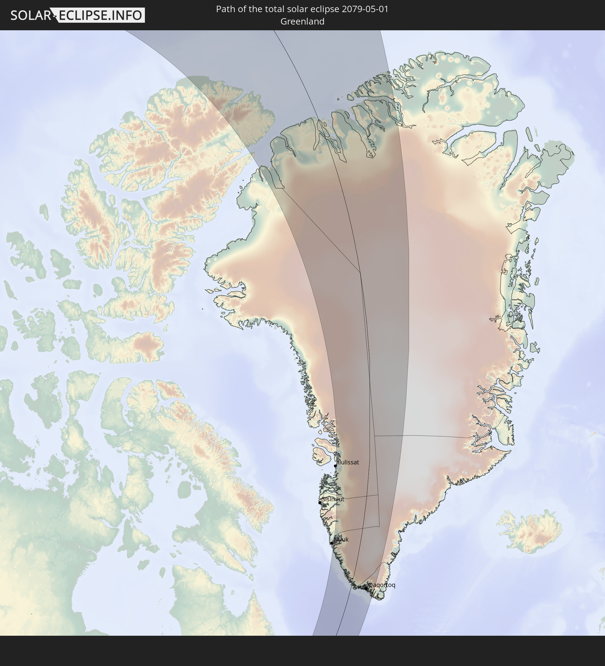
Detaillierte Länderkarten
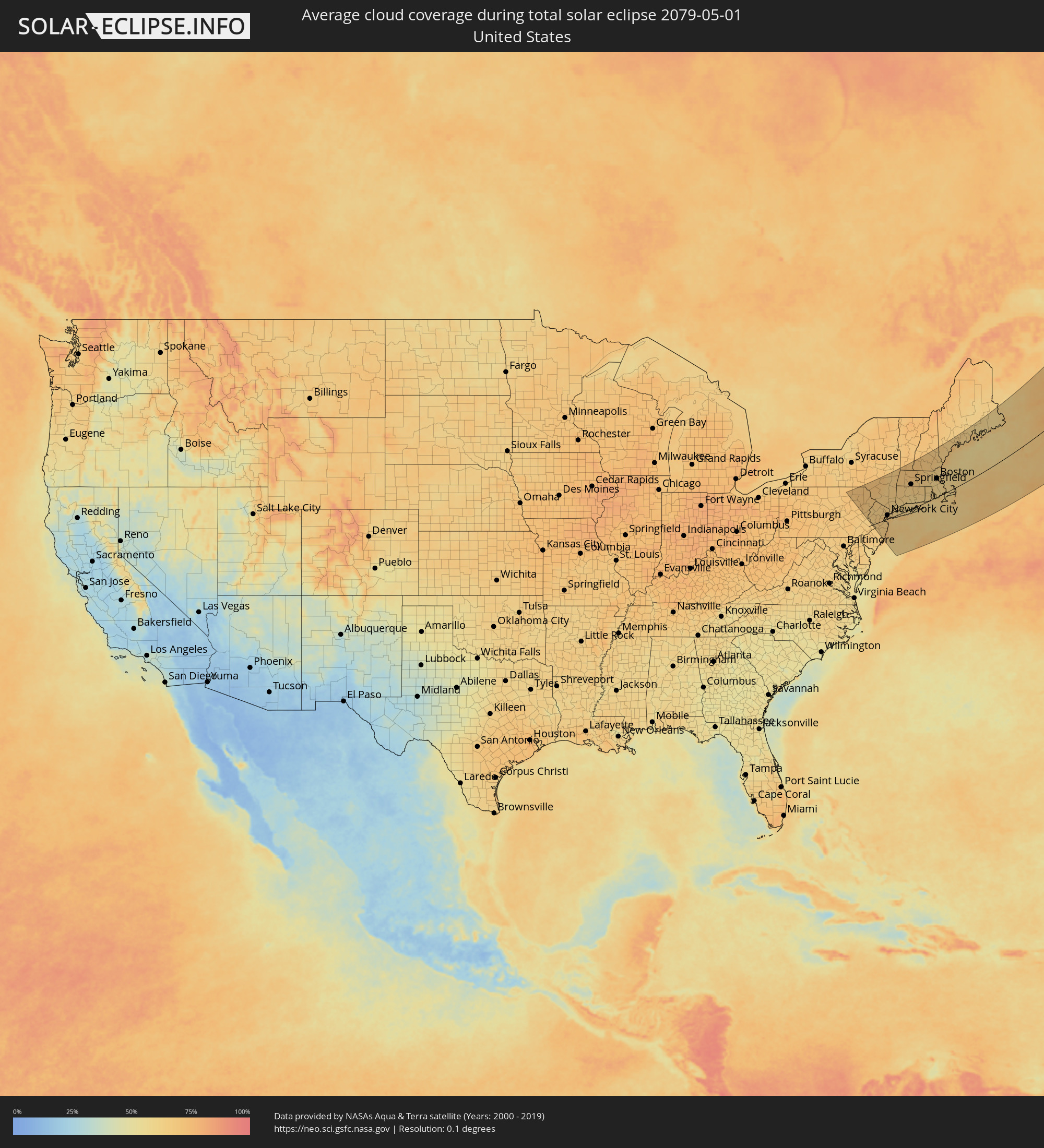 Vereinigte Staaten
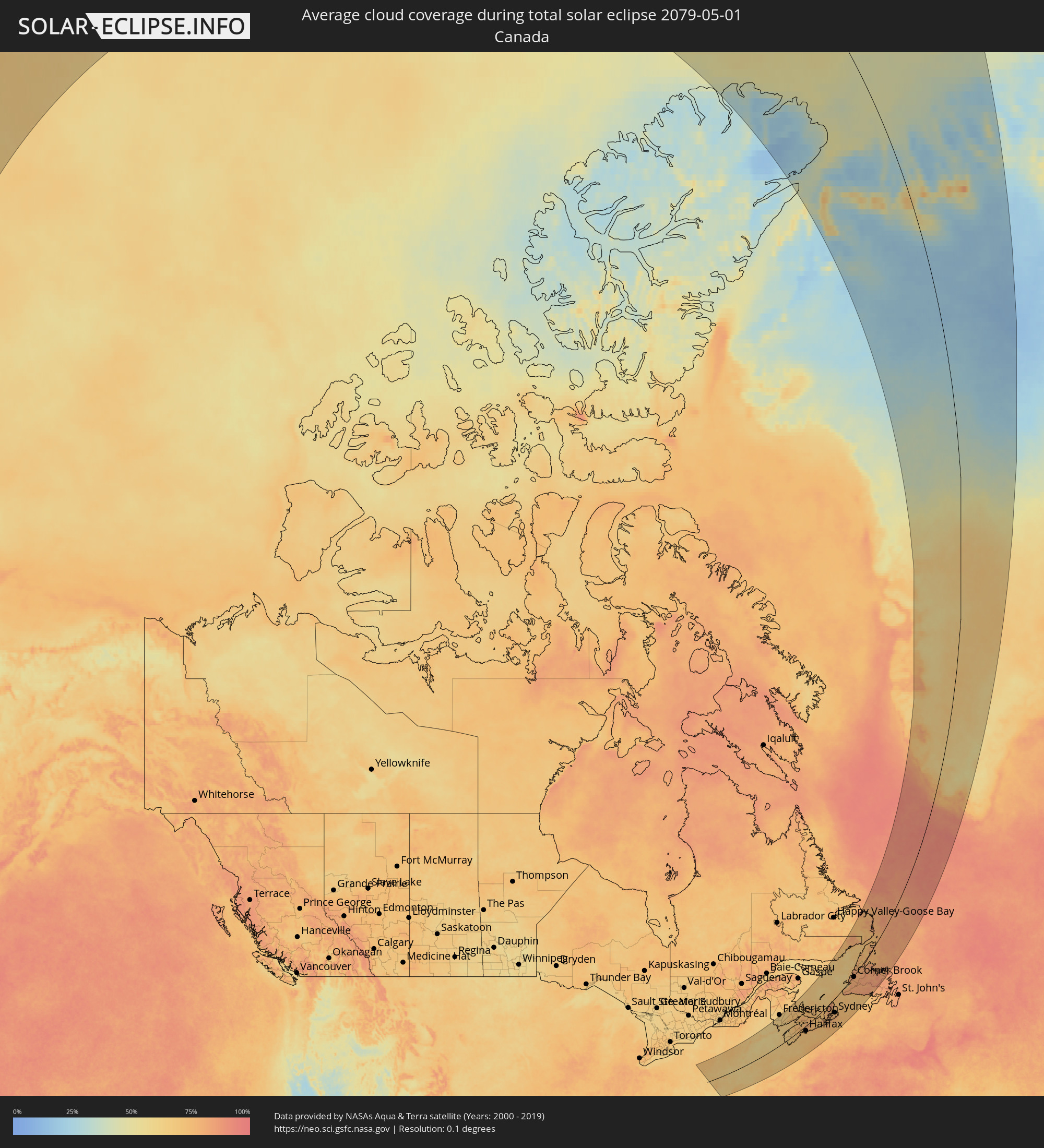 Kanada
 Grönland
Orte im Finsternispfad
Die nachfolgene Tabelle zeigt Städte und Orte mit mehr als 5.000 Einwohnern, die sich im Finsternispfad befinden. Städte mit mehr als 100.000 Einwohnern sind dick gekennzeichnet. Mit einem Klick auf den Ort öffnet sich eine Detailkarte die die Lage des jeweiligen Ortes zusammen mit dem Verlauf der zentralen Finsternis präsentiert.
| Ort | Typ | Dauer der Verfinsterung | Ortszeit bei maximaler Verfinsterung | Entfernung zur Zentrallinie | Ø Bewölkung |
|
Wilkes-Barre, Pennsylvania
|
total | - | 05:06:17 UTC-05:00 | 131 km | 68% |
|
Scranton, Pennsylvania
|
total | - | 05:06:26 UTC-05:00 | 140 km | 70% |
|
Trenton, New Jersey
|
total | - | 05:04:22 UTC-05:00 | 12 km | 65% |
|
Bridgewater, New Jersey
|
total | - | 05:04:52 UTC-05:00 | 25 km | 67% |
|
Parsippany, New Jersey
|
total | - | 05:05:09 UTC-05:00 | 45 km | 65% |
|
Middletown, New York
|
total | - | 05:06:00 UTC-05:00 | 106 km | 65% |
|
Edison, New Jersey
|
total | - | 05:04:40 UTC-05:00 | 10 km | 67% |
|
Westfield, New Jersey
|
total | - | 05:04:50 UTC-05:00 | 22 km | 66% |
|
Marlboro, New Jersey
|
total | - | 05:04:19 UTC-05:00 | 16 km | 67% |
|
Lakewood, New Jersey
|
total | - | 05:03:59 UTC-05:00 | 40 km | 68% |
|
East Orange, New Jersey
|
total | - | 05:04:57 UTC-05:00 | 29 km | 63% |
|
Toms River, New Jersey
|
total | - | 05:03:46 UTC-05:00 | 55 km | 68% |
|
Paterson, New Jersey
|
total | - | 05:05:09 UTC-05:00 | 44 km | 64% |
|
Staten Island, New York
|
total | - | 05:04:37 UTC-05:00 | 6 km | 67% |
|
Newburgh, New York
|
total | - | 05:05:56 UTC-05:00 | 99 km | 66% |
|
New York City, New York
|
total | - | 05:04:47 UTC-05:00 | 17 km | 68% |
|
Long Branch, New Jersey
|
total | - | 05:04:12 UTC-05:00 | 25 km | 68% |
|
New City, New York
|
total | - | 05:05:25 UTC-05:00 | 62 km | 64% |
|
Poughkeepsie, New York
|
total | - | 05:06:11 UTC-05:00 | 116 km | 66% |
|
The Bronx, New York
|
total | - | 05:04:56 UTC-05:00 | 27 km | 66% |
|
Greenburgh, New York
|
total | - | 05:05:11 UTC-05:00 | 45 km | 62% |
|
Jamaica, New York
|
total | - | 05:04:41 UTC-05:00 | 9 km | 66% |
|
Hempstead, New York
|
total | - | 05:04:38 UTC-05:00 | 4 km | 63% |
|
Stamford, Connecticut
|
total | - | 05:05:07 UTC-05:00 | 37 km | 63% |
|
Danbury, Connecticut
|
total | - | 05:05:35 UTC-05:00 | 70 km | 63% |
|
Huntington Station, New York
|
total | - | 05:04:46 UTC-05:00 | 13 km | 61% |
|
Brentwood, New York
|
total | - | 05:04:36 UTC-05:00 | 0 km | 64% |
|
Pittsfield, Massachusetts
|
total | - | 05:07:03 UTC-05:00 | 170 km | 69% |
|
Bridgeport, Connecticut
|
total | - | 05:05:09 UTC-05:00 | 38 km | 63% |
|
Torrington, Connecticut
|
total | - | 05:06:03 UTC-05:00 | 100 km | 65% |
|
Waterbury, Connecticut
|
total | - | 05:05:40 UTC-05:00 | 73 km | 66% |
|
Coram, New York
|
total | - | 05:04:39 UTC-05:00 | 1 km | 62% |
|
Bristol, Connecticut
|
total | - | 05:05:48 UTC-05:00 | 81 km | 64% |
|
New Haven, Connecticut
|
total | - | 05:05:16 UTC-05:00 | 43 km | 63% |
|
Meriden, Connecticut
|
total | - | 05:05:33 UTC-05:00 | 63 km | 62% |
|
Hartford, Connecticut
|
total | - | 05:05:51 UTC-05:00 | 81 km | 63% |
|
Northampton, Massachusetts
|
total | - | 05:06:40 UTC-05:00 | 136 km | 70% |
|
Springfield, Massachusetts
|
total | - | 05:06:19 UTC-05:00 | 112 km | 66% |
|
New London, Connecticut
|
total | - | 05:05:03 UTC-05:00 | 20 km | 61% |
|
Norwich, Connecticut
|
total | - | 05:05:17 UTC-05:00 | 36 km | 61% |
|
Worcester, Massachusetts
|
total | - | 05:06:18 UTC-05:00 | 100 km | 65% |
|
Leominster, Massachusetts
|
total | - | 05:06:40 UTC-05:00 | 125 km | 66% |
|
Coventry, Rhode Island
|
total | - | 05:05:25 UTC-05:00 | 40 km | 62% |
|
Concord, New Hampshire
|
total | - | 05:07:38 UTC-05:00 | 184 km | 68% |
|
Woonsocket, Rhode Island
|
total | - | 05:05:49 UTC-05:00 | 64 km | 62% |
|
Nashua, New Hampshire
|
total | - | 05:06:57 UTC-05:00 | 138 km | 66% |
|
North Kingstown, Rhode Island
|
total | - | 05:05:07 UTC-05:00 | 17 km | 62% |
|
Manchester, New Hampshire
|
total | - | 05:07:17 UTC-05:00 | 160 km | 68% |
|
Framingham, Massachusetts
|
total | - | 05:06:12 UTC-05:00 | 88 km | 62% |
|
Providence, Rhode Island
|
total | - | 05:05:31 UTC-05:00 | 42 km | 63% |
|
Lowell, Massachusetts
|
total | - | 05:06:42 UTC-05:00 | 119 km | 64% |
|
Derry Village, New Hampshire
|
total | - | 05:07:05 UTC-05:00 | 144 km | 66% |
|
Attleboro, Massachusetts
|
total | - | 05:05:39 UTC-05:00 | 50 km | 62% |
|
Needham, Massachusetts
|
total | - | 05:06:09 UTC-05:00 | 81 km | 61% |
|
Fall River, Massachusetts
|
total | - | 05:05:15 UTC-05:00 | 20 km | 61% |
|
Woburn, Massachusetts
|
total | - | 05:06:25 UTC-05:00 | 98 km | 63% |
|
Taunton, Massachusetts
|
total | - | 05:05:31 UTC-05:00 | 38 km | 61% |
|
Haverhill, Massachusetts
|
total | - | 05:06:50 UTC-05:00 | 124 km | 63% |
|
Boston, Massachusetts
|
total | - | 05:06:12 UTC-05:00 | 82 km | 61% |
|
Brockton, Massachusetts
|
total | - | 05:05:47 UTC-05:00 | 53 km | 61% |
|
Lynn, Massachusetts
|
total | - | 05:06:20 UTC-05:00 | 89 km | 64% |
|
Weymouth, Massachusetts
|
total | - | 05:05:57 UTC-05:00 | 64 km | 60% |
|
New Bedford, Massachusetts
|
total | - | 05:05:05 UTC-05:00 | 6 km | 64% |
|
Dover, New Hampshire
|
total | - | 05:07:25 UTC-05:00 | 158 km | 64% |
|
Gloucester, Massachusetts
|
total | - | 05:06:28 UTC-05:00 | 92 km | 64% |
|
Barnstable, Massachusetts
|
total | - | 05:04:59 UTC-05:00 | 12 km | 61% |
|
Portland, Maine
|
total | - | 05:07:57 UTC-05:00 | 178 km | 64% |
|
Oromocto, New Brunswick
|
total | - | 06:10:28 UTC-04:00 | 210 km | 62% |
|
Yarmouth, Nova Scotia
|
total | - | 06:07:10 UTC-04:00 | 15 km | 64% |
|
Saint John, New Brunswick
|
total | - | 06:09:28 UTC-04:00 | 141 km | 65% |
|
Greenwood, Nova Scotia
|
total | - | 06:08:46 UTC-04:00 | 60 km | 74% |
|
Lutes Mountain, New Brunswick
|
total | - | 06:10:39 UTC-04:00 | 158 km | 69% |
|
Moncton, New Brunswick
|
total | - | 06:10:34 UTC-04:00 | 149 km | 69% |
|
Dieppe, New Brunswick
|
total | - | 06:10:31 UTC-04:00 | 143 km | 70% |
|
Bridgewater, Nova Scotia
|
total | - | 06:07:43 UTC-04:00 | 12 km | 70% |
|
Kentville, Nova Scotia
|
total | - | 06:08:51 UTC-04:00 | 48 km | 74% |
|
Sackville, New Brunswick
|
total | - | 06:10:13 UTC-04:00 | 114 km | 74% |
|
Amherst, Nova Scotia
|
total | - | 06:10:02 UTC-04:00 | 97 km | 75% |
|
Summerside, Prince Edward Island
|
total | - | 06:10:54 UTC-04:00 | 123 km | 74% |
|
Lower Sacvkille, Nova Scotia
|
total | - | 06:08:13 UTC-04:00 | 19 km | 75% |
|
Dartmouth, Nova Scotia
|
total | - | 06:08:02 UTC-04:00 | 33 km | 75% |
|
Halifax, Nova Scotia
|
total | - | 06:07:59 UTC-04:00 | 36 km | 73% |
|
Cole Harbour, Nova Scotia
|
total | - | 06:08:01 UTC-04:00 | 38 km | 76% |
|
Truro, Nova Scotia
|
total | - | 06:09:07 UTC-04:00 | 10 km | 75% |
|
Charlottetown, Prince Edward Island
|
total | - | 06:10:33 UTC-04:00 | 76 km | 74% |
|
New Glasgow, Nova Scotia
|
total | - | 06:09:23 UTC-04:00 | 3 km | 73% |
|
Antigonish, Nova Scotia
|
total | - | 06:09:21 UTC-04:00 | 34 km | 75% |
|
Princeville, Nova Scotia
|
total | - | 06:09:31 UTC-04:00 | 59 km | 76% |
|
Sydney Mines, Nova Scotia
|
total | - | 06:10:12 UTC-04:00 | 80 km | 74% |
|
Sydney, Nova Scotia
|
total | - | 06:10:01 UTC-04:00 | 90 km | 76% |
|
Glace Bay, Nova Scotia
|
total | - | 06:10:06 UTC-04:00 | 97 km | 74% |
|
Stephenville, Newfoundland and Labrador
|
total | - | 06:44:03 UTC-03:30 | 1 km | 70% |
|
Corner Brook, Newfoundland and Labrador
|
total | - | 06:44:43 UTC-03:30 | 7 km | 80% |
|
Grand Falls-Windsor, Newfoundland and Labrador
|
total | - | 06:44:40 UTC-03:30 | 141 km | 80% |
|
Qaqortoq, Kujalleq
|
total | - | 07:37:35 UTC-03:00 | 137 km | 78% |