Total solar eclipse of 05/04/-0248
| Day of week: | Tuesday |
| Maximum duration of eclipse: | 06m07s |
| Maximum width of eclipse path: | 243 km |
| Saros cycle: | 63 |
| Coverage: | 100% |
| Magnitude: | 1.0746 |
| Gamma: | 0.0902 |
Wo kann man die Sonnenfinsternis vom 05/04/-0248 sehen?

Die Sonnenfinsternis am 05/04/-0248 kann man in 121 Ländern als partielle Sonnenfinsternis beobachten.
Der Finsternispfad verläuft durch 14 Länder. Nur in diesen Ländern ist sie als total Sonnenfinsternis zu sehen.
In den folgenden Ländern ist die Sonnenfinsternis total zu sehen
 Gabon
Gabon
 Republic of the Congo
 Angola
 Democratic Republic of the Congo
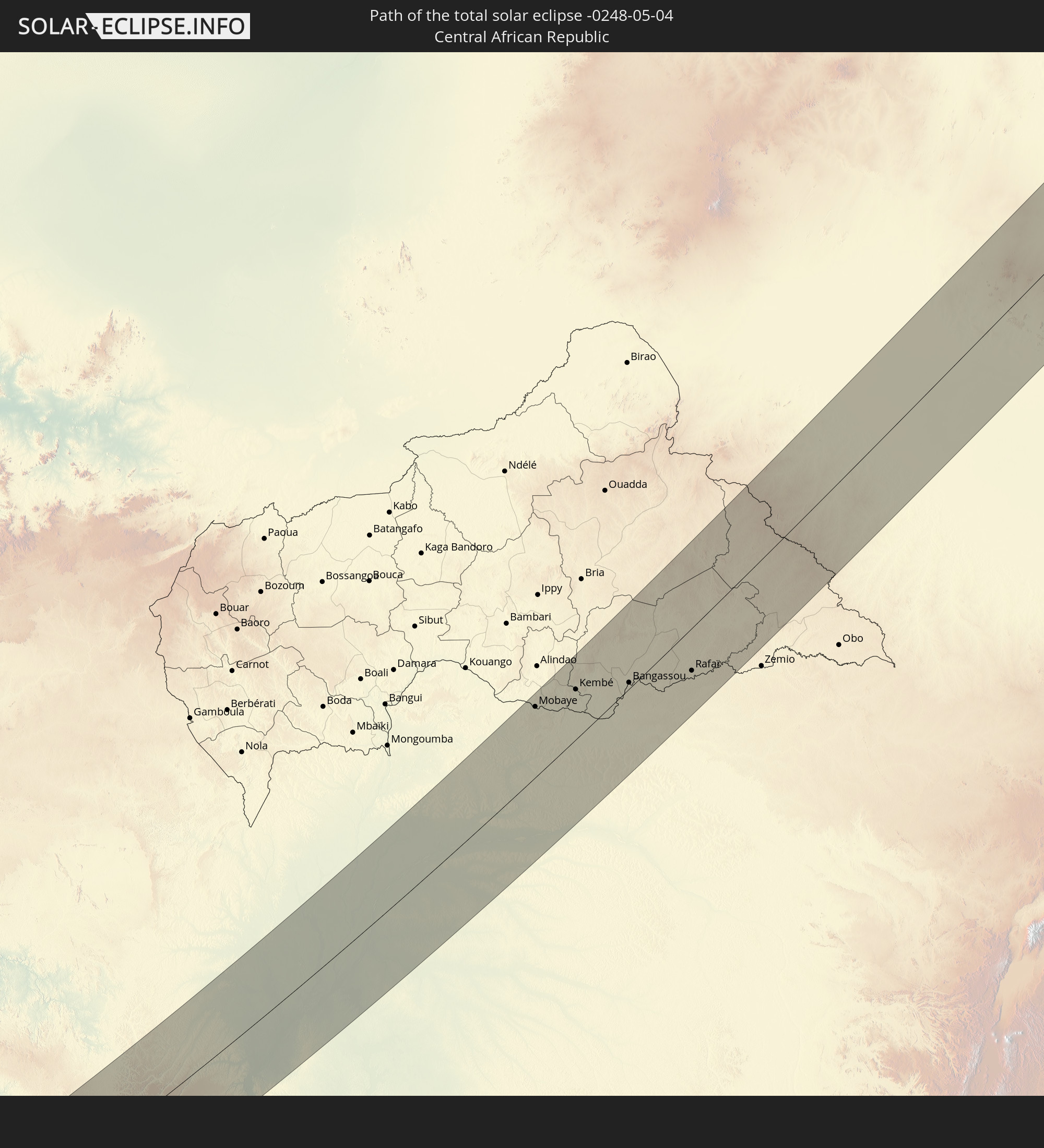 Central African Republic
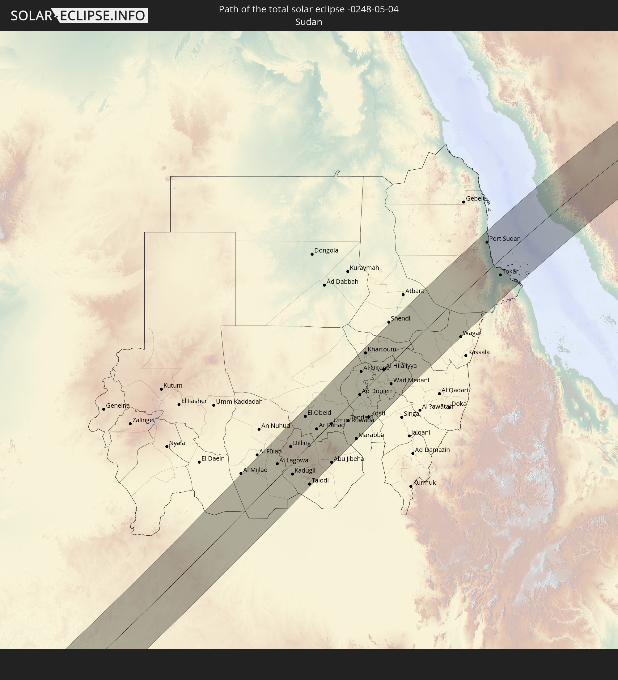 Sudan
Sudan
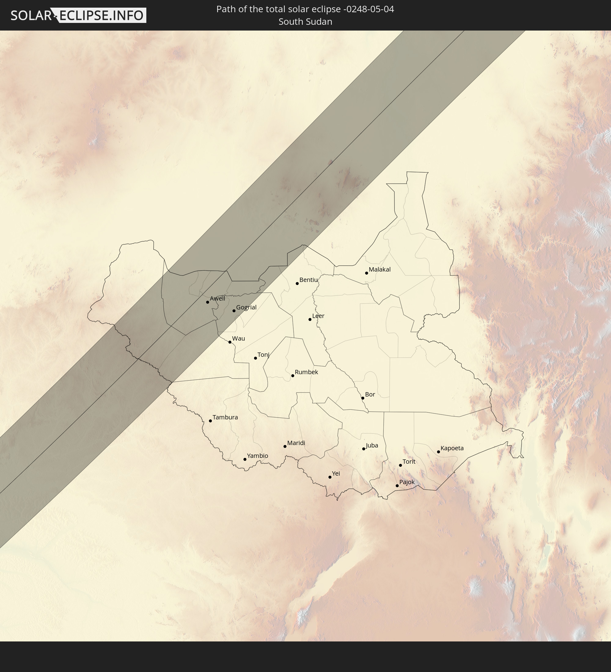 South Sudan
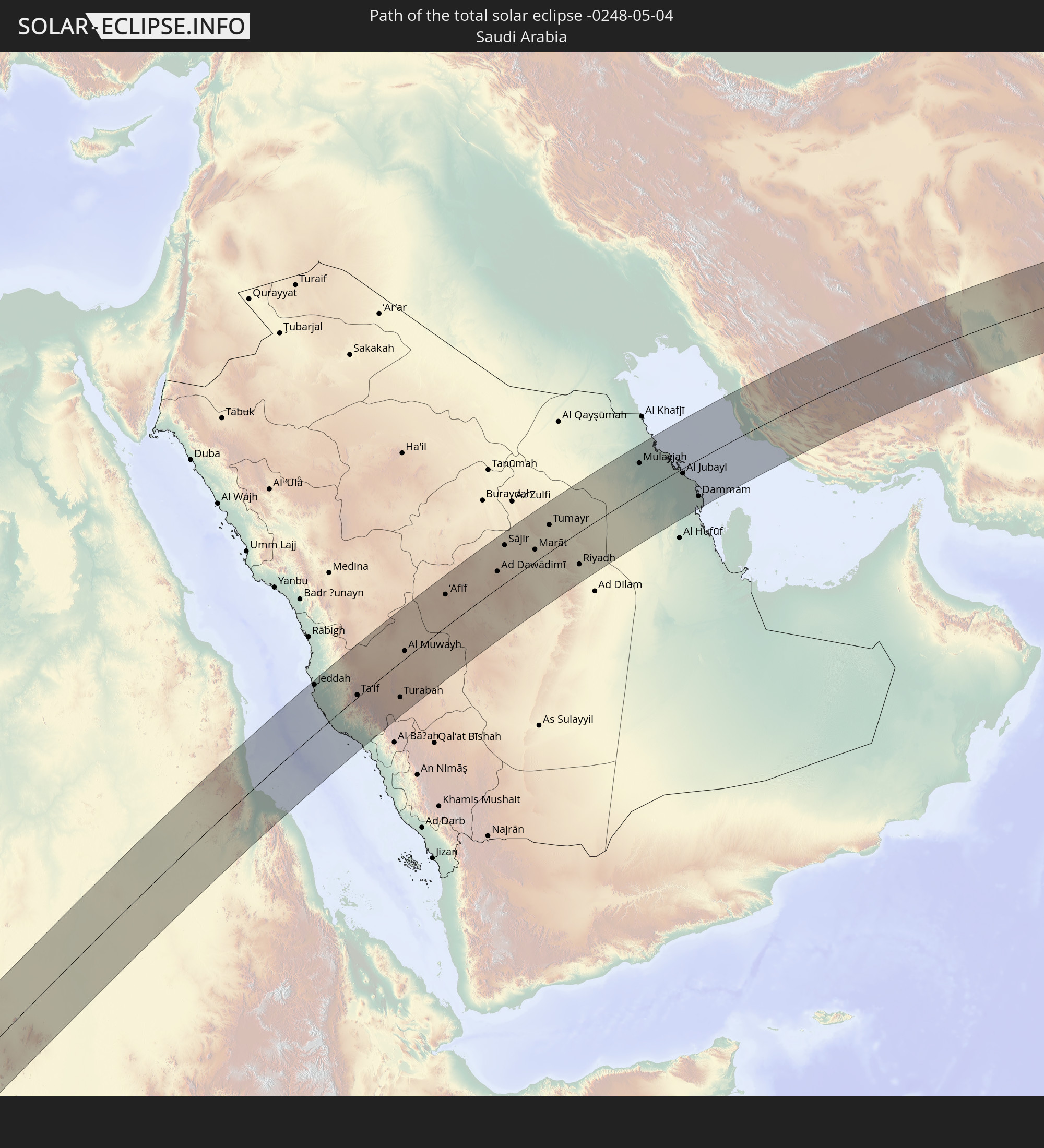 Saudi Arabia
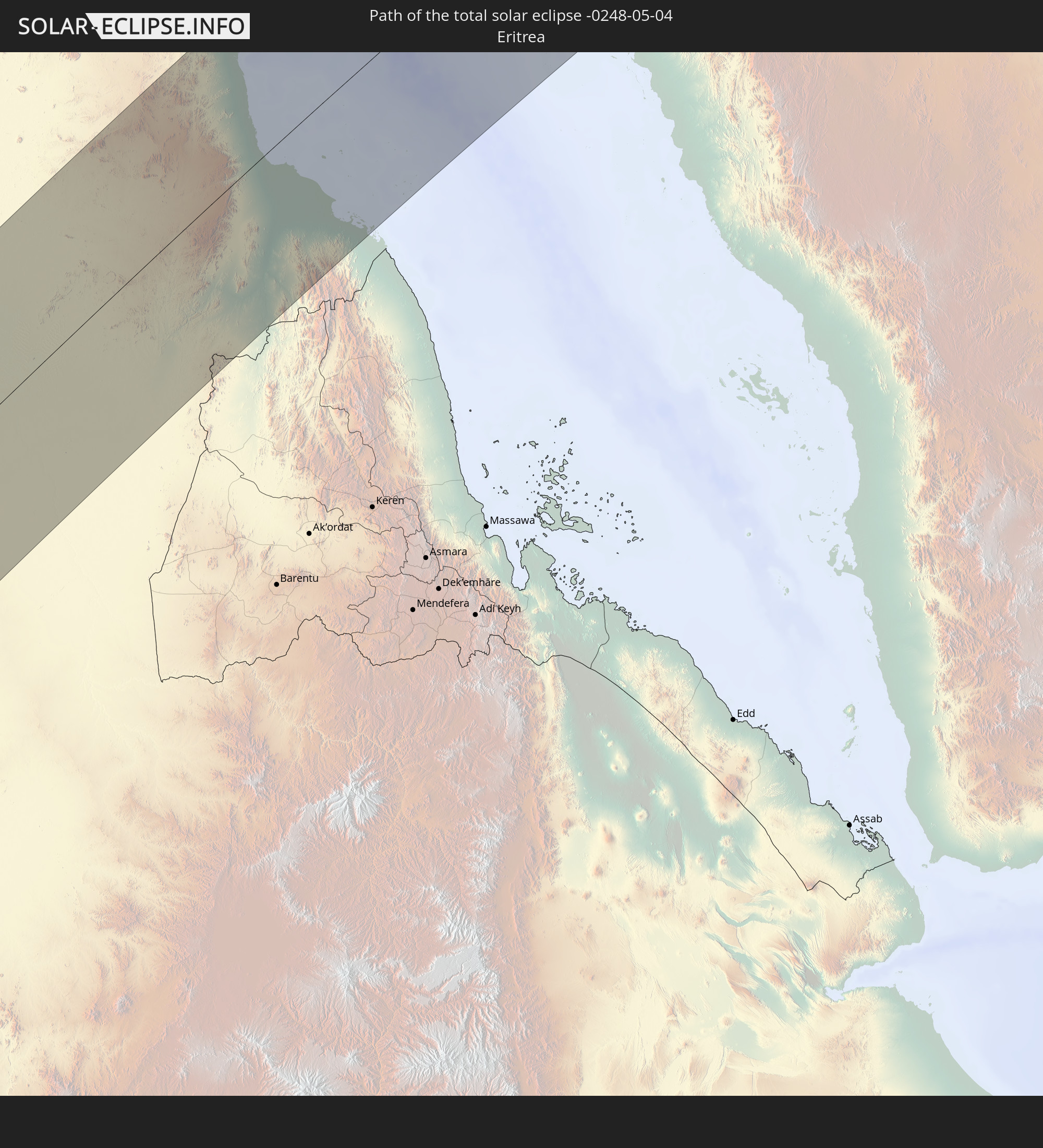 Eritrea
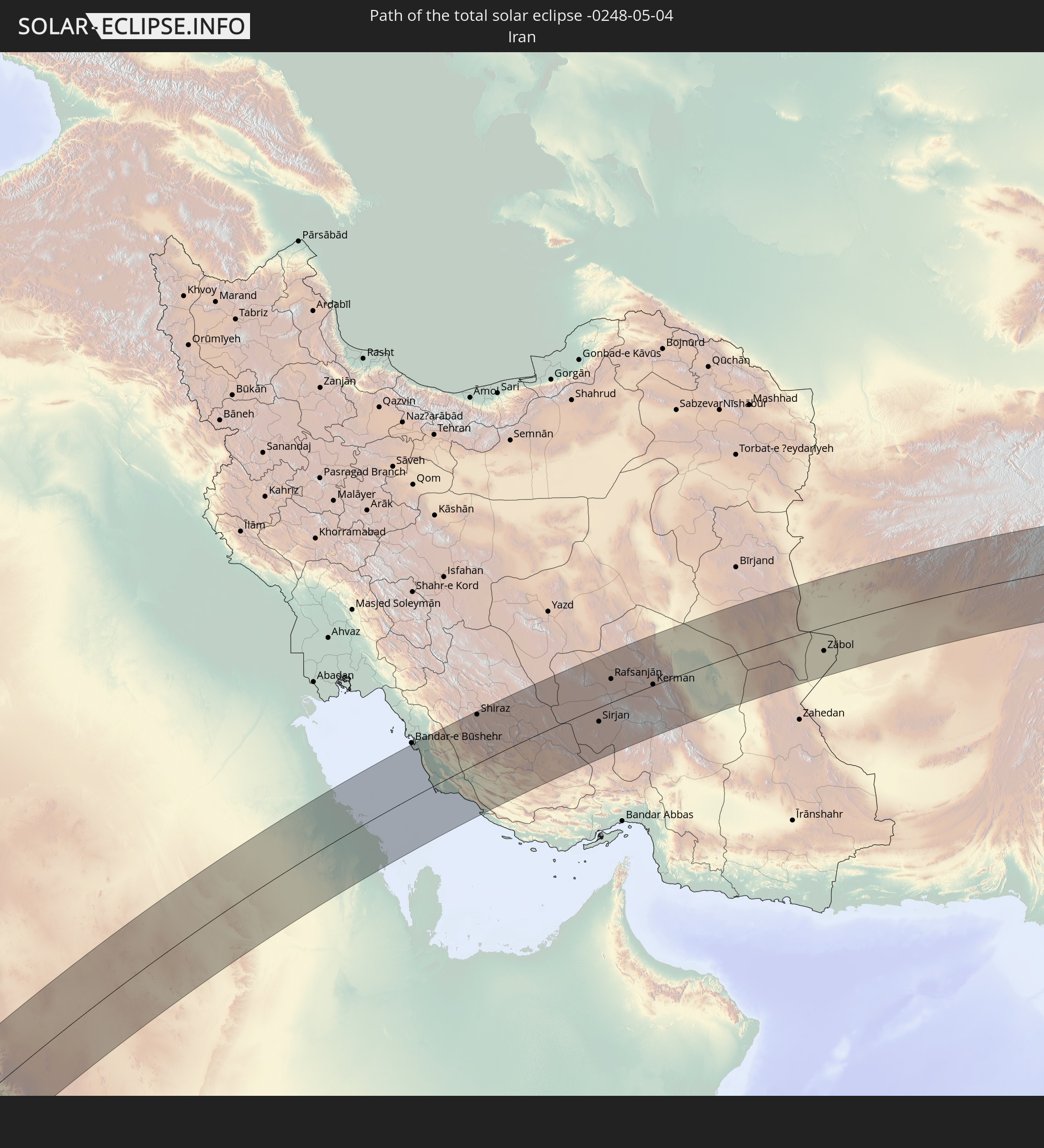 Iran
Iran
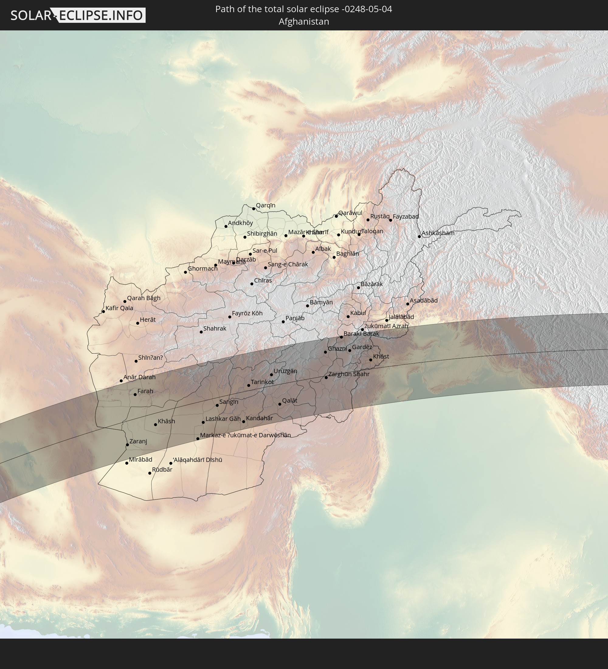 Afghanistan
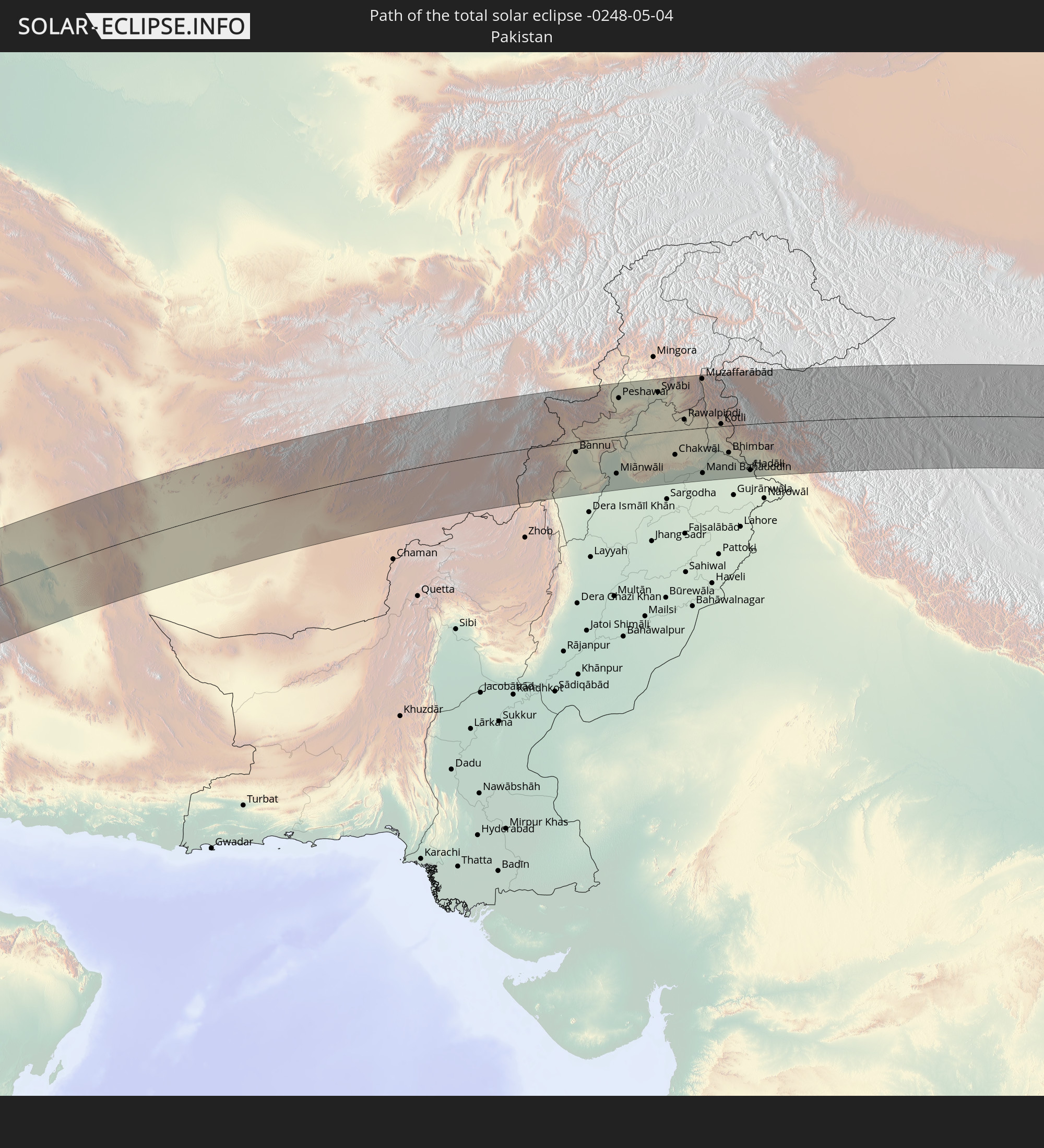 Pakistan
 India
India
 China
China
In den folgenden Ländern ist die Sonnenfinsternis partiell zu sehen
 Russia
 Cabo Verde
 Senegal
 Mauritania
 The Gambia
 Guinea-Bissau
 Guinea
 Saint Helena, Ascension and Tristan da Cunha
 Sierra Leone
 Mali
Mali
 Liberia
 Algeria
 Ivory Coast
 Burkina Faso
 France
 Ghana
Ghana
 Togo
Togo
 Niger
Niger
 Benin
Benin
 Nigeria
 Equatorial Guinea
 São Tomé and Príncipe
 Italy
Italy
 Tunisia
 Cameroon
 Gabon
Gabon
 Libya
Libya
 Austria
 Republic of the Congo
 Angola
 Namibia
 Czechia
 Democratic Republic of the Congo
 San Marino
 Vatican City
 Slovenia
 Chad
Chad
 Croatia
 Poland
 Malta
Malta
 Central African Republic
 Bosnia and Herzegovina
 Hungary
 South Africa
 Slovakia
 Montenegro
 Serbia
 Albania
 Greece
 Botswana
 Romania
 Republic of Macedonia
 Lithuania
 Sudan
Sudan
 Zambia
 Ukraine
 Bulgaria
 Belarus
 Egypt
Egypt
 Zimbabwe
 Turkey
 Moldova
 Lesotho
 Rwanda
 Burundi
 Tanzania
 Uganda
 Mozambique
 Swaziland
 Cyprus
 Malawi
 Ethiopia
 Kenya
Kenya
 State of Palestine
 Israel
 Saudi Arabia
 Jordan
 Lebanon
 Syria
Syria
 Eritrea
 Iraq
Iraq
 Georgia
 French Southern and Antarctic Lands
 Somalia
 Djibouti
 Yemen
Yemen
 Madagascar
 Comoros
 Armenia
 Iran
Iran
 Azerbaijan
 Mayotte
 Seychelles
 Kazakhstan
 Kuwait
 Bahrain
 Qatar
Qatar
 United Arab Emirates
 Oman
Oman
 Turkmenistan
 Uzbekistan
 Afghanistan
 Pakistan
 Tajikistan
 India
India
 Kyrgyzstan
 Maldives
 China
China
 Sri Lanka
 Nepal
Nepal
 Mongolia
 Bangladesh
 Bhutan
 Myanmar
 Indonesia
 Thailand
 Malaysia
 Laos
Laos
 Vietnam
 Cambodia
 Singapore
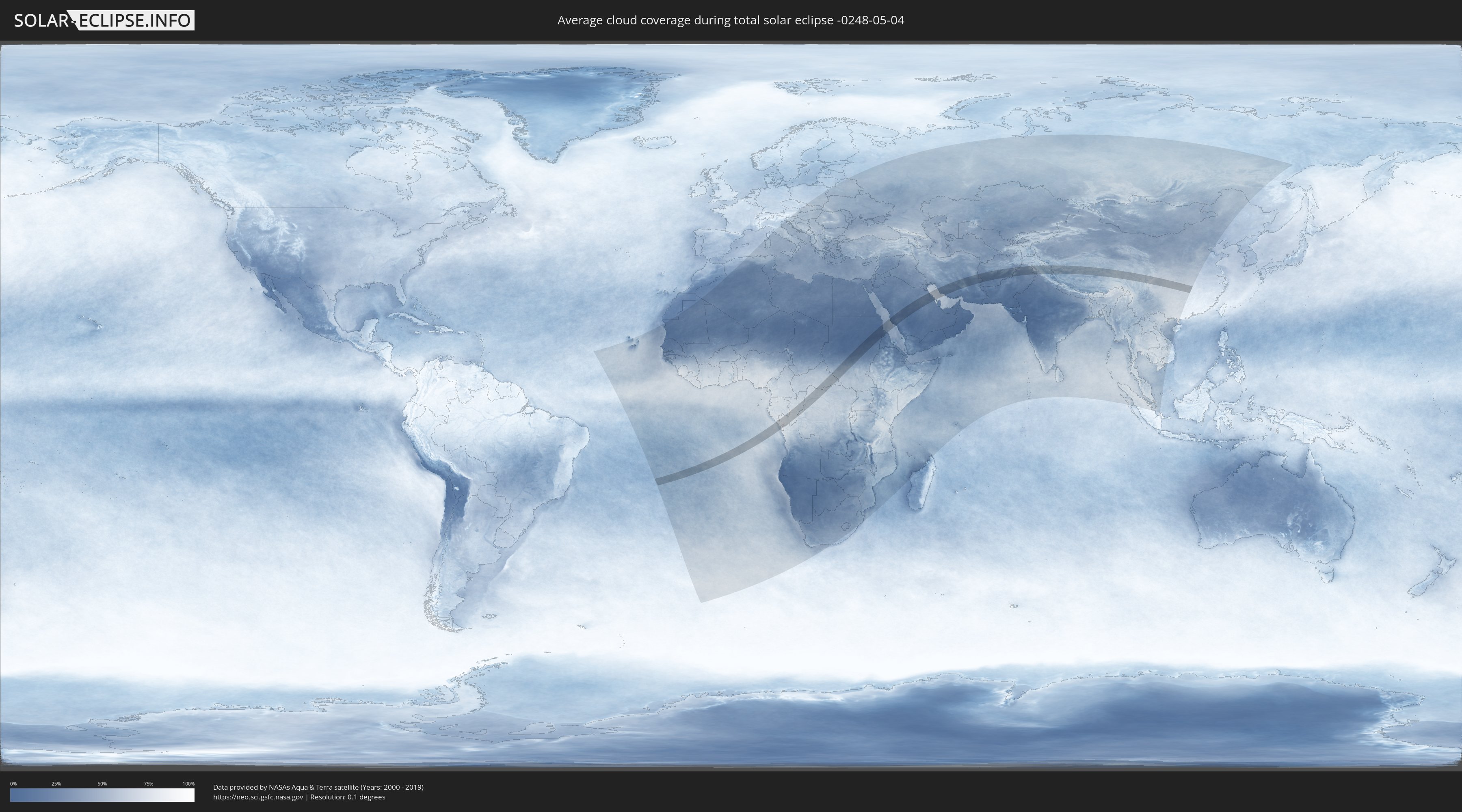
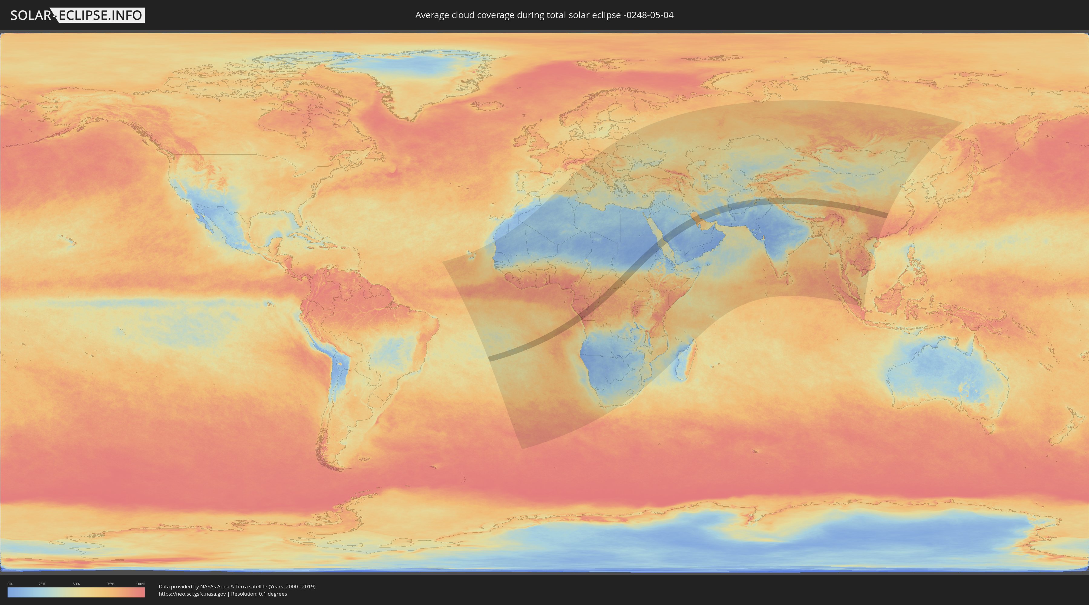
How will be the weather during the total solar eclipse on 05/04/-0248?
Where is the best place to see the total solar eclipse of 05/04/-0248?
The following maps show the average cloud coverage for the day of the total solar eclipse.
With the help of these maps, it is possible to find the place along the eclipse path, which has the best
chance of a cloudless sky.
Nevertheless, you should consider local circumstances and inform about the weather of your chosen
observation site.
The data is provided by NASAs satellites
AQUA and TERRA.
The cloud maps are averaged over a period of 19 years (2000 - 2019).
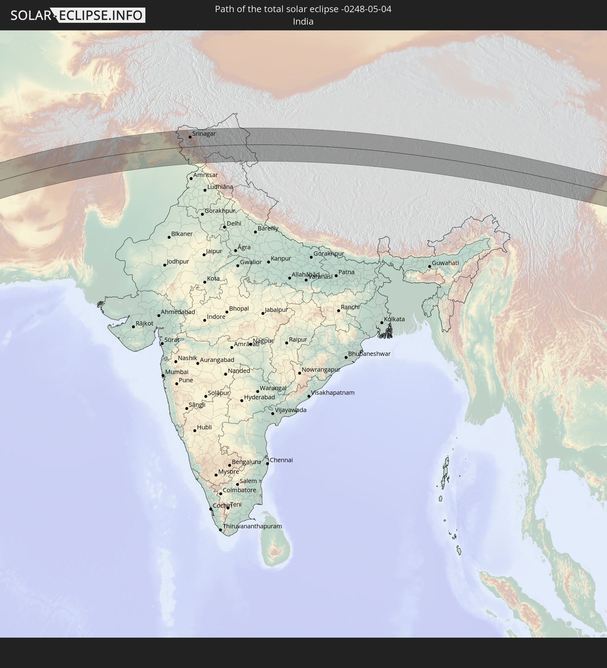
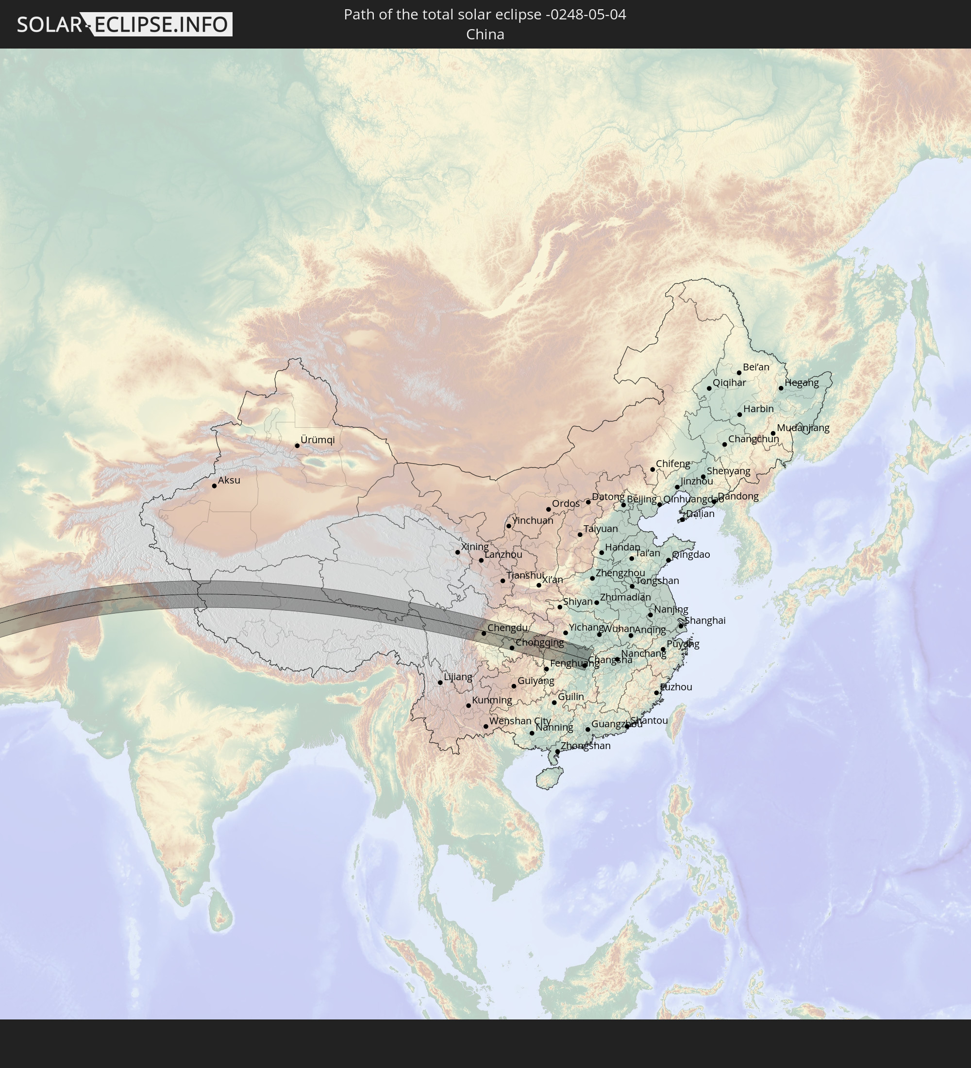
Detailed country maps
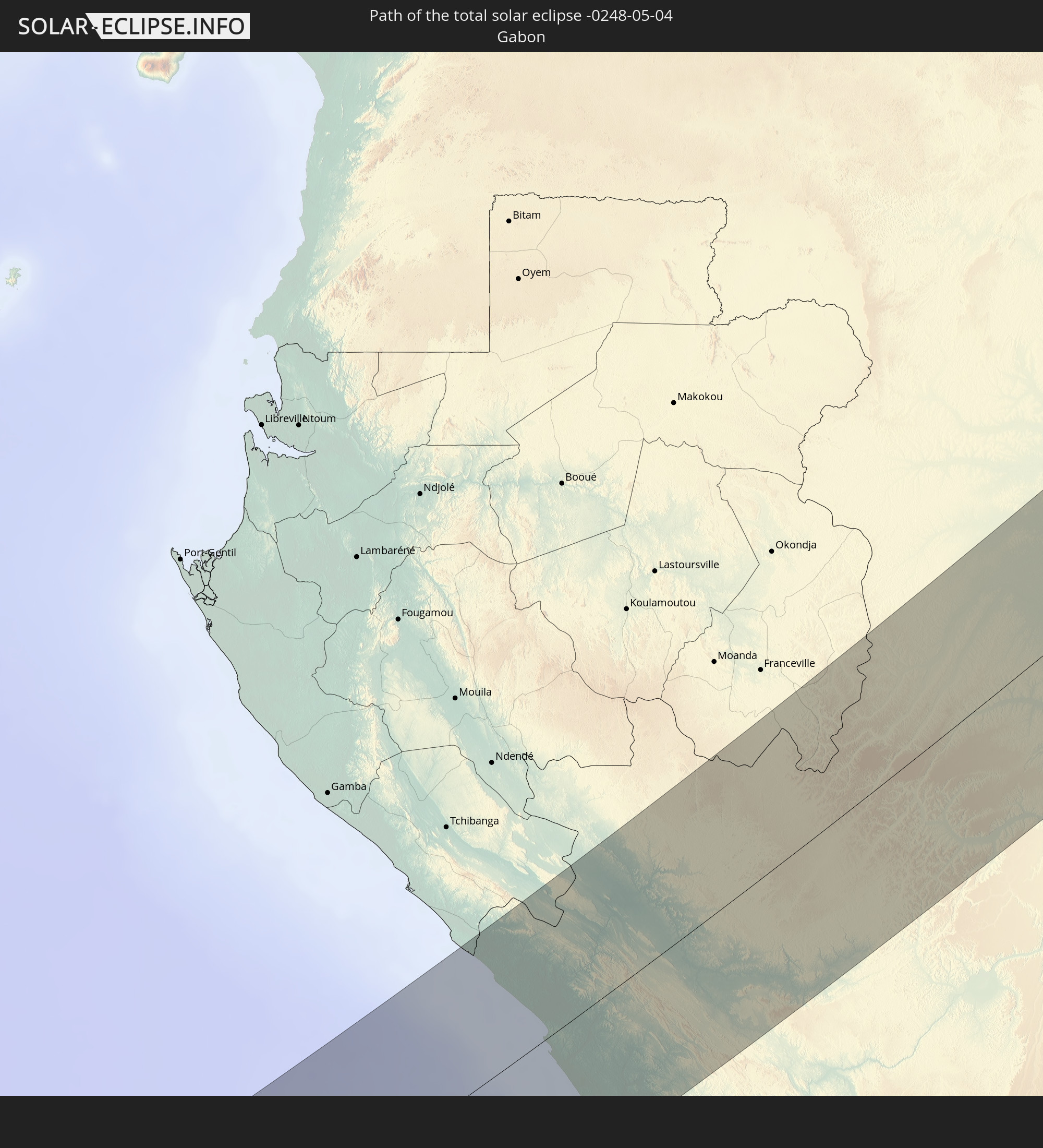
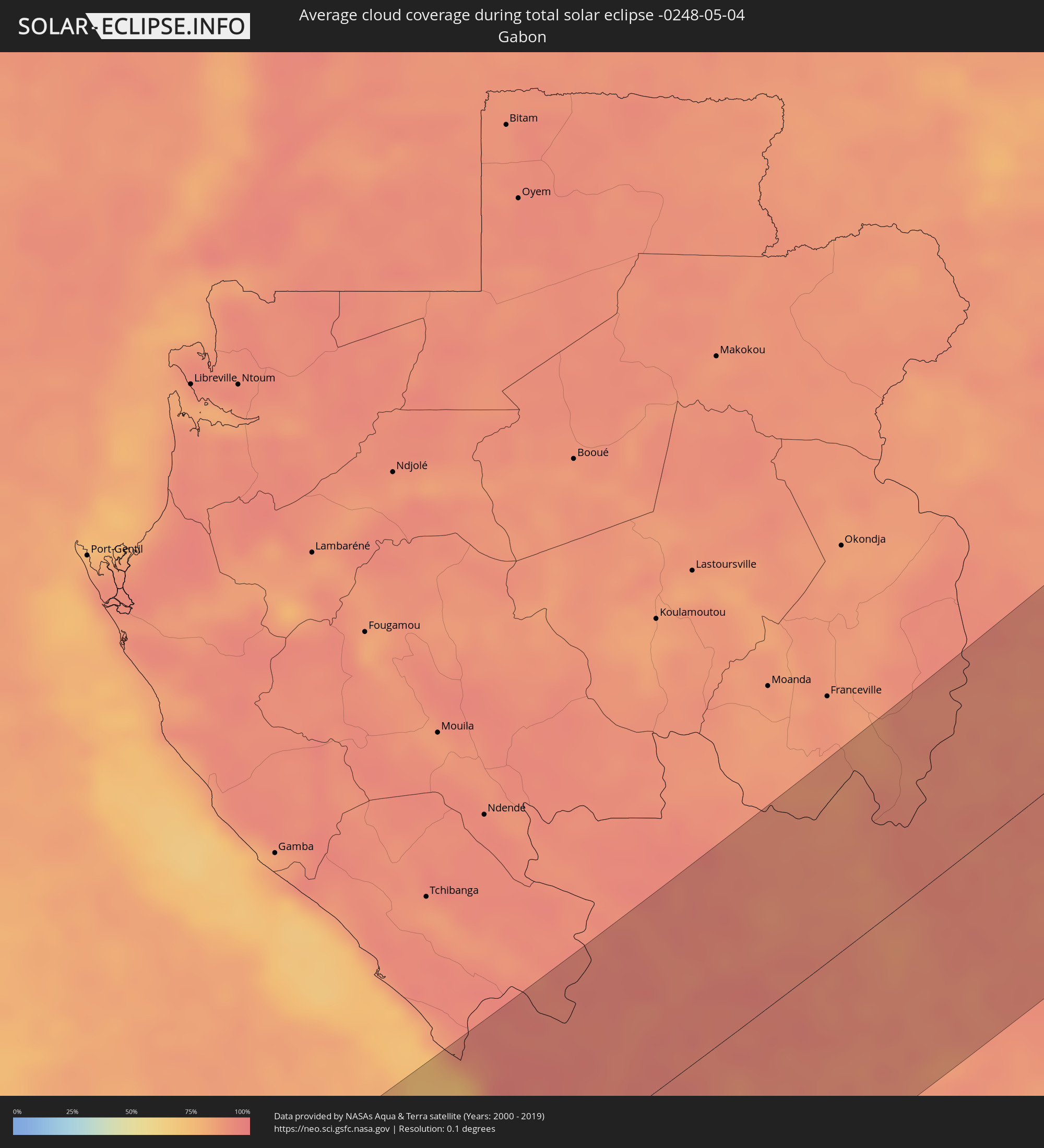 Gabon
Gabon
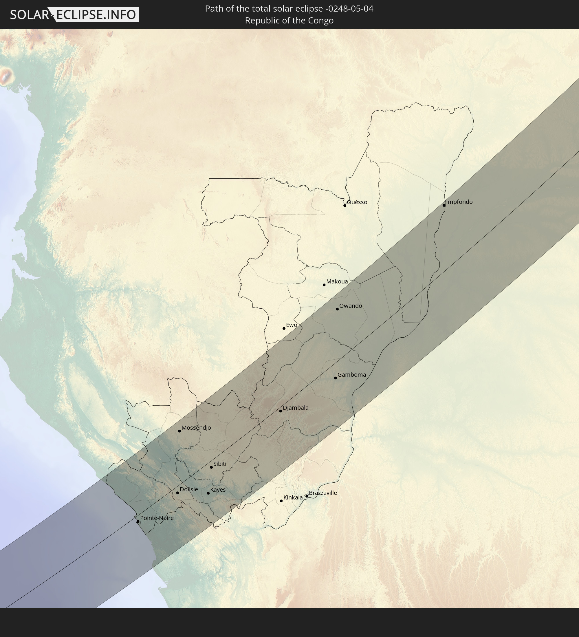
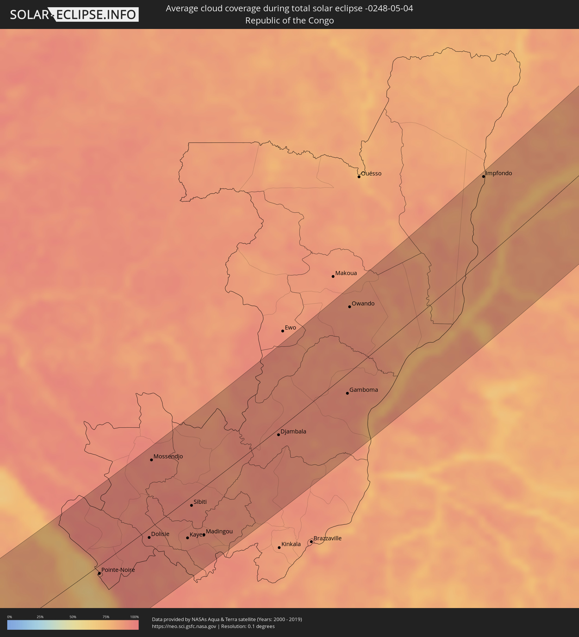 Republic of the Congo
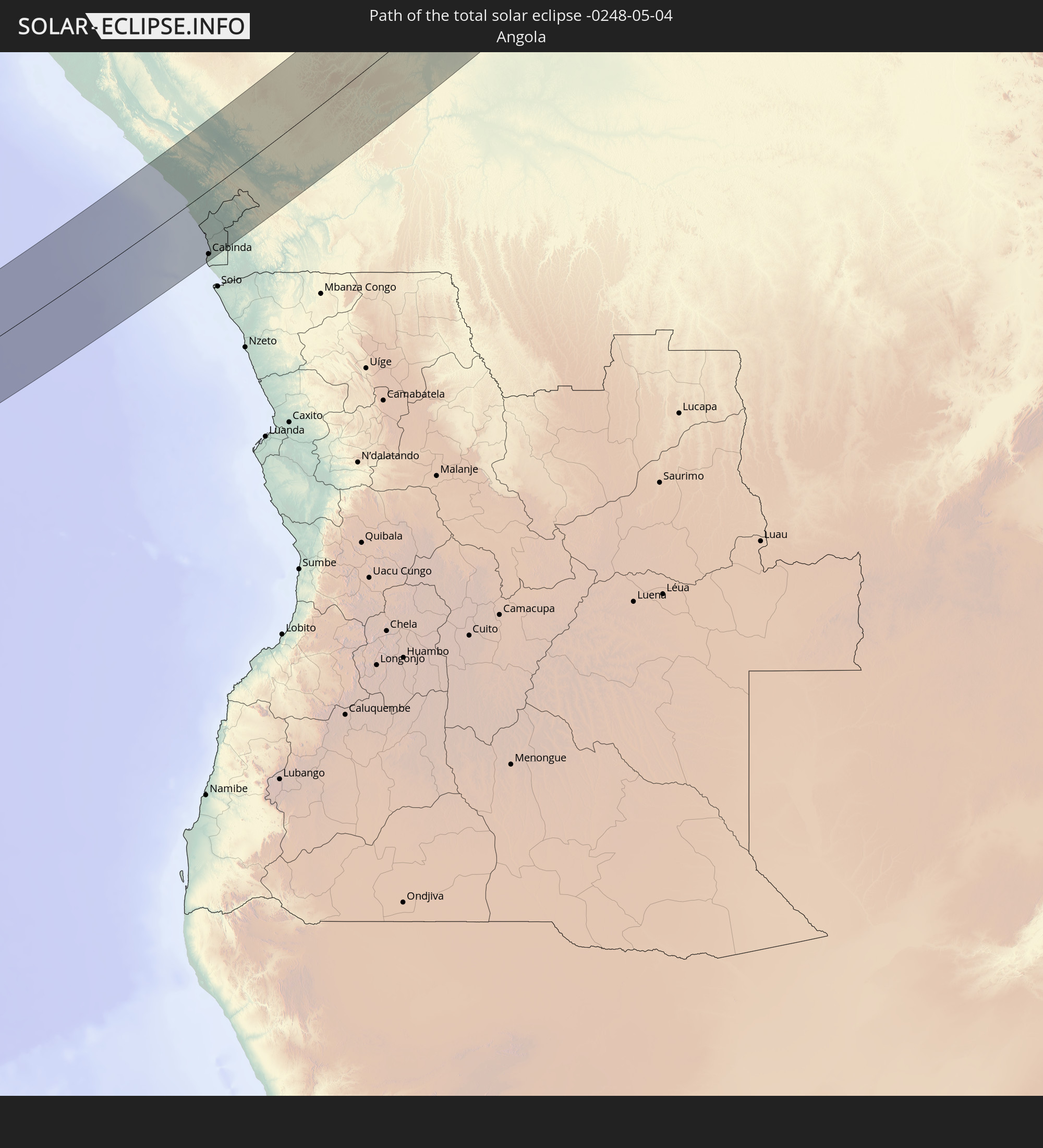
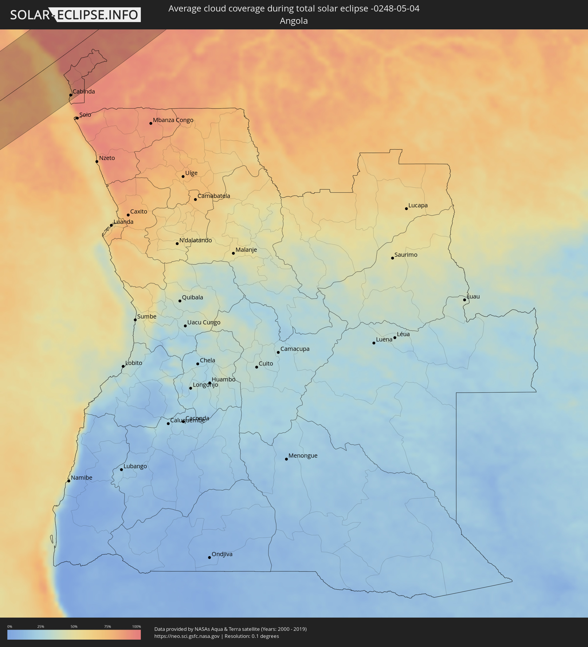 Angola
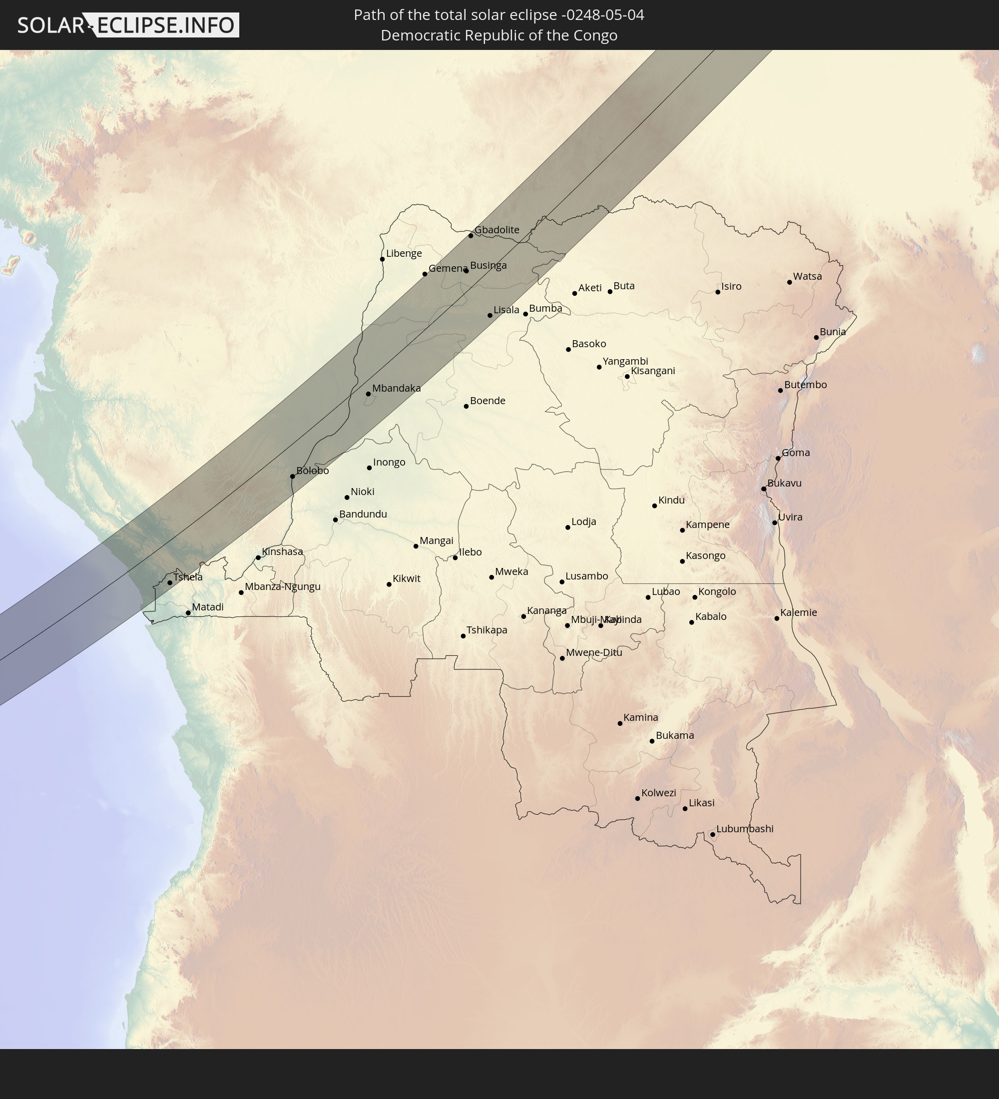
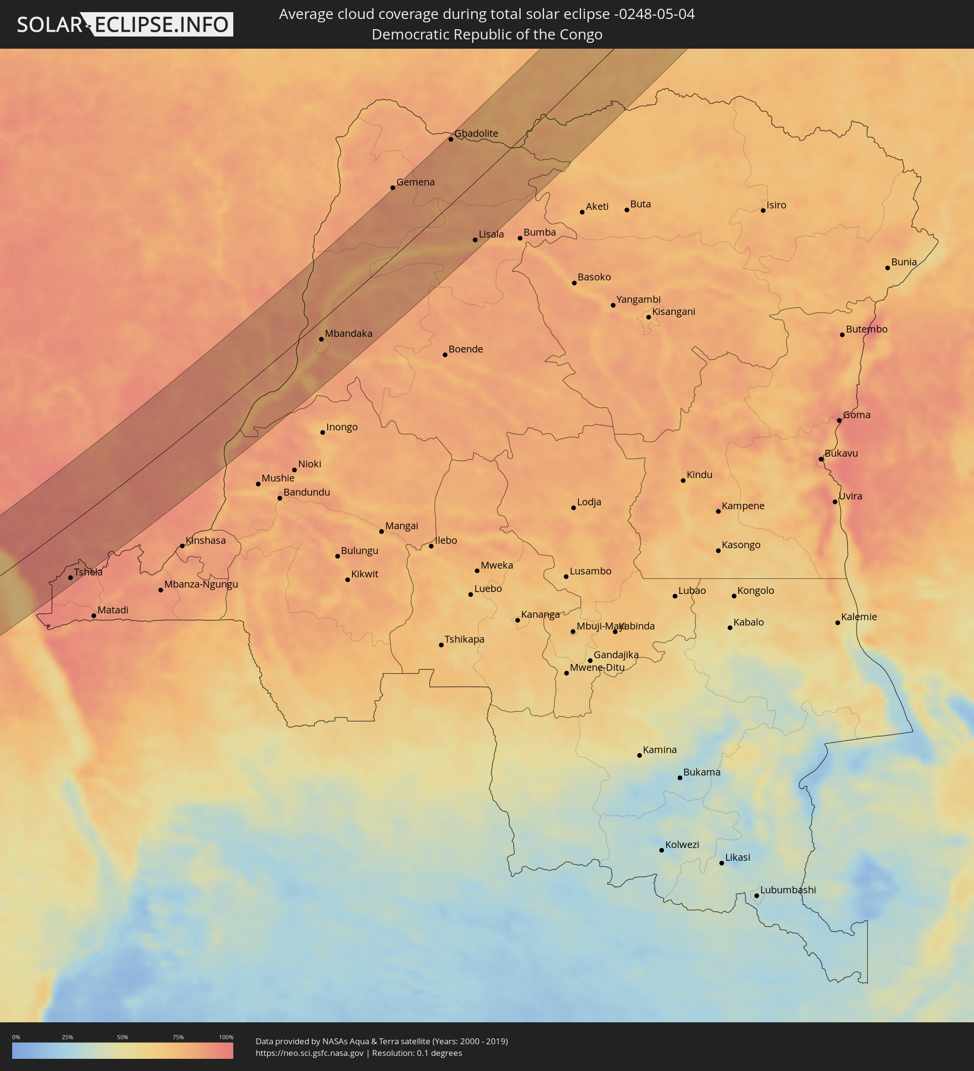 Democratic Republic of the Congo
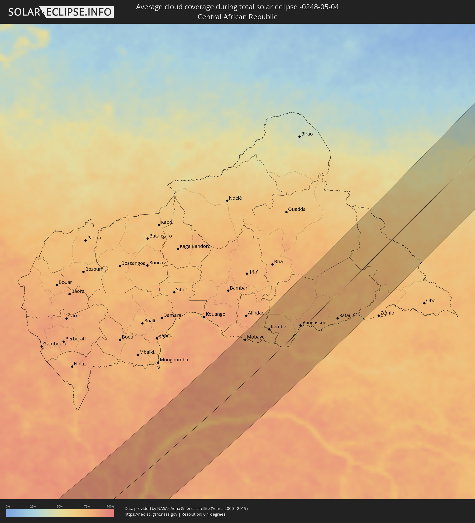 Central African Republic
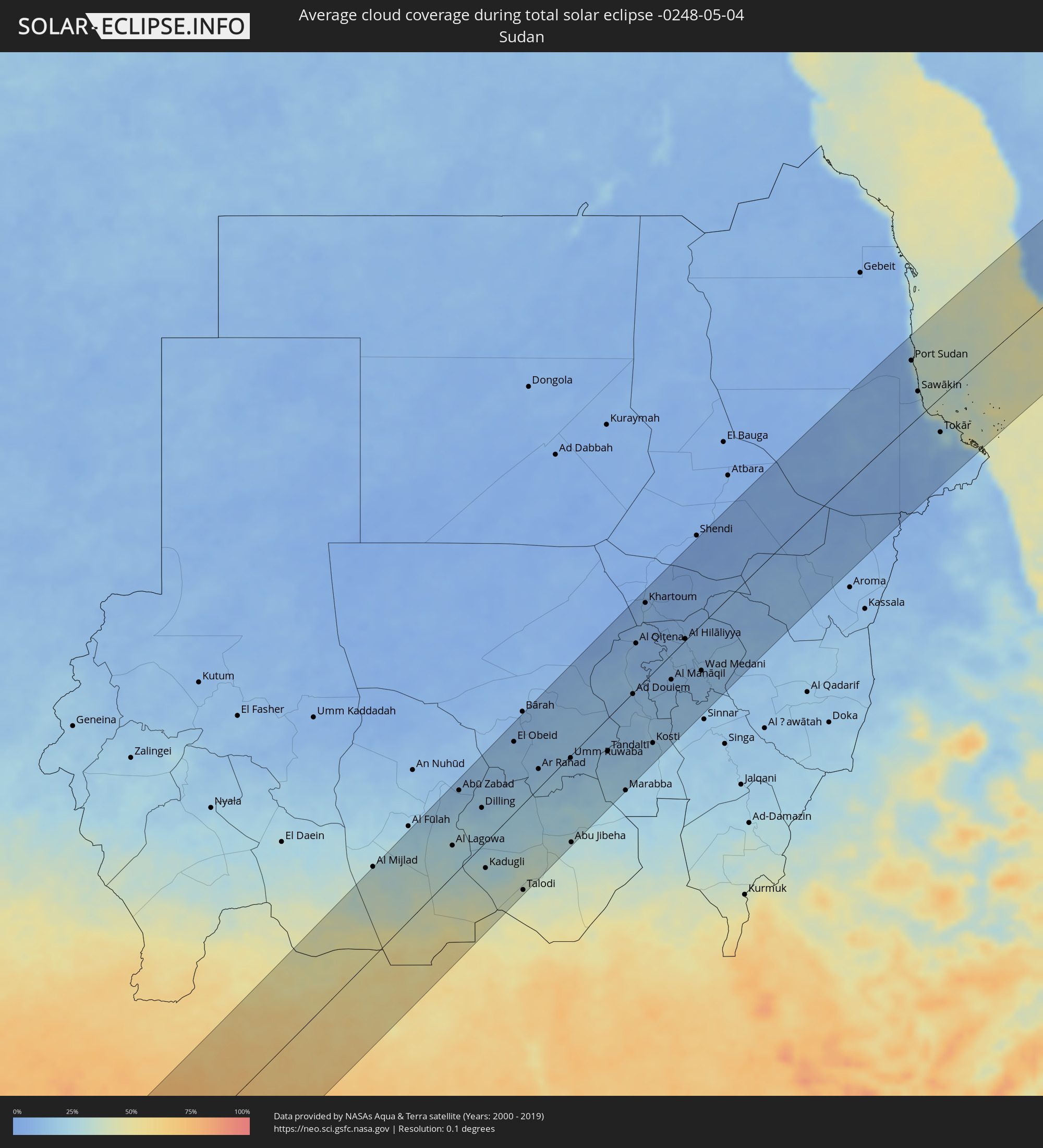 Sudan
Sudan
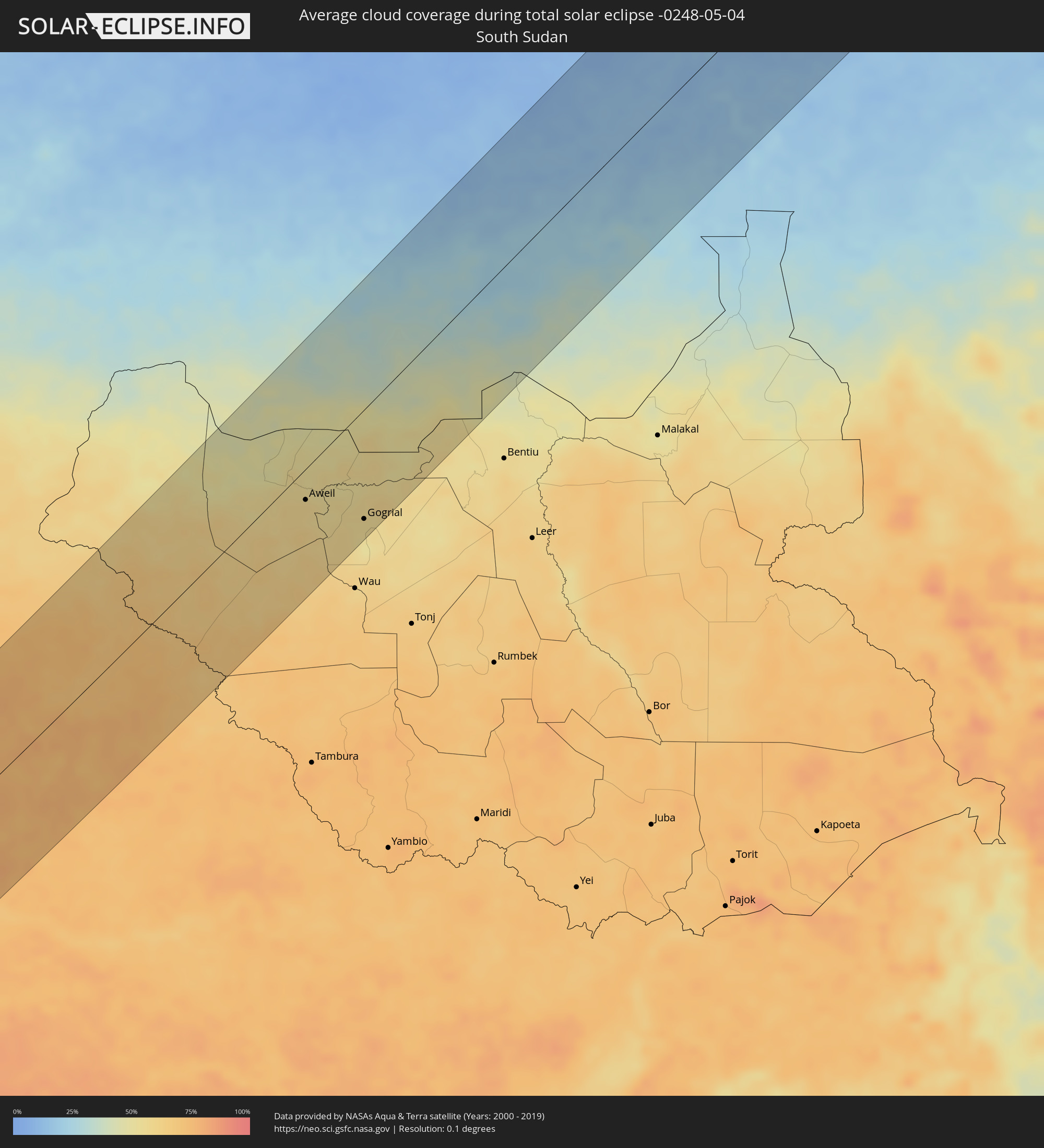 South Sudan
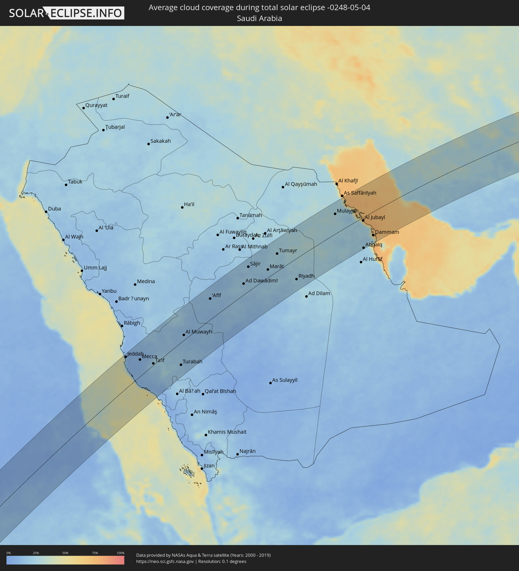 Saudi Arabia
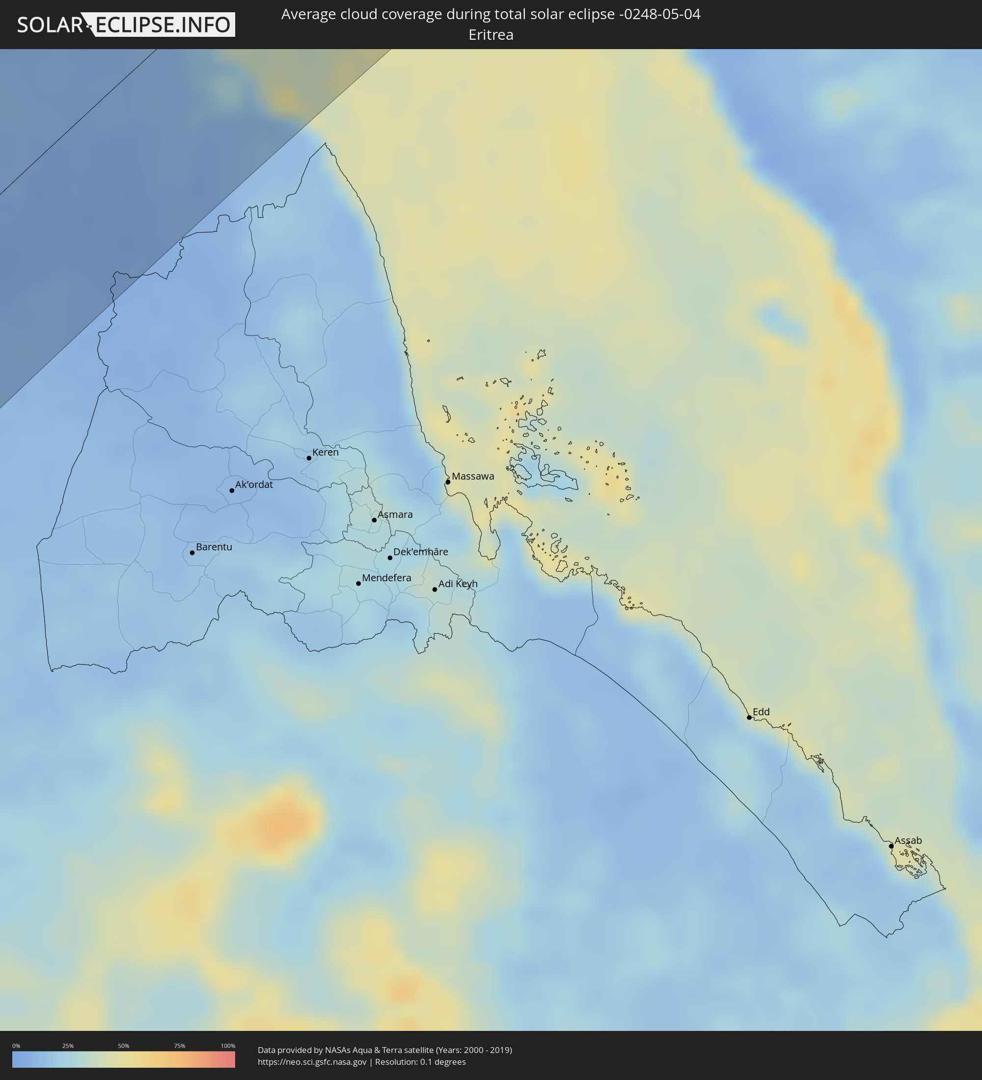 Eritrea
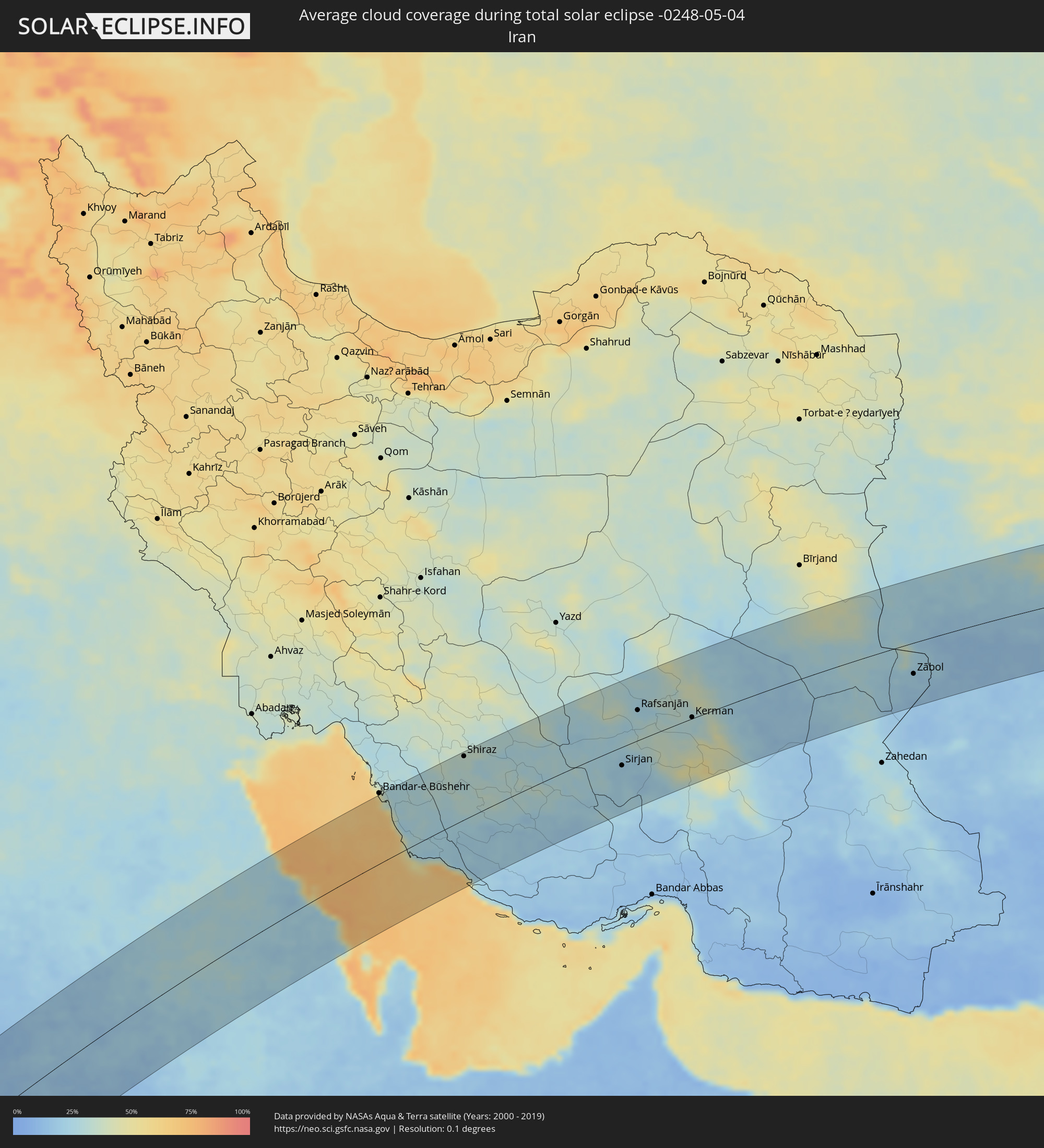 Iran
Iran
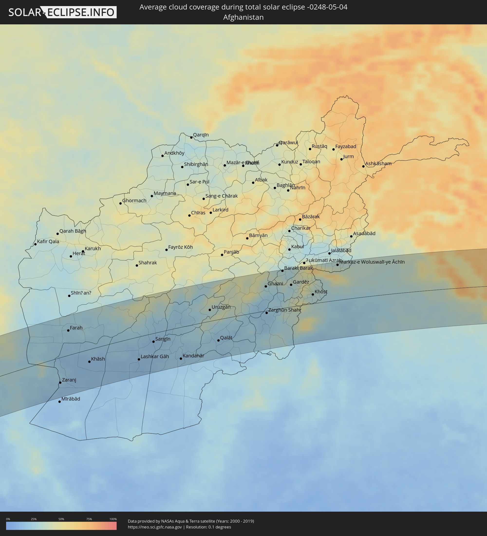 Afghanistan
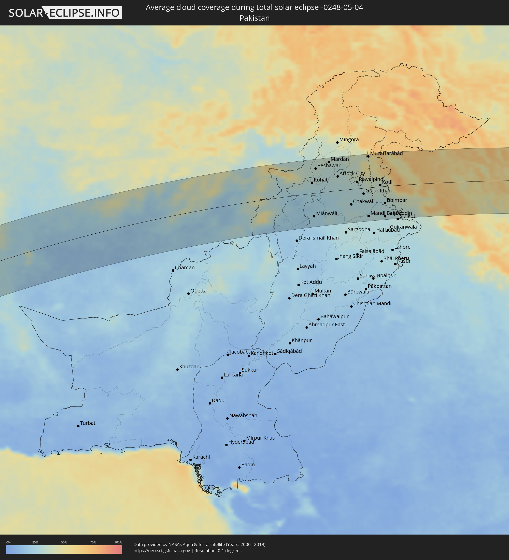 Pakistan
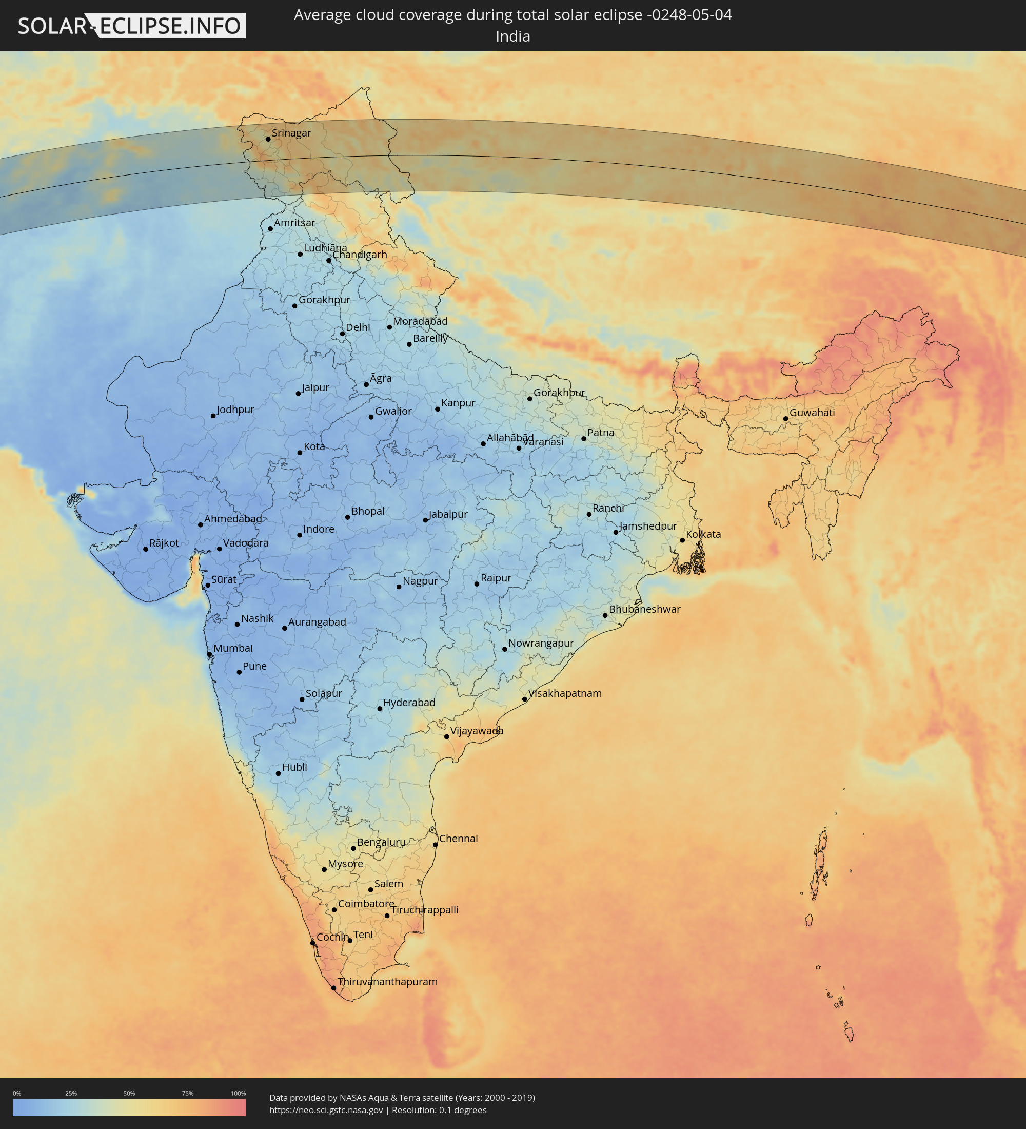 India
India
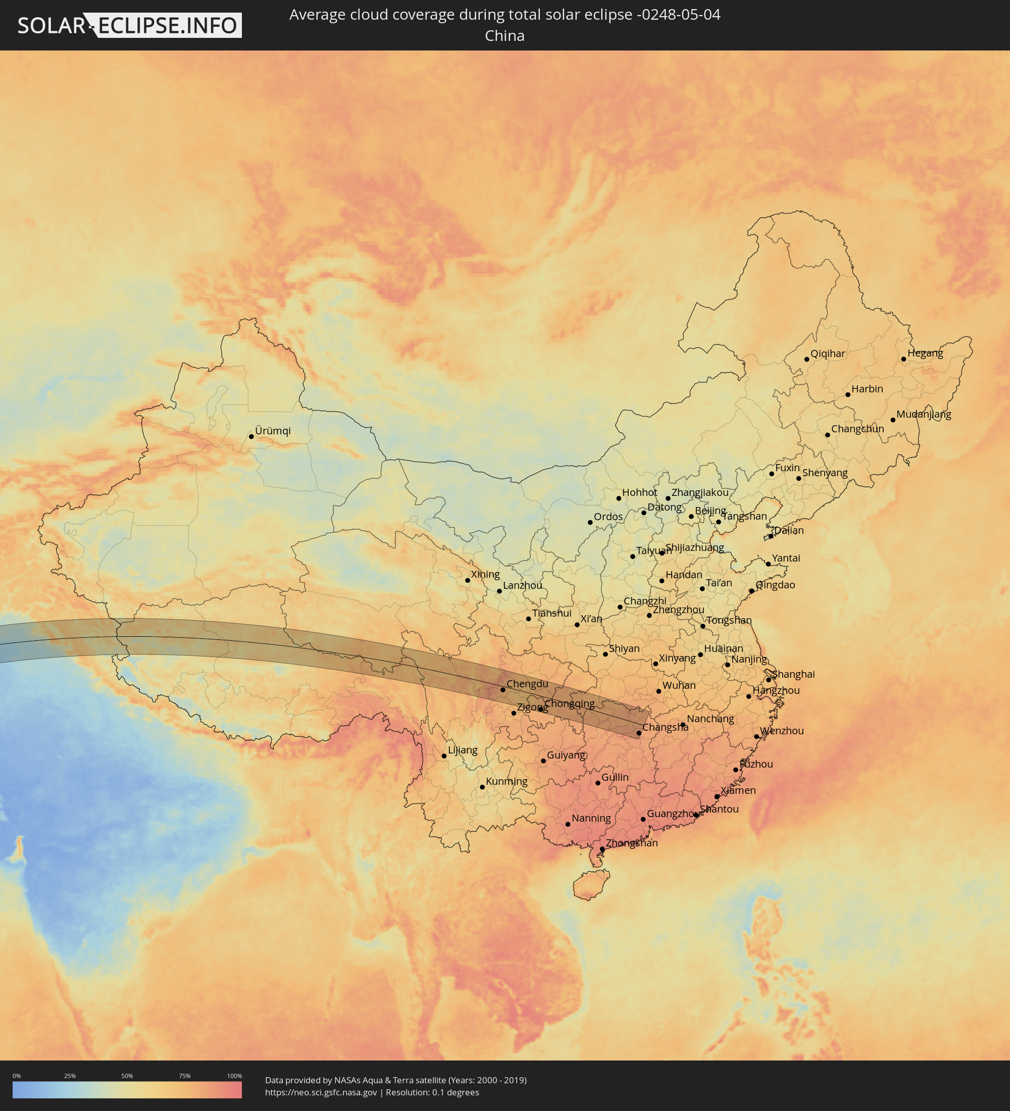 China
China
Cities inside the path of the eclipse
The following table shows all locations with a population of more than 5,000 inside the eclipse path. Cities which have more than 100,000 inhabitants are marked bold. A click at the locations opens a detailed map.
| City | Type | Eclipse duration | Local time of max. eclipse | Distance to central line | Ø Cloud coverage |
|
Loango, Kouilou
|
total | - | 08:03:46 UTC+00:13 | 2 km | 77% |
|
Loandjili, Pointe-Noire
|
total | - | 08:03:41 UTC+00:13 | 10 km | 82% |
|
Pointe-Noire, Pointe-Noire
|
total | - | 08:03:40 UTC+00:13 | 12 km | 82% |
|
Cabinda, Cabinda
|
total | - | 08:03:00 UTC+00:13 | 104 km | 87% |
|
Dolisie, Niari
|
total | - | 08:05:06 UTC+00:13 | 13 km | 93% |
|
Mossendjo, Niari
|
total | - | 08:06:45 UTC+00:13 | 95 km | 93% |
|
Tshela, Bas-Congo
|
total | - | 08:04:21 UTC+00:13 | 103 km | 91% |
|
Kayes, Bouenza
|
total | - | 08:05:40 UTC+00:13 | 55 km | 91% |
|
Sibiti, Lékoumou
|
total | - | 08:06:24 UTC+00:13 | 13 km | 93% |
|
Madingou, Bouenza
|
total | - | 08:05:58 UTC+00:13 | 68 km | 91% |
|
Djambala, Plateaux
|
total | - | 08:09:17 UTC+00:13 | 9 km | 92% |
|
Gamboma, Plateaux
|
total | - | 08:11:21 UTC+00:13 | 28 km | 91% |
|
Owando, Cuvette
|
total | - | 08:13:24 UTC+00:13 | 90 km | 88% |
|
Bolobo, Bandundu
|
total | - | 08:11:20 UTC+00:13 | 78 km | 78% |
|
Lukolela, Équateur
|
total | - | 08:13:56 UTC+00:13 | 51 km | 86% |
|
Impfondo, Likouala
|
total | - | 08:19:00 UTC+00:13 | 111 km | 81% |
|
Mbandaka, Équateur
|
total | - | 08:16:49 UTC+00:13 | 35 km | 83% |
|
Businga, Équateur
|
total | - | 08:25:17 UTC+00:13 | 43 km | 85% |
|
Gbadolite, Équateur
|
total | - | 08:27:01 UTC+00:13 | 110 km | 84% |
|
Mobaye, Basse-Kotto
|
total | - | 08:27:19 UTC+00:13 | 100 km | 81% |
|
Lisala, Équateur
|
total | - | 08:24:08 UTC+00:13 | 102 km | 77% |
|
Kembé, Basse-Kotto
|
total | - | 08:28:47 UTC+00:13 | 71 km | 75% |
|
Bangassou, Mbomou
|
total | - | 08:30:16 UTC+00:13 | 9 km | 76% |
|
Rafaï, Mbomou
|
total | - | 08:32:10 UTC+00:13 | 59 km | 72% |
 Aweil, Northern Bahr al Ghazal
|
total | - | 10:37:14 UTC+02:06 | 29 km | 58% |
|
Kuacjok, Warrap
|
total | - | 10:37:19 UTC+02:06 | 111 km | 54% |
|
Gogrial, Warrap
|
total | - | 10:37:56 UTC+02:06 | 102 km | 55% |
|
Dilling, Southern Kordofan
|
total | - | 10:50:54 UTC+02:10 | 51 km | 18% |
|
Kadugli, Southern Kordofan
|
total | - | 10:49:01 UTC+02:10 | 35 km | 30% |
|
El Obeid, North Kordofan
|
total | - | 10:54:05 UTC+02:10 | 96 km | 14% |
|
Ar Rahad, North Kordofan
|
total | - | 10:53:55 UTC+02:10 | 26 km | 15% |
|
Umm Ruwaba, North Kordofan
|
total | - | 10:55:17 UTC+02:10 | 3 km | 16% |
|
Abu Jibeha, Southern Kordofan
|
total | - | 10:52:29 UTC+02:10 | 118 km | 29% |
|
Tandaltī, White Nile
|
total | - | 10:56:39 UTC+02:10 | 45 km | 16% |
|
Ad Douiem, White Nile
|
total | - | 10:59:22 UTC+02:10 | 2 km | 13% |
|
Khartoum, Khartoum
|
total | - | 11:02:47 UTC+02:10 | 103 km | 10% |
|
Kosti, White Nile
|
total | - | 10:58:22 UTC+02:10 | 95 km | 17% |
|
Al Manāqil, Al Jazīrah
|
total | - | 11:01:05 UTC+02:10 | 34 km | 11% |
|
Kināna, Sinnār
|
total | - | 11:01:00 UTC+02:10 | 65 km | 14% |
|
Al Hasaheisa, Al Jazīrah
|
total | - | 11:02:38 UTC+02:10 | 18 km | 14% |
|
Wad Medani, Al Jazīrah
|
total | - | 11:02:21 UTC+02:10 | 62 km | 12% |
|
Port Sudan, Red Sea
|
total | - | 11:19:24 UTC+02:10 | 86 km | 13% |
|
Sawākin, Red Sea
|
total | - | 11:18:40 UTC+02:10 | 36 km | 9% |
|
Tokār, Red Sea
|
total | - | 11:18:11 UTC+02:10 | 48 km | 16% |
|
Jeddah, Makkah
|
total | - | 12:23:32 UTC+03:06 | 110 km | 20% |
|
Al Jumūm, Makkah
|
total | - | 12:24:40 UTC+03:06 | 83 km | 10% |
|
Mecca, Makkah
|
total | - | 12:24:35 UTC+03:06 | 58 km | 9% |
|
Ash Shafā, Makkah
|
total | - | 12:24:56 UTC+03:06 | 5 km | 18% |
|
Ta’if, Makkah
|
total | - | 12:25:30 UTC+03:06 | 5 km | 24% |
|
Turabah, Makkah
|
total | - | 12:27:53 UTC+03:06 | 80 km | 18% |
|
‘Afīf, Ar Riyāḑ
|
total | - | 12:35:02 UTC+03:06 | 75 km | 14% |
|
Ad Dawādimī, Ar Riyāḑ
|
total | - | 12:38:59 UTC+03:06 | 40 km | 18% |
|
Riyadh, Ar Riyāḑ
|
total | - | 12:44:02 UTC+03:06 | 78 km | 24% |
|
Al Jubayl, Eastern Province
|
total | - | 12:53:14 UTC+03:06 | 13 km | 47% |
|
Abqaiq, Eastern Province
|
total | - | 12:51:53 UTC+03:06 | 117 km | 19% |
|
Umm as Sāhik, Eastern Province
|
total | - | 12:53:18 UTC+03:06 | 60 km | 26% |
|
Şafwá, Eastern Province
|
total | - | 12:53:22 UTC+03:06 | 62 km | 39% |
|
Tārūt, Eastern Province
|
total | - | 12:53:27 UTC+03:06 | 74 km | 39% |
|
Raḩīmah, Eastern Province
|
total | - | 12:53:40 UTC+03:06 | 62 km | 66% |
|
Dammam, Eastern Province
|
total | - | 12:53:24 UTC+03:06 | 90 km | 27% |
|
Khobar, Eastern Province
|
total | - | 12:53:25 UTC+03:06 | 110 km | 44% |
|
Shiraz, Fars
|
total | - | 13:20:43 UTC+03:25 | 110 km | 33% |
|
Fīrūzābād, Fars
|
total | - | 13:20:00 UTC+03:25 | 32 km | 31% |
|
Akbarābād, Fars
|
total | - | 13:20:49 UTC+03:25 | 63 km | 33% |
|
Fasā, Fars
|
total | - | 13:22:11 UTC+03:25 | 4 km | 30% |
|
Neyrīz, Fars
|
total | - | 13:23:45 UTC+03:25 | 6 km | 30% |
|
Dārāb, Fars
|
total | - | 13:23:44 UTC+03:25 | 60 km | 25% |
|
Shahr-e Bābak, Kerman
|
total | - | 13:26:05 UTC+03:25 | 57 km | 28% |
|
Sirjan, Kerman
|
total | - | 13:26:33 UTC+03:25 | 33 km | 21% |
|
Rafsanjān, Kerman
|
total | - | 13:27:58 UTC+03:25 | 54 km | 25% |
|
Shahrak-e Pābedānā, Kerman
|
total | - | 13:29:18 UTC+03:25 | 114 km | 31% |
|
Zarand, Kerman
|
total | - | 13:29:21 UTC+03:25 | 75 km | 33% |
|
Bardsīr, Kerman
|
total | - | 13:28:38 UTC+03:25 | 17 km | 35% |
|
Rāvar, Kerman
|
total | - | 13:30:08 UTC+03:25 | 114 km | 38% |
|
Kerman, Kerman
|
total | - | 13:29:52 UTC+03:25 | 2 km | 29% |
|
Zābol, Sistan and Baluchestan
|
total | - | 13:38:15 UTC+03:25 | 56 km | 21% |
|
Zaranj, Nimroz
|
total | - | 14:13:06 UTC+04:00 | 74 km | 19% |
|
Farah, Farah
|
total | - | 14:14:16 UTC+04:00 | 71 km | 22% |
|
Khāsh, Nimroz
|
total | - | 14:14:58 UTC+04:00 | 37 km | 14% |
|
Lashkar Gāh, Helmand
|
total | - | 14:17:36 UTC+04:00 | 67 km | 14% |
|
Gereshk, Helmand
|
total | - | 14:18:01 UTC+04:00 | 47 km | 16% |
|
Sangīn, Helmand
|
total | - | 14:18:32 UTC+04:00 | 25 km | 16% |
|
Kandahār, Kandahar
|
total | - | 14:19:45 UTC+04:00 | 93 km | 19% |
|
Tarinkot, Oruzgan
|
total | - | 14:20:21 UTC+04:00 | 14 km | 22% |
|
Uruzgān, Oruzgan
|
total | - | 14:21:35 UTC+04:00 | 32 km | 31% |
|
Qalāt, Zabul
|
total | - | 14:21:47 UTC+04:00 | 62 km | 20% |
|
Ghazni, Ghazni
|
total | - | 14:24:20 UTC+04:00 | 71 km | 29% |
|
Zarghūn Shahr, Paktika
|
total | - | 14:24:15 UTC+04:00 | 7 km | 18% |
|
Barakī Barak, Logar
|
total | - | 14:25:09 UTC+04:00 | 109 km | 31% |
|
Pul-e ‘Alam, Logar
|
total | - | 14:25:15 UTC+04:00 | 111 km | 29% |
|
Gardēz, Paktia
|
total | - | 14:25:29 UTC+04:00 | 64 km | 28% |
|
Khōst, Khowst
|
total | - | 14:26:25 UTC+04:00 | 26 km | 30% |
|
Markaz-e Woluswalī-ye Āchīn, Nangarhar
|
total | - | 14:27:33 UTC+04:00 | 103 km | 37% |
|
Kohāt, Khyber Pakhtunkhwa
|
total | - | 14:56:42 UTC+04:28 | 34 km | 29% |
|
Miānwāli, Punjab
|
total | - | 14:56:43 UTC+04:28 | 78 km | 24% |
|
Peshawar, Khyber Pakhtunkhwa
|
total | - | 14:56:53 UTC+04:28 | 80 km | 33% |
|
Chārsadda, Khyber Pakhtunkhwa
|
total | - | 14:57:06 UTC+04:28 | 94 km | 33% |
|
Nowshera Cantonment, Khyber Pakhtunkhwa
|
total | - | 14:57:26 UTC+04:28 | 75 km | 30% |
|
Mardan, Khyber Pakhtunkhwa
|
total | - | 14:57:30 UTC+04:28 | 97 km | 32% |
|
Attock City, Punjab
|
total | - | 14:57:54 UTC+04:28 | 46 km | 30% |
|
Swābi, Khyber Pakhtunkhwa
|
total | - | 14:58:02 UTC+04:28 | 84 km | 31% |
|
Chakwāl, Punjab
|
total | - | 14:58:30 UTC+04:28 | 51 km | 29% |
|
Rawalpindi, Punjab
|
total | - | 14:58:47 UTC+04:28 | 21 km | 31% |
|
Abbottābād, Khyber Pakhtunkhwa
|
total | - | 14:58:58 UTC+04:28 | 80 km | 40% |
|
Muzaffarābād, Azad Kashmir
|
total | - | 14:59:17 UTC+04:28 | 103 km | 43% |
|
Mandi Bahāuddīn, Punjab
|
total | - | 14:59:17 UTC+04:28 | 96 km | 28% |
|
Jhelum, Punjab
|
total | - | 14:59:36 UTC+04:28 | 59 km | 28% |
|
Kotli, Azad Kashmir
|
total | - | 14:59:50 UTC+04:28 | 5 km | 34% |
|
Bhimbar, Azad Kashmir
|
total | - | 15:00:03 UTC+04:28 | 57 km | 30% |
|
Gujrāt, Punjab
|
total | - | 15:00:03 UTC+04:28 | 101 km | 28% |
|
Pūnch, Kashmir
|
total | - | 15:53:01 UTC+05:21 | 31 km | 40% |
|
Rajaori, Kashmir
|
total | - | 15:53:18 UTC+05:21 | 14 km | 39% |
|
Bāramūla, Kashmir
|
total | - | 15:53:18 UTC+05:21 | 78 km | 59% |
|
Pattan, Kashmir
|
total | - | 15:53:34 UTC+05:21 | 72 km | 47% |
|
Bandipura, Kashmir
|
total | - | 15:53:39 UTC+05:21 | 100 km | 47% |
|
Gāndarbal, Kashmir
|
total | - | 15:53:49 UTC+05:21 | 77 km | 49% |
|
Srinagar, Kashmir
|
total | - | 15:53:52 UTC+05:21 | 62 km | 49% |
|
Jammu, Kashmir
|
total | - | 15:53:59 UTC+05:21 | 89 km | 33% |
|
Pulwama, Kashmir
|
total | - | 15:53:59 UTC+05:21 | 38 km | 51% |
|
Kulgam, Kashmir
|
total | - | 15:54:08 UTC+05:21 | 11 km | 62% |
|
Sāmba, Kashmir
|
total | - | 15:54:18 UTC+05:21 | 109 km | 32% |
|
Udhampur, Kashmir
|
total | - | 15:54:19 UTC+05:21 | 69 km | 32% |
|
Anantnag, Kashmir
|
total | - | 15:54:18 UTC+05:21 | 20 km | 50% |
|
Doda, Kashmir
|
total | - | 15:54:47 UTC+05:21 | 47 km | 51% |
|
Kishtwār, Kashmir
|
total | - | 15:55:02 UTC+05:21 | 30 km | 53% |
|
Padam, Kashmir
|
total | - | 15:56:19 UTC+05:21 | 17 km | 46% |
|
Leh, Kashmir
|
total | - | 15:57:00 UTC+05:21 | 58 km | 47% |
|
Chengdu, Sichuan
|
total | - | 18:53:11 UTC+08:00 | 24 km | 78% |
|
Deyang, Sichuan
|
total | - | 18:53:03 UTC+08:00 | 33 km | 74% |
|
Yanjiang, Sichuan
|
total | - | 18:53:30 UTC+08:00 | 70 km | 74% |
|
Mianyang, Sichuan
|
total | - | 18:52:58 UTC+08:00 | 76 km | 77% |
|
Suining, Sichuan
|
total | - | 18:53:28 UTC+08:00 | 6 km | 72% |
|
Nanchong, Sichuan
|
total | - | 18:53:25 UTC+08:00 | 37 km | 75% |
|
Hechuan, Chongqing
|
total | - | 18:53:45 UTC+08:00 | 45 km | 77% |
|
Beibei, Chongqing
|
total | - | 18:53:50 UTC+08:00 | 59 km | 79% |
|
Chongqing, Chongqing
|
total | - | 18:53:56 UTC+08:00 | 84 km | 79% |
|
Fuling, Chongqing
|
total | - | 18:53:57 UTC+08:00 | 48 km | 77% |
|
Wanxian, Chongqing
|
total | - | 18:53:35 UTC+08:00 | 96 km | 76% |
|
Enshi, Hubei
|
total | - | 18:53:48 UTC+08:00 | 69 km | 74% |
|
Changde, Hunan
|
total | - | 18:54:14 UTC+08:00 | 6 km | 80% |
|
Yiyang, Hunan
|
total | - | 18:54:21 UTC+08:00 | 36 km | 85% |
|
Xiulin, Hubei
|
total | - | 18:53:57 UTC+08:00 | 86 km | 82% |
|
Changsha, Hunan
|
total | - | 18:54:26 UTC+08:00 | 60 km | 85% |
|
Yueyang, Hunan
|
total | - | 18:54:01 UTC+08:00 | 70 km | 81% |