Total solar eclipse of 11/03/-0509
| Day of week: | Sunday |
| Maximum duration of eclipse: | 02m29s |
| Maximum width of eclipse path: | 94 km |
| Saros cycle: | 54 |
| Coverage: | 100% |
| Magnitude: | 1.0275 |
| Gamma: | 0.1217 |
Wo kann man die Sonnenfinsternis vom 11/03/-0509 sehen?
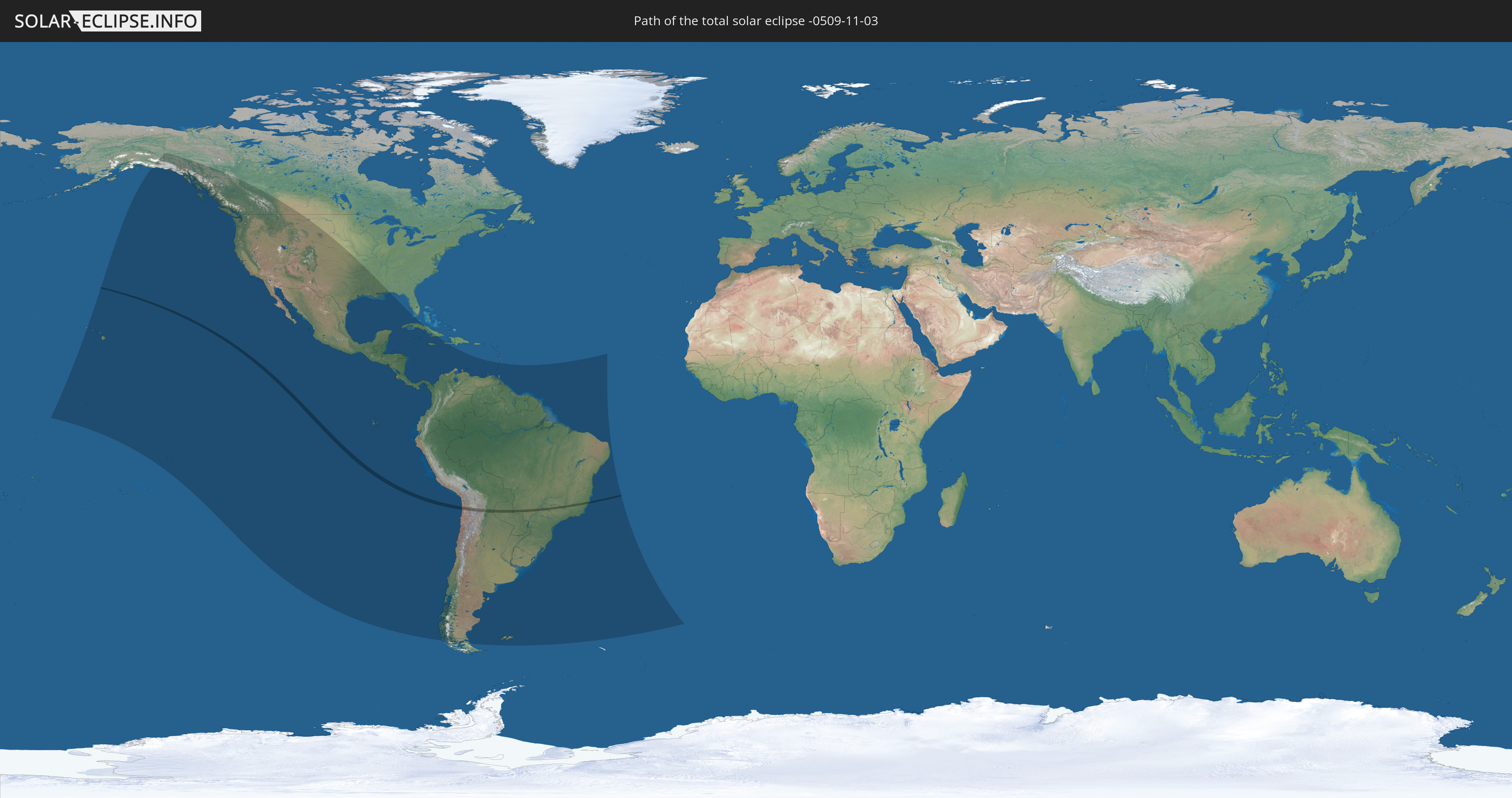
Die Sonnenfinsternis am 11/03/-0509 kann man in 37 Ländern als partielle Sonnenfinsternis beobachten.
Der Finsternispfad verläuft durch 4 Länder. Nur in diesen Ländern ist sie als total Sonnenfinsternis zu sehen.
In den folgenden Ländern ist die Sonnenfinsternis total zu sehen
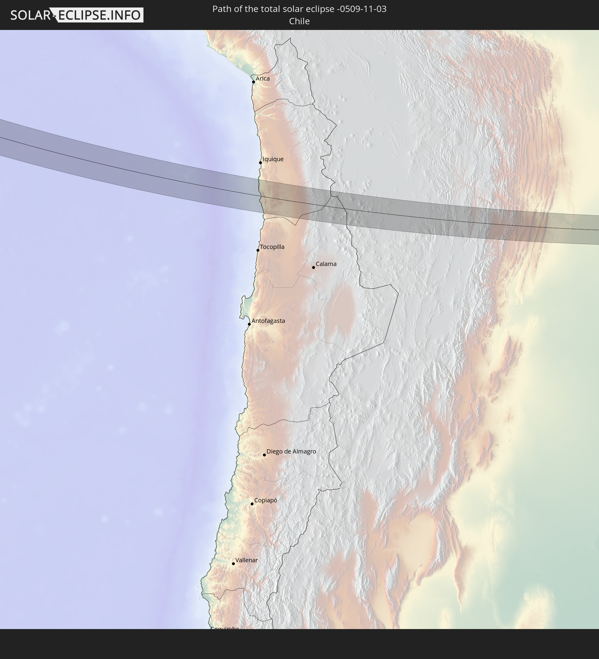 Chile
Chile
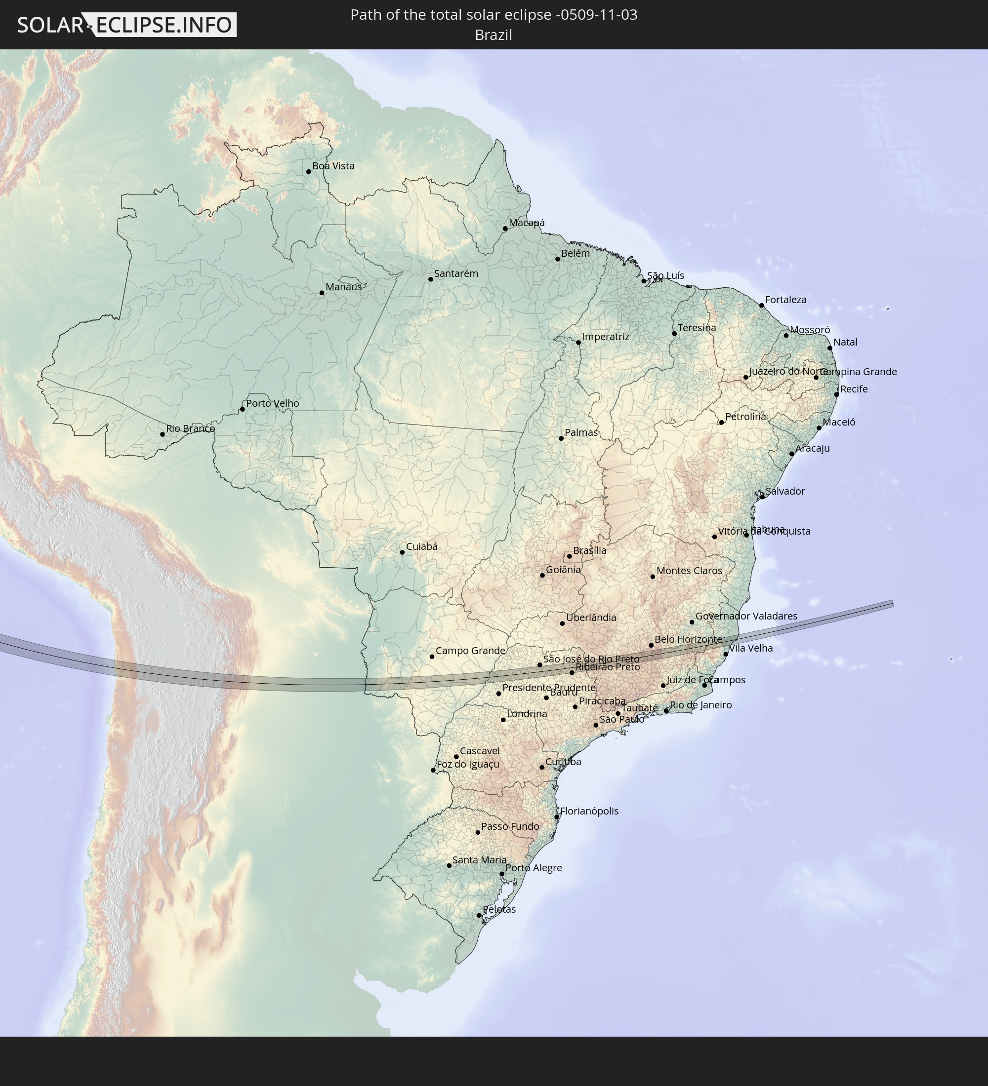 Brazil
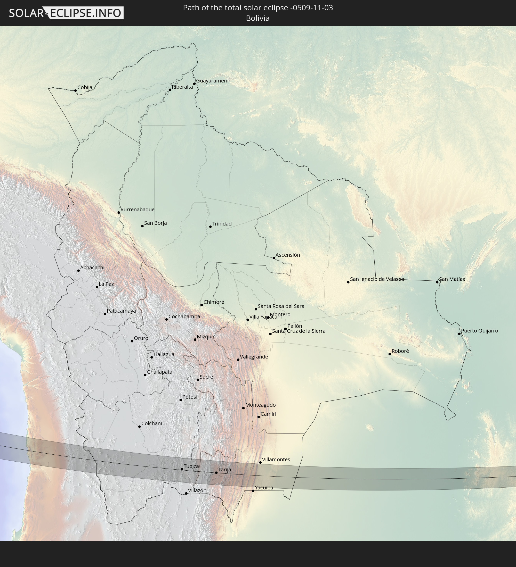 Bolivia
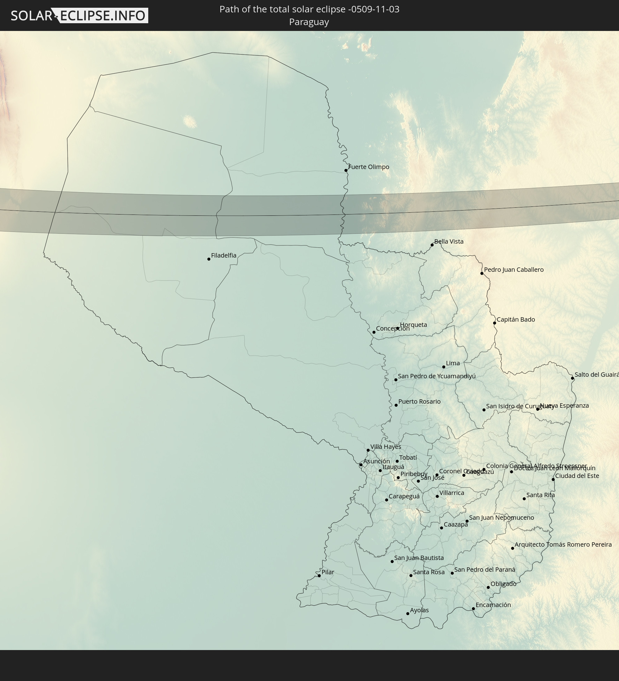 Paraguay
In den folgenden Ländern ist die Sonnenfinsternis partiell zu sehen
 United States
 United States Minor Outlying Islands
 Kiribati
 French Polynesia
 Canada
 Pitcairn Islands
 Mexico
 Chile
Chile
 Guatemala
 Ecuador
 El Salvador
 Honduras
 Belize
 Nicaragua
 Costa Rica
 Cuba
Cuba
 Panama
 Colombia
 Cayman Islands
 Peru
Peru
 Jamaica
 Haiti
Haiti
 Brazil
 Argentina
 Venezuela
 Aruba
Aruba
 Bolivia
 Paraguay
 Trinidad and Tobago
 Grenada
 Saint Vincent and the Grenadines
 Falkland Islands
 Guyana
 Barbados
 Uruguay
 Suriname
 French Guiana
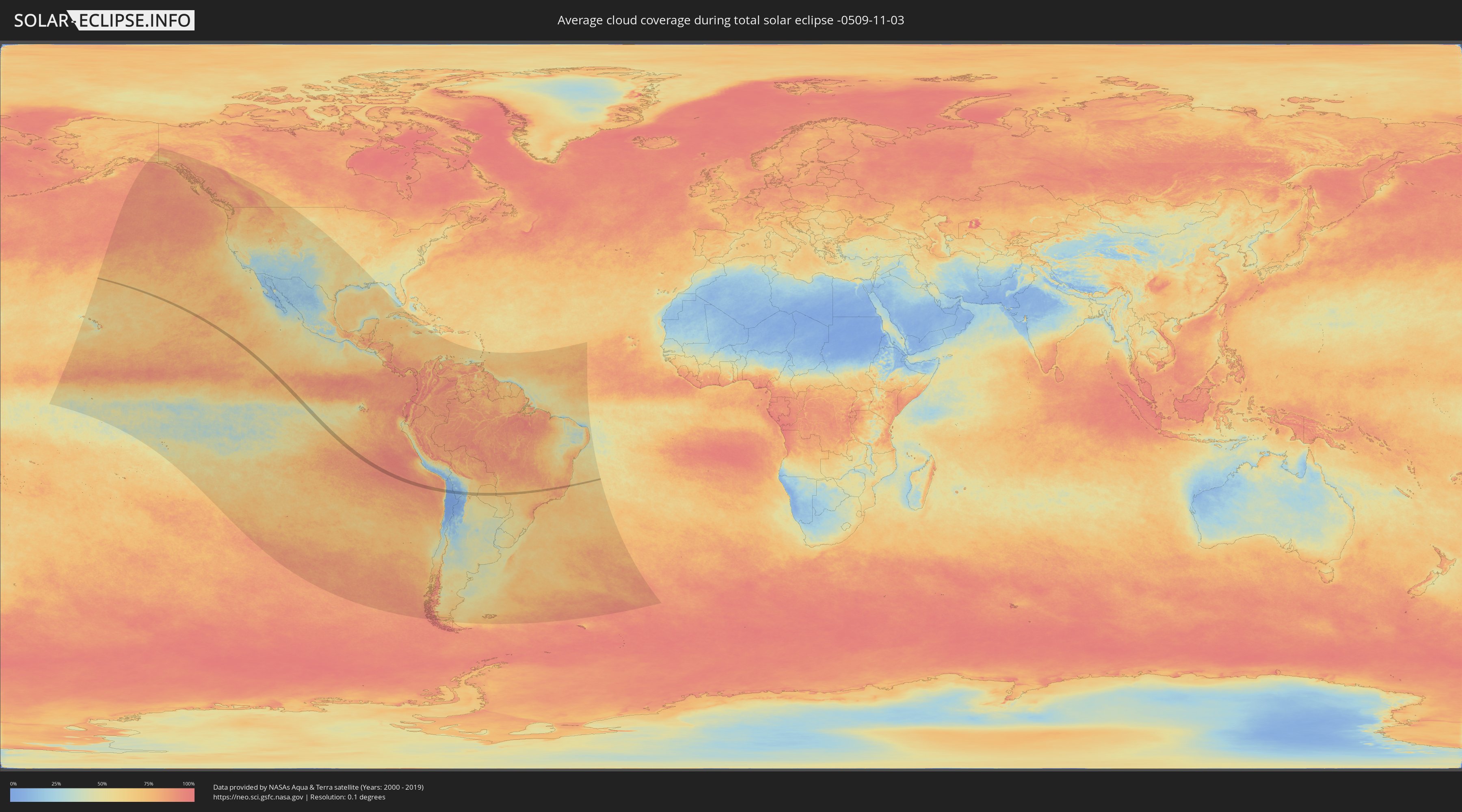
How will be the weather during the total solar eclipse on 11/03/-0509?
Where is the best place to see the total solar eclipse of 11/03/-0509?
The following maps show the average cloud coverage for the day of the total solar eclipse.
With the help of these maps, it is possible to find the place along the eclipse path, which has the best
chance of a cloudless sky.
Nevertheless, you should consider local circumstances and inform about the weather of your chosen
observation site.
The data is provided by NASAs satellites
AQUA and TERRA.
The cloud maps are averaged over a period of 19 years (2000 - 2019).

Detailed country maps
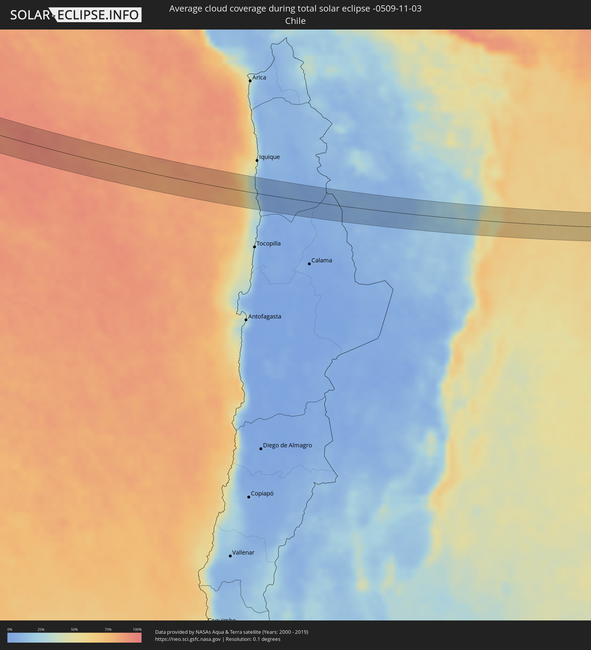 Chile
Chile
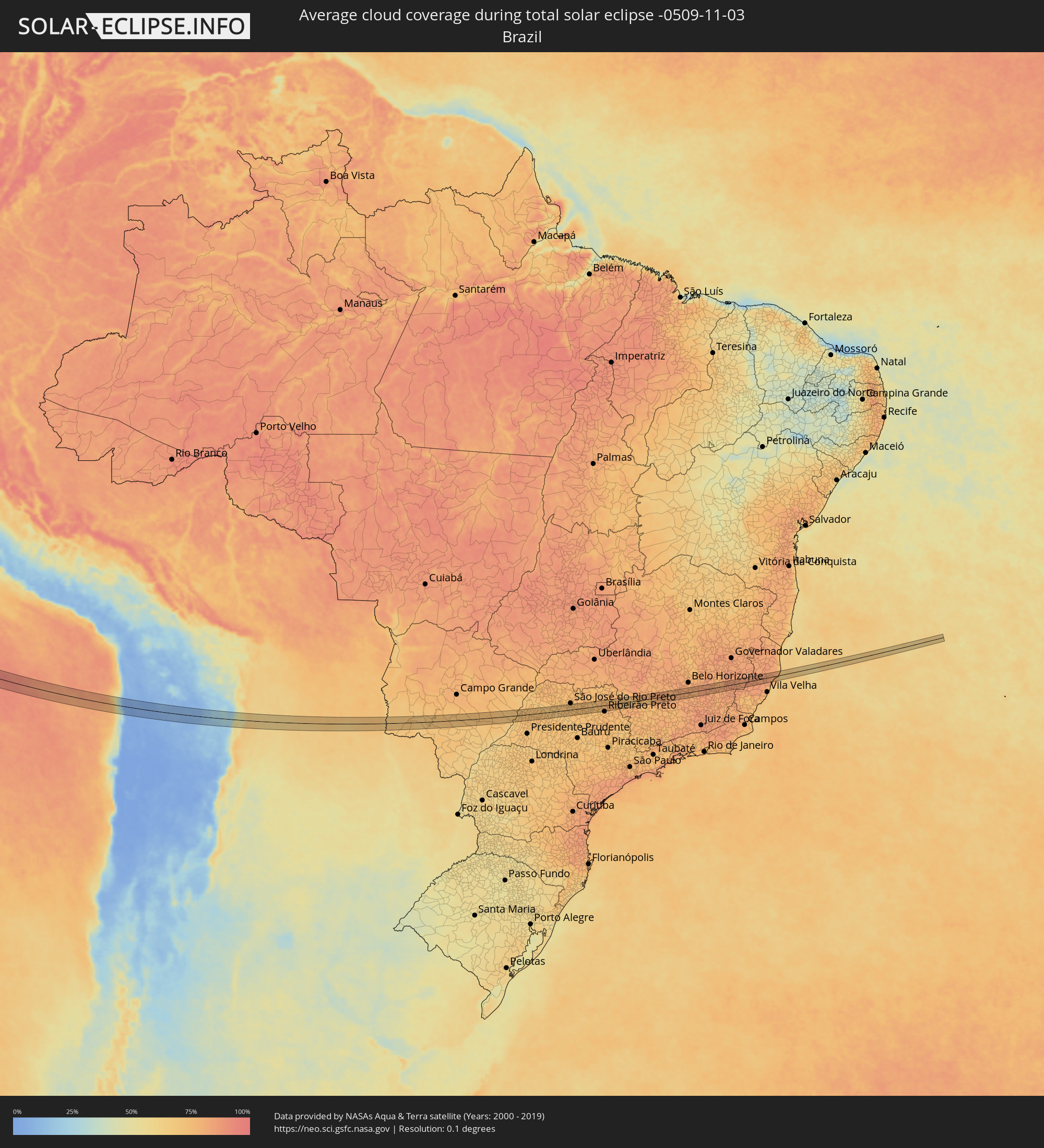 Brazil
 Bolivia
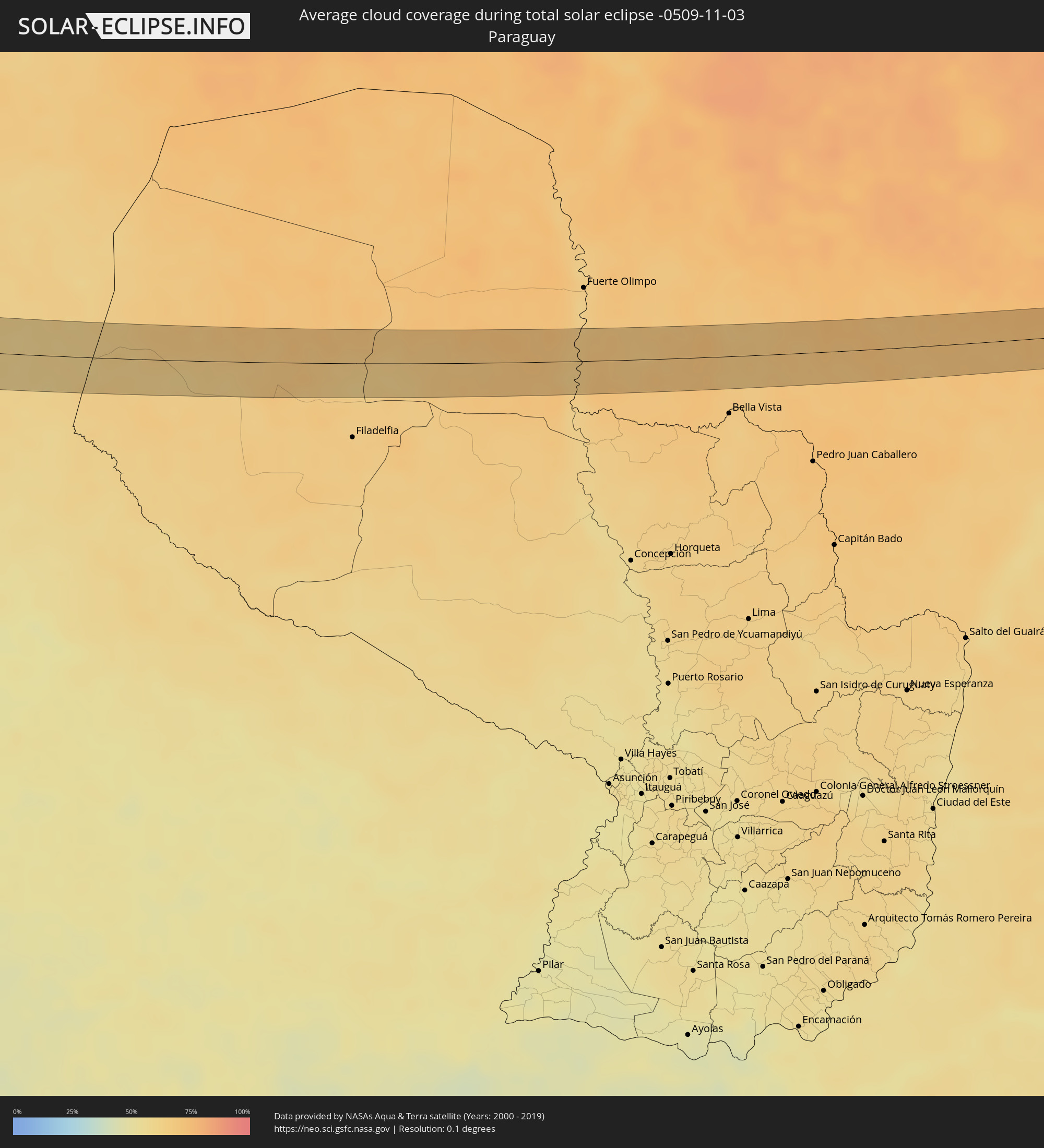 Paraguay
Cities inside the path of the eclipse
The following table shows all locations with a population of more than 5,000 inside the eclipse path. Cities which have more than 100,000 inhabitants are marked bold. A click at the locations opens a detailed map.
| City | Type | Eclipse duration | Local time of max. eclipse | Distance to central line | Ø Cloud coverage |
|
Tupiza, Potosí
|
total | - | 15:20:57 UTC-04:32 | 1 km | 22% |
|
Tarija, Tarija
|
total | - | 15:22:18 UTC-04:32 | 1 km | 48% |
|
Porto Murtinho, Mato Grosso do Sul
|
total | - | 16:24:17 UTC-03:38 | 2 km | 65% |
|
Jardim, Mato Grosso do Sul
|
total | - | 16:25:53 UTC-03:38 | 16 km | 69% |
|
Guia Lopes da Laguna, Mato Grosso do Sul
|
total | - | 16:25:54 UTC-03:38 | 18 km | 69% |
|
Maracaju, Mato Grosso do Sul
|
total | - | 16:26:45 UTC-03:38 | 4 km | 71% |
|
Rio Brilhante, Mato Grosso do Sul
|
total | - | 16:27:18 UTC-03:38 | 29 km | 68% |
|
Panorama, São Paulo
|
total | - | 17:01:20 UTC-03:06 | 2 km | 68% |
|
Tupi Paulista, São Paulo
|
total | - | 17:01:32 UTC-03:06 | 7 km | 73% |
|
Junqueirópolis, São Paulo
|
total | - | 17:01:39 UTC-03:06 | 23 km | 73% |
|
Mirandopólis, São Paulo
|
total | - | 17:01:50 UTC-03:06 | 15 km | 72% |
|
Valparaíso, São Paulo
|
total | - | 17:02:00 UTC-03:06 | 3 km | 74% |
|
Guararapes, São Paulo
|
total | - | 17:02:10 UTC-03:06 | 4 km | 73% |
|
Araçatuba, São Paulo
|
total | - | 17:02:18 UTC-03:06 | 0 km | 72% |
|
Birigui, São Paulo
|
total | - | 17:02:22 UTC-03:06 | 10 km | 70% |
|
Buritama, São Paulo
|
total | - | 17:02:28 UTC-03:06 | 12 km | 67% |
|
José Bonifácio, São Paulo
|
total | - | 17:02:46 UTC-03:06 | 8 km | 72% |
|
Bady Bassitt, São Paulo
|
total | - | 17:02:54 UTC-03:06 | 20 km | 73% |
|
Urupês, São Paulo
|
total | - | 17:03:01 UTC-03:06 | 13 km | 73% |
|
Catanduva, São Paulo
|
total | - | 17:03:12 UTC-03:06 | 10 km | 73% |
|
Pindorama, São Paulo
|
total | - | 17:03:15 UTC-03:06 | 16 km | 73% |
|
Santa Adélia, São Paulo
|
total | - | 17:03:19 UTC-03:06 | 24 km | 73% |
|
Severínia, São Paulo
|
total | - | 17:03:17 UTC-03:06 | 24 km | 73% |
|
Monte Azul Paulista, São Paulo
|
total | - | 17:03:23 UTC-03:06 | 11 km | 72% |
|
Bebedouro, São Paulo
|
total | - | 17:03:29 UTC-03:06 | 4 km | 71% |
|
Viradouro, São Paulo
|
total | - | 17:03:35 UTC-03:06 | 10 km | 73% |
|
Pitangueiras, São Paulo
|
total | - | 17:03:38 UTC-03:06 | 6 km | 73% |
|
Morro Agudo, São Paulo
|
total | - | 17:03:43 UTC-03:06 | 23 km | 75% |
|
Pontal, São Paulo
|
total | - | 17:03:44 UTC-03:06 | 10 km | 74% |
|
Sertãozinho, São Paulo
|
total | - | 17:03:46 UTC-03:06 | 23 km | 73% |
|
Orlândia, São Paulo
|
total | - | 17:03:48 UTC-03:06 | 21 km | 76% |
|
Jardinópolis, São Paulo
|
total | - | 17:03:53 UTC-03:06 | 13 km | 74% |
|
Nuporanga, São Paulo
|
total | - | 17:03:53 UTC-03:06 | 18 km | 76% |
|
Brodósqui, São Paulo
|
total | - | 17:03:57 UTC-03:06 | 12 km | 77% |
|
Batatais, São Paulo
|
total | - | 17:03:59 UTC-03:06 | 2 km | 76% |
|
Altinópolis, São Paulo
|
total | - | 17:04:06 UTC-03:06 | 19 km | 76% |
|
São Sebastião do Paraíso, Minas Gerais
|
total | - | 17:04:18 UTC-03:06 | 13 km | 75% |
|
Cássia, Minas Gerais
|
total | - | 17:04:19 UTC-03:06 | 23 km | 73% |
|
Itaú de Minas, Minas Gerais
|
total | - | 17:04:25 UTC-03:06 | 3 km | 71% |
|
Passos, Minas Gerais
|
total | - | 17:04:29 UTC-03:06 | 3 km | 72% |
|
Alpinópolis, Minas Gerais
|
total | - | 17:04:36 UTC-03:06 | 16 km | 79% |
|
Piuí, Minas Gerais
|
total | - | 17:04:48 UTC-03:06 | 21 km | 79% |
|
Formiga, Minas Gerais
|
total | - | 17:05:03 UTC-03:06 | 12 km | 82% |
|
Itapecerica, Minas Gerais
|
total | - | 17:05:11 UTC-03:06 | 7 km | 81% |
|
Oliveira, Minas Gerais
|
total | - | 17:05:19 UTC-03:06 | 23 km | 81% |
|
Cláudio, Minas Gerais
|
total | - | 17:05:20 UTC-03:06 | 4 km | 80% |
|
Congonhas, Minas Gerais
|
total | - | 17:05:43 UTC-03:06 | 19 km | 80% |
|
Itabirito, Minas Gerais
|
total | - | 17:05:44 UTC-03:06 | 8 km | 79% |
|
Ouro Branco, Minas Gerais
|
total | - | 17:05:47 UTC-03:06 | 24 km | 80% |
|
Ouro Preto, Minas Gerais
|
total | - | 17:05:51 UTC-03:06 | 13 km | 84% |
|
Mariana, Minas Gerais
|
total | - | 17:05:53 UTC-03:06 | 13 km | 86% |
|
Alvinópolis, Minas Gerais
|
total | - | 17:06:01 UTC-03:06 | 10 km | 84% |
|
Rio Casca, Minas Gerais
|
total | - | 17:06:10 UTC-03:06 | 10 km | 82% |
|
Matipó, Minas Gerais
|
total | - | 17:06:16 UTC-03:06 | 22 km | 82% |
|
Lajinha, Minas Gerais
|
total | - | 17:06:30 UTC-03:06 | 22 km | 83% |
|
Mutum, Minas Gerais
|
total | - | 17:06:34 UTC-03:06 | 13 km | 84% |
|
Itaguaçu, Espírito Santo
|
total | - | 17:06:44 UTC-03:06 | 1 km | 84% |
|
Santa Teresa, Espírito Santo
|
total | - | 17:06:49 UTC-03:06 | 19 km | 86% |
|
João Neiva, Espírito Santo
|
total | - | 17:06:52 UTC-03:06 | 3 km | 82% |
|
Ibiraçu, Espírito Santo
|
total | - | 17:06:52 UTC-03:06 | 12 km | 82% |
|
Aracruz, Espírito Santo
|
total | - | 17:06:54 UTC-03:06 | 13 km | 83% |