Total solar eclipse of 07/31/-0522
| Day of week: | Monday |
| Maximum duration of eclipse: | 04m49s |
| Maximum width of eclipse path: | 221 km |
| Saros cycle: | 66 |
| Coverage: | 100% |
| Magnitude: | 1.0527 |
| Gamma: | -0.6223 |
Wo kann man die Sonnenfinsternis vom 07/31/-0522 sehen?
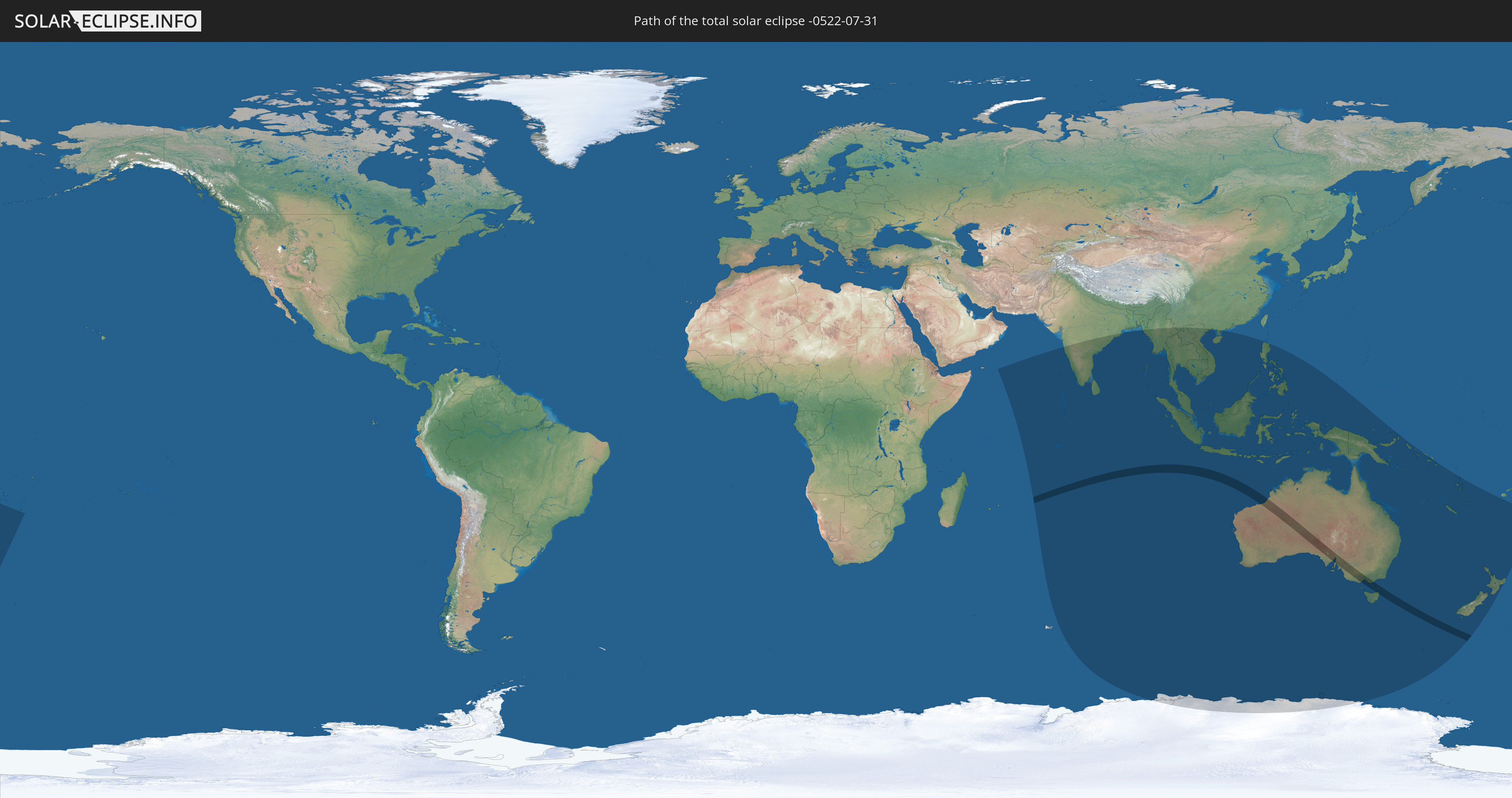
Die Sonnenfinsternis am 07/31/-0522 kann man in 31 Ländern als partielle Sonnenfinsternis beobachten.
Der Finsternispfad verläuft durch 3 Länder. Nur in diesen Ländern ist sie als total Sonnenfinsternis zu sehen.
In den folgenden Ländern ist die Sonnenfinsternis total zu sehen
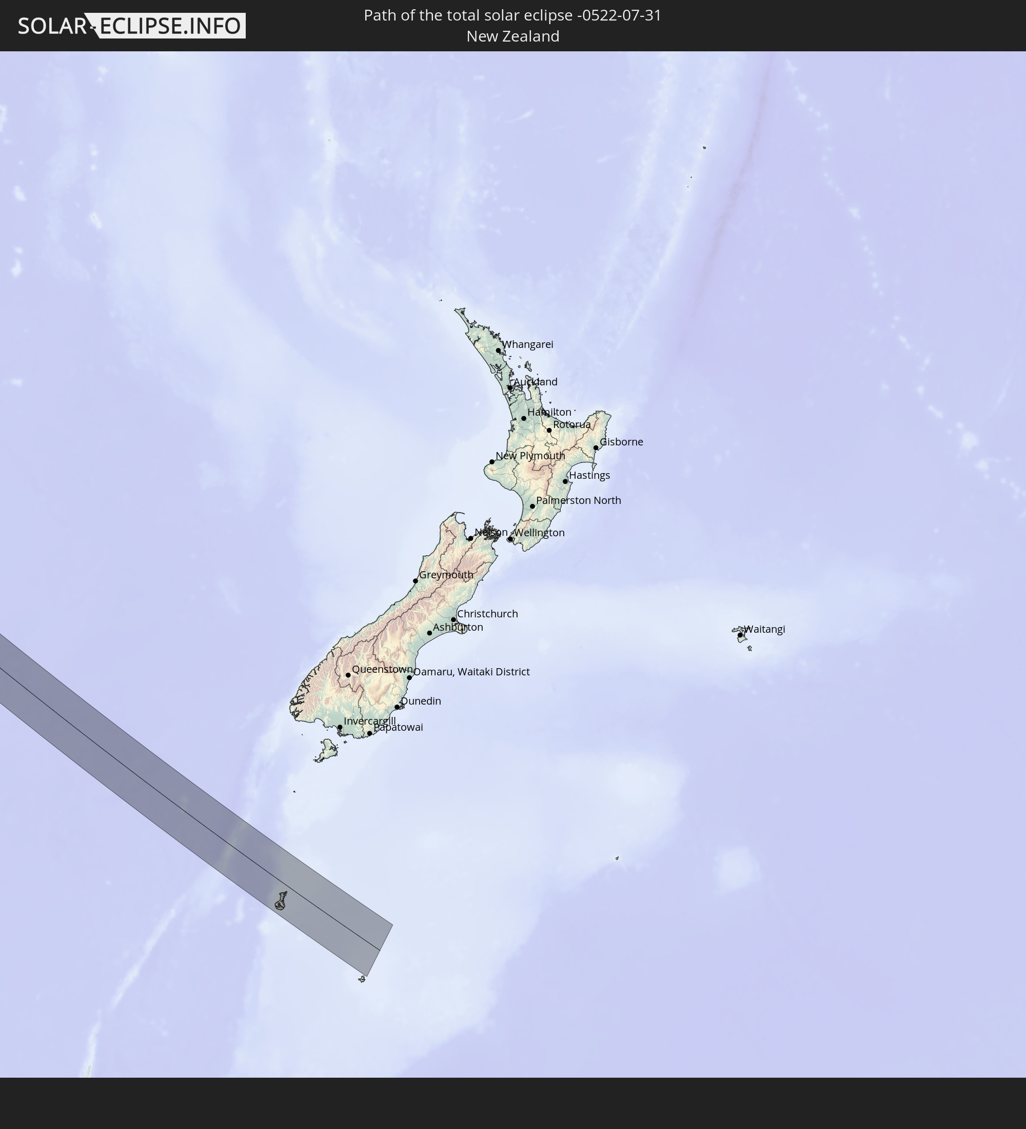 New Zealand
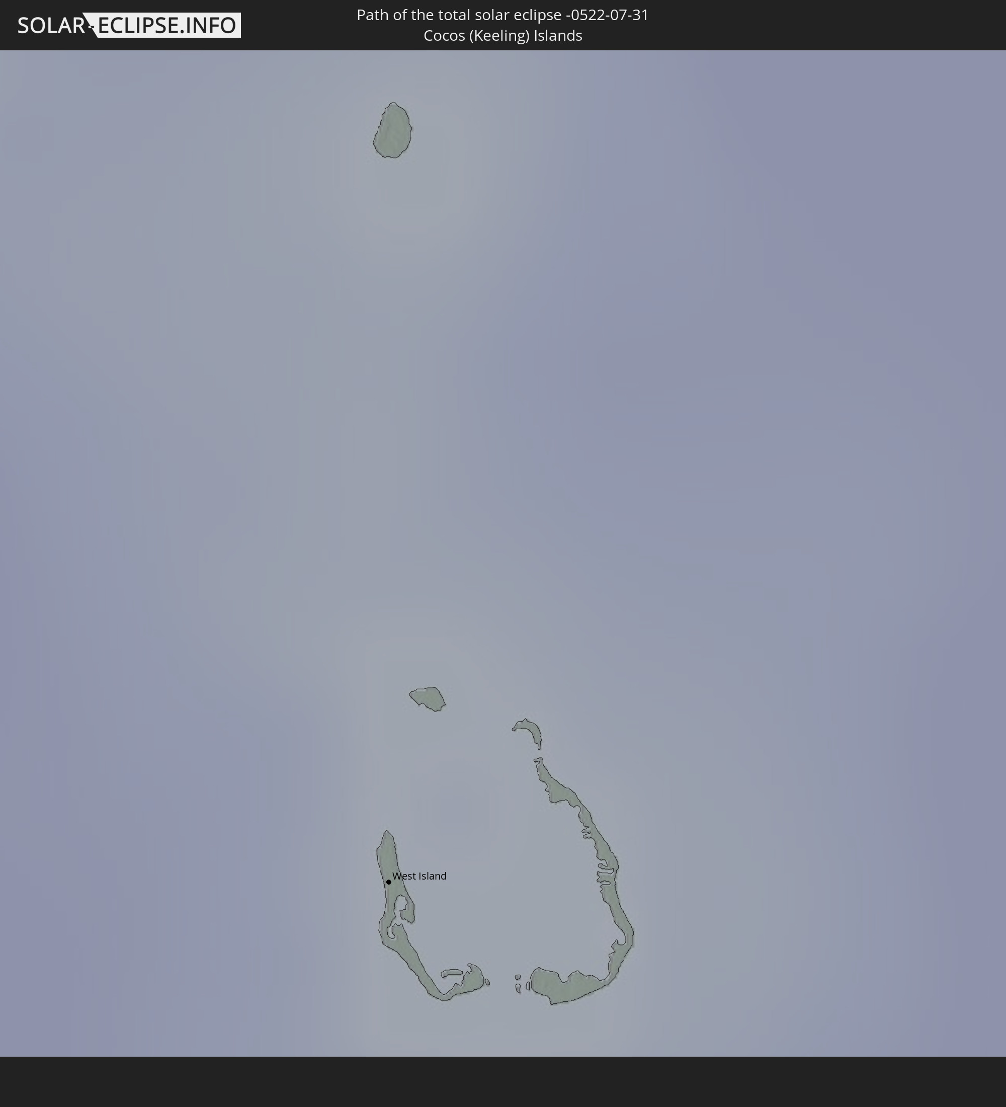 Cocos Islands
 Australia
In den folgenden Ländern ist die Sonnenfinsternis partiell zu sehen
 Antarctica
 Fiji
Fiji
 New Zealand
 Tonga
Tonga
 French Southern and Antarctic Lands
 India
India
 British Indian Ocean Territory
 Maldives
 China
China
 Sri Lanka
 Bangladesh
 Myanmar
 Indonesia
 Cocos Islands
 Thailand
 Malaysia
 Laos
Laos
 Vietnam
 Cambodia
 Singapore
 Christmas Island
 Australia
 Brunei
 Philippines
 East Timor
 Palau
Palau
 Papua New Guinea
 Solomon Islands
 New Caledonia
 Vanuatu
 Norfolk Island
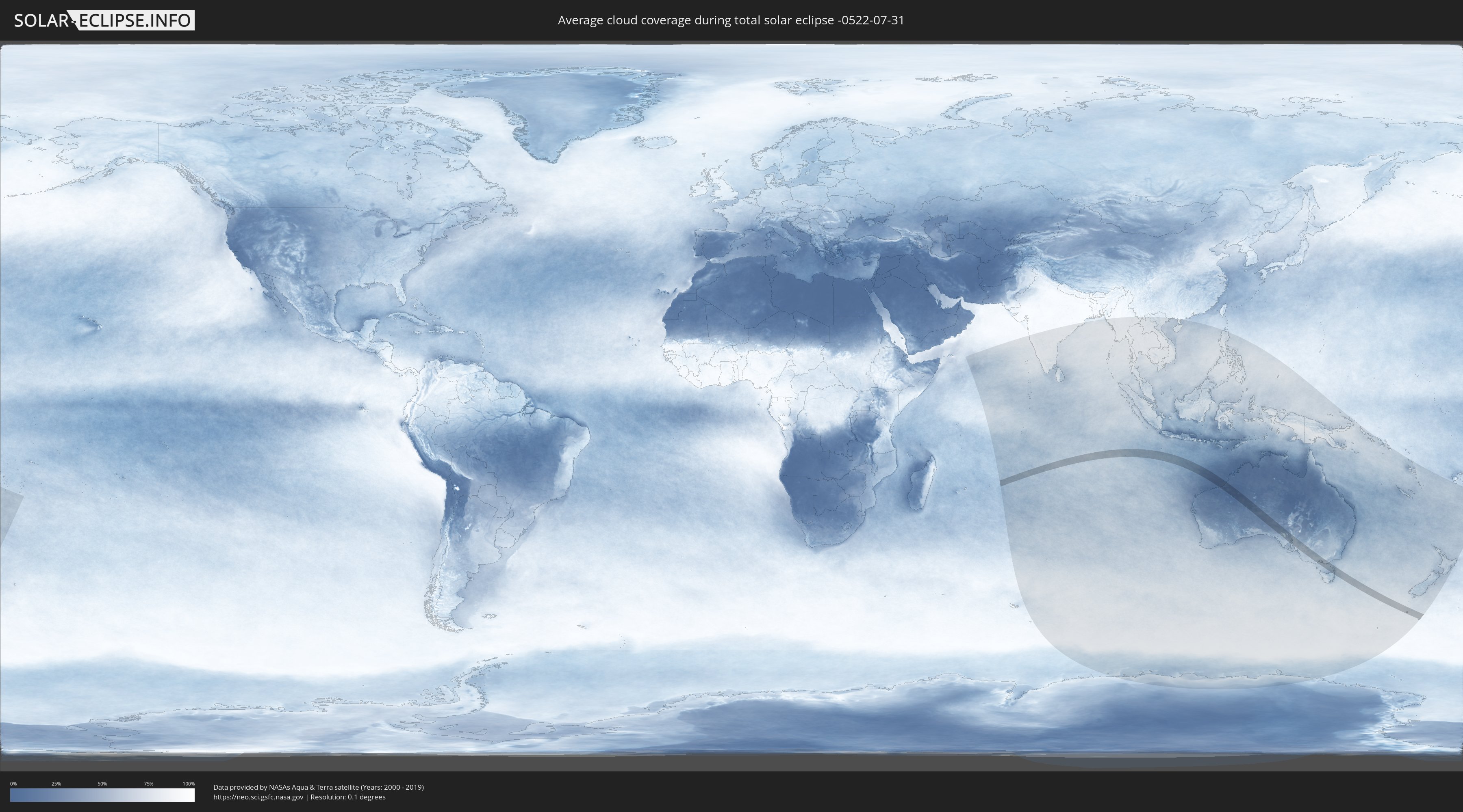
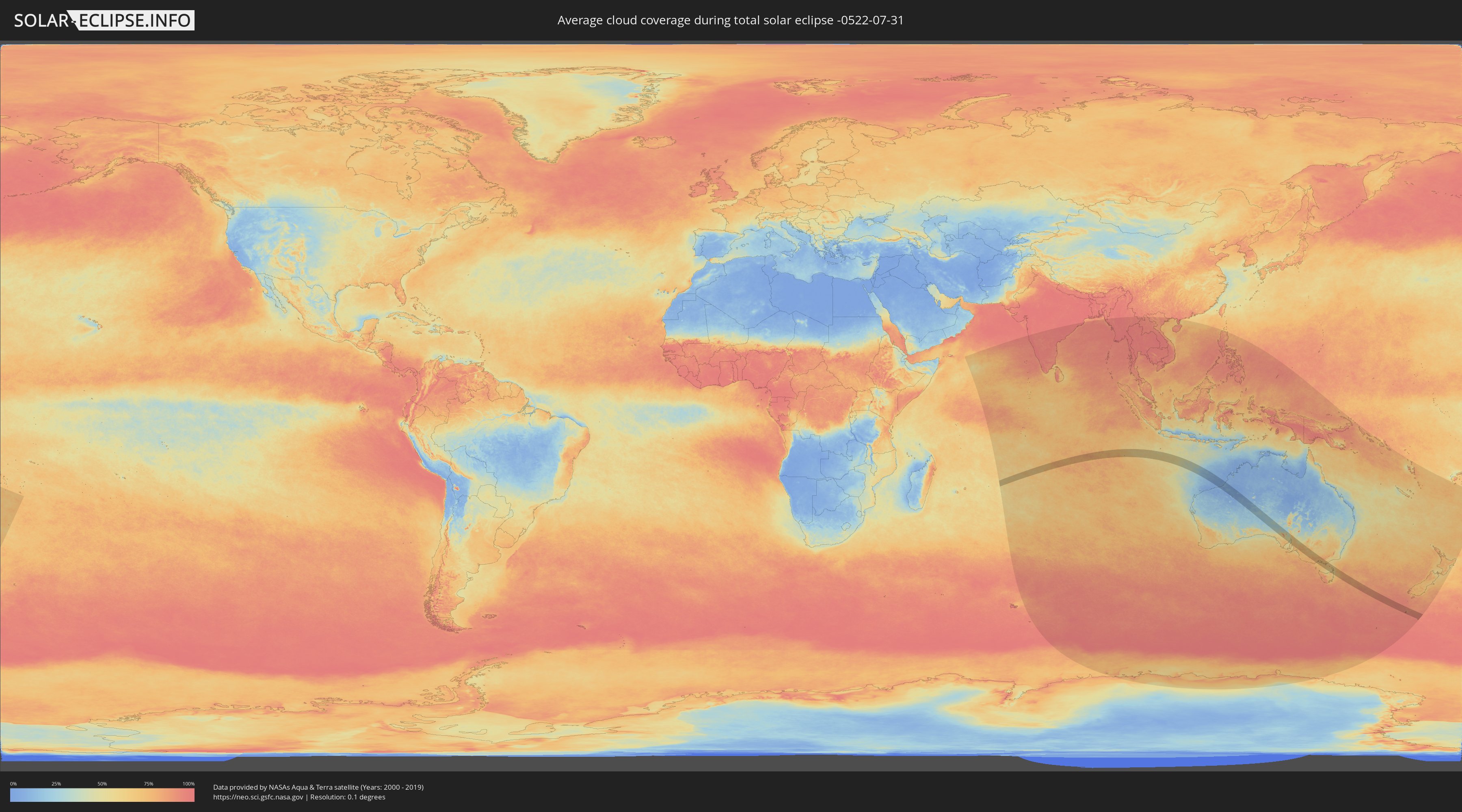
How will be the weather during the total solar eclipse on 07/31/-0522?
Where is the best place to see the total solar eclipse of 07/31/-0522?
The following maps show the average cloud coverage for the day of the total solar eclipse.
With the help of these maps, it is possible to find the place along the eclipse path, which has the best
chance of a cloudless sky.
Nevertheless, you should consider local circumstances and inform about the weather of your chosen
observation site.
The data is provided by NASAs satellites
AQUA and TERRA.
The cloud maps are averaged over a period of 19 years (2000 - 2019).
Detailed country maps
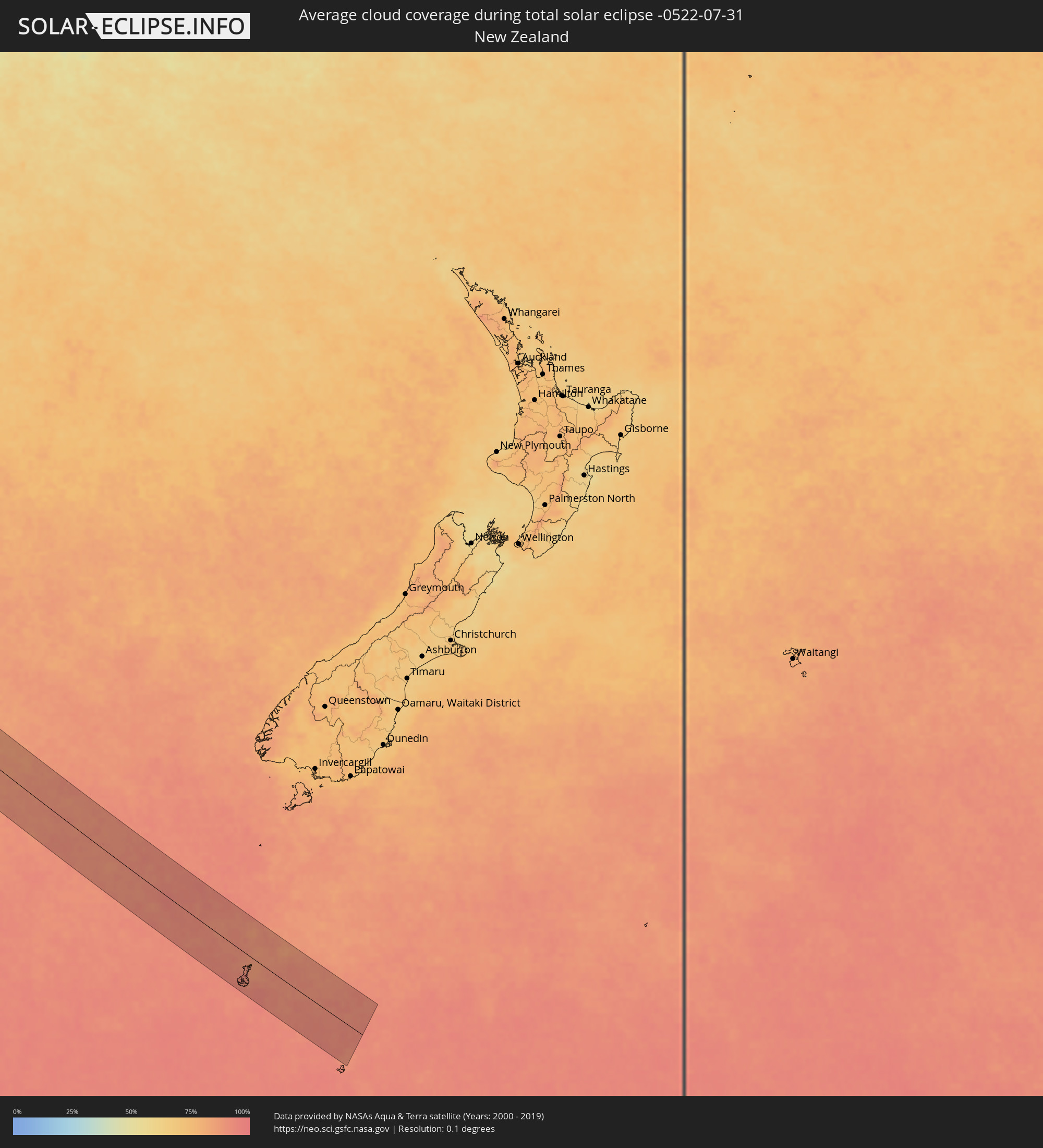 New Zealand
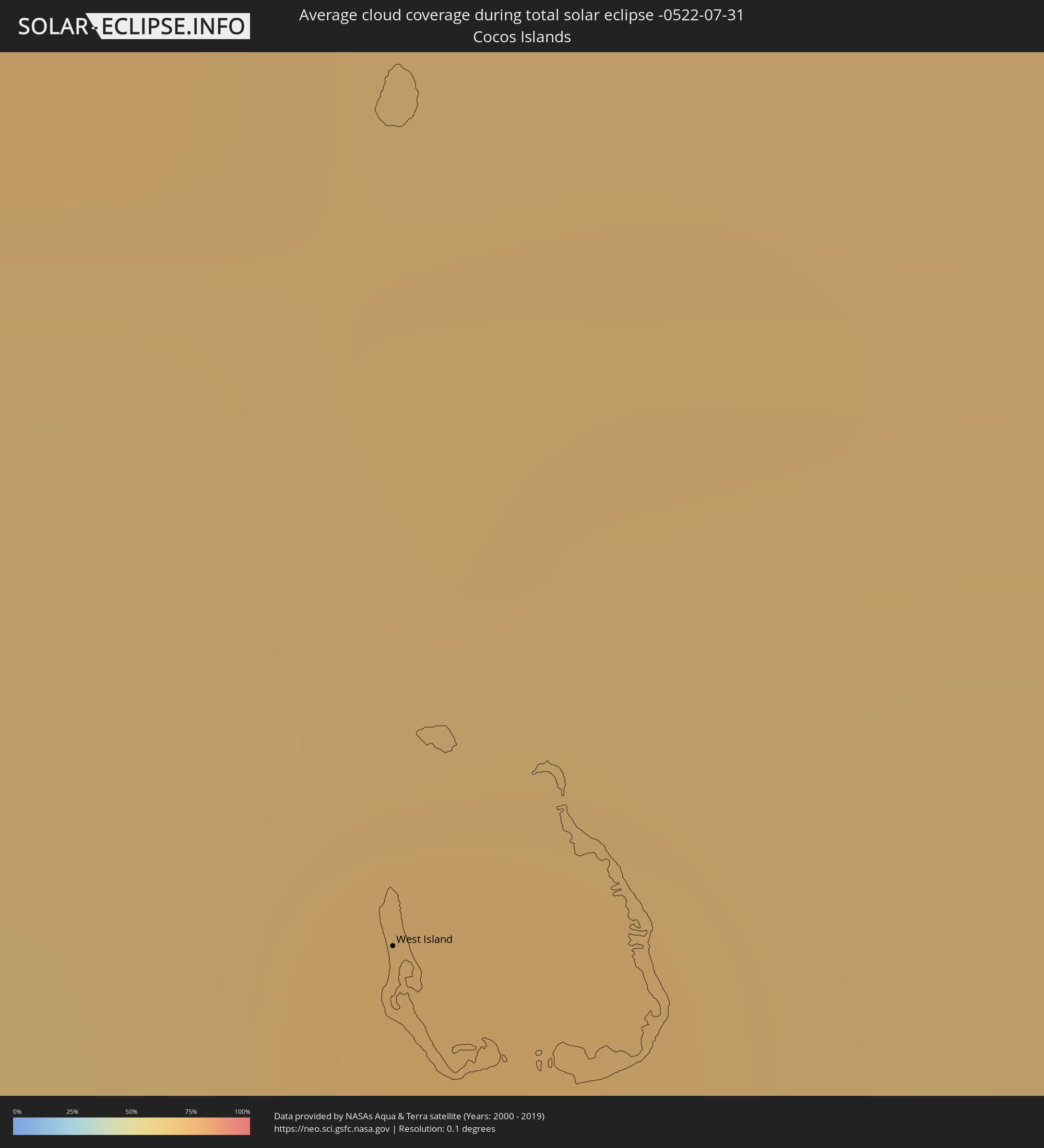 Cocos Islands
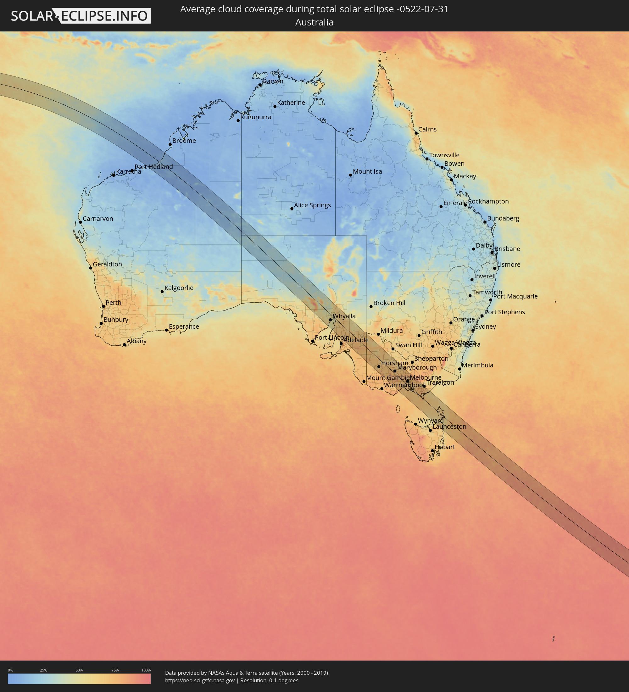 Australia
Cities inside the path of the eclipse
The following table shows all locations with a population of more than 5,000 inside the eclipse path. Cities which have more than 100,000 inhabitants are marked bold. A click at the locations opens a detailed map.
| City | Type | Eclipse duration | Local time of max. eclipse | Distance to central line | Ø Cloud coverage |
|
West Island
|
total | - | 09:04:56 UTC+06:30 | 69 km | 69% |
|
Whyalla, South Australia
|
total | - | 13:58:49 UTC+09:30 | 38 km | 51% |
|
Port Augusta, South Australia
|
total | - | 13:58:57 UTC+09:30 | 19 km | 55% |
|
Port Pirie, South Australia
|
total | - | 13:59:34 UTC+09:30 | 22 km | 62% |
|
Horsham, Victoria
|
total | - | 14:36:05 UTC+10:00 | 49 km | 71% |
|
Ararat, Victoria
|
total | - | 14:37:02 UTC+10:00 | 53 km | 74% |
|
Maryborough, Victoria
|
total | - | 14:38:02 UTC+10:00 | 15 km | 72% |
|
Sebastopol, Victoria
|
total | - | 14:38:10 UTC+10:00 | 23 km | 79% |
|
Ballarat, Victoria
|
total | - | 14:38:11 UTC+10:00 | 21 km | 79% |
|
Castlemaine, Victoria
|
total | - | 14:38:37 UTC+10:00 | 42 km | 72% |
|
Golden Square, Victoria
|
total | - | 14:38:39 UTC+10:00 | 68 km | 68% |
|
Bendigo, Victoria
|
total | - | 14:38:41 UTC+10:00 | 71 km | 68% |
|
Kennington, Victoria
|
total | - | 14:38:43 UTC+10:00 | 70 km | 68% |
|
Hamlyn Heights, Victoria
|
total | - | 14:38:45 UTC+10:00 | 39 km | 75% |
|
Geelong, Victoria
|
total | - | 14:38:47 UTC+10:00 | 39 km | 70% |
|
Leopold, Victoria
|
total | - | 14:38:55 UTC+10:00 | 36 km | 71% |
|
Clifton Springs, Victoria
|
total | - | 14:39:01 UTC+10:00 | 29 km | 70% |
|
Melton South, Victoria
|
total | - | 14:39:03 UTC+10:00 | 10 km | 72% |
|
Melton, Victoria
|
total | - | 14:39:04 UTC+10:00 | 13 km | 72% |
|
Kurunjang, Victoria
|
total | - | 14:39:05 UTC+10:00 | 14 km | 72% |
|
Hoppers Crossing, Victoria
|
total | - | 14:39:12 UTC+10:00 | 3 km | 68% |
|
Sunbury, Victoria
|
total | - | 14:39:14 UTC+10:00 | 30 km | 70% |
|
Derrimut, Victoria
|
total | - | 14:39:17 UTC+10:00 | 14 km | 71% |
|
Delahey, Victoria
|
total | - | 14:39:17 UTC+10:00 | 21 km | 72% |
|
Cairnlea, Victoria
|
total | - | 14:39:18 UTC+10:00 | 18 km | 71% |
|
Saint Albans, Victoria
|
total | - | 14:39:19 UTC+10:00 | 21 km | 72% |
|
Rye, Victoria
|
total | - | 14:39:19 UTC+10:00 | 31 km | 72% |
|
Braybrook, Victoria
|
total | - | 14:39:23 UTC+10:00 | 20 km | 68% |
|
Maidstone, Victoria
|
total | - | 14:39:24 UTC+10:00 | 21 km | 68% |
|
Tullamarine, Victoria
|
total | - | 14:39:25 UTC+10:00 | 28 km | 68% |
|
Airport West, Victoria
|
total | - | 14:39:25 UTC+10:00 | 26 km | 68% |
|
Gladstone Park, Victoria
|
total | - | 14:39:25 UTC+10:00 | 30 km | 68% |
|
Flemington, Victoria
|
total | - | 14:39:28 UTC+10:00 | 24 km | 68% |
|
Parkville, Victoria
|
total | - | 14:39:29 UTC+10:00 | 26 km | 68% |
|
Docklands, Victoria
|
total | - | 14:39:29 UTC+10:00 | 23 km | 68% |
|
Coburg North, Victoria
|
total | - | 14:39:30 UTC+10:00 | 31 km | 68% |
|
Melbourne, Victoria
|
total | - | 14:39:30 UTC+10:00 | 24 km | 68% |
|
South Melbourne, Victoria
|
total | - | 14:39:31 UTC+10:00 | 22 km | 68% |
|
Carlton North, Victoria
|
total | - | 14:39:31 UTC+10:00 | 27 km | 68% |
|
Brunswick East, Victoria
|
total | - | 14:39:31 UTC+10:00 | 28 km | 68% |
|
Fitzroy, Victoria
|
total | - | 14:39:31 UTC+10:00 | 26 km | 68% |
|
Windsor, Victoria
|
total | - | 14:39:32 UTC+10:00 | 22 km | 68% |
|
Clifton Hill, Victoria
|
total | - | 14:39:33 UTC+10:00 | 27 km | 68% |
|
Albert Park, Victoria
|
total | - | 14:39:33 UTC+10:00 | 24 km | 68% |
|
Black Rock, Victoria
|
total | - | 14:39:34 UTC+10:00 | 14 km | 67% |
|
Mount Martha, Victoria
|
total | - | 14:39:33 UTC+10:00 | 11 km | 70% |
|
Fairfield, Victoria
|
total | - | 14:39:34 UTC+10:00 | 30 km | 68% |
|
Ormond, Victoria
|
total | - | 14:39:35 UTC+10:00 | 21 km | 68% |
|
Epping, Victoria
|
total | - | 14:39:35 UTC+10:00 | 42 km | 68% |
|
Cheltenham, Victoria
|
total | - | 14:39:36 UTC+10:00 | 16 km | 67% |
|
Kew East, Victoria
|
total | - | 14:39:37 UTC+10:00 | 30 km | 68% |
|
Heidelberg Heights, Victoria
|
total | - | 14:39:37 UTC+10:00 | 35 km | 68% |
|
Murrumbeena, Victoria
|
total | - | 14:39:37 UTC+10:00 | 23 km | 69% |
|
Rosanna, Victoria
|
total | - | 14:39:38 UTC+10:00 | 35 km | 68% |
|
Ashburton, Victoria
|
total | - | 14:39:39 UTC+10:00 | 26 km | 69% |
|
Mordialloc, Victoria
|
total | - | 14:39:38 UTC+10:00 | 15 km | 69% |
|
Hughesdale, Victoria
|
total | - | 14:39:39 UTC+10:00 | 24 km | 69% |
|
Canterbury, Victoria
|
total | - | 14:39:39 UTC+10:00 | 30 km | 68% |
|
Oakleigh South, Victoria
|
total | - | 14:39:39 UTC+10:00 | 22 km | 69% |
|
Viewbank, Victoria
|
total | - | 14:39:40 UTC+10:00 | 38 km | 68% |
|
Mernda, Victoria
|
total | - | 14:39:40 UTC+10:00 | 49 km | 72% |
|
Aspendale, Victoria
|
total | - | 14:39:40 UTC+10:00 | 14 km | 69% |
|
Clarinda, Victoria
|
total | - | 14:39:41 UTC+10:00 | 23 km | 69% |
|
Chelsea, Victoria
|
total | - | 14:39:41 UTC+10:00 | 13 km | 70% |
|
Montmorency, Victoria
|
total | - | 14:39:41 UTC+10:00 | 41 km | 68% |
|
Aspendale Gardens, Victoria
|
total | - | 14:39:41 UTC+10:00 | 16 km | 69% |
|
Box Hill South, Victoria
|
total | - | 14:39:41 UTC+10:00 | 32 km | 68% |
|
Bonbeach, Victoria
|
total | - | 14:39:41 UTC+10:00 | 12 km | 70% |
|
Frankston, Victoria
|
total | - | 14:39:41 UTC+10:00 | 6 km | 70% |
|
Box Hill, Victoria
|
total | - | 14:39:42 UTC+10:00 | 33 km | 68% |
|
Patterson Lakes, Victoria
|
total | - | 14:39:43 UTC+10:00 | 13 km | 70% |
|
Doncaster East, Victoria
|
total | - | 14:39:43 UTC+10:00 | 37 km | 68% |
|
Eltham North, Victoria
|
total | - | 14:39:44 UTC+10:00 | 44 km | 71% |
|
Blackburn North, Victoria
|
total | - | 14:39:44 UTC+10:00 | 35 km | 71% |
|
Somerville, Victoria
|
total | - | 14:39:44 UTC+10:00 | 2 km | 67% |
|
Hastings, Victoria
|
total | - | 14:39:45 UTC+10:00 | 4 km | 65% |
|
Noble Park North, Victoria
|
total | - | 14:39:46 UTC+10:00 | 26 km | 72% |
|
Skye, Victoria
|
total | - | 14:39:48 UTC+10:00 | 14 km | 71% |
|
Phillip Island, Victoria
|
total | - | 14:39:47 UTC+10:00 | 16 km | 70% |
|
Scoresby, Victoria
|
total | - | 14:39:49 UTC+10:00 | 32 km | 72% |
|
Rowville, Victoria
|
total | - | 14:39:49 UTC+10:00 | 30 km | 72% |
|
Doveton, Victoria
|
total | - | 14:39:49 UTC+10:00 | 25 km | 72% |
|
Knoxfield, Victoria
|
total | - | 14:39:50 UTC+10:00 | 34 km | 72% |
|
Lynbrook, Victoria
|
total | - | 14:39:50 UTC+10:00 | 21 km | 69% |
|
Cranbourne West, Victoria
|
total | - | 14:39:51 UTC+10:00 | 18 km | 69% |
|
Cranbourne East, Victoria
|
total | - | 14:39:53 UTC+10:00 | 18 km | 69% |
|
Bayswater North, Victoria
|
total | - | 14:39:54 UTC+10:00 | 42 km | 75% |
|
Lysterfield, Victoria
|
total | - | 14:39:54 UTC+10:00 | 34 km | 73% |
|
Croydon North, Victoria
|
total | - | 14:39:54 UTC+10:00 | 46 km | 75% |
|
Narre Warren North, Victoria
|
total | - | 14:39:55 UTC+10:00 | 30 km | 71% |
|
Upwey, Victoria
|
total | - | 14:39:56 UTC+10:00 | 38 km | 73% |
|
Montrose, Victoria
|
total | - | 14:39:57 UTC+10:00 | 46 km | 75% |
|
Berwick, Victoria
|
total | - | 14:39:57 UTC+10:00 | 28 km | 70% |
|
Lilydale, Victoria
|
total | - | 14:39:57 UTC+10:00 | 52 km | 75% |
|
Emerald, Victoria
|
total | - | 14:40:03 UTC+10:00 | 42 km | 70% |
|
Pakenham South, Victoria
|
total | - | 14:40:08 UTC+10:00 | 30 km | 69% |
|
Healesville, Victoria
|
total | - | 14:40:09 UTC+10:00 | 70 km | 74% |
|
North Wonthaggi, Victoria
|
total | - | 14:40:12 UTC+10:00 | 4 km | 66% |
|
Warragul, Victoria
|
total | - | 14:40:36 UTC+10:00 | 51 km | 75% |
|
Moe, Victoria
|
total | - | 14:40:59 UTC+10:00 | 69 km | 74% |
|
Traralgon, Victoria
|
total | - | 14:41:17 UTC+10:00 | 84 km | 73% |