Total solar eclipse of 09/10/-0618
| Day of week: | Sunday |
| Maximum duration of eclipse: | 03m28s |
| Maximum width of eclipse path: | 232 km |
| Saros cycle: | 44 |
| Coverage: | 100% |
| Magnitude: | 1.0503 |
| Gamma: | 0.7056 |
Wo kann man die Sonnenfinsternis vom 09/10/-0618 sehen?

Die Sonnenfinsternis am 09/10/-0618 kann man in 12 Ländern als partielle Sonnenfinsternis beobachten.
Der Finsternispfad verläuft durch 4 Länder. Nur in diesen Ländern ist sie als total Sonnenfinsternis zu sehen.
In den folgenden Ländern ist die Sonnenfinsternis total zu sehen
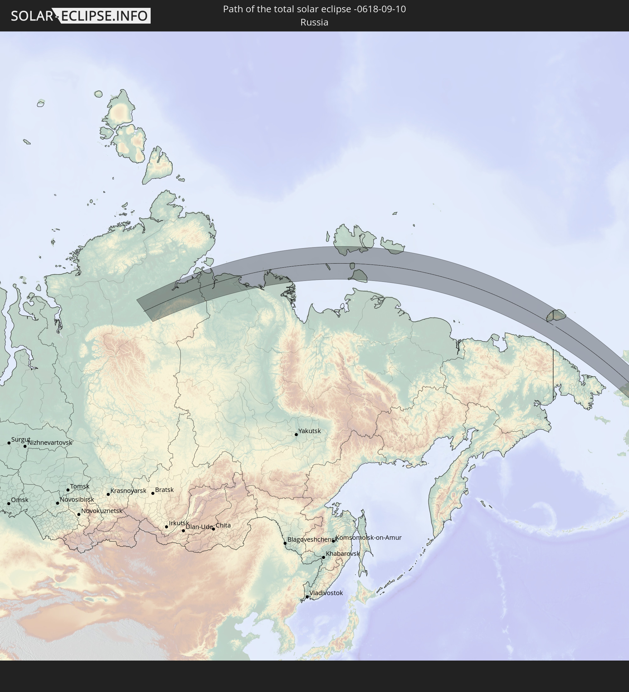 Russia
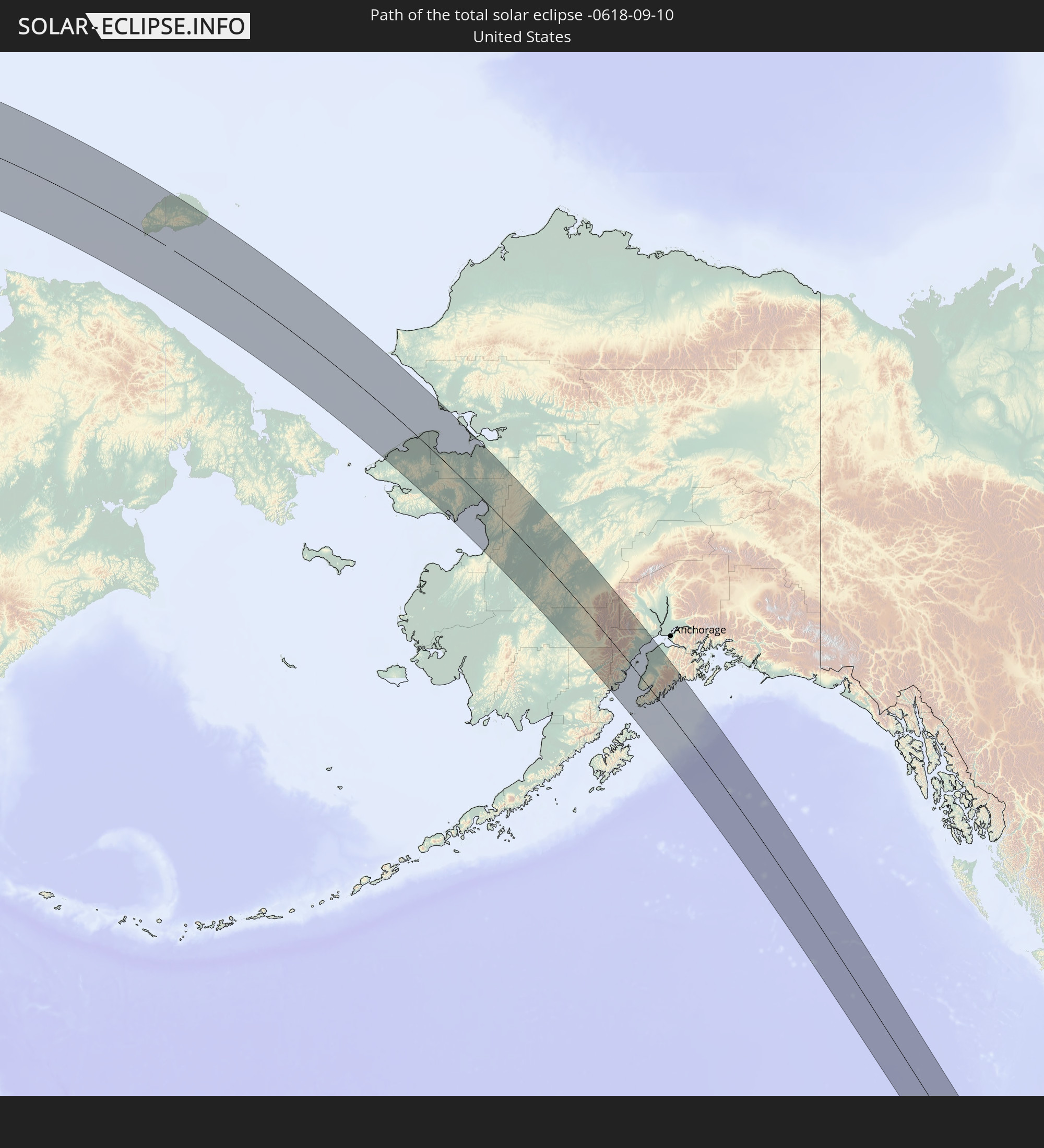 United States
 Mexico
 Guatemala
In den folgenden Ländern ist die Sonnenfinsternis partiell zu sehen


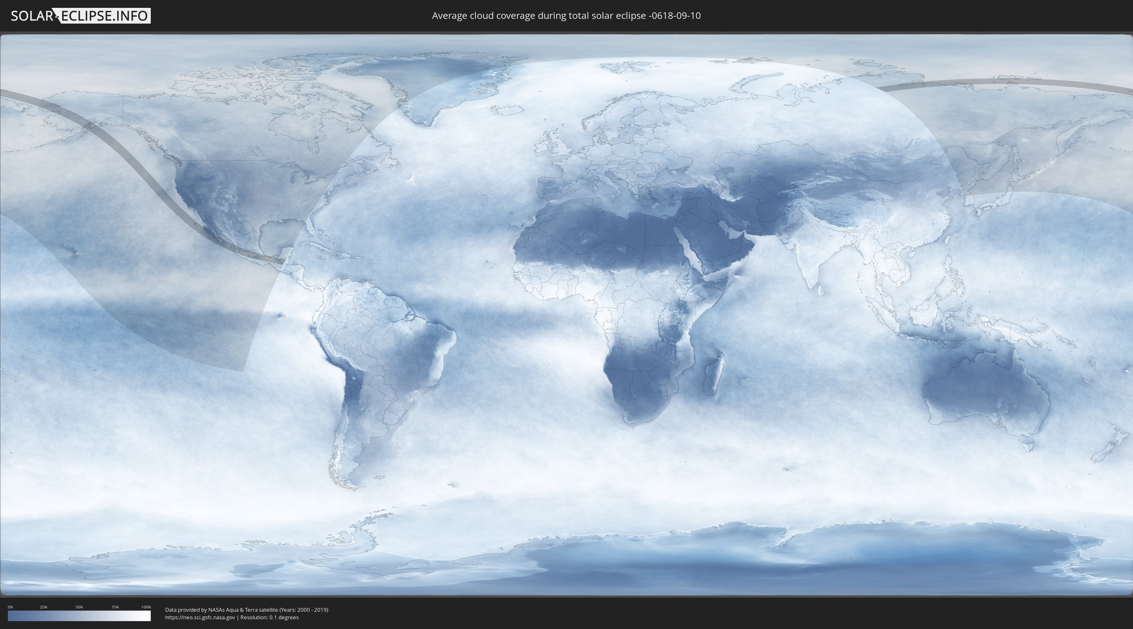
How will be the weather during the total solar eclipse on 09/10/-0618?
Where is the best place to see the total solar eclipse of 09/10/-0618?
The following maps show the average cloud coverage for the day of the total solar eclipse.
With the help of these maps, it is possible to find the place along the eclipse path, which has the best
chance of a cloudless sky.
Nevertheless, you should consider local circumstances and inform about the weather of your chosen
observation site.
The data is provided by NASAs satellites
AQUA and TERRA.
The cloud maps are averaged over a period of 19 years (2000 - 2019).

Detailed country maps
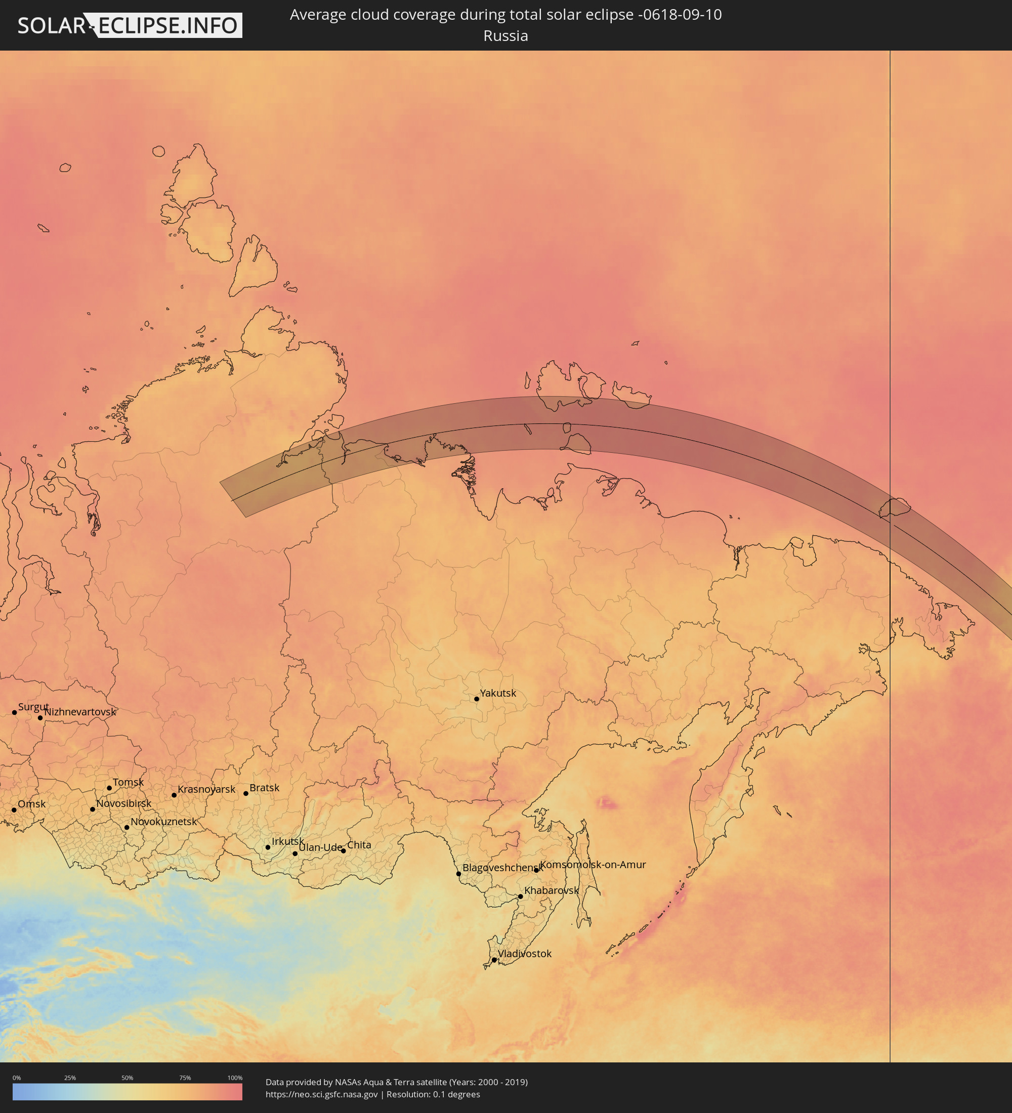 Russia
 United States
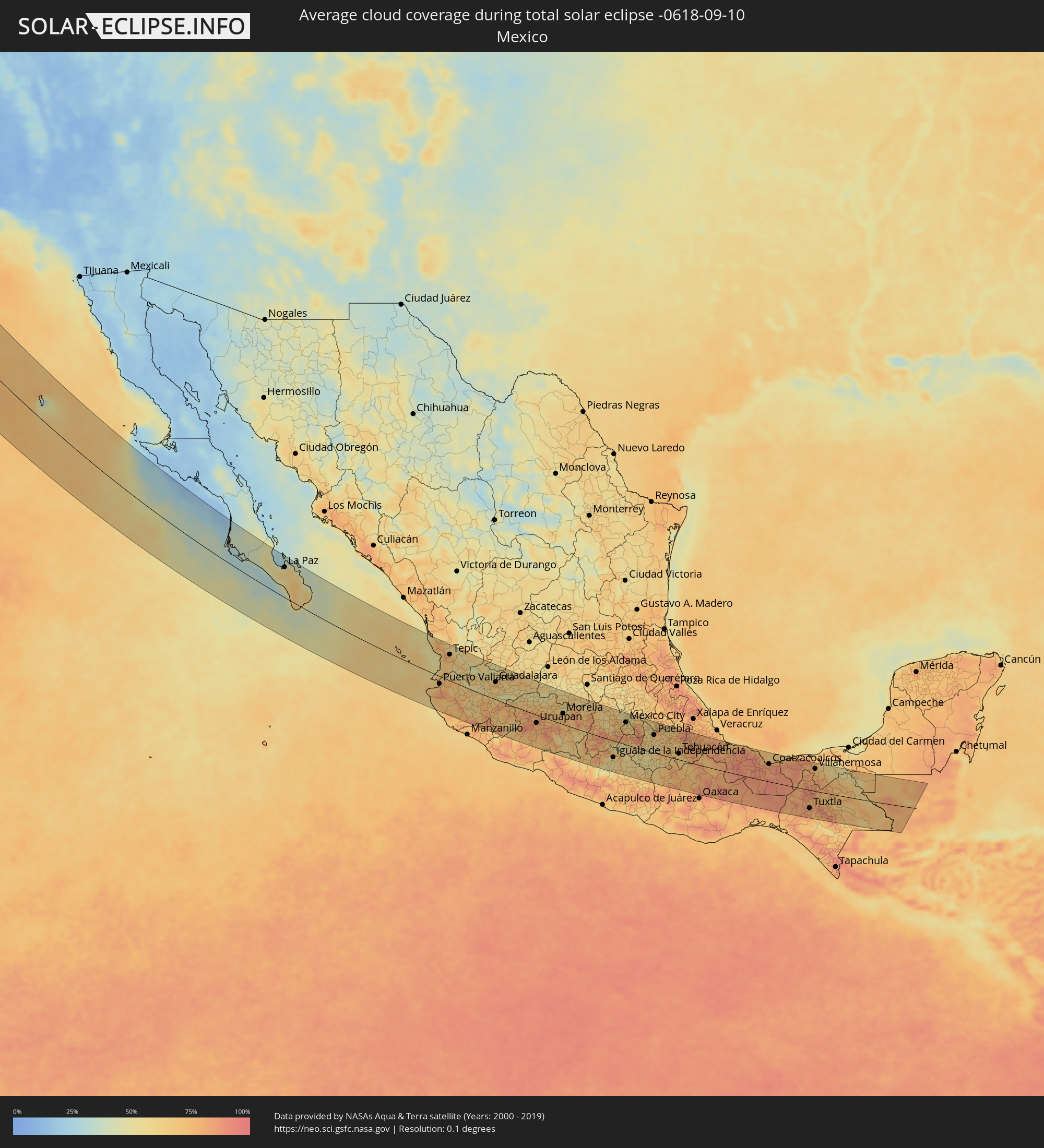 Mexico
 Guatemala
Cities inside the path of the eclipse
The following table shows all locations with a population of more than 5,000 inside the eclipse path. Cities which have more than 100,000 inhabitants are marked bold. A click at the locations opens a detailed map.
| City | Type | Eclipse duration | Local time of max. eclipse | Distance to central line | Ø Cloud coverage |
 Homer, Alaska
|
total | - | 12:18:53 UTC-10:00 | 21 km | 68% |
|
Kalifornsky, Alaska
|
total | - | 12:18:26 UTC-10:00 | 44 km | 61% |
|
Kenai, Alaska
|
total | - | 12:18:20 UTC-10:00 | 55 km | 60% |
|
Sterling, Alaska
|
total | - | 12:18:47 UTC-10:00 | 75 km | 67% |
 Ciudad Constitución, Baja California Sur
|
total | - | 16:46:16 UTC-07:05 | 97 km | 39% |
|
La Paz, Baja California Sur
|
total | - | 16:48:22 UTC-07:05 | 87 km | 57% |
|
Cabo San Lucas, Baja California Sur
|
total | - | 16:50:38 UTC-07:05 | 14 km | 50% |
|
San José del Cabo, Baja California Sur
|
total | - | 16:50:26 UTC-07:05 | 14 km | 58% |
|
Puerto Vallarta, Jalisco
|
total | - | 17:24:49 UTC-06:36 | 24 km | 74% |
|
Tepic, Nayarit
|
total | - | 16:54:26 UTC-07:05 | 81 km | 69% |
|
Autlán de Navarro, Jalisco
|
total | - | 17:26:18 UTC-06:36 | 76 km | 68% |
|
Colima, Colima
|
total | - | 17:27:13 UTC-06:36 | 104 km | 71% |
|
Ciudad Guzmán, Jalisco
|
total | - | 17:26:35 UTC-06:36 | 47 km | 69% |
|
Guadalajara, Jalisco
|
total | - | 17:25:08 UTC-06:36 | 55 km | 74% |
|
Hacienda Santa Fe, Jalisco
|
total | - | 17:25:22 UTC-06:36 | 40 km | 65% |
|
Tonalá, Jalisco
|
total | - | 17:25:14 UTC-06:36 | 57 km | 62% |
|
Ocotlán, Jalisco
|
total | - | 17:25:43 UTC-06:36 | 47 km | 59% |
|
Tepatitlán de Morelos, Jalisco
|
total | - | 17:25:01 UTC-06:36 | 95 km | 68% |
|
Sahuayo de Morelos, Michoacán
|
total | - | 17:26:11 UTC-06:36 | 18 km | 66% |
|
Apatzingán, Michoacán
|
total | - | 17:27:41 UTC-06:36 | 70 km | 74% |
|
Arandas, Jalisco
|
total | - | 17:25:16 UTC-06:36 | 99 km | 68% |
|
Zamora, Michoacán
|
total | - | 17:26:22 UTC-06:36 | 26 km | 63% |
|
Uruapan, Michoacán
|
total | - | 17:27:15 UTC-06:36 | 26 km | 79% |
|
La Piedad, Michoacán
|
total | - | 17:25:52 UTC-06:36 | 72 km | 54% |
|
Zacapú, Michoacán
|
total | - | 17:26:41 UTC-06:36 | 26 km | 72% |
|
Pátzcuaro, Michoacán
|
total | - | 17:27:09 UTC-06:36 | 1 km | 78% |
|
Valle de Santiago, Guanajuato
|
total | - | 17:25:55 UTC-06:36 | 107 km | 58% |
|
Morelia, Michoacán
|
total | - | 17:26:56 UTC-06:36 | 35 km | 69% |
|
Uriangato, Guanajuato
|
total | - | 17:26:17 UTC-06:36 | 81 km | 65% |
|
Acámbaro, Guanajuato
|
total | - | 17:26:31 UTC-06:36 | 85 km | 64% |
|
Ciudad Hidalgo, Michoacán
|
total | - | 17:27:02 UTC-06:36 | 55 km | 71% |
|
Heróica Zitácuaro, Michoacán
|
total | - | 17:27:25 UTC-06:36 | 35 km | 80% |
|
Toluca, México
|
total | - | 17:27:42 UTC-06:36 | 42 km | 64% |
|
Taxco de Alarcón, Guerrero
|
total | - | 17:28:45 UTC-06:36 | 35 km | 74% |
|
Iguala de la Independencia, Guerrero
|
total | - | 17:29:03 UTC-06:36 | 55 km | 59% |
|
Huixquilucan, México
|
total | - | 17:27:37 UTC-06:36 | 59 km | 72% |
|
Ciudad López Mateos, México
|
total | - | 17:27:18 UTC-06:36 | 86 km | 56% |
|
Cuernavaca, Morelos
|
total | - | 17:28:15 UTC-06:36 | 17 km | 67% |
|
Tepotzotlán, México
|
total | - | 17:27:07 UTC-06:36 | 101 km | 57% |
|
Tlalpan, Mexico City
|
total | - | 17:27:44 UTC-06:36 | 58 km | 69% |
|
Mexico City, Mexico City
|
total | - | 17:27:32 UTC-06:36 | 73 km | 64% |
|
Yautepec, Morelos
|
total | - | 17:28:20 UTC-06:36 | 17 km | 67% |
|
Ecatepec, México
|
total | - | 17:27:16 UTC-06:36 | 95 km | 60% |
|
Santa María Chimalhuacán, México
|
total | - | 17:27:34 UTC-06:36 | 78 km | 62% |
|
Cuautla Morelos, Morelos
|
total | - | 17:28:27 UTC-06:36 | 12 km | 68% |
|
San Miguel Xico Viejo, México
|
total | - | 17:27:47 UTC-06:36 | 62 km | 68% |
|
Chiautla, México
|
total | - | 17:27:23 UTC-06:36 | 94 km | 67% |
|
Izúcar de Matamoros, Puebla
|
total | - | 17:28:46 UTC-06:36 | 5 km | 53% |
|
San Martin Texmelucan de Labastida, Puebla
|
total | - | 17:27:48 UTC-06:36 | 79 km | 57% |
|
Atlixco, Puebla
|
total | - | 17:28:20 UTC-06:36 | 39 km | 63% |
|
Puebla, Puebla
|
total | - | 17:28:09 UTC-06:36 | 59 km | 61% |
|
Tlaxcala, Tlaxcala
|
total | - | 17:27:45 UTC-06:36 | 89 km | 66% |
|
Amozoc de Mota, Puebla
|
total | - | 17:28:09 UTC-06:36 | 65 km | 68% |
|
Huamantla, Tlaxcala
|
total | - | 17:27:47 UTC-06:36 | 97 km | 62% |
|
Ciudad de Huajuapan de León, Oaxaca
|
total | - | 17:29:53 UTC-06:36 | 61 km | 68% |
|
Tehuacán, Puebla
|
total | - | 17:28:59 UTC-06:36 | 20 km | 63% |
|
Orizaba, Veracruz
|
total | - | 17:28:27 UTC-06:36 | 70 km | 76% |
|
Córdoba, Veracruz
|
total | - | 17:28:25 UTC-06:36 | 79 km | 76% |
|
Tuxtepec, Oaxaca
|
total | - | 17:29:31 UTC-06:36 | 14 km | 79% |
|
San Andres Tuxtla, Veracruz
|
total | - | 17:29:00 UTC-06:36 | 75 km | 89% |
|
Acayucan, Veracruz
|
total | - | 17:29:40 UTC-06:36 | 28 km | 88% |
|
Minatitlan, Veracruz
|
total | - | 17:29:35 UTC-06:36 | 42 km | 84% |
|
Coatzacoalcos, Veracruz
|
total | - | 17:29:24 UTC-06:36 | 59 km | 83% |
|
Agua Dulce, Veracruz
|
total | - | 17:29:22 UTC-06:36 | 67 km | 88% |
|
Las Choapas, Veracruz
|
total | - | 17:29:40 UTC-06:36 | 43 km | 90% |
|
Cárdenas, Tabasco
|
total | - | 17:29:30 UTC-06:36 | 68 km | 83% |
|
Tuxtla, Chiapas
|
total | - | 17:31:06 UTC-06:36 | 62 km | 85% |
|
Villahermosa, Tabasco
|
total | - | 17:29:29 UTC-06:36 | 76 km | 72% |
|
San Cristóbal de las Casas, Chiapas
|
total | - | 17:31:05 UTC-06:36 | 55 km | 86% |
|
Palenque, Chiapas
|
total | - | 17:30:01 UTC-06:36 | 43 km | 73% |
|
Las Margaritas, Chiapas
|
total | - | 17:31:33 UTC-06:36 | 89 km | 68% |
 Sayaxché, Petén
|
total | - | 18:05:33 UTC-06:02 | 35 km | 74% |
|
La Libertad, Petén
|
total | - | 18:05:13 UTC-06:02 | 5 km | 79% |
|
San Benito, Petén
|
total | - | 18:05:01 UTC-06:02 | 13 km | 75% |
|
San Andrés, Petén
|
total | - | 18:04:57 UTC-06:02 | 19 km | 64% |
|
Flores, Petén
|
total | - | 18:05:00 UTC-06:02 | 14 km | 75% |
|
Santa Ana, Petén
|
total | - | 18:05:08 UTC-06:02 | 2 km | 74% |