Total solar eclipse of 08/04/-0848
| Day of week: | Sunday |
| Maximum duration of eclipse: | 05m33s |
| Maximum width of eclipse path: | 234 km |
| Saros cycle: | 51 |
| Coverage: | 100% |
| Magnitude: | 1.0684 |
| Gamma: | 0.2968 |
Wo kann man die Sonnenfinsternis vom 08/04/-0848 sehen?
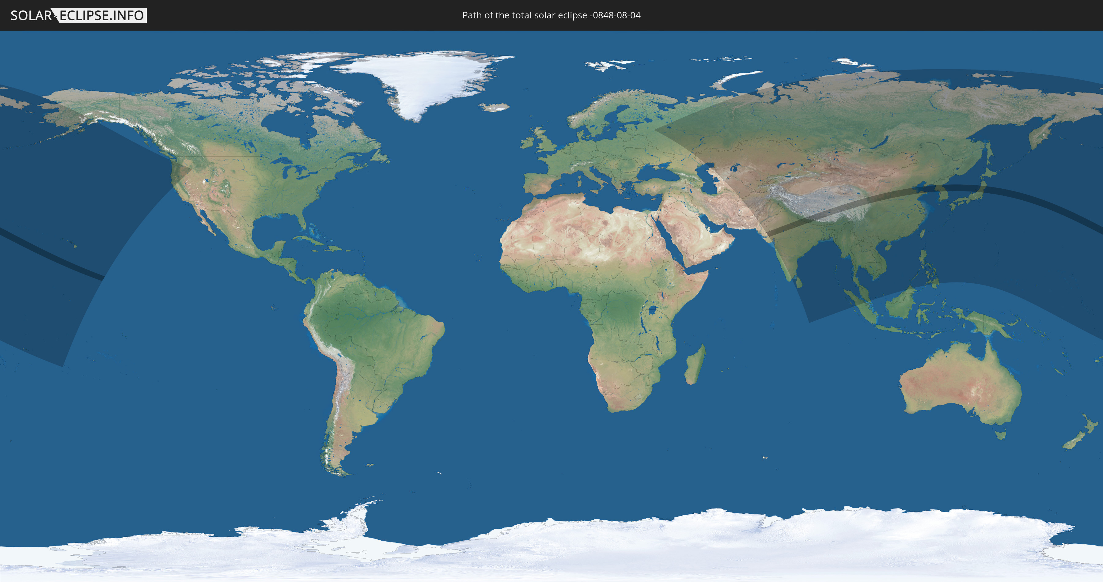
Die Sonnenfinsternis am 08/04/-0848 kann man in 44 Ländern als partielle Sonnenfinsternis beobachten.
Der Finsternispfad verläuft durch 7 Länder. Nur in diesen Ländern ist sie als total Sonnenfinsternis zu sehen.
In den folgenden Ländern ist die Sonnenfinsternis total zu sehen
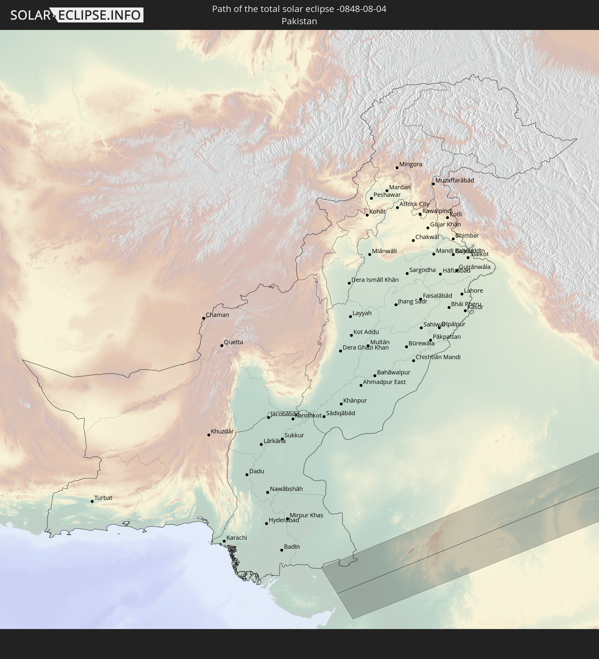 Pakistan
 India
India
 China
China
 Nepal
Nepal
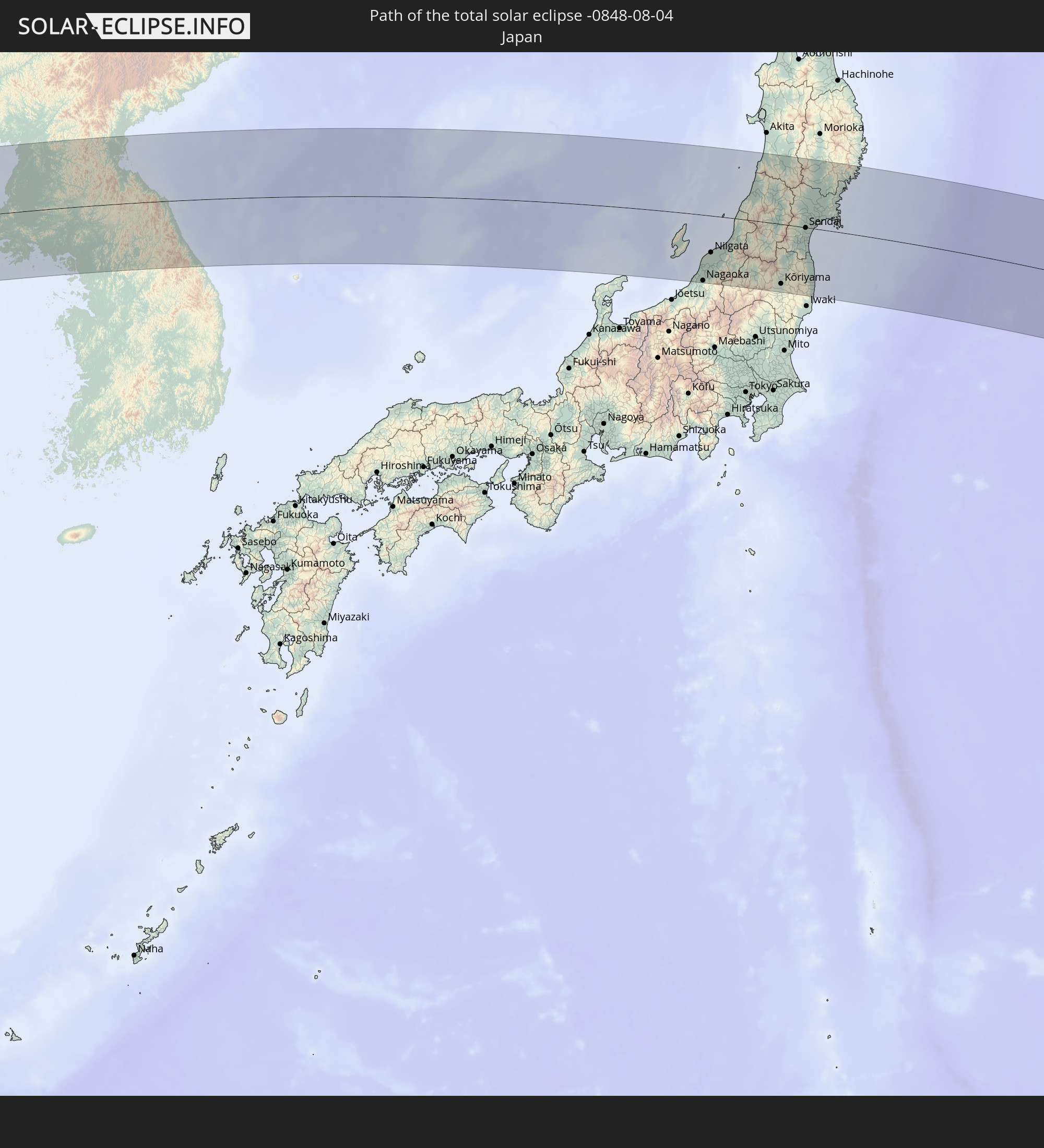 Japan
Japan
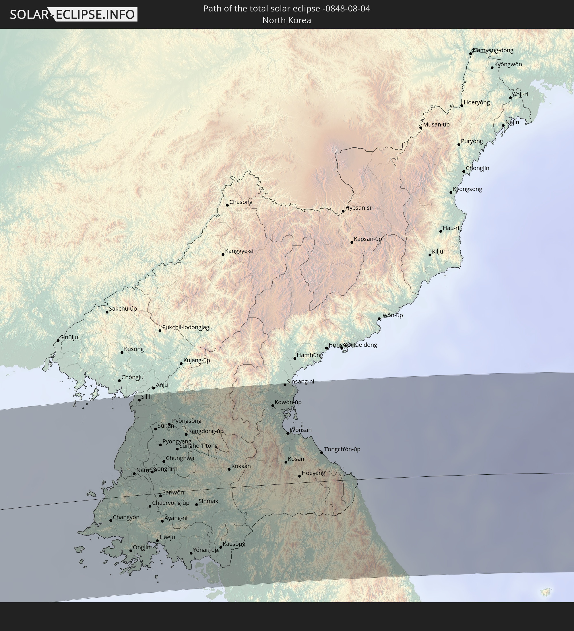 North Korea
 South Korea
In den folgenden Ländern ist die Sonnenfinsternis partiell zu sehen
 Russia
 United States
 United States Minor Outlying Islands
 Kiribati
 Samoa
Samoa
 Tokelau
 American Samoa
 Cook Islands
 Iran
Iran
 Kazakhstan
 Turkmenistan
 Uzbekistan
 Afghanistan
 Pakistan
 Tajikistan
 India
India
 Kyrgyzstan
 China
China
 Sri Lanka
 Nepal
Nepal
 Mongolia
 Bangladesh
 Bhutan
 Myanmar
 Indonesia
 Thailand
 Malaysia
 Laos
Laos
 Vietnam
 Cambodia
 Macau
Macau
 Hong Kong
 Taiwan
 Philippines
 Japan
Japan
 North Korea
 South Korea
 Palau
Palau
 Federated States of Micronesia
 Guam
Guam
 Northern Mariana Islands
 Marshall Islands
 Nauru
Nauru
 Tuvalu
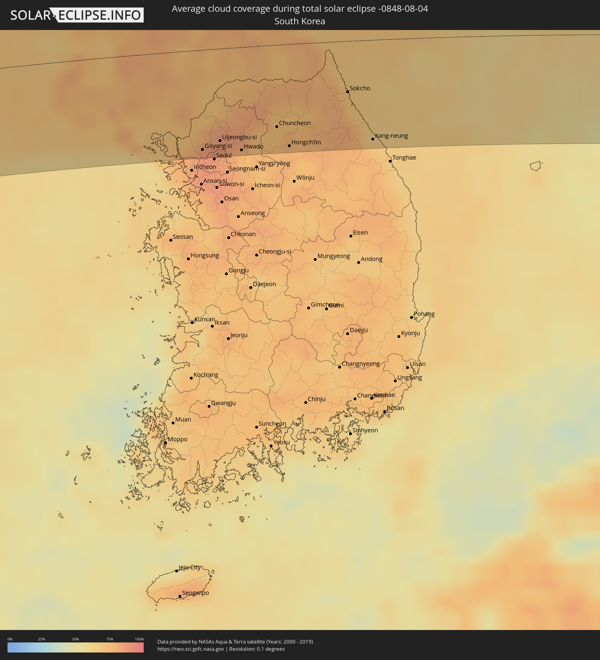
How will be the weather during the total solar eclipse on 08/04/-0848?
Where is the best place to see the total solar eclipse of 08/04/-0848?
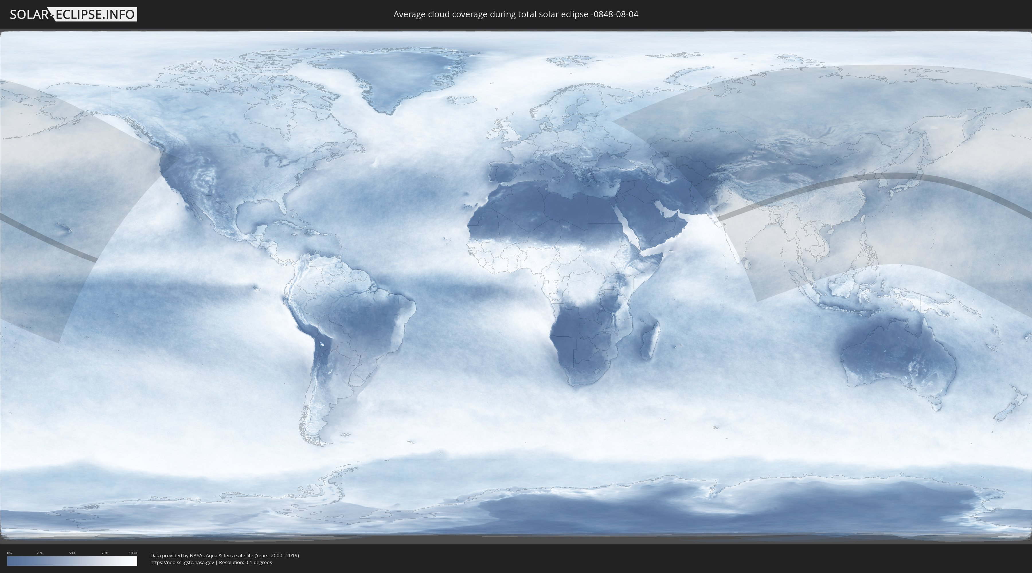
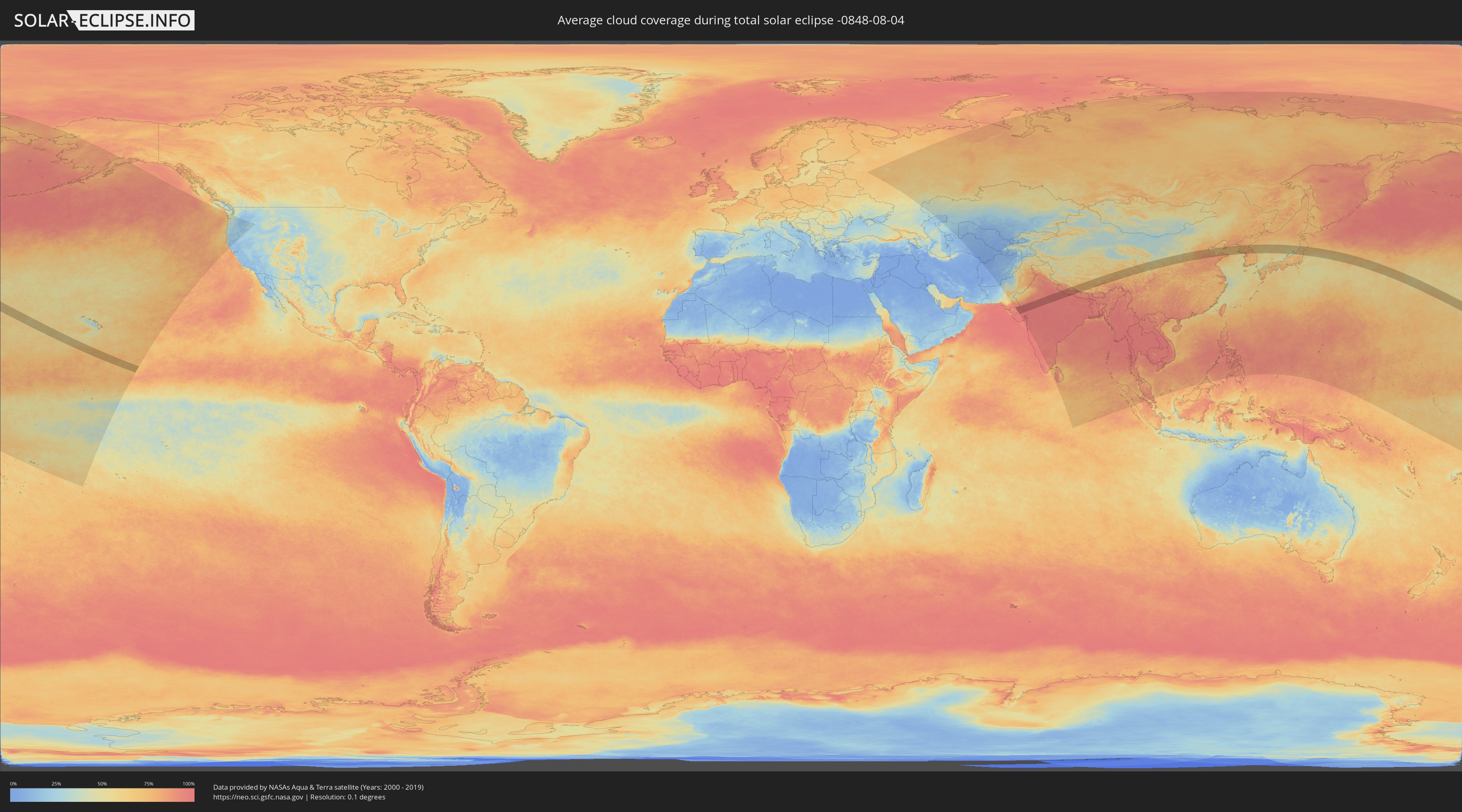
The following maps show the average cloud coverage for the day of the total solar eclipse.
With the help of these maps, it is possible to find the place along the eclipse path, which has the best
chance of a cloudless sky.
Nevertheless, you should consider local circumstances and inform about the weather of your chosen
observation site.
The data is provided by NASAs satellites
AQUA and TERRA.
The cloud maps are averaged over a period of 19 years (2000 - 2019).
Detailed country maps
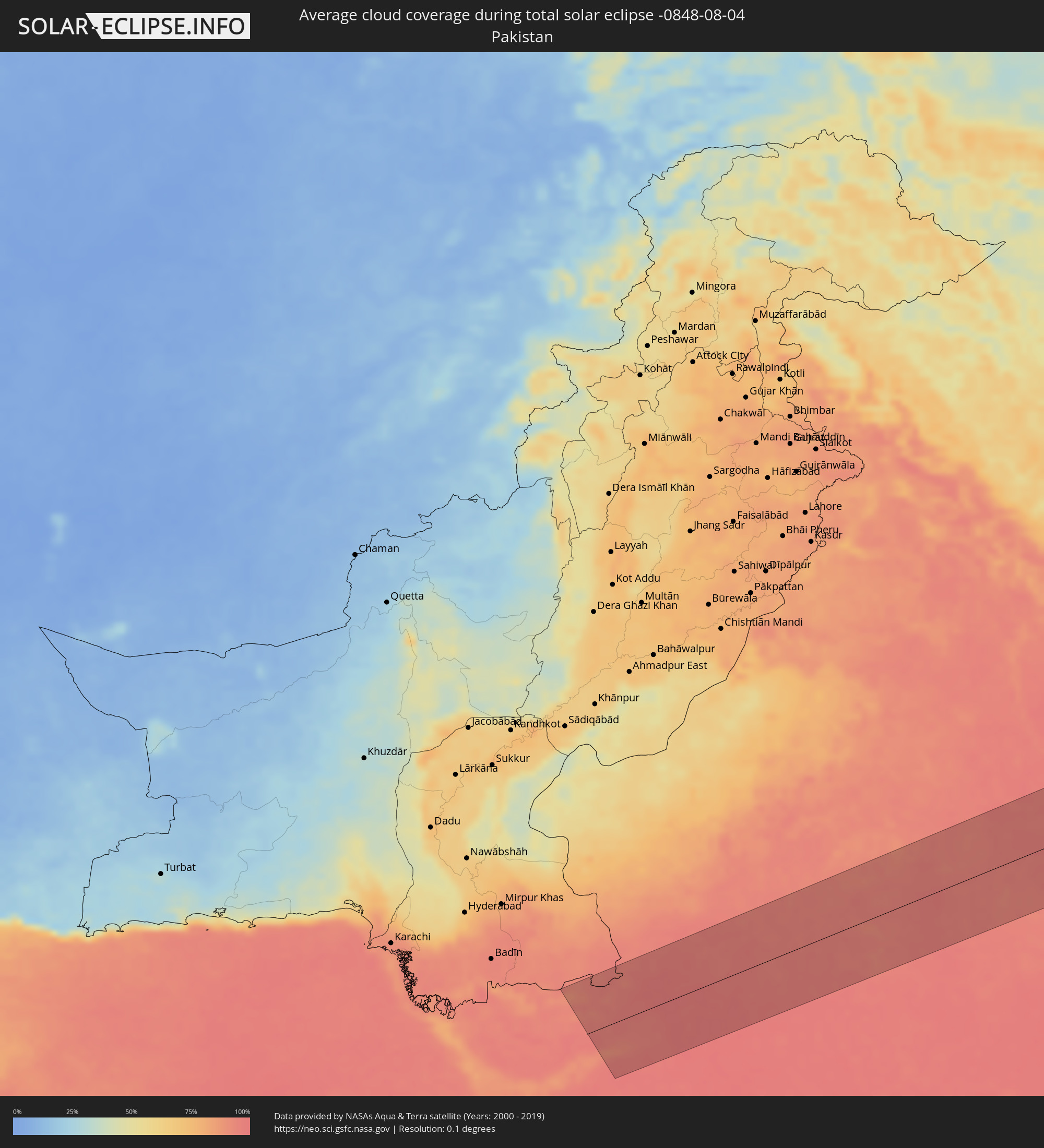 Pakistan
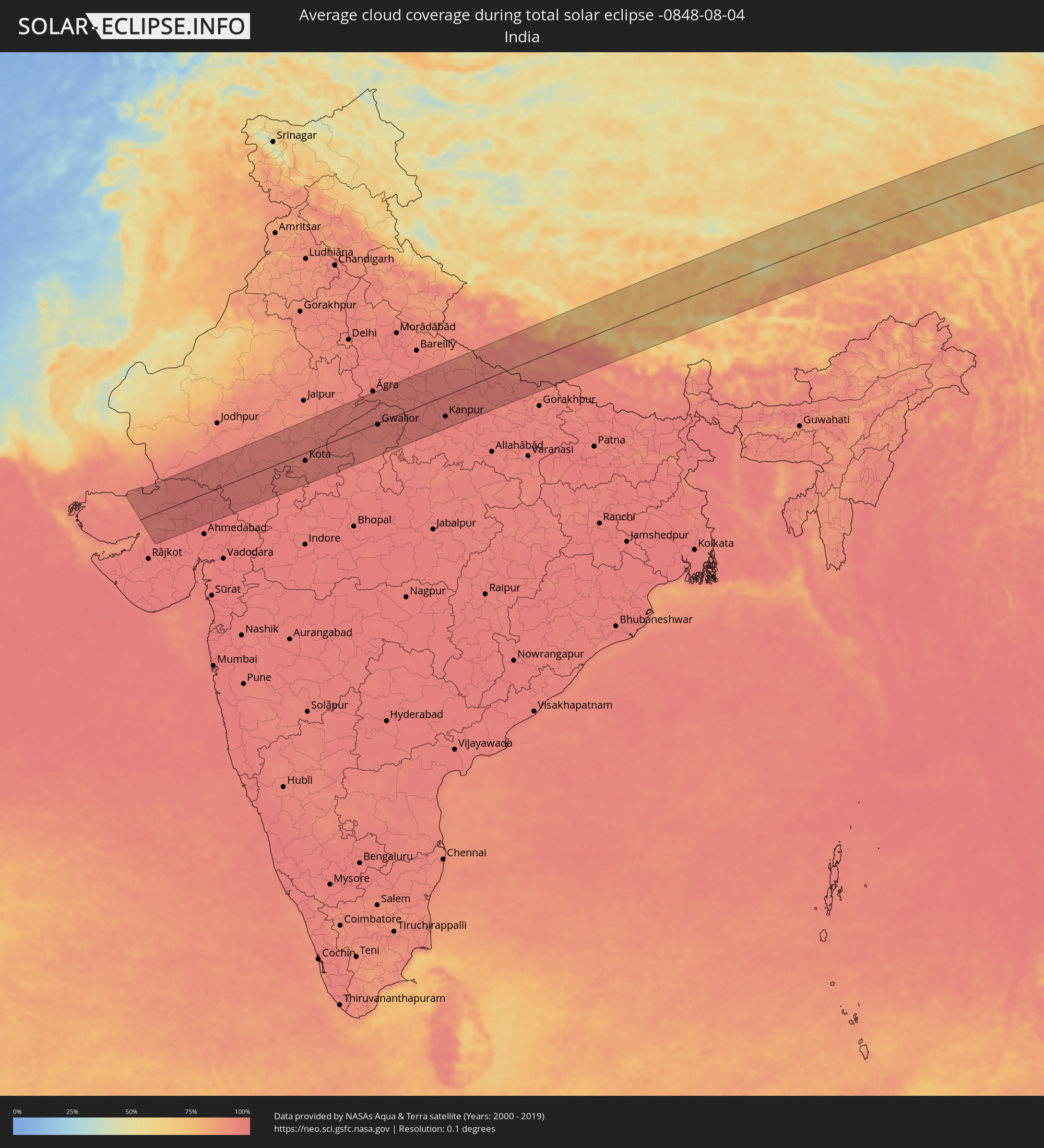 India
India
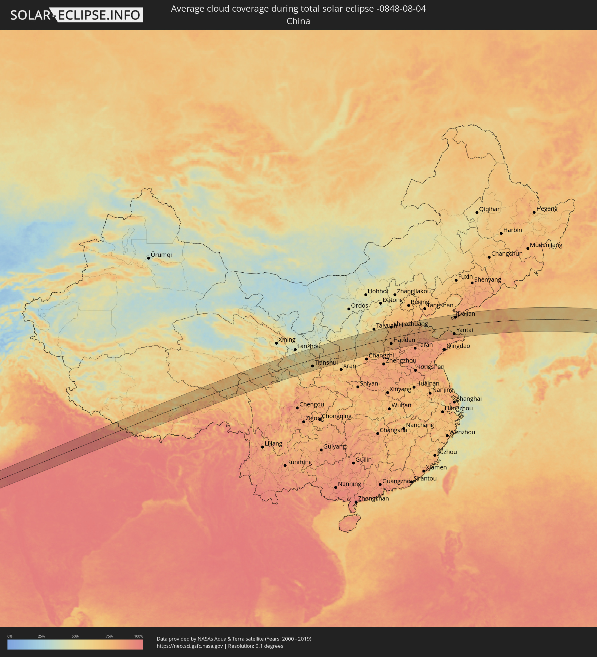 China
China
 Nepal
Nepal
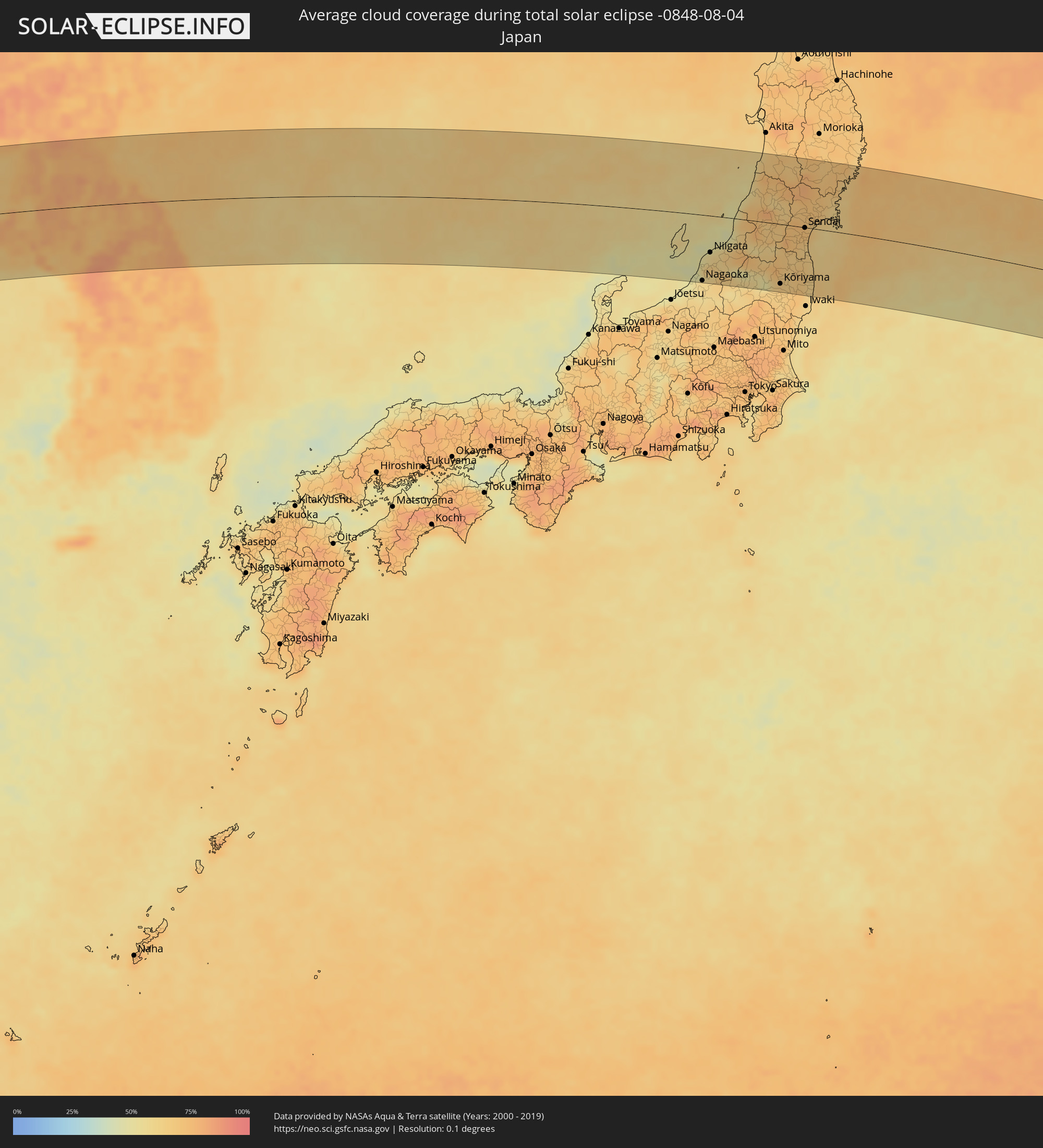 Japan
Japan
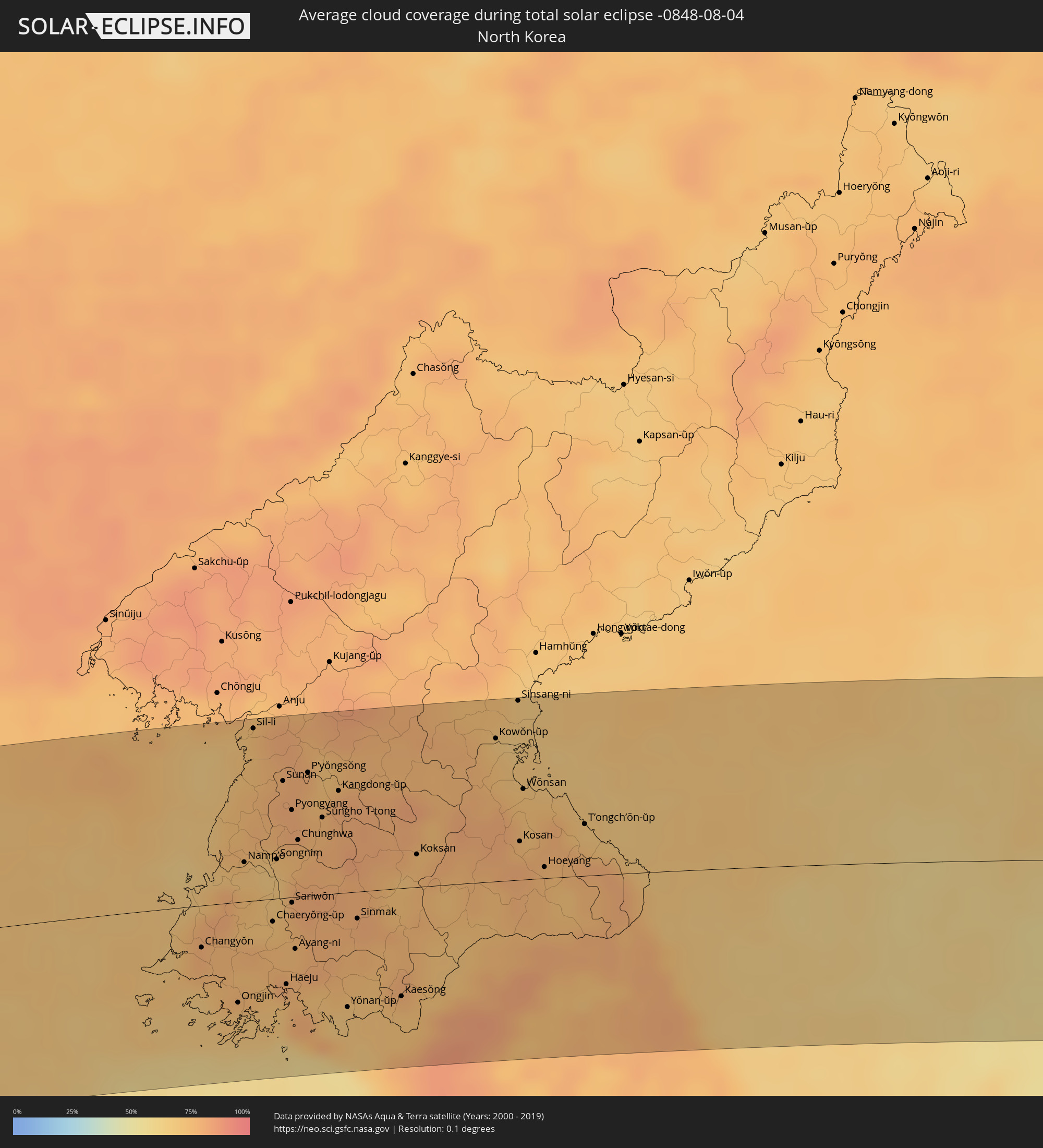 North Korea
 South Korea
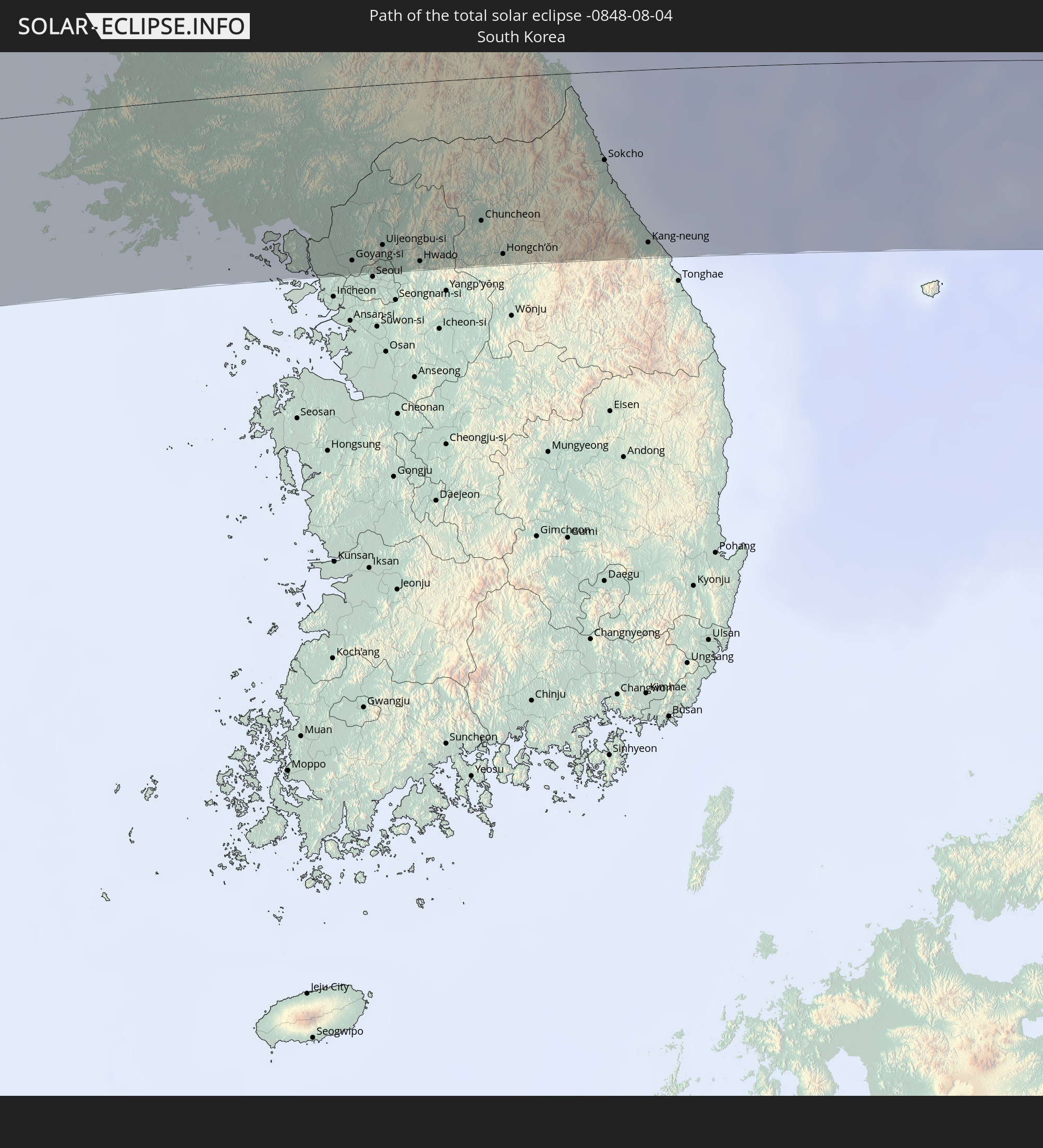
Cities inside the path of the eclipse
The following table shows all locations with a population of more than 5,000 inside the eclipse path. Cities which have more than 100,000 inhabitants are marked bold. A click at the locations opens a detailed map.
| City | Type | Eclipse duration | Local time of max. eclipse | Distance to central line | Ø Cloud coverage |
|
Pātan, Gujarat
|
total | - | 06:05:24 UTC+05:21 | 21 km | 98% |
|
Dīsa, Gujarat
|
total | - | 06:05:40 UTC+05:21 | 19 km | 98% |
|
Pālanpur, Gujarat
|
total | - | 06:05:34 UTC+05:21 | 1 km | 98% |
|
Udaipur, Rajasthan
|
total | - | 06:05:37 UTC+05:21 | 6 km | 96% |
|
Chittaurgarh, Rajasthan
|
total | - | 06:05:43 UTC+05:21 | 9 km | 95% |
|
Bhīlwāra, Rajasthan
|
total | - | 06:06:03 UTC+05:21 | 38 km | 94% |
|
Būndi, Rajasthan
|
total | - | 06:06:00 UTC+05:21 | 9 km | 95% |
|
Tonk, Rajasthan
|
total | - | 06:06:33 UTC+05:21 | 79 km | 93% |
|
Kota, Rajasthan
|
total | - | 06:05:47 UTC+05:21 | 25 km | 95% |
|
Sawāi Mādhopur, Rajasthan
|
total | - | 06:06:23 UTC+05:21 | 43 km | 96% |
|
Bārān, Rajasthan
|
total | - | 06:05:39 UTC+05:21 | 59 km | 97% |
|
Gangāpur, Rajasthan
|
total | - | 06:06:42 UTC+05:21 | 75 km | 94% |
|
Hindaun, Rajasthan
|
total | - | 06:06:53 UTC+05:21 | 90 km | 95% |
|
Shivpuri, Madhya Pradesh
|
total | - | 06:05:49 UTC+05:21 | 69 km | 95% |
|
Dhaulpur, Rajasthan
|
total | - | 06:06:49 UTC+05:21 | 54 km | 95% |
|
Morena, Madhya Pradesh
|
total | - | 06:06:39 UTC+05:21 | 29 km | 96% |
|
Gwalior, Madhya Pradesh
|
total | - | 06:06:26 UTC+05:21 | 5 km | 95% |
|
Fīrozābād, Uttar Pradesh
|
total | - | 06:07:10 UTC+05:21 | 81 km | 96% |
|
Datia, Madhya Pradesh
|
total | - | 06:05:59 UTC+05:21 | 73 km | 94% |
|
Shikohābād, Uttar Pradesh
|
total | - | 06:07:08 UTC+05:21 | 70 km | 96% |
|
Bhind, Madhya Pradesh
|
total | - | 06:06:41 UTC+05:21 | 7 km | 96% |
|
Etāwah, Uttar Pradesh
|
total | - | 06:06:51 UTC+05:21 | 19 km | 95% |
|
Mainpuri, Uttar Pradesh
|
total | - | 06:07:14 UTC+05:21 | 66 km | 96% |
|
Orai, Uttar Pradesh
|
total | - | 06:06:13 UTC+05:21 | 78 km | 96% |
|
Farrukhābād, Uttar Pradesh
|
total | - | 06:07:22 UTC+05:21 | 62 km | 95% |
|
Hardoī, Uttar Pradesh
|
total | - | 06:07:23 UTC+05:21 | 41 km | 96% |
|
Kanpur, Uttar Pradesh
|
total | - | 06:06:37 UTC+05:21 | 63 km | 95% |
|
Unnāo, Uttar Pradesh
|
total | - | 06:06:41 UTC+05:21 | 59 km | 97% |
|
Sītāpur, Uttar Pradesh
|
total | - | 06:07:32 UTC+05:21 | 38 km | 96% |
|
Lakhīmpur, Uttar Pradesh
|
total | - | 06:07:52 UTC+05:21 | 74 km | 96% |
|
Lucknow, Uttar Pradesh
|
total | - | 06:06:57 UTC+05:21 | 46 km | 97% |
|
Gulariyā, Mid Western
|
total | - | 06:28:15 UTC+05:41 | 83 km | 94% |
|
Bahraigh, Uttar Pradesh
|
total | - | 06:07:36 UTC+05:21 | 5 km | 96% |
|
Nepalgunj, Mid Western
|
total | - | 06:28:07 UTC+05:41 | 53 km | 95% |
|
Gondā City, Uttar Pradesh
|
total | - | 06:07:15 UTC+05:21 | 54 km | 96% |
|
Fyzābād, Uttar Pradesh
|
total | - | 06:06:58 UTC+05:21 | 98 km | 93% |
|
Tulsīpur, Mid Western
|
total | - | 06:28:15 UTC+05:41 | 36 km | 93% |
|
Besisahar
|
total | - | 06:28:21 UTC+05:41 | 43 km | 95% |
|
Butwāl, Western Region
|
total | - | 06:28:00 UTC+05:41 | 51 km | 96% |
|
Bhairāhawā, Western Region
|
total | - | 06:27:49 UTC+05:41 | 71 km | 96% |
|
Tānsen, Western Region
|
total | - | 06:28:09 UTC+05:41 | 37 km | 92% |
|
Bāglung, Western Region
|
total | - | 06:28:31 UTC+05:41 | 3 km | 88% |
|
Wāling, Western Region
|
total | - | 06:28:17 UTC+05:41 | 33 km | 92% |
|
Bhattarai Danda, Western Region
|
total | - | 06:28:13 UTC+05:41 | 50 km | 92% |
|
Pokhara, Western Region
|
total | - | 06:28:34 UTC+05:41 | 11 km | 90% |
|
Bharatpur, Central Region
|
total | - | 06:28:07 UTC+05:41 | 89 km | 93% |
|
Tianshui, Gansu
|
total | - | 09:05:30 UTC+08:00 | 68 km | 59% |
|
Pingliang, Gansu
|
total | - | 09:07:26 UTC+08:00 | 10 km | 57% |
|
Tongchuan, Shaanxi
|
total | - | 09:09:33 UTC+08:00 | 100 km | 66% |
|
Linfen, Shanxi
|
total | - | 09:13:25 UTC+08:00 | 49 km | 62% |
|
Yuci, Shanxi
|
total | - | 09:16:28 UTC+08:00 | 97 km | 54% |
|
Yangquan, Shanxi
|
total | - | 09:17:42 UTC+08:00 | 99 km | 60% |
|
Hecun, Hebei
|
total | - | 09:17:11 UTC+08:00 | 56 km | 76% |
|
Linshui, Hebei
|
total | - | 09:17:12 UTC+08:00 | 69 km | 76% |
|
Anyang, Henan
|
total | - | 09:17:09 UTC+08:00 | 109 km | 81% |
|
Handan, Hebei
|
total | - | 09:17:43 UTC+08:00 | 56 km | 76% |
|
Shijiazhuang, Hebei
|
total | - | 09:19:04 UTC+08:00 | 101 km | 77% |
|
Xingtai, Hebei
|
total | - | 09:18:11 UTC+08:00 | 6 km | 78% |
|
Luancheng, Hebei
|
total | - | 09:19:09 UTC+08:00 | 80 km | 76% |
|
Xinji, Hebei
|
total | - | 09:19:55 UTC+08:00 | 72 km | 79% |
|
Hengshui, Hebei
|
total | - | 09:20:27 UTC+08:00 | 44 km | 76% |
|
Qingnian, Shandong
|
total | - | 09:19:40 UTC+08:00 | 53 km | 80% |
|
Liaocheng, Shandong
|
total | - | 09:19:42 UTC+08:00 | 100 km | 84% |
|
Dezhou, Shandong
|
total | - | 09:21:03 UTC+08:00 | 2 km | 82% |
|
Cangzhou, Hebei
|
total | - | 09:22:36 UTC+08:00 | 87 km | 77% |
|
Jinan, Shandong
|
total | - | 09:21:22 UTC+08:00 | 95 km | 85% |
|
Mingshui, Shandong
|
total | - | 09:22:09 UTC+08:00 | 99 km | 84% |
|
Zhoucun, Shandong
|
total | - | 09:22:42 UTC+08:00 | 93 km | 83% |
|
Binzhou, Shandong
|
total | - | 09:23:28 UTC+08:00 | 36 km | 82% |
|
Nanding, Shandong
|
total | - | 09:23:01 UTC+08:00 | 104 km | 81% |
|
Zibo, Shandong
|
total | - | 09:23:03 UTC+08:00 | 100 km | 84% |
|
Shengli, Shandong
|
total | - | 09:24:16 UTC+08:00 | 33 km | 80% |
|
Weichanglu, Shandong
|
total | - | 09:26:17 UTC+08:00 | 86 km | 79% |
|
Luofeng, Shandong
|
total | - | 09:27:11 UTC+08:00 | 72 km | 81% |
|
Dengzhou, Shandong
|
total | - | 09:28:04 UTC+08:00 | 28 km | 79% |
|
Yantai, Shandong
|
total | - | 09:28:56 UTC+08:00 | 73 km | 84% |
|
Dalian, Liaoning
|
total | - | 09:30:15 UTC+08:00 | 83 km | 78% |
|
Jinzhou, Liaoning
|
total | - | 09:30:34 UTC+08:00 | 102 km | 79% |
|
Tianfu, Shandong
|
total | - | 09:29:45 UTC+08:00 | 112 km | 84% |
|
Weihai, Shandong
|
total | - | 09:30:05 UTC+08:00 | 78 km | 80% |
|
Changyŏn, Hwanghae-namdo
|
total | - | 09:58:41 UTC+08:23 | 27 km | 79% |
|
Ongjin, Hwanghae-namdo
|
total | - | 09:58:58 UTC+08:23 | 64 km | 70% |
|
Namp’o, P'yŏngan-namdo
|
total | - | 09:59:31 UTC+08:23 | 25 km | 70% |
|
Yonggang-ŭp, P'yŏngan-namdo
|
total | - | 09:59:37 UTC+08:23 | 38 km | 75% |
|
Sil-li, P'yŏngan-namdo
|
total | - | 10:00:05 UTC+08:23 | 108 km | 74% |
|
Anak, Hwanghae-bukto
|
total | - | 09:59:32 UTC+08:23 | 1 km | 72% |
|
Pyŏksŏng-ŭp, Hwanghae-namdo
|
total | - | 09:59:23 UTC+08:23 | 53 km | 72% |
|
Chaeryŏng-ŭp, Hwanghae-namdo
|
total | - | 09:59:41 UTC+08:23 | 14 km | 71% |
|
Songnim, Hwanghae-bukto
|
total | - | 09:59:57 UTC+08:23 | 25 km | 69% |
|
Sunan, Pyongyang
|
total | - | 10:00:17 UTC+08:23 | 74 km | 79% |
|
Haeju, Hwanghae-namdo
|
total | - | 09:59:40 UTC+08:23 | 55 km | 73% |
|
Pyongyang, Pyongyang
|
total | - | 10:00:18 UTC+08:23 | 55 km | 80% |
|
Sariwŏn, Hwanghae-bukto
|
total | - | 10:00:00 UTC+08:23 | 3 km | 77% |
|
Hwangju-ŭp, Hwanghae-bukto
|
total | - | 10:00:08 UTC+08:23 | 15 km | 77% |
|
Ayang-ni, Hwanghae-namdo
|
total | - | 09:59:54 UTC+08:23 | 33 km | 77% |
|
Hŭkkyo-ri, Hwanghae-bukto
|
total | - | 10:00:14 UTC+08:23 | 29 km | 75% |
|
Chunghwa, Pyongyang
|
total | - | 10:00:17 UTC+08:23 | 36 km | 76% |
|
P’yŏngsŏng, P'yŏngan-namdo
|
total | - | 10:00:38 UTC+08:23 | 78 km | 76% |
|
Sŭngho 1-tong, Pyongyang
|
total | - | 10:00:40 UTC+08:23 | 49 km | 77% |
|
Kangdong-ŭp, Pyongyang
|
total | - | 10:00:58 UTC+08:23 | 65 km | 80% |
|
Yŏnan-ŭp, Hwanghae-namdo
|
total | - | 10:00:24 UTC+08:23 | 73 km | 70% |
|
Sinmak, Hwanghae-bukto
|
total | - | 10:00:48 UTC+08:23 | 17 km | 78% |
|
Ganghwa-gun, Incheon
|
total | - | 10:05:46 UTC+08:27 | 93 km | 76% |
|
Kaesŏng, Hwanghae-namdo
|
total | - | 10:01:09 UTC+08:23 | 69 km | 77% |
|
Koksan, Hwanghae-bukto
|
total | - | 10:01:47 UTC+08:23 | 21 km | 74% |
|
Munsan, Gyeonggi-do
|
total | - | 10:06:23 UTC+08:27 | 83 km | 77% |
|
Goyang-si, Gyeonggi-do
|
total | - | 10:06:22 UTC+08:27 | 105 km | 86% |
|
Sangsŏng-ni, P'yŏngan-namdo
|
total | - | 10:02:23 UTC+08:23 | 62 km | 76% |
|
Uijeongbu-si, Gyeonggi-do
|
total | - | 10:06:48 UTC+08:27 | 97 km | 86% |
|
Yangju, Gyeonggi-do
|
total | - | 10:06:53 UTC+08:27 | 87 km | 85% |
|
Guri-si, Gyeonggi-do
|
total | - | 10:06:54 UTC+08:27 | 114 km | 82% |
|
Namyangju, Gyeonggi-do
|
total | - | 10:07:04 UTC+08:27 | 110 km | 79% |
|
Kowŏn-ŭp, Hamgyŏng-namdo
|
total | - | 10:03:09 UTC+08:23 | 90 km | 73% |
|
Hwado, Gyeonggi-do
|
total | - | 10:07:15 UTC+08:27 | 109 km | 76% |
|
Sinsang-ni, Hamgyŏng-namdo
|
total | - | 10:03:33 UTC+08:23 | 113 km | 69% |
|
Kosan, Kangwŏn-do
|
total | - | 10:03:11 UTC+08:23 | 24 km | 76% |
|
Wŏnsan, Kangwŏn-do
|
total | - | 10:03:22 UTC+08:23 | 57 km | 72% |
|
Gapyeong, Gyeonggi-do
|
total | - | 10:07:43 UTC+08:27 | 90 km | 71% |
|
Anbyŏn-ŭp, Kangwŏn-do
|
total | - | 10:03:28 UTC+08:23 | 44 km | 72% |
|
Hoeyang, Kangwŏn-do
|
total | - | 10:03:26 UTC+08:23 | 7 km | 75% |
|
Hwacheon, Gangwon-do
|
total | - | 10:08:13 UTC+08:27 | 61 km | 74% |
|
Chuncheon, Gangwon-do
|
total | - | 10:08:09 UTC+08:27 | 86 km | 74% |
|
Hongch’ŏn, Gangwon-do
|
total | - | 10:08:21 UTC+08:27 | 108 km | 77% |
|
T’ongch’ŏn-ŭp, Kangwŏn-do
|
total | - | 10:04:06 UTC+08:23 | 33 km | 70% |
|
Yanggu, Gangwon-do
|
total | - | 10:08:44 UTC+08:27 | 62 km | 72% |
|
Kosong, Gangwon-do
|
total | - | 10:09:46 UTC+08:27 | 34 km | 68% |
|
Sokcho, Gangwon-do
|
total | - | 10:09:55 UTC+08:27 | 54 km | 71% |
|
Kang-neung, Gangwon-do
|
total | - | 10:10:18 UTC+08:27 | 105 km | 69% |
|
Nagaoka, Niigata
|
total | - | 11:02:55 UTC+09:00 | 113 km | 59% |
|
Sanjō, Niigata
|
total | - | 11:03:06 UTC+09:00 | 93 km | 60% |
|
Niigata, Niigata
|
total | - | 11:03:11 UTC+09:00 | 63 km | 57% |
|
Kamo, Niigata
|
total | - | 11:03:17 UTC+09:00 | 87 km | 65% |
|
Kameda-honchō, Niigata
|
total | - | 11:03:25 UTC+09:00 | 63 km | 61% |
|
Gosen, Niigata
|
total | - | 11:03:33 UTC+09:00 | 78 km | 65% |
|
Shibata, Niigata
|
total | - | 11:03:53 UTC+09:00 | 53 km | 62% |
|
Tsuruoka, Yamagata
|
total | - | 11:04:48 UTC+09:00 | 38 km | 68% |
|
Sakata, Yamagata
|
total | - | 11:04:50 UTC+09:00 | 60 km | 62% |
|
Kitakata, Fukushima
|
total | - | 11:05:05 UTC+09:00 | 80 km | 58% |
|
Yonezawa, Yamagata
|
total | - | 11:05:34 UTC+09:00 | 49 km | 64% |
|
Kaminoyama, Yamagata
|
total | - | 11:05:51 UTC+09:00 | 20 km | 68% |
|
Shinjō, Yamagata
|
total | - | 11:05:48 UTC+09:00 | 47 km | 62% |
|
Yamagata, Yamagata
|
total | - | 11:06:02 UTC+09:00 | 10 km | 72% |
|
Kōriyama, Fukushima
|
total | - | 11:06:15 UTC+09:00 | 102 km | 66% |
|
Higashine, Yamagata
|
total | - | 11:06:04 UTC+09:00 | 13 km | 68% |
|
Nihommatsu, Fukushima
|
total | - | 11:06:19 UTC+09:00 | 81 km | 67% |
|
Fukushima, Fukushima
|
total | - | 11:06:21 UTC+09:00 | 62 km | 68% |
|
Yuzawa, Akita
|
total | - | 11:06:08 UTC+09:00 | 94 km | 69% |
|
Yokotemachi, Akita
|
total | - | 11:06:12 UTC+09:00 | 111 km | 67% |
|
Shiroishi, Miyagi
|
total | - | 11:06:37 UTC+09:00 | 33 km | 68% |
|
Kakuda, Miyagi
|
total | - | 11:06:58 UTC+09:00 | 34 km | 65% |
|
Watari, Miyagi
|
total | - | 11:07:07 UTC+09:00 | 26 km | 63% |
|
Iwanuma, Miyagi
|
total | - | 11:07:07 UTC+09:00 | 19 km | 64% |
|
Sendai, Miyagi
|
total | - | 11:07:06 UTC+09:00 | 1 km | 71% |
|
Furukawa, Miyagi
|
total | - | 11:07:13 UTC+09:00 | 34 km | 72% |
|
Rifu, Miyagi
|
total | - | 11:07:19 UTC+09:00 | 8 km | 68% |
|
Shiogama, Miyagi
|
total | - | 11:07:26 UTC+09:00 | 7 km | 68% |
|
Kitakami, Iwate
|
total | - | 11:07:23 UTC+09:00 | 114 km | 70% |
|
Mizusawa, Iwate
|
total | - | 11:07:27 UTC+09:00 | 98 km | 72% |
|
Ichinoseki, Iwate
|
total | - | 11:07:30 UTC+09:00 | 74 km | 72% |
|
Yamoto, Miyagi
|
total | - | 11:07:48 UTC+09:00 | 21 km | 63% |
|
Ishinomaki, Miyagi
|
total | - | 11:07:59 UTC+09:00 | 21 km | 63% |
|
Ōfunato, Iwate
|
total | - | 11:08:41 UTC+09:00 | 99 km | 65% |