Total solar eclipse of 03/25/-1251
| Day of week: | Thursday |
| Maximum duration of eclipse: | 01m38s |
| Maximum width of eclipse path: | 104 km |
| Saros cycle: | 19 |
| Coverage: | 100% |
| Magnitude: | 1.0214 |
| Gamma: | -0.7255 |
Wo kann man die Sonnenfinsternis vom 03/25/-1251 sehen?
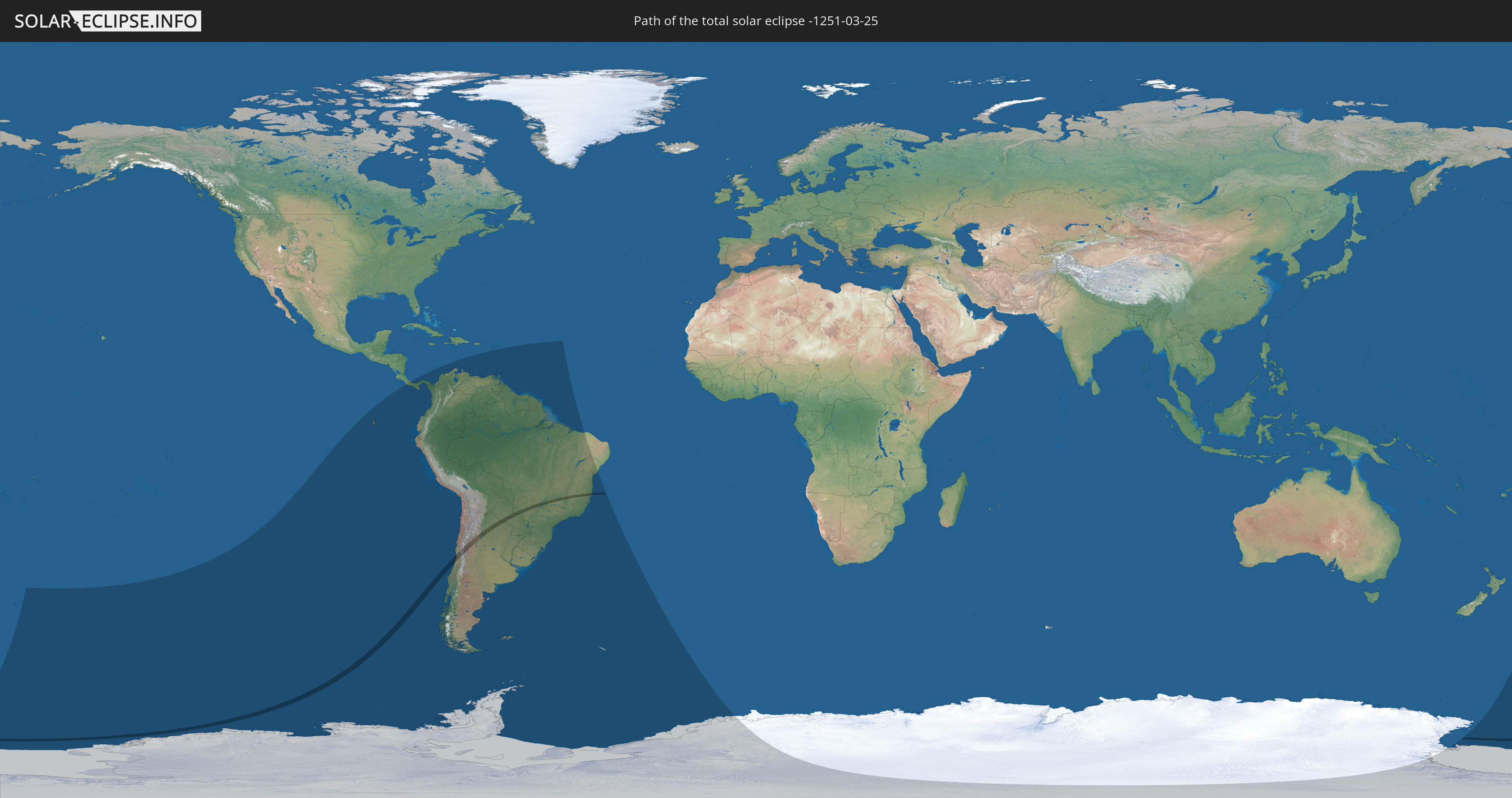
Die Sonnenfinsternis am 03/25/-1251 kann man in 28 Ländern als partielle Sonnenfinsternis beobachten.
Der Finsternispfad verläuft durch 4 Länder. Nur in diesen Ländern ist sie als total Sonnenfinsternis zu sehen.
In den folgenden Ländern ist die Sonnenfinsternis total zu sehen
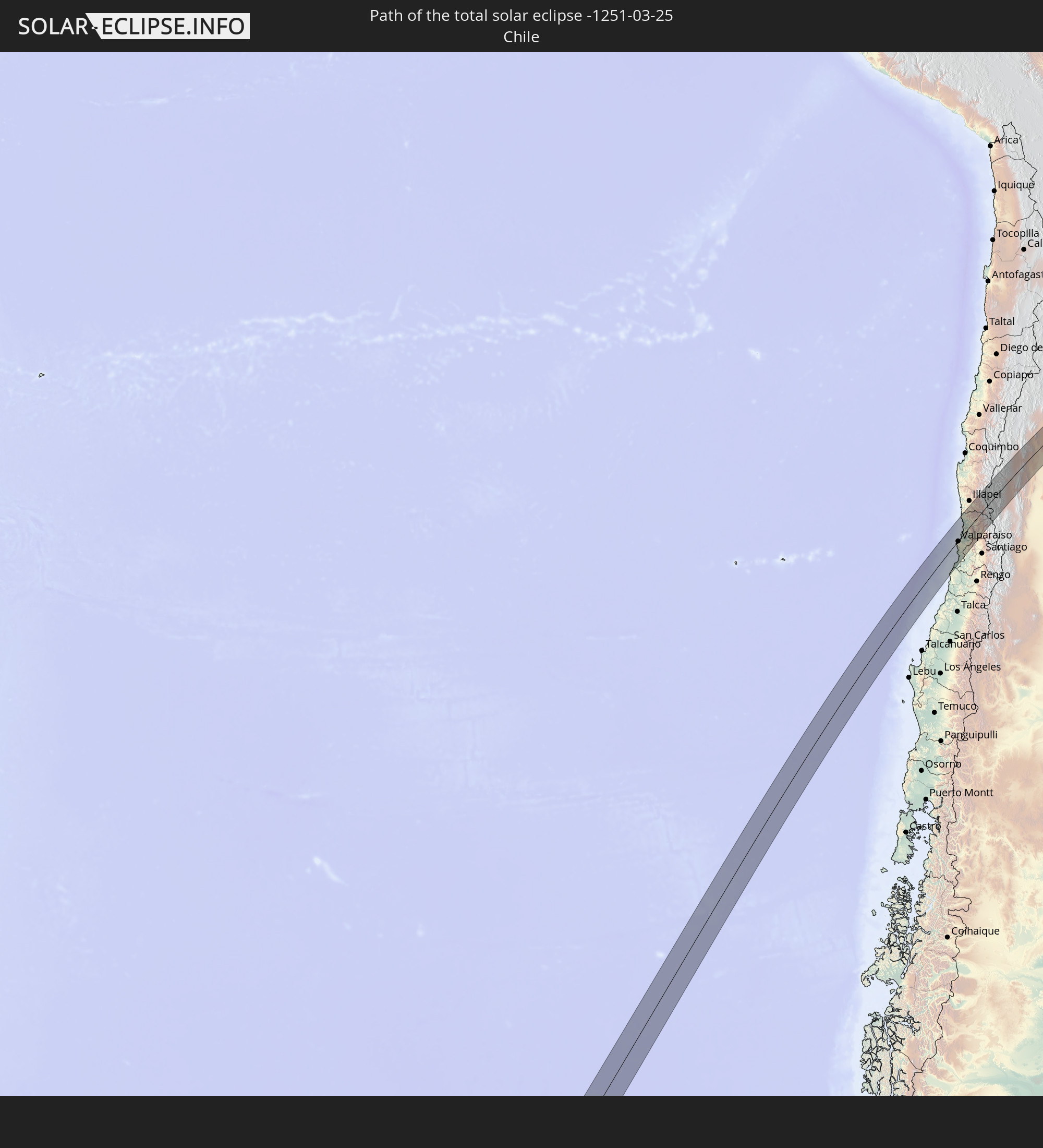 Chile
Chile
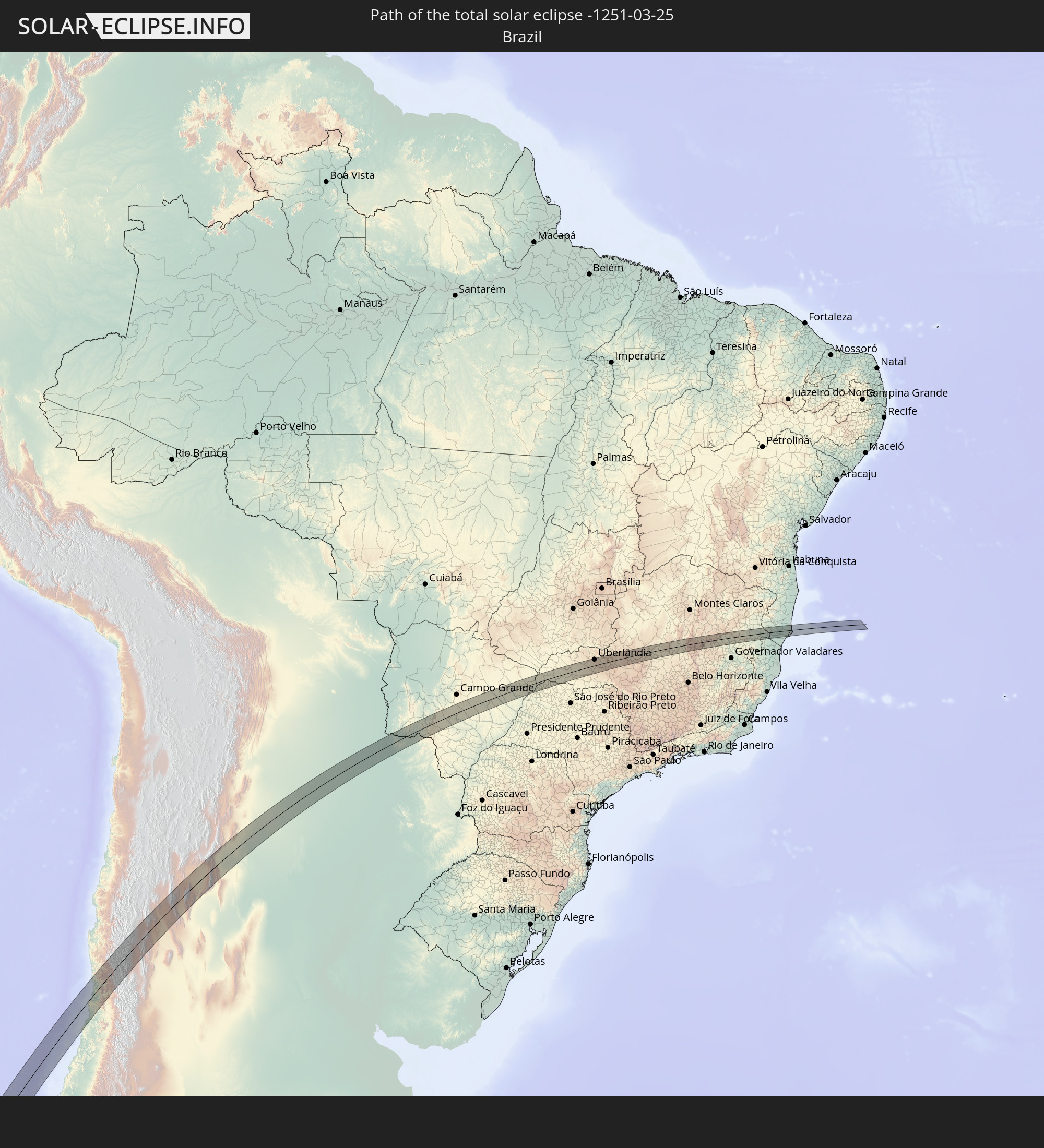 Brazil
 Argentina
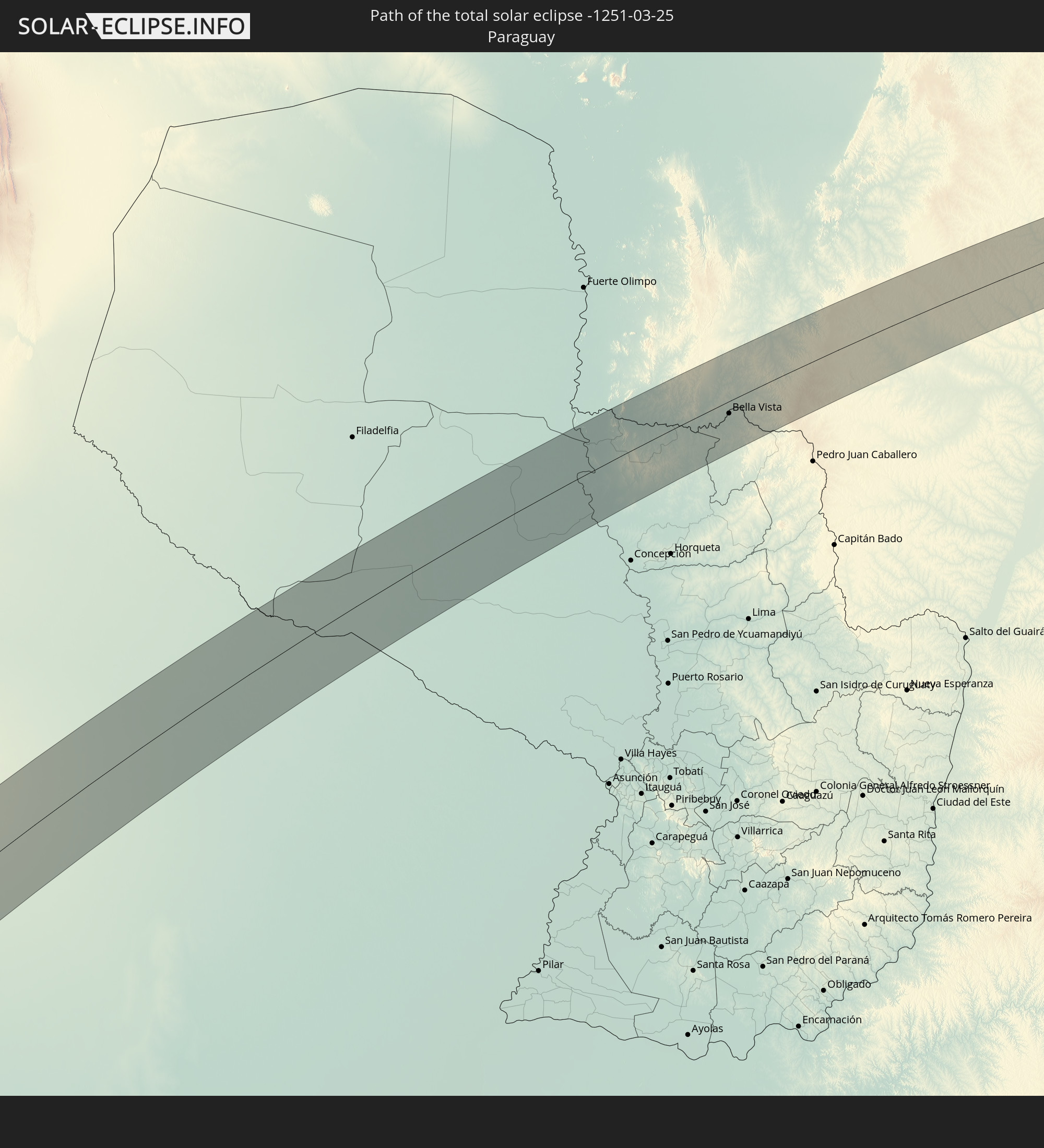 Paraguay
In den folgenden Ländern ist die Sonnenfinsternis partiell zu sehen
 Antarctica
 Chile
Chile
 Ecuador
 Costa Rica
 Panama
 Colombia
 Peru
Peru
 Brazil
 Argentina
 Venezuela
 Aruba
Aruba
 Bolivia
 Paraguay
 Montserrat
 Trinidad and Tobago
 Guadeloupe
 Grenada
 Dominica
 Saint Vincent and the Grenadines
 Falkland Islands
 Guyana
 Martinique
 Saint Lucia
 Barbados
 Uruguay
 Suriname
 French Guiana
 South Georgia and the South Sandwich Islands
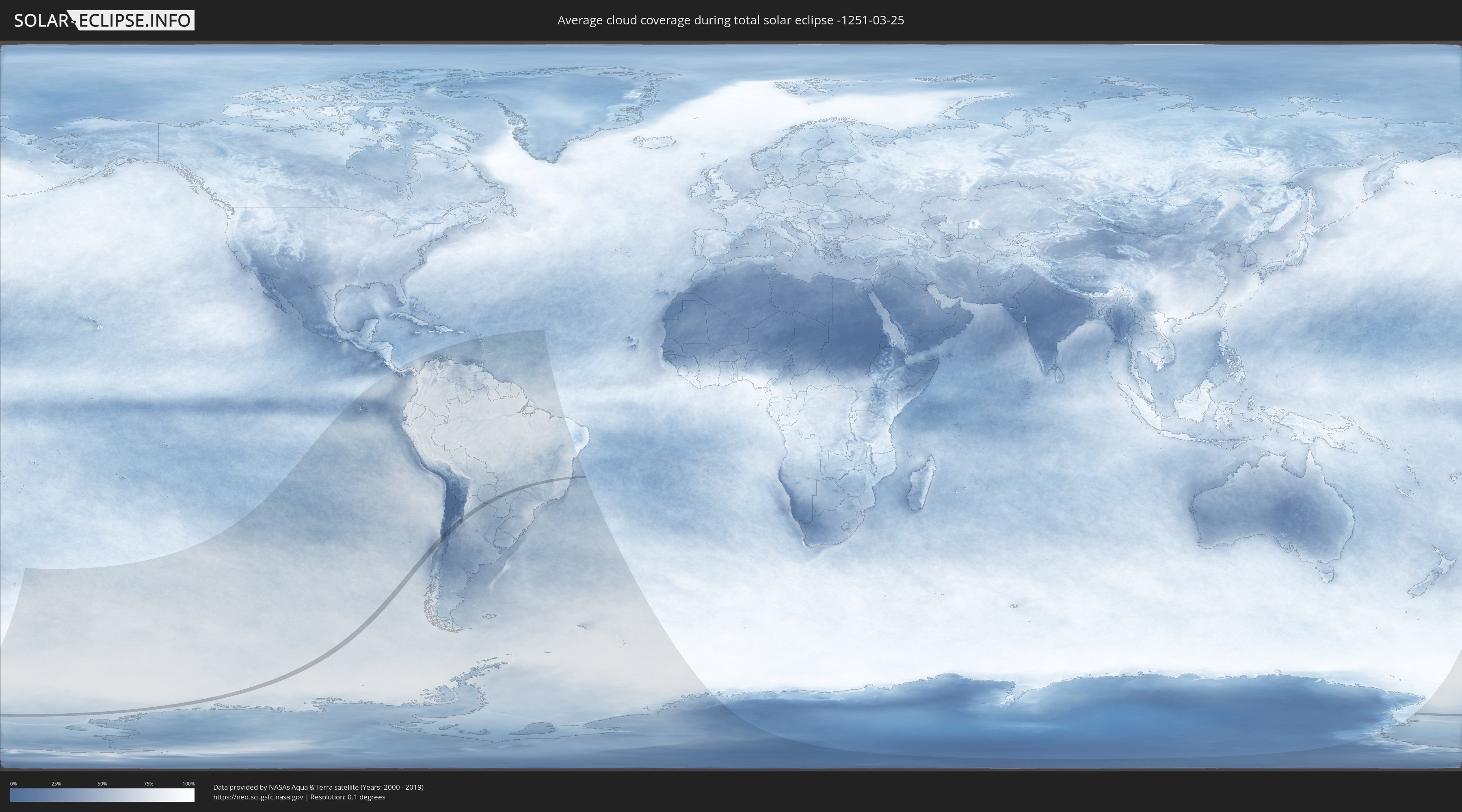
How will be the weather during the total solar eclipse on 03/25/-1251?
Where is the best place to see the total solar eclipse of 03/25/-1251?
The following maps show the average cloud coverage for the day of the total solar eclipse.
With the help of these maps, it is possible to find the place along the eclipse path, which has the best
chance of a cloudless sky.
Nevertheless, you should consider local circumstances and inform about the weather of your chosen
observation site.
The data is provided by NASAs satellites
AQUA and TERRA.
The cloud maps are averaged over a period of 19 years (2000 - 2019).

Detailed country maps
 Chile
Chile
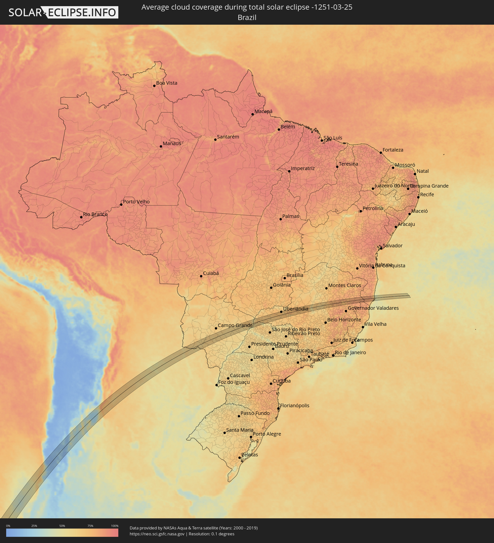 Brazil
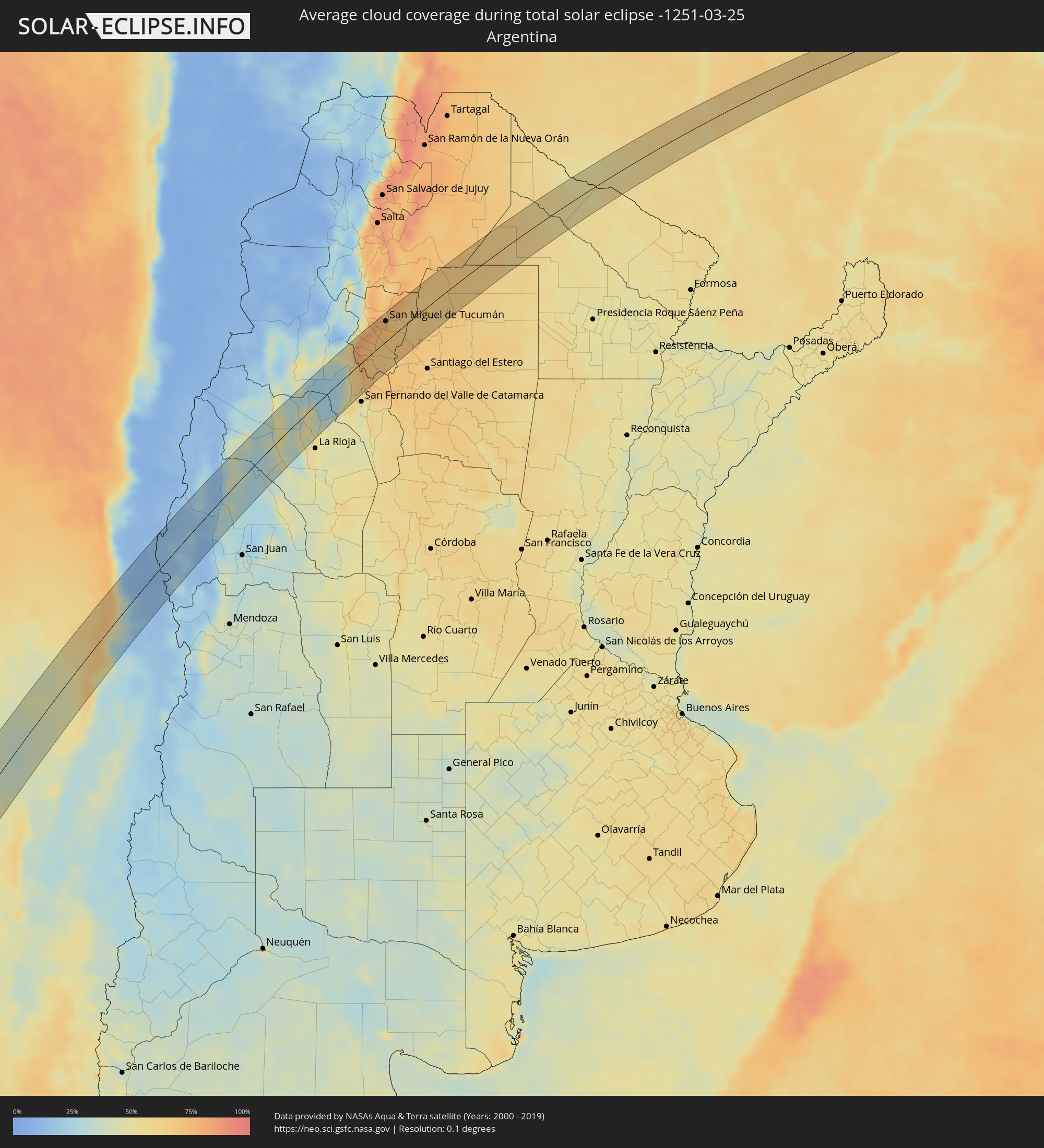 Argentina
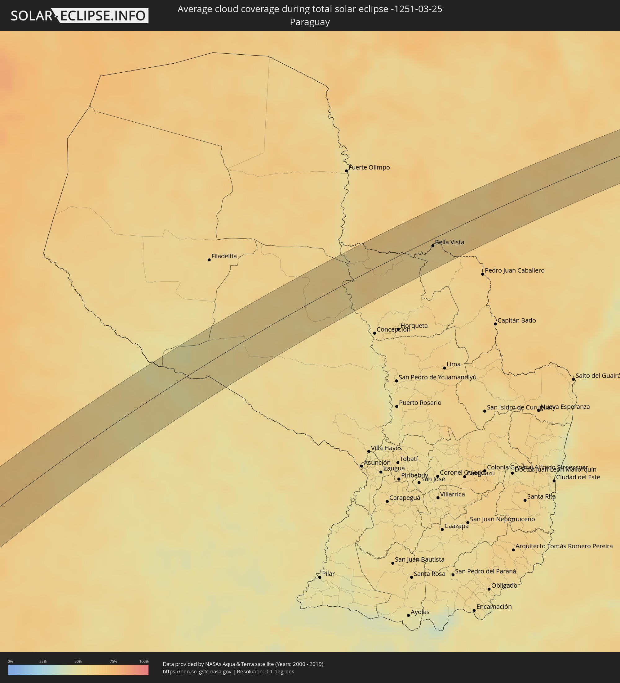 Paraguay
Cities inside the path of the eclipse
The following table shows all locations with a population of more than 5,000 inside the eclipse path. Cities which have more than 100,000 inhabitants are marked bold. A click at the locations opens a detailed map.
| City | Type | Eclipse duration | Local time of max. eclipse | Distance to central line | Ø Cloud coverage |
|
Valparaíso, Valparaíso
|
total | - | 15:07:32 UTC-04:42 | 2 km | 47% |
|
Cartagena, Valparaíso
|
total | - | 15:06:30 UTC-04:42 | 39 km | 45% |
|
San Antonio, Valparaíso
|
total | - | 15:06:25 UTC-04:42 | 42 km | 45% |
|
Viña del Mar, Valparaíso
|
total | - | 15:07:39 UTC-04:42 | 7 km | 47% |
|
Quilpué, Valparaíso
|
total | - | 15:07:43 UTC-04:42 | 16 km | 36% |
|
Villa Alemana, Valparaíso
|
total | - | 15:07:48 UTC-04:42 | 21 km | 36% |
|
Limache, Valparaíso
|
total | - | 15:07:58 UTC-04:42 | 27 km | 32% |
|
Quillota, Valparaíso
|
total | - | 15:08:15 UTC-04:42 | 19 km | 29% |
|
La Ligua, Valparaíso
|
total | - | 15:09:10 UTC-04:42 | 11 km | 29% |
|
Hacienda La Calera, Valparaíso
|
total | - | 15:08:30 UTC-04:42 | 14 km | 29% |
|
Salamanca, Coquimbo
|
total | - | 15:10:49 UTC-04:42 | 40 km | 12% |
|
Llaillay, Valparaíso
|
total | - | 15:08:39 UTC-04:42 | 37 km | 19% |
|
San Felipe, Valparaíso
|
total | - | 15:09:05 UTC-04:42 | 47 km | 15% |
|
Calingasta, San Juan Province
|
total | - | 15:39:20 UTC-04:16 | 39 km | 11% |
|
San José de Jáchal, San Juan Province
|
total | - | 15:42:13 UTC-04:16 | 4 km | 33% |
|
Chilecito, La Rioja Province
|
total | - | 15:45:38 UTC-04:16 | 6 km | 37% |
|
Arauco, La Rioja Province
|
total | - | 15:47:29 UTC-04:16 | 7 km | 31% |
|
Andalgalá, Catamarca Province
|
total | - | 15:49:53 UTC-04:16 | 41 km | 34% |
|
Aguilares, Tucumán Province
|
total | - | 15:50:52 UTC-04:16 | 9 km | 73% |
|
La Cocha, Tucumán Province
|
total | - | 15:50:13 UTC-04:16 | 23 km | 70% |
|
Los Altos, Catamarca Province
|
total | - | 15:49:44 UTC-04:16 | 50 km | 68% |
|
Monteros, Tucumán Province
|
total | - | 15:51:30 UTC-04:16 | 24 km | 72% |
|
Graneros, Tucumán Province
|
total | - | 15:50:35 UTC-04:16 | 21 km | 71% |
|
Famaillá, Tucumán Province
|
total | - | 15:51:48 UTC-04:16 | 27 km | 72% |
|
Simoca, Tucumán Province
|
total | - | 15:51:26 UTC-04:16 | 7 km | 70% |
|
Yerba Buena, Tucumán Province
|
total | - | 15:52:21 UTC-04:16 | 42 km | 76% |
|
Bella Vista, Tucumán Province
|
total | - | 15:51:56 UTC-04:16 | 22 km | 73% |
|
Tafí Viejo, Tucumán Province
|
total | - | 15:52:34 UTC-04:16 | 45 km | 78% |
|
San Miguel de Tucumán, Tucumán Province
|
total | - | 15:52:25 UTC-04:16 | 35 km | 74% |
|
Alderetes, Tucumán Province
|
total | - | 15:52:31 UTC-04:16 | 30 km | 72% |
|
Termas de Río Hondo, Santiago del Estero Province
|
total | - | 15:51:25 UTC-04:16 | 45 km | 64% |
|
Taco Pozo, Chaco Province
|
total | - | 15:56:26 UTC-04:16 | 19 km | 68% |
|
Bela Vista, Mato Grosso do Sul
|
total | - | 16:33:52 UTC-03:50 | 8 km | 58% |
|
Bella Vista, Amambay
|
total | - | 16:33:49 UTC-03:50 | 11 km | 58% |
|
Jardim, Mato Grosso do Sul
|
total | - | 16:47:24 UTC-03:38 | 38 km | 60% |
|
Guia Lopes da Laguna, Mato Grosso do Sul
|
total | - | 16:47:27 UTC-03:38 | 39 km | 60% |
|
Maracaju, Mato Grosso do Sul
|
total | - | 16:47:41 UTC-03:38 | 17 km | 63% |
|
Paranaíba, Mato Grosso do Sul
|
total | - | 16:52:49 UTC-03:38 | 34 km | 64% |
|
Aparecida do Taboado, Mato Grosso do Sul
|
total | - | 16:52:10 UTC-03:38 | 12 km | 54% |
|
Santa Fé do Sul, São Paulo
|
total | - | 17:24:02 UTC-03:06 | 31 km | 61% |
|
Iturama, Minas Gerais
|
total | - | 17:25:06 UTC-03:06 | 3 km | 63% |
|
Campina Verde, Minas Gerais
|
total | - | 17:25:39 UTC-03:06 | 5 km | 66% |
|
Prata, Minas Gerais
|
total | - | 17:26:12 UTC-03:06 | 4 km | 69% |
|
Uberlândia, Minas Gerais
|
total | - | 17:27:01 UTC-03:06 | 28 km | 72% |
|
Monte Carmelo, Minas Gerais
|
total | - | 17:27:32 UTC-03:06 | 28 km | 74% |
|
Patrocínio, Minas Gerais
|
total | - | 17:27:20 UTC-03:06 | 8 km | 71% |
|
Patos de Minas, Minas Gerais
|
total | - | 17:28:01 UTC-03:06 | 20 km | 75% |
|
Lagoa Formosa, Minas Gerais
|
total | - | 17:27:44 UTC-03:06 | 4 km | 71% |
|
Carmo do Paranaíba, Minas Gerais
|
total | - | 17:27:24 UTC-03:06 | 31 km | 73% |
|
Corinto, Minas Gerais
|
total | - | 17:28:44 UTC-03:06 | 3 km | 63% |
|
Diamantina, Minas Gerais
|
total | - | 17:29:04 UTC-03:06 | 5 km | 74% |
|
Itamarandiba, Minas Gerais
|
total | - | 17:29:45 UTC-03:06 | 25 km | 79% |
|
Santa Maria do Suaçuí, Minas Gerais
|
total | - | 17:29:19 UTC-03:06 | 19 km | 82% |
|
Malacacheta, Minas Gerais
|
total | - | 17:29:52 UTC-03:06 | 14 km | 80% |
|
Itambacuri, Minas Gerais
|
total | - | 17:29:37 UTC-03:06 | 13 km | 80% |
|
Teófilo Otoni, Minas Gerais
|
total | - | 17:29:54 UTC-03:06 | 3 km | 80% |
|
Carlos Chagas, Minas Gerais
|
total | - | 17:30:10 UTC-03:06 | 10 km | 81% |
|
Nanuque, Minas Gerais
|
total | - | 17:30:00 UTC-03:06 | 10 km | 82% |