Annular solar eclipse of 01/01/0903
| Day of week: | Monday |
| Maximum duration of eclipse: | 08m45s |
| Maximum width of eclipse path: | 331 km |
| Saros cycle: | 104 |
| Coverage: | 92% |
| Magnitude: | 0.9202 |
| Gamma: | -0.4032 |
Wo kann man die Sonnenfinsternis vom 01/01/0903 sehen?
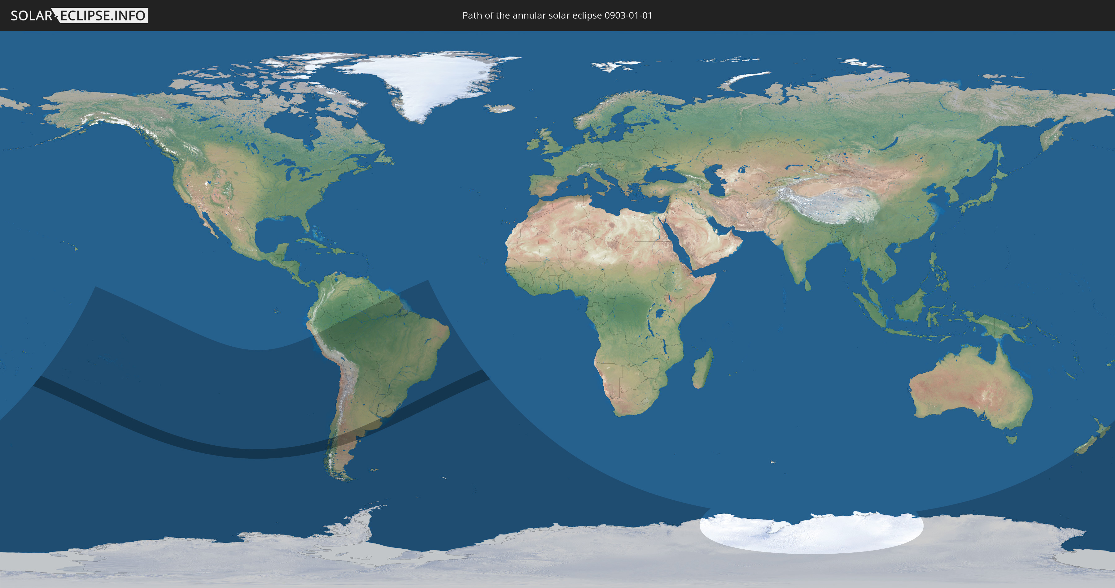
Die Sonnenfinsternis am 01/01/0903 kann man in 22 Ländern als partielle Sonnenfinsternis beobachten.
Der Finsternispfad verläuft durch 4 Länder. Nur in diesen Ländern ist sie als annular Sonnenfinsternis zu sehen.
In den folgenden Ländern ist die Sonnenfinsternis annular zu sehen
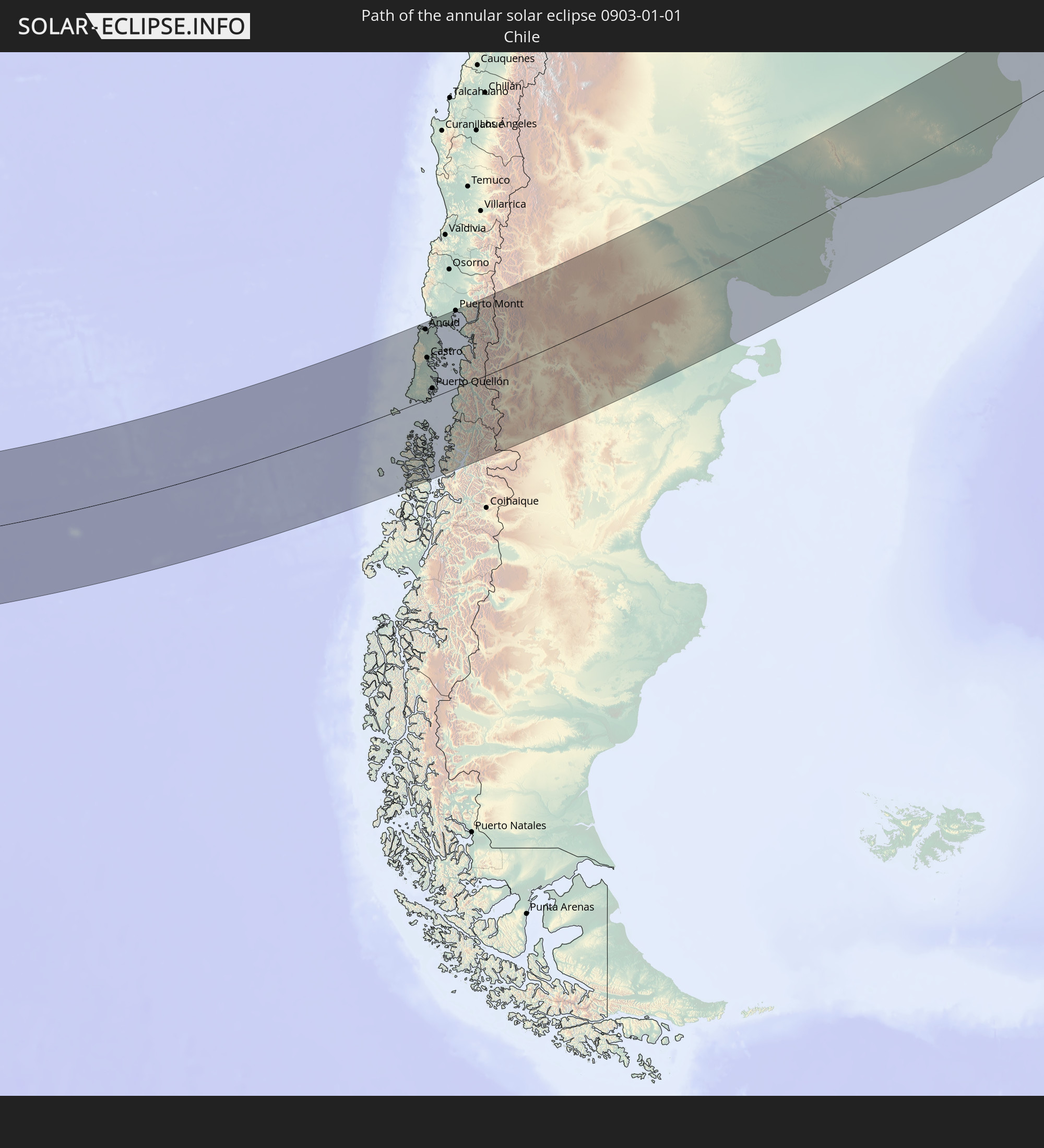 Chile
Chile
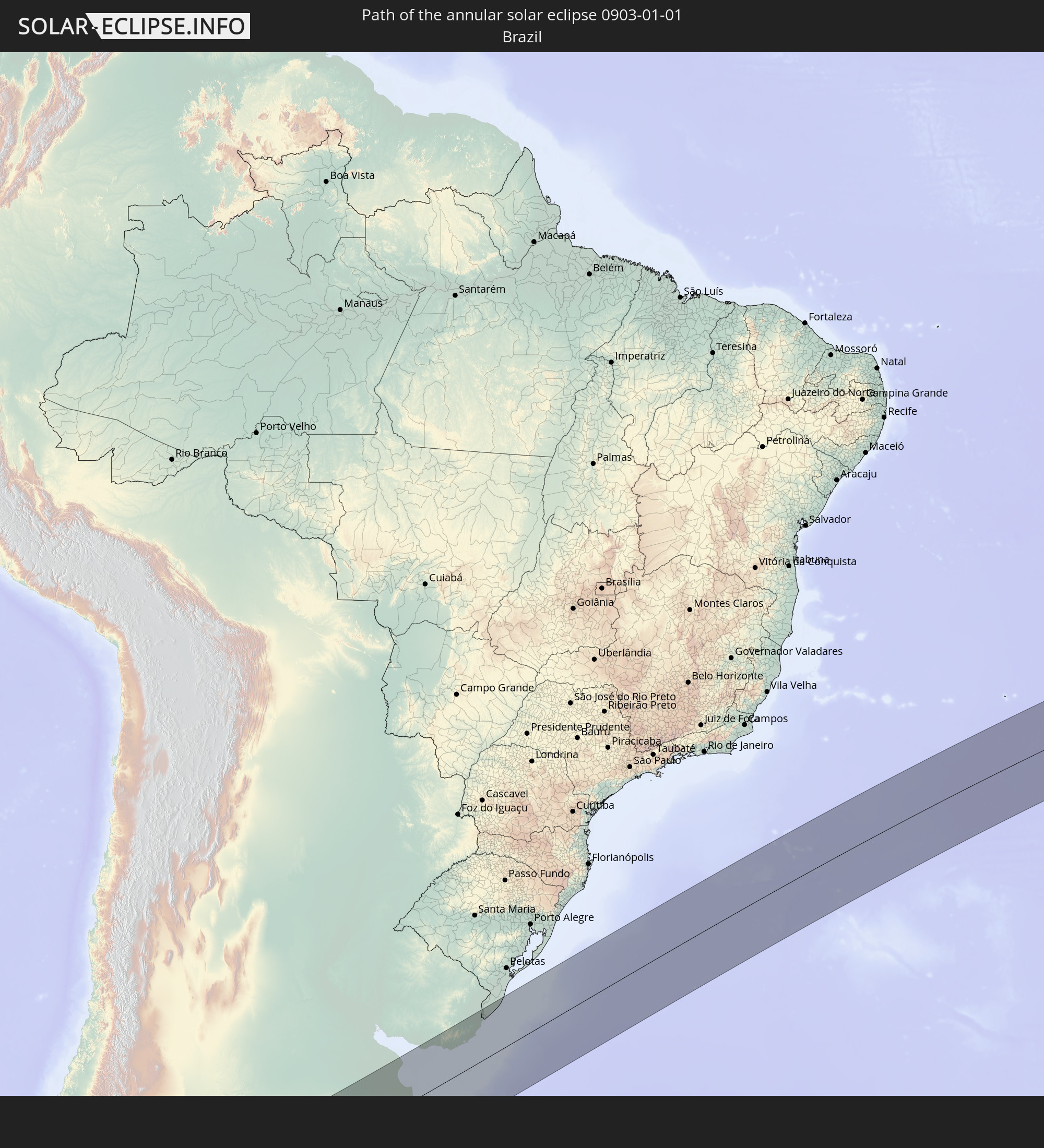 Brazil
 Argentina
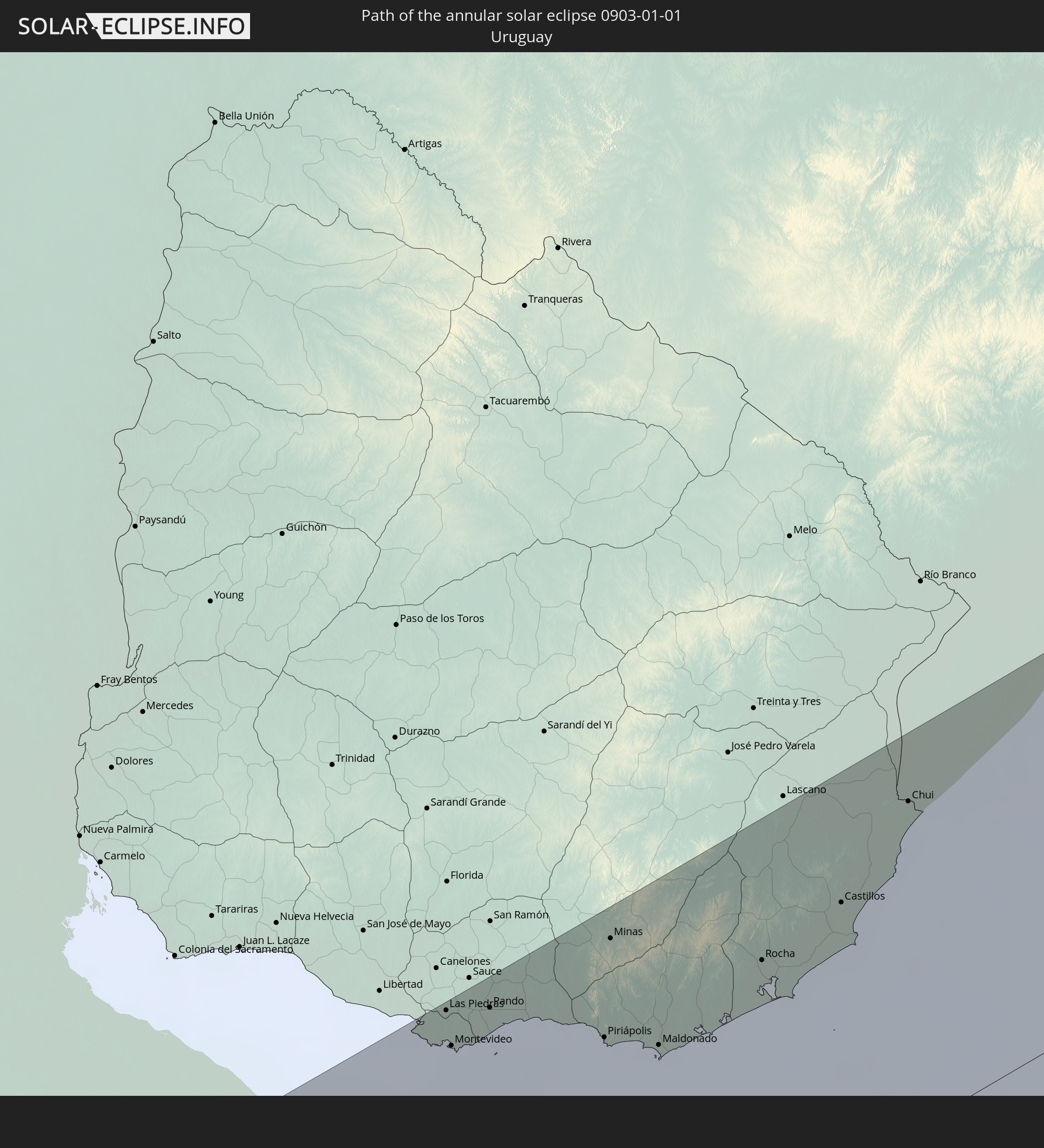 Uruguay
In den folgenden Ländern ist die Sonnenfinsternis partiell zu sehen
 Antarctica
 New Zealand
 Kiribati
 Cook Islands
 French Polynesia
 Pitcairn Islands
 Chile
Chile
 Colombia
 Peru
Peru
 Brazil
 Argentina
 Bolivia
 Paraguay
 Falkland Islands
 Guyana
 Uruguay
 Suriname
 French Guiana
 South Georgia and the South Sandwich Islands
 Saint Helena, Ascension and Tristan da Cunha
 Bouvet Island
 Australia
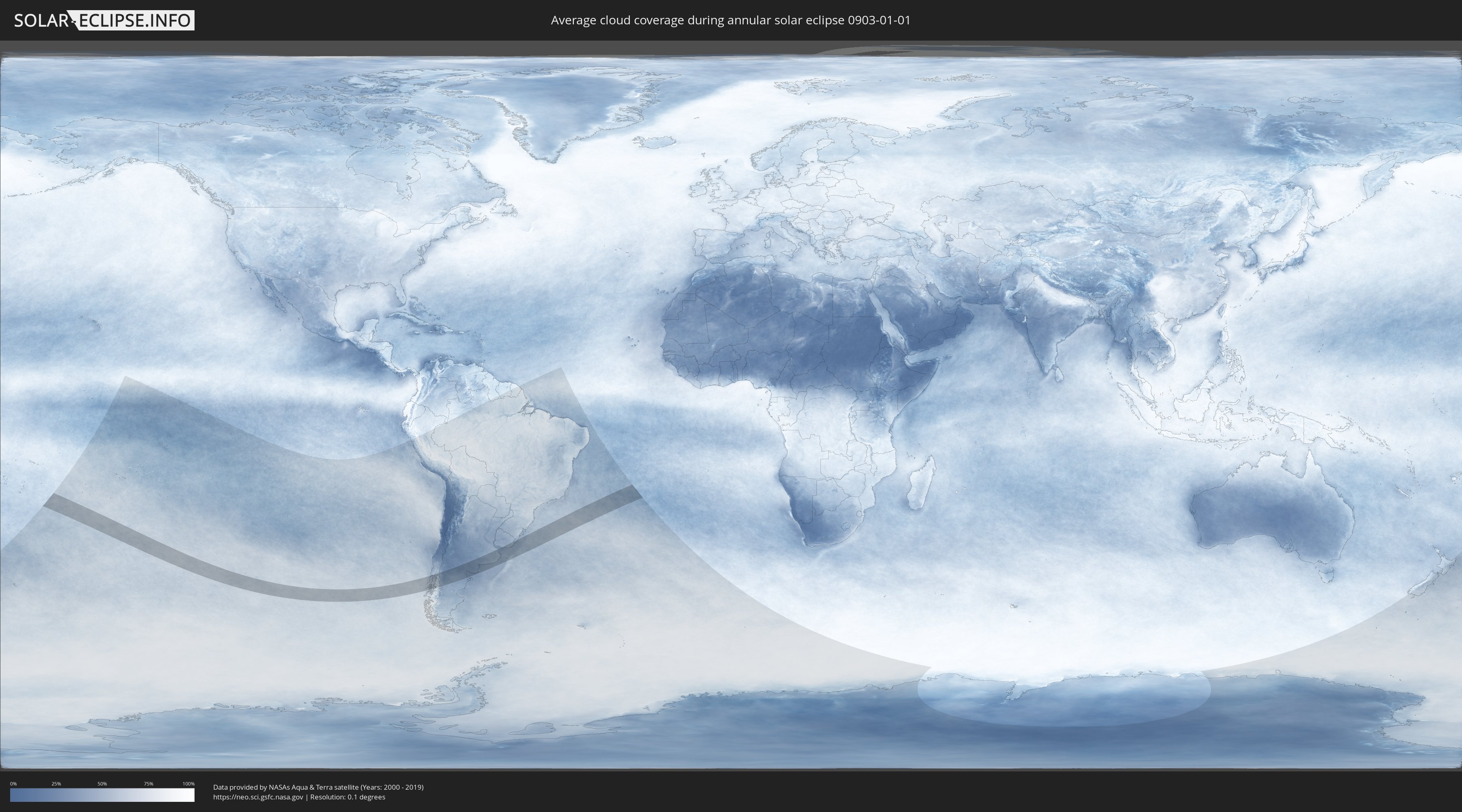
How will be the weather during the annular solar eclipse on 01/01/0903?
Where is the best place to see the annular solar eclipse of 01/01/0903?
The following maps show the average cloud coverage for the day of the annular solar eclipse.
With the help of these maps, it is possible to find the place along the eclipse path, which has the best
chance of a cloudless sky.
Nevertheless, you should consider local circumstances and inform about the weather of your chosen
observation site.
The data is provided by NASAs satellites
AQUA and TERRA.
The cloud maps are averaged over a period of 19 years (2000 - 2019).

Detailed country maps
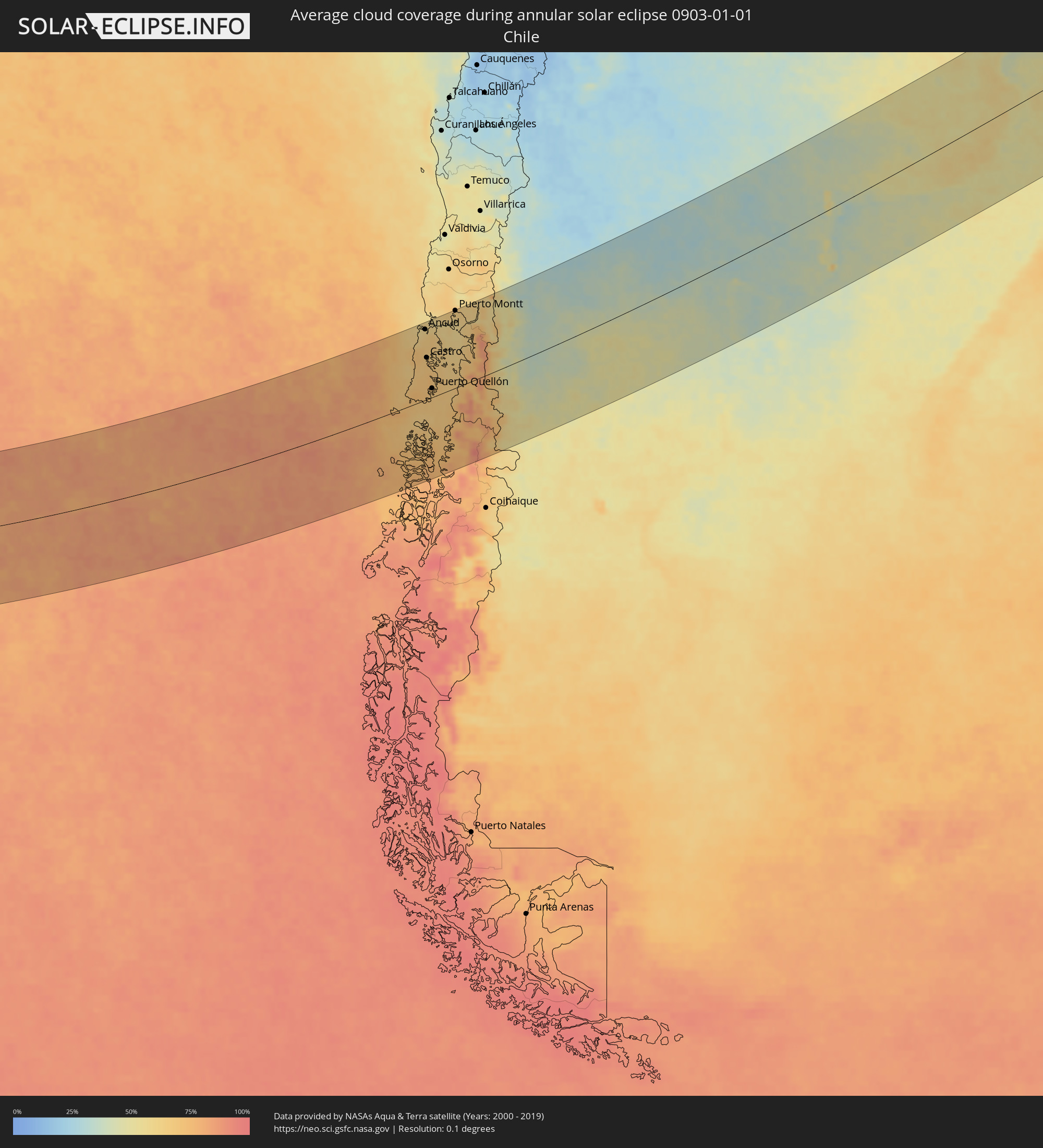 Chile
Chile
 Brazil
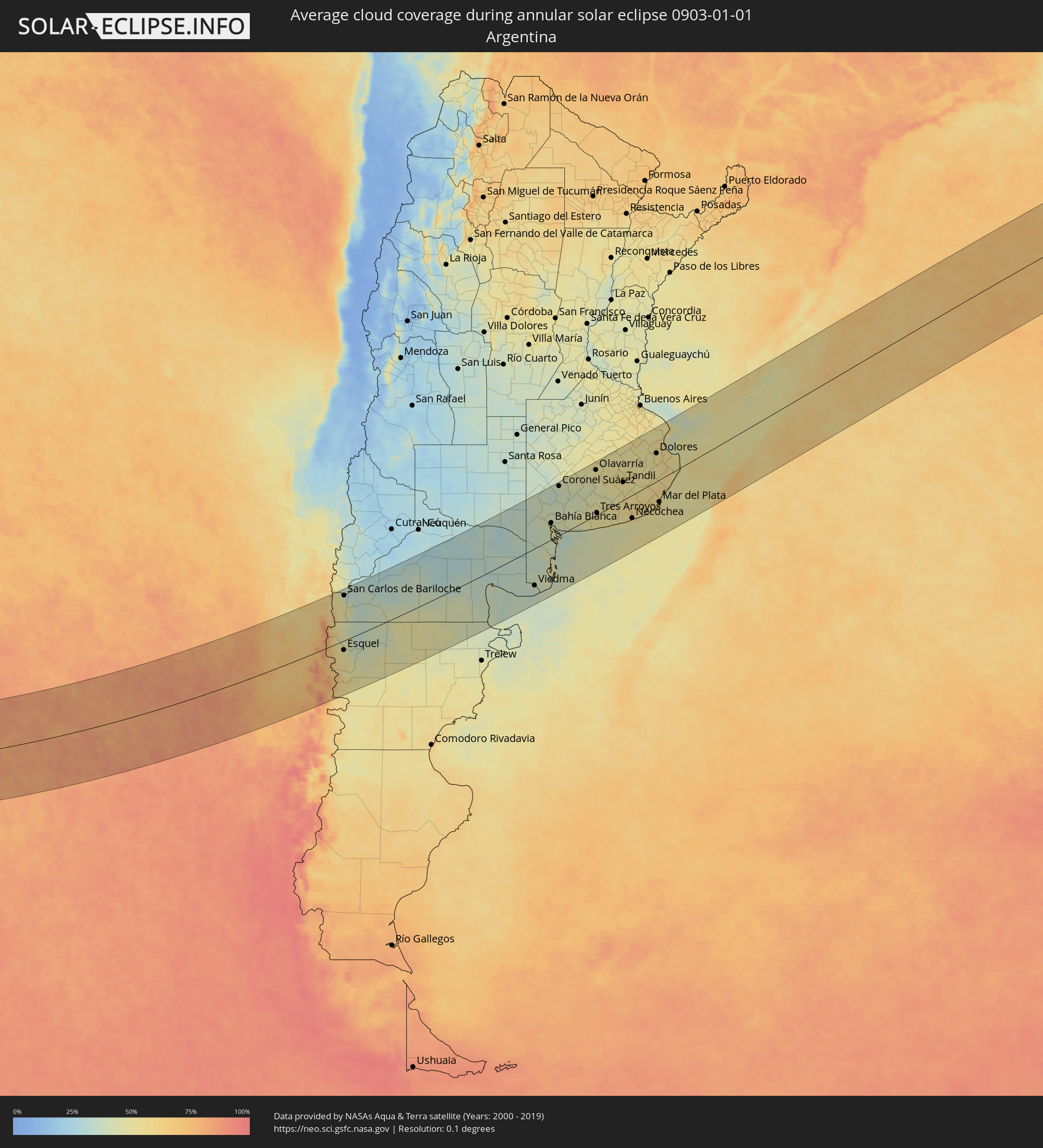 Argentina
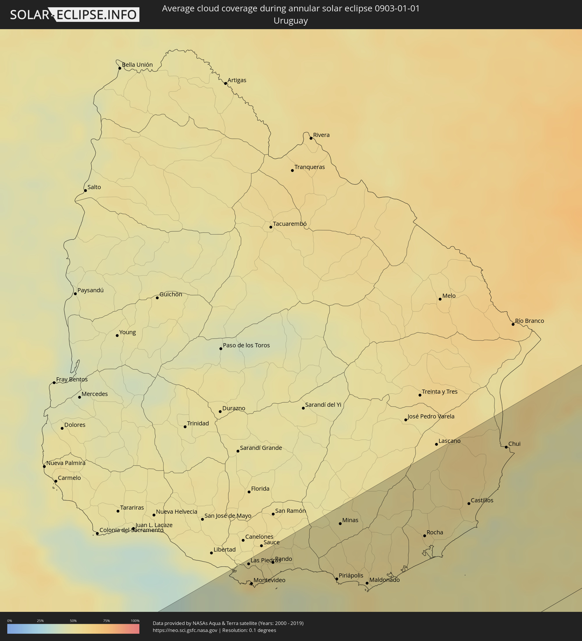 Uruguay
Cities inside the path of the eclipse
The following table shows all locations with a population of more than 5,000 inside the eclipse path. Cities which have more than 100,000 inhabitants are marked bold. A click at the locations opens a detailed map.
| City | Type | Eclipse duration | Local time of max. eclipse | Distance to central line | Ø Cloud coverage |
|
Ancud, Los Lagos
|
annular | - | 14:34:09 UTC-04:42 | 155 km | 62% |
|
Chonchi, Los Lagos
|
annular | - | 14:33:05 UTC-04:42 | 76 km | 69% |
|
Castro, Los Lagos
|
annular | - | 14:33:19 UTC-04:42 | 91 km | 67% |
|
Puerto Quellón, Los Lagos
|
annular | - | 14:32:38 UTC-04:42 | 20 km | 69% |
|
Calbuco, Los Lagos
|
annular | - | 14:35:32 UTC-04:42 | 144 km | 62% |
|
Puerto Montt, Los Lagos
|
annular | - | 14:36:19 UTC-04:42 | 170 km | 64% |
|
El Bolsón, Río Negro Province
|
annular | - | 15:03:58 UTC-04:16 | 73 km | 49% |
|
Trevelin, Chubut Province
|
annular | - | 15:02:18 UTC-04:16 | 44 km | 52% |
|
Esquel, Chubut Province
|
annular | - | 15:02:49 UTC-04:16 | 31 km | 49% |
|
San Carlos de Bariloche, Río Negro Province
|
annular | - | 15:05:38 UTC-04:16 | 149 km | 39% |
|
Ingeniero Jacobacci, Río Negro Province
|
annular | - | 15:08:13 UTC-04:16 | 71 km | 37% |
|
Fray Luis Beltrán, Río Negro Province
|
annular | - | 15:17:17 UTC-04:16 | 135 km | 33% |
|
Lamarque, Río Negro Province
|
annular | - | 15:17:12 UTC-04:16 | 122 km | 34% |
|
Choele Choel, Río Negro Province
|
annular | - | 15:17:30 UTC-04:16 | 137 km | 34% |
|
Sierra Grande, Río Negro Province
|
annular | - | 15:13:56 UTC-04:16 | 108 km | 39% |
|
San Antonio Oeste, Río Negro Province
|
annular | - | 15:15:59 UTC-04:16 | 37 km | 44% |
|
General Conesa, Río Negro Province
|
annular | - | 15:17:46 UTC-04:16 | 6 km | 33% |
|
Viedma, Río Negro Province
|
annular | - | 15:18:22 UTC-04:16 | 121 km | 40% |
|
Bahía Blanca, Buenos Aires
|
annular | - | 15:22:55 UTC-04:16 | 55 km | 44% |
|
Punta Alta, Buenos Aires
|
annular | - | 15:22:53 UTC-04:16 | 32 km | 43% |
|
Coronel Suárez, Buenos Aires
|
annular | - | 15:25:32 UTC-04:16 | 166 km | 40% |
|
Coronel Dorrego, Buenos Aires
|
annular | - | 15:24:06 UTC-04:16 | 15 km | 45% |
|
Olavarría, Buenos Aires
|
annular | - | 15:28:24 UTC-04:16 | 153 km | 51% |
|
Tres Arroyos, Buenos Aires
|
annular | - | 15:25:51 UTC-04:16 | 6 km | 50% |
|
Azul, Buenos Aires
|
annular | - | 15:29:07 UTC-04:16 | 144 km | 52% |
|
Tandil, Buenos Aires
|
annular | - | 15:28:56 UTC-04:16 | 60 km | 53% |
|
Necochea, Buenos Aires
|
annular | - | 15:27:12 UTC-04:16 | 77 km | 51% |
|
Dolores, Buenos Aires
|
annular | - | 15:32:11 UTC-04:16 | 95 km | 55% |
|
Mar del Plata, Buenos Aires
|
annular | - | 15:29:21 UTC-04:16 | 74 km | 58% |
|
Villa Gesell, Buenos Aires
|
annular | - | 15:31:13 UTC-04:16 | 29 km | 49% |
|
San Clemente del Tuyú, Buenos Aires
|
annular | - | 15:33:01 UTC-04:16 | 48 km | 50% |
|
Delta del Tigre, San José
|
annular | - | 16:08:02 UTC-03:44 | 186 km | 44% |
|
La Paz, Canelones
|
annular | - | 16:08:10 UTC-03:44 | 180 km | 57% |
|
Las Piedras, Canelones
|
annular | - | 16:08:13 UTC-03:44 | 183 km | 54% |
|
Montevideo, Montevideo
|
annular | - | 16:07:57 UTC-03:44 | 165 km | 46% |
|
Paso de Carrasco, Canelones
|
annular | - | 16:08:09 UTC-03:44 | 163 km | 48% |
|
Joaquín Suárez, Canelones
|
annular | - | 16:08:23 UTC-03:44 | 174 km | 53% |
|
Colonia Nicolich, Canelones
|
annular | - | 16:08:15 UTC-03:44 | 166 km | 50% |
|
Pando, Canelones
|
annular | - | 16:08:29 UTC-03:44 | 172 km | 53% |
|
Piriápolis, Maldonado
|
annular | - | 16:08:50 UTC-03:44 | 127 km | 46% |
|
Minas, Lavalleja
|
annular | - | 16:09:41 UTC-03:44 | 173 km | 52% |
|
Pan de Azúcar, Maldonado
|
annular | - | 16:09:00 UTC-03:44 | 134 km | 52% |
|
Maldonado, Maldonado
|
annular | - | 16:09:02 UTC-03:44 | 109 km | 55% |
|
Punta del Este, Maldonado
|
annular | - | 16:08:58 UTC-03:44 | 104 km | 55% |
|
San Carlos, Maldonado
|
annular | - | 16:09:15 UTC-03:44 | 118 km | 52% |
|
Rocha, Rocha
|
annular | - | 16:10:15 UTC-03:44 | 121 km | 51% |
|
Castillos, Rocha
|
annular | - | 16:11:06 UTC-03:44 | 127 km | 49% |
|
Chui, Rocha
|
annular | - | 16:12:15 UTC-03:44 | 157 km | 55% |
|
Chuí, Rio Grande do Sul
|
annular | - | 16:12:16 UTC-03:44 | 157 km | 55% |
|
Santa Vitória do Palmar, Rio Grande do Sul
|
annular | - | 16:51:00 UTC-03:06 | 170 km | 57% |