Total solar eclipse of 08/24/1188
| Day of week: | Wednesday |
| Maximum duration of eclipse: | 05m01s |
| Maximum width of eclipse path: | 197 km |
| Saros cycle: | 112 |
| Coverage: | 100% |
| Magnitude: | 1.0598 |
| Gamma: | -0.0082 |
Wo kann man die Sonnenfinsternis vom 08/24/1188 sehen?
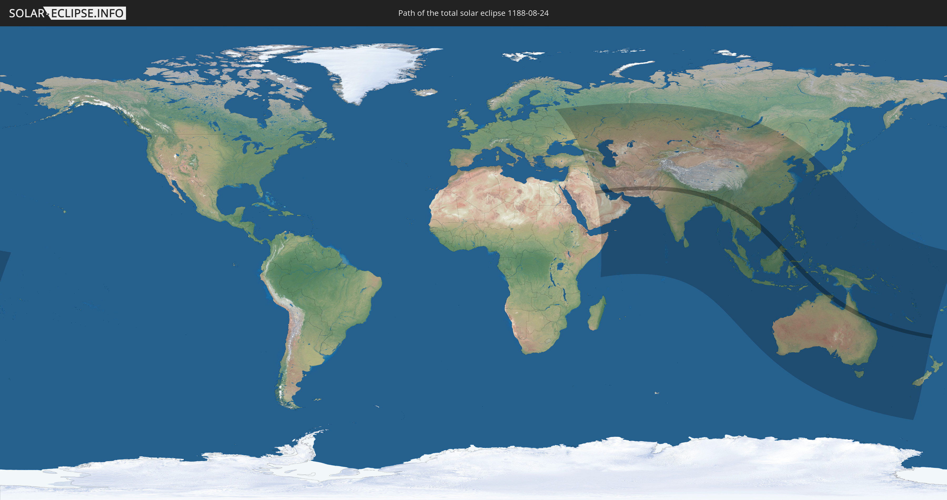
Die Sonnenfinsternis am 08/24/1188 kann man in 67 Ländern als partielle Sonnenfinsternis beobachten.
Der Finsternispfad verläuft durch 14 Länder. Nur in diesen Ländern ist sie als total Sonnenfinsternis zu sehen.
In den folgenden Ländern ist die Sonnenfinsternis total zu sehen
 Saudi Arabia
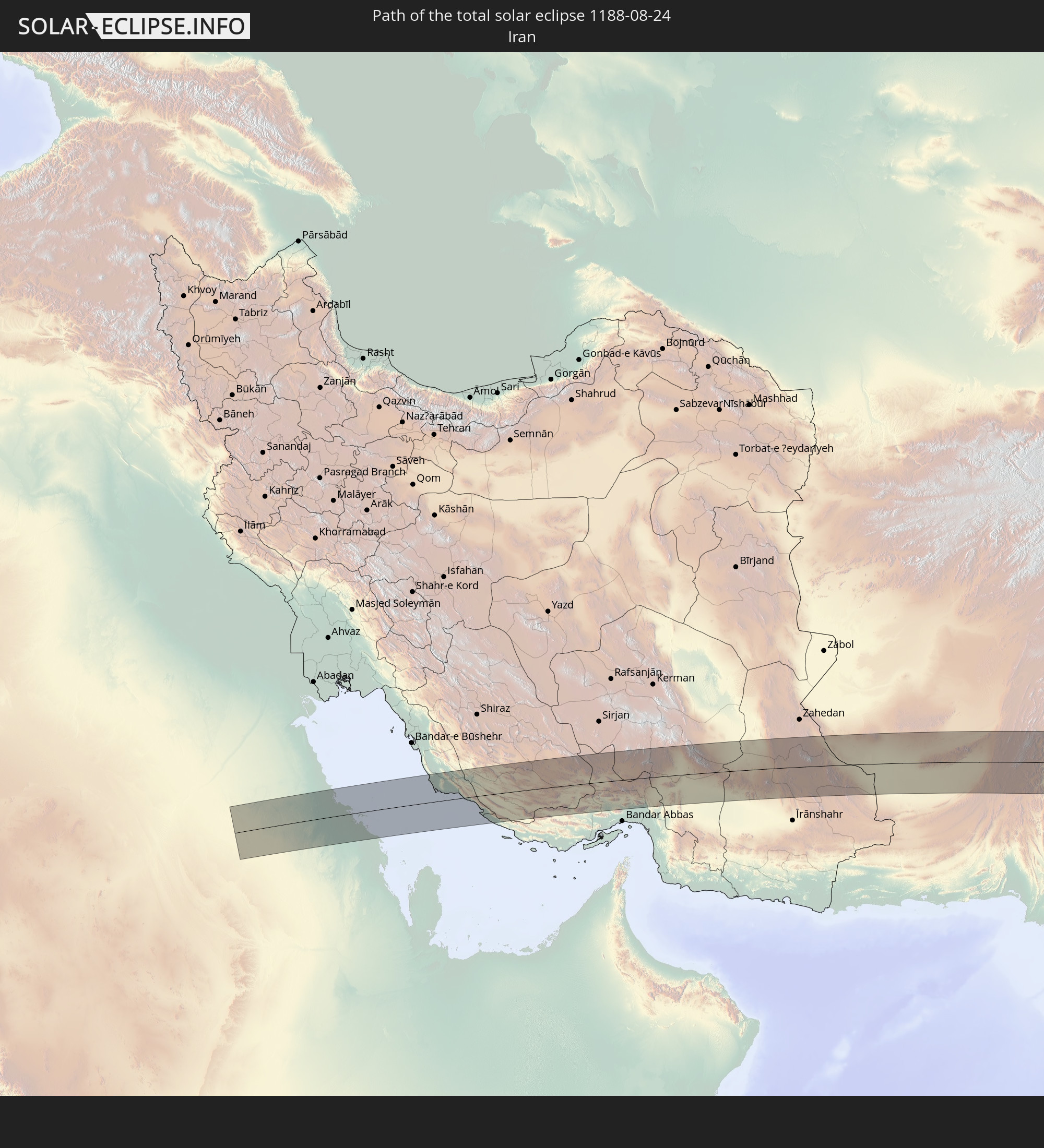 Iran
Iran
 Pakistan
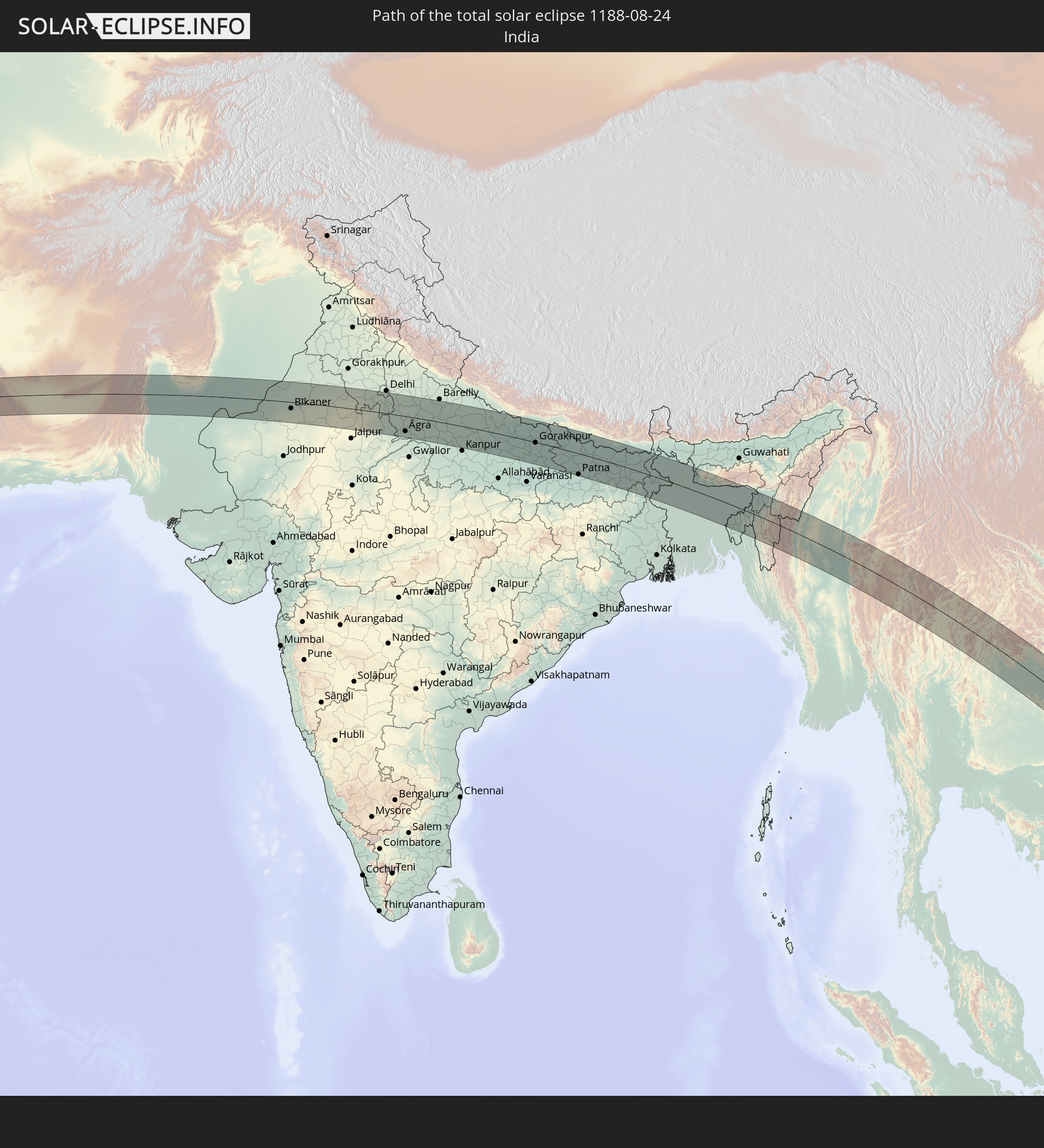 India
India
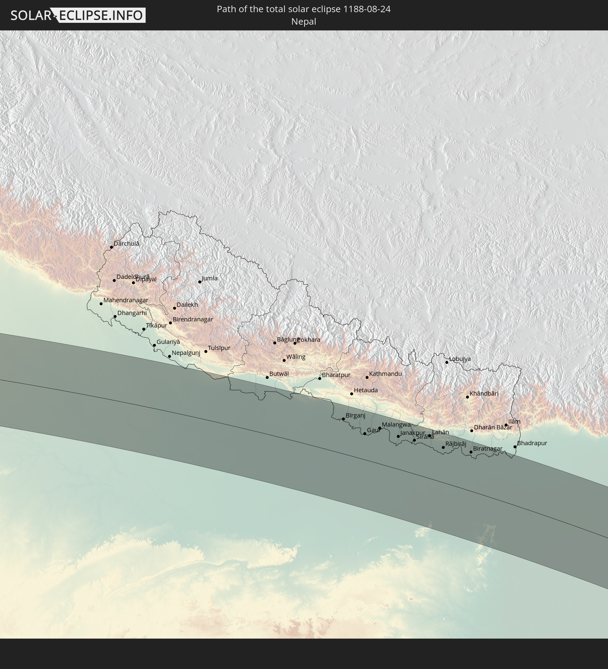 Nepal
Nepal
 Bangladesh
 Myanmar
 Indonesia
 Thailand
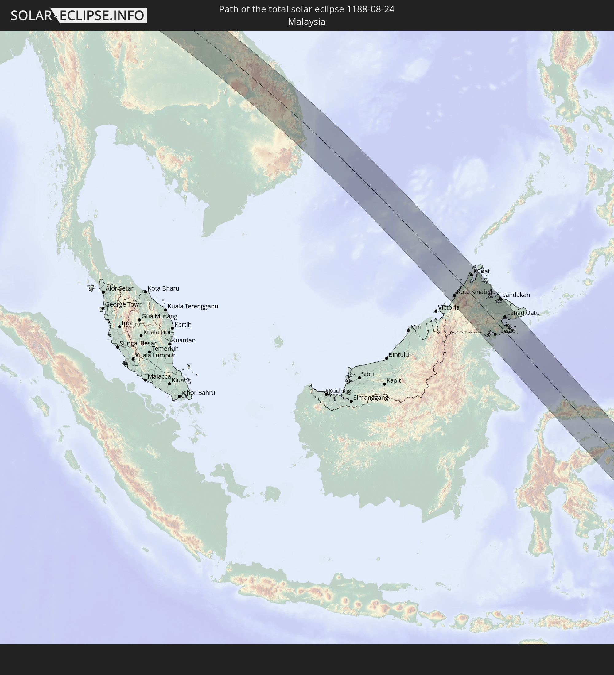 Malaysia
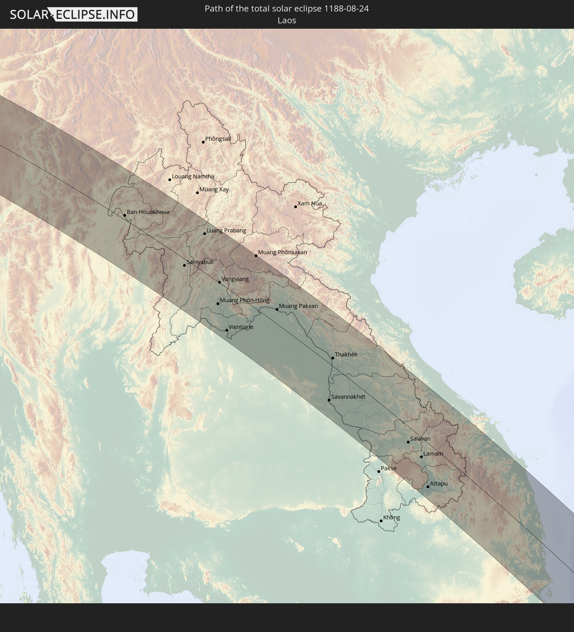 Laos
Laos
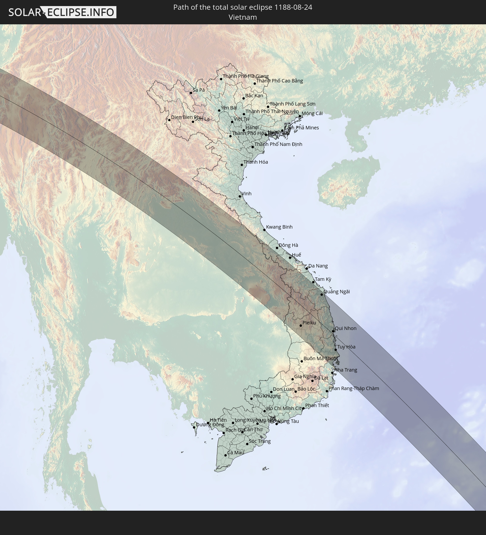 Vietnam
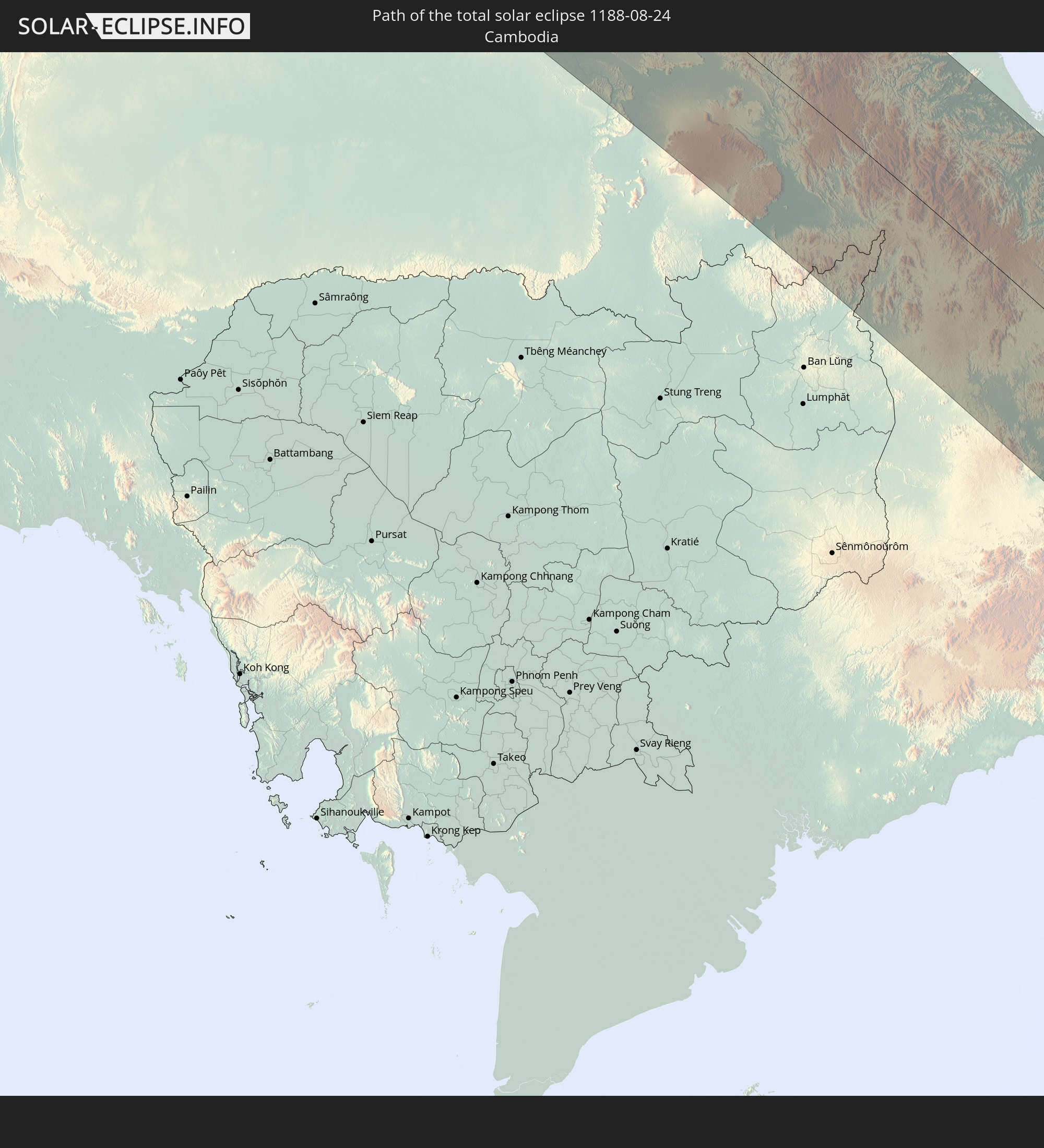 Cambodia
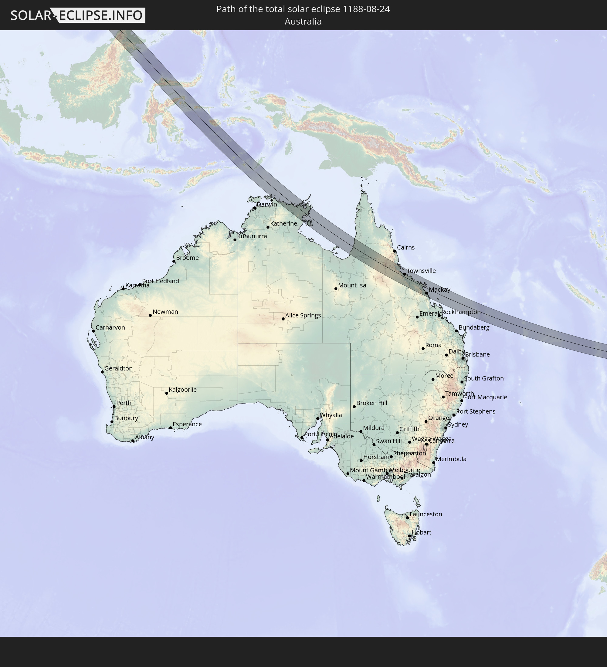 Australia
In den folgenden Ländern ist die Sonnenfinsternis partiell zu sehen
 Russia
 Fiji
Fiji
 New Zealand
 Kiribati
 Ukraine
 Turkey
 Saudi Arabia
 Iraq
Iraq
 Georgia
 Somalia
 Yemen
Yemen
 Armenia
 Iran
Iran
 Azerbaijan
 Seychelles
 Kazakhstan
 Kuwait
 Bahrain
 Qatar
Qatar
 United Arab Emirates
 Oman
Oman
 Turkmenistan
 Uzbekistan
 Afghanistan
 Pakistan
 Tajikistan
 India
India
 Kyrgyzstan
 Maldives
 China
China
 Sri Lanka
 Nepal
Nepal
 Mongolia
 Bangladesh
 Bhutan
 Myanmar
 Indonesia
 Cocos Islands
 Thailand
 Malaysia
 Laos
Laos
 Vietnam
 Cambodia
 Singapore
 Christmas Island
 Australia
 Macau
Macau
 Hong Kong
 Brunei
 Taiwan
 Philippines
 Japan
Japan
 East Timor
 North Korea
 South Korea
 Palau
Palau
 Federated States of Micronesia
 Papua New Guinea
 Guam
Guam
 Northern Mariana Islands
 Solomon Islands
 New Caledonia
 Marshall Islands
 Vanuatu
 Nauru
Nauru
 Norfolk Island
 Tuvalu
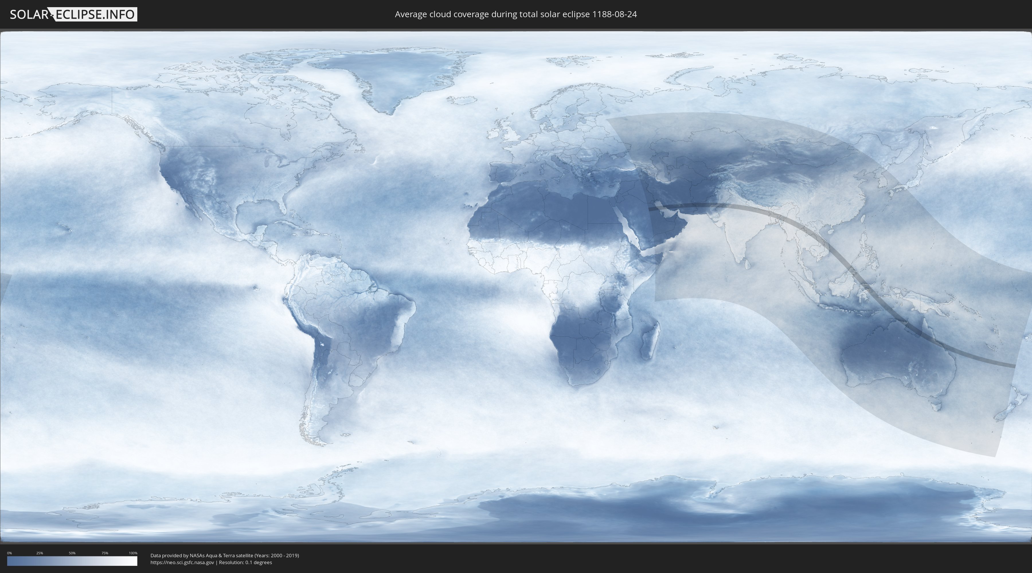
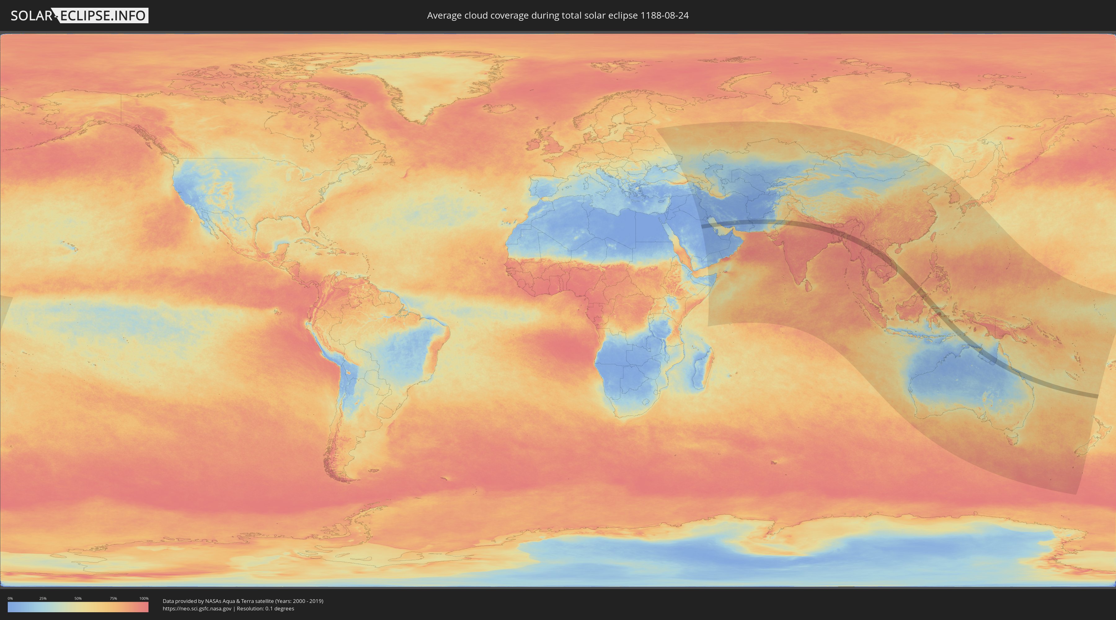
How will be the weather during the total solar eclipse on 08/24/1188?
Where is the best place to see the total solar eclipse of 08/24/1188?
The following maps show the average cloud coverage for the day of the total solar eclipse.
With the help of these maps, it is possible to find the place along the eclipse path, which has the best
chance of a cloudless sky.
Nevertheless, you should consider local circumstances and inform about the weather of your chosen
observation site.
The data is provided by NASAs satellites
AQUA and TERRA.
The cloud maps are averaged over a period of 19 years (2000 - 2019).
Detailed country maps
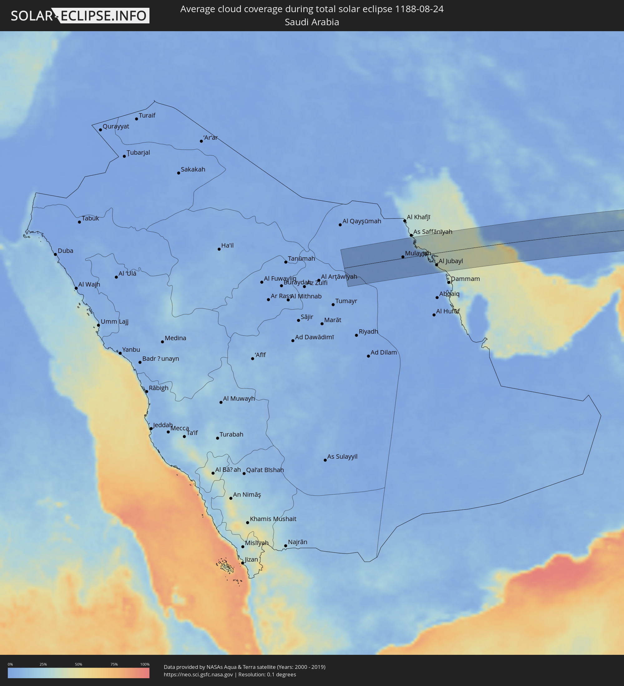 Saudi Arabia
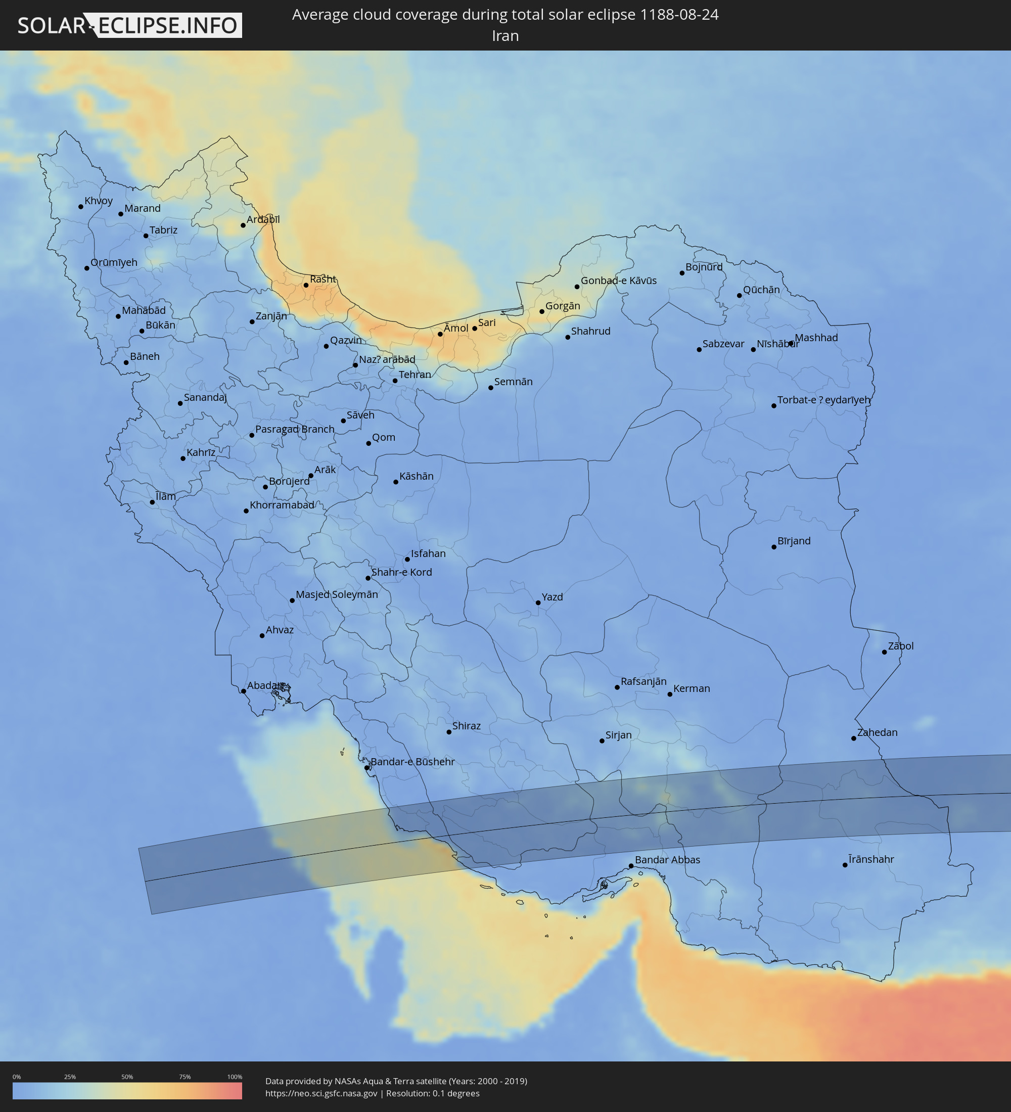 Iran
Iran
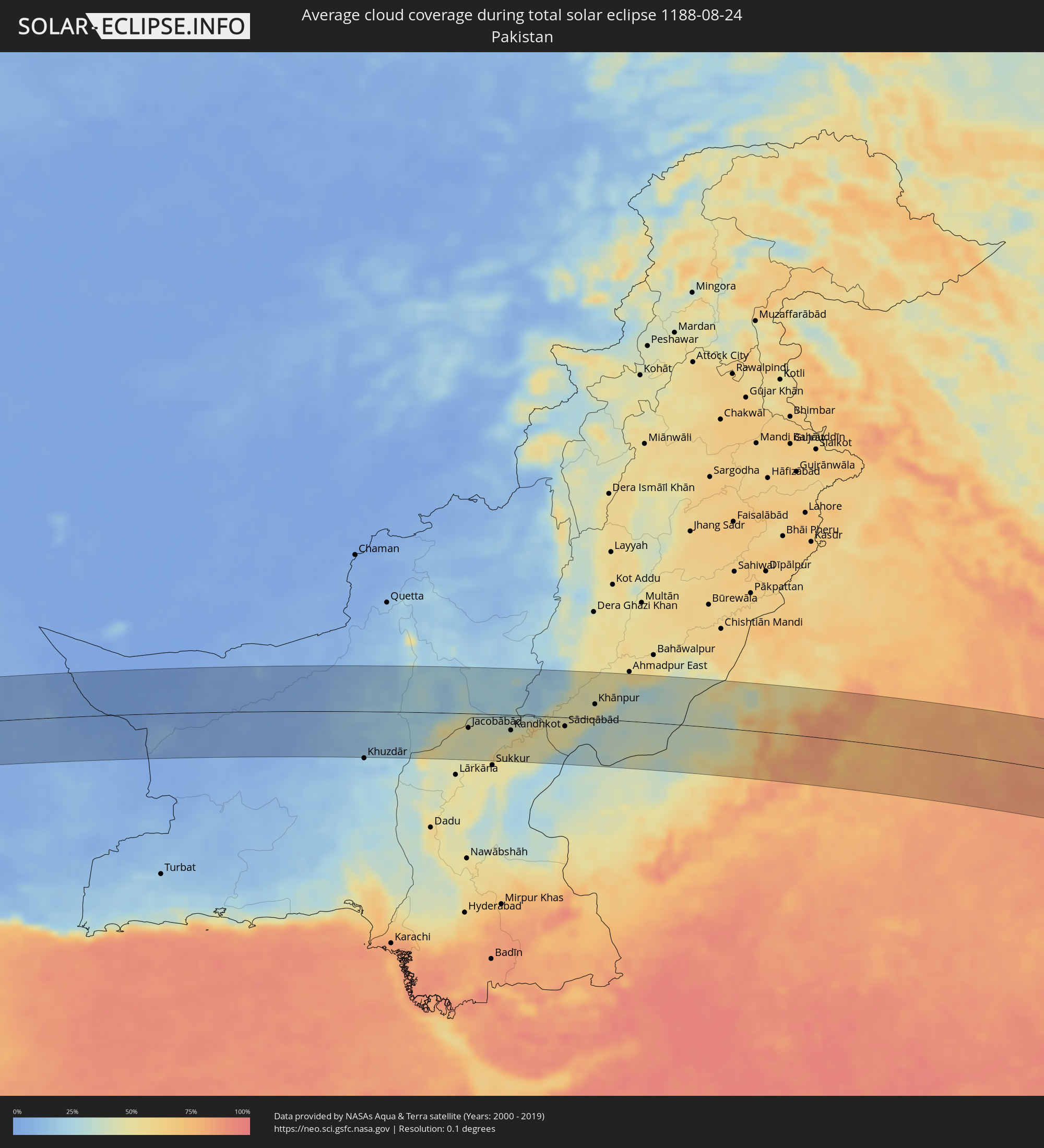 Pakistan
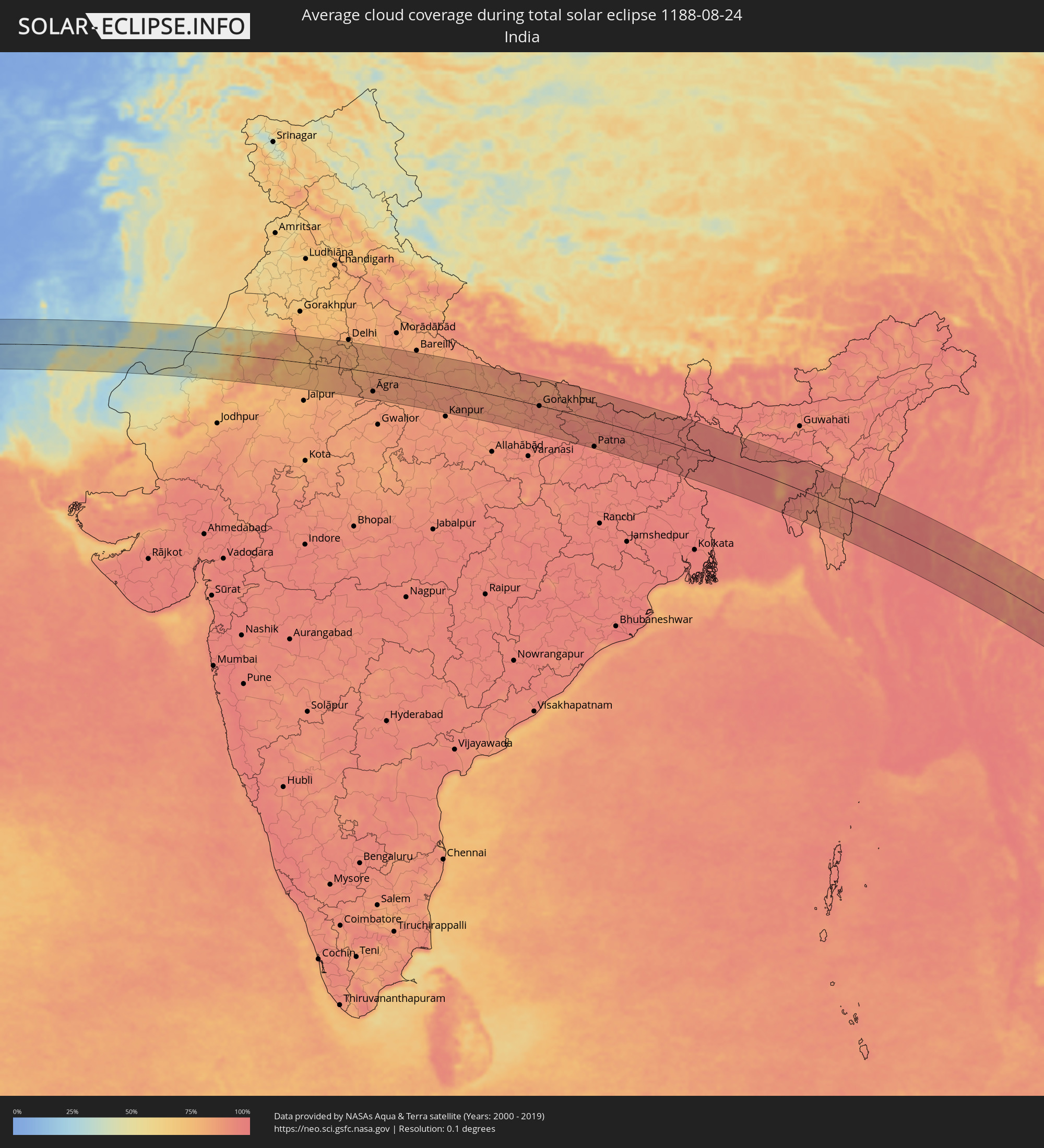 India
India
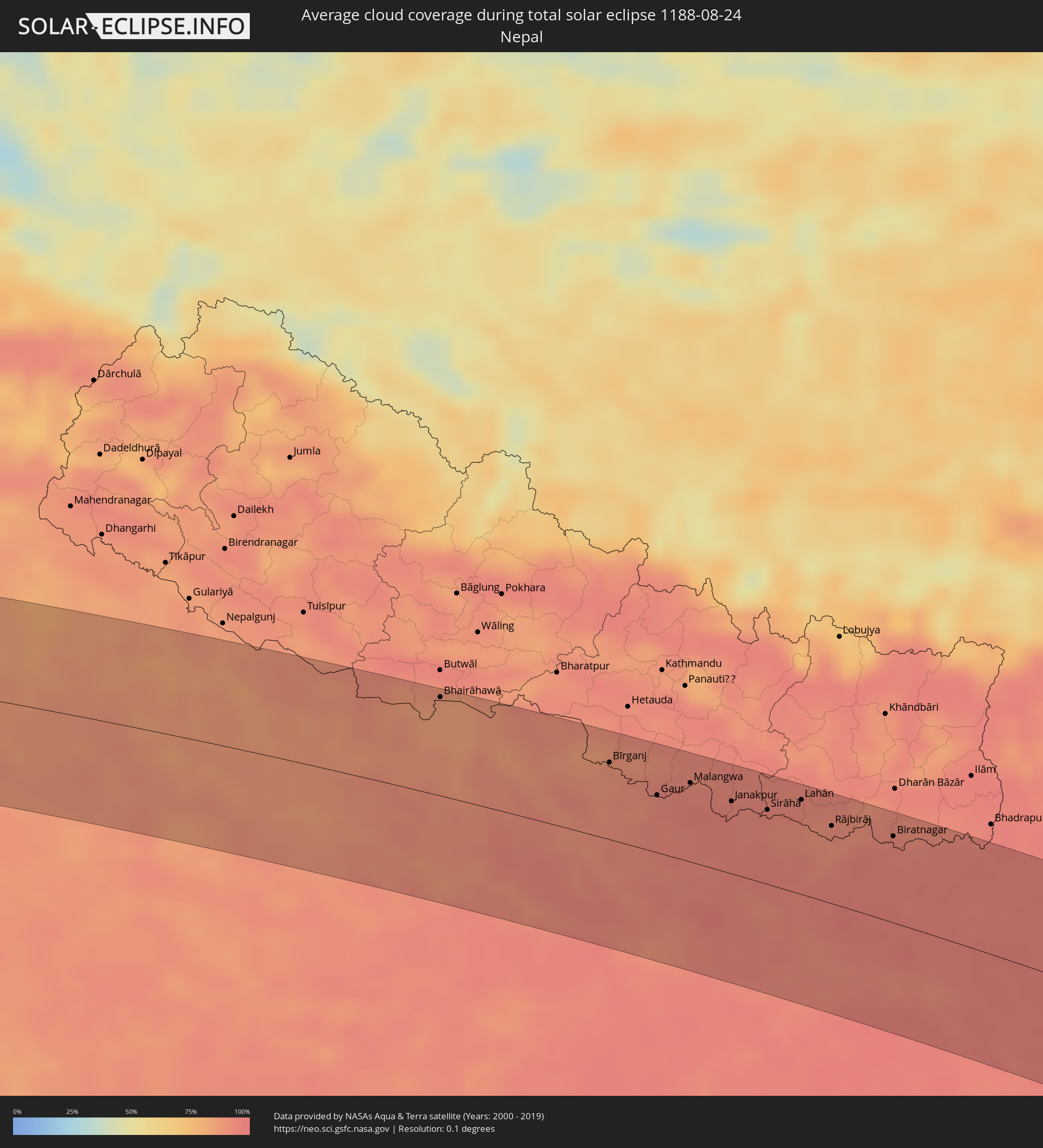 Nepal
Nepal
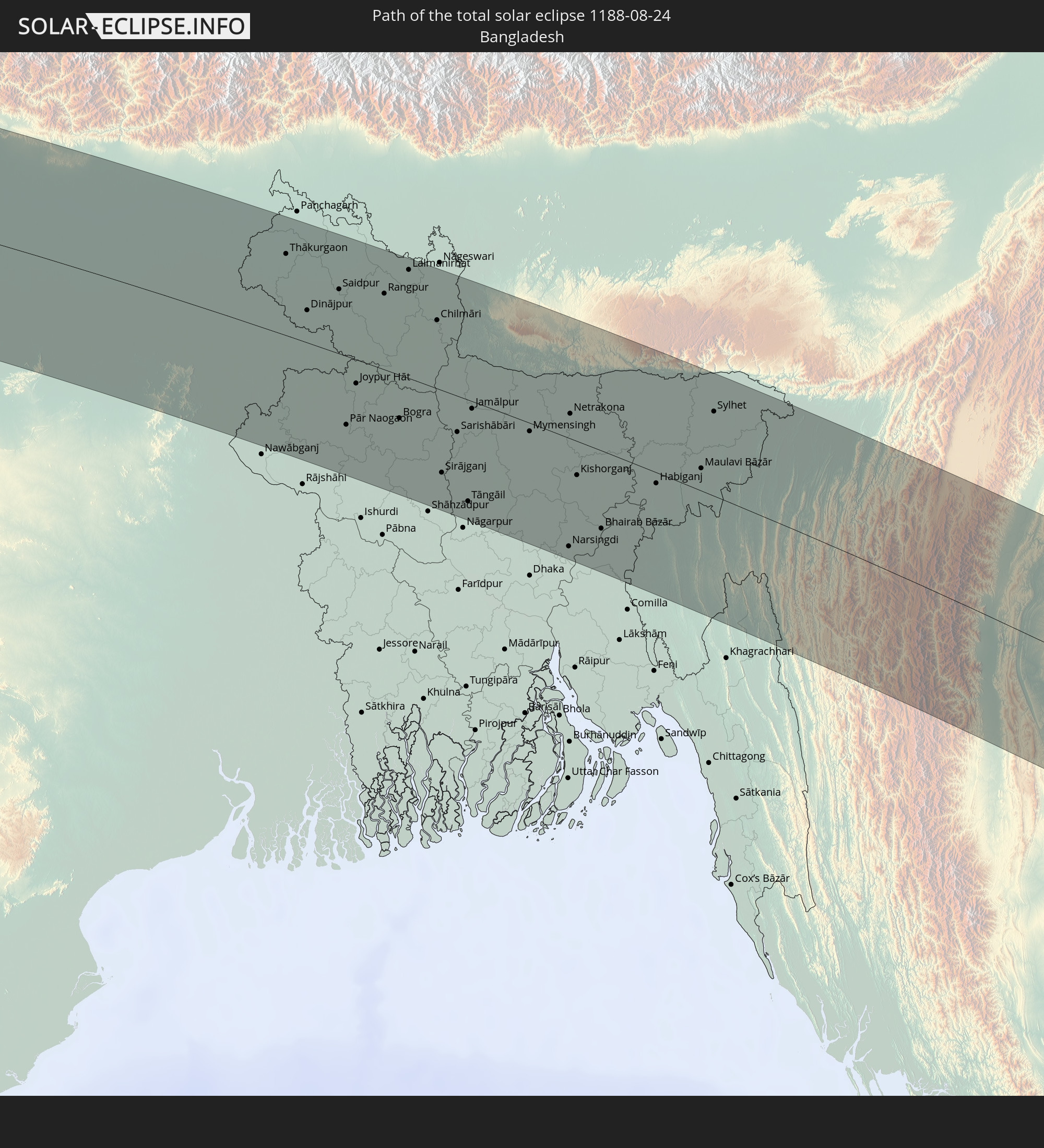
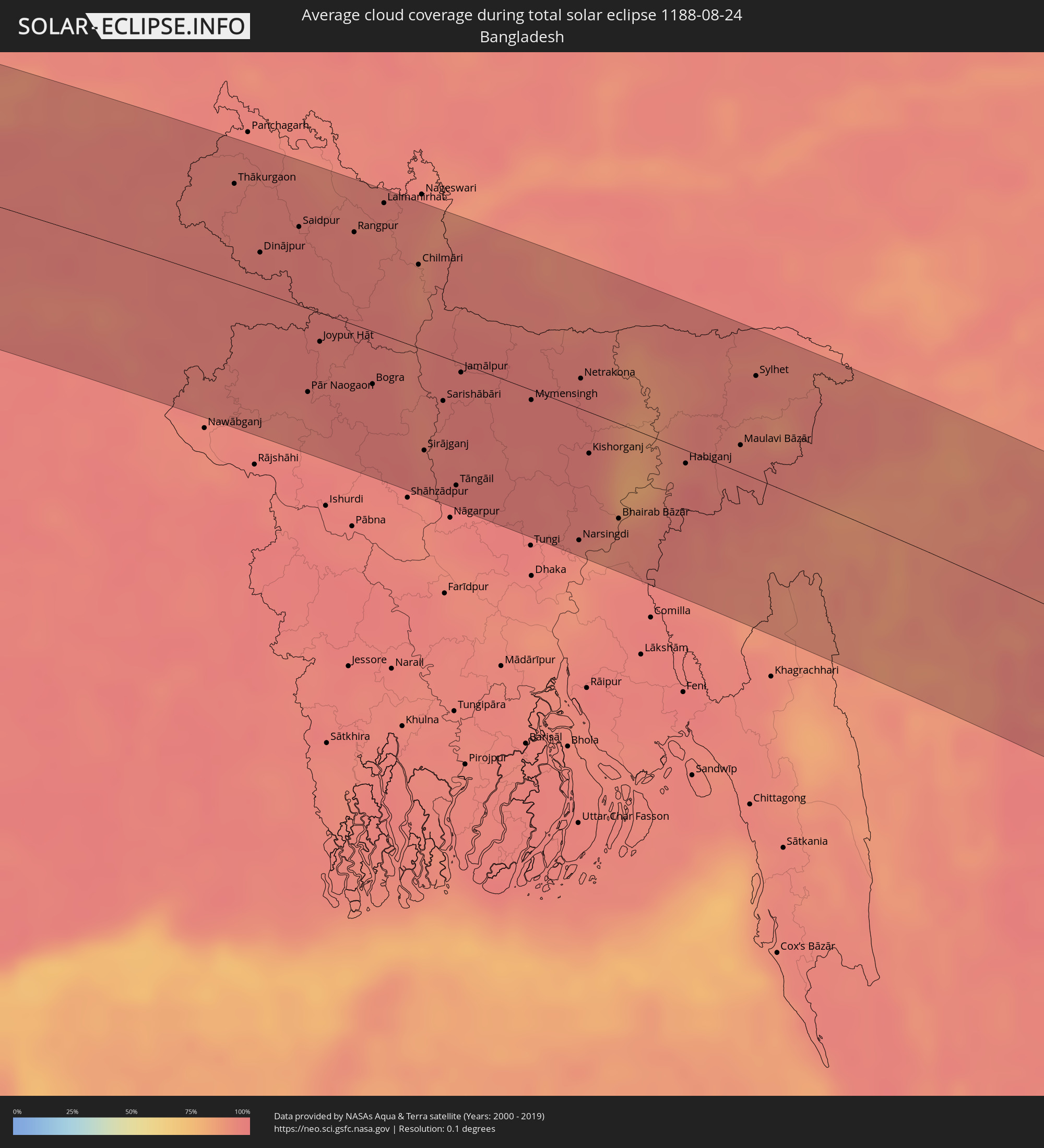 Bangladesh
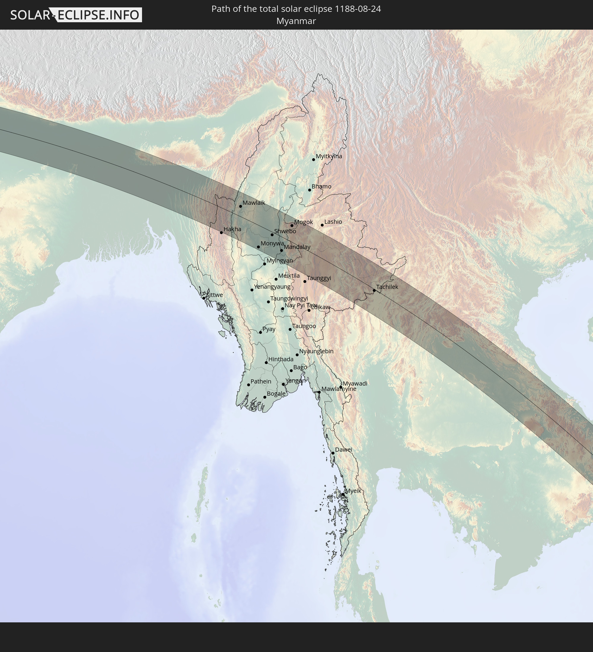
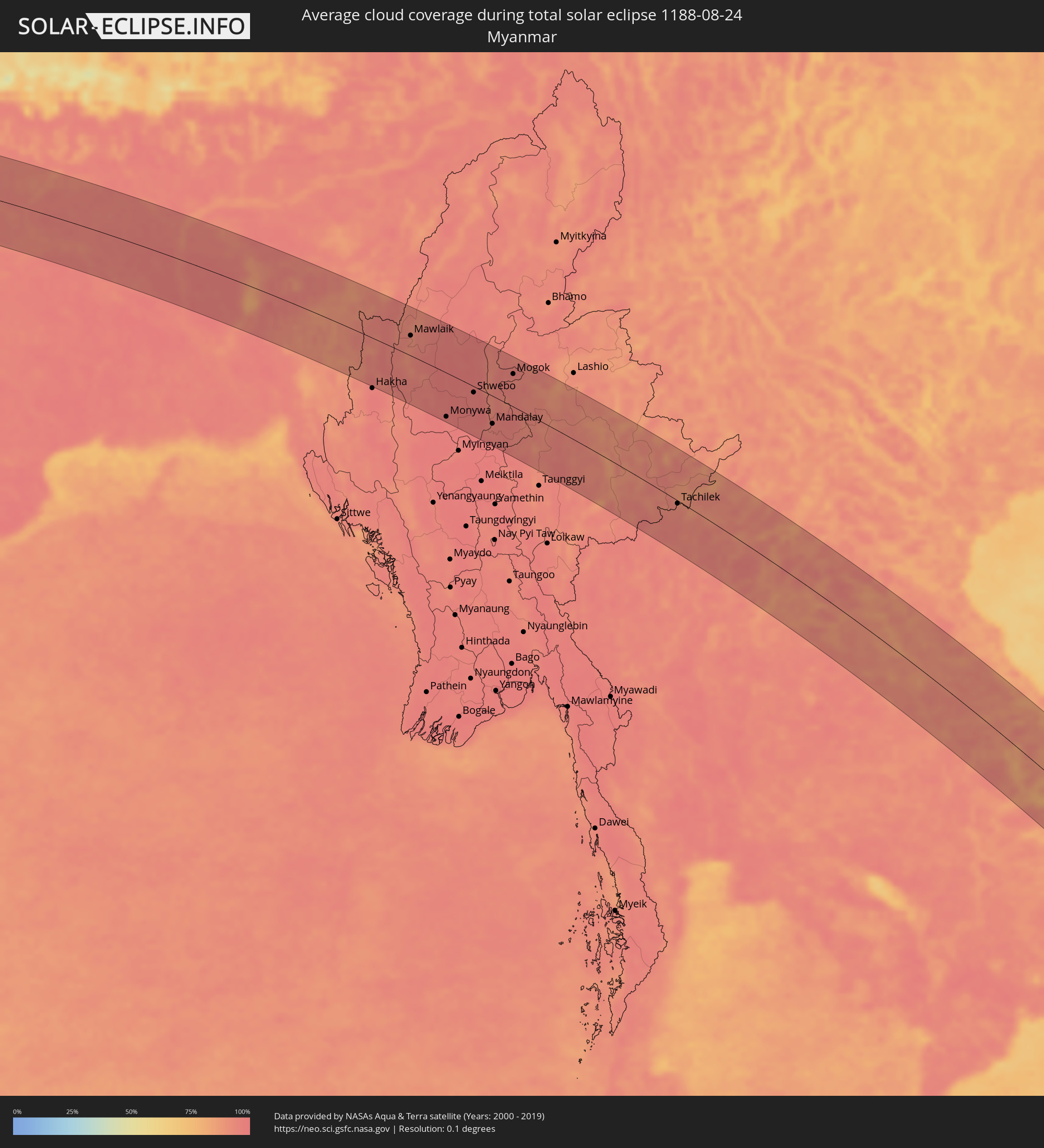 Myanmar
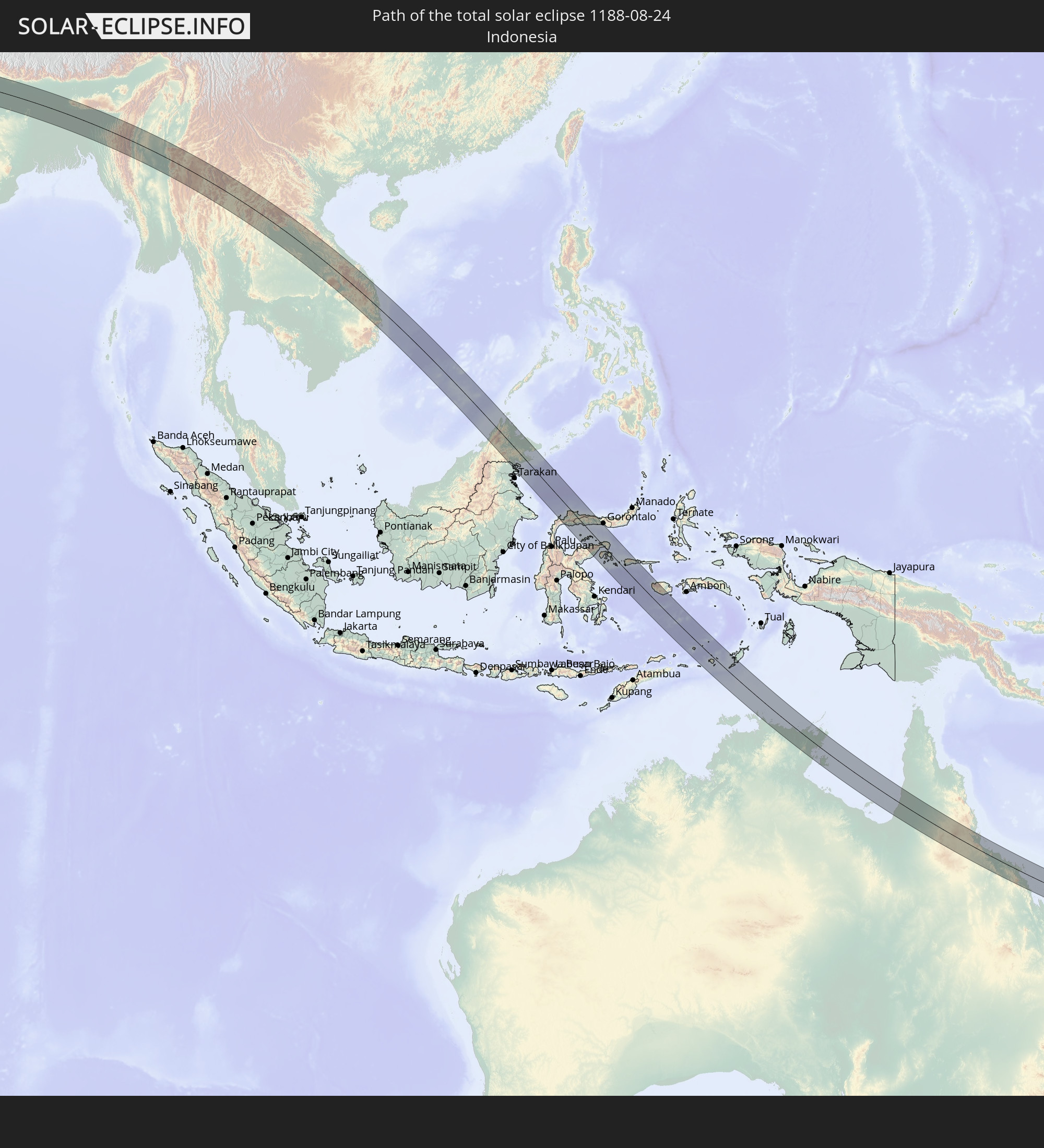
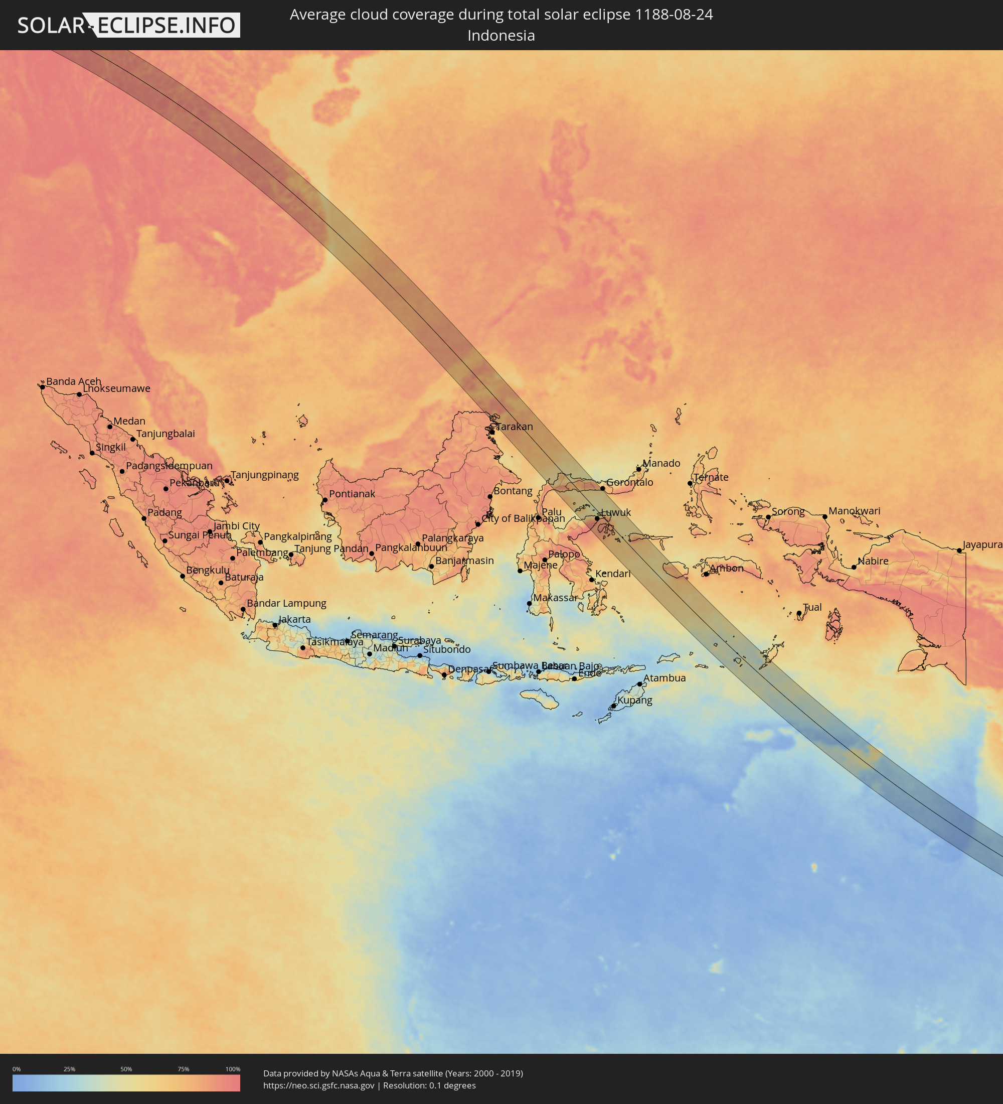 Indonesia
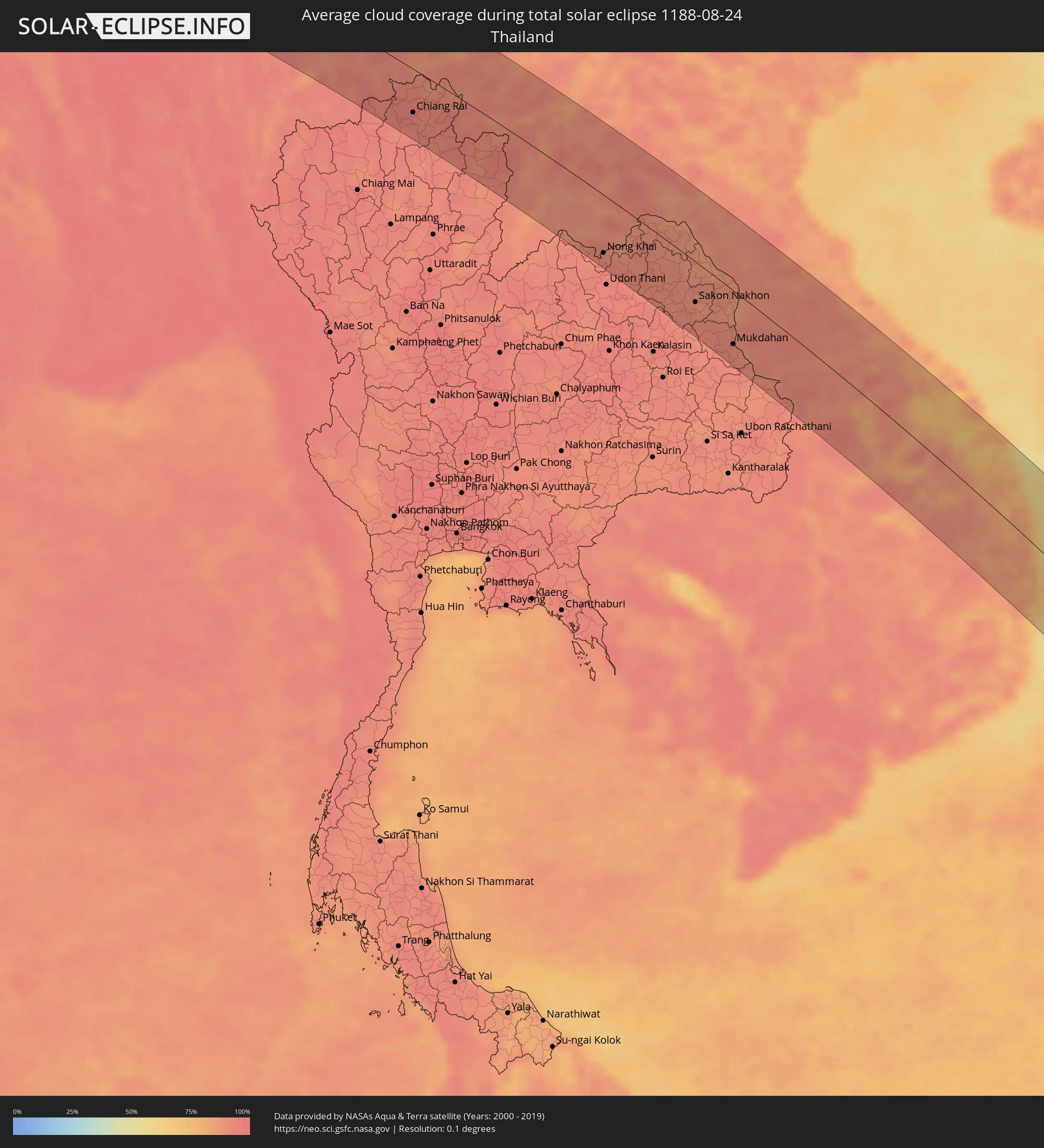 Thailand
 Malaysia
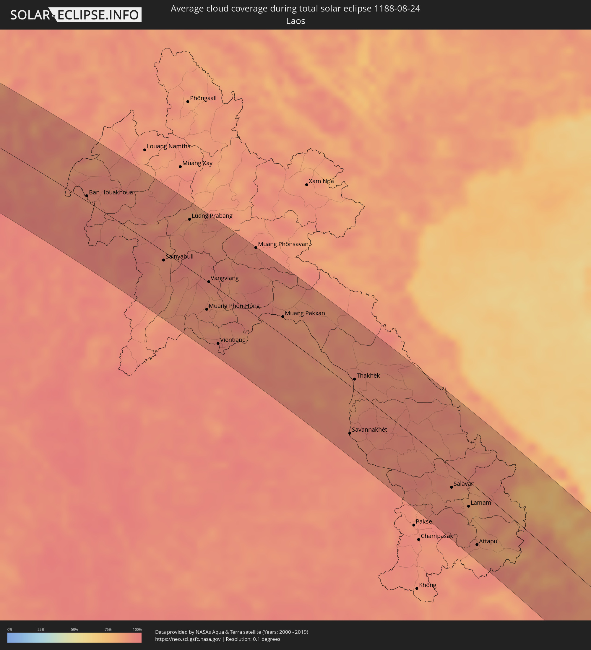 Laos
Laos
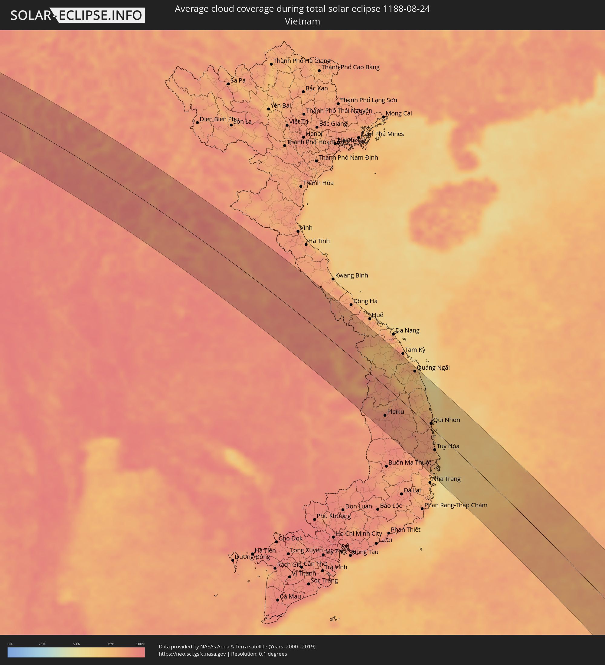 Vietnam
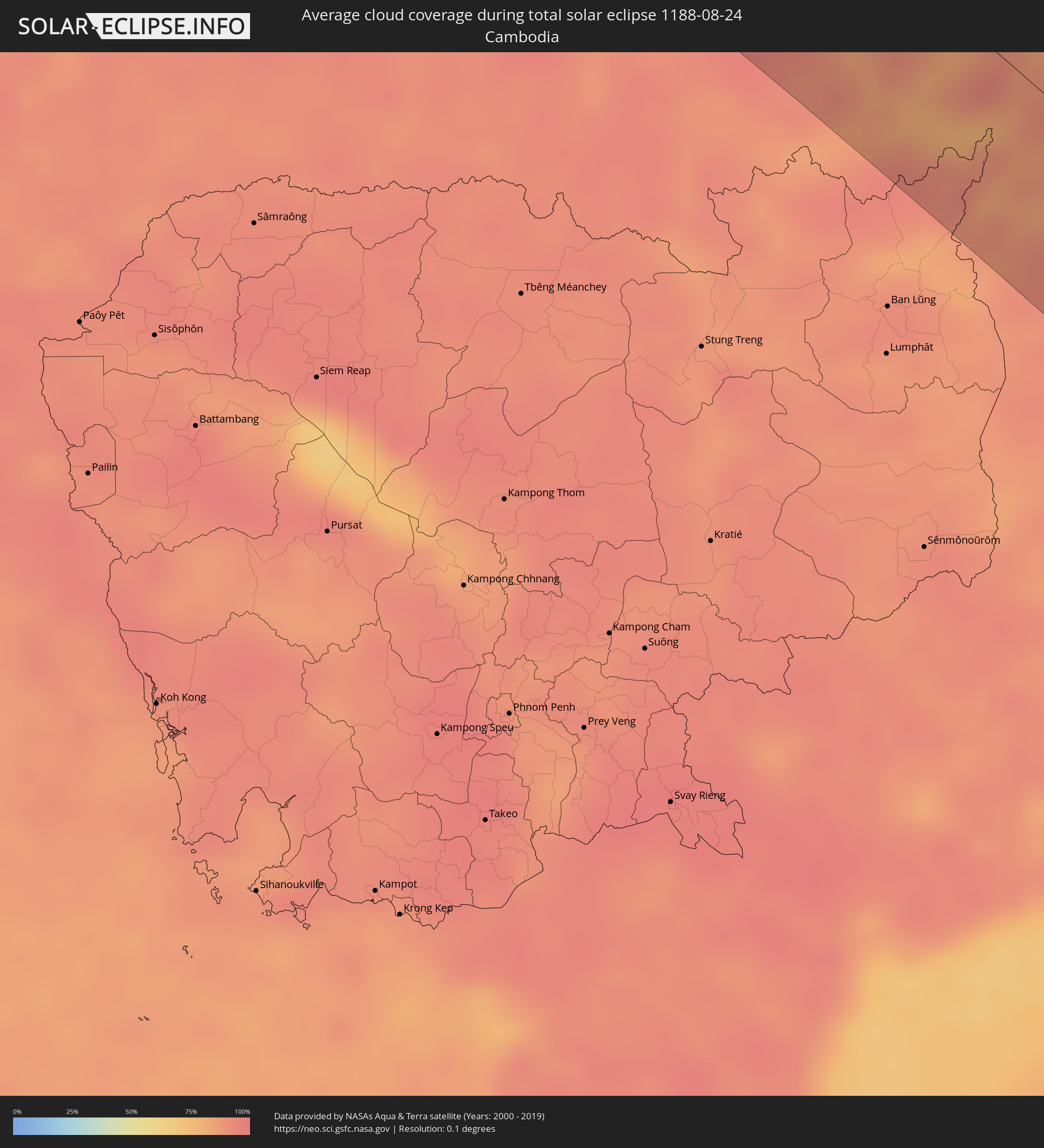 Cambodia
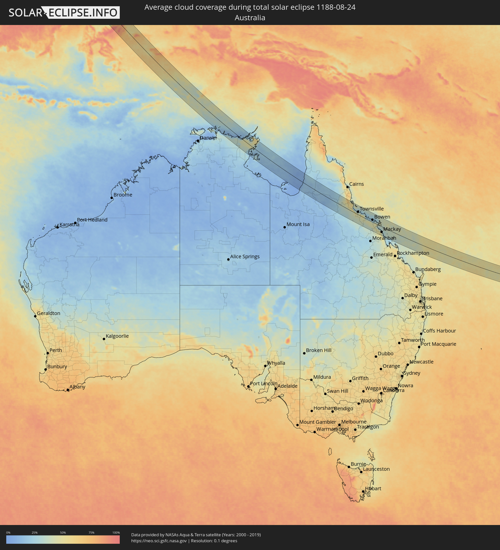 Australia
Cities inside the path of the eclipse
The following table shows all locations with a population of more than 5,000 inside the eclipse path. Cities which have more than 100,000 inhabitants are marked bold. A click at the locations opens a detailed map.
| City | Type | Eclipse duration | Local time of max. eclipse | Distance to central line | Ø Cloud coverage |
|
Mulayjah, Eastern Province
|
total | - | 05:43:24 UTC+03:06 | 4 km | 1% |
|
Al Jubayl, Eastern Province
|
total | - | 05:43:26 UTC+03:06 | 44 km | 17% |
|
Gerāsh, Fars
|
total | - | 06:03:00 UTC+03:25 | 30 km | 2% |
|
Khāsh, Sistan and Baluchestan
|
total | - | 06:05:17 UTC+03:25 | 25 km | 5% |
|
Shahdād Kot, Sindh
|
total | - | 07:11:24 UTC+04:28 | 74 km | 43% |
|
Usta Muhammad, Balochistān
|
total | - | 07:11:28 UTC+04:28 | 37 km | 45% |
|
Ratodero, Sindh
|
total | - | 07:11:39 UTC+04:28 | 78 km | 45% |
|
Jacobābād, Sindh
|
total | - | 07:11:43 UTC+04:28 | 25 km | 43% |
|
Shikārpur, Sindh
|
total | - | 07:11:53 UTC+04:28 | 60 km | 44% |
|
Thul, Sindh
|
total | - | 07:11:57 UTC+04:28 | 28 km | 44% |
|
Pāno Āqil, Sindh
|
total | - | 07:12:13 UTC+04:28 | 70 km | 50% |
|
Kandhkot, Sindh
|
total | - | 07:12:14 UTC+04:28 | 26 km | 51% |
|
Ghotki, Sindh
|
total | - | 07:12:21 UTC+04:28 | 52 km | 48% |
|
Mīrpur Mathelo, Sindh
|
total | - | 07:12:31 UTC+04:28 | 50 km | 46% |
|
Kashmor, Sindh
|
total | - | 07:12:31 UTC+04:28 | 4 km | 58% |
|
Khairpur, Sindh
|
total | - | 07:12:38 UTC+04:28 | 44 km | 44% |
|
Sādiqābād, Punjab
|
total | - | 07:12:55 UTC+04:28 | 15 km | 50% |
|
Rājanpur, Punjab
|
total | - | 07:13:00 UTC+04:28 | 74 km | 40% |
|
Zāhir Pīr, Punjab
|
total | - | 07:13:10 UTC+04:28 | 43 km | 45% |
|
Khānpur, Punjab
|
total | - | 07:13:17 UTC+04:28 | 25 km | 49% |
|
Bīkaner, Rajasthan
|
total | - | 08:08:28 UTC+05:21 | 25 km | 57% |
|
Alwar, Rajasthan
|
total | - | 08:11:37 UTC+05:21 | 38 km | 80% |
|
Farīdābād, Haryana
|
total | - | 08:12:04 UTC+05:21 | 65 km | 80% |
|
Noida, Uttar Pradesh
|
total | - | 08:12:03 UTC+05:21 | 84 km | 78% |
|
Greater Noida, Uttar Pradesh
|
total | - | 08:12:16 UTC+05:21 | 77 km | 83% |
|
Mathura, Uttar Pradesh
|
total | - | 08:12:41 UTC+05:21 | 30 km | 83% |
|
Āgra, Uttar Pradesh
|
total | - | 08:13:08 UTC+05:21 | 60 km | 84% |
|
Alīgarh, Uttar Pradesh
|
total | - | 08:12:59 UTC+05:21 | 18 km | 83% |
|
Fīrozābād, Uttar Pradesh
|
total | - | 08:13:33 UTC+05:21 | 58 km | 85% |
|
Shāhjānpur, Uttar Pradesh
|
total | - | 08:14:56 UTC+05:21 | 48 km | 83% |
|
Lucknow, Uttar Pradesh
|
total | - | 08:16:28 UTC+05:21 | 46 km | 89% |
|
Gorakhpur, Uttar Pradesh
|
total | - | 08:19:26 UTC+05:21 | 1 km | 89% |
|
Bhairāhawā, Western Region
|
total | - | 08:39:17 UTC+05:41 | 80 km | 84% |
|
Bīrganj, Central Region
|
total | - | 08:41:18 UTC+05:41 | 62 km | 89% |
|
Patna, Bihar
|
total | - | 08:22:21 UTC+05:21 | 83 km | 93% |
|
Gaur, Central Region
|
total | - | 08:41:58 UTC+05:41 | 46 km | 93% |
|
Muzaffarpur, Bihar
|
total | - | 08:22:22 UTC+05:21 | 20 km | 94% |
|
Malangwa, Central Region
|
total | - | 08:42:16 UTC+05:41 | 64 km | 92% |
|
Jaleswar, Central Region
|
total | - | 08:42:43 UTC+05:41 | 48 km | 95% |
|
Darbhanga, Bihar
|
total | - | 08:23:02 UTC+05:21 | 2 km | 94% |
|
Janakpur, Central Region
|
total | - | 08:42:49 UTC+05:41 | 58 km | 94% |
|
Sirāhā, Eastern Region
|
total | - | 08:43:15 UTC+05:41 | 60 km | 95% |
|
Lahān, Eastern Region
|
total | - | 08:43:35 UTC+05:41 | 76 km | 92% |
|
Rājbirāj, Eastern Region
|
total | - | 08:44:03 UTC+05:41 | 62 km | 90% |
|
Bhāgalpur, Bihar
|
total | - | 08:25:05 UTC+05:21 | 68 km | 96% |
|
Biratnagar, Eastern Region
|
total | - | 08:44:48 UTC+05:41 | 69 km | 94% |
|
Dinājpur, Rangpur Division
|
total | - | 08:59:21 UTC+05:53 | 24 km | 96% |
|
Saidpur, Rājshāhi
|
total | - | 08:59:37 UTC+05:53 | 49 km | 97% |
|
Pār Naogaon, Rājshāhi
|
total | - | 09:00:25 UTC+05:53 | 52 km | 94% |
|
Rangpur, Rangpur Division
|
total | - | 09:00:09 UTC+05:53 | 57 km | 95% |
|
Bogra, Rājshāhi
|
total | - | 09:01:01 UTC+05:53 | 33 km | 97% |
|
Sirājganj, Rājshāhi
|
total | - | 09:01:50 UTC+05:53 | 62 km | 95% |
|
Sarishābāri, Dhaka
|
total | - | 09:01:47 UTC+05:53 | 27 km | 95% |
|
Tāngāil, Dhaka
|
total | - | 09:02:19 UTC+05:53 | 77 km | 97% |
|
Jamālpur, Dhaka
|
total | - | 09:01:49 UTC+05:53 | 6 km | 97% |
|
Mymensingh, Dhaka
|
total | - | 09:02:38 UTC+05:53 | 6 km | 97% |
|
Narsingdi, Dhaka
|
total | - | 09:03:49 UTC+05:53 | 82 km | 93% |
|
Netrakona, Dhaka
|
total | - | 09:03:02 UTC+05:53 | 19 km | 97% |
|
Kishorganj, Dhaka
|
total | - | 09:03:29 UTC+05:53 | 26 km | 95% |
|
Bhairab Bāzār, Dhaka
|
total | - | 09:04:07 UTC+05:53 | 58 km | 91% |
|
Habiganj, Sylhet
|
total | - | 09:04:30 UTC+05:53 | 8 km | 96% |
|
Sylhet, Sylhet
|
total | - | 09:04:46 UTC+05:53 | 63 km | 95% |
|
Falam, Chin
|
total | - | 09:41:00 UTC+06:24 | 67 km | 96% |
|
Mawlaik, Sagain
|
total | - | 09:41:27 UTC+06:24 | 38 km | 91% |
|
Monywa, Sagain
|
total | - | 09:44:19 UTC+06:24 | 83 km | 96% |
|
Shwebo, Sagain
|
total | - | 09:44:46 UTC+06:24 | 11 km | 97% |
|
Sagaing, Sagain
|
total | - | 09:46:03 UTC+06:24 | 67 km | 94% |
|
Mandalay, Mandalay
|
total | - | 09:46:07 UTC+06:24 | 52 km | 96% |
|
Kyaukse, Mandalay
|
total | - | 09:46:38 UTC+06:24 | 86 km | 97% |
|
Pyin Oo Lwin, Mandalay
|
total | - | 09:46:41 UTC+06:24 | 28 km | 96% |
|
Mogok, Mandalay
|
total | - | 09:45:46 UTC+06:24 | 61 km | 93% |
|
Chiang Rai, Chiang Rai
|
total | - | 10:12:46 UTC+06:42 | 59 km | 95% |
|
Mae Chan, Chiang Rai
|
total | - | 10:12:29 UTC+06:42 | 35 km | 94% |
|
Mae Sai, Chiang Rai
|
total | - | 10:12:08 UTC+06:42 | 7 km | 93% |
|
Tachilek, Shan
|
total | - | 10:12:07 UTC+06:42 | 5 km | 93% |
|
Chiang Kham, Phayao
|
total | - | 10:14:11 UTC+06:42 | 69 km | 95% |
|
Chiang Khong, Chiang Rai
|
total | - | 10:13:20 UTC+06:42 | 6 km | 89% |
|
Ban Houayxay, Bokeo Province
|
total | - | 10:13:20 UTC+06:42 | 8 km | 89% |
|
Ban Houakhoua, Bokeo Province
|
total | - | 10:13:27 UTC+06:42 | 8 km | 89% |
|
Sainyabuli, Xiagnabouli
|
total | - | 10:17:13 UTC+06:42 | 12 km | 88% |
|
Luang Prabang, Louangphabang
|
total | - | 10:17:05 UTC+06:42 | 71 km | 86% |
|
Muang Phôn-Hông, Vientiane Province
|
total | - | 10:19:42 UTC+06:42 | 40 km | 91% |
|
Vangviang, Vientiane Province
|
total | - | 10:19:07 UTC+06:42 | 1 km | 89% |
|
Tha Bo, Nong Khai
|
total | - | 10:21:02 UTC+06:42 | 89 km | 90% |
|
Vientiane, Vientiane
|
total | - | 10:20:53 UTC+06:42 | 77 km | 93% |
|
Nong Khai, Nong Khai
|
total | - | 10:21:18 UTC+06:42 | 76 km | 92% |
|
Phon Charoen, Nong Khai
|
total | - | 10:21:52 UTC+06:42 | 36 km | 91% |
|
Muang Phônsavan, Xiangkhoang
|
total | - | 10:19:46 UTC+06:42 | 95 km | 91% |
|
Ban Dung, Changwat Udon Thani
|
total | - | 10:22:34 UTC+06:42 | 60 km | 92% |
|
Sawang Daen Din, Sakon Nakhon
|
total | - | 10:23:19 UTC+06:42 | 68 km | 92% |
|
Muang Pakxan, Bolikhamsai Province
|
total | - | 10:22:15 UTC+06:42 | 26 km | 85% |
|
Seka, Changwat Bueng Kan
|
total | - | 10:23:33 UTC+06:42 | 4 km | 86% |
|
Khao Wong, Kalasin
|
total | - | 10:25:49 UTC+06:42 | 97 km | 91% |
|
Sakon Nakhon, Sakon Nakhon
|
total | - | 10:25:10 UTC+06:42 | 52 km | 91% |
|
That Phanom, Nakhon Phanom
|
total | - | 10:26:38 UTC+06:42 | 36 km | 89% |
|
Mukdahan, Mukdahan
|
total | - | 10:27:19 UTC+06:42 | 69 km | 92% |
|
Savannakhét, Savannahkhét
|
total | - | 10:27:20 UTC+06:42 | 65 km | 91% |
|
Nakhon Phanom, Nakhon Phanom
|
total | - | 10:25:59 UTC+06:42 | 11 km | 89% |
|
Thakhèk, Khammouan
|
total | - | 10:26:05 UTC+06:42 | 14 km | 89% |
|
Salavan, Salavan
|
total | - | 10:32:04 UTC+06:42 | 27 km | 88% |
|
Lamam, Xékong
|
total | - | 10:33:09 UTC+06:42 | 34 km | 83% |
|
Attapu, Attapu
|
total | - | 10:34:30 UTC+06:42 | 76 km | 85% |
|
Pleiku, Gia Lai
|
total | - | 11:02:56 UTC+07:06 | 63 km | 91% |
|
Kon Tum, Kon Tum
|
total | - | 11:02:16 UTC+07:06 | 31 km | 81% |
|
Quảng Ngãi, Quảng Ngãi
|
total | - | 11:02:24 UTC+07:06 | 88 km | 73% |
|
Sông Cầu, Phú Yên
|
total | - | 11:06:21 UTC+07:06 | 18 km | 85% |
|
Qui Nhon, Bình Định
|
total | - | 11:05:45 UTC+07:06 | 8 km | 82% |
|
Tuy Hòa, Phú Yên
|
total | - | 11:07:14 UTC+07:06 | 40 km | 80% |
|
Papar, Sabah
|
total | - | 11:49:41 UTC+07:21 | 95 km | 75% |
|
Kinarut, Sabah
|
total | - | 11:49:43 UTC+07:21 | 79 km | 78% |
|
Putatan, Sabah
|
total | - | 11:49:32 UTC+07:21 | 70 km | 81% |
|
Kota Kinabalu, Sabah
|
total | - | 11:49:27 UTC+07:21 | 66 km | 85% |
|
Donggongon, Sabah
|
total | - | 11:49:39 UTC+07:21 | 69 km | 81% |
|
Kota Belud, Sabah
|
total | - | 11:49:21 UTC+07:21 | 8 km | 81% |
|
Ranau, Sabah
|
total | - | 11:50:37 UTC+07:21 | 19 km | 82% |
|
Kudat, Sabah
|
total | - | 11:48:59 UTC+07:21 | 64 km | 79% |
|
Tawau, Sabah
|
total | - | 11:56:27 UTC+07:21 | 46 km | 80% |
|
Taman Rajawali, Sabah
|
total | - | 11:53:20 UTC+07:21 | 90 km | 78% |
|
Sandakan, Sabah
|
total | - | 11:53:35 UTC+07:21 | 92 km | 77% |
|
Lahad Datu, Sabah
|
total | - | 11:55:39 UTC+07:21 | 48 km | 72% |
|
Semporna, Sabah
|
total | - | 04:35:58 UTC+00:00 | 31 km | 80% |
|
Luwuk, Central Sulawesi
|
total | - | 12:51:57 UTC+07:57 | 30 km | 83% |
|
Ingham, Queensland
|
total | - | 15:49:34 UTC+10:00 | 53 km | 54% |
|
Charters Towers, Queensland
|
total | - | 15:50:47 UTC+10:00 | 82 km | 32% |
|
Townsville, Queensland
|
total | - | 15:50:35 UTC+10:00 | 24 km | 44% |
|
Ayr, Queensland
|
total | - | 15:51:17 UTC+10:00 | 23 km | 43% |
|
Bowen, Queensland
|
total | - | 15:52:14 UTC+10:00 | 20 km | 30% |
|
Red Hill, Queensland
|
total | - | 15:52:38 UTC+10:00 | 2 km | 46% |
|
Mackay, Queensland
|
total | - | 15:53:41 UTC+10:00 | 51 km | 38% |