Hybrid solar eclipse of 08/26/1318
| Day of week: | Friday |
| Maximum duration of eclipse: | 01m06s |
| Maximum width of eclipse path: | 42 km |
| Saros cycle: | 114 |
| Coverage: | 100% |
| Magnitude: | 1.012 |
| Gamma: | 0.2005 |
Wo kann man die Sonnenfinsternis vom 08/26/1318 sehen?
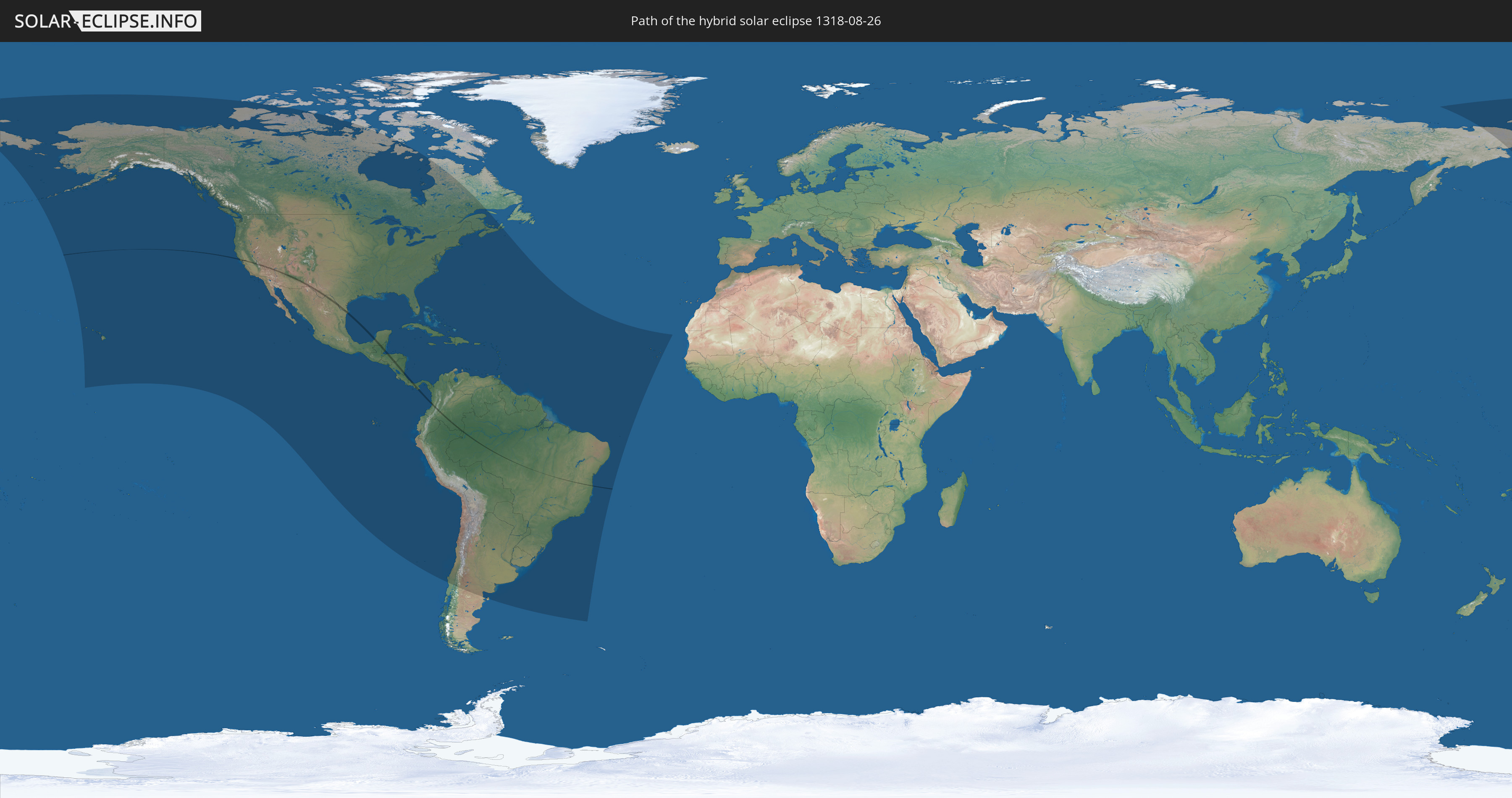
Die Sonnenfinsternis am 08/26/1318 kann man in 53 Ländern als partielle Sonnenfinsternis beobachten.
Der Finsternispfad verläuft durch 10 Länder. Nur in diesen Ländern ist sie als hybrid Sonnenfinsternis zu sehen.
In den folgenden Ländern ist die Sonnenfinsternis hybrid zu sehen
 United States
 Mexico
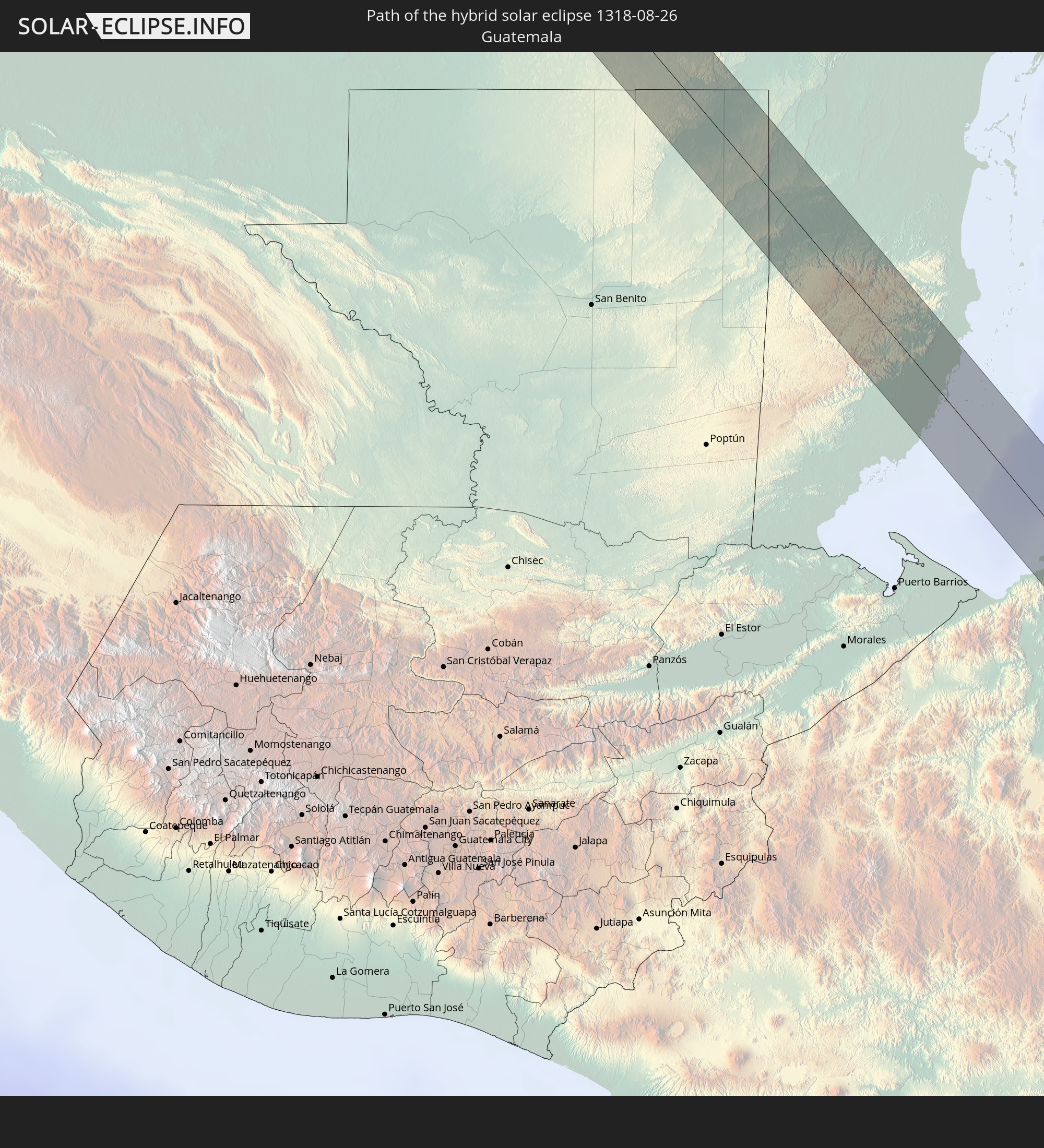 Guatemala
 Honduras
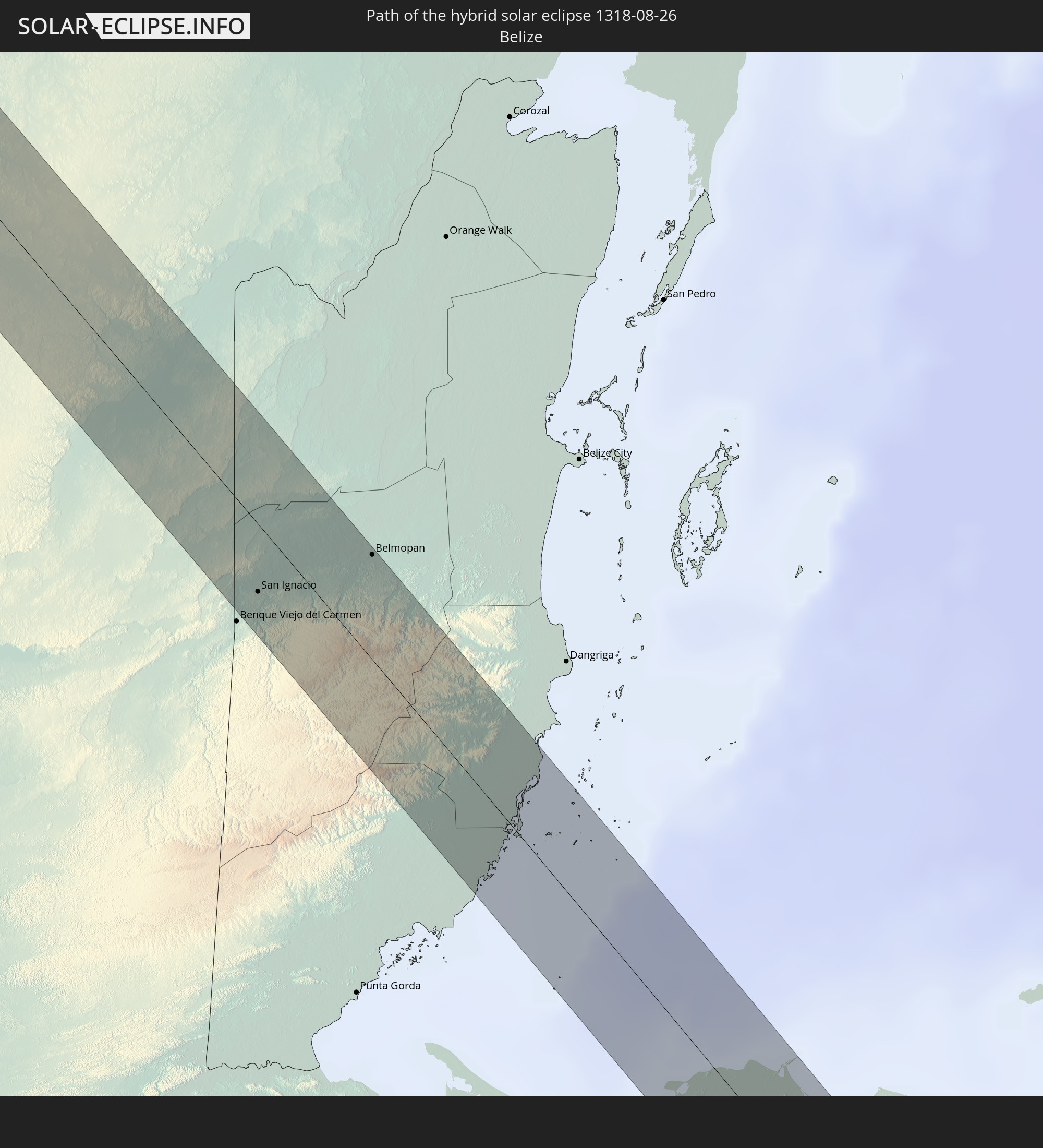 Belize
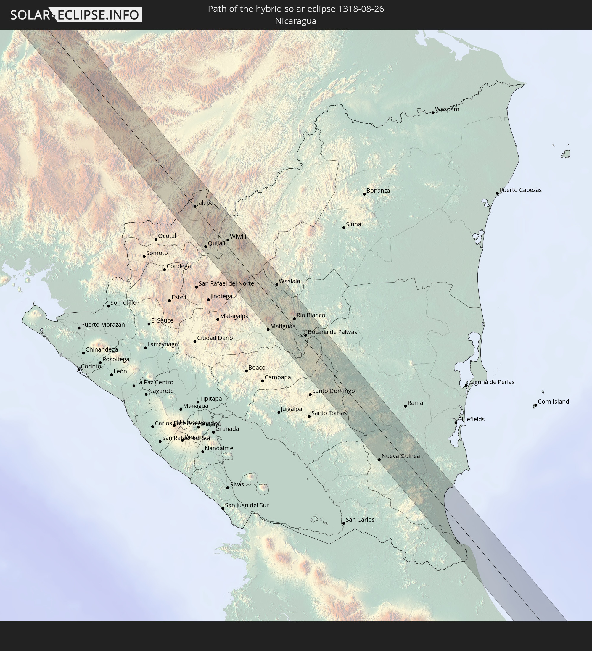 Nicaragua
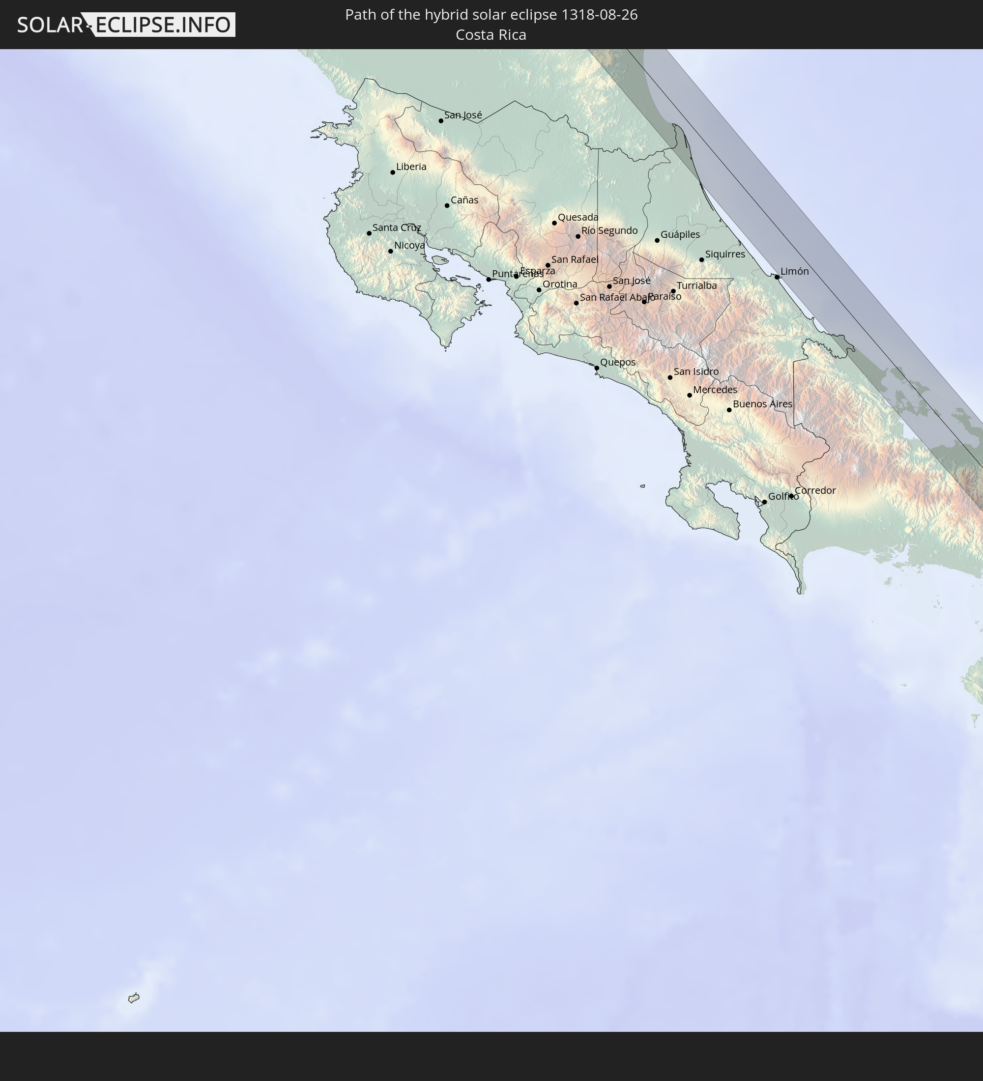 Costa Rica
 Panama
 Colombia
 Brazil
In den folgenden Ländern ist die Sonnenfinsternis partiell zu sehen
 Russia
 United States
 United States Minor Outlying Islands
 Canada
 Mexico
 Chile
Chile
 Greenland
 Guatemala
 Ecuador
 El Salvador
 Honduras
 Belize
 Nicaragua
 Costa Rica
 Cuba
Cuba
 Panama
 Colombia
 Cayman Islands
 Peru
Peru
 The Bahamas
 Jamaica
 Haiti
Haiti
 Brazil
 Argentina
 Venezuela
 Turks and Caicos Islands
 Dominican Republic
 Aruba
Aruba
 Bolivia
 Puerto Rico
 United States Virgin Islands
 Bermuda
 British Virgin Islands
 Anguilla
 Collectivity of Saint Martin
 Saint Barthélemy
 Saint Kitts and Nevis
 Paraguay
 Antigua and Barbuda
 Montserrat
 Trinidad and Tobago
 Guadeloupe
 Grenada
 Dominica
 Saint Vincent and the Grenadines
 Guyana
 Martinique
 Saint Lucia
 Barbados
 Uruguay
 Suriname
 French Guiana
 Cabo Verde
How will be the weather during the hybrid solar eclipse on 08/26/1318?
Where is the best place to see the hybrid solar eclipse of 08/26/1318?
The following maps show the average cloud coverage for the day of the hybrid solar eclipse.
With the help of these maps, it is possible to find the place along the eclipse path, which has the best
chance of a cloudless sky.
Nevertheless, you should consider local circumstances and inform about the weather of your chosen
observation site.
The data is provided by NASAs satellites
AQUA and TERRA.
The cloud maps are averaged over a period of 19 years (2000 - 2019).


Detailed country maps
 United States
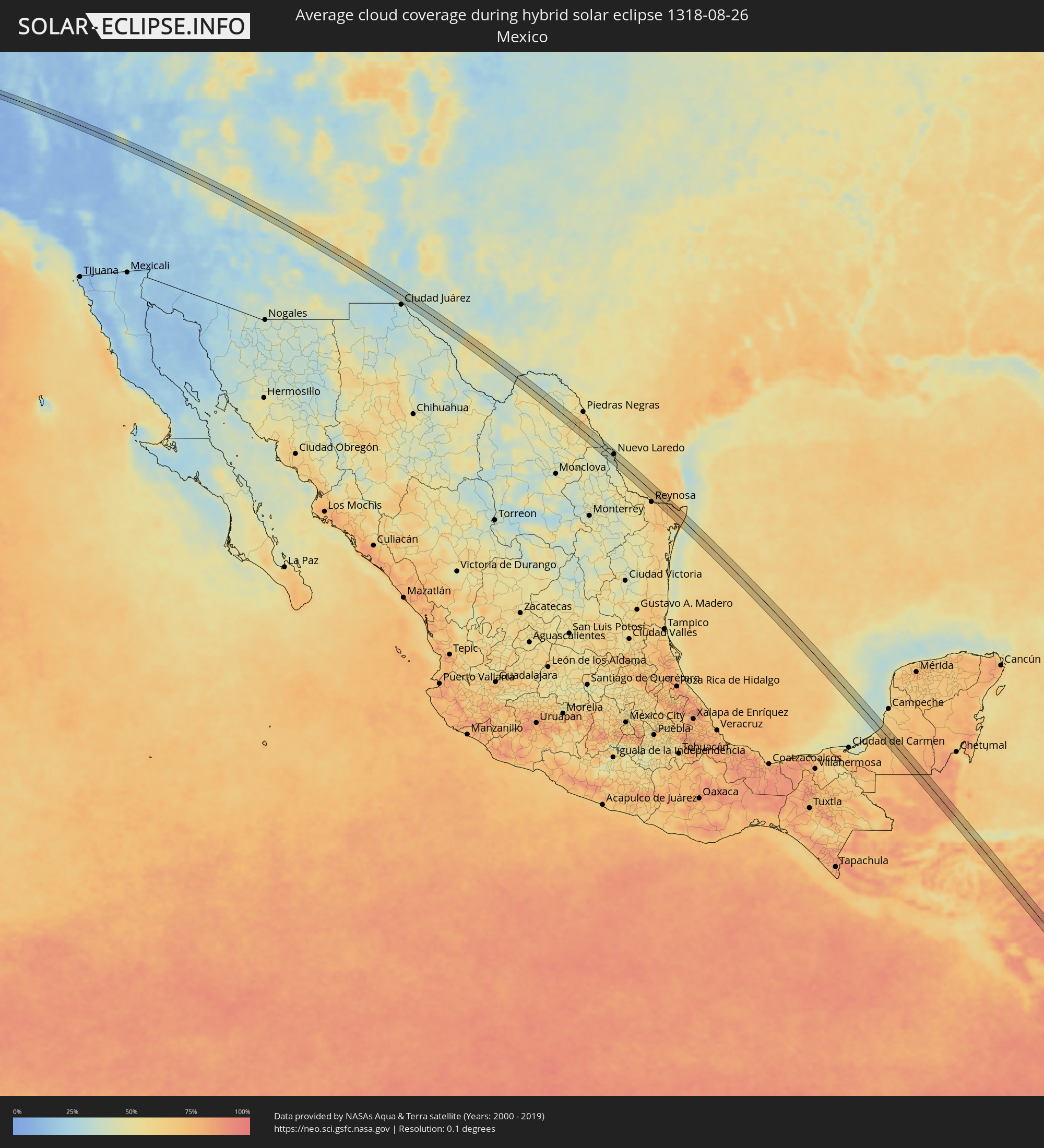 Mexico
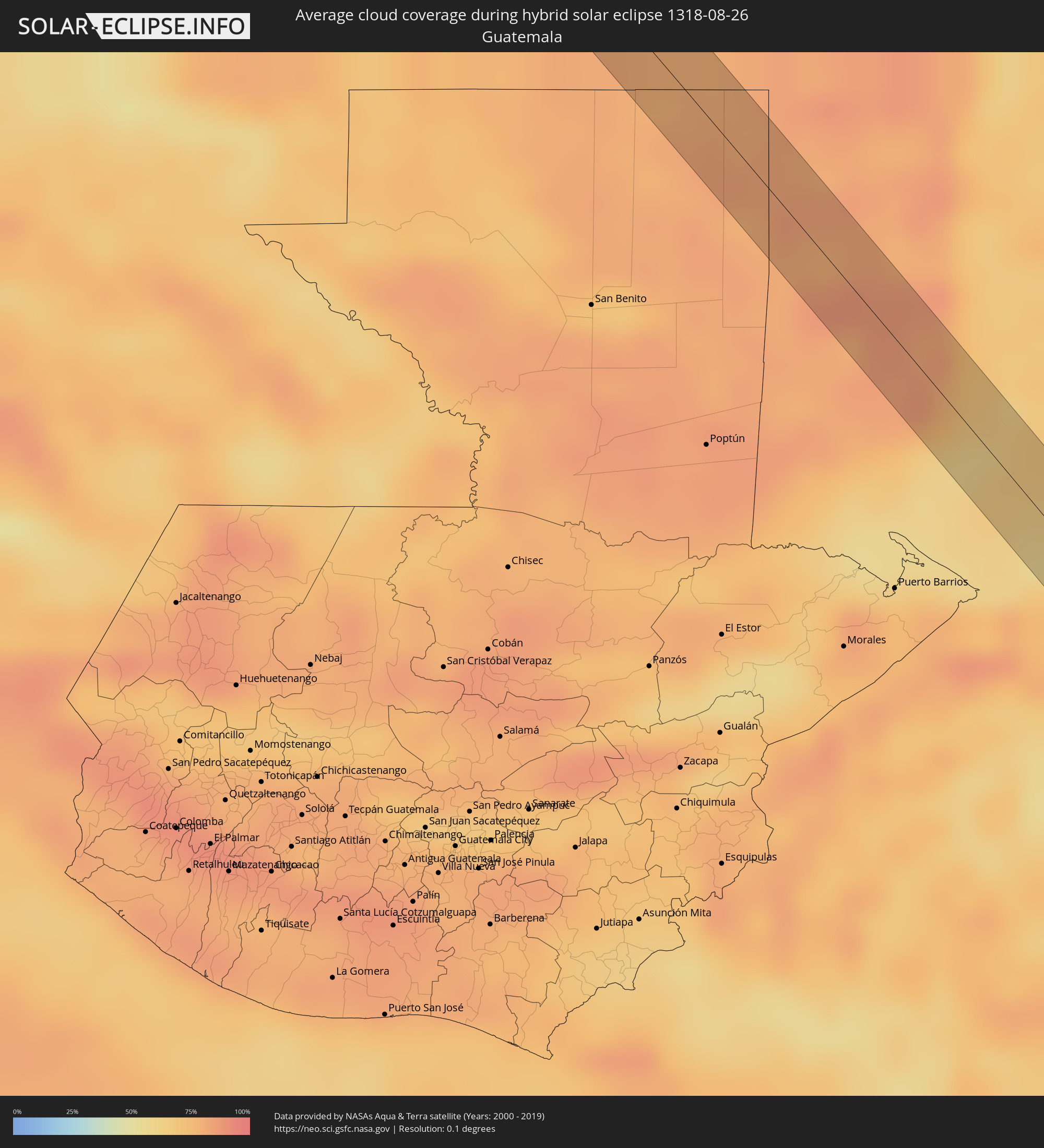 Guatemala
 Honduras
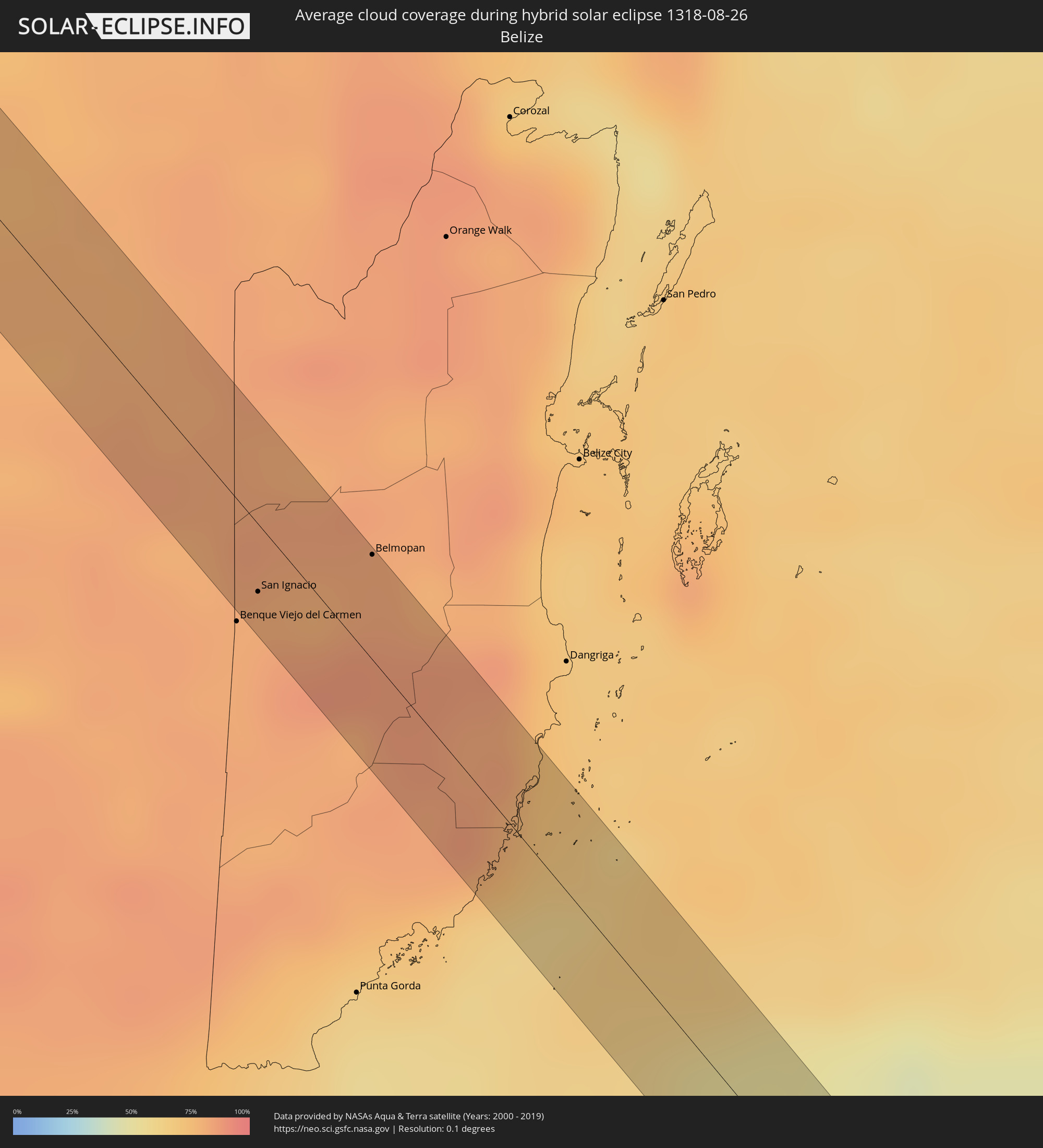 Belize
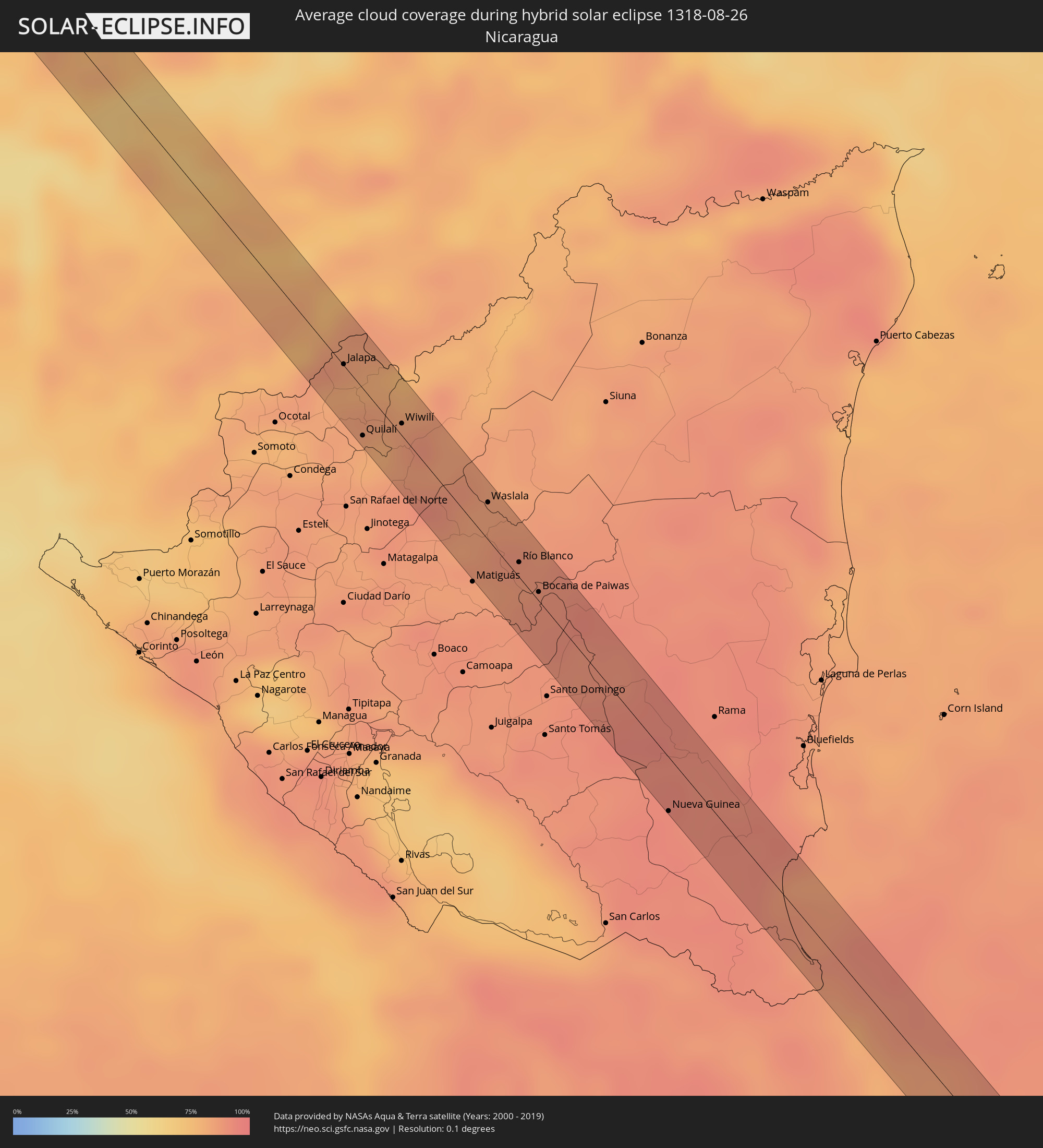 Nicaragua
 Costa Rica
 Panama
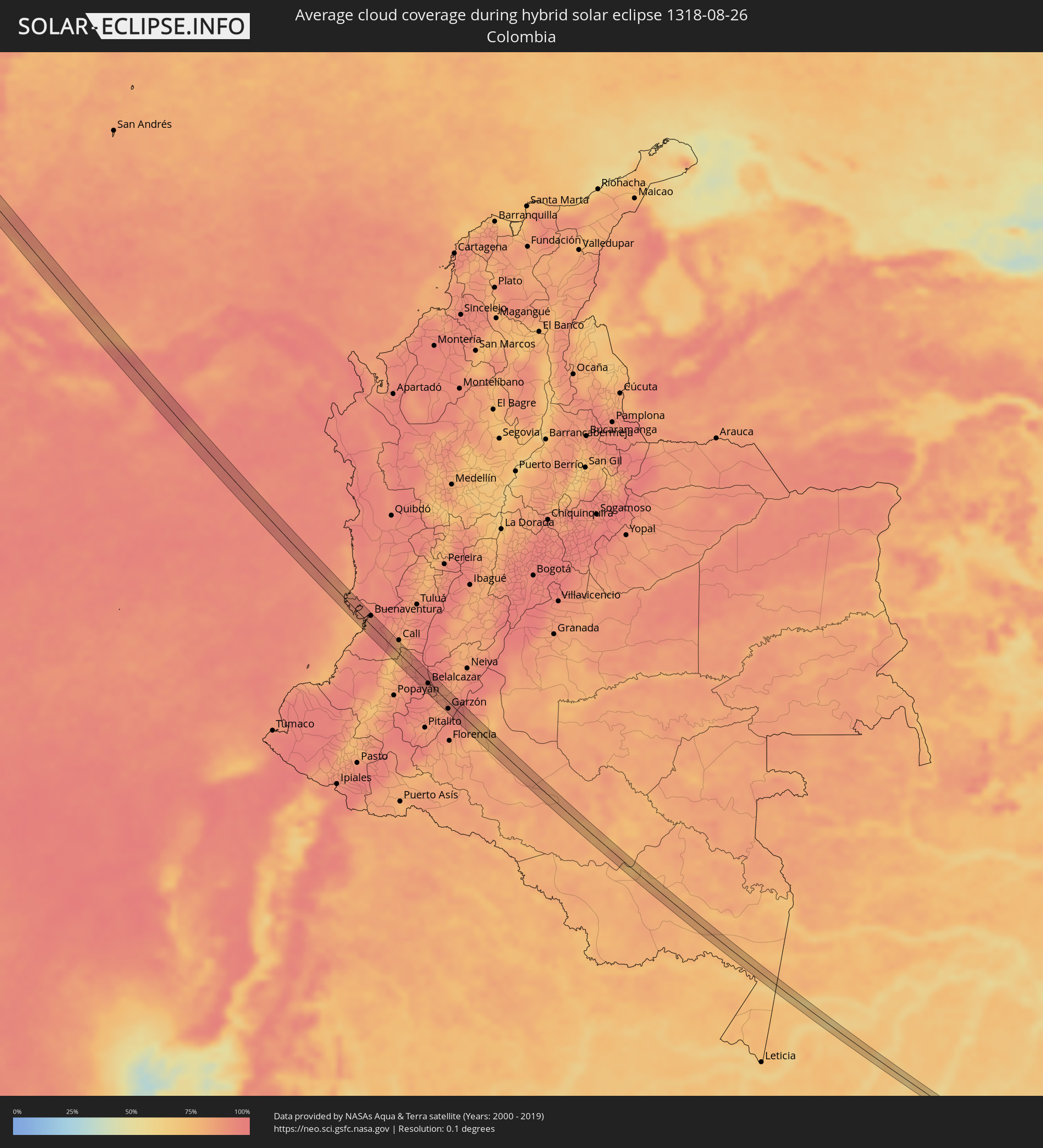 Colombia
 Brazil
Cities inside the path of the eclipse
The following table shows all locations with a population of more than 5,000 inside the eclipse path. Cities which have more than 100,000 inhabitants are marked bold. A click at the locations opens a detailed map.
| City | Type | Eclipse duration | Local time of max. eclipse | Distance to central line | Ø Cloud coverage |
|
Petaluma, California
|
total | - | 08:55:25 UTC-08:00 | 4 km | 9% |
|
Novato, California
|
total | - | 08:55:31 UTC-08:00 | 8 km | 9% |
|
Rodeo, California
|
total | - | 08:55:54 UTC-08:00 | 8 km | 16% |
|
Vallejo, California
|
total | - | 08:55:54 UTC-08:00 | 0 km | 10% |
|
Concord, California
|
total | - | 08:56:12 UTC-08:00 | 8 km | 6% |
|
Antioch, California
|
total | - | 08:56:27 UTC-08:00 | 1 km | 4% |
|
Discovery Bay, California
|
total | - | 08:56:44 UTC-08:00 | 3 km | 4% |
|
Country Club, California
|
total | - | 08:57:02 UTC-08:00 | 10 km | 5% |
|
Stockton, California
|
total | - | 08:57:06 UTC-08:00 | 10 km | 5% |
|
Manteca, California
|
total | - | 08:57:14 UTC-08:00 | 5 km | 5% |
|
Riverbank, California
|
total | - | 08:57:36 UTC-08:00 | 3 km | 6% |
|
Pahrump, Nevada
|
total | - | 09:04:48 UTC-08:00 | 4 km | 10% |
|
Spring Valley, Nevada
|
total | - | 09:05:54 UTC-08:00 | 12 km | 16% |
|
Chino Valley, Arizona
|
total | - | 10:10:57 UTC-07:00 | 14 km | 38% |
|
Verde Village, Arizona
|
total | - | 10:11:40 UTC-07:00 | 0 km | 35% |
|
Camp Verde, Arizona
|
total | - | 10:12:02 UTC-07:00 | 8 km | 36% |
|
Las Cruces, New Mexico
|
total | - | 10:22:27 UTC-07:00 | 14 km | 33% |
|
Anthony, New Mexico
|
total | - | 10:23:06 UTC-07:00 | 6 km | 37% |
|
Fort Bliss, Texas
|
total | - | 10:23:39 UTC-07:00 | 14 km | 36% |
|
Chaparral, New Mexico
|
total | - | 10:23:27 UTC-07:00 | 7 km | 34% |
|
Horizon City, Texas
|
total | - | 10:24:09 UTC-07:00 | 14 km | 35% |
|
Zaragoza, Coahuila
|
total | - | 11:01:22 UTC-06:36 | 5 km | 53% |
|
Allende, Coahuila
|
total | - | 11:01:44 UTC-06:36 | 4 km | 54% |
|
Nava, Coahuila
|
total | - | 11:01:46 UTC-06:36 | 8 km | 59% |
|
Villa Union, Coahuila
|
total | - | 11:02:11 UTC-06:36 | 6 km | 53% |
|
El Campanario y Oradel, Tamaulipas
|
total | - | 11:05:24 UTC-06:36 | 1 km | 41% |
|
Nuevo Laredo, Tamaulipas
|
total | - | 11:05:35 UTC-06:36 | 8 km | 45% |
|
Laredo, Texas
|
total | - | 11:42:09 UTC-06:00 | 11 km | 45% |
|
McAllen, Texas
|
total | - | 11:46:46 UTC-06:00 | 12 km | 64% |
|
Weslaco, Texas
|
total | - | 11:47:17 UTC-06:00 | 1 km | 63% |
|
Heroica Matamoros, Tamaulipas
|
total | - | 11:12:06 UTC-06:36 | 11 km | 73% |
|
Brownsville, Texas
|
total | - | 11:48:41 UTC-06:00 | 13 km | 73% |
|
Champotón, Campeche
|
total | - | 11:37:58 UTC-06:36 | 14 km | 63% |
|
San Ignacio, Cayo
|
total | - | 12:29:39 UTC-05:52 | 13 km | 81% |
|
Belmopan, Cayo
|
total | - | 12:30:01 UTC-05:52 | 20 km | 82% |
|
Puerto Cortez, Cortés
|
total | - | 12:38:40 UTC-05:48 | 14 km | 68% |
|
Baracoa, Cortés
|
total | - | 12:38:57 UTC-05:48 | 11 km | 68% |
|
Mezapa, Atlántida
|
total | - | 12:39:44 UTC-05:48 | 8 km | 75% |
|
Tela, Atlántida
|
total | - | 12:39:38 UTC-05:48 | 21 km | 63% |
|
Santa Rita, Yoro
|
total | - | 12:41:20 UTC-05:48 | 7 km | 68% |
|
Yoro, Yoro
|
total | - | 12:41:41 UTC-05:48 | 4 km | 77% |
|
Guaimaca, Francisco Morazán
|
total | - | 12:43:36 UTC-05:48 | 14 km | 77% |
|
Campamento, Olancho
|
total | - | 12:43:52 UTC-05:48 | 1 km | 77% |
|
Jalapa, Nueva Segovia
|
total | - | 12:49:54 UTC-05:45 | 1 km | 81% |
|
Quilalí, Nueva Segovia
|
total | - | 12:50:53 UTC-05:45 | 17 km | 82% |
|
Wiwilí, Nueva Segovia
|
total | - | 12:51:06 UTC-05:45 | 4 km | 86% |
|
Waslala, Atlántico Norte (RAAN)
|
total | - | 12:52:47 UTC-05:45 | 13 km | 85% |
|
Río Blanco, Matagalpa
|
total | - | 12:53:44 UTC-05:45 | 5 km | 87% |
|
Bocana de Paiwas, Atlántico Sur
|
total | - | 12:54:15 UTC-05:45 | 3 km | 90% |
|
Nueva Guinea, Atlántico Sur
|
total | - | 12:57:54 UTC-05:45 | 19 km | 93% |
|
Changuinola, Bocas del Toro
|
total | - | 13:31:53 UTC-05:19 | 20 km | 89% |
|
Almirante, Bocas del Toro
|
total | - | 13:32:22 UTC-05:19 | 19 km | 86% |
|
Bocas del Toro, Bocas del Toro
|
total | - | 13:32:33 UTC-05:19 | 3 km | 86% |
|
Santiago de Veraguas, Veraguas
|
total | - | 13:37:22 UTC-05:19 | 11 km | 93% |
|
Buenaventura, Valle del Cauca
|
total | - | 14:15:48 UTC-04:56 | 13 km | 91% |
|
Buenaventura, Valle del Cauca
|
total | - | 14:16:27 UTC-04:56 | 7 km | 96% |
|
Jamundí, Valle del Cauca
|
total | - | 14:17:46 UTC-04:56 | 4 km | 78% |
|
Santander de Quilichao, Cauca
|
total | - | 14:18:21 UTC-04:56 | 12 km | 84% |
|
Puerto Tejada, Cauca
|
total | - | 14:18:00 UTC-04:56 | 11 km | 83% |
|
Caloto, Cauca
|
total | - | 14:18:25 UTC-04:56 | 4 km | 90% |
|
Belalcazar, Cauca
|
total | - | 14:19:46 UTC-04:56 | 2 km | 92% |
|
La Plata, Huila
|
total | - | 14:20:26 UTC-04:56 | 15 km | 91% |
|
Garzón, Huila
|
total | - | 14:21:12 UTC-04:56 | 10 km | 91% |
|
Gigante, Huila
|
total | - | 14:20:56 UTC-04:56 | 11 km | 93% |
|
Puerto Rico, Caquetá
|
total | - | 14:22:25 UTC-04:56 | 4 km | 77% |
|
São Paulo de Olivença, Amazonas
|
total | - | 15:33:24 UTC-04:02 | 3 km | 62% |
|
Carauari, Amazonas
|
total | - | 15:37:54 UTC-04:02 | 7 km | 56% |
|
Pau Brasil, Bahia
|
annular | - | 17:32:09 UTC-02:34 | 5 km | 73% |
|
Mascote, Bahia
|
annular | - | 17:32:14 UTC-02:34 | 2 km | 81% |
|
Canavieiras, Bahia
|
annular | - | 17:32:19 UTC-02:34 | 3 km | 51% |