Total solar eclipse of 04/21/1697
| Day of week: | Sunday |
| Maximum duration of eclipse: | 04m18s |
| Maximum width of eclipse path: | 262 km |
| Saros cycle: | 114 |
| Coverage: | 100% |
| Magnitude: | 1.0602 |
| Gamma: | 0.6559 |
Wo kann man die Sonnenfinsternis vom 04/21/1697 sehen?
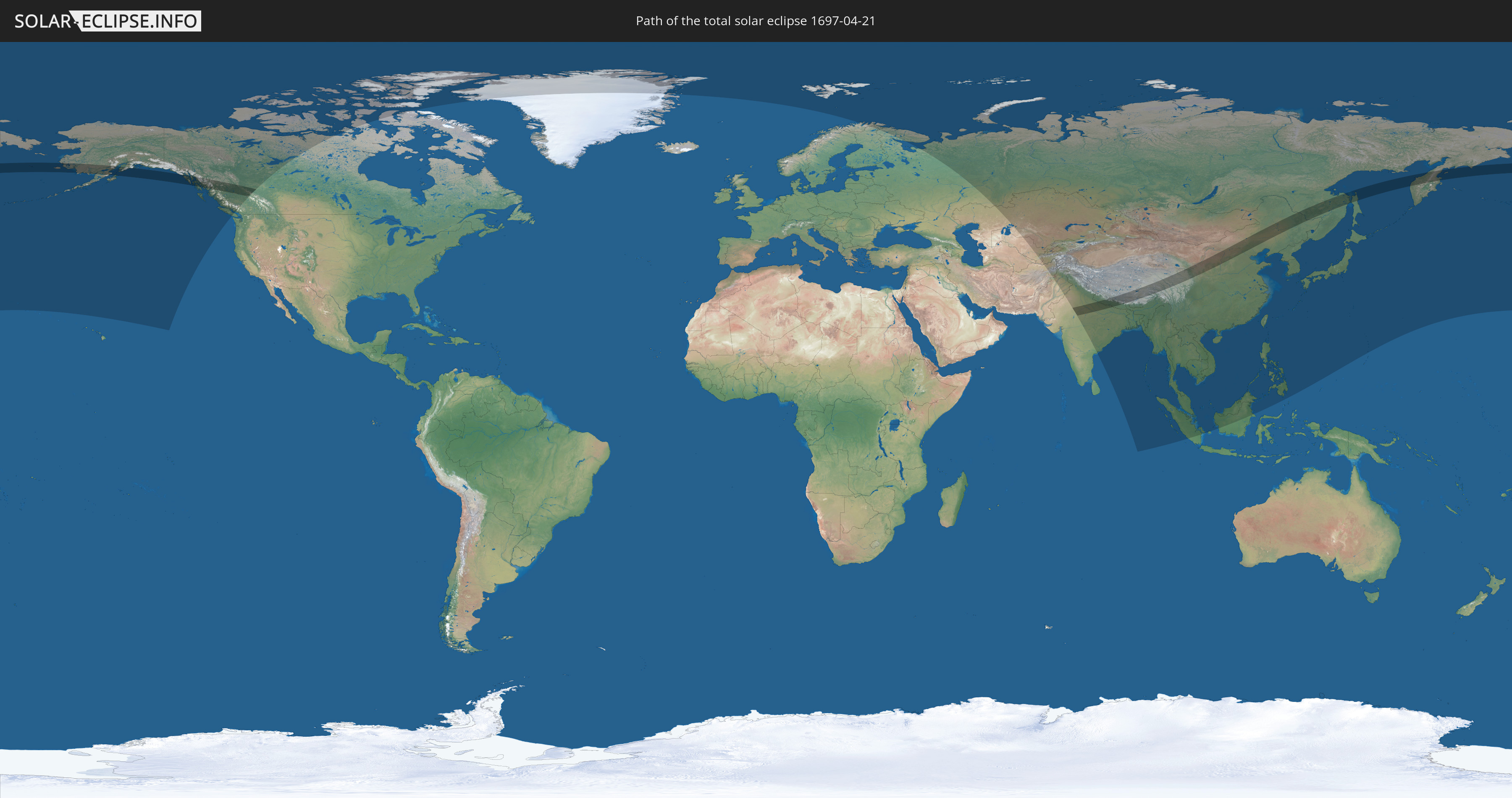
Die Sonnenfinsternis am 04/21/1697 kann man in 37 Ländern als partielle Sonnenfinsternis beobachten.
Der Finsternispfad verläuft durch 6 Länder. Nur in diesen Ländern ist sie als total Sonnenfinsternis zu sehen.
In den folgenden Ländern ist die Sonnenfinsternis total zu sehen
 Russia
 United States
 Canada
 India
India
 China
China
 Nepal
Nepal
In den folgenden Ländern ist die Sonnenfinsternis partiell zu sehen
 Russia
 United States
 United States Minor Outlying Islands
 Canada
 Greenland
 Svalbard and Jan Mayen
 Norway
 Finland
 Kazakhstan
 Uzbekistan
 Afghanistan
 Pakistan
 Tajikistan
 India
India
 Kyrgyzstan
 China
China
 Nepal
Nepal
 Mongolia
 Bangladesh
 Bhutan
 Myanmar
 Indonesia
 Thailand
 Malaysia
 Laos
Laos
 Vietnam
 Cambodia
 Singapore
 Macau
Macau
 Hong Kong
 Brunei
 Taiwan
 Philippines
 Japan
Japan
 North Korea
 South Korea
 Northern Mariana Islands
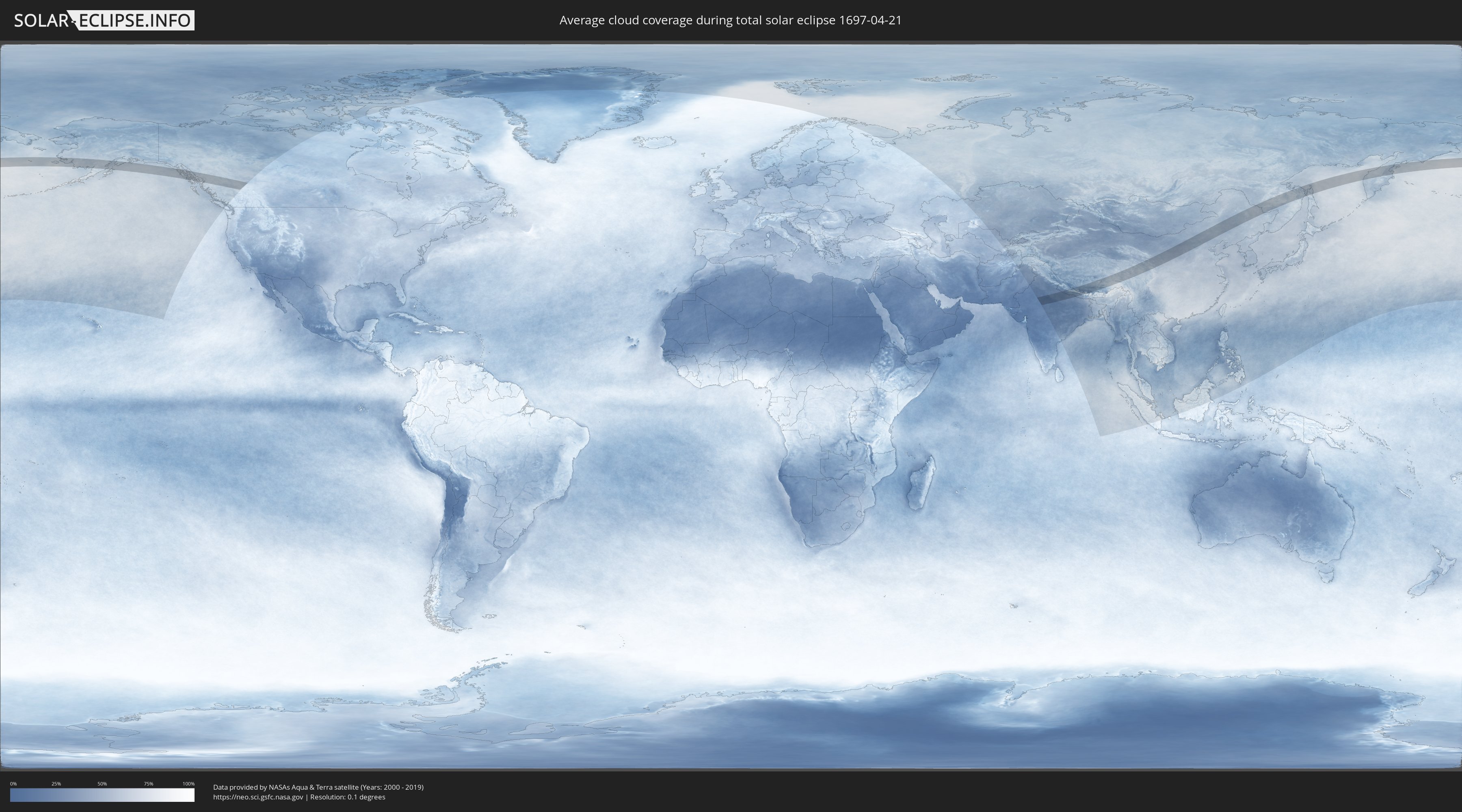
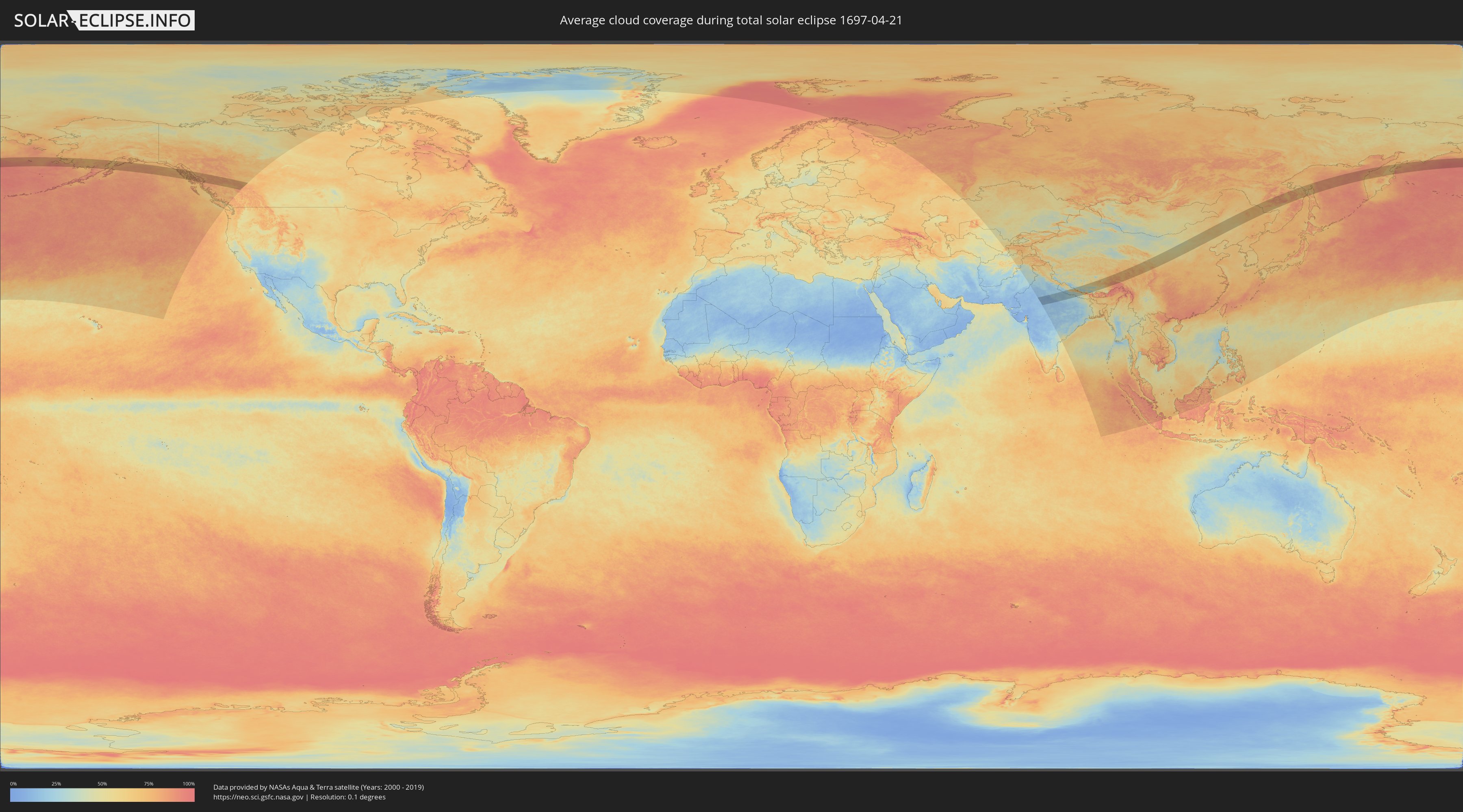
How will be the weather during the total solar eclipse on 04/21/1697?
Where is the best place to see the total solar eclipse of 04/21/1697?
The following maps show the average cloud coverage for the day of the total solar eclipse.
With the help of these maps, it is possible to find the place along the eclipse path, which has the best
chance of a cloudless sky.
Nevertheless, you should consider local circumstances and inform about the weather of your chosen
observation site.
The data is provided by NASAs satellites
AQUA and TERRA.
The cloud maps are averaged over a period of 19 years (2000 - 2019).
Detailed country maps
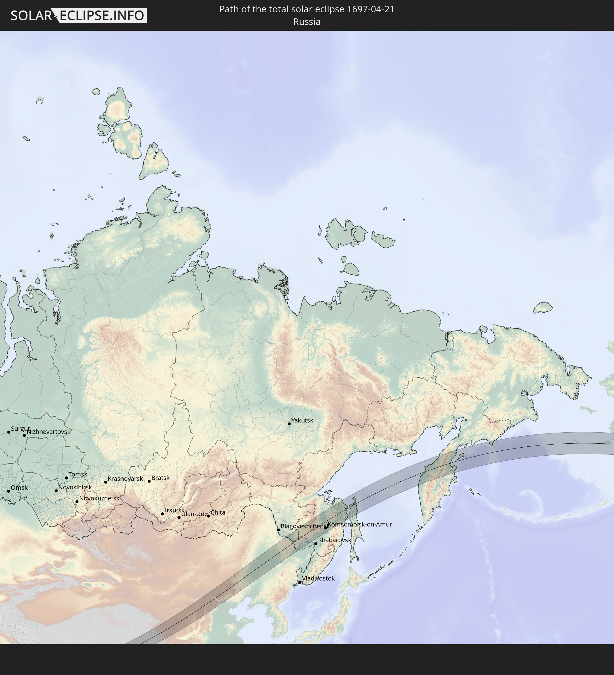
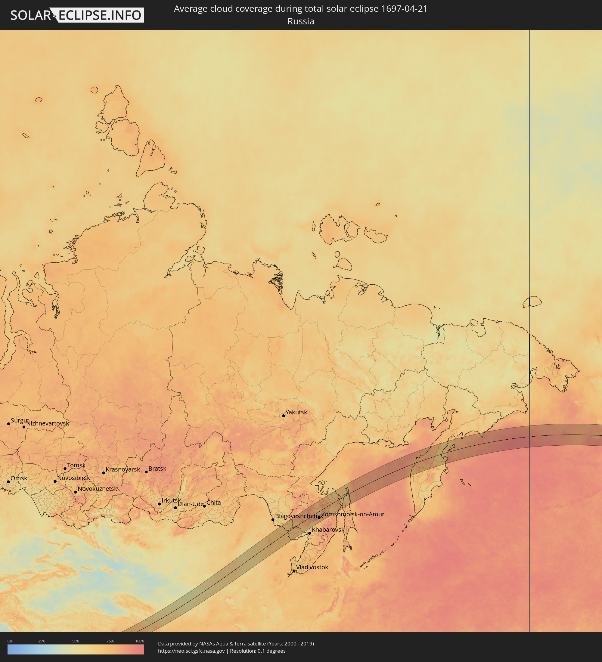 Russia
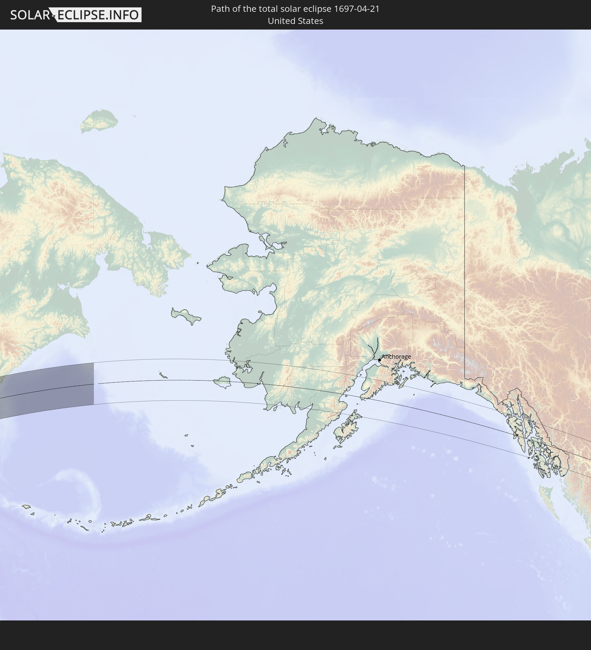
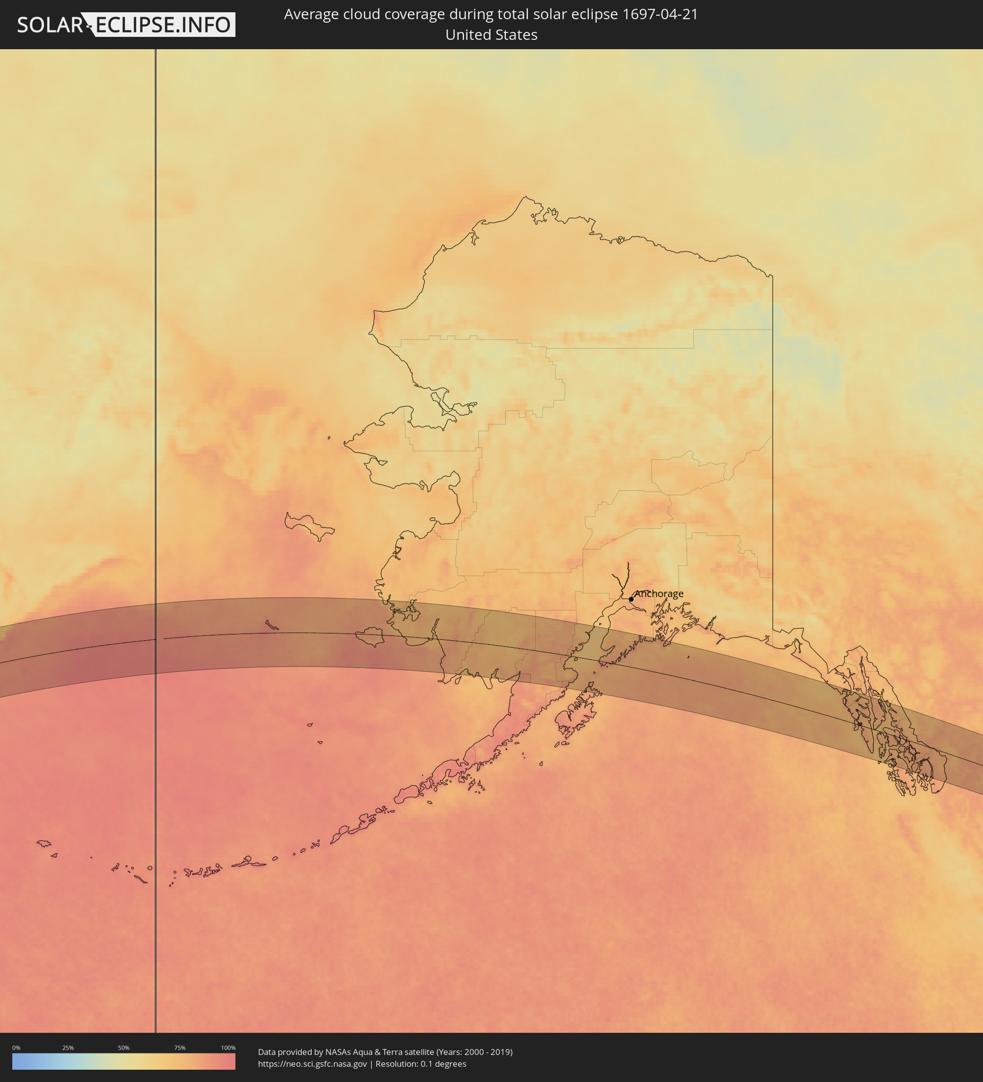 United States
 Canada
 India
India
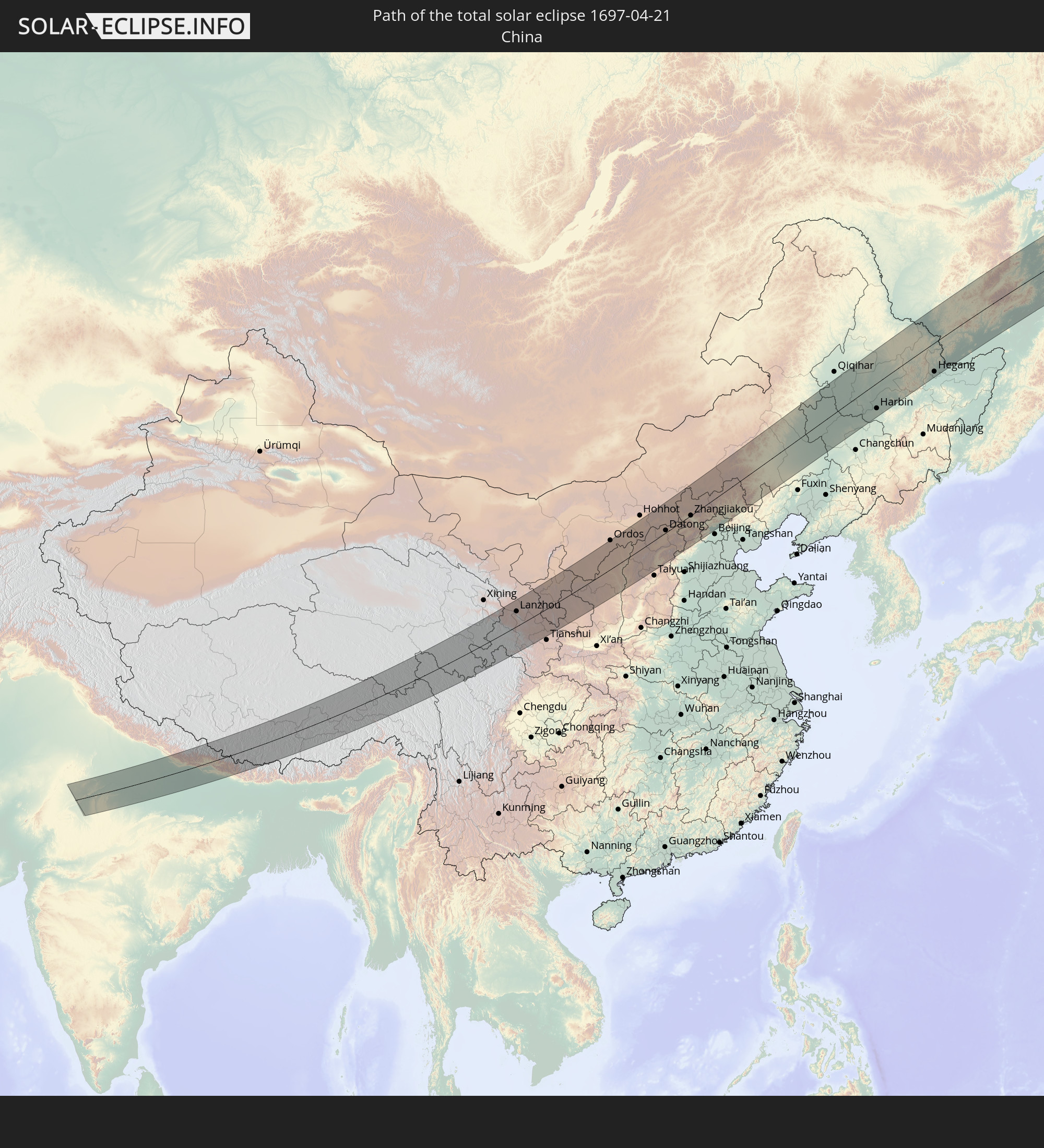
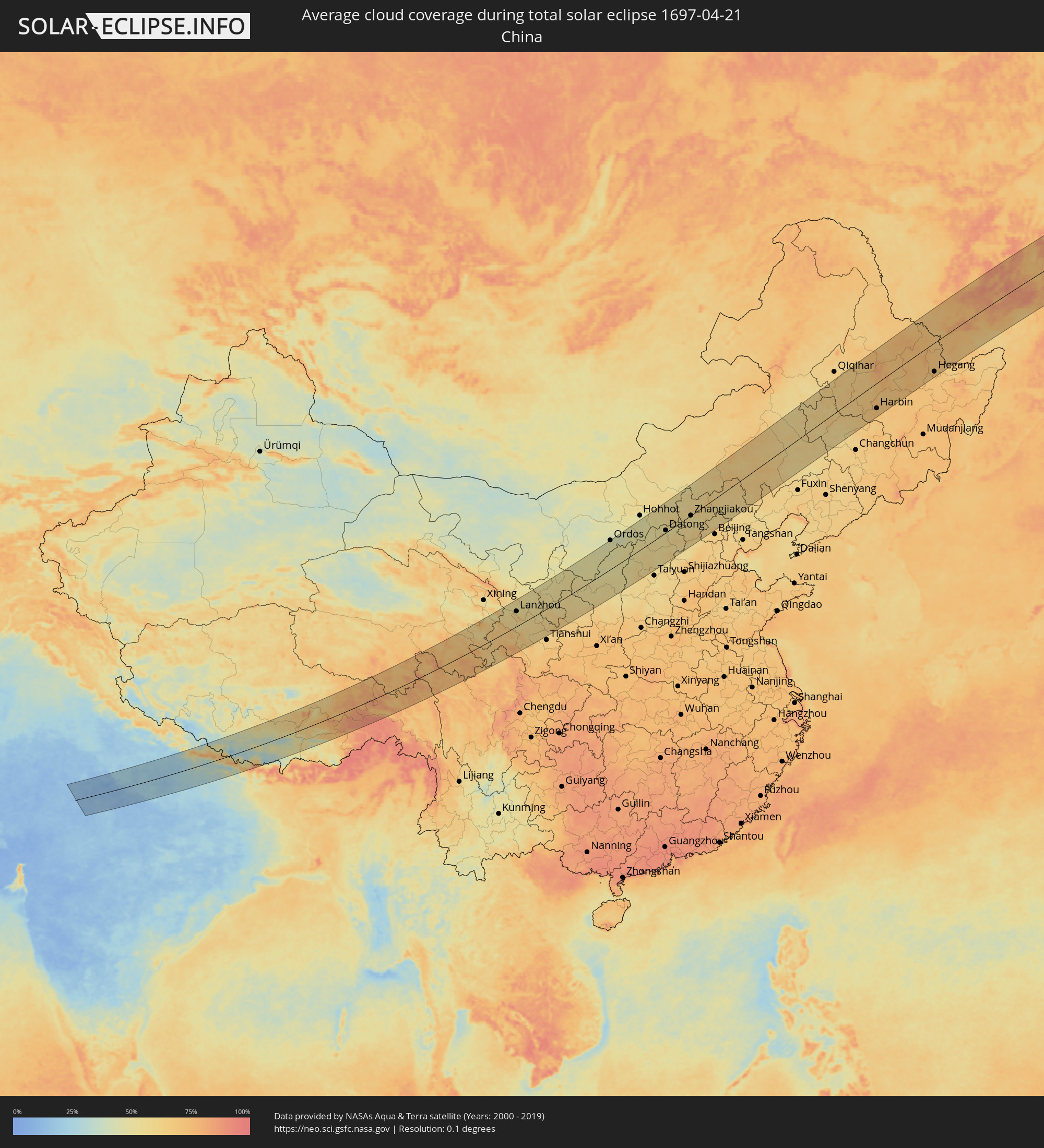 China
China
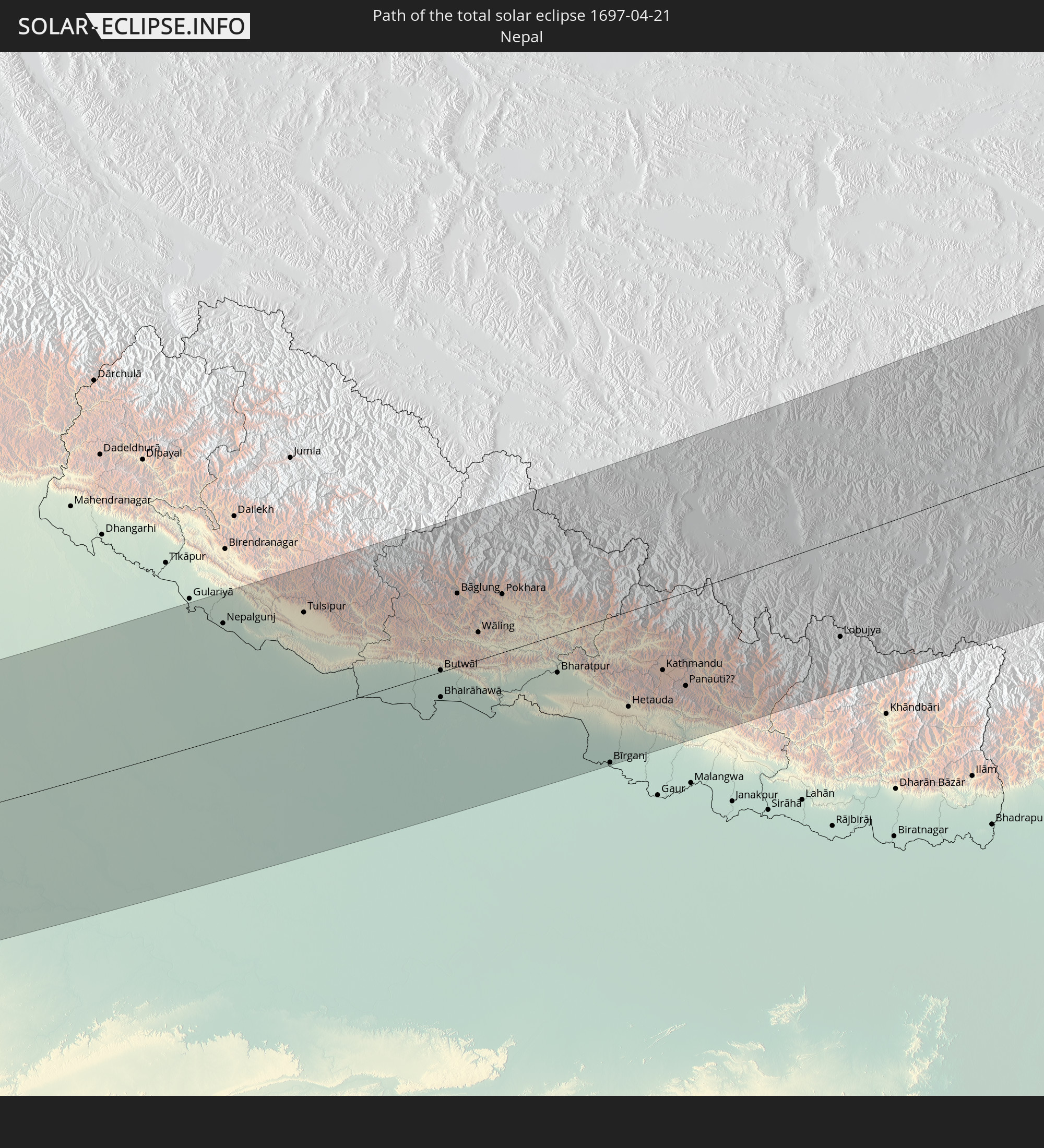
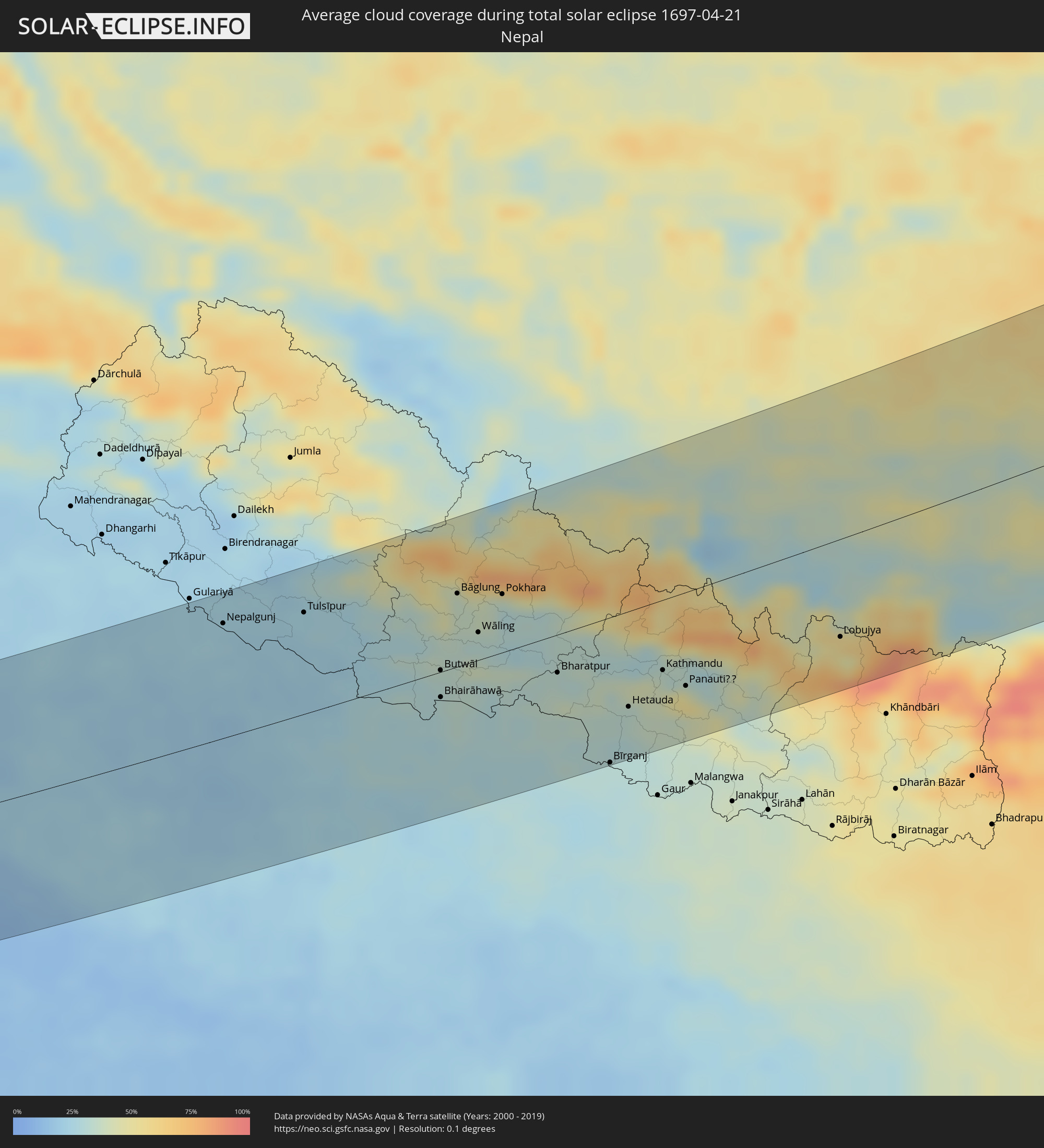 Nepal
Nepal
Cities inside the path of the eclipse
The following table shows all locations with a population of more than 5,000 inside the eclipse path. Cities which have more than 100,000 inhabitants are marked bold. A click at the locations opens a detailed map.
| City | Type | Eclipse duration | Local time of max. eclipse | Distance to central line | Ø Cloud coverage |
|
Bethel, Alaska
|
total | - | 16:53:26 UTC-10:00 | 90 km | 75% |
|
Homer, Alaska
|
total | - | 16:59:04 UTC-10:00 | 43 km | 78% |
|
Sitka, Alaska
|
total | - | 17:05:13 UTC-10:00 | 17 km | 81% |
|
Smithers, British Columbia
|
total | - | 19:07:36 UTC-08:00 | 93 km | 77% |
|
Prince George, British Columbia
|
total | - | 19:07:51 UTC-08:00 | 86 km | 75% |
|
Tonk, Rajasthan
|
total | - | 05:52:51 UTC+05:21 | 39 km | 14% |
|
Sawāi Mādhopur, Rajasthan
|
total | - | 05:52:33 UTC+05:21 | 11 km | 13% |
|
Gangāpur, Rajasthan
|
total | - | 05:52:59 UTC+05:21 | 50 km | 13% |
|
Hindaun, Rajasthan
|
total | - | 05:53:14 UTC+05:21 | 71 km | 13% |
|
Bharatpur, Rajasthan
|
total | - | 05:53:43 UTC+05:21 | 112 km | 14% |
|
Shivpuri, Madhya Pradesh
|
total | - | 05:51:33 UTC+05:21 | 86 km | 17% |
|
Dhaulpur, Rajasthan
|
total | - | 05:53:00 UTC+05:21 | 45 km | 9% |
|
Morena, Madhya Pradesh
|
total | - | 05:52:45 UTC+05:21 | 22 km | 12% |
|
Āgra, Uttar Pradesh
|
total | - | 05:53:35 UTC+05:21 | 95 km | 14% |
|
Gwalior, Madhya Pradesh
|
total | - | 05:52:24 UTC+05:21 | 12 km | 13% |
|
Fīrozābād, Uttar Pradesh
|
total | - | 05:53:28 UTC+05:21 | 82 km | 18% |
|
Datia, Madhya Pradesh
|
total | - | 05:51:40 UTC+05:21 | 79 km | 11% |
|
Jhānsi, Uttar Pradesh
|
total | - | 05:51:24 UTC+05:21 | 105 km | 13% |
|
Shikohābād, Uttar Pradesh
|
total | - | 05:53:23 UTC+05:21 | 72 km | 19% |
|
Bhind, Madhya Pradesh
|
total | - | 05:52:41 UTC+05:21 | 9 km | 13% |
|
Etāwah, Uttar Pradesh
|
total | - | 05:52:54 UTC+05:21 | 25 km | 20% |
|
Mainpuri, Uttar Pradesh
|
total | - | 05:53:27 UTC+05:21 | 74 km | 24% |
|
Orai, Uttar Pradesh
|
total | - | 05:51:52 UTC+05:21 | 70 km | 15% |
|
Farrukhābād, Uttar Pradesh
|
total | - | 05:53:34 UTC+05:21 | 80 km | 20% |
|
Hardoī, Uttar Pradesh
|
total | - | 05:53:29 UTC+05:21 | 66 km | 23% |
|
Kanpur, Uttar Pradesh
|
total | - | 05:52:18 UTC+05:21 | 49 km | 22% |
|
Unnāo, Uttar Pradesh
|
total | - | 05:52:23 UTC+05:21 | 40 km | 23% |
|
Sītāpur, Uttar Pradesh
|
total | - | 05:53:37 UTC+05:21 | 67 km | 22% |
|
Lakhīmpur, Uttar Pradesh
|
total | - | 05:54:06 UTC+05:21 | 104 km | 23% |
|
Lucknow, Uttar Pradesh
|
total | - | 05:52:41 UTC+05:21 | 23 km | 21% |
|
Raebareli, Uttar Pradesh
|
total | - | 05:51:54 UTC+05:21 | 92 km | 22% |
|
Bahraigh, Uttar Pradesh
|
total | - | 05:53:32 UTC+05:21 | 47 km | 21% |
|
Nepalgunj, Mid Western
|
total | - | 06:14:14 UTC+05:41 | 92 km | 23% |
|
Gondā City, Uttar Pradesh
|
total | - | 05:52:56 UTC+05:21 | 19 km | 21% |
|
Sultānpur, Uttar Pradesh
|
total | - | 05:51:50 UTC+05:21 | 116 km | 20% |
|
Fyzābād, Uttar Pradesh
|
total | - | 05:52:28 UTC+05:21 | 60 km | 23% |
|
Tulsīpur, Mid Western
|
total | - | 06:14:17 UTC+05:41 | 81 km | 24% |
|
Besisahar
|
total | - | 06:14:24 UTC+05:41 | 90 km | 25% |
|
Tāndā, Uttar Pradesh
|
total | - | 05:52:08 UTC+05:21 | 99 km | 26% |
|
Bastī, Uttar Pradesh
|
total | - | 05:52:26 UTC+05:21 | 74 km | 25% |
|
Gorakhpur, Uttar Pradesh
|
total | - | 05:52:21 UTC+05:21 | 96 km | 27% |
|
Butwāl, Western Region
|
total | - | 06:13:39 UTC+05:41 | 5 km | 31% |
|
Bhairāhawā, Western Region
|
total | - | 06:13:23 UTC+05:41 | 23 km | 32% |
|
Tānsen, Western Region
|
total | - | 06:13:51 UTC+05:41 | 19 km | 34% |
|
Bāglung, Western Region
|
total | - | 06:14:23 UTC+05:41 | 63 km | 37% |
|
Wāling, Western Region
|
total | - | 06:14:00 UTC+05:41 | 28 km | 31% |
|
Bhattarai Danda, Western Region
|
total | - | 06:13:51 UTC+05:41 | 8 km | 31% |
|
Pokhara, Western Region
|
total | - | 06:14:21 UTC+05:41 | 47 km | 38% |
|
Bagaha, Bihar
|
total | - | 05:52:44 UTC+05:21 | 83 km | 28% |
|
Bharatpur, Central Region
|
total | - | 06:13:34 UTC+05:41 | 34 km | 33% |
|
Bīrganj, Central Region
|
total | - | 06:12:41 UTC+05:41 | 115 km | 30% |
|
Hetauda, Central Region
|
total | - | 06:13:13 UTC+05:41 | 78 km | 32% |
|
Kirtipur, Central Region
|
total | - | 06:13:33 UTC+05:41 | 57 km | 38% |
|
Pātan, Central Region
|
total | - | 06:13:33 UTC+05:41 | 59 km | 38% |
|
Kathmandu, Central Region
|
total | - | 06:13:35 UTC+05:41 | 57 km | 38% |
|
Hari Bdr Tamang House, Central Region
|
total | - | 06:13:29 UTC+05:41 | 72 km | 49% |
|
kankrabari Dovan, Central Region
|
total | - | 06:13:29 UTC+05:41 | 72 km | 49% |
|
Panauti̇̄, Central Region
|
total | - | 06:13:25 UTC+05:41 | 77 km | 49% |
|
Banepā, Central Region
|
total | - | 06:13:29 UTC+05:41 | 72 km | 49% |
|
Lobujya, Eastern Region
|
total | - | 06:13:55 UTC+05:41 | 76 km | 54% |
|
Lhasa, Tibet Autonomous Region
|
total | - | 08:35:23 UTC+08:00 | 45 km | 52% |
|
Linxia Chengguanzhen, Gansu
|
total | - | 08:48:58 UTC+08:00 | 59 km | 57% |
|
Lanzhou, Gansu
|
total | - | 08:50:05 UTC+08:00 | 79 km | 56% |
|
Baiyin, Gansu
|
total | - | 08:51:06 UTC+08:00 | 106 km | 54% |
|
Pingliang, Gansu
|
total | - | 08:51:01 UTC+08:00 | 106 km | 63% |
|
Yulin, Shaanxi
|
total | - | 08:57:57 UTC+08:00 | 22 km | 48% |
|
Ordos, Inner Mongolia
|
total | - | 09:00:15 UTC+08:00 | 133 km | 46% |
|
Xinzhou, Shanxi
|
total | - | 09:00:39 UTC+08:00 | 119 km | 55% |
|
Jining, Inner Mongolia
|
total | - | 09:05:31 UTC+08:00 | 104 km | 56% |
|
Datong, Shanxi
|
total | - | 09:04:04 UTC+08:00 | 18 km | 53% |
|
Zhangjiakou, Hebei
|
total | - | 09:06:47 UTC+08:00 | 1 km | 56% |
|
Zhangjiakou Shi Xuanhua Qu, Hebei
|
total | - | 09:06:35 UTC+08:00 | 27 km | 54% |
|
Changping, Beijing
|
total | - | 09:07:04 UTC+08:00 | 120 km | 65% |
|
Chifeng, Inner Mongolia
|
total | - | 09:13:26 UTC+08:00 | 63 km | 65% |
|
Tongliao, Inner Mongolia
|
total | - | 09:19:23 UTC+08:00 | 96 km | 61% |
|
Guangming, Jilin
|
total | - | 09:22:49 UTC+08:00 | 37 km | 60% |
|
Baicheng, Jilin
|
total | - | 09:23:18 UTC+08:00 | 64 km | 62% |
|
Dalai, Jilin
|
total | - | 09:24:52 UTC+08:00 | 18 km | 61% |
|
Fuyu, Jilin
|
total | - | 09:24:59 UTC+08:00 | 73 km | 63% |
|
Fendou, Heilongjiang
|
total | - | 09:27:21 UTC+08:00 | 60 km | 68% |
|
Honggang, Heilongjiang
|
total | - | 09:27:00 UTC+08:00 | 41 km | 65% |
|
Longfeng, Heilongjiang
|
total | - | 09:27:28 UTC+08:00 | 39 km | 69% |
|
Anda, Heilongjiang
|
total | - | 09:27:31 UTC+08:00 | 18 km | 65% |
|
Zhaodong, Heilongjiang
|
total | - | 09:27:49 UTC+08:00 | 42 km | 67% |
|
Shuangcheng, Heilongjiang
|
total | - | 09:27:04 UTC+08:00 | 121 km | 68% |
|
Hulan, Heilongjiang
|
total | - | 09:28:27 UTC+08:00 | 77 km | 74% |
|
Bei’an, Heilongjiang
|
total | - | 09:31:57 UTC+08:00 | 130 km | 72% |
|
Harbin, Heilongjiang
|
total | - | 09:28:09 UTC+08:00 | 101 km | 71% |
|
Hailun, Heilongjiang
|
total | - | 09:31:09 UTC+08:00 | 46 km | 76% |
|
Suihua, Heilongjiang
|
total | - | 09:29:57 UTC+08:00 | 41 km | 70% |
|
Tieli, Heilongjiang
|
total | - | 09:31:48 UTC+08:00 | 52 km | 68% |
|
Yichun, Heilongjiang
|
total | - | 09:33:57 UTC+08:00 | 28 km | 71% |
|
Lianhe, Heilongjiang
|
total | - | 09:33:36 UTC+08:00 | 89 km | 68% |
|
Novobureyskiy, Amur
|
total | - | 10:17:09 UTC+08:38 | 130 km | 66% |
|
Arkhara, Amur
|
total | - | 10:16:54 UTC+08:38 | 89 km | 68% |
|
Hegang, Heilongjiang
|
total | - | 09:35:16 UTC+08:00 | 113 km | 71% |
|
Amurzet, Jewish Autonomous Oblast
|
total | - | 10:24:19 UTC+08:47 | 116 km | 70% |
|
Birobidzhan, Jewish Autonomous Oblast
|
total | - | 10:28:16 UTC+08:47 | 90 km | 66% |
|
Chegdomyn, Khabarovsk Krai
|
total | - | 10:31:26 UTC+08:47 | 125 km | 73% |
|
Berëzovyy, Khabarovsk Krai
|
total | - | 10:35:30 UTC+08:47 | 76 km | 78% |
|
Solnechnyy, Khabarovsk Krai
|
total | - | 10:35:41 UTC+08:47 | 55 km | 88% |
|
Amursk, Khabarovsk Krai
|
total | - | 10:35:27 UTC+08:47 | 107 km | 77% |
|
Khurba, Khabarovsk Krai
|
total | - | 10:35:39 UTC+08:47 | 92 km | 75% |
|
Komsomolsk-on-Amur, Khabarovsk Krai
|
total | - | 10:35:59 UTC+08:47 | 82 km | 78% |
|
Solnechnyy, Khabarovsk Krai
|
total | - | 10:36:03 UTC+08:47 | 80 km | 78% |
|
Nikolayevsk-on-Amure, Khabarovsk Krai
|
total | - | 10:43:42 UTC+08:47 | 34 km | 78% |
|
Okha, Sakhalin
|
total | - | 12:14:24 UTC+10:14 | 4 km | 71% |