Total solar eclipse of 08/12/2045
| Day of week: | Saturday |
| Maximum duration of eclipse: | 06m06s |
| Maximum width of eclipse path: | 256 km |
| Saros cycle: | 136 |
| Coverage: | 100% |
| Magnitude: | 1.0774 |
| Gamma: | 0.2116 |
Wo kann man die Sonnenfinsternis vom 08/12/2045 sehen?
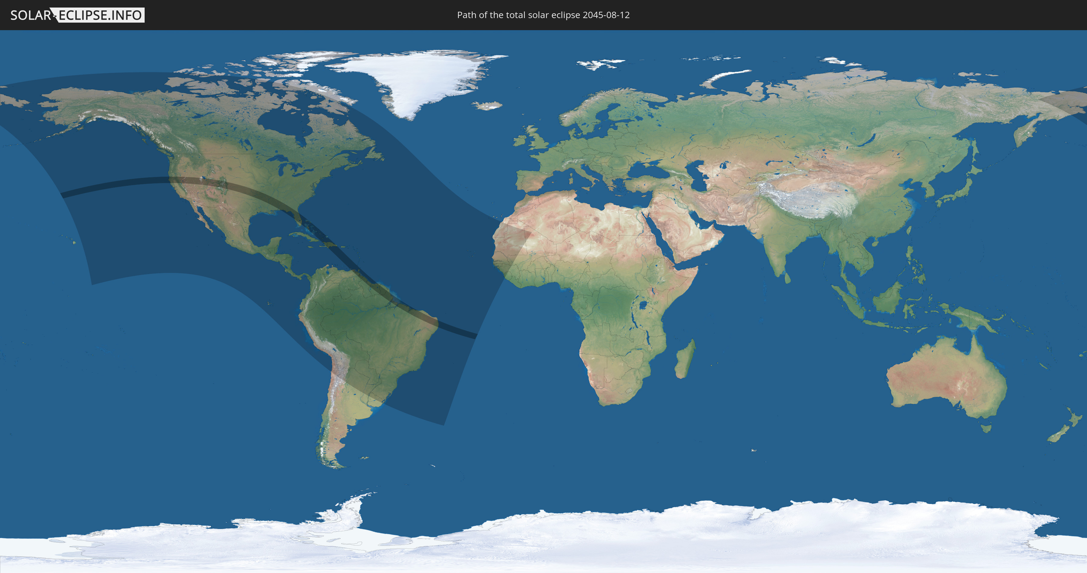
Die Sonnenfinsternis am 08/12/2045 kann man in 62 Ländern als partielle Sonnenfinsternis beobachten.
Der Finsternispfad verläuft durch 11 Länder. Nur in diesen Ländern ist sie als total Sonnenfinsternis zu sehen.
In den folgenden Ländern ist die Sonnenfinsternis total zu sehen
 United States
 The Bahamas
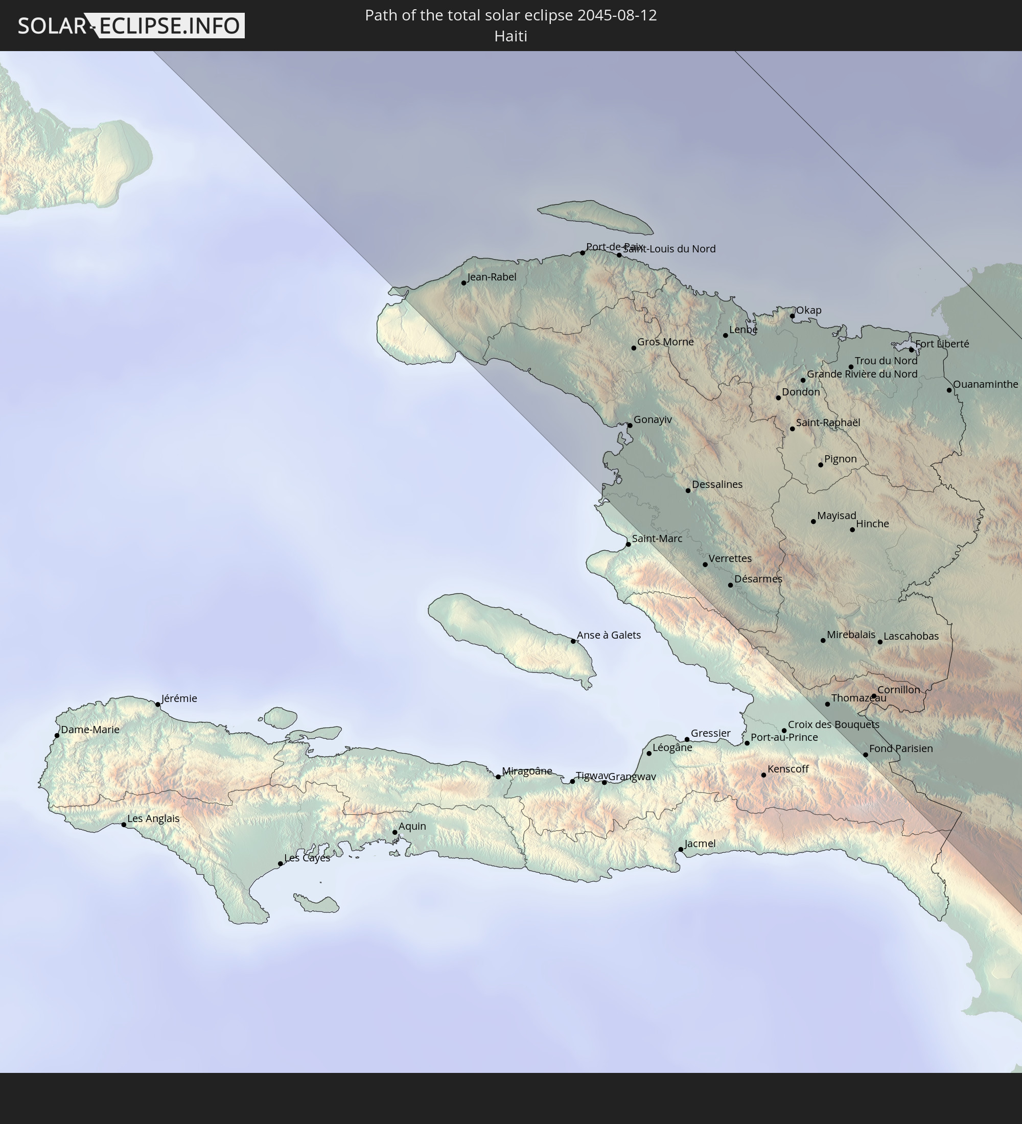 Haiti
Haiti
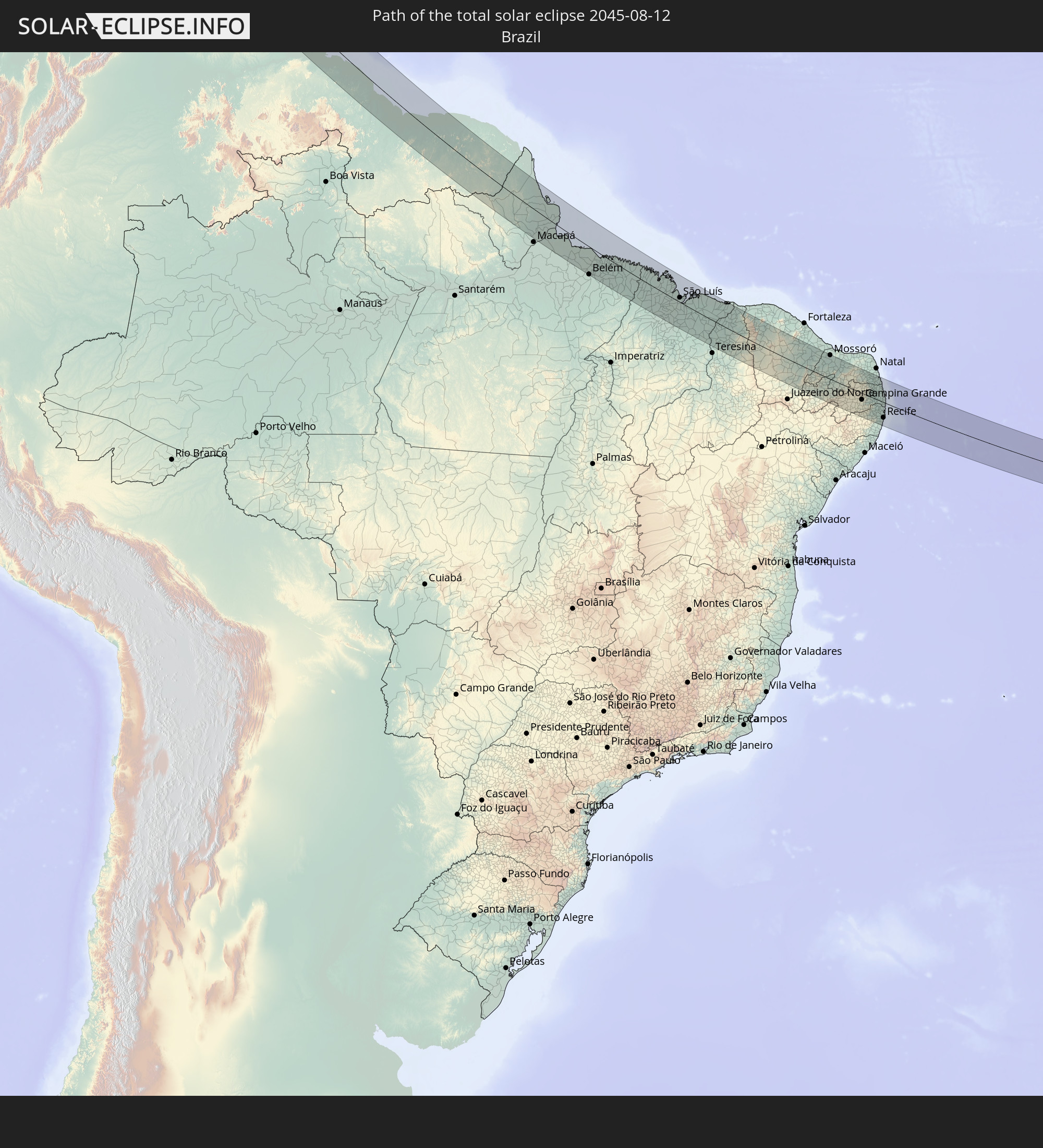 Brazil
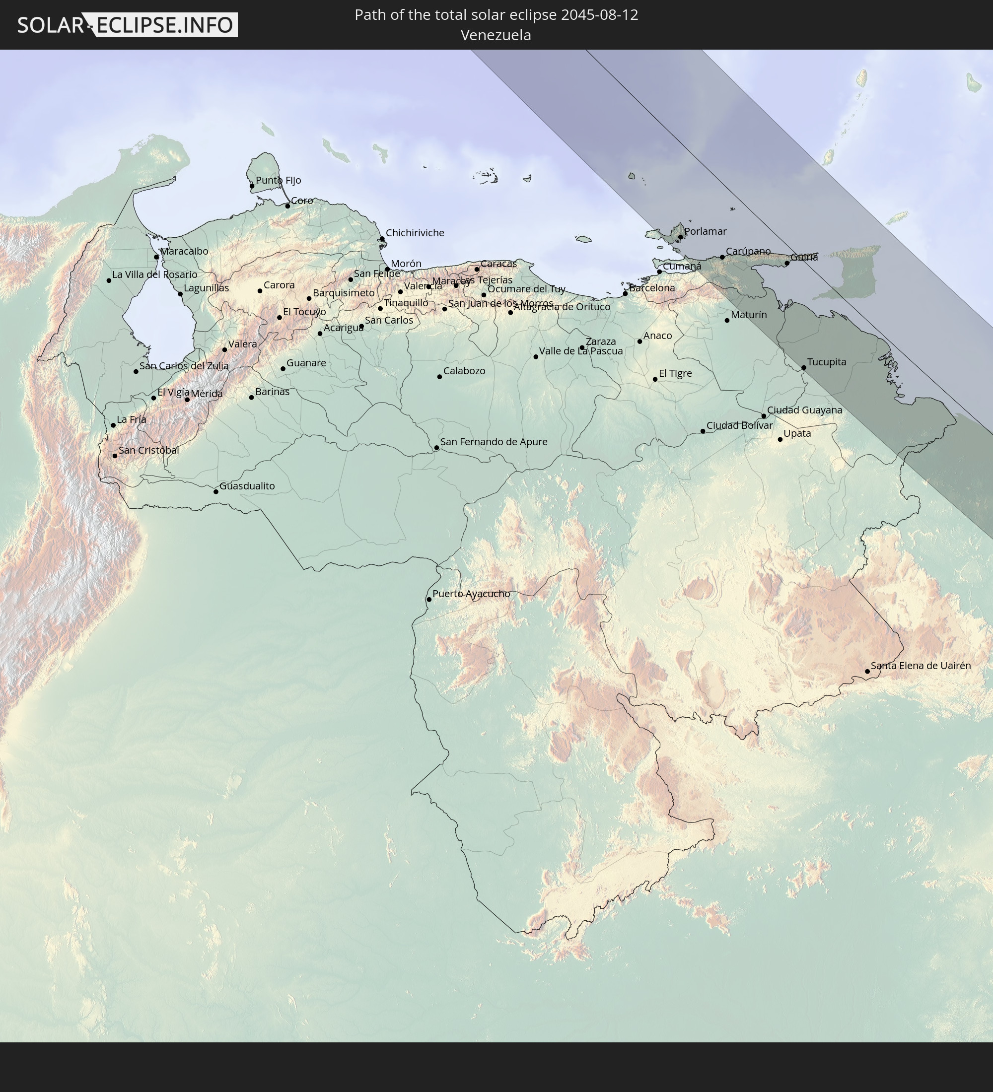 Venezuela
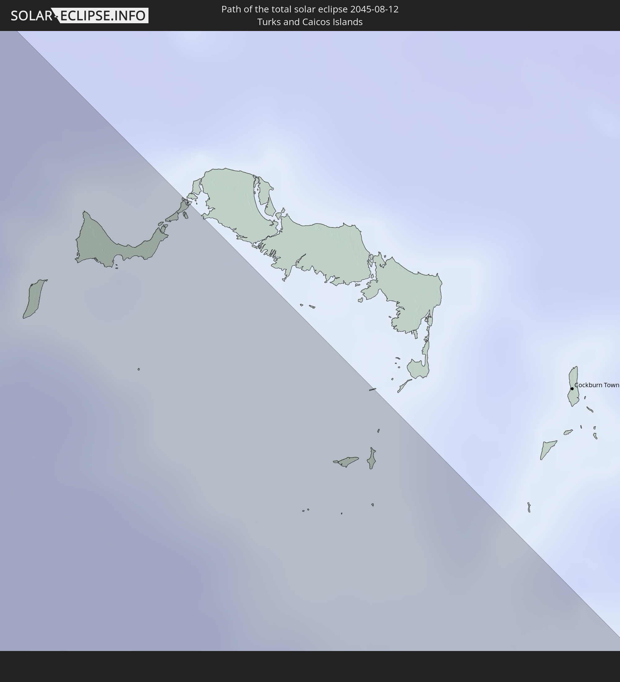 Turks and Caicos Islands
 Dominican Republic
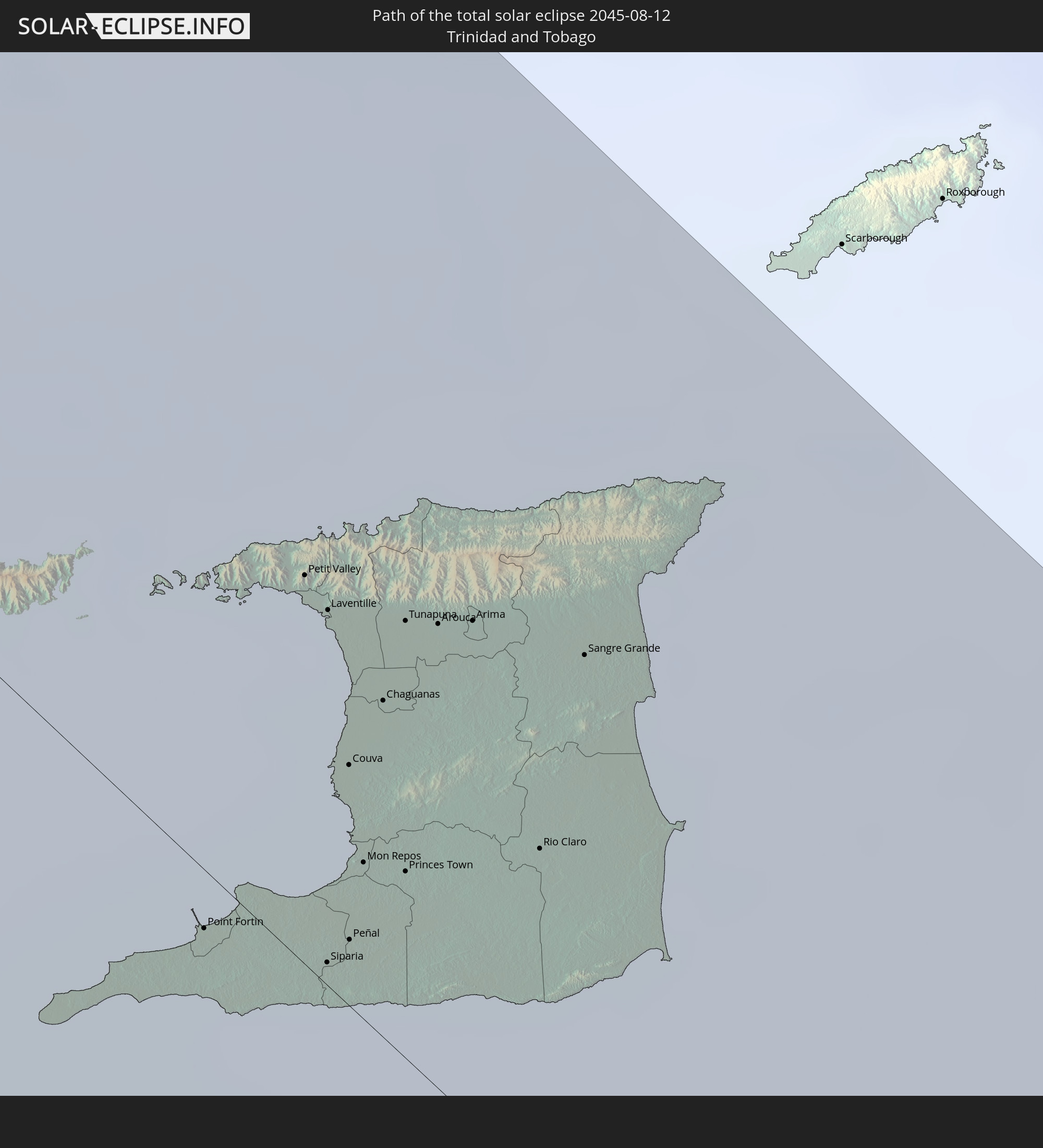 Trinidad and Tobago
 Guyana
 Suriname
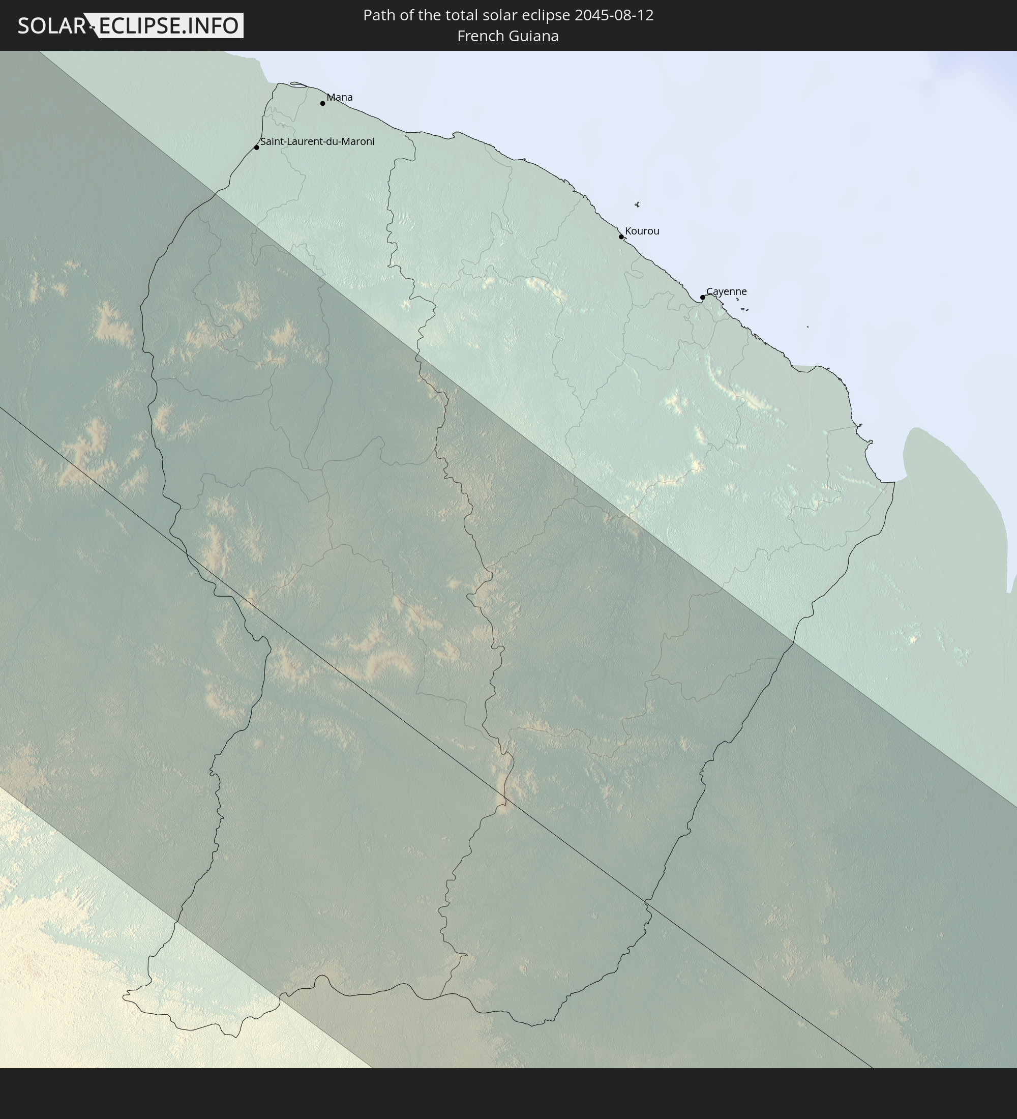 French Guiana
In den folgenden Ländern ist die Sonnenfinsternis partiell zu sehen
 Russia
 United States
 United States Minor Outlying Islands
 Canada
 Mexico
 Chile
Chile
 Greenland
 Guatemala
 Ecuador
 El Salvador
 Honduras
 Belize
 Nicaragua
 Costa Rica
 Cuba
Cuba
 Panama
 Colombia
 Cayman Islands
 Peru
Peru
 The Bahamas
 Jamaica
 Haiti
Haiti
 Brazil
 Argentina
 Venezuela
 Turks and Caicos Islands
 Dominican Republic
 Aruba
Aruba
 Bolivia
 Puerto Rico
 United States Virgin Islands
 Bermuda
 British Virgin Islands
 Anguilla
 Collectivity of Saint Martin
 Saint Barthélemy
 Saint Kitts and Nevis
 Paraguay
 Antigua and Barbuda
 Montserrat
 Trinidad and Tobago
 Guadeloupe
 Grenada
 Dominica
 Saint Vincent and the Grenadines
 Guyana
 Martinique
 Saint Lucia
 Barbados
 Uruguay
 Suriname
 Saint Pierre and Miquelon
 French Guiana
 Cabo Verde
 Spain
Spain
 Senegal
 Mauritania
 The Gambia
 Guinea-Bissau
 Guinea
 Sierra Leone
 Mali
Mali
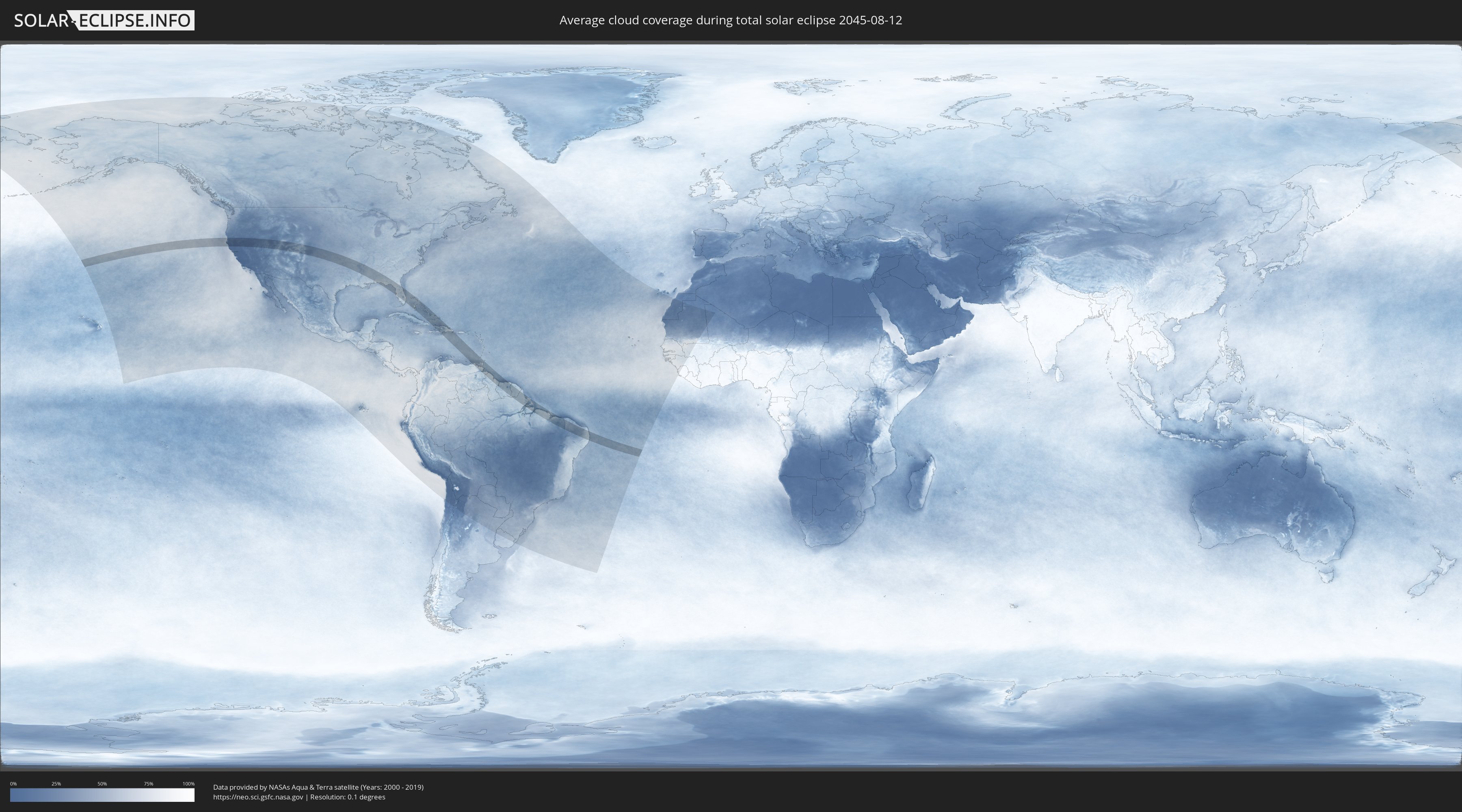
How will be the weather during the total solar eclipse on 08/12/2045?
Where is the best place to see the total solar eclipse of 08/12/2045?
The following maps show the average cloud coverage for the day of the total solar eclipse.
With the help of these maps, it is possible to find the place along the eclipse path, which has the best
chance of a cloudless sky.
Nevertheless, you should consider local circumstances and inform about the weather of your chosen
observation site.
The data is provided by NASAs satellites
AQUA and TERRA.
The cloud maps are averaged over a period of 19 years (2000 - 2019).

Detailed country maps
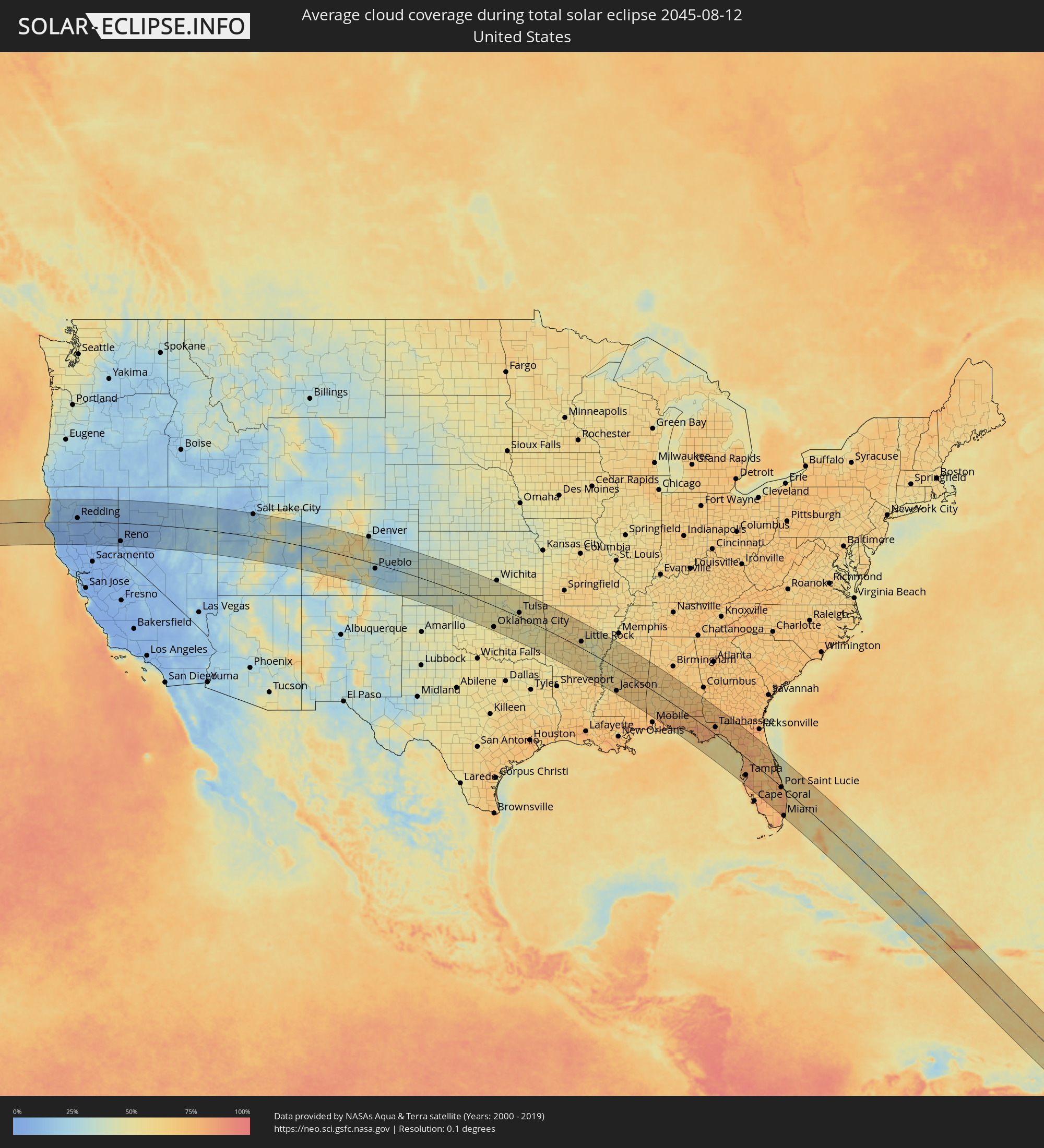 United States
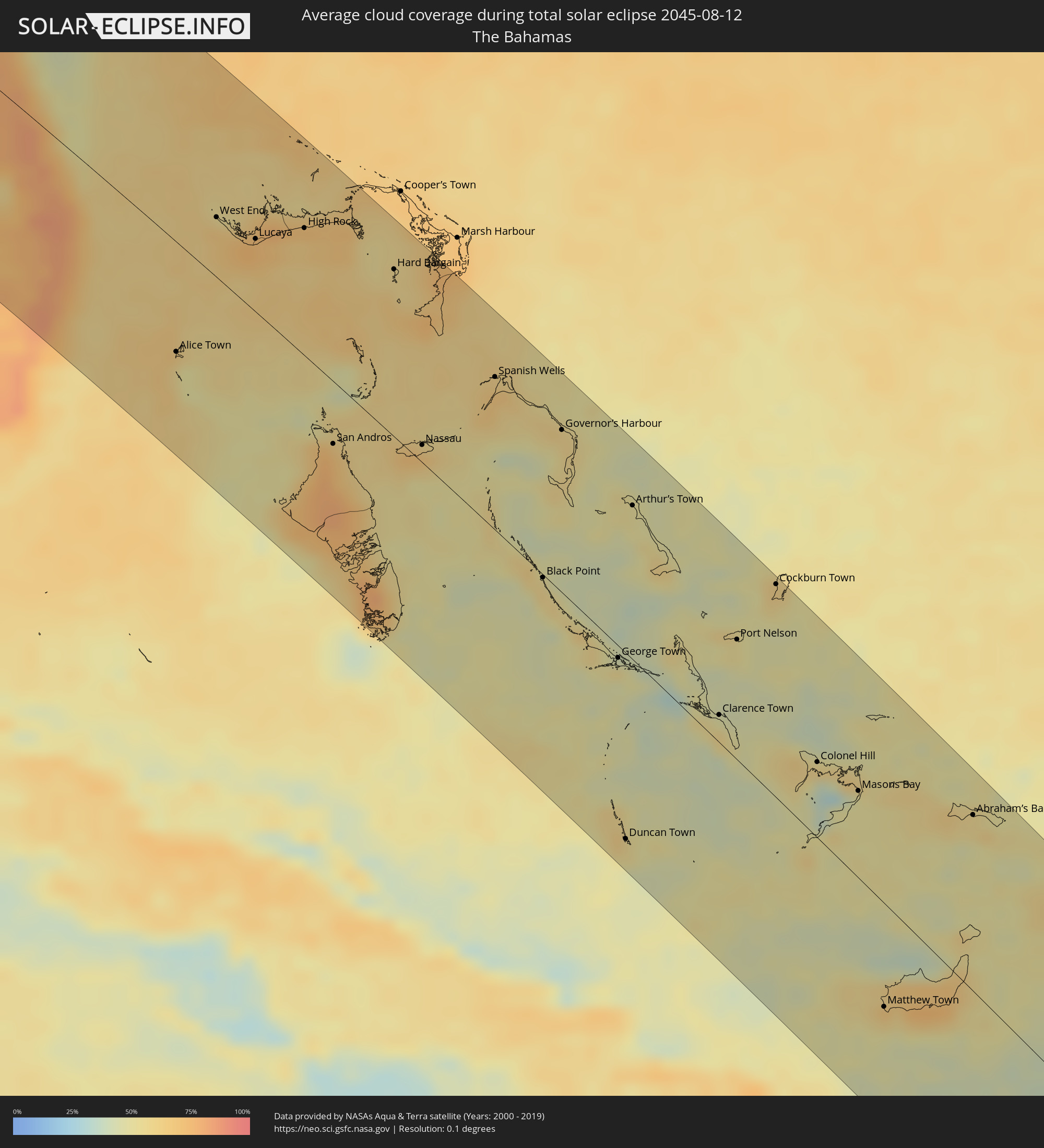 The Bahamas
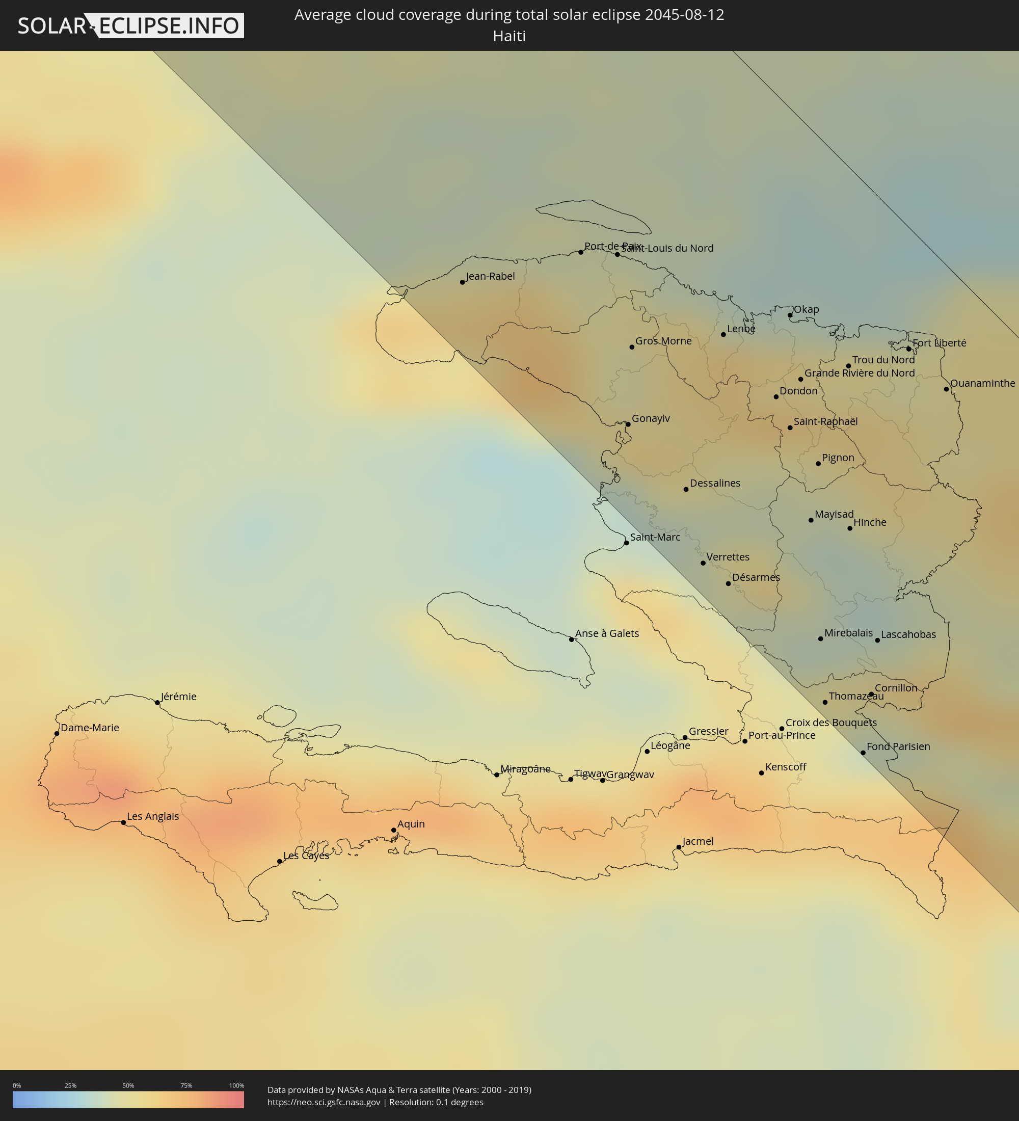 Haiti
Haiti
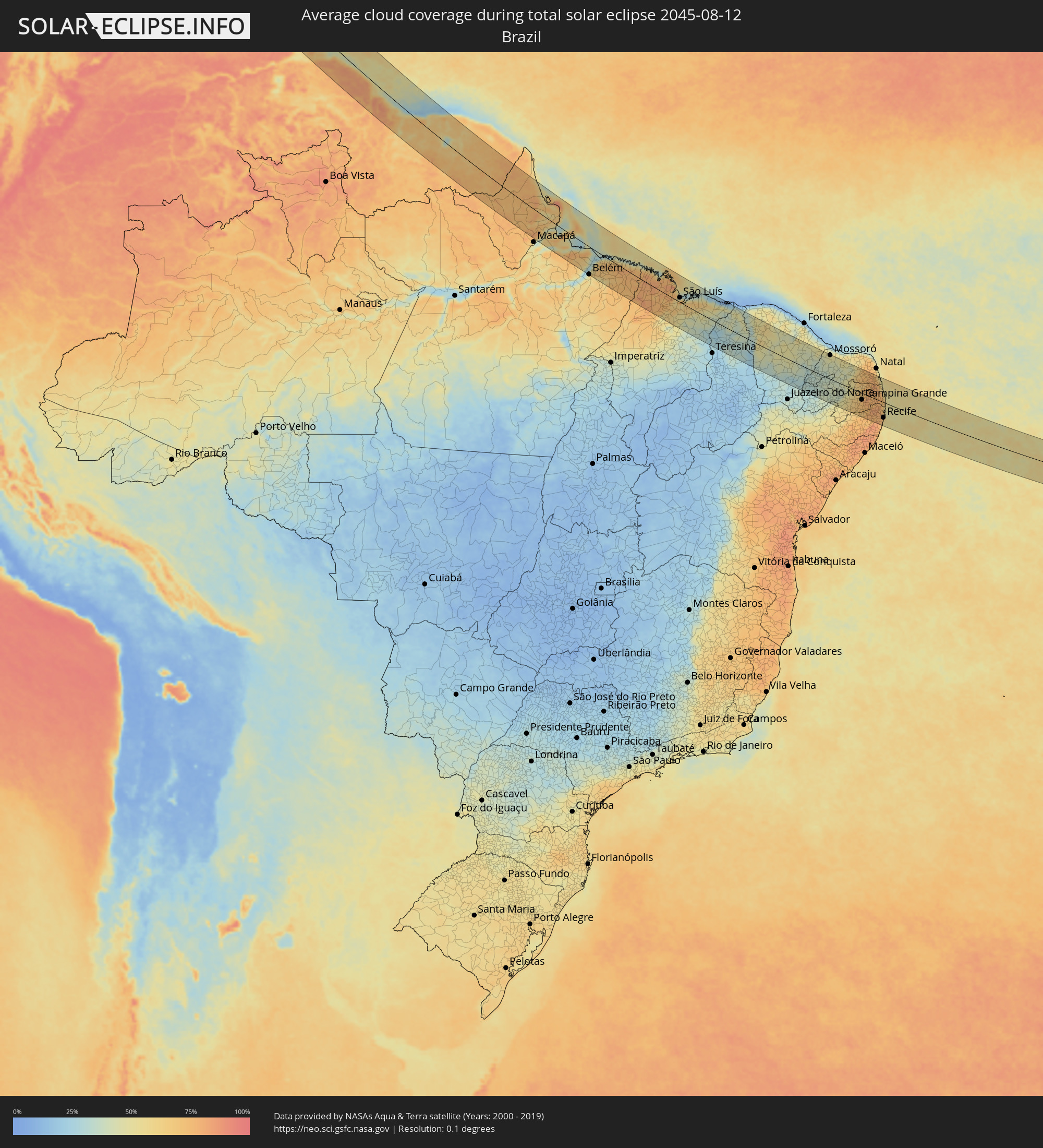 Brazil
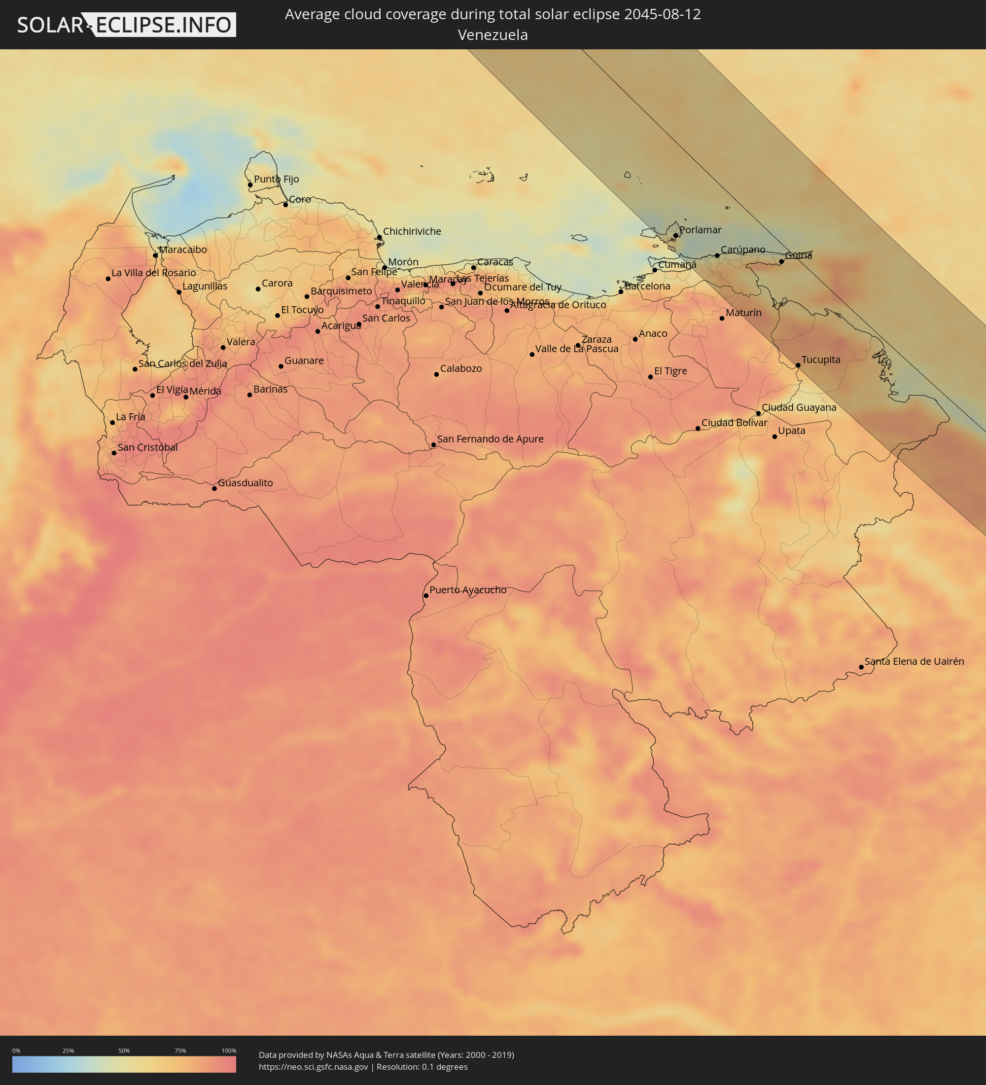 Venezuela
 Turks and Caicos Islands
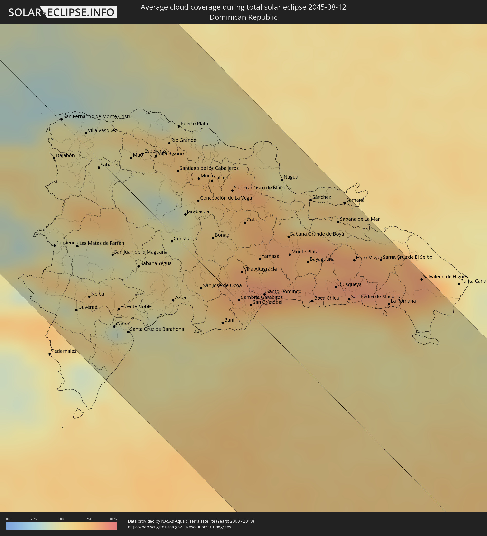 Dominican Republic
 Trinidad and Tobago
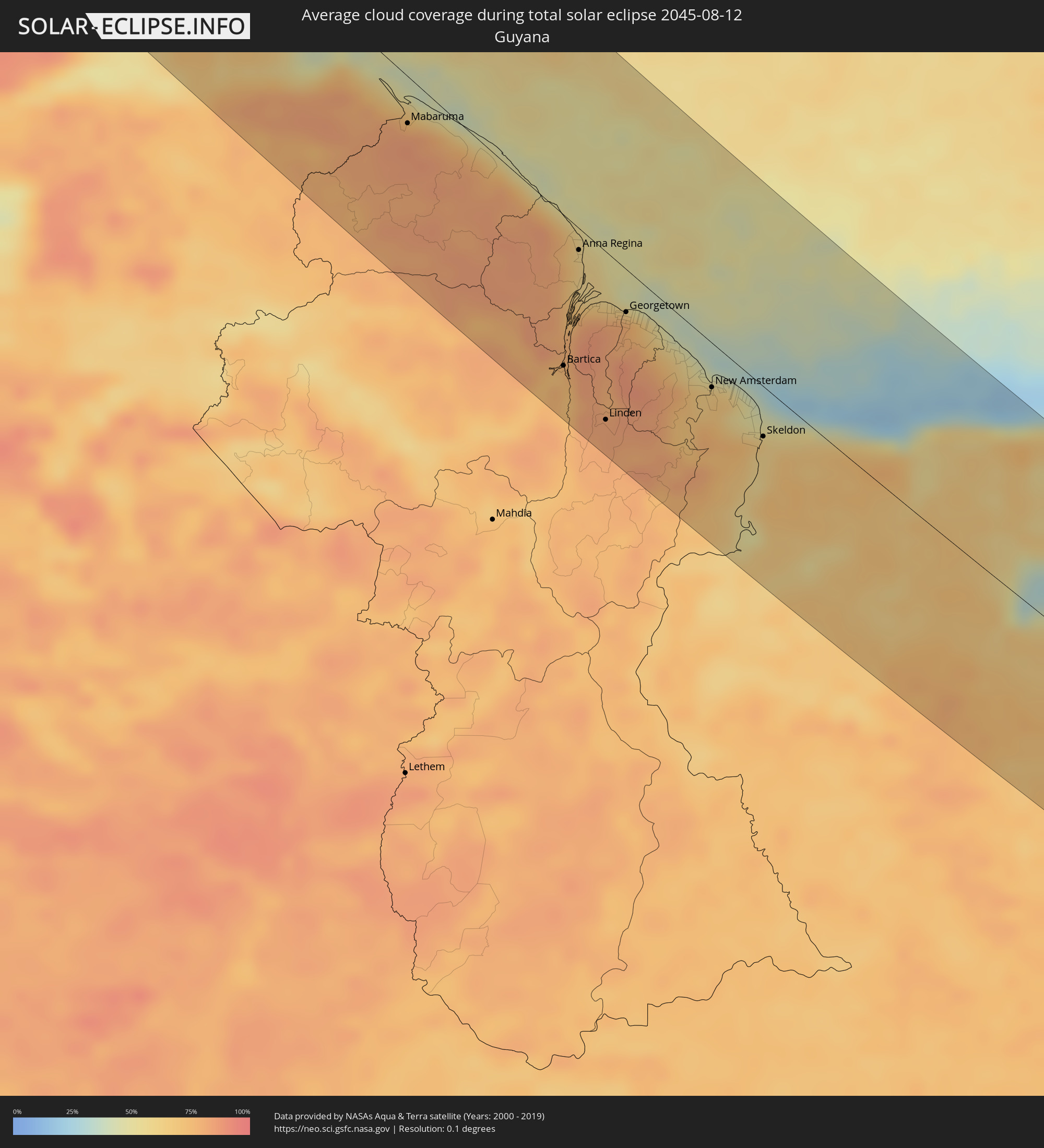 Guyana
 Suriname
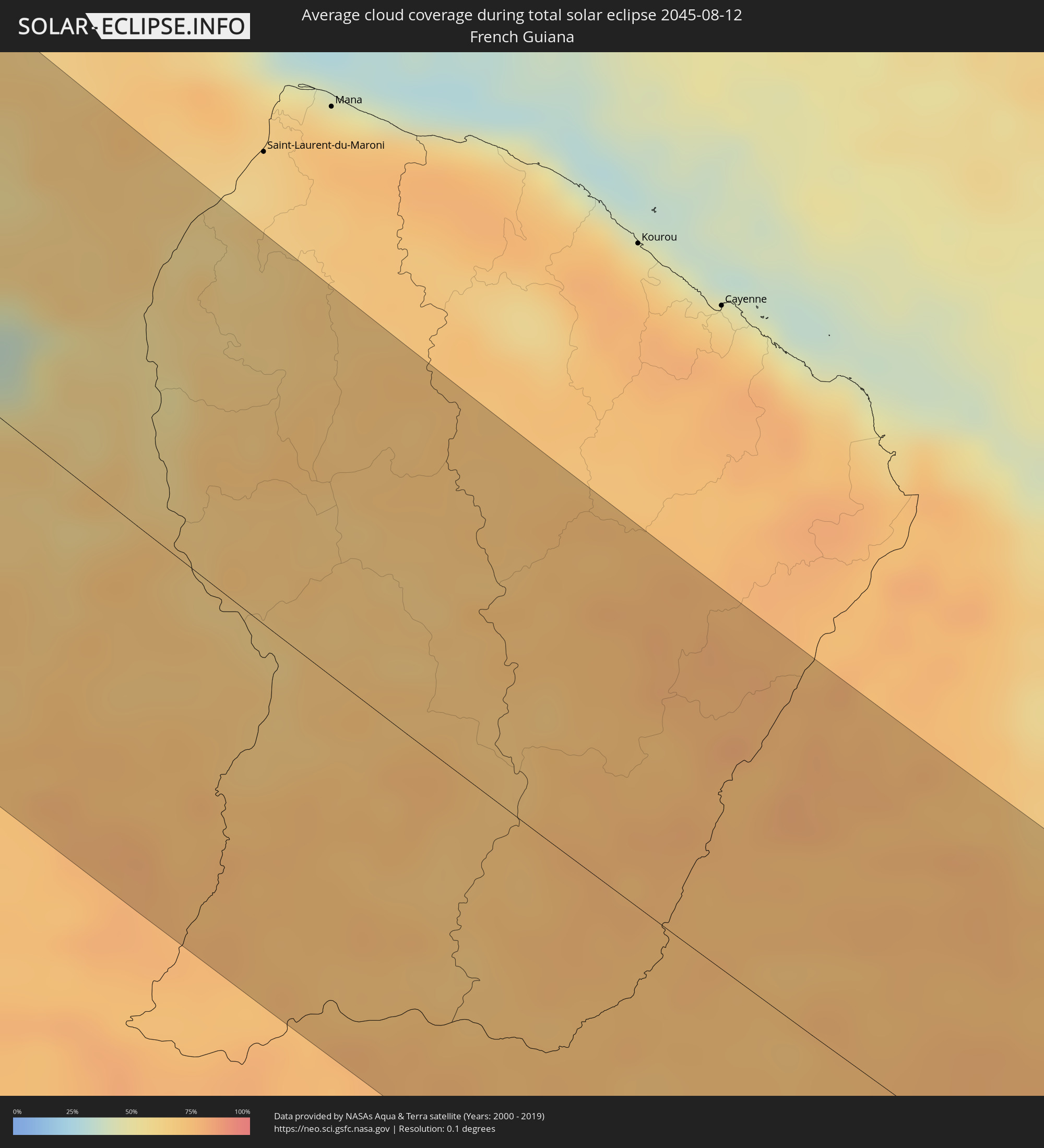 French Guiana
Cities inside the path of the eclipse
The following table shows all locations with a population of more than 5,000 inside the eclipse path. Cities which have more than 100,000 inhabitants are marked bold. A click at the locations opens a detailed map.
| City | Type | Eclipse duration | Local time of max. eclipse | Distance to central line | Ø Cloud coverage |
|
Reno, Nevada
|
total | - | 08:20:01 UTC-08:00 | 92 km | 10% |
|
West Jordan, Utah
|
total | - | 09:29:18 UTC-07:00 | 96 km | 18% |
|
Salt Lake City, Utah
|
total | - | 09:29:22 UTC-07:00 | 113 km | 19% |
|
Provo, Utah
|
total | - | 09:29:38 UTC-07:00 | 58 km | 19% |
|
Lakewood, Colorado
|
total | - | 09:38:39 UTC-07:00 | 120 km | 37% |
|
Colorado Springs, Colorado
|
total | - | 09:39:15 UTC-07:00 | 33 km | 43% |
|
Pueblo, Colorado
|
total | - | 09:39:45 UTC-07:00 | 24 km | 23% |
|
Oklahoma City, Oklahoma
|
total | - | 10:52:50 UTC-06:00 | 105 km | 55% |
|
Tulsa, Oklahoma
|
total | - | 10:54:59 UTC-06:00 | 21 km | 51% |
|
Little Rock, Arkansas
|
total | - | 11:02:47 UTC-06:00 | 31 km | 58% |
|
Jackson, Mississippi
|
total | - | 11:09:21 UTC-06:00 | 109 km | 68% |
|
Montgomery, Alabama
|
total | - | 11:16:33 UTC-06:00 | 95 km | 71% |
|
Tallahassee, Florida
|
total | - | 12:23:01 UTC-05:00 | 32 km | 82% |
|
Clearwater, Florida
|
total | - | 12:29:39 UTC-05:00 | 98 km | 74% |
|
St. Petersburg, Florida
|
total | - | 12:30:12 UTC-05:00 | 108 km | 71% |
|
Tampa, Florida
|
total | - | 12:30:20 UTC-05:00 | 79 km | 68% |
|
Gainesville, Florida
|
total | - | 12:27:53 UTC-05:00 | 78 km | 80% |
|
Orlando, Florida
|
total | - | 12:31:25 UTC-05:00 | 39 km | 82% |
|
Port Saint Lucie, Florida
|
total | - | 12:35:24 UTC-05:00 | 2 km | 83% |
|
Coral Springs, Florida
|
total | - | 12:37:18 UTC-05:00 | 84 km | 82% |
|
Pembroke Pines, Florida
|
total | - | 12:37:51 UTC-05:00 | 103 km | 75% |
|
Miami, Florida
|
total | - | 12:38:18 UTC-05:00 | 121 km | 70% |
|
Fort Lauderdale, Florida
|
total | - | 12:37:48 UTC-05:00 | 88 km | 67% |
|
Alice Town, Bimini
|
total | - | 12:40:04 UTC-05:00 | 66 km | 60% |
|
West End, West Grand Bahama
|
total | - | 12:38:59 UTC-05:00 | 36 km | 65% |
|
Freeport, Freeport
|
total | - | 12:39:46 UTC-05:00 | 41 km | 67% |
|
Lucaya, Freeport
|
total | - | 12:39:50 UTC-05:00 | 43 km | 67% |
|
High Rock, East Grand Bahama
|
total | - | 17:40:24 UTC+00:00 | 75 km | 63% |
|
San Andros, North Andros
|
total | - | 12:43:33 UTC-05:00 | 37 km | 74% |
|
Hard Bargain, Moore’s Island
|
total | - | 12:42:13 UTC-05:00 | 99 km | 62% |
|
Nassau, New Providence
|
total | - | 12:44:52 UTC-05:00 | 10 km | 66% |
|
Spanish Wells, Spanish Wells
|
total | - | 12:45:02 UTC-05:00 | 90 km | 66% |
|
Black Point, Black Point
|
total | - | 17:48:21 UTC+00:00 | 2 km | 58% |
|
Governor’s Harbour, Central Eleuthera
|
total | - | 17:46:40 UTC+00:00 | 95 km | 59% |
|
George Town, Exuma
|
total | - | 12:50:30 UTC-05:00 | 7 km | 46% |
|
Duncan Town, Ragged Island
|
total | - | 12:53:05 UTC-05:00 | 110 km | 52% |
|
Arthur’s Town, Cat Island
|
total | - | 12:48:40 UTC-05:00 | 90 km | 50% |
|
Clarence Town, Long Island
|
total | - | 12:52:42 UTC-05:00 | 16 km | 58% |
|
Port Nelson, Rum Cay
|
total | - | 12:51:55 UTC-05:00 | 70 km | 47% |
|
Cockburn Town, San Salvador
|
total | - | 12:51:43 UTC-05:00 | 124 km | 59% |
|
Colonel Hill, Crooked Island and Long Cay
|
total | - | 12:54:42 UTC-05:00 | 44 km | 59% |
|
Masons Bay, Acklins
|
total | - | 12:55:40 UTC-05:00 | 51 km | 50% |
|
Matthew Town, Inagua
|
total | - | 12:59:03 UTC-05:00 | 61 km | 48% |
|
Abraham’s Bay, Mayaguana
|
total | - | 12:57:34 UTC-05:00 | 103 km | 55% |
|
Ti Port-de-Paix, Nord-Ouest
|
total | - | 13:02:26 UTC-05:00 | 80 km | 46% |
|
Port-de-Paix, Nord-Ouest
|
total | - | 13:02:25 UTC-05:00 | 79 km | 46% |
|
Saint-Louis du Nord, Nord-Ouest
|
total | - | 13:02:37 UTC-05:00 | 71 km | 49% |
|
Gonayiv, Artibonite
|
total | - | 13:03:37 UTC-05:00 | 107 km | 38% |
|
Gros Morne, Artibonite
|
total | - | 13:03:12 UTC-05:00 | 89 km | 47% |
|
Dessalines, Artibonite
|
total | - | 13:04:16 UTC-05:00 | 109 km | 40% |
|
Verrettes, Artibonite
|
total | - | 13:04:46 UTC-05:00 | 122 km | 41% |
|
Lenbe, Nord
|
total | - | 13:03:36 UTC-05:00 | 66 km | 61% |
|
Désarmes, Artibonite
|
total | - | 13:05:00 UTC-05:00 | 121 km | 43% |
|
Milot, Nord
|
total | - | 13:04:07 UTC-05:00 | 59 km | 61% |
|
Okap, Nord
|
total | - | 13:03:50 UTC-05:00 | 46 km | 38% |
|
Saint-Raphaël, Nord
|
total | - | 13:04:28 UTC-05:00 | 72 km | 44% |
|
Grande Rivière du Nord, Nord
|
total | - | 13:04:15 UTC-05:00 | 58 km | 61% |
|
Pignon, Nord
|
total | - | 13:04:48 UTC-05:00 | 73 km | 40% |
|
Mirebalais, Centre
|
total | - | 13:05:47 UTC-05:00 | 112 km | 50% |
|
Thomazeau, Ouest
|
total | - | 13:06:09 UTC-05:00 | 126 km | 48% |
|
Trou du Nord, Nord-Est
|
total | - | 13:04:25 UTC-05:00 | 45 km | 58% |
|
Hinche, Centre
|
total | - | 13:05:19 UTC-05:00 | 81 km | 38% |
|
Fond Parisien, Ouest
|
total | - | 13:06:38 UTC-05:00 | 129 km | 54% |
|
Cornillon, Ouest
|
total | - | 13:06:21 UTC-05:00 | 113 km | 44% |
|
Lascahobas, Centre
|
total | - | 13:06:04 UTC-05:00 | 100 km | 59% |
|
Fort Liberté, Nord-Est
|
total | - | 13:04:38 UTC-05:00 | 27 km | 49% |
|
Ouanaminthe, Nord-Est
|
total | - | 13:05:02 UTC-05:00 | 28 km | 50% |
|
San Juan de la Maguana, San Juan
|
total | - | 14:07:17 UTC-04:00 | 49 km | 49% |
|
Santa Cruz de Barahona, Barahona
|
total | - | 14:08:39 UTC-04:00 | 86 km | 50% |
|
Mao, Valverde
|
total | - | 14:06:06 UTC-04:00 | 21 km | 46% |
|
Villa Bisonó, Santiago
|
total | - | 14:06:24 UTC-04:00 | 37 km | 52% |
|
Constanza, La Vega
|
total | - | 14:07:53 UTC-04:00 | 5 km | 53% |
|
Azua, Azua
|
total | - | 14:08:46 UTC-04:00 | 40 km | 54% |
|
Santiago de los Caballeros, Santiago
|
total | - | 14:06:55 UTC-04:00 | 41 km | 59% |
|
Puerto Plata, Puerto Plata
|
total | - | 14:06:16 UTC-04:00 | 69 km | 57% |
|
Jarabacoa, La Vega
|
total | - | 14:07:39 UTC-04:00 | 20 km | 49% |
|
Concepción de La Vega, La Vega
|
total | - | 14:07:38 UTC-04:00 | 36 km | 59% |
|
Moca, Espaillat
|
total | - | 14:07:18 UTC-04:00 | 49 km | 67% |
|
Bonao, Monseñor Nouel
|
total | - | 14:08:22 UTC-04:00 | 23 km | 63% |
|
Baní, Peravia
|
total | - | 14:09:46 UTC-04:00 | 23 km | 62% |
|
San Francisco de Macorís, Duarte
|
total | - | 14:07:55 UTC-04:00 | 63 km | 70% |
|
Villa Altagracia, San Cristóbal
|
total | - | 14:09:16 UTC-04:00 | 20 km | 79% |
|
Cotuí, Sánchez Ramírez
|
total | - | 14:08:34 UTC-04:00 | 51 km | 76% |
|
Santo Domingo, Nacional
|
total | - | 14:09:53 UTC-04:00 | 20 km | 77% |
|
Nagua, María Trinidad Sánchez
|
total | - | 14:08:25 UTC-04:00 | 99 km | 56% |
|
Boca Chica, Santo Domingo
|
total | - | 14:10:36 UTC-04:00 | 45 km | 67% |
|
San Pedro de Macorís, San Pedro de Macorís
|
total | - | 14:11:04 UTC-04:00 | 69 km | 72% |
|
Hato Mayor del Rey, Hato Mayor
|
total | - | 14:10:33 UTC-04:00 | 96 km | 81% |
|
La Romana, La Romana
|
total | - | 14:11:38 UTC-04:00 | 91 km | 66% |
|
Salvaleón de Higüey, La Altagracia
|
total | - | 14:11:41 UTC-04:00 | 126 km | 82% |
|
Juan Griego, Nueva Esparta
|
total | - | 14:32:41 UTC-04:00 | 106 km | 59% |
|
Porlamar, Nueva Esparta
|
total | - | 14:33:02 UTC-04:00 | 109 km | 56% |
|
La Asunción, Nueva Esparta
|
total | - | 14:32:54 UTC-04:00 | 103 km | 56% |
|
Carúpano, Sucre
|
total | - | 14:34:22 UTC-04:00 | 86 km | 65% |
|
Güiria, Sucre
|
total | - | 14:35:44 UTC-04:00 | 21 km | 60% |
|
Tucupita, Delta Amacuro
|
total | - | 14:38:43 UTC-04:00 | 126 km | 72% |
|
Point Fortin, Point Fortin
|
total | - | 14:37:12 UTC-04:00 | 7 km | 79% |
|
Petit Valley, Diego Martin
|
total | - | 14:36:29 UTC-04:00 | 46 km | 82% |
|
Port of Spain, City of Port of Spain
|
total | - | 14:36:34 UTC-04:00 | 45 km | 82% |
|
Siparia, Siparia
|
total | - | 14:37:31 UTC-04:00 | 3 km | 65% |
|
Laventille, San Juan/Laventille
|
total | - | 14:36:37 UTC-04:00 | 45 km | 81% |
|
Couva, Couva-Tabaquite-Talparo
|
total | - | 14:37:03 UTC-04:00 | 29 km | 83% |
|
Peñal, Penal/Debe
|
total | - | 14:37:30 UTC-04:00 | 8 km | 82% |
|
San Fernando, City of San Fernando
|
total | - | 14:37:18 UTC-04:00 | 17 km | 85% |
|
Marabella, City of San Fernando
|
total | - | 14:37:17 UTC-04:00 | 21 km | 85% |
|
Mon Repos, City of San Fernando
|
total | - | 14:37:20 UTC-04:00 | 19 km | 85% |
|
Chaguanas, Chaguanas
|
total | - | 14:36:57 UTC-04:00 | 40 km | 80% |
|
Tunapuna, Tunapuna/Piarco
|
total | - | 14:36:47 UTC-04:00 | 52 km | 82% |
|
Princes Town, Princes Town
|
total | - | 14:37:26 UTC-04:00 | 22 km | 85% |
|
Paradise, Tunapuna/Piarco
|
total | - | 14:36:47 UTC-04:00 | 55 km | 82% |
|
Arouca, Tunapuna/Piarco
|
total | - | 14:36:51 UTC-04:00 | 55 km | 77% |
|
Arima, Borough of Arima
|
total | - | 14:36:55 UTC-04:00 | 60 km | 77% |
|
Rio Claro, Mayaro
|
total | - | 14:37:37 UTC-04:00 | 40 km | 77% |
|
Sangre Grande, Sangre Grande
|
total | - | 14:37:12 UTC-04:00 | 68 km | 73% |
|
Mabaruma, Barima-Waini
|
total | - | 14:42:53 UTC-04:00 | 29 km | 83% |
|
Bartica, Cuyuni-Mazaruni
|
total | - | 14:47:08 UTC-04:00 | 94 km | 76% |
|
Anna Regina, Pomeroon-Supenaam
|
total | - | 14:45:52 UTC-04:00 | 13 km | 59% |
|
Linden, Upper Demerara-Berbice
|
total | - | 14:48:07 UTC-04:00 | 105 km | 83% |
|
Vreed-en-Hoop, Essequibo Islands-West Demerara
|
total | - | 14:46:56 UTC-04:00 | 29 km | 79% |
|
Georgetown, Demerara-Mahaica
|
total | - | 14:46:59 UTC-04:00 | 27 km | 79% |
|
Fort Wellington, Mahaica-Berbice
|
total | - | 14:48:14 UTC-04:00 | 22 km | 51% |
|
Rosignol, Mahaica-Berbice
|
total | - | 14:48:30 UTC-04:00 | 27 km | 63% |
|
New Amsterdam, East Berbice-Corentyne
|
total | - | 14:48:34 UTC-04:00 | 28 km | 69% |
|
Skeldon, East Berbice-Corentyne
|
total | - | 14:49:32 UTC-04:00 | 32 km | 61% |
|
Nieuw Nickerie, Nickerie
|
total | - | 15:49:38 UTC-03:00 | 17 km | 61% |
|
Totness, Coronie
|
total | - | 15:50:22 UTC-03:00 | 25 km | 53% |
|
Groningen, Saramacca
|
total | - | 15:51:20 UTC-03:00 | 79 km | 65% |
|
Lelydorp, Wanica
|
total | - | 15:51:43 UTC-03:00 | 87 km | 66% |
|
Onverwacht, Para
|
total | - | 15:51:55 UTC-03:00 | 80 km | 64% |
|
Paramaribo, Paramaribo
|
total | - | 15:51:31 UTC-03:00 | 106 km | 71% |
|
Nieuw Amsterdam, Commewijne
|
total | - | 15:51:34 UTC-03:00 | 113 km | 67% |
|
Brokopondo, Brokopondo
|
total | - | 15:52:56 UTC-03:00 | 48 km | 61% |
|
Belém, Pará
|
total | - | 16:06:57 UTC-03:00 | 120 km | 49% |
|
Ananindeua, Pará
|
total | - | 16:06:55 UTC-03:00 | 104 km | 58% |
|
Castanhal, Pará
|
total | - | 16:07:07 UTC-03:00 | 70 km | 70% |
|
Capanema, Pará
|
total | - | 16:07:28 UTC-03:00 | 17 km | 75% |
|
Bragança, Pará
|
total | - | 16:07:33 UTC-03:00 | 21 km | 80% |
|
São Luís, Maranhão
|
total | - | 16:10:36 UTC-03:00 | 20 km | 74% |
|
Crateús, Ceará
|
total | - | 16:14:55 UTC-03:00 | 49 km | 43% |
|
Sobral, Ceará
|
total | - | 16:13:35 UTC-03:00 | 116 km | 56% |
|
Iguatu, Ceará
|
total | - | 16:16:28 UTC-03:00 | 99 km | 30% |
|
Quixadá, Ceará
|
total | - | 16:15:18 UTC-03:00 | 53 km | 47% |
|
Sousa, Paraíba
|
total | - | 16:17:09 UTC-03:00 | 89 km | 31% |
|
Mossoró, Rio Grande do Norte
|
total | - | 16:16:01 UTC-03:00 | 111 km | 50% |
|
Patos, Paraíba
|
total | - | 16:17:38 UTC-03:00 | 72 km | 39% |
|
Caicó, Rio Grande do Norte
|
total | - | 16:17:12 UTC-03:00 | 7 km | 42% |
|
Campina Grande, Paraíba
|
total | - | 16:18:09 UTC-03:00 | 31 km | 74% |
|
Vitória de Santo Antão, Pernambuco
|
total | - | 16:18:58 UTC-03:00 | 96 km | 81% |
|
Carpina, Pernambuco
|
total | - | 16:18:46 UTC-03:00 | 67 km | 75% |
|
São Lourenço da Mata, Pernambuco
|
total | - | 16:18:56 UTC-03:00 | 73 km | 76% |
|
Jaboatão, Pernambuco
|
total | - | 16:19:04 UTC-03:00 | 90 km | 66% |
|
Igarassu, Pernambuco
|
total | - | 16:18:49 UTC-03:00 | 51 km | 65% |
|
Recife, Pernambuco
|
total | - | 16:19:00 UTC-03:00 | 72 km | 55% |
|
João Pessoa, Paraíba
|
total | - | 16:18:16 UTC-03:00 | 25 km | 69% |
|
Cabedelo, Paraíba
|
total | - | 16:18:10 UTC-03:00 | 40 km | 50% |