Total solar eclipse of 12/15/2764
| Day of week: | Tuesday |
| Maximum duration of eclipse: | 04m12s |
| Maximum width of eclipse path: | 184 km |
| Saros cycle: | 154 |
| Coverage: | 100% |
| Magnitude: | 1.0443 |
| Gamma: | 0.5984 |
Wo kann man die Sonnenfinsternis vom 12/15/2764 sehen?
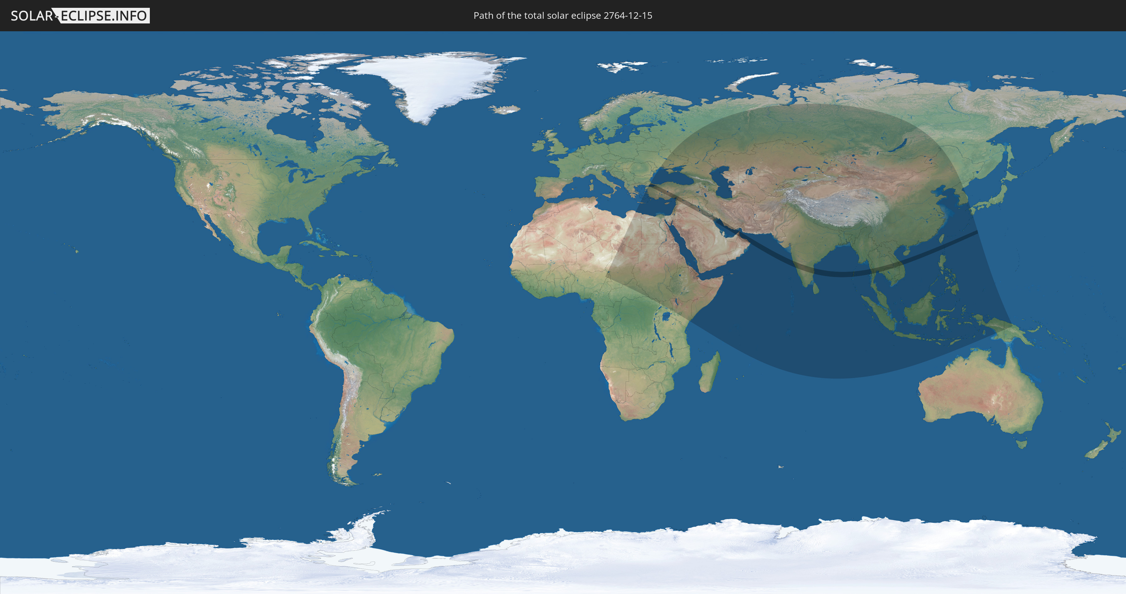
Die Sonnenfinsternis am 12/15/2764 kann man in 76 Ländern als partielle Sonnenfinsternis beobachten.
Der Finsternispfad verläuft durch 15 Länder. Nur in diesen Ländern ist sie als total Sonnenfinsternis zu sehen.
In den folgenden Ländern ist die Sonnenfinsternis total zu sehen
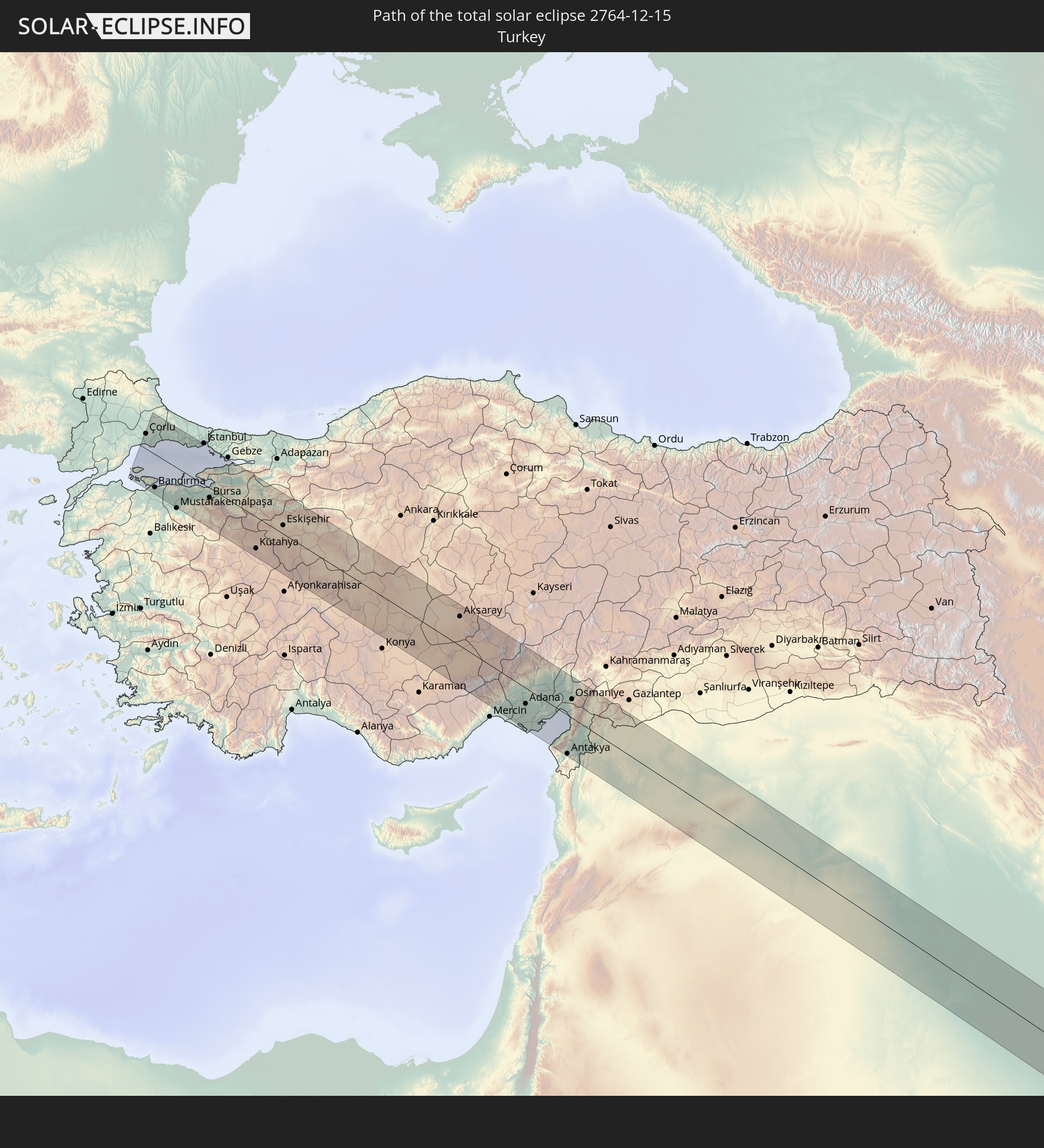 Turkey
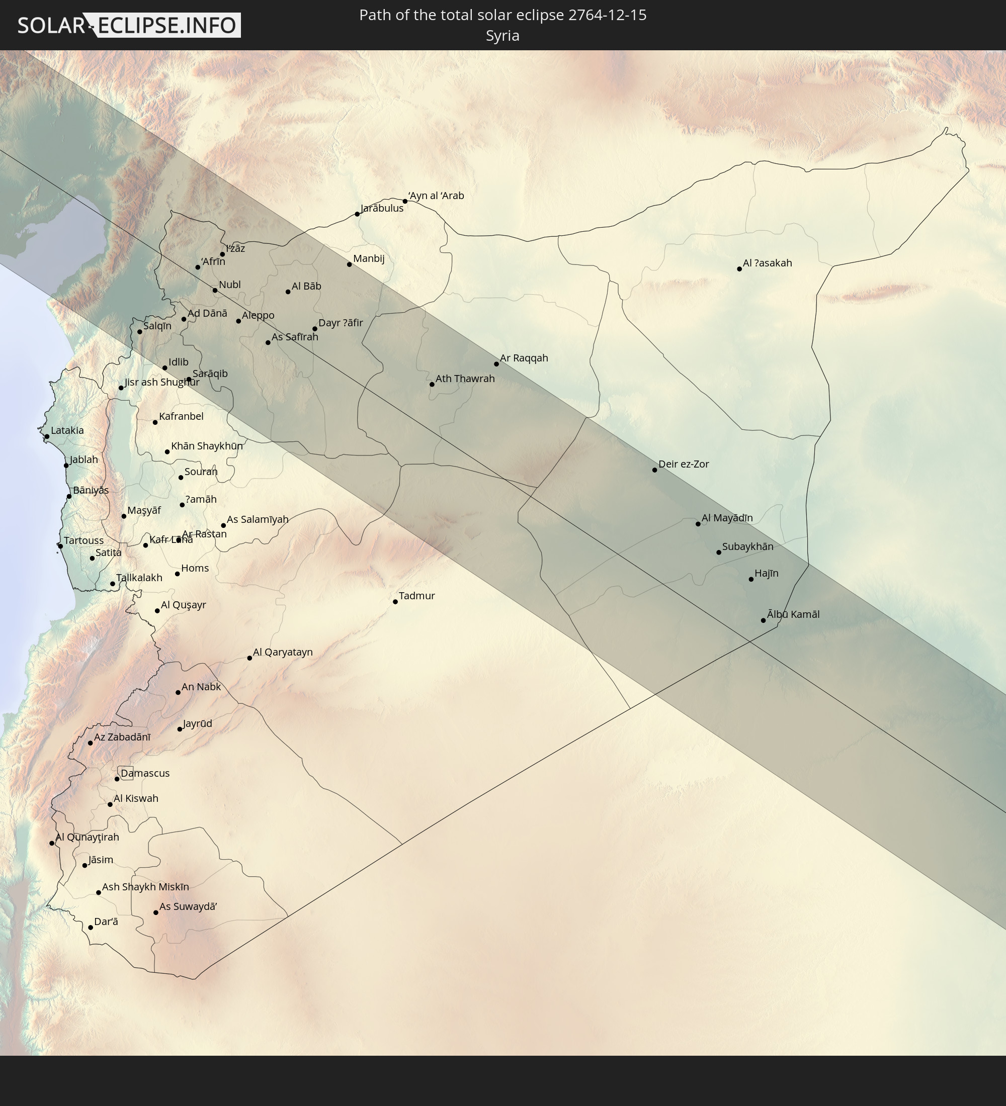 Syria
Syria
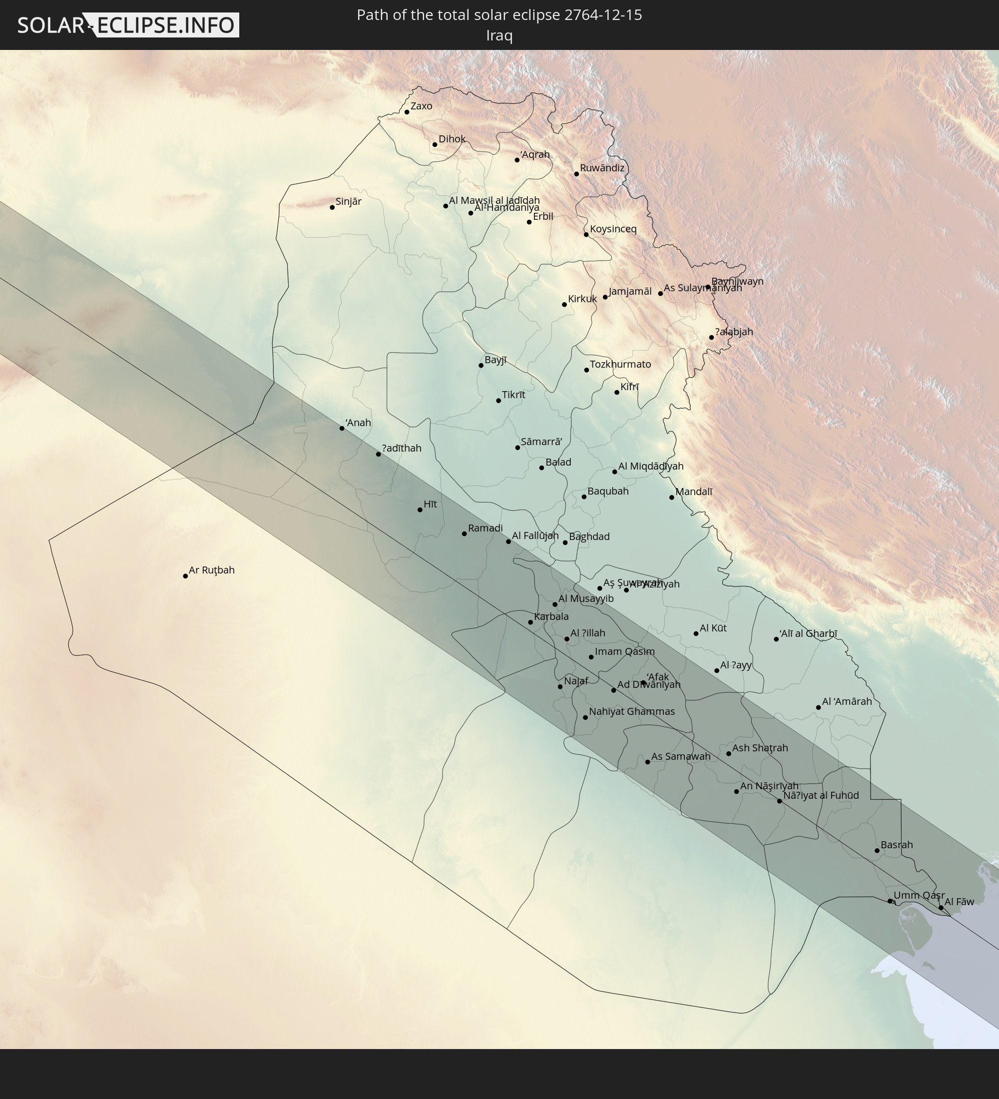 Iraq
Iraq
 Iran
Iran
 Kuwait
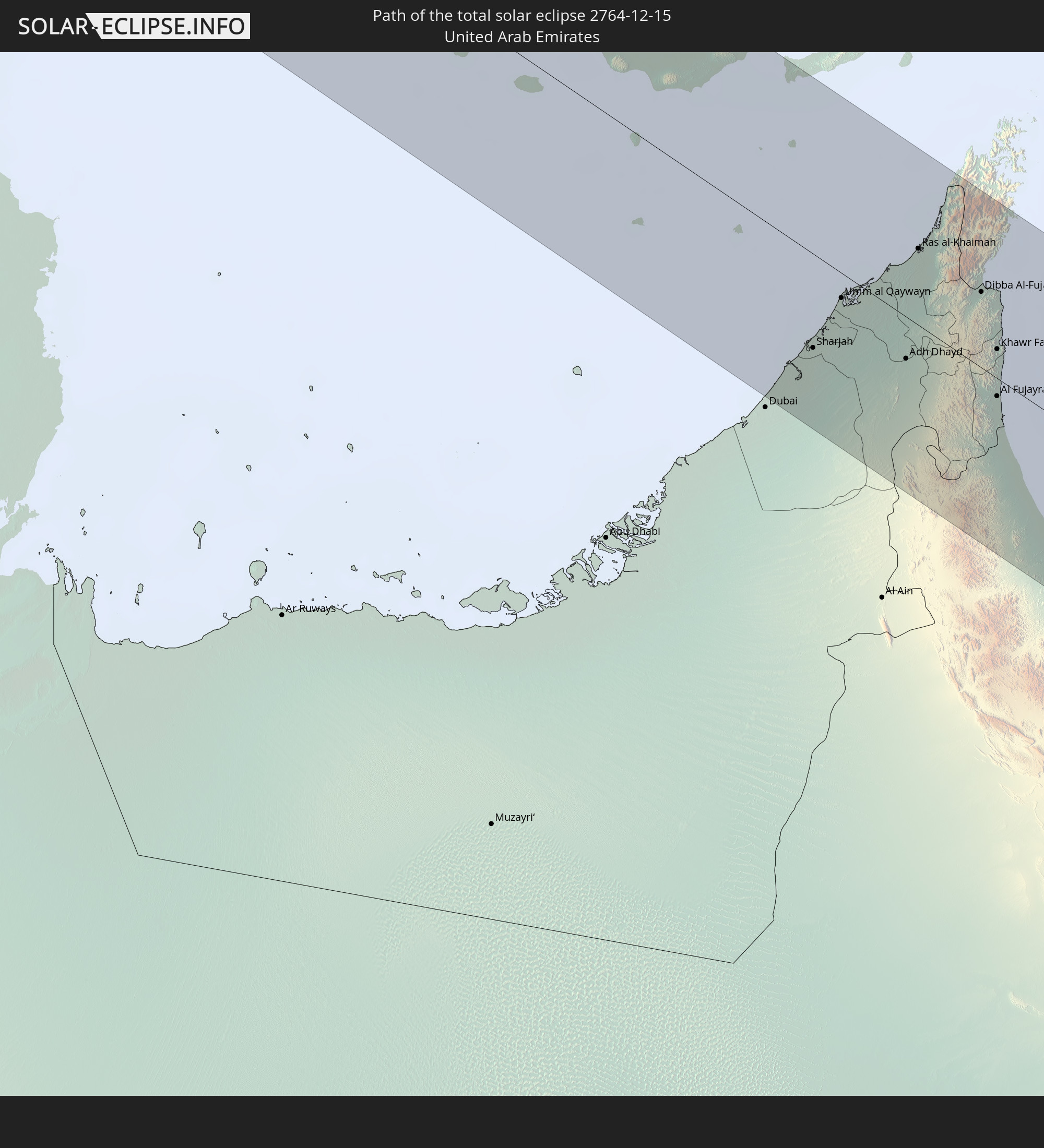 United Arab Emirates
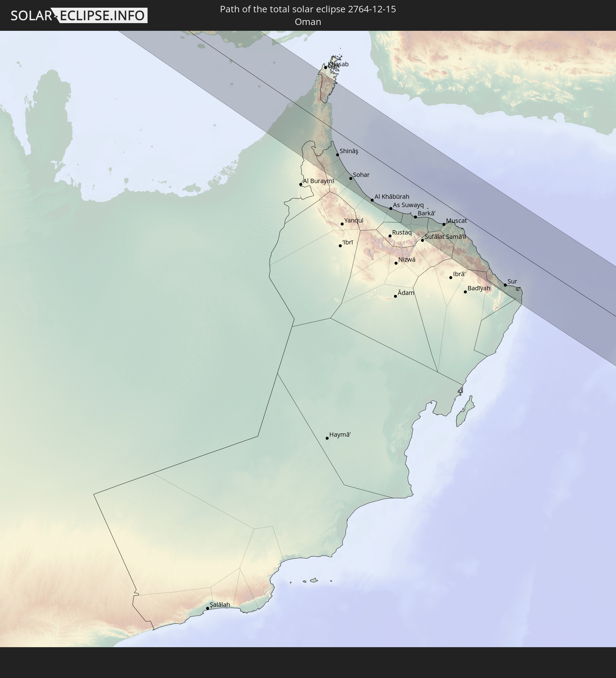 Oman
Oman
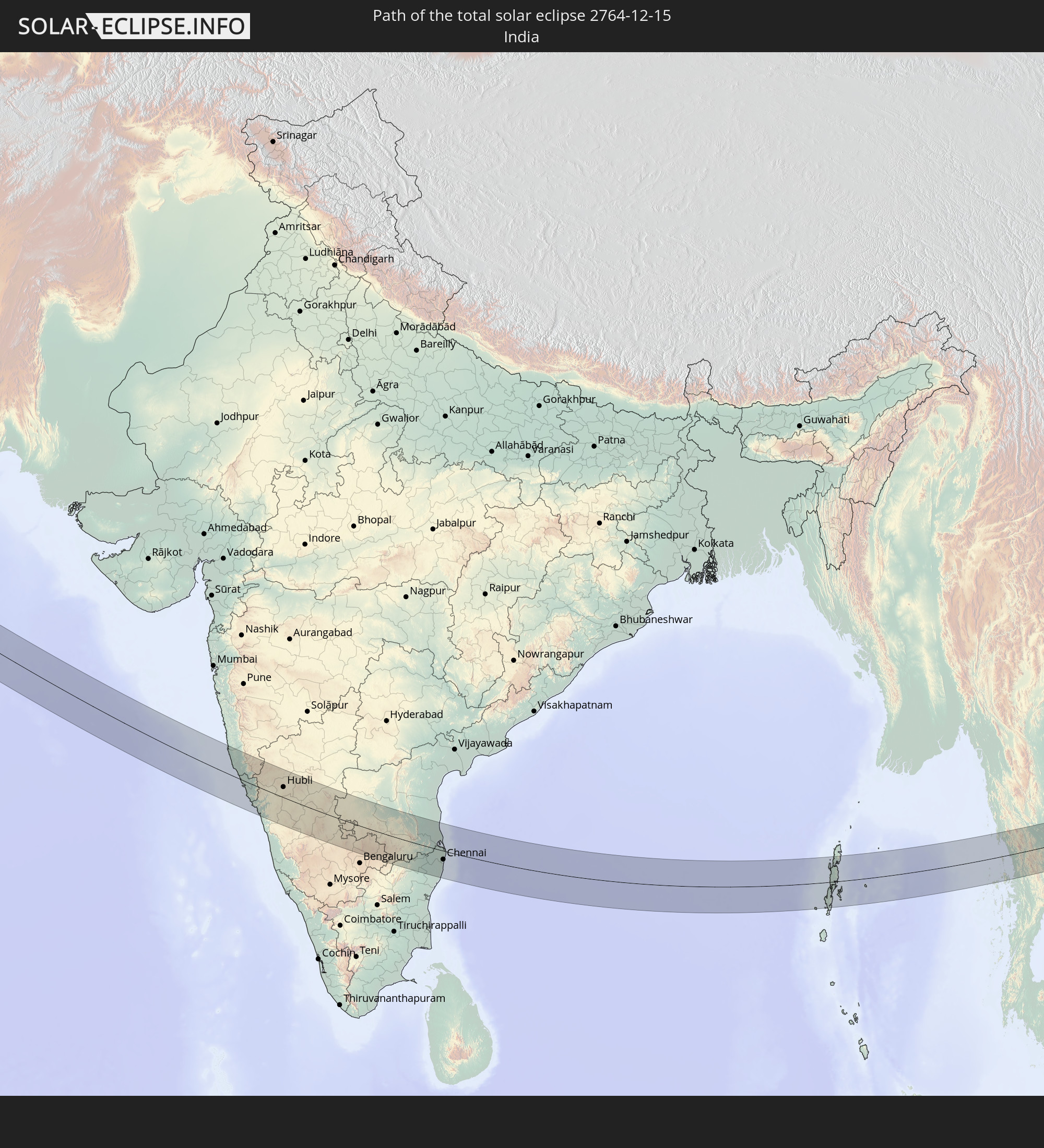 India
India
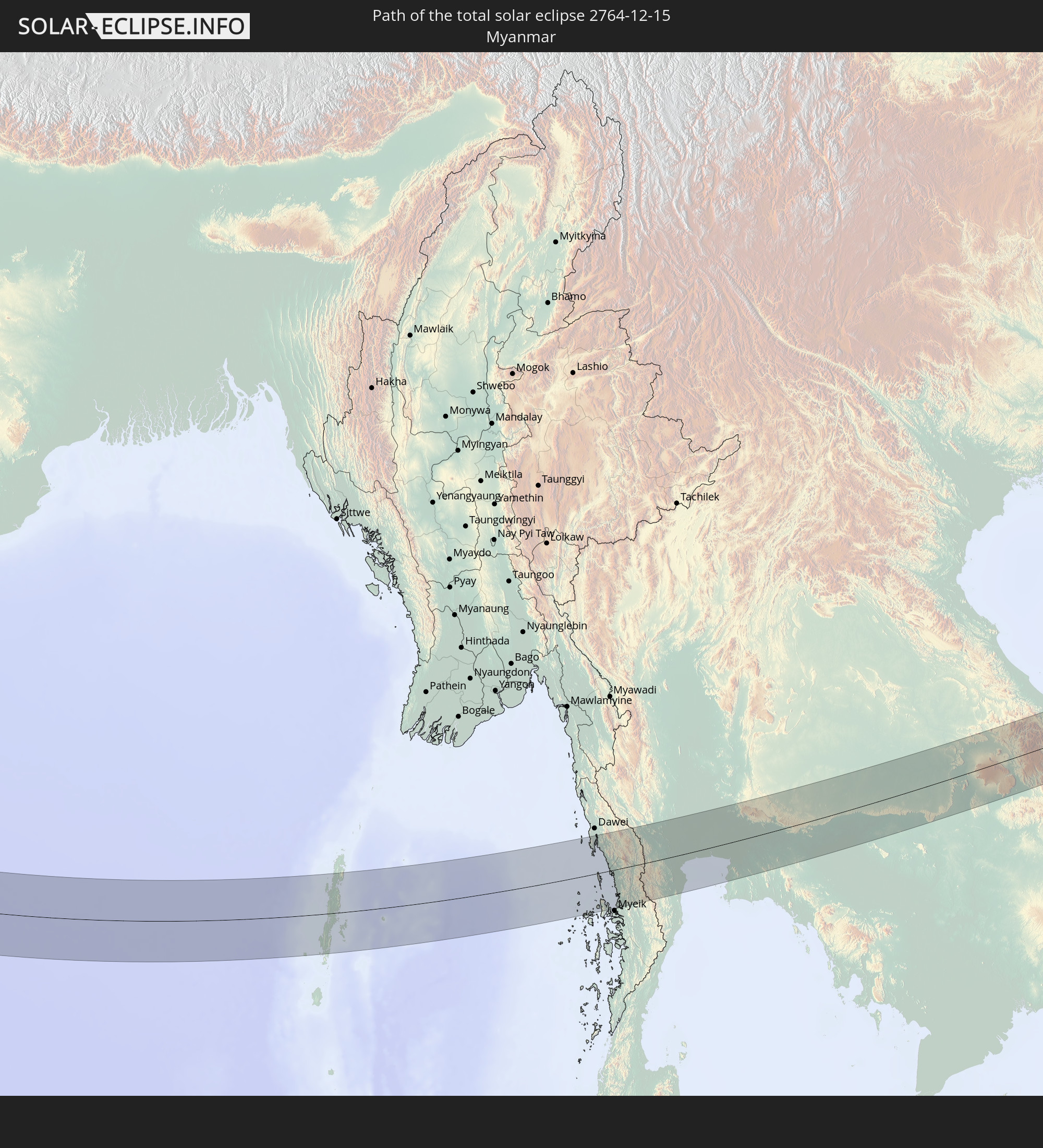 Myanmar
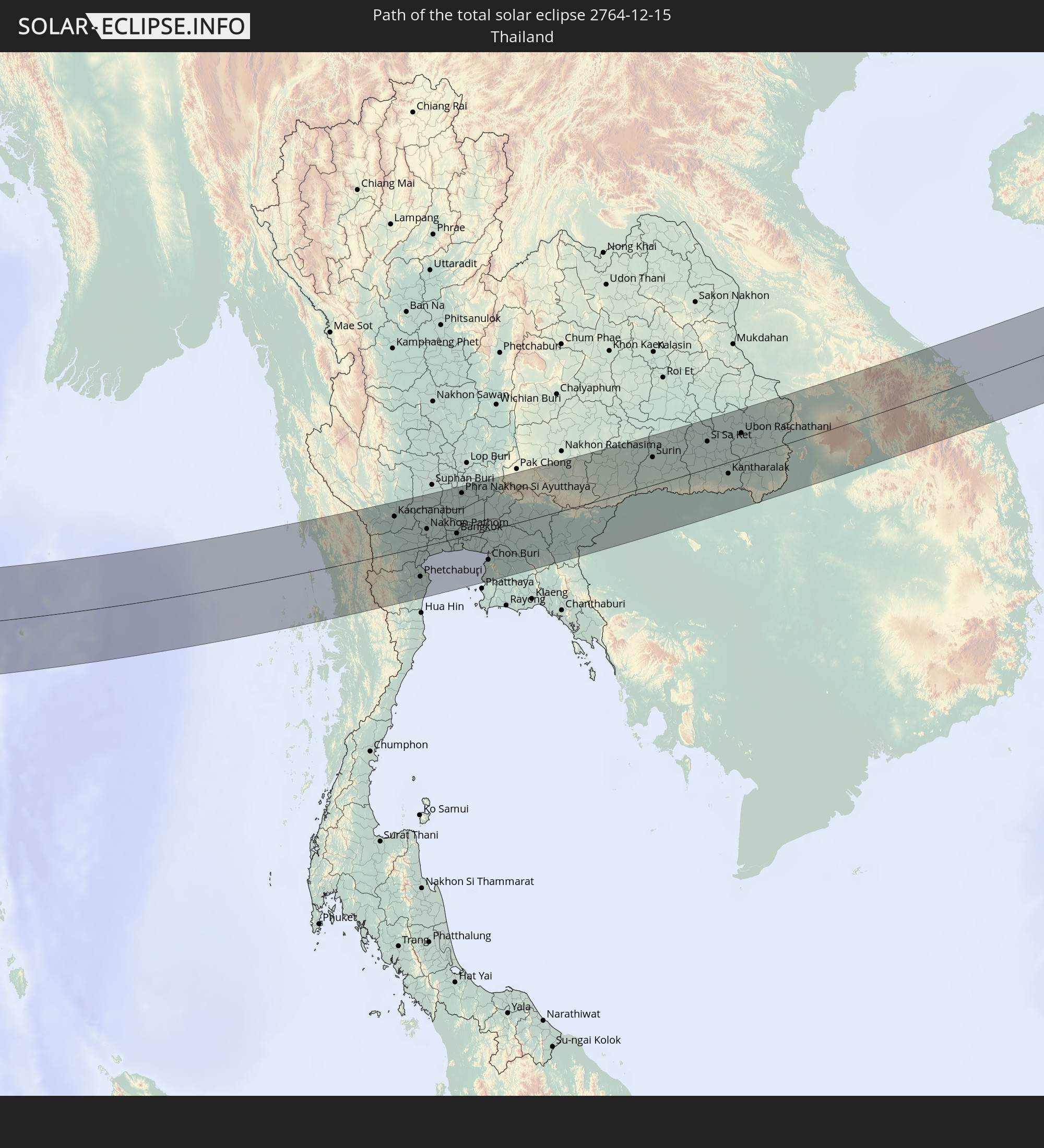 Thailand
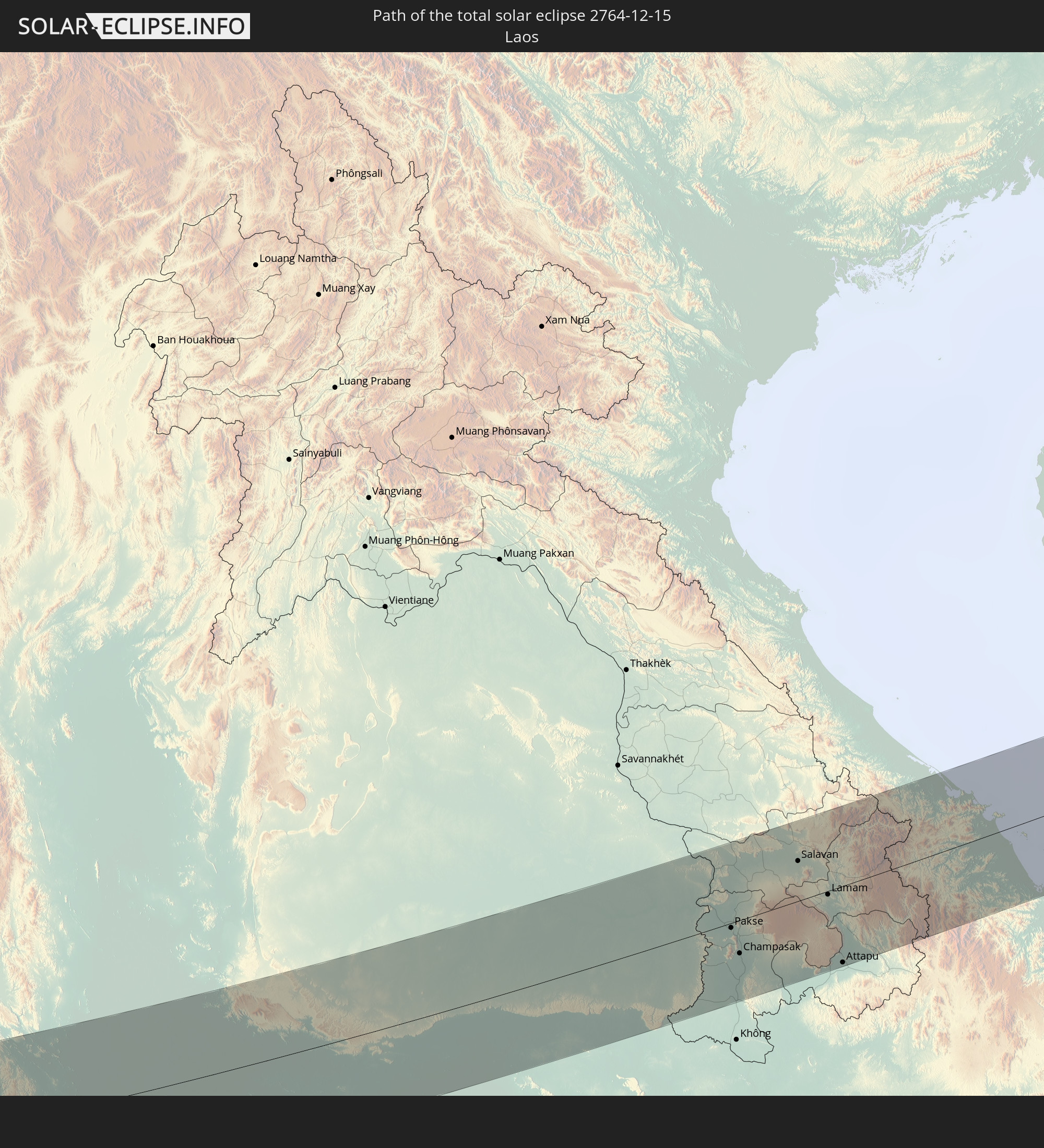 Laos
Laos
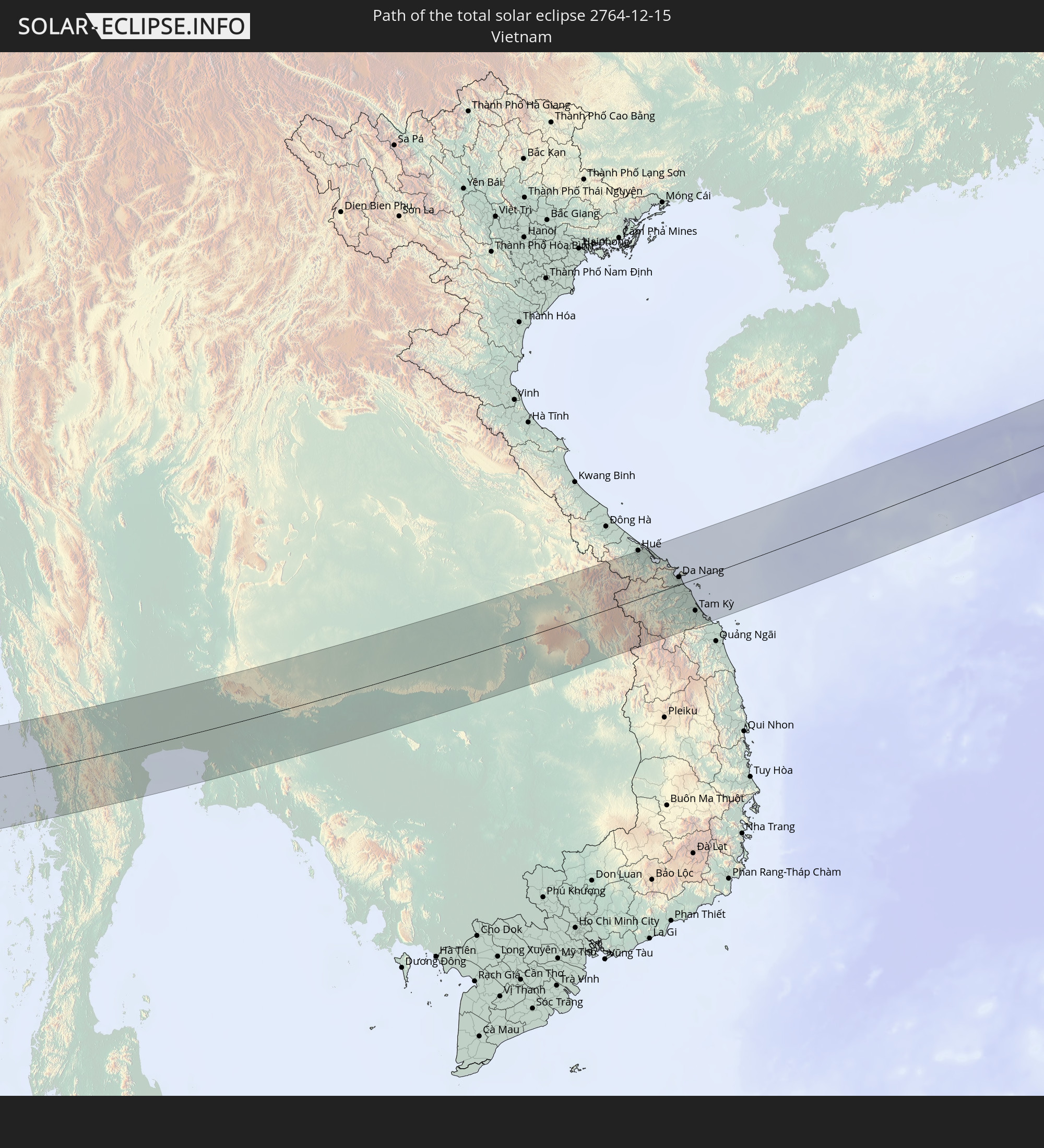 Vietnam
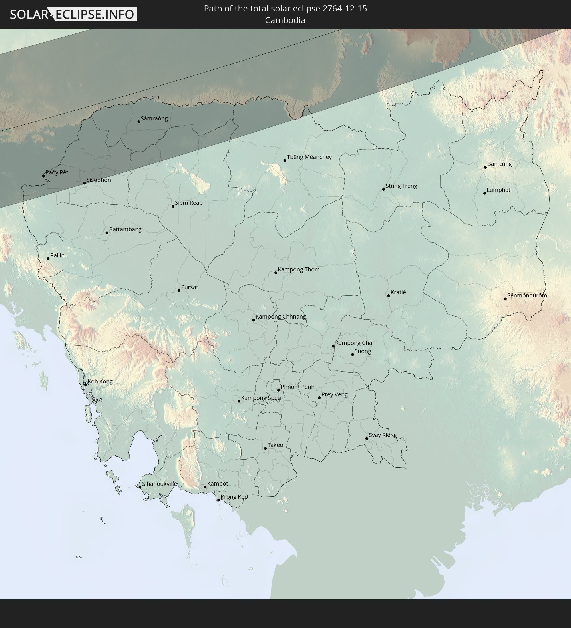 Cambodia
 Philippines
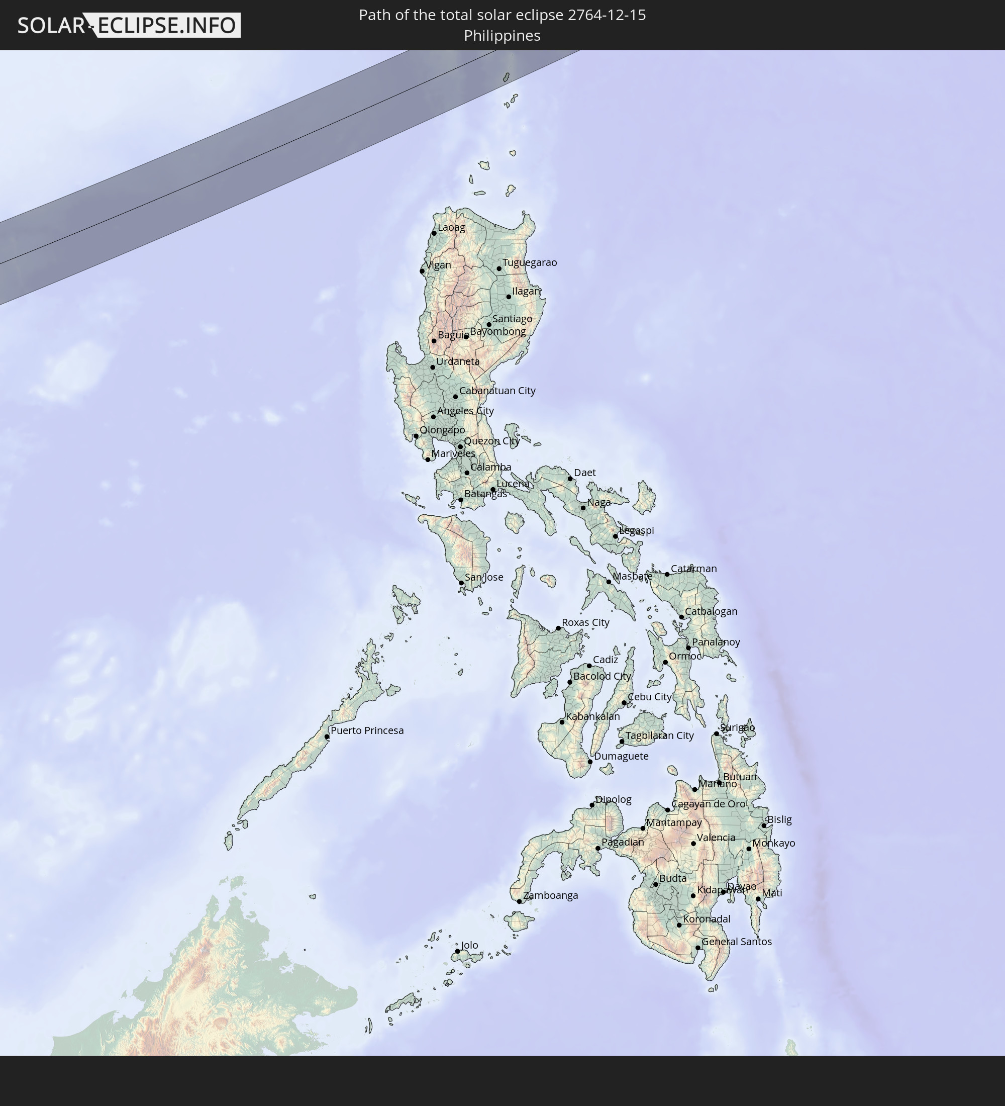
 Japan
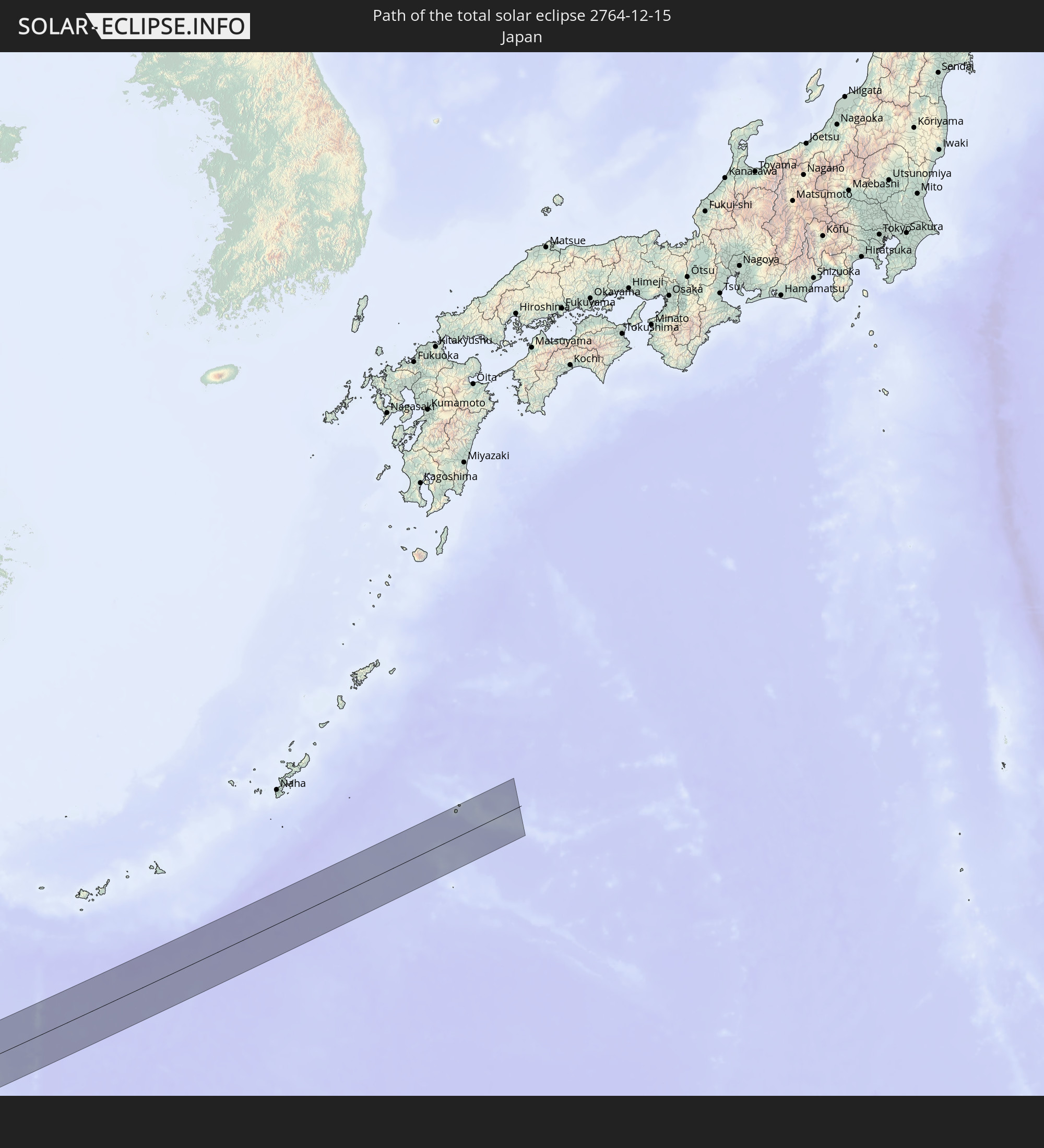
Japan
In den folgenden Ländern ist die Sonnenfinsternis partiell zu sehen
 Russia
 Nigeria
 Cameroon
 Libya
Libya
 Democratic Republic of the Congo
 Chad
Chad
 Central African Republic
 Greece
 Sudan
Sudan
 Ukraine
 Egypt
Egypt
 Turkey
 Uganda
 Cyprus
 Ethiopia
 Kenya
Kenya
 State of Palestine
 Israel
 Saudi Arabia
 Jordan
 Lebanon
 Syria
Syria
 Eritrea
 Iraq
Iraq
 Georgia
 Somalia
 Djibouti
 Yemen
Yemen
 Armenia
 Iran
Iran
 Azerbaijan
 Seychelles
 Kazakhstan
 Kuwait
 Bahrain
 Qatar
Qatar
 United Arab Emirates
 Oman
Oman
 Turkmenistan
 Uzbekistan
 Mauritius
 Afghanistan
 Pakistan
 Tajikistan
 India
India
 Kyrgyzstan
 British Indian Ocean Territory
 Maldives
 China
China
 Sri Lanka
 Nepal
Nepal
 Mongolia
 Bangladesh
 Bhutan
 Myanmar
 Indonesia
 Cocos Islands
 Thailand
 Malaysia
 Laos
Laos
 Vietnam
 Cambodia
 Singapore
 Christmas Island
 Australia
 Macau
Macau
 Hong Kong
 Brunei
 Taiwan
 Philippines
 Japan
Japan
 East Timor
 North Korea
 South Korea
 Palau
Palau
 Papua New Guinea
How will be the weather during the total solar eclipse on 12/15/2764?
Where is the best place to see the total solar eclipse of 12/15/2764?
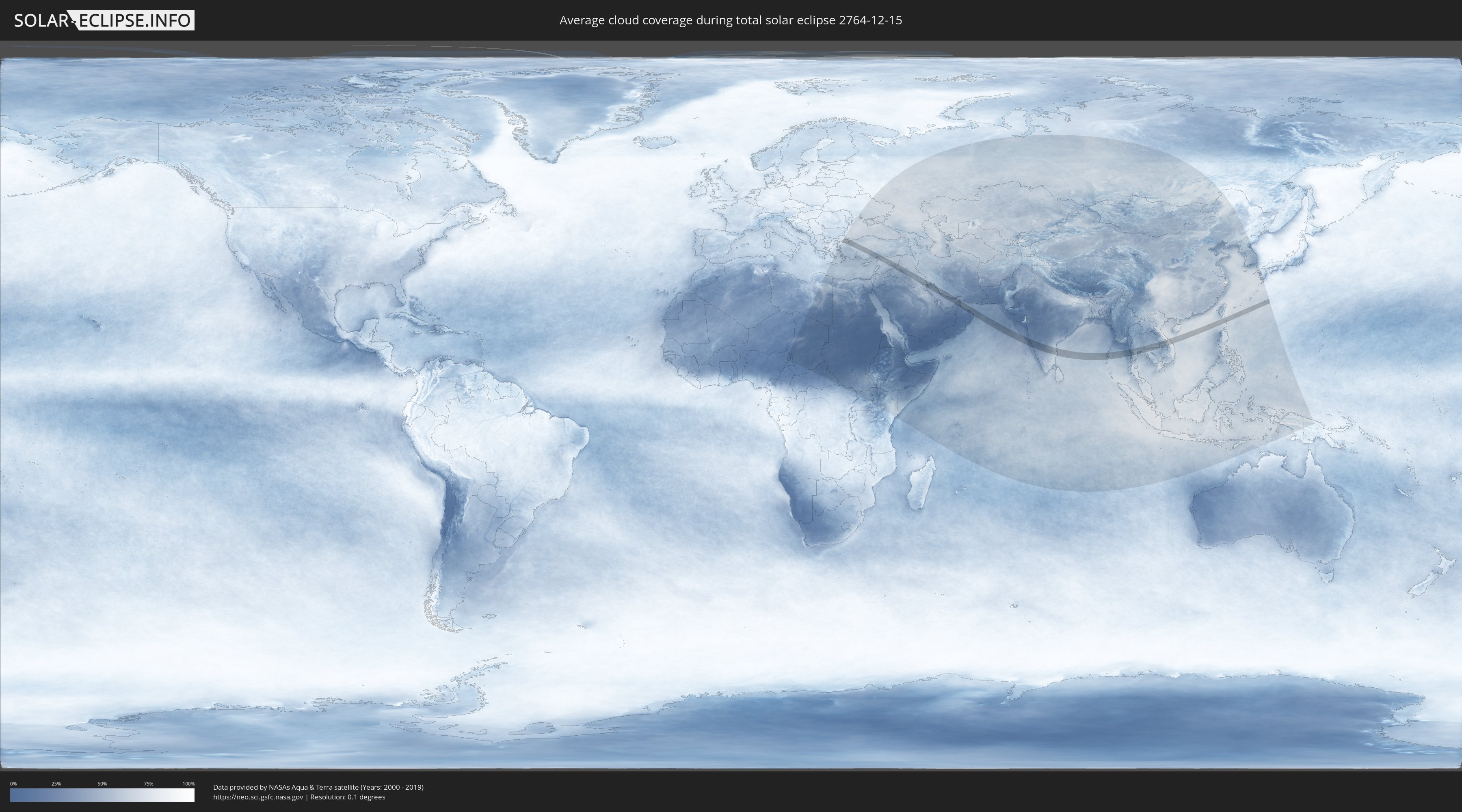
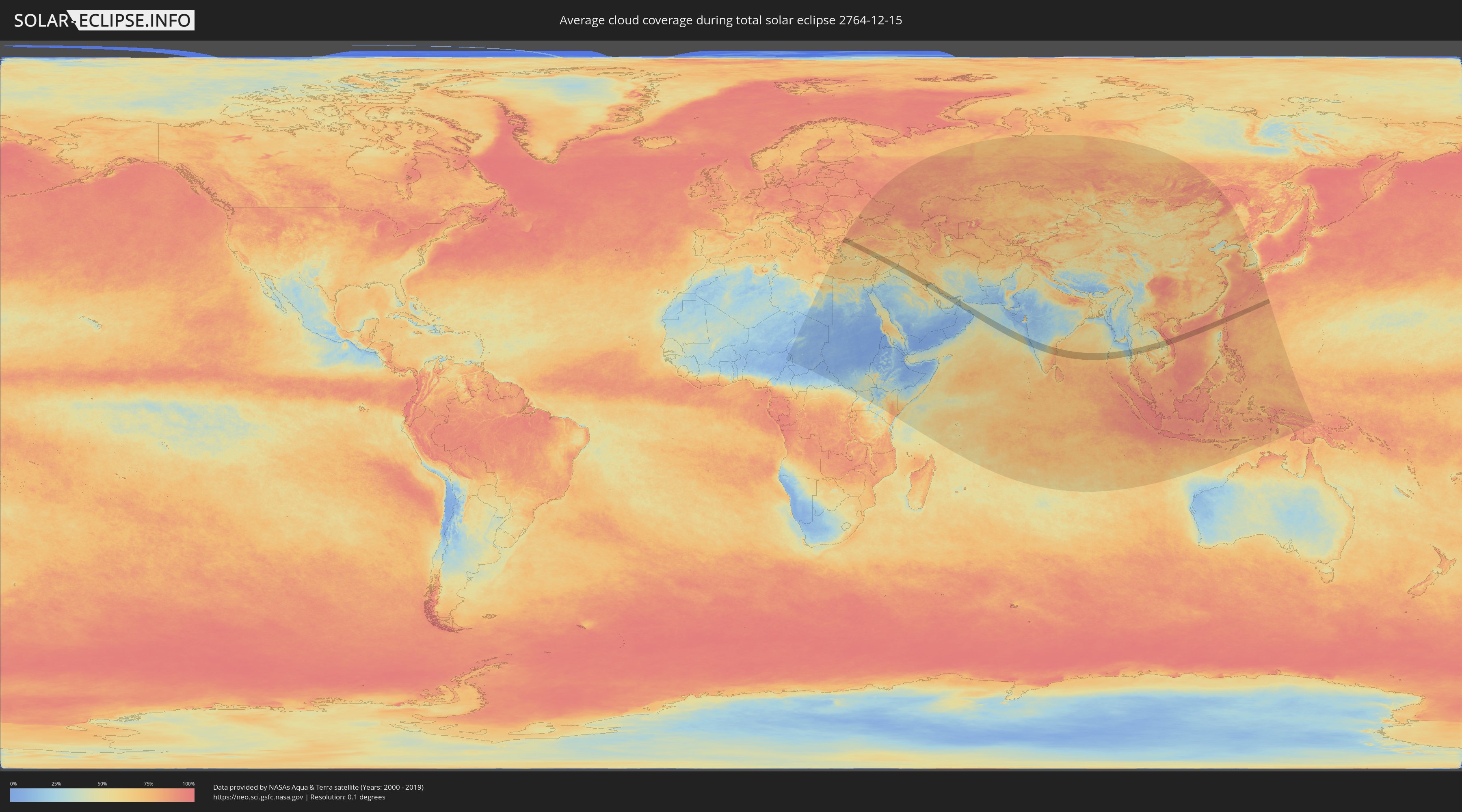
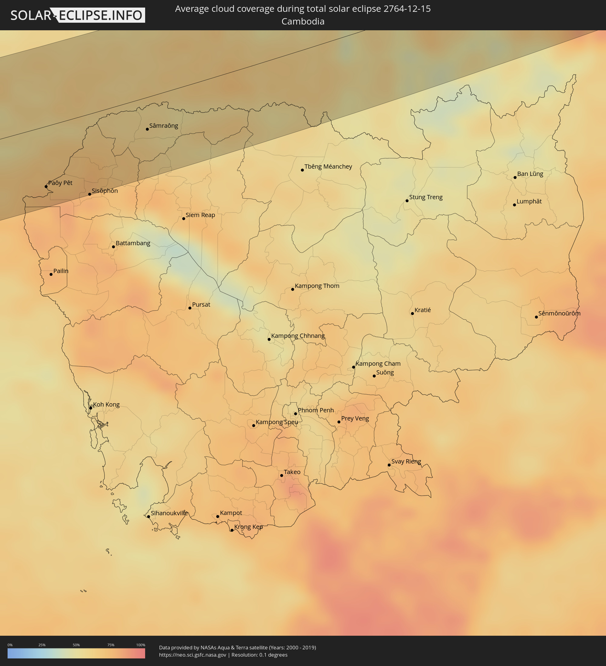
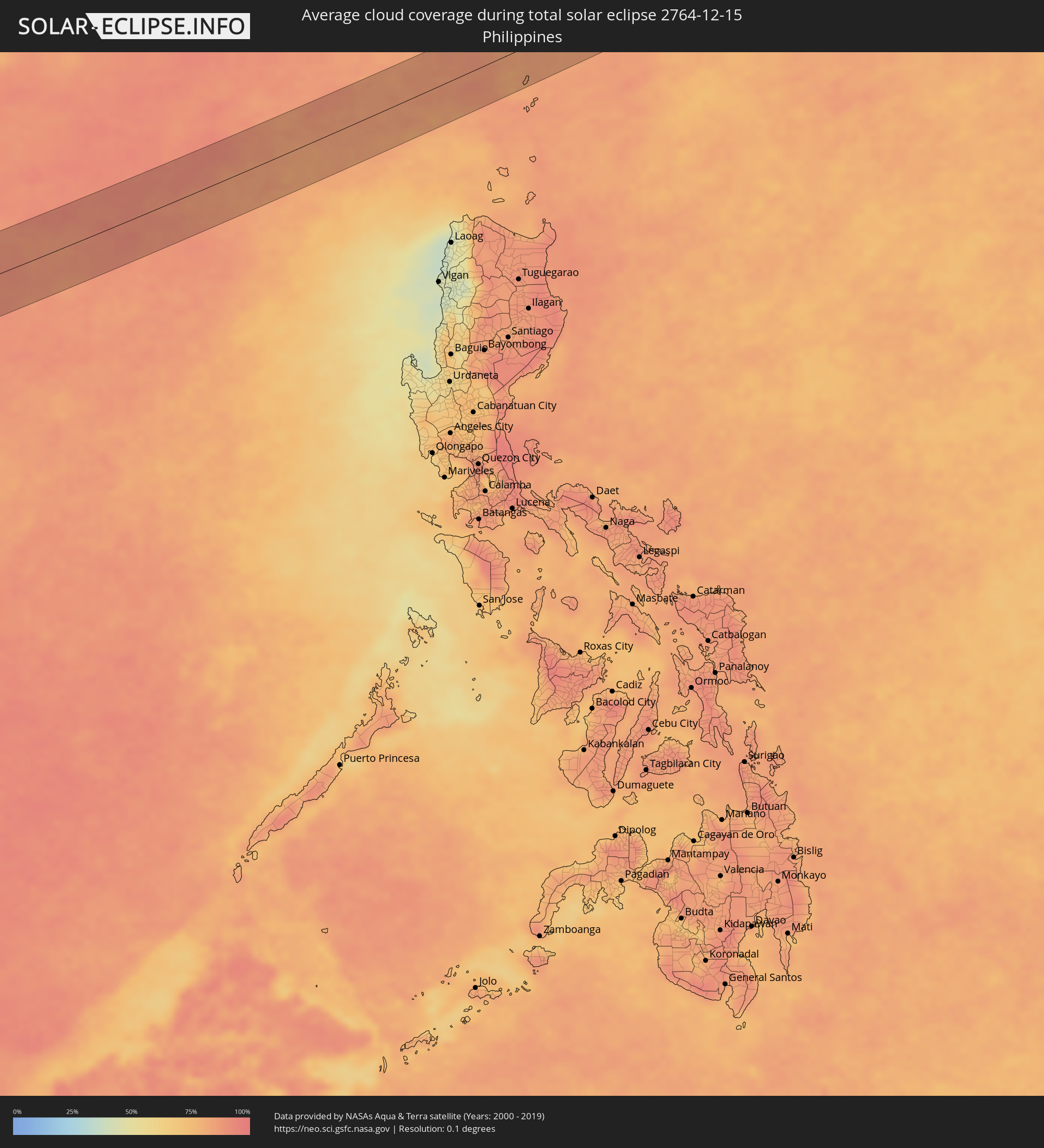
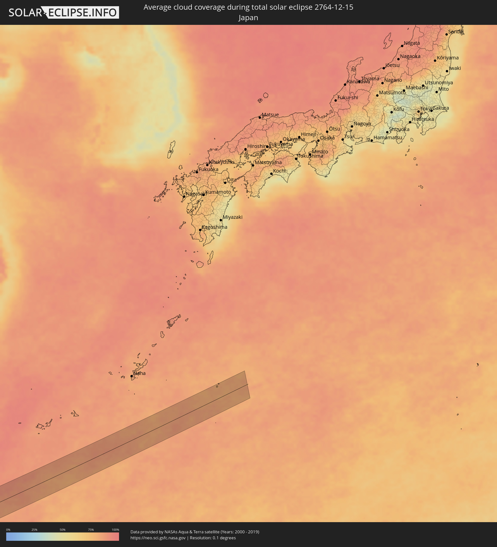
The following maps show the average cloud coverage for the day of the total solar eclipse.
With the help of these maps, it is possible to find the place along the eclipse path, which has the best
chance of a cloudless sky.
Nevertheless, you should consider local circumstances and inform about the weather of your chosen
observation site.
The data is provided by NASAs satellites
AQUA and TERRA.
The cloud maps are averaged over a period of 19 years (2000 - 2019).
Detailed country maps
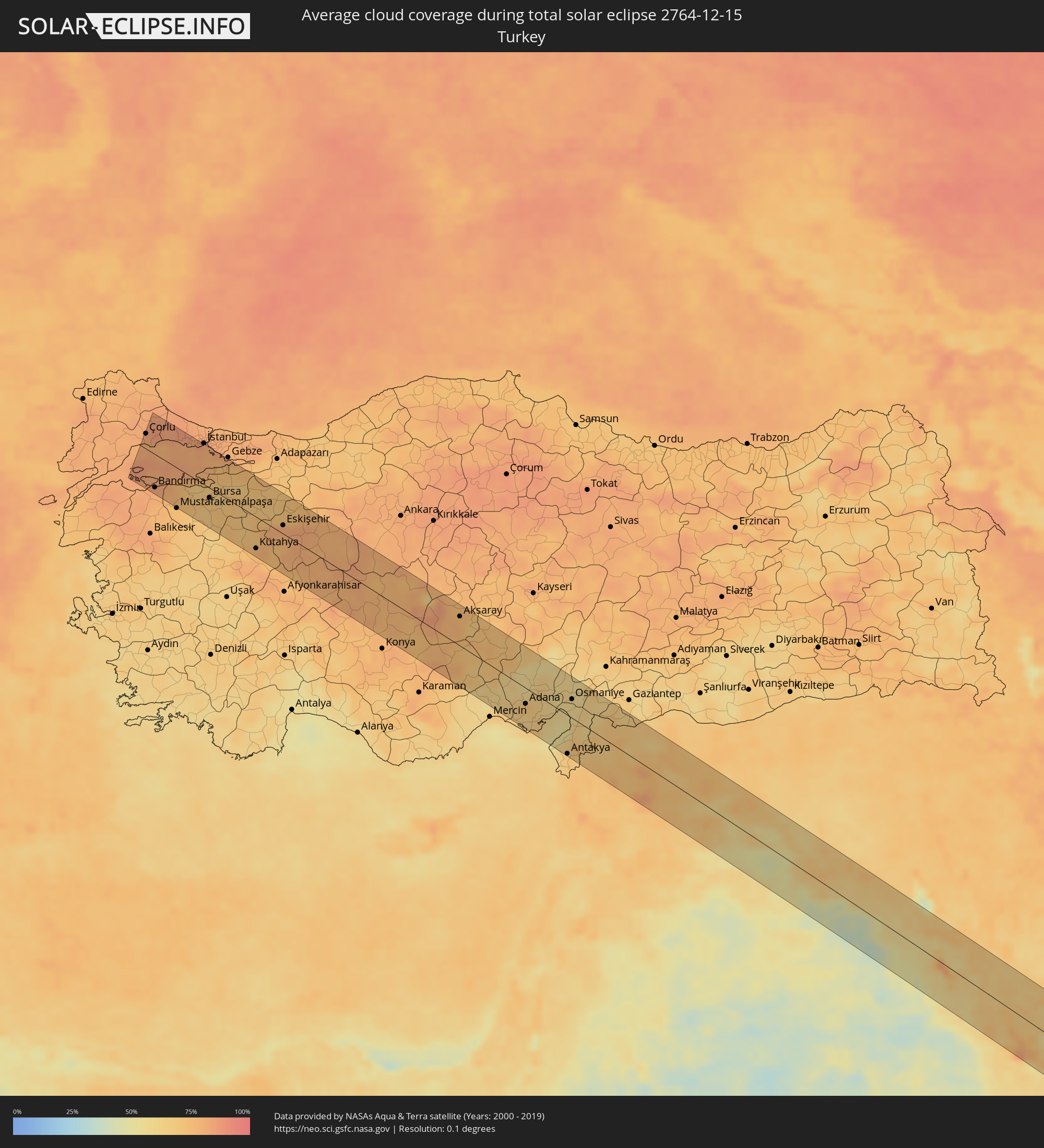 Turkey
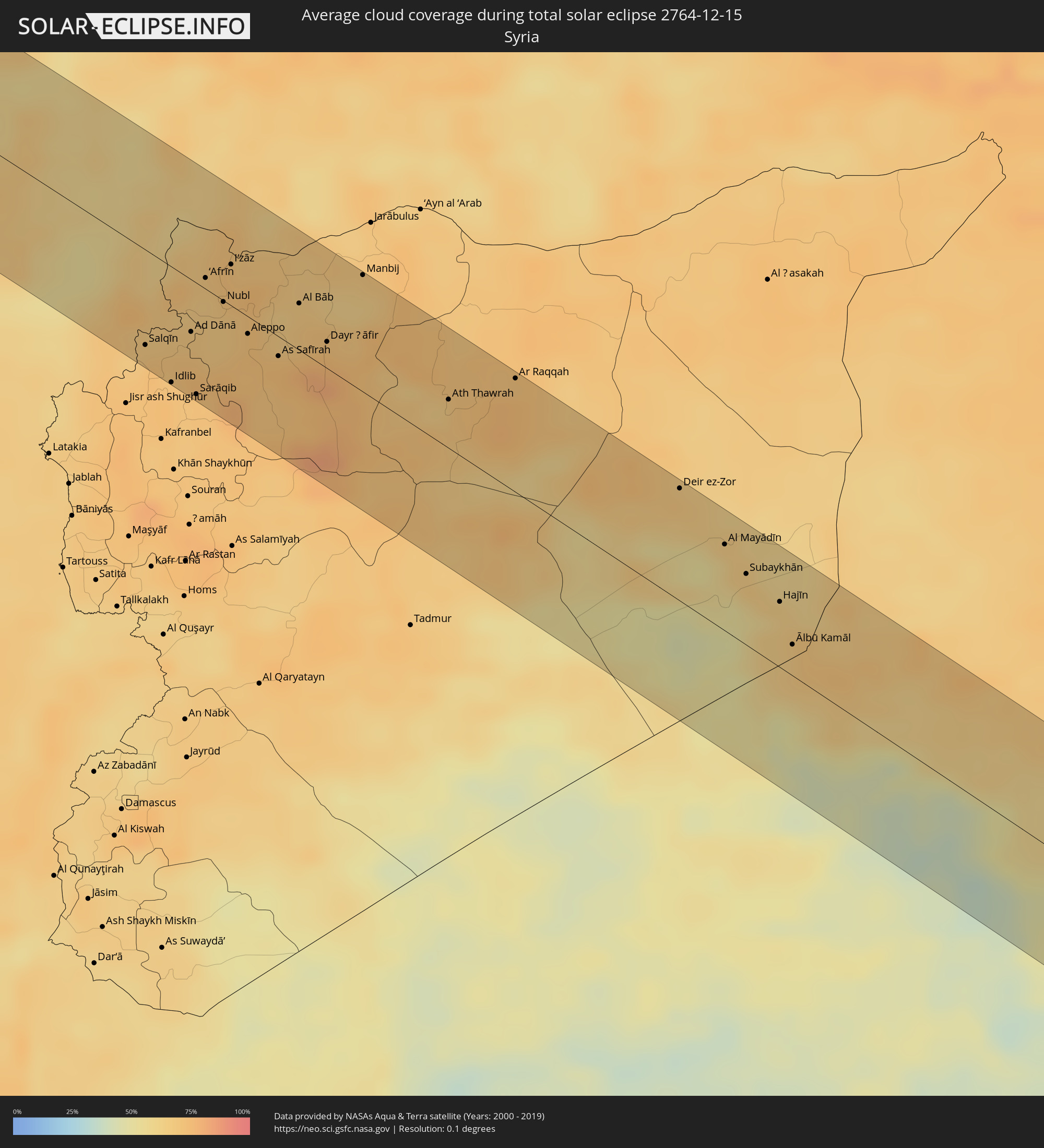 Syria
Syria
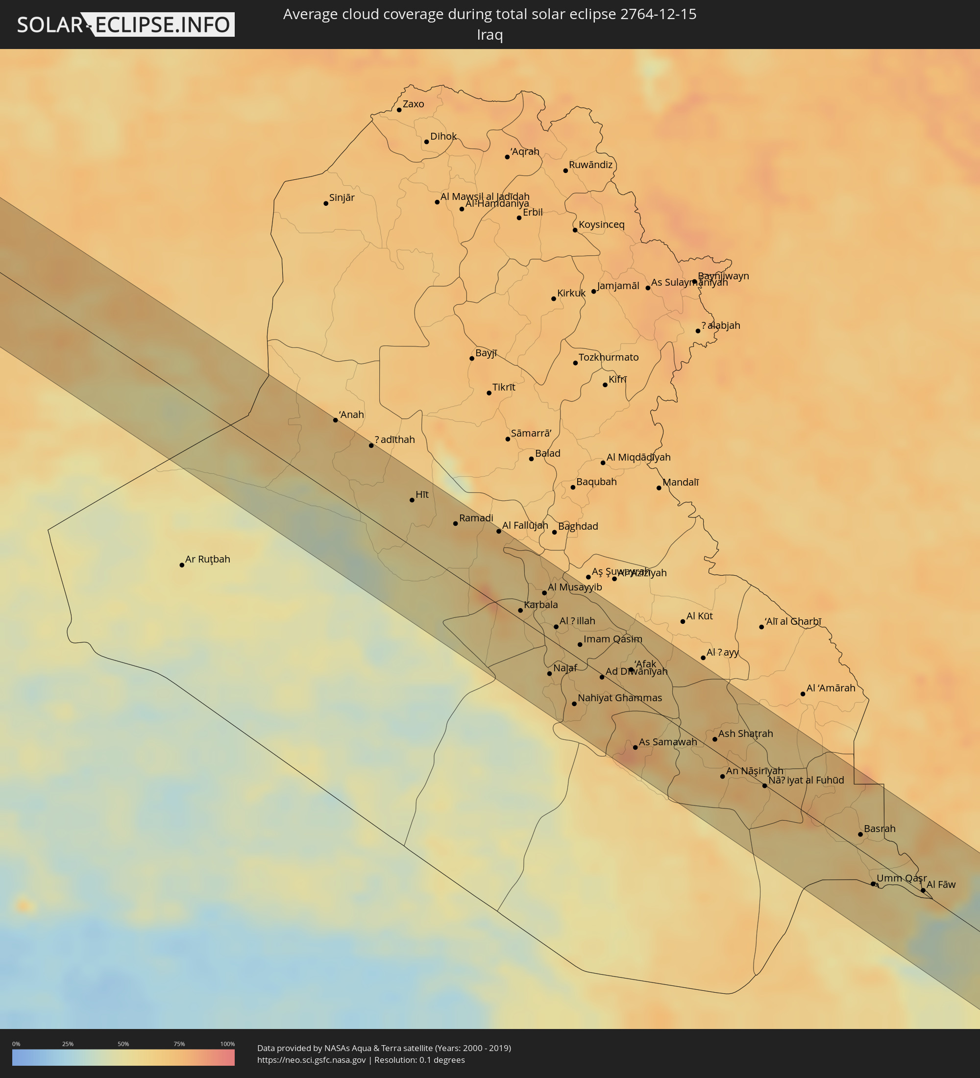 Iraq
Iraq
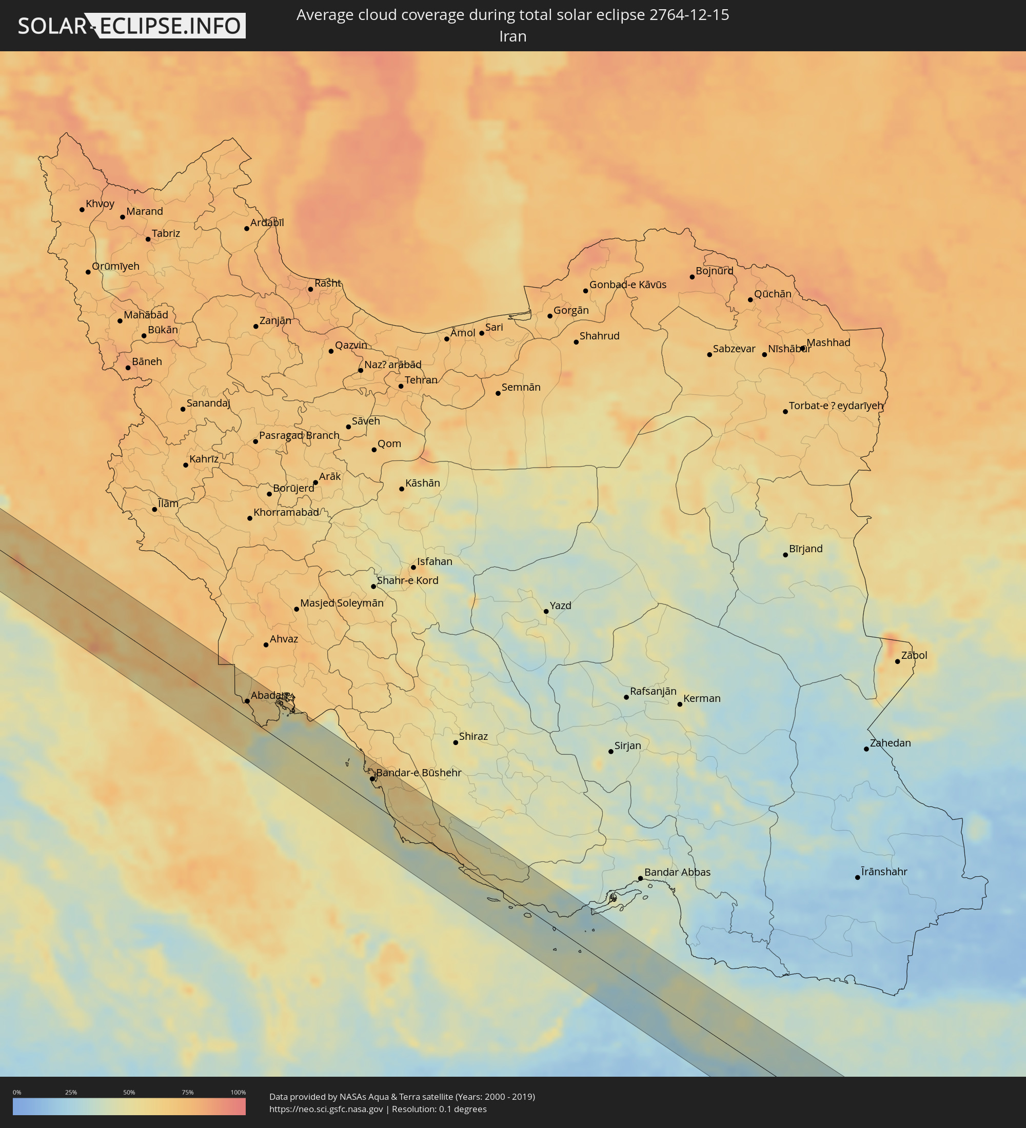 Iran
Iran
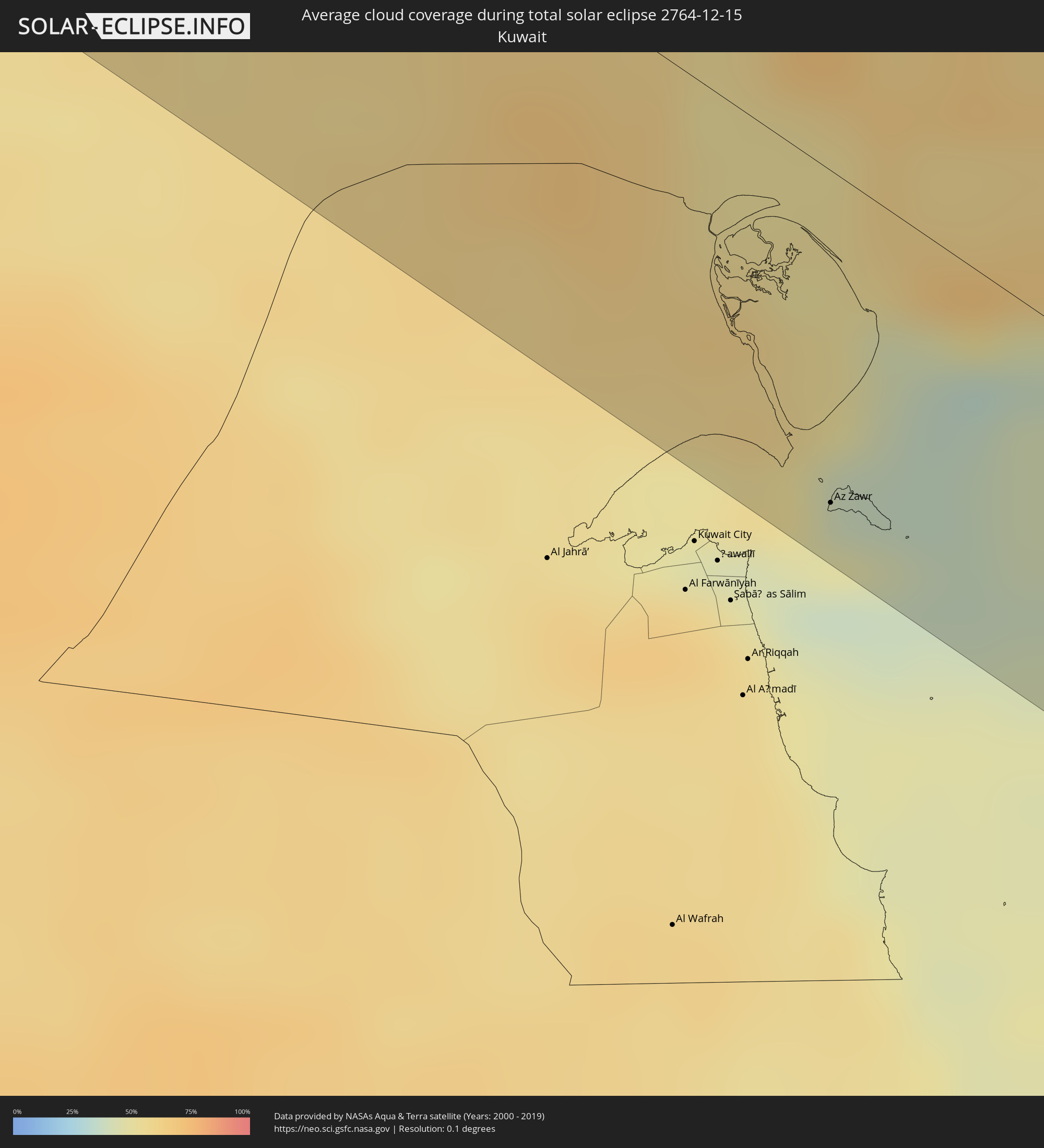 Kuwait
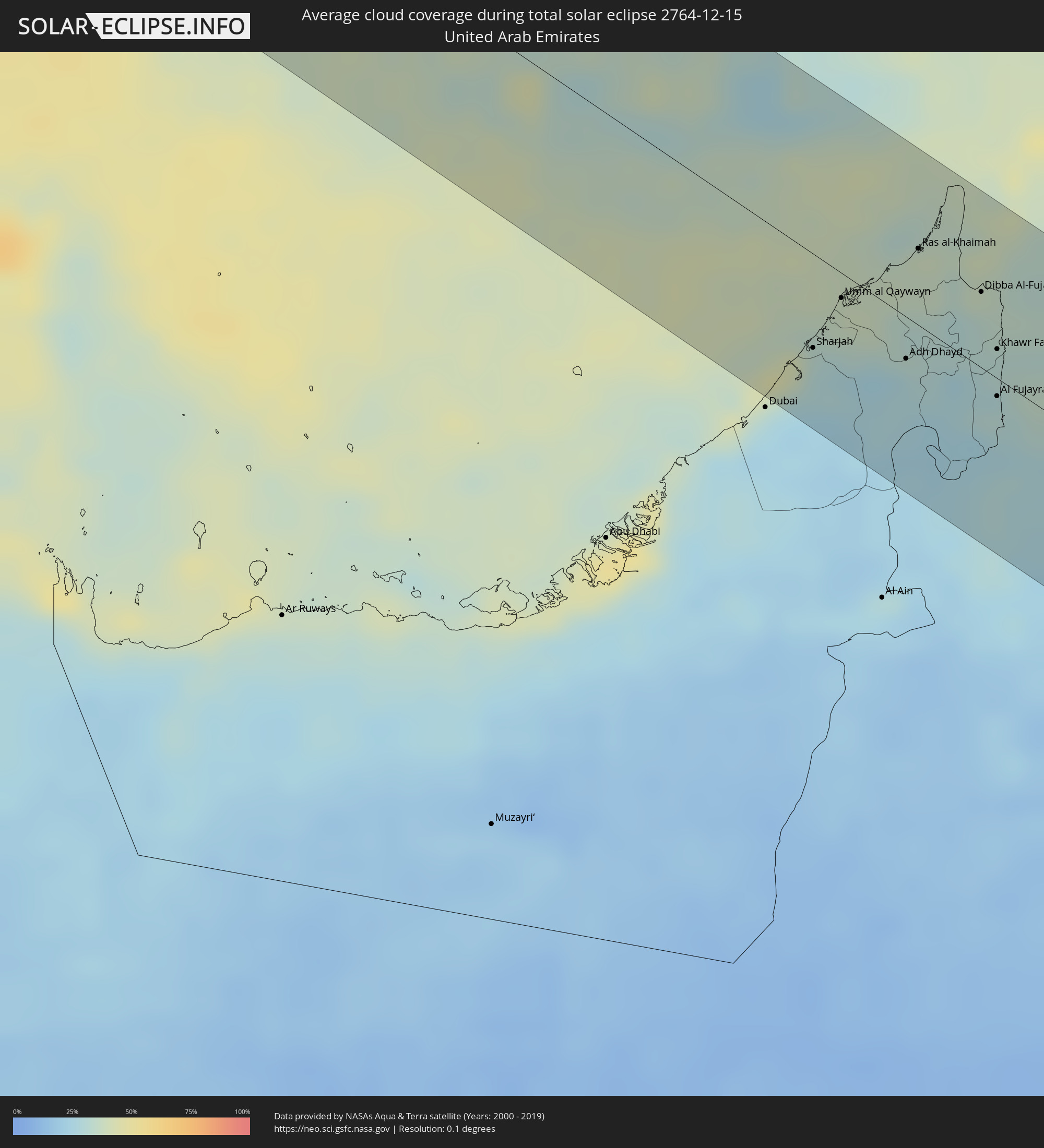 United Arab Emirates
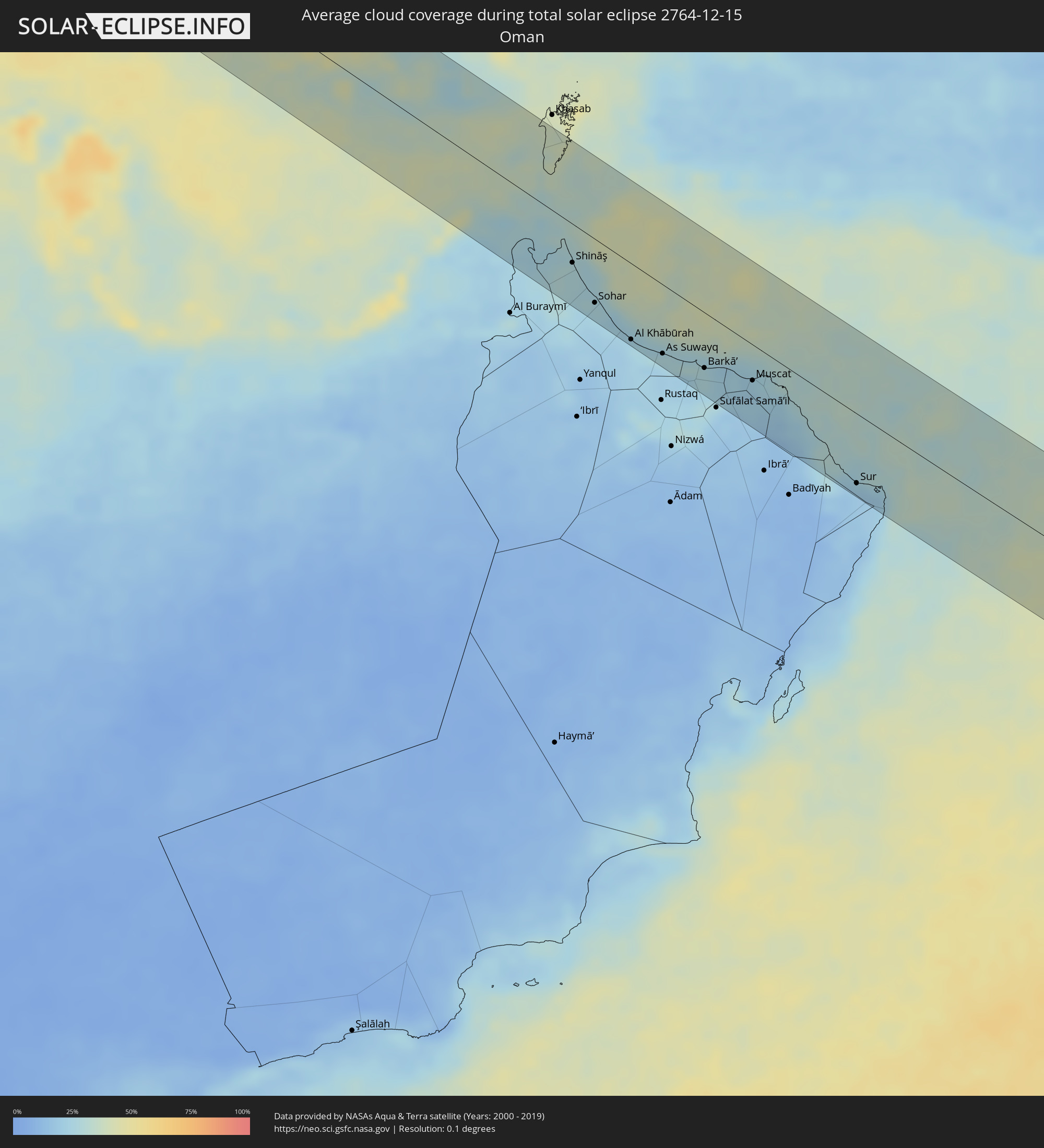 Oman
Oman
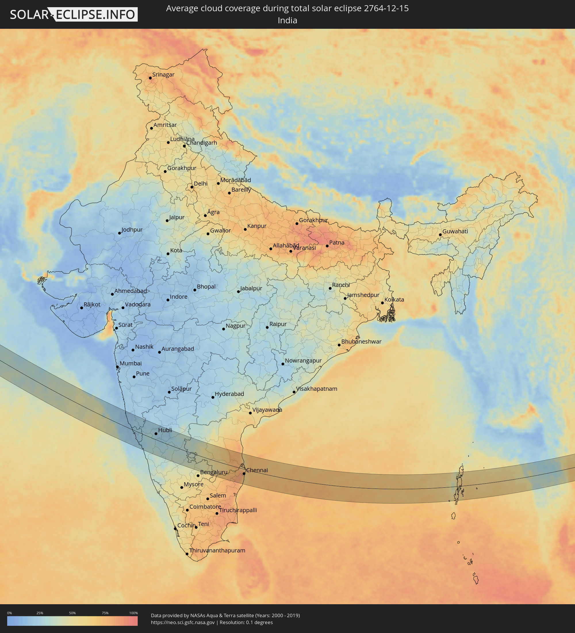 India
India
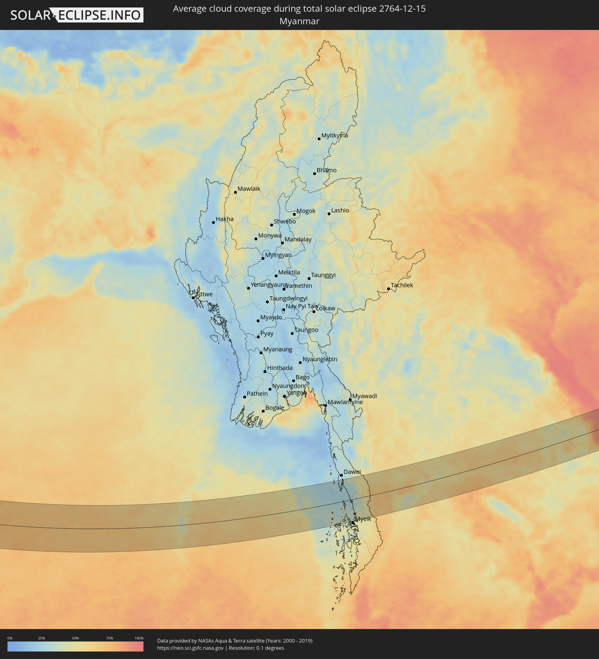 Myanmar
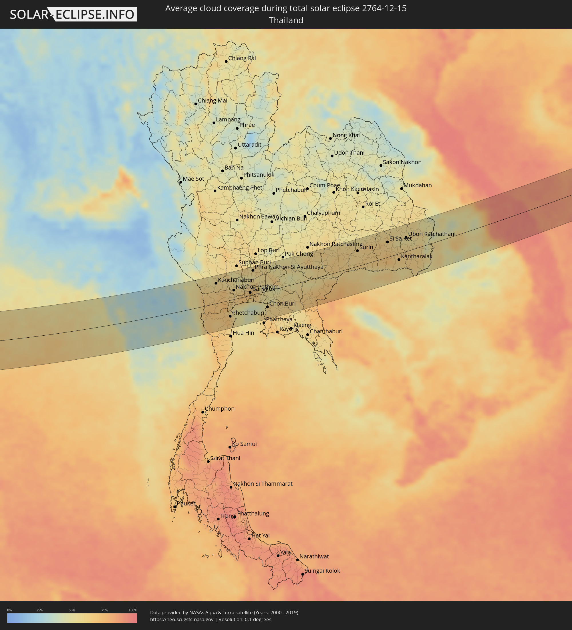 Thailand
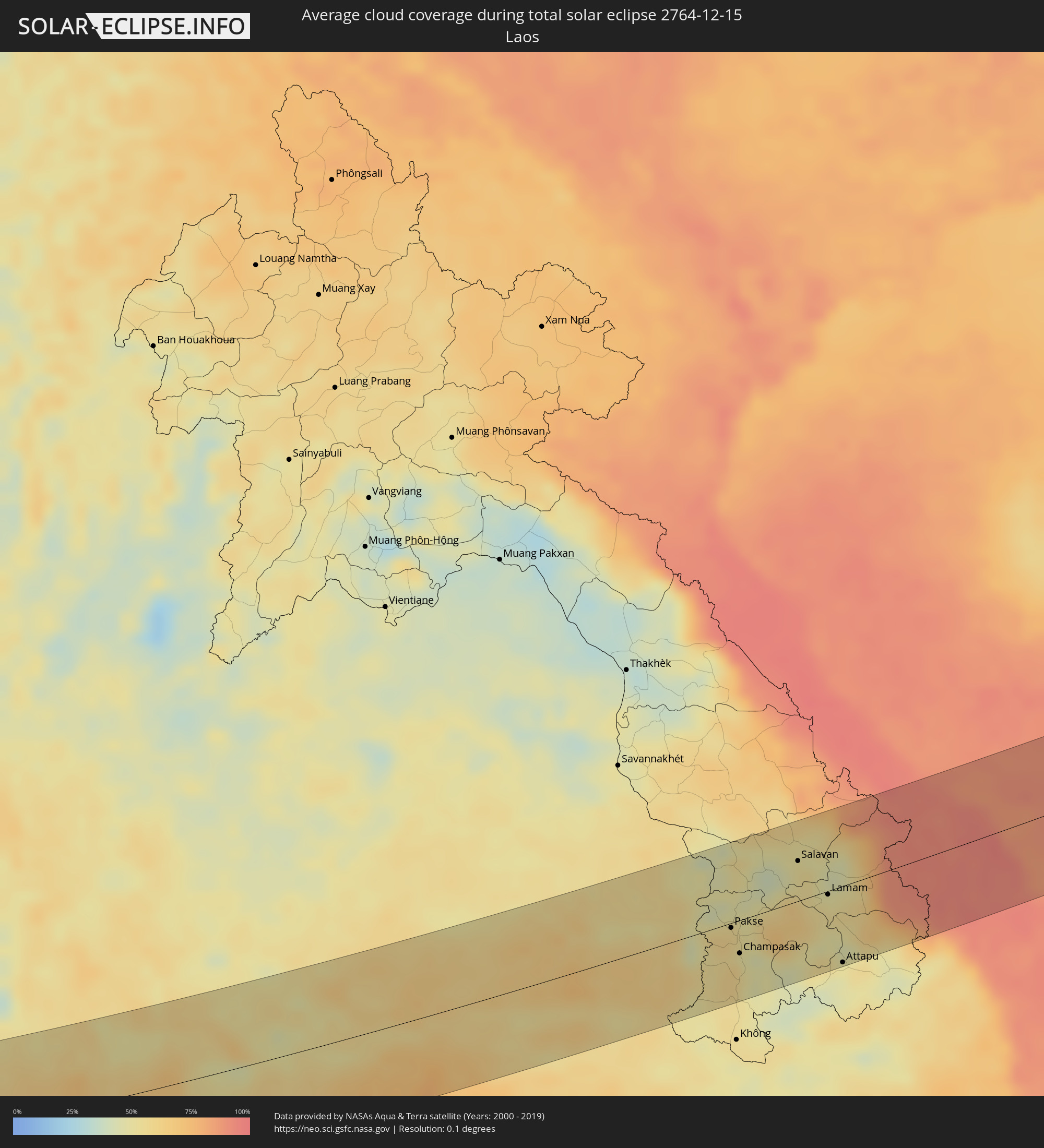 Laos
Laos
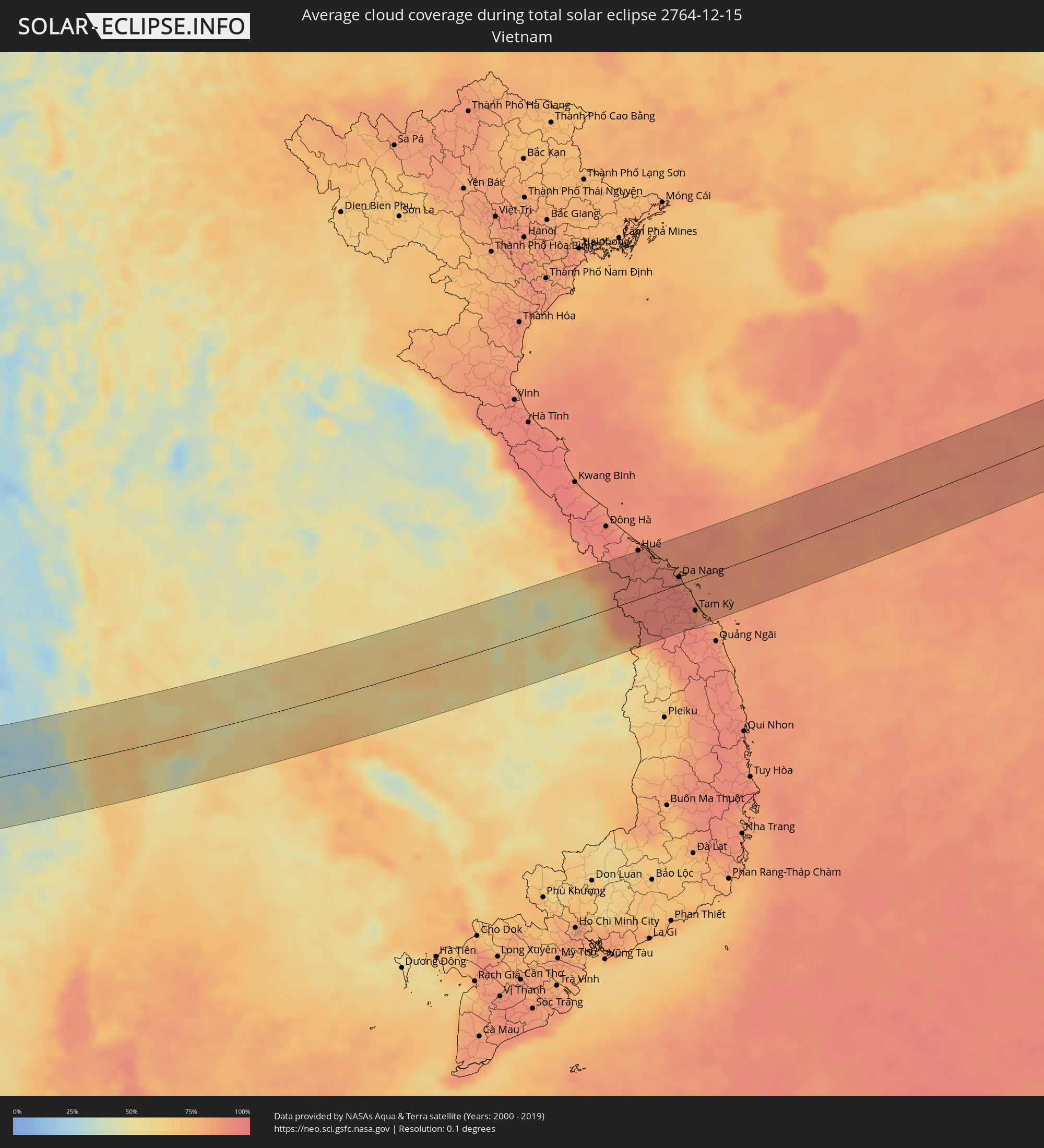 Vietnam
 Cambodia
 Philippines
 Japan
Japan
Cities inside the path of the eclipse
The following table shows all locations with a population of more than 5,000 inside the eclipse path. Cities which have more than 100,000 inhabitants are marked bold. A click at the locations opens a detailed map.
| City | Type | Eclipse duration | Local time of max. eclipse | Distance to central line | Ø Cloud coverage |
|
Çorlu, Tekirdağ
|
total | - | 08:30:35 UTC+03:00 | 22 km | 82% |
|
Bandırma, Balıkesir
|
total | - | 08:30:01 UTC+03:00 | 47 km | 82% |
|
Esenyurt, Istanbul
|
total | - | 08:30:49 UTC+03:00 | 48 km | 79% |
|
Bağcılar, Istanbul
|
total | - | 08:30:54 UTC+03:00 | 57 km | 80% |
|
Bursa, Bursa
|
total | - | 08:30:20 UTC+03:00 | 14 km | 71% |
|
İnegol, Bursa
|
total | - | 08:30:26 UTC+03:00 | 5 km | 72% |
|
Kütahya, Kütahya
|
total | - | 08:30:08 UTC+03:00 | 45 km | 76% |
|
Eskişehir, Eskişehir
|
total | - | 08:30:38 UTC+03:00 | 12 km | 80% |
|
Aksaray, Aksaray
|
total | - | 08:31:24 UTC+03:00 | 43 km | 76% |
|
Ereğli, Konya
|
total | - | 08:30:51 UTC+03:00 | 37 km | 73% |
|
Niğde, Niğde
|
total | - | 08:31:30 UTC+03:00 | 36 km | 74% |
|
Tarsus, Mersin
|
total | - | 08:30:57 UTC+03:00 | 52 km | 65% |
|
Adana, Adana
|
total | - | 08:31:16 UTC+03:00 | 23 km | 67% |
|
Ceyhan, Adana
|
total | - | 08:31:35 UTC+03:00 | 2 km | 60% |
|
Antakya, Hatay
|
total | - | 08:31:18 UTC+03:00 | 58 km | 70% |
|
İskenderun, Hatay
|
total | - | 08:31:32 UTC+03:00 | 21 km | 61% |
|
Osmaniye, Osmaniye
|
total | - | 08:31:53 UTC+03:00 | 28 km | 58% |
|
Salqīn, Idlib
|
total | - | 07:31:27 UTC+02:00 | 49 km | 73% |
|
Idlib, Idlib
|
total | - | 07:31:27 UTC+02:00 | 60 km | 73% |
|
Ma‘arratmişrīn, Idlib
|
total | - | 07:31:31 UTC+02:00 | 51 km | 70% |
|
Binnish, Idlib
|
total | - | 07:31:31 UTC+02:00 | 54 km | 70% |
|
Sarāqib, Idlib
|
total | - | 07:31:31 UTC+02:00 | 58 km | 70% |
|
‘Afrīn, Aleppo
|
total | - | 07:31:57 UTC+02:00 | 6 km | 66% |
|
I‘zāz, Aleppo
|
total | - | 07:32:07 UTC+02:00 | 21 km | 71% |
|
Aleppo, Aleppo
|
total | - | 07:31:58 UTC+02:00 | 9 km | 72% |
|
As Safīrah, Aleppo
|
total | - | 07:32:02 UTC+02:00 | 10 km | 74% |
|
Al Bāb, Aleppo
|
total | - | 07:32:18 UTC+02:00 | 24 km | 66% |
|
Tādif, Aleppo
|
total | - | 07:32:18 UTC+02:00 | 23 km | 68% |
|
Manbij, Aleppo
|
total | - | 07:32:42 UTC+02:00 | 60 km | 63% |
|
Ath Thawrah, Ar-Raqqah
|
total | - | 07:32:43 UTC+02:00 | 25 km | 69% |
|
Ar Raqqah, Ar-Raqqah
|
total | - | 07:33:07 UTC+02:00 | 59 km | 71% |
|
Deir ez-Zor, Deir ez-Zor
|
total | - | 07:33:39 UTC+02:00 | 59 km | 65% |
|
Al Mayādīn, Deir ez-Zor
|
total | - | 07:33:43 UTC+02:00 | 45 km | 64% |
|
Ālbū Kamāl, Deir ez-Zor
|
total | - | 07:33:49 UTC+02:00 | 16 km | 65% |
|
Ramadi, Anbar
|
total | - | 08:35:24 UTC+03:00 | 44 km | 64% |
|
Al Fallūjah, Anbar
|
total | - | 08:35:49 UTC+03:00 | 62 km | 70% |
|
Karbala, Karbalāʼ
|
total | - | 08:35:44 UTC+03:00 | 7 km | 61% |
|
Al Hindīyah, Karbalāʼ
|
total | - | 08:35:54 UTC+03:00 | 12 km | 63% |
|
Al Musayyib, Bābil
|
total | - | 08:36:03 UTC+03:00 | 36 km | 67% |
|
Najaf, An Najaf
|
total | - | 08:35:49 UTC+03:00 | 30 km | 63% |
|
Al Ḩillah, Bābil
|
total | - | 08:36:03 UTC+03:00 | 14 km | 67% |
|
Ash Shāmīyah, Al Qādisīyah
|
total | - | 08:36:02 UTC+03:00 | 23 km | 67% |
|
Ad Dīwānīyah, Al Qādisīyah
|
total | - | 08:36:22 UTC+03:00 | 3 km | 70% |
|
Ar Rumaythah, Al Muthanná
|
total | - | 08:36:29 UTC+03:00 | 31 km | 78% |
|
As Samawah, Al Muthanná
|
total | - | 08:36:30 UTC+03:00 | 44 km | 63% |
|
Ash Shaţrah, Dhi Qar
|
total | - | 08:37:27 UTC+03:00 | 10 km | 72% |
|
An Nāşirīyah, Dhi Qar
|
total | - | 08:37:25 UTC+03:00 | 18 km | 70% |
|
Al Hārithah, Basra Governorate
|
total | - | 08:38:56 UTC+03:00 | 19 km | 67% |
|
Basrah, Basra Governorate
|
total | - | 08:38:56 UTC+03:00 | 13 km | 59% |
|
Umm Qaşr, Basra Governorate
|
total | - | 08:38:57 UTC+03:00 | 22 km | 61% |
|
Khorramshahr, Khuzestan
|
total | - | 09:09:22 UTC+03:30 | 29 km | 67% |
|
Az Zawr, Al Asimah
|
total | - | 08:39:13 UTC+03:00 | 58 km | 37% |
|
Abadan, Khuzestan
|
total | - | 09:09:29 UTC+03:30 | 26 km | 60% |
|
Al Fāw, Basra Governorate
|
total | - | 08:39:35 UTC+03:00 | 2 km | 65% |
|
Khārk, Bushehr
|
total | - | 09:11:41 UTC+03:30 | 38 km | 49% |
|
Bandar-e Būshehr, Bushehr
|
total | - | 09:12:16 UTC+03:30 | 39 km | 52% |
|
Kīsh, Hormozgan
|
total | - | 09:16:24 UTC+03:30 | 5 km | 42% |
|
Bandar-e Lengeh, Hormozgan
|
total | - | 09:17:42 UTC+03:30 | 43 km | 35% |
|
Sharjah, Ash Shāriqah
|
total | - | 09:48:30 UTC+04:00 | 39 km | 30% |
|
Ajman, Ajman
|
total | - | 09:48:33 UTC+04:00 | 31 km | 32% |
|
Umm al Qaywayn, Umm al Qaywayn
|
total | - | 09:48:44 UTC+04:00 | 10 km | 39% |
|
Adh Dhayd, Ash Shāriqah
|
total | - | 09:49:15 UTC+04:00 | 18 km | 29% |
|
Ras al-Khaimah, Raʼs al Khaymah
|
total | - | 09:49:21 UTC+04:00 | 32 km | 38% |
|
Dibba Al-Fujairah, Al Fujayrah
|
total | - | 09:49:52 UTC+04:00 | 32 km | 34% |
|
Dibba Al-Hisn, Al Fujayrah
|
total | - | 09:49:53 UTC+04:00 | 35 km | 34% |
|
Al Fujayrah, Al Fujayrah
|
total | - | 09:50:00 UTC+04:00 | 8 km | 31% |
|
Khawr Fakkān, Ash Shāriqah
|
total | - | 09:50:00 UTC+04:00 | 12 km | 31% |
|
Shināş, Al Batinah North Governorate
|
total | - | 09:50:13 UTC+04:00 | 35 km | 27% |
|
Al Liwā’, Al Batinah North Governorate
|
total | - | 09:50:24 UTC+04:00 | 48 km | 28% |
|
Sohar, Al Batinah North Governorate
|
total | - | 09:50:39 UTC+04:00 | 58 km | 26% |
|
Şaḩam, Al Batinah North Governorate
|
total | - | 09:50:58 UTC+04:00 | 64 km | 24% |
|
Al Khābūrah, Al Batinah North Governorate
|
total | - | 09:51:20 UTC+04:00 | 69 km | 25% |
|
As Suwayq, Al Batinah North Governorate
|
total | - | 09:51:55 UTC+04:00 | 63 km | 23% |
|
Barkā’, Al Batinah South Governorate
|
total | - | 09:52:43 UTC+04:00 | 51 km | 27% |
|
Bidbid, Muḩāfaz̧at ad Dākhilīyah
|
total | - | 09:53:10 UTC+04:00 | 65 km | 17% |
|
Seeb, Muḩāfaz̧at Masqaţ
|
total | - | 09:53:15 UTC+04:00 | 37 km | 24% |
|
Bawshar, Muḩāfaz̧at Masqaţ
|
total | - | 09:53:38 UTC+04:00 | 36 km | 21% |
|
Muscat, Muḩāfaz̧at Masqaţ
|
total | - | 09:53:39 UTC+04:00 | 33 km | 21% |
|
Sur, Ash Sharqiyah South Governorate
|
total | - | 09:55:50 UTC+04:00 | 64 km | 20% |
|
Belgaum, Karnataka
|
total | - | 12:03:51 UTC+05:30 | 59 km | 22% |
|
Hubli, Karnataka
|
total | - | 12:05:57 UTC+05:30 | 33 km | 26% |
|
Gadag, Karnataka
|
total | - | 12:07:19 UTC+05:30 | 62 km | 21% |
|
Hospet, Karnataka
|
total | - | 12:09:36 UTC+05:30 | 74 km | 29% |
|
Chitradurga, Karnataka
|
total | - | 12:10:18 UTC+05:30 | 34 km | 35% |
|
Bellary, Karnataka
|
total | - | 12:11:15 UTC+05:30 | 81 km | 31% |
|
Hindupur, Andhra Pradesh
|
total | - | 12:13:46 UTC+05:30 | 36 km | 40% |
|
Anantapur, Andhra Pradesh
|
total | - | 12:13:33 UTC+05:30 | 57 km | 41% |
|
Dharmavaram, Andhra Pradesh
|
total | - | 12:14:03 UTC+05:30 | 33 km | 45% |
|
Kolār, Karnataka
|
total | - | 12:16:06 UTC+05:30 | 88 km | 58% |
|
Cuddapah, Andhra Pradesh
|
total | - | 12:17:18 UTC+05:30 | 77 km | 57% |
|
Vellore, Tamil Nadu
|
total | - | 12:19:14 UTC+05:30 | 80 km | 73% |
|
Tirupati, Andhra Pradesh
|
total | - | 12:19:37 UTC+05:30 | 5 km | 70% |
|
Kānchipuram, Tamil Nadu
|
total | - | 12:20:59 UTC+05:30 | 73 km | 82% |
|
Āvadi, Tamil Nadu
|
total | - | 12:22:02 UTC+05:30 | 31 km | 82% |
|
Pallāvaram, Tamil Nadu
|
total | - | 12:22:15 UTC+05:30 | 46 km | 73% |
|
Chennai, Tamil Nadu
|
total | - | 12:22:34 UTC+05:30 | 29 km | 68% |
|
Kanchanaburi, Kanchanaburi
|
total | - | 14:45:03 UTC+07:00 | 59 km | 56% |
|
Tha Maka, Kanchanaburi
|
total | - | 14:45:35 UTC+07:00 | 42 km | 67% |
|
Ratchaburi, Ratchaburi
|
total | - | 14:45:54 UTC+07:00 | 1 km | 73% |
|
Ban Pong, Ratchaburi
|
total | - | 14:45:52 UTC+07:00 | 30 km | 63% |
|
Nakhon Pathom, Nakhon Pathom
|
total | - | 14:46:14 UTC+07:00 | 26 km | 61% |
|
Krathum Baen, Samut Sakhon
|
total | - | 14:46:47 UTC+07:00 | 3 km | 71% |
|
Pak Kret, Nonthaburi
|
total | - | 14:47:10 UTC+07:00 | 25 km | 67% |
|
Bangkok, Bangkok
|
total | - | 14:47:15 UTC+07:00 | 8 km | 67% |
|
Phra Nakhon Si Ayutthaya, Phra Nakhon Si Ayutthaya
|
total | - | 14:47:05 UTC+07:00 | 70 km | 58% |
|
Samut Prakan, Samut Prakan
|
total | - | 14:47:32 UTC+07:00 | 12 km | 57% |
|
Khlong Luang, Pathum Thani
|
total | - | 14:47:23 UTC+07:00 | 37 km | 61% |
|
Ban Lam Luk Ka, Pathum Thani
|
total | - | 14:47:43 UTC+07:00 | 24 km | 57% |
|
Saraburi, Sara Buri
|
total | - | 14:47:42 UTC+07:00 | 81 km | 58% |
|
Si Racha, Chon Buri
|
total | - | 14:48:29 UTC+07:00 | 66 km | 61% |
|
Chon Buri, Chon Buri
|
total | - | 14:48:29 UTC+07:00 | 47 km | 58% |
|
Chachoengsao, Chachoengsao
|
total | - | 14:48:30 UTC+07:00 | 15 km | 50% |
|
Paôy Pêt, Banteay Meanchey
|
total | - | 14:51:33 UTC+07:00 | 60 km | 74% |
|
Sisŏphŏn, Banteay Meanchey
|
total | - | 14:52:24 UTC+07:00 | 79 km | 78% |
|
Sâmraông, Ŏtâr Méanchey
|
total | - | 14:53:07 UTC+07:00 | 32 km | 61% |
|
Ubon Ratchathani, Changwat Ubon Ratchathani
|
total | - | 14:55:01 UTC+07:00 | 39 km | 55% |
|
Pakse, Champasak
|
total | - | 14:56:47 UTC+07:00 | 5 km | 55% |
|
Champasak, Champasak
|
total | - | 14:57:03 UTC+07:00 | 31 km | 51% |
|
Salavan, Salavan
|
total | - | 14:57:31 UTC+07:00 | 38 km | 53% |
|
Lamam, Xékong
|
total | - | 14:58:10 UTC+07:00 | 3 km | 54% |
|
Attapu, Attapu
|
total | - | 14:58:44 UTC+07:00 | 72 km | 47% |
|
Da Nang, Đà Nẵng
|
total | - | 15:00:18 UTC+07:00 | 12 km | 92% |
|
Hội An, Quảng Nam
|
total | - | 15:00:35 UTC+07:00 | 12 km | 93% |
|
Tam Kỳ, Quảng Nam
|
total | - | 15:00:59 UTC+07:00 | 49 km | 91% |